An Urban Morphology of Fresno, California: Its Structure ...
61
W&M ScholarWorks W&M ScholarWorks Undergraduate Honors Theses Theses, Dissertations, & Master Projects 5-2010 An Urban Morphology of Fresno, California: Its Structure and An Urban Morphology of Fresno, California: Its Structure and Growth Growth Christopher Silveira College of William and Mary Follow this and additional works at: https://scholarworks.wm.edu/honorstheses Recommended Citation Recommended Citation Silveira, Christopher, "An Urban Morphology of Fresno, California: Its Structure and Growth" (2010). Undergraduate Honors Theses. Paper 726. https://scholarworks.wm.edu/honorstheses/726 This Honors Thesis is brought to you for free and open access by the Theses, Dissertations, & Master Projects at W&M ScholarWorks. It has been accepted for inclusion in Undergraduate Honors Theses by an authorized administrator of W&M ScholarWorks. For more information, please contact [email protected].
Transcript of An Urban Morphology of Fresno, California: Its Structure ...

W&M ScholarWorks W&M ScholarWorks
Undergraduate Honors Theses Theses, Dissertations, & Master Projects
5-2010
An Urban Morphology of Fresno, California: Its Structure and An Urban Morphology of Fresno, California: Its Structure and
Growth Growth
Christopher Silveira College of William and Mary
Follow this and additional works at: https://scholarworks.wm.edu/honorstheses
Recommended Citation Recommended Citation Silveira, Christopher, "An Urban Morphology of Fresno, California: Its Structure and Growth" (2010). Undergraduate Honors Theses. Paper 726. https://scholarworks.wm.edu/honorstheses/726
This Honors Thesis is brought to you for free and open access by the Theses, Dissertations, & Master Projects at W&M ScholarWorks. It has been accepted for inclusion in Undergraduate Honors Theses by an authorized administrator of W&M ScholarWorks. For more information, please contact [email protected].


2
Introduction
―A city is born when people decide to live, work and build together in one area.
The nature of a city is determined by the characteristics of its people, the land on which
they settle and the way they build their city, based on their history, culture and
economy.‖1 To better comprehend the complexities of present development, as well as
project future development, one must explore a city‘s past. This paper seeks to examine
the past growth of the city of Fresno as a means to understanding its current form.
The city of Fresno is located at the center of the San Joaquin Valley in California,
which spans from the Sacramento-San Joaquin Delta in the north to the Tehachapi
Mountains in the south. The valley is a broad, flat land that lies between the Coast
Ranges in the west
and the Sierra
Nevada Range in the
east. It has a
semiarid climate,
including a hot, dry
summer and mild,
occasionally moist,
winter with an
average of 10.85
inches of annual
1 City of Houston Planning and Development Department, ―The Houston Setting,‖ Houston Land Use and
Demographic Profile,
http://www.houstontx.gov/planning/planning_studies/ludem/pdf/chap1_houston_setting.pdf (accessed
March 28, 2010).
Fresno
Figure 1. Location of Fresno with respect to California and other large cities.

3
precipitation.2
Fresno is the county seat of Fresno County. The California Department of
Finance estimated its population as of January 1, 2009 to be 495,913.3 This makes it the
fifth largest city in the state as well as the thirty-sixth largest in the nation. However, the
US Census Bureau estimated its metropolitan population as of July 1, 2009 to be
915,267, which makes it the sixth largest city in the state and the fifty-fourth largest in
the nation by this measure.4 With the exception of the city of Clovis, Fresno‘s
metropolitan area does not include a host of suburbs like many other cities of its size.
The dissimilarity results in a wide disparity between its rankings as a city and as a
metropolitan area.
In addition, Fresno is the economic hub of the San Joaquin Valley with a strong
agricultural base. The region yields much of the state‘s agricultural products, especially
grapes, cotton, nuts, and citrus fruits. It is also a large milk-producing region with many
dairies, particularly in the southern counties of the Valley including Tulare, Kings, and
Kern. The American Community Survey reflects the prominence of this sector in the
Fresno economy as 8.7 percent of all civilians work in a capacity that serves agriculture,
forestry and hunting, or mining, whereas the industry in the nation‘s entirety represents
2 Western Regional Climate Center, ―Fresno WSO AP, California.‖ March 15, 2010,
http://www.wrcc.dri.edu/cgi-bin/cliMONtpre.pl?ca3257 (accessed March 28, 2010). 3 State of California, Department of Finance, E-1 population Estimates for Cities, Counties and the State
with Annual Percent Change — January 1, 2008 and 2009. Sacramento, California, May 2009,
http://www.dof.ca.gov/research/demographic/reports/estimates/e-1/2008-09/documents/E-
1%202009%20Internet%20Version.xls (accessed December 20, 2009). 4 Bureau of the Census, Population Division, Annual Estimates of the Population of Metropolitan and
Micropolitan Statistical Areas: April 1, 2000 to July 1, 2009,
http://www.census.gov/popest/metro/tables/2009/CBSA-EST2009-01.xls (accessed December 20, 2009).

4
only 1.8 percent of the civilian workforce.5 The city is also a tourist gateway to
Yosemite, Kings Canyon, and Sequoia National Parks with each being within seventy
miles to the east.
However, 150 years earlier, Fresno was a starkly different place. The only signs
of human settlement had been a series of canals, which a man named Moses Church had
built, and a series of wheat fields A.Y. Easterby, a local farmer, had planted, who also
had commissioned the construction of the canals, which were necessary for the success of
his venture. Incidentally, these signs led to a changing landscape in the region as the
canals and fields attracted company surveyors working for the Southern Pacific Railroad.
As they came through the San Joaquin Valley establishing stations about every ten miles,
they saw these improvements to the land and recommended a site nearby for the
construction of such a station to the director, Leland Stanford. After inspecting the area
himself, he recognized an opportunity to redirect freight traffic away from the nearby
Fresno City, which is unrelated to the city of Fresno, where people used a slough to carry
their products northward by water. Furthermore, the canal systems reassured Stanford
that the railroad could supply water to its steam-powered locomotives even in the dry
conditions of the area. Moreover, the San Joaquin Valley Land Association, which
owned 80,000 acres of land in the county, offered three parcels of land, a total of 1,920
acres, free of charge to the Southern Pacific Railroad ―for the purpose of locating thereon
the Town of Fresno to be made the future capital of the county of Fresno.‖6 Due to these
incentives, Leland Stanford decided to build the station at this site, which he named
5 Bureau of the Census, ―2006-2008 American Community Survey,‖
http://factfinder.census.gov/servlet/DatasetMainPageServlet?_program=ACS&_submenuId=&_lang=en&_
ts= (accessed March 28, 2010). 6 William Monson, ―Legends and Other Tales,‖ 14-15.

5
Fresno Station.7 This depot would become a key driving force for the development of the
city that sprouted from its erection over the next half-century.
Table 1. Bureau of the Census Data from the American Community Survey 2006-2008 comparing Fresno with
the United States, listing percentage of workers by industry.
Neighborhoods and Communities
Within Fresno are many informal neighborhoods and communities that have no
defined legal boundaries, but whose general location citizens commonly know. Some of
these places have become less explicit over time, while others have become better
known. In addition, these places can be the size of subdivision or they can be as large as
an entire section of the city. Past inhabitants and businesses have defined these areas
with their cultural, economic, and social motives, creating unique qualities with which
7 ―Southern Pacific Passenger Depot (1889),‖ National Record of Historic Places Nomination, US
Department of Interior, National Parks Service (1978), http://historicfresno.org/nrhp/sprr.htm (accessed
January 2, 2010).
Fresno
MSA
United
States
Civilian employed population 16 years and over 372,545 143,195,793
Agriculture, forestry, fishing and hunting, and mining 8.7% 1.8%
Construction 7.3% 7.7%
Manufacturing 7.6% 11.3%
Wholesale trade 4.8% 3.2%
Retail trade 11.7% 11.5%
Transportation and warehousing, and utilities 4.5% 5.1%
Information 1.8% 2.5%
Finance and insurance, and real estate and rental and leasing 5.2% 7.1%
Professional, scientific, and management, and administrative
and waste management services 8.0% 10.3%
Educational services, and health care and social assistance 22.0% 21.3%
Arts, entertainment, and recreation, and accommodation and
food services 7.8% 8.7%
Other services (except public administration) 4.5% 4.8%
Public administration 5.9% 4.7%

6
current inhabitants often replicate. This pattern develops the reputations that identify
neighborhoods—leading to sometimes positive and sometimes negative associations.
The most well-known neighborhoods that exist today include the following:
Downtown, Lowell-Jefferson, the Tower District, and Fresno City College in the center;
Huntington Boulevard aside Arlington Heights and Sunnyside in the east; Mayfair and
Fresno State in the northeast; the Old Fig Garden, Pinedale, Van Ness Extension and the
San Joaquin River Bluffs, Sierra Sky Park, Woodward Park, and Fort Washington in the
north; and the West Side in the west; and Calwa in the south.
Figure 2. Map of prominent neighborhoods and communities found throughout Fresno.

7
Downtown Fresno is the most easily
discerned area in the city as it resides at the
heart of a triangle formed by three major
freeways, State Route (SR) 99, SR 41, and
SR 180. Moreover, as is typical for most
downtowns, it has the highest density in the
city with several skyscrapers that visually set
the area off from others. Contrary to the rest
of the city, which is on the national grid axis
in a north-south direction, it is on the original
railroad grid axis that runs in a northeast-southwest direction. The area within this grid,
about three square miles,
consists of the earliest
development in the city
designed around the
Southern Pacific
Railroad. This
placement had inherent
benefits for early
Downtown Fresno such
as ease of access that
allowed the area to
transform into a
Figure 3. Map of Downtown Fresno.
Figure 4. Map outlining breaks in axes between Downtown and surrounding
areas.

8
cosmopolitan place with a significant retail and industrial sector in the Valley.
However, downtown is not the retail hub that it once was. Since the 1950s, it has
experienced a decline in development outside of limited private projects in the late-1960s
and early-1980s constructing mostly hotels, banks, and office space, as well as
government-funded projects, the most recent of which include a baseball stadium and a
federal courthouse. Fortunately, in conjunction with national trends toward re-
urbanization, these projects look to be stirring up real estate developers as they seek to
convert older buildings and blocks into mixed-uses, which should bring more residents
into the community. Currently, downtown serves one primary function: workspace. As
Jane Jacobs, an influential theorist on urban form, wrote,
To generate exuberant diversity in a city's streets and districts four conditions are
indispensable:
1. The district, and indeed as many of its internal parts as possible, must serve
more than one primary function; preferably more than two...
2. Most blocks must be short; that is, streets and opportunities to turn corners
must be frequent.
3. The district must mingle buildings that vary in age and condition, including a
good proportion of old ones so that they vary in the economic yield they must
produce. This mingling must be fairly close-grained.
4. There must be a sufficiently dense concentration of people, for whatever
purposes they may be there...8
Jacobs refers to diversity in the sense of land use over the course of a day, not
racial/ethnic diversity. Fresno‘s downtown fulfills three of the four points, lacking the
first. Downtown consists largely of commercial and government zones. These places
buzz with activity from during normal business hours, but are dormant otherwise.
Chukchansi Park, the baseball stadium, is the only major draw to the area during the
night, but its pull is limited. The Fulton Mall, which city planners had relied upon to
8 Jane Jacobs, The Death and Life of Great American Cities (1961; repr., New York: Random House,
1993), 159.

9
bring people back to retail downtown for four decades, continues to play a large role in
downtown at its very center, but it did not revitalize the area as people had hoped. Future
developments that may bring people to reside downtown are intriguing with respect to the
future of the city center. In the meantime, mixed events continue to take place around
Downtown Fresno. Even as the Fresno Redevelopment Agency works to beautify and
revitalize the area, core institutions like the Fresno Metropolitan Museum are going bust
in the midst of the economic recession, creating more vacancies and adding more
unemployed workers to the already depressed city. In fact, according to the Census
Bureau‘s 2008 American Community Survey (ACS), Fresno has the third highest poverty
rate in the nation amongst the 100 largest metropolitan areas with 21.2 percent of the
population living under the poverty level. This fact has many implications including a
large strain on social service resources and a small tax base relative to its size, which
creates a difficult situation for the area‘s local governments. One of the chief issues that
results is affordable housing—a subject that has caused much consternation in and around
Downtown Fresno.
Two neighborhoods just north of downtown that have felt the weight of this issue
are Lowell and Jefferson, collectively known as Lowell-Jefferson. The area developed
after 1900 and served as Fresno's first
suburb. Single-family housing with mostly
two or three bedrooms dominated the area,
―serving the working middle and upper
middle classes. This popular area had two
elementary schools and its tree-lined streets
Figure 5. Map of Lowell-Jefferson.

10
and proximity to downtown made this neighborhood pleasant and appealing.‖9 Yet,
planners and engineers had struck the community with blight in the same fatal blow as
they constructed SR 180 freeway through it. This pushed the community into a decayed
state and as housing went into disrepair, the area became a destination for low-income
and often unstable families, who did not have the means to turn the community around.
However, the Fresno Redevelopment Agency is spending $11 million from the US
Department of Housing and Urban Development‘s Neighborhood Stabilization Program
in order to prevent blight by purchasing homes in Lowell-Jefferson and South Tower
District, renovating them, and reselling them as affordable housing for stable homebuyers
in the low and moderate-income brackets.10
The Tower District is an urban district that developed and evolved as a residential
suburb with the introduction of the Fresno streetcar system of the early twentieth century.
The streetcar brought an assortment of
different buildings into the neighborhood
and as the property values rose, the density
and diversity of the neighborhood became
more distinct. Commercial development
followed this growth throughout the Tower
District, but particularly along Olive
Avenue. In 1939, the Tower Theatre, from
9 Habitat for Humanity Fresno County, ―A Neighborhood Revitalizes,‖ http://www.habitatfresno.org.
(accessed April 3, 2010). 10
Tim Sheehan, ―Federal Dollars Spruce Up Home in Fresno,‖ The Fresno Bee, March 15, 2010,
http://www.fresnobee.com/2010/03/15/1860625/federal-dollars-spruce-up-home.html. (accessed April 3,
2010).
Figure 6. Map of the Tower District.

11
which the neighborhood takes its name, was built—it is now listed on the National
Register of Historic Places. In the middle of the twentieth century, the area decayed
though, but the City chose not to redevelop the district with the same fervor as it had
downtown. As a result, its original urban form endured through the period. In the late
1970s, the locale began to recover from its decayed state as an influx of independent
shops and restaurants took up residence. In the late-1980s, citizens took an active stance
to protect the neighborhood‘s character from becoming compromised. This movement
manifested itself in 1991, when the Tower District set up a specific plan through the
Fresno Planning Division of the Development Department protecting its individuality and
charm. The neighborhood ―blossomed into an important cultural center of the
metropolitan area.‖11
The district has a unique atmosphere found nowhere else in the
city, attracting young people, including
college students from the nearby Fresno City
College, as a center for the performing arts,
antique shops, bookstores, and coffeehouses.
The Fresno City College
neighborhood, about one half mile north of
the Tower District, has a residential
neighborhood that synchronizes well with its
surroundings. It consists of homes that many
professors have lived in on streets associated with premier universities such as
Cambridge, Yale, Harvard, and Cornell.12
Fresno High School is one block to the west of
11
Dan Zack, Tower District Specific Plan Implementation Committee, and Wilma Quan, Tower District
Design Review Committee, ―Tower District Specific Plan Design Guidelines,‖ City of Fresno (Fall 2004),
2-3.
Figure 7. Map of the Fresno City College neighborhood.

12
the college, the two educational institutions as well as Hamilton Elementary School
dominate the area. Although the area is not wealthy, it is clean and well-landscaped. It
retains the charm from its heyday with tree-lined streets and well-maintained sidewalks.
Fresno City College was established in 1910 as the first community college in California
on the grounds of what is now Fresno High School—it later moved to its current site
which had started as Fresno Normal School and is now Fresno State.13
It continues to
exist as the only public community college in the city.
Fresno State, formally known as California State University, Fresno, is the other
public school of higher education in the city; it is also the largest university in the city. It
is the home of the Bulldog, from whence the
infamous Bulldog gang took its name.
Fresno State moved to its current location
off of Shaw Avenue in east central Fresno in
1956. It has a large farm to the immediate
north of the campus, while to the east is the
city of Clovis. The major neighborhoods for
off-campus housing for students are to the
west, Bulldog Village, and to the south, Sun
Garden Acres, of the university. Students and staff have nicknamed these neighborhoods
‗Sin City.‘ They are typical of student housing with an eclectic mix of low, medium, and
high residential zones that include houses and apartment complexes. The Fresno State
12
Catherine Morison Rehart, The Valley’s Legends & Legacies II (Clovis, CA: Quill Driver Books/Word
Dancer Press, Inc., 1997), 64. 13
Fresno City College, ―Facts and History,‖ http://fresnocitycollege.edu/index.aspx?page=230 (accessed
April 4, 2010).
Figure 8. Map of the Fresno State neighborhood.

13
area also includes the eastern portion of Shaw Avenue before entering Clovis city limits.
This area has a large number of restaurants as well as the Save Mart Center, which is the
school‘s arena that hosts most big-name concerts that come to Fresno in addition to
college sporting events. Fresno State constructed the arena in 2003, moving their sports
teams there from the older Selland Arena in downtown, which they had constructed in
1966.
Cincotta is an unincorporated
community two miles south of Fresno State,
however, the area is known more for its
Mayfair subdivision and its proximity to
Fresno-Yosemite International Airport than
anything else. Mayfair was the first major
subdivision after World War II. It also
included the first suburban shopping center
in the city that led the exodus from
downtown retail.14
The neighborhood stands as a relic to early sprawl.
14
Clough, 14.
Figure 9. Map of Cincotta (Mayfair).

14
Bordering downtown Fresno to the east are two older neighborhoods known as
Huntington Boulevard and Arlington Heights, which grew when streetcar lines began to
carry people from the area into downtown and elsewhere throughout the city such as the
County Hospital.15
They make up the
first subdivision in Fresno to be
annexed as they were both apart of the
Alta Vista Tract.16
Huntington
Boulevard was the site of the right of
way for both the Recreation Line and
the Sunnyside Line. It features
grandiose homes from the 1910s to the
1930s with examples of Craftsman
Bungalow, Italian Renaissance Revival, Colonial Revival, and Spanish Colonial Revival
architecture on medium-low residential zones.17
Arlington Heights has a collection of
much more modest housing from the same period through the 1970s on medium
residential zones. The area remains known for its architecture as well as for the Wishon
Tree, an eight-story tall redwood that is the ―Nation‘s Tallest, Living, Lighted and
Decorated Christmas Tree.‖ They represent an area of older wealth in the city, where
many prominent residents of the past lived including major business owners and
15
John Edward Powell, A Preliminary Architectural Survey of Kerckhoff Avenue (Fresno, CA: Fresno City
College, 1991), http://historicfresno.org/district/hunting.htm (accessed January 15, 2010). 16
Catherine Morison Rehart, The Valley’s Legends & Legacies (Clovis, CA: Quill Driver Books/Word
Dancer Press, Inc., 1996), 187. 17
Fresno City and County Historical Society, ―Huntington Boulevard Historic Home Tour,‖
http://www.valleyhistory.org/hometourbrochure09.pdf (accessed January 15, 2010).
Figure 10. Map of Huntington Boulevard and Arlington
Heights.

15
politicians.18
Newer wealth has since moved further out into the suburbs and the several
unincorporated communities adjacent to and surrounded by the city.
Sunnyside is one of these unincorporated communities at the eastern extent of
Fresno. It has two main subsections within it: an older neighborhood where development
first took place in which Fresno County
controls and a newer neighborhood annexed
by the city with the wealthiest cluster of
residents that live south of Ashlan Avenue.
The community is on the site of where the
A.Y. Easterby Banner Ranch had long ago
existed. It also contains the original parcels of
Temperance Colony that Moses Church sold
to settlers under the conditions that they
abstain from alcohol and tobacco. Temperance Avenue and Temperance-Kutner
Elementary School on Sunnyside‘s eastern fringe are legacies to this past, although the
substance-free conditions are no longer binding.19
Similar to many of the other wealthy
sections of Fresno, Sunnyside has its own country club, nestled at the middle of the
newer part of the community.
18
Alex Harrell Designs, ―Historic Huntington Boulevard,‖
http://historichuntingtonblvd.com/About_Huntington_Blvd.html (accessed April 3, 2010). 19
Rehart, The Valley’s Legends & Legacies, 7, 96.
Figure 11. Map of Sunnyside.

16
The Woodward Park and
Fort Washington neighborhoods are
two of the wealthiest areas of Fresno
and are examples of the golf-centric
communities found throughout
North Fresno. They are low-density
residences located in the
northernmost corner of the city‘s
boundaries adjoining Clovis. Developers constructed houses in Woodward Park during
the late-1980s and early-to-mid-1990s. The section‘s namesake is a regional park and
bird sanctuary that resident Ralph Woodward bequeathed to the city in 1968. At 300
acres, it is the largest park in the city. 20
Developers constructed subdivisions in Fort
Washington in the 2000s. This area includes subdivisions with McMansions, a manmade
lake, and two country clubs. Fort Washington is one of the most newly formed
communities. Perhaps these neighborhoods‘ biggest draw is the school system, although
they are in the city of Fresno, children attend school in the coveted Clovis Unified School
District (CUSD). In fact, CUSD has built two of its five high schools in these Fresno
neighborhoods.
20
City of Fresno, Parks, After School, Recreation and Community Services, ―Woodward Park,‖ City of
Fresno,
http://www.fresno.gov/Government/DepartmentDirectory/ParksandRecreation/ParksandFacilities/Regional
+Parks/WoodwardPark.htm (accessed January 14, 2010).
Figure 12. Map of Woodward Park and Fort Washington.

17
Van Ness Extension and the San Joaquin River Bluffs, which run along the
Herndon Avenue corridor in north Fresno several miles west of Woodward Park, are two
other neighborhoods with exceedingly
wealthy residents relative to the
majority of the city. Most of the Van
Ness Extension neighborhood is
zoned as low or medium-low
residential, while much of the Bluffs
are zoned as rural residential. Similar
to Fort Washington, Van Ness
Extension north of Herndon Avenue
and the Bluffs consist of large homes and lots along with a manmade lake, and two
country clubs that border the south bank of the
San Joaquin River. Van Ness Extension south
of Herndon Avenue includes slightly smaller
homes, but with similarly large lots.
Construction began in the 1950s but picked up
speed in the 1970s and 1980s. Neither
neighborhood has sidewalks, but the lots
contain large, moderately wooded yards that
shade the streets.
Neighboring San Joaquin River Bluffs to the west is Sierra Sky Park, an
unorthodox community with roads suited for both cars and airplanes. The development
Figure 13. Map of Van Ness Extension and the San Joaquin
River Bluffs.
Figure 14. Map of Sierra Sky Park.

18
surrounds a landing strip and each house has its own hangar adjacent to its carport. The
project began in 1946 and some claim it to be the first of its kind in the world. Street
signs are less than two feet tall in order to accommodate planes as they taxi along the
streets so that their wings do not incidentally hit such obstacles. In order to reduce noise
pollution in the surrounding neighborhoods, planes must follow a strict course over the
San Joaquin River in the north.21
Sierra Sky Park is small but well known due to its
distinction as an aviation community.
Pinedale, which is an unincorporated community in northern Fresno, is
significantly less wealthy than the surrounding neighborhoods. It is located between the
Woodward Park neighborhood and
Van Ness Extension. It consists of
largely medium-density residences
adjacent to the largest shopping center
in the city, River Park. The
neighborhood also hosts the only
industrial park in the northern sector
of the city. Construction of this
neighborhood was more sporadic than
elsewhere, with over six hundred dwellings built before 1970. Early construction began
during World War II, when the area was known as Camp Pinedale. It was used as both
an assembly center for soon-to-be-interred Japanese-Americans as well as an army
quarters after the government had finished building internment camps to relocate the
21
City of Fresno. ―Sierra Sky Park Land Use Policy Plan‖ (plan, City of Fresno, Fresno, CA, September
15, 1998).
Figure 15. Map of Pinedale.

19
Japanese.22
However, the bulk of construction went on during the 1970s and 1980s
adding nearly two thousand more units in that period. Today, it retains its own character
comparative to the upscale neighborhoods around it and fought for decades to keep its
independence from the city, but Fresno finally annexed it over the course of five years
from 1974 to 1979.
The Old Fig Garden is an
unincorporated community that seeks to
remain a part of the county. It rivals Van Ness
Extension, the San Joaquin River Bluffs, and
Fort Washington as the most upscale
neighborhood in the city. Although it began
as a rural outlier in 1919, it is now encased
near the geographic center of the city.23
Its
homeowners association was founded in 1947
with the mission of
encouraging, protecting and cooperating in the installation, improvement and
maintenance of public facilities and utilities, facilities for sanitation and safety,
and facilities for education and recreation in said area by encouraging and
promoting the improvement of public and private landscaping, the improvement
of county roads, streets and highways in said area, and the adoption of zoning
ordinances to improve the quality and character of private property and
buildings; by assisting and cooperating in the protection of the persons and
property of the residents of said area, the regulation of traffic therein, and by
promoting and encouraging the establishment of and maintenance of adequate
police measures therefore; and by other means as will tend to promote the
general welfare of the community.24
22
Clough, 99-100. 23
Rehart, The Valley’s Legends & Legacies, 121. 24
Fig Garden Homeowners Association, ―History of the FGHA,‖ http://www.oldfig.org/about/history.html
(accessed January 14, 2010).
Figure 16. Map of the Old Fig Garden.

20
The neighborhood has its own police protection district through the Fresno County
Sheriff‘s Office, which allows it to hold votes to levy taxes to provide greater security for
its residents. It also has protected itself from city incursions by means of Beautification
Ordinances that safeguard its minimum urban standards, which allows it to maintain its
traditional large lots with tree-lined streets and no sidewalks, similar to, but more rustic
than, the newer Van Ness Extension. These qualities make it one of the most desirable
communities in which to live. It hosts an annual Christmas Tree Lane, an event held
since 1920 that garners over 100,000 visitors each year as people come to see Christmas
displays over a two-mile stretch of Van Ness Boulevard.25
To the west of the Birmingham Northern Santa Fe Railway (BNSF) that makes up
the eastern boundary of the Old Fig Garden is the West Side. Unlike the other
communities, the West Side does not
correlate with one basic area. It is the
infamous section of the city also
known as the ‗bad side of town.‘ Five
major sections of the West Side exist:
an area west and south of Downtown
on the west side of the Union Pacific
Railroad (UP) tracks. This region is
known as Southwest Fresno. Directly
north of this area is the Jane Addams neighborhood. Chandler Field, a municipal
airport—the first in Fresno, separates these two. In addition, Roeding is a neighborhood
25
Fig Garden Homeowners Association, ―Christmas Tree Lane,‖
http://www.oldfig.org/about/christmastreelane.html (accessed January 14, 2010).
Figure 17. Map of the West Side.

21
in the central western portion of the city, which lies next to the Old Fig Garden to the
east. Another community, Figarden, is northwest of Roeding, parallel with the railroad
tracks. Unlike the other neighborhoods on the West Side, Roeding and Figarden are on
the east side of the UP tracks, but these tracks as well as the BNSF bound them, while the
Herndon Canal bisects them. Lastly, there is the Highway City neighborhood, which is
partly an unincorporated community as the City of Fresno has annexed its eastern
portion. It is located southwest of Figarden on the west side of the UP tracks. The
Southwest is the most notorious of these sections of the West Side, which contains the
highest crime rates in the city with active gangs including large sects of the Bulldog
Gang—a citywide conglomeration of gang members. The neighborhoods are mostly
medium to high-density residential zones. Due to the several different neighborhoods in
the West Side, its roots as a whole were not set during one particular decade. Southwest
Fresno was within the original city limits of Fresno in 1885, while the other areas did not
develop until well into the twentieth century. However, they have retained the original
stigma that the west side of the railroad tracks had acquired with the establishment of
Chinatown and its concentration of licentiousness in its gambling dens, brothels, and
saloons.26
The area is rampant with many of the social ills from a century earlier,
poverty, crime, and drugs.
Finally, to the south is Calwa, the only significant residential area in southern
Fresno. It is an unincorporated community whose name is an acronym for the California
Wine Association. Despite the connotations with California wine, like the West Side, it
is impoverished, but it does not have the same scale of crime that can be found in the
West Side, thus it is not known as a dangerous place. Founded in the early-twentieth
26
Clough, 36.

22
century, it developed and expanded until the
1980s on the east side of the UP mainline
tracks south of downtown.
These are the most well-known
communities and neighborhoods that
compose the city of Fresno. It is a city of two
sides, generalized by a wealthy north and east
and a poor south and west. Sprawl is evident
in the city‘s history since the end of World
War II beginning with Mayfair as it extended its borders northwards, while speculators
and developers took advantage of the inexpensive land just beyond the ever expanding
city limits. However, the San Joaquin River forms a border now that may be much more
difficult to break through for city growth, as it is also the border between Fresno and
Madera counties. The expansion of transportation infrastructure has historically directed
growth in Fresno and may be the factor that will dictate the course such growth takes in
the future.
Transportation Infrastructure
Fresno has a number of transportation systems that service it. In addition to its
street network, the city has four highways/freeways, two main railroad lines, and three
airports. Yet, Fresno is also the most populous city in the nation to be without an
interstate highway.
Figure 18. Map of Calwa.

23
The highways in Fresno are SR 99, SR 41, SR 180, and SR 168. SR 41 runs from
Morro Bay on the southern-central coast via Atascadero to Fresno and on to Yosemite
National Park in the north.27
SR 99 runs from south of Bakersfield to Fresno and on to
Red Bluff via Sacramento.28
SR 168 starts in Fresno and makes its way east to
Huntington Lake in the Sierras.29
SR 180 runs from Mendota in the west through Fresno
Figure 19. Map of the main transportation infrastructure lines in Fresno.
27
Daniel P. Faigin, ―State Route 41,‖ California Highways, http://www.cahighways.org/041-048.html
(accessed December 27, 2009). 28
Daniel P. Faigin, ―State Route 99.‖ 29
Daniel P. Faigin, ―State Route 168,‖ California Highways, http://www.cahighways.org/161-
168.html#168 (accessed December 27, 2009).

24
SR 99 was the first of the highways to be constructed. The State constructed SR
99, amongst others, after the State Highways Act of 1909 became law. This legislation
created a State Highway Fund in the State Treasury to segregate all moneys collected
from highway bonds. These moneys were to ―be used exclusively for the acquisition of
rights of way for and the acquisition and construction of said system of state highways.‖
While the routes were to
be selected by the department of engineering and said route shall be so selected
and said highways so laid out and constructed or acquired as to constitute a
continuous and connected State highway system running north and south through
the State traversing the Sacramento and San Joaquin Valleys and along the Pacific
coast by the most direct and practicable routes, connecting the county seats of the
several counties through which it passes and joining the centers of population,
together with such branch roads as may be necessary to connect therewith the
several county seats lying east and west of such State highway.30
In 1910, California voters approved the $18,000,000 bond measure to start construction
of the proposed highways including SR 99, which at the time had the name Legislative
Route Number (LRN) 4. After 1928, California highways received signs from the
California State Automobile Association and the Automobile Club of Southern
California, which posted state and federal route numbers commensurate with a highway‘s
position. This development designated LRN 4, US Route 99. The highway had become
a federal road that ran from southern California to northern Washington and into Canada.
Originally, US 99 ran through downtown Fresno, however, in 1953, the federal
government proposed a new route bypassing downtown. After the authorities adopted
the idea, they began construction in 1954 and completed the section in 1957, integrating
30
US Department of Agriculture, Report of a Study of the California Highway System by the United States
Bureau of Public Roads to the California Highway Commission and Highway Engineer, US Bureau of
Public Roads (Washington, DC: Government Printing Office, 1922), 11, http://www.archive.org/details/
reportofstudyofc00unitrich (accessed December 28, 2009).

25
it into the Freeway and Expressway System in 1959.31
The result was Fresno‘s first
freeway. Freeways are limited-access roads that do not have any at-grade intersections.
This separates them from highways, which may not only have such intersections, but also
may have full-access similar to city streets with driveways connected to them and
sidewalks aside them. By 1960, the freeway had reached its current extent at Herndon
Avenue before crossing the San Joaquin River in the northwest.32
In 1962, the California
Department of Transportation (Caltrans) rerouted the southern portion of US 99 to a
parallel strip of land to the west in order to expand the highway to six lanes with freeway
standards.33
This diverted much traffic away from the old four-lane route, now known as
Golden State Boulevard, which still runs through the center of numerous cities and towns
in the central San Joaquin Valley. In 1963, the ―great renumbering‖ legislation passed at
the state level, which led to changes in most state highway signs beginning on July 1,
1964. The goal of the law was to simplify and clarify the numbering of the state highway
system and to designate one highway number to each highway stretch whenever possible.
As a result, the legislature altered the name of US Route 99 to its current name California
SR 99.34
This change was also the result of the construction of Interstate 5, which led to
federal decommissioning of US Route 99.
31
Daniel P. Faigin, ―State Route 99,‖ California Highways, http://www.cahighways.org/097-104.html#099
(accessed December 27, 2009). 32
California Department of Transportation (Caltrans), Structure Maintenance and Investigations, California
Log of Bridges on State Highways, District 6 (October 2009),
http://www.dot.ca.gov/hq/structur/strmaint/brlog2.htm (accessed January 4, 2010). 33
Andy Field and Alex Nitzman, ―California 99,‖ AARoads, http://www.aaroads.com/california/ca-
099.html (accessed December 27, 2009). 34
Daniel P. Faigin, ―Part V: Modern Growth (1963-1969),‖ Chronology of California Highways,
http://www.cahighways.org/chrphas5.html (accessed December 27, 2009).

26
The state legislature defined SR 41, then LRN 125, in 1935.35
Unlike SR 99,
which lies on mostly the western side of the city, SR 41 bisects the city of Fresno. Its
original route entered the city at its southern end, went through downtown, and continued
north of downtown passing over the San Joaquin River via Blackstone Avenue, the main
commercial thoroughfare. Its transformation into a freeway was a piecemeal process
taking over two decades to reach the San Joaquin River. This process began in 1963 with
a junction from US 99 to what would become SR 41, as it led into downtown. From
1966 to 1974, Caltrans built extensions that made SR 41 a viaduct around the east side of
downtown Fresno to the neighborhood‘s northeastern boundary at Divisadero Street.
From 1979 to 1982, Caltrans furthered these extensions five miles to Bullard Avenue. In
1988 and 1989, construction continued yet again to reach Perrin Road. Finally, from
1999 to 2001, Caltrans completed the freeway across the San Joaquin River to its current
terminus.36
This freeway would not be possible without the use of eminent domain
powers. Even SR 99‘s relatively small footprint required eminent domain in order to
build through southwest Fresno. At the time, this had the effect of removing blighted
neighborhoods from the area during the City‘s effort to redevelop and rehabilitate
downtown Fresno.37
The construction of Freeway 41 also spurred development in north
Fresno as it decreased travel times to downtown and also created more efficient paths for
large businesses to use as a means to supply their stores.
The state legislature defined SR 180 in 1905 as the Kings Canyon State Road,
then known as LRN 41; however, it was not until 1933 that it connected to Fresno. The
35
Daniel P. Faigin, ―State Route 125,‖ California Highways, http://www.cahighways.org/121-
128.html#125 (accessed December 27, 2009). 36
Caltrans. Structure Maintenance and Investigations, California Log of Bridges on State Highways,
District 6. 37
Clough, 66.

27
designation continued the highway further past Fresno, connecting the city with Tracy
and Los Banos in the western section of the central San Joaquin Valley.38
The highway
bisected south Fresno by way of Kings Canyon Road in the east and Whitesbridge
Avenue in the west, connected to each other by a network of varying streets in downtown
Fresno that changed over time due to the construction of different plazas such as the
Fulton Mall. In 1980, Caltrans built the first portion of what would become the SR 180
freeway that branched away from the new portion of Freeway 41 built in the same year.
However, this small stretch of freeway merely connected the new SR 41 directly to
Blackstone Avenue. It was not until 1995 that Caltrans lengthened this freeway to
connect SR 41 with SR 99 along the northern extents of downtown Fresno. In 1999,
Caltrans continued the freeway to the east of SR 41, and in 2003, continued it to the west
of SR 99. The latest extension in 2005 brought the freeway to beyond Fresno city limits
to its terminus at Clovis Avenue, which takes drivers south to Kings Canyon Road on its
route to Kings Canyon National Park.39
SR 180 connects each of the other freeways and
is the only one that runs wholly east-west through Fresno.
The state legislature defined SR 168 in 1931; similar to SR 180 though, it did not
go through Fresno until 1933, when the State added the Fresno to Huntington Lake route
to LRN 76.40
The original form of the highway was Shaw Avenue, another road that
zoning policies have since turned into a commercial thoroughfare. As the city sprawled
further and further out, even with the construction of SR 41 and SR 180 freeways, the
38
Daniel P. Faigin, ―State Route 41,‖ California Highways, http://www.cahighways.org/041-048.html#041
(accessed December 27, 2009). 39
Caltrans. Structure Maintenance and Investigations, California Log of Bridges on State Highways,
District 6. 40
Daniel P. Faigin, ―State Route 76,‖ California Highways, http://www.cahighways.org/073-
080.html#LR076 (accessed December 27, 2009).

28
city of Clovis remained far away from downtown Fresno in terms of travel time. In order
to alleviate traffic conditions, Caltrans began construction on the SR 168 freeway
northward from SR 180 in 1999 running along the west side of Fresno Air Terminal and
the east side of Fresno State. Once in Clovis city limits, the freeway goes to the northeast
until reverting to its highway form as Tollhouse Road onto Huntington Lake.
The freeway system that has developed makes Fresno an easy place around which
to move. In 2007, a Texas Transportation Institute Urban Mobility Report detailed
congested transit times and percentages in the largest American cities. According to a
SustainLane study that used this data, Fresno ranked sixth best amongst the fifty most
populous urban areas for metro street congestion.41
The Urban Mobility Report stated
that Fresno averaged thirty-seven percent of travel that is congested during the peak
period and nineteen percent of travel that is congested over the course of a day. This
compares well with similarly sized cities such as Sacramento and Austin, which averaged
seventy-nine percent and sixty-eight percent respectively during the peak period and forty
and thirty-three percent respectively over the course of the day.42
Although the improved
traffic times make travel easier, it also is leading to a repetitive pattern observed after the
construction of Freeway 41 with increased sprawl as accessibility improves in the rural
areas. For example, Clovis, which had a population of 50,232 in 1990 grew to 68,468 by
2000, but by 2008 had added another nearly 24,000 residents with two years left until the
41
SustainableCircles Corporation, ―2008 US City Rankings,‖ http://www.sustainlane.com/us-city-
rankings/cities/ fresno (accessed December 29, 2009). 42
David Schrank and Tim Lomax, ―The 2007 Urban Mobility Report,‖ Texas Transportation Institute, The
Texas A&M University System (September 2009),
http://tti.tamu.edu/documents/ums/mobility_report_2007_wappx.pdf (accessed December 29, 2009).

29
decennial census at which rate it has likely added a total of about 30,000 residents over
the decade, a sixteen percent increase over the 1990s growth.43
In addition to the freeway system, Fresno also has multiple railroads that run
through the city. The main lines of the UP and the BNSF run northwest-southeast
through the San Joaquin Valley, connecting the county seats and agricultural hubs such as
Hanford, Tulare, and Bakersfield in the south, as well as Madera and Merced in the north.
The railroads likewise connect Fresno with San Francisco and the other large urban
centers in the north, as well as Los Angeles in the south. The San Francisco connection
was vital to the decision of BNSF, then the Atchison Topeka and Santa Fe Railway, to
purchase the San Francisco and San Joaquin Valley Railroad line, as it provided the
company with their first link to the Bay Area.44
Beyond these north-south connections,
both railroads have spurs off these main lines. These go mostly east-west and connect the
communities that are not on the main line including those at the edge of the Valley. In
Fresno, the main lines run parallel with SR 99, while the spurs go through east and west
Fresno. As a result of all these connections, Fresno‘s geographical centrality in the state,
and its proximity to raw produce, the city, with its two depots representing both railroads,
became a hub for packing and shipping of agricultural products.
The Union Pacific Railroad (UP), formerly the Southern Pacific, which became
the Central Pacific in 1884, was the first railroad to come to the region. Similar to many
other cities in the West, the company was responsible for the founding, construction, and
43
Bureau of the Census, Population Division, ―Population Finder- 2008 Population Estimates, Census
2000, 1990 Census,‖
http://factfinder.census.gov/servlet/SAFFPopulation?_submenuId=population_0&_sse=on (accessed on
April 4, 2010). 44
Dianne E. Seeger, ―Santa Fe Railroad Depot (1899),‖ National Record of Historic Places Nomination,
US Department of Interior, National Parks Service (1976), http://historicfresno.org/nrhp/sfrr.htm (accessed
January 2, 2010).

30
initial progress of Fresno, starting with the rail laid through the San Joaquin Valley in
1872.
While BNSF did not have such an integral part in the history of Fresno, it has
brought more economic development to the city. As stated earlier, the company bought
the San Francisco and San Joaquin Valley Railroad line through the region in order to
gain penetration to San Francisco. More importantly for Fresno though, the line brought
competition to the Union Pacific, which had as ―The Fresno Morning Republican of
October 6, 1896, stated, ... ‗marked the beginning of an era of development and
prosperity for the San Joaquin Valley in general and Fresno County in particular. The
‗octopus‘ [as the Southern Pacific Railroad was known], whose tentacles have strangled
commerce, industry and agriculture in this great basin, has been deprived of its power to
do any further harm to these great interests.‘‖45
BNSF connected to the remaining cities
that UP had bypassed, creating a more interconnected network in the central San Joaquin
Valley.
Furthermore, Fresno has one commercial and two non-commercial airports. The
first of these to be built was Chandler Field, now known as Fresno Chandler Executive
Airport, which served as the commercial airport from 1929 to 1947 and is now a public
airport for small non-commercial aircrafts. The airport is located about 1.5 miles west of
the city core, which was ideal for businesses in downtown Fresno, but it did not allow for
easy expansion when airport standards changed.46
Thus, in 1947, commercial service
moved to the newer and larger Hammer Field, which the Army Air Corps had built in
1941 as a bomber base. The federal government deeded this site, about 5 miles northeast
45
Ibid. 46
Karana Hattersley-Drayton, ―Chandler Field/Fresno Municipal Airport Historic District,‖ Historic
Fresno, http://historicfresno.org/district/chandler/intro.htm (accessed January 3, 2010).

31
of downtown Fresno, to the City after it had stopped using the facilities in 1946. The
military continued to operate on a portion of the airport, which the Air National Guard
now maintains. During the transfer to civil service, Hammer Field was renamed Fresno
Air Terminal with the regrettable airport code, FAT.47
The airport services mostly
regional flights with some mainline flights to cities such as Denver and Dallas/Fort
Worth. In 1995, the airport changed its name to Fresno-Yosemite International (FYI)
with international destinations in Mexico in order to attract more tourists with the name
recognition of the national park. Also, in the past decade, it has undertaken expansions to
its terminals to bring more aircrafts to the city. FYI is the primary airport in the San
Joaquin Valley, however, the distance to larger airports such as Los Angeles International
(LAX), San Jose International (SJC), and San Francisco International (SFO), which are
within four hours when driving, has created stiff competition for certain flights.
The third airport, Sierra Sky Park, was, as stated earlier, the first of its kind in the
nation. It is the smallest of the three airports in Fresno, but is also the most unique.
William Smilie pioneered and developed the project in 1946. Although the community is
private, the strip is for public use.48
Similar to Chandler Field, its only traffic consists of
small, private aircraft.
The street network is large and varied. The overarching street pattern, which
originated in the county, is gridiron based on the United States Public Land Survey. The
city has since assumed this pattern through annexation of county territory. However,
surveyors of the early Fresno designed the town around the railroad tracks; the result was
a downtown that has a tightly-knit gridiron pattern that runs northwest-southeast, while
47
Clough, 63. 48
Clough, 279.

32
the remainder of Fresno runs on a loosely-knit gridiron pattern that runs north-south. The
point where these two grids meet is called a break, where differing street patterns
converge. Although this is the sharpest and most comprehensive break in the city, there
are several others throughout Fresno. The gridiron pattern continued to dominate
neighborhoods when development expanded beyond the original railroad town limits.
However, by the 1950s, the patterns began to change as less monotonous patterns
developed to give some variety to tract homes. The most common variations other than
the standard gridiron pattern are the fragmented parallel and warped parallel patterns,
with isolated numbers of loops and lollipops and lollipops-on-a-stick developments.49
Figure 20. Gridiron – Fragmented Parallel – Warped Parallel – Loops and Lollipops – Lollipops on a Stick.
These different patterns preserve the city‘s history of growth and help distinguish
neighborhoods from each other. In particular, the
neighborhoods in and around Downtown, Lowell-Jefferson,
the Tower District, Fresno City College, the Old Fig
Garden, Huntington Boulevard, Pinedale, and the southern
half of the West Side were set in a standard gridiron pattern.
It is not a coincidence that each of these developments was
planned and constructed prior to or during World War II.
49
Stephen Marshall, Streets & Patterns (New York: Spon Press, 2005), 115.
Figure 21. Gridiron example in the
Huntington Boulevard neighborhood.

33
The neighborhoods that arose after the conclusion of
the war have patterns that are more eclectic. The Van
Ness Extension, Fresno State, Calwa, and
the northern and western
portions of the West Side
exhibit fragmented
parallel patterns; while Mayfair, the wealthy section of
Sunnyside, Sierra Sky Park, the San Joaquin River Bluffs,
Woodward Park, and Fort
Washington exhibit warped parallel patterns. The City
of Fresno has effectively constrained the development
of dead-end roads such as cul-de-sacs and thus, loops
and lollipops and
lollipops-on-a-stick
patterns appear only in limited areas within Sunnyside, Van
Ness Extension, Woodward Park, and Fort Washington.
Transit Network
Streetcar and Horse-car network
The primary local infrastructure had not always been only roads. The rights of
way of many current boulevards in the older districts of Fresno had once possessed tracks
along their foundations. These tracks handled the earliest mass transit systems in the city
Figure 22. Fragmented parallel example
in the northern West Side neighborhood.
Figure 24. Loops and lollipops example in
the Woodward Park neighborhood.
Figure 25. Lollipops-on-a-stick example
in the San Joaquin River Bluffs
neighborhood.
Figure 23. Warped parallel example in
the Mayfair neighborhood.

34
with horse-car networks initially, followed by streetcars, before giving way to the buses
that are commonplace today.
Fresno‘s first mass transit system was a horse-car network. This started in 1887,
just two years after the city‘s incorporation, when the City gave a franchise to the Fresno
Street Railroad, which opened its line in 1889. By 1901, this company was carrying
80,000 riders for 30,000 miles annually. Two rivals, the Fresno City, Belmont, and
Yosemite Railroad and the Fresno Railroad Company, formed in 1889 as well. The prior
Figure 26. Map of Horsecar Lines that developed in late-19th century Fresno.

35
had the ambitious vision of connecting Fresno to the Sierra Nevada, a distance of nearly
100 miles. These initial horse-car lines had a total track mileage of just under only 3
miles. Increasing mobility, they gave Fresno the ability to expand outward from the
original railroad town, particularly to the north, adjacent to Blackstone Avenue, and to
the east, adjacent to Ventura Avenue to the County Fairgrounds. The horse-car line and
the consequential growth helped initiate the first city annexations. 50
In 1899, Fresno
annexed lands in the north that increased the area of the city by over thirty-five percent,
from 3.1 square miles to 4.2 square miles.51
In 1901, the Fresno City Railway Company began construction of an electric
system in Fresno and acquired track rights to the horse-car lines beginning with the
Fresno City, Belmont, and Yosemite Railroad Company. They replaced these lines with
much heavier rail that could support the larger electric streetcars. However, in 1905,
another company, Fresno Traction Company, formed and leased all electric tracks in the
city, about 10.25 miles, effectively taking over the Fresno City Railway Company.52
Fresno Traction had the clout and money to expand the extents and operations of rail in
the city. Henry Huntington, nephew of Collis Huntington—one of the ―Big Four‖
builders of the Central Pacific—headed the company. Fresno Traction built a subway
under the Southern Pacific Railroad, which allowed for expansion of the lines to the west
of the city. Soon the streetcar service made its way to the west side of downtown,
connecting the area with the rest of the city. In 1910, the company double-tracked the
50
Edward Hamm, Jr., When Fresno Rode the Rails (New York: Interurbans Publications, 1979), 13. 51
City of Fresno, Information Services Department, ―Annexation History,‖ Zipped ESRI Shapefile,
http://www.fresno.gov/Government/DepartmentDirectory/InformationServices/GIS/Layers.htm (accessed
September 21, 2009). 52
Clough, 248.

36
Figure 27. Map of Streetcar Lines that developed in early-20th century Fresno.
streetcar lines in order to increase the capacity of the system and to speed up travel times.
In the same year, the Southern Pacific Railroad assumed ownership of Fresno Traction as
they continued to expand the system.53
By 1916, the system had 26.71 miles of tracks.
Remarkably, by 1923, the company furthered the system to a total of over 50 miles.
However, this was the peak of the streetcar system. At its largest extent, it serviced
places as far out as the San Joaquin River by way of the bluffs and what would become
53
Hamm, Jr., 18-20.

37
Van Ness Extension, as well as Pinedale and the Old Fig Garden in the north, Sunnyside
in the east, and Roeding Park in the west.54
Similar to the horse-car lines, the expansion of the streetcar lines correlated with
the growth of the city. All annexations between 1910 and 1930 included lands with
streetcar line services. This is a testament to the effects of improved mobility and
increased infrastructure. Fresno Traction constructed their streetcar lines as well as paid
for the paving costs of streets throughout the city in accordance with their original twenty
years charter. In 1920, the city billed the company with $100,000 for paving mostly in
outlying areas of the city. Fresno Traction fought this bill and when the company
renewed the charter in 1922, they acquired more favorable terms, which made them
responsible for pavement only in the track area. This event displayed the rising
prominence of the automobile, a natural competitor to the streetcar.55
Bus network
As Fresno Traction abandoned streetcar lines in the midst of the Great
Depression, Fresnans clamored for buses. This overture made it to the newspapers in
February 1936.56
In June 1937, Fresno Mayor Frank Homan ―criticized the streetcar
system as a problem to the city in three major areas: 1) The cars caused a traffic strain on
the city streets; 2) Lines needed to be extended to reach a growing suburban area; 3)
Overhead poles and track were unsightly.‖57
By 1939, the people got their way as the
streetcars had reached the end of their line, buses under Pacific City Lines, a subsidiary
54
Ibid., 72. 55
Ibid., 27. 56
Ibid., 72. 57
Clough, 252.

38
of National City Lines, Inc., superseded the antiquated mass transit system. Pacific City
Lines also purchased the Harvey Avenue-Hazelwood Bus Line, which had filled in the
gaps between the streetcar lines. This gave Pacific City Lines control of all mass transit
operations in Fresno, which it converted into one bus system under the name Fresno City
Lines.58
Planned networks: BRT and Multi-Modal Trail
Today the same bus system continues to run throughout the city with only minor
changes other than the expansion of routes and bus updates. The City of Fresno
purchased Fresno City Lines‘ municipal routes in 1961.59
Under city management, the
system name changed in 1989 to Fresno Area Express (FAX). It services the majority of
the city; however, routes are sparse in the northwestern portion of the city with only one
line in the area that utilizes the Herndon Avenue thoroughfare.
The City of Fresno and FAX are currently in the process of studying bus rapid
transit (BRT), which focuses on creating ―an integrated system of facilities, equipment,
services, and amenities that improve the speed, reliability, and identity of bus transit.
BRT is, in many respects, rubber-tired light rail transit (LRT) with greater operating
flexibility and potentially lower costs.‖60
Once the project receives federal funding
through the Very Small Starts program, the City will commence operation of a Ventura
Avenue/ Kings Canyon Road corridor that will connect downtown to Sunnyside. This is
one of four main corridors that the City has evaluated as possible placements for BRT;
58
Ibid. 59
Amalgamated Transit Union, ―History of ATU Local 1027,‖ http://atu1027.org/localatu.htm (accessed
January 30, 2010). 60
Kimley-Horn and Associates, Inc., ―Bus Rapid Transit Master Plan‖ (plan, Council of Fresno County
Governments, Fresno, CA, June 17, 2008).

39
altogether, these form a large square through the city. The other corridors go along
Blackstone Avenue, Shaw Avenue, and Cedar Avenue. Of the four major corridors,
Ventura Avenue/ Kings Canyon Road currently has the highest FAX ridership, which
played a significant role in influencing the decision to test and implement this route
before the others. The long-range plan is to provide a network of BRT along the largest
thoroughfares in Fresno and Clovis, including Palm Avenue, Cedar Avenue, and Shields
Avenue, in addition to the four primary routes. The normal buses, with altered schedules,
would supplement the BRT system to provide the most coverage possible, while creating
transfer points along the BRT lines to move people more efficiently throughout the city.61
61
Ibid.
Figure 28. Map overlay of proposed BRT routes in Fresno as well as major activity centers such as public high schools
and Fresno-Yosemite International Airport.
Source: City of Fresno, Planning Department

40
Furthermore, in downtown, the City is exploring the option of creating a
dedicated circulator around the central business district (CBD). A proposed mode for
such a route is a streetcar, returning to the mass transit system of the early twentieth
century. The City could potentially expand the system beyond the CBD loop to include
areas such as Manchester Center, Fresno City College, the Tower District, Regional
Figure 29. Fresno bicycle route map with both existing and proposed routes.
Source: City of Fresno, Planning Department

41
Medical Center, and the Federal Courthouse. Such connections would require rerouting
BNSF trains to the UP Railroad corridor. Although the streetcar is a part of Fresno‘s
past, it would be an expensive venture to undertake at a cost of $20 million per mile.62
The last alternative mode of intra-city transportation that the City has taken steps
to study and put into motion is a multimodal bicycle, pedestrian, and equestrian network.
Fresno has many bike lanes already, but the goal is to have them on every arterial street,
so that each bicycle lane block stretches no more than one-half mile before intersecting
another bicycle lane wherever possible throughout the city. This is a grand project that
the City has scheduled to complete by 2025. In addition to the bicycle lanes, the City
will construct a series of bicycle/ pedestrian trails—some of which include equestrian
access. These trails have their own paths aside from the streets, typically adjacent to
canals. These different forms of transportation are likely to draw different segments of
the population whose interests may align with one or multiple of these options. They
have the added benefit of encouraging exercise; thus, they have an indirect benefit on the
public health of the city. Lastly, they lead to zero-emissions transportation and therefore,
they do not add further pollutants into the atmosphere in a place that consistently has one
of the worst air quality indices in the United States.
Interurban Systems: Greyhound, Amtrak, and High Speed Rail
Fresno currently has two ground-based intercity mass transit options: Greyhound
Lines, Inc. and Amtrak. Both corporations are nationally recognized and have relatively
62
Wilbur Smith Associates, ―City of Fresno: Downtown Transportation & Infrastructure Study‖ (study, City
of Fresno, Fresno, CA, October 2007), 4-13, 4-14.

42
poor reputations. The lack of access to affordable alternatives to leave the city
demonstrates the reliance upon personal vehicles in the region.
However, after California voters approved Proposition 1A in November 2008, the
emergence of a high-speed rail (HSR) network became probable in the state‘s future.
The proposition will match up to $9 billion of funding for the construction of HSR from
San Francisco to Los Angeles. This, in addition to a $2.25 billion award, accounts for
about one quarter of the needed funding projected to build the entire route. According to
the California High-Speed Rail Authority, the project will cost $42.6 billion.63
The HSR
network will include a station in Fresno. This would place Fresno under 1.5 hours in
travel time to San Francisco and Los Angeles and in an hour to Sacramento and San Jose,
giving it an ideal location to connect commuters and businesses to four of the five most
populous areas in the state.64
HSR has the ability to transform the city from its commencement of service in 2017. If
transit-oriented development (TOD) should take hold alongside HSR stations, one might
expect to see a dramatic rise in the infill development of downtown Fresno as the
desirability to live near the station pushes land values in the neighborhood up. This
increase in value should lead to the erection of high density structures to more cost-
effectively manage the limited real estate within a comfortable distance of the station.
The network may also be likely to spur city and regional development as localities look
to connect themselves to HSR. The optimistic speculation may not bear fruit if HSR
63
California High-Speed Rail Authority, ―Fact Sheet: December 2009 Business Plan Report to the
Legislature,‖ http://www.cahighspeedrail.ca.gov/images/chsr/20091214131634_FactSheetBusinessPlan.pdf
(accessed January 30, 2010). 64
California High-Speed Rail Authority, ―Interactive Rail Map,‖
http://www.cahighspeedrail.ca.gov/map.htm (accessed January 30, 2010).

43
travel proves to be unreliable or too expensive. Much will depend on the state‘s ability to
manage such a large operation with the expediency of a private organization.
Figure 30. Map of proposed California HSR alignment.

44
Any increase in the usage of mass and multimodal transit systems should
positively impact the community as they indirectly slow down sprawl. Sprawl is a costly
growth policy not only to the local government, but also to the environment. The
increased infrastructure demands, including police and firefighter protection, expansion
of the education system, road maintenance, and utility extensions all cost money that may
start low initially, especially if deals are struck with real estate developers, but increase
over time as the area gets older and becomes more prone to problems. However, if a city
and county are not synchronized well, they can hurt each other with their exclusive legal
procedures. The city of Fresno and Fresno County are well-acquainted with these
troubles as they have sought to organize an annexation process that reduces the burden of
both governments by increasing the efficiency of their services.
Annexation, Incorporation, and Land Use
City annexation is the process by which an existing city expands its jurisdiction.
Annexation offers county residents unique neighborhood services and programs that a
county government is unable to provide. It gives them the opportunity to participate in
citywide elections, which in turn gives them more political capital in city-related
decisions. Although people can still take part in city council meetings as residents of
unincorporated areas, their views may not carry the same weight as they would as
citizens, who take part in local elections and pay taxes to the city.
Furthermore, annexations release counties of undue burdens to pay for costly
services in urban areas. Policymakers did not build county tax structures to take on those
responsibilities. Counties provide necessary services across a large area proportionally.
45
This dilutes the level of service in urban areas relative to their city-sponsored
counterparts. On the other hand, a city assesses bonds and fees that pay for specific
programs that are focused on improving the quality of life of the city alone. The
concentration of their budget on a smaller and denser area allows for more efficient and
higher quality services. Despite these extra levies in a city, county residents most often
pay only negligibly less money for their lower level of services, which are diluted across
a greater area.65
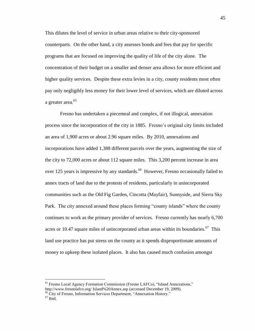
Fresno has undertaken a piecemeal and complex, if not illogical, annexation
process since the incorporation of the city in 1885. Fresno‘s original city limits included
an area of 1,900 acres or about 2.96 square miles. By 2010, annexations and
incorporations have added 1,388 different parcels over the years, augmenting the size of
the city to 72,000 acres or about 112 square miles. This 3,200 percent increase in area
over 125 years is impressive by any standards.66
However, Fresno occasionally failed to
annex tracts of land due to the protests of residents, particularly in unincorporated
communities such as the Old Fig Garden, Cincotta (Mayfair), Sunnyside, and Sierra Sky
Park. The city annexed around these places forming ―county islands‖ where the county
continues to work as the primary provider of services. Fresno currently has nearly 6,700
acres or 10.47 square miles of unincorporated urban areas within its boundaries.67
This
land use practice has put stress on the county as it spends disproportionate amounts of
money to upkeep these isolated places. It also has caused much confusion amongst
65
Fresno Local Agency Formation Commission (Fresno LAFCo), ―Island Annexations,‖
http://www.fresnolafco.org/ Island%20Annex.asp (accessed December 19, 2009). 66
City of Fresno, Information Services Department, ―Annexation History.‖ 67
Ibid.

46
residents and officials as to jurisdictional responsibilities to these pockets.68
Figure 31. Map of annexation history of Fresno displaying physical growth as the city expanded its borders.
These county islands are reminders of the past and are reference points that show
the relative growth of the city of Fresno on any local map. For example, when Pinedale,
which resides 6 miles north of downtown Fresno, received a post office in 1923, the city
limits of Fresno were 3 miles south of the community. By the mid-1970s, the city had
annexed all of the area surrounding it.69
Similarly, when Sunnyside, formerly known as
68
Fresno LAFCo, ―Island Annexations.‖ 69
City of Fresno, Information Services Department, ―Annexation History.‖

47
Maltermoro, received a post office in 1894, five years before the first annexation, the city
limits of Fresno were 3 miles west of the community. By the early-1980s, the city had
annexed all of the area surrounding it. These two examples show that growth was not
evenly distributed. To the southeast, south, southwest, and west of the city core, most
city growth still has not reached further than 2.5 miles, whereas to the east, most city
growth has extended just over 6 miles. However, Fresno has grown significantly more in
the northwest, north, and northeast with nearly all space up to the San Joaquin River
subdivided, populated, and annexed, this area covers ranges from 8 to 12 miles distance
from the city core. The growth northward is indicative of Fresno‘s land use policies as it
consistently made the regions south and west of the city less desirable places than those
regions north and east of the city.
South and West Fresno
The disincentives against the southern and western sections of the city developed
began from the outset of incorporation. In the 1880s, the west side consisted of a local
―Chinatown,‖ quartering off not only Asians, but also other immigrants and people of ill
repute. Authorities became negotiable there and corruption was rampant. It was the
city‘s foremost entertainment district, where lumberjacks, miners, and farm workers
could spend their paychecks.70
This made the west side an invaluable part of the early
Fresno economy, while it simultaneously marked the section with a lasting stigma.
In addition to the West Side developing a reputation as a center of vice, in 1891,
the City of Fresno constructed an outfall sewer to a 40-acre ‗sewer farm‘ about seven
70
Charles W. Clough et al., Fresno County in the 20th
Century: From 1900 to the 1980s, vol. 2 of An All
New History, ed. Bobbye Sisk Temple (Fresno, CA: Panorama West Books, 1986), 36.

48
miles west-southwest of town; the City soon increased this to 80 acres in order to
increase capacity. By 1909, the City further expanded the capacity of the farms to 892
acres. This place remains the site of the City‘s wastewater management. From 1933 to
1960, Fresno used sewage to irrigate nearby fields for cattle feed.71
It was not until 1947
that industrial sewage received primary treatment at a facility east-southeast of Fresno
prior to disposal.72
The result of this operation was an unhealthy and odious neighboring
environment effectively thwarting any growth near the farms.
Moreover, in 1937, the City purchased 20 acres for the nation‘s first modern
sanitary landfill just 3 miles southwest of downtown and about 1.5 miles from the extent
of existing city development. Although this site was much more than a dump, which
ordinarily produces rodent and debris problems, it still was the place where the City took
its refuse, emanating its own pungent scent. The Fresno Sanitary Landfill remained in
operation until 1987 making it also the nation‘s oldest landfill operation.73
Like the
sewer farms to the west, it deterred city development in its direction.
Lastly, mid-twentieth century zoning measures created an industrial corridor
along US Route 99 as well as an industrial block around then Hammer Field.74
Industrial
parks have worked as barriers in Fresno. When they arise, development on their backside
falters. The section south of the city core consists of the heavy industry, which blocked
off the remaining alternatives for city growth in that direction with non-industrial land
71
City of Fresno, Department of Public Utilities, ―Wastewater Plant History,‖ City of Fresno,
http://www.fresno.gov/
Government/DepartmentDirectory/PublicUtilities/Wastewater/AboutWastewater/WastewaterPlantHistory.h
tm (accessed December 20, 2009). 72
Clough, 62. 73
Martin V. Melosi, ―Fresno Sanitary Landfill,‖ National Historic Landmark Nomination (NPS Form 10-
900), US Department of Interior, National Parks Service (2000), http://historicfresno.org/nrhp/landfill.htm
(accessed December 20, 2009). 74
Daniel P. Faigin, ―State Route 99,‖ California Highways, http://www.cahighways.org/097-104.html#099
(accessed December 20, 2009).

49
uses. Along the highway corridor, at the now incorporated communities of Highway
City and Biola Junction seven miles northwest of downtown Fresno and going as far
northwest as the incorporated community of Herndon nearly ten miles from downtown
Fresno, a stretch of light industry lines SR 99 and the parallel UP tracks. Another
corridor exists along east-west UP tracks that merge with the main north-south line in
downtown Fresno. This industrial park is within two miles of the city core; it has formed
a barrier dividing the open space land use to the south and the mostly residential zones to
Figure 32. Existing land use map of Fresno.
Note: see key for legend in the appendix.

50
the north. Light industry also surrounds Fresno Air Terminal. Although city growth has
brought residences up to the northwestern corner of the airport, little exists to the east of
it.75
These borders have reduced the desirability of their respective areas, creating
vacuums that attract ever less traffic and decrease land values.
Figure 33. Map of relative wealth in Fresno by 1999 median family income.
75
City of Fresno, Information Services Department, ―Existing Land Use,‖ Zipped ESRI Shapefile,
http://www.fresno.gov/Government/DepartmentDirectory/InformationServices/GIS/Layers.htm (accessed
September 21, 2009).

51
North and East Fresno
The scene contrasts sharply to the north and east of downtown Fresno. Rural
sprawl had taken hold as the city struggled to keep pace with development through
annexations. On May 27, 1945, an article in the Fresno Bee reported that ―Fresno was
surrounded by and carried the burden for numerous thickly settled suburbs that totaled at
least 35,000 people.‖76
North of the city core, the City zoned commercial belts on east-
west Belmont and Olive Avenues in the 1930s and 1940s.77
Developers catered this area
to both pedestrians and automobiles with a few parking lots, on-street parking, and
narrow roads. However, in the mid-1950s, the City gave license to build a new shopping
complex called Manchester Center about three miles north of the city core on the north-
south Blackstone Avenue. This place was the first direct competitor with Fresno‘s
central business district. Sears Roebuck and Company closed down its operations
downtown to move to Manchester Center, while other large stores opened outlets.78
It
was the first truly automobile-oriented shopping center in the city with massive parking
lots that greatly increased accessibility to people living further away from downtown,
particularly in the north. It also cemented the City‘s commitment to making Blackstone
Avenue a commercial thoroughfare.
As suburbanization and, consequently, annexations pushed further north, the city
established two more east-west commercial belts at Shaw and Herndon Avenues.
Fashion Fair, a regional shopping center that was developed in 1970, represented the
City‘s first serious break with its general plan and college community plan adopted in
1958 and 1961 respectively, and updated in 1964 and 1965. The controversial move
76
Clough, 61. 77
City of Fresno, Information Services Department, ―Existing Land Use.‖ 78
Clough, 66.

52
changed the character of Shaw Avenue from a residential district into another commercial
thoroughfare rivaling Blackstone Avenue. Although many of the affected citizens
disapproved of the project, Fashion Fair successfully became and presently remains the
dominant mall in Fresno.79
This set precedent for the development of Herndon Avenue
in the 1990s as the City zoned it into another commercial thoroughfare two miles north of
Shaw Avenue. All of these shopping districts increased the desirability of land to the
north of the city. They also helped to send downtown Fresno and its shopping center, the
large-scale pedestrian-oriented Fulton Mall, which the City had completed in 1964, into
decay. Rather than creating barriers to development as the industrial parks had done, the
commercial strips created seams that promoted more growth beyond them. However,
northward city growth all but ceased as it reached the banks of the San Joaquin River; in
order to satiate demand, development has gone to the northeast into and beyond the city
of Clovis, turning it into essentially a suburb of Fresno.
79
Ibid., 72.

53
Figure 34. Land use map of Sierra Sky Park, Van Ness Extension, San Joaquin River Bluffs, and northern
extents of the West Side with barriers and seams overlaid.
Note: see p. 47 for legend on land use overlay and the appendix for its key.
To the east, much city growth took place initially during the 1920s through the
1940s, when developers constructed homes on the routes to the communities of
Sunnyside and Goldleaf. The Fresno fairgrounds split these two routes of development.
Two streetcar routes by way of the Sunnyside and Recreation Lines had serviced the area,
going between downtown Fresno, the fairgrounds, and the outside community. By 1960,

54
development had reached these two communities, extending Fresno‘s city limits along
with it. However, the subdivisions on the east side of the fairgrounds remained a part of
the county while the subdivisions to the north and to the south incorporated themselves
into Fresno.80
Situations such as this led to a city-wide campaign under Fresno Mayor
Ted Wills to extend city boundaries to the ―1975 Urban Unification line,‖ which the City
and County had collaborated on designating. This campaign continued under the
leadership of Joseph Levy, the president of Gottschalk‘s, a regional independent chain of
department stores. His theme was ―Square Off in ‘74; You Win When You‘re In,‖
implying lower taxes and more efficient government and services.81
In the end, much of
these county islands were annexed during this period, including those subdivisions next
to the fairgrounds. Despite the city‘s efforts, it was unable to annex either of the two still
unincorporated communities of Sunnyside and Goldleaf, which consequently became
county islands by the mid-1980s when city development had surpassed them.
Nonetheless, the city is making a concentrated effort to develop the section creating a
special planning district called the Southeast Growth Area. This district ―covers over 14
square miles and will eventually house 55,000 residents. This area was designated as the
City‘s major new growth community in the 2025 Fresno General Plan, acknowledged by
the County of Fresno in November 2002, and added to the City‘s Sphere of Influence in
May 2006.‖82
Land use plans heavily favored the expansion of the city northwards until
geographic and political obstacles became great enough to halt it at the San Joaquin
80
City of Fresno, Information Services Department, ―Annexation History.‖ 81
Clough, 79. 82
City of Fresno, Planning Department, ―Southeast Growth Area,‖
http://www.fresno.gov/Government/DepartmentDirectory/PlanningandDevelopment/Planning/SEGA/defau
lt.htm (accessed April 4, 2010).

55
River. As the northern extents have mostly thrived as a result of this course, the southern
extents have similarly wilted. Fresno has continually tried to keep up with development
through the annexation process, which has resulted in a fragmented city with many
county islands. Meanwhile, the implementation of general plans and the subsequent
zonings have created and reinforced a single land use structure with commercial districts
concentrated heavily around several thoroughfares, industrial parks built in close
proximity to each other, and government buildings throughout downtown, while
residential subdivisions fill the large void spaces between these zones. The result is an
expansive city with little land use diversity.
Conclusion
Fresno began as a Southern Pacific Railroad station in the dry and sparsely
populated San Joaquin Valley. It quickly became the principal city in the region
outpacing the growth of many other communities, eventually reaching its current
population 125 years later with nearly 500,000 residents. In this process, like any other
city, it went through periods of growth, decline, and stagnation. Nevertheless, Fresno
separated itself from other cities in the region with its location at the heart of the Valley
and its infrastructure that utilized this beneficial location. From horse-cars to streetcars to
buses to automobiles, the city developed proportionally to the limits of concurrent
mobility. When the city was still young, citizens settled in areas most convenient for
access to services, just as people do today. The result was a relatively dense initial urban
growth. This area transformed into a downtown as people settled further and further
away from the city center, finding lots near the various horse-car and, later, streetcar

56
lines. The advent of the automobile era came to Fresno sowed the first seeds of sprawl as
people began to move further away. Finally, at the end of World War II, the GI Bill
allowed returning veterans to apply for low interest home loans that made it possible for
millions of families to move into new suburban homes. This changed the housing
climate in America and still sixty years later, the ‗American Dream‘ culminates in the
purchase of a home. The impact of this trend on Fresno has been profound as the city
developed northward with tract homes and subdivisions until it reached the San Joaquin
River, approximately eight miles from the central business district. Freeway systems
built into the city further enabled this march northward. And now, the city with its bands
of commercial corridors amidst the sea of houses is facing a new trend that refocuses
development on the interior rather than on open space with its goal of becoming a more
livable community—one where a person can enjoy living, whether by driving, walking,
riding, or even flying. Fresno is a product of its past and, as such, must look back on it as
a reference for looking into future.

57
Appendix Table 2. Key for existing land use map legend (see pp. 47 and 51), Source: City of Fresno, Planning Department.
cc community commercial pcce convention center
ccr commercial-recreational pcsu California state university
ccv community commercial/part vacant pf public facility
cgh general heavy commercial pfg fairgrounds
cghv commercial general heavy/ part vacant pfs fire station
cn neighborhood commercial pgo government offices
cnl neighborhood commercial-limited phce county courthouse
cnv neighborhood commercial/ part vacant pm military
co office commercial pmoe municipal service center
cop professional services office commercial pnc neighborhood center
cov office commercial/ part vacant ppo post office
cp parking pps pump station
cpv parking-vacant pqch church
cr regional commercial pqchv church/ part vacant
csl storage limited commercial pqcm cemetery
f168 freeway 168 pqge PG&E substation
f180 freeway 180 pqhc convalescent hospital
f99 freeway 99 pqchv convalescent hospital/ part vacant
fwy freeway pqmc medical center
ih heavy industrial pqmh hospital
ihv heavy industrial/ part vacant pqmhv hospital/ part vacant
il light industrial pqp public/ quasi-public facility
ilv light industrial/ part vacant pqpv public/ quasi-public facility/ part vacant
oa open space/ agriculture pse elementary school
obp ponding basin pseh elementary and high school
obpv ponding basin/ part vacant psem elementary and middle school
om open space/ multi-use psh high school
or open space/ recreational use pshv high school-vacant
orbp ponding basin/ park psm middle school
orcz open space recreational use/ clear zone pss special school
orea open space/ environmental educational area pwrb water recharge basin
orgc open space/ golf course rh high density residential
orp open space/ recreational park rl low density residential
orpc open space/ community park rlv low density residential/ part vacant
orpn open space/ neighborhood park rm medium density residential
orpr open space/ regional park rmh medium high density residential
os open space rmht mobile home park
osc open space/ canal rmhv medium high density residential/ part
vacant
osg open space/ gravel mining rml medium low density residential
osw open space/ lake or pond rmlv medium low density residential/ part
vacant
out outside of sphere or in right of way rmv medium density residential/ part vacant
pa airport rr rural density residential
pacc community activity center rrv rural density residential/ part vacant
pc college v vacant parcel

58
Bibliography
Alex Harrell Designs. ―Historic Huntington Boulevard.‖
http://historichuntingtonblvd.com/About_Huntington_Blvd.html (accessed April
3, 2010).
Amalgamated Transit Union. ―History of ATU Local 1027.‖
http://atu1027.org/localatu.htm (accessed January 30, 2010).
Bureau of the Census, Population Division. ―Population Finder- 2008 Population
Estimates, Census 2000, 1990 Census.‖
http://factfinder.census.gov/servlet/SAFFPopulation?_submenuId=population_0&
_sse=on (accessed on April 4, 2010).
–——. Annual Estimates of the Population of Metropolitan and Micropolitan Statistical
Areas: April 1, 2000 to July 1, 2009.
http://www.census.gov/popest/metro/tables/2009/CBSA-EST2009-01.xls
(accessed December 20, 2009).
Bureau of the Census. ―2006-2008 American Community Survey.‖
http://factfinder.census.gov/servlet/DatasetMainPageServlet?_program=ACS&_s
ubmenuId=&_lang=en&_ts= (accessed March 28, 2010).
California Department of Transportation (Caltrans). Structure Maintenance and
Investigations. California Log of Bridges on State Highways, District 6 (October
2009). http://www.dot.ca.gov/hq/structur/strmaint/brlog2.htm (accessed January
4, 2010).
California High-Speed Rail Authority. ―Fact Sheet: December 2009 Business Plan Report
to the Legislature.‖
http://www.cahighspeedrail.ca.gov/images/chsr/20091214131634_FactSheetBusi
nessPlan.pdf (accessed January 30, 2010).
–——. ―Fact Sheet: December 2009 Business Plan Report to the Legislature.‖
http://www.cahighspeedrail.ca.gov/images/chsr/20091214131634_FactSheetBusi
nessPlan.pdf (accessed January 30, 2010).
City of Fresno, Department of Public Utilities. ―Wastewater Plant History.‖ City of
Fresno. http://www.fresno.gov/
Government/DepartmentDirectory/PublicUtilities/Wastewater/AboutWastewater/
WastewaterPlantHistory.htm (accessed December 20, 2009).
City of Fresno, Information Services Department. ―Annexation History.‖ Zipped ESRI
Shapefile.
http://www.fresno.gov/Government/DepartmentDirectory/InformationServices/GI
S/Layers.htm (accessed September 21, 2009).
–——. ―Existing Land Use.‖ Zipped ESRI Shapefile.
http://www.fresno.gov/Government/DepartmentDirectory/InformationServices/GI
S/Layers.htm (accessed September 21, 2009).
City of Fresno, Planning Department. ―Southeast Growth Area.‖
http://www.fresno.gov/Government/DepartmentDirectory/PlanningandDevelopm
ent/Planning/SEGA/default.htm (accessed April 4, 2010).
City of Houston Planning and Development Department. ―The Houston Setting.‖
Houston Land Use and Demographic Profile.

59
http://www.houstontx.gov/planning/planning_studies/ludem/pdf/chap1_houston_s
etting.pdf (accessed March 28, 2010).
Clough, Charles W. et al., Fresno County in the 20th
Century: From 1900 to the 1980s,
vol. 2 of An All New History, Edited by Bobbye Sisk Temple. Fresno, CA:
Panorama West Books, 1986.
Faigin, Daniel P. ―Part V: Modern Growth (1963-1969).‖ Chronology of California
Highways. http://www.cahighways.org/chrphas5.html (accessed December 27,
2009).
–——. ―State Route 125.‖ California Highways. http://www.cahighways.org/121-
128.html#125 (accessed December 27, 2009).
–——. ―State Route 168.‖ California Highways. http://www.cahighways.org/161-
168.html#168 (accessed December 27, 2009).
–——. ―State Route 41.‖ California Highways. http://www.cahighways.org/041-
048.html#041 (accessed December 27, 2009).
–——. ―State Route 41.‖ California Highways. http://www.cahighways.org/041-048.html
(accessed December 27, 2009).
–——. ―State Route 76.‖ California Highways. http://www.cahighways.org/073-
080.html#LR076 (accessed December 27, 2009).
–——. ―State Route 99.‖ California Highways. http://www.cahighways.org/097-
104.html#099 (accessed December 20, 2009).
–——. ―State Route 99.‖ California Highways. http://www.cahighways.org/097-
104.html#099 (accessed December 27, 2009).
Field, Andy and Alex Nitzman. ―California 99.‖ AARoads.
http://www.aaroads.com/california/ca-099.html (accessed December 27, 2009).
Fig Garden Homeowners Association. ―Christmas Tree Lane.‖
http://www.oldfig.org/about/christmastreelane.html (accessed January 14, 2010).
–——. ―History of the FGHA.‖ http://www.oldfig.org/about/history.html (accessed
January 14, 2010).
Fresno City and County Historical Society. ―Huntington Boulevard Historic Home Tour.‖
http://www.valleyhistory.org/hometourbrochure09.pdf (accessed January 15,
2010).
Fresno City College. ―Facts and History.‖
http://fresnocitycollege.edu/index.aspx?page=230 (accessed April 4, 2010).
Fresno Local Agency Formation Commission (Fresno LAFCo). ―Island Annexations.‖
http://www.fresnolafco.org/ Island%20Annex.asp (accessed December 19, 2009).
Habitat for Humanity Fresno County. ―A Neighborhood Revitalizes.‖
http://www.habitatfresno.org. (accessed April 3, 2010).
Hamm, Jr., Edward. When Fresno Rode the Rails. New York: Interurbans Publications,
1979.
Jacobs, Jane. The Death and Life of Great American Cities. 1961. Reprint, New York:
Random House, 1993.
Karana Hattersley-Drayton. ―Chandler Field/Fresno Municipal Airport Historic District.‖
Historic Fresno. http://historicfresno.org/district/chandler/intro.htm (accessed
January 3, 2010).
Kimley-Horn and Associates, Inc. ―Bus Rapid Transit Master Plan.‖ Plan. Council of
Fresno County Governments. Fresno, CA. June 17, 2008.

60
Marshall, Stephen. Streets & Patterns. New York: Spon Press, 2005.
Martin V. Melosi. ―Fresno Sanitary Landfill.‖ National Historic Landmark Nomination
(NPS Form 10-900). US Department of Interior, National Parks Service (2000).
http://historicfresno.org/nrhp/landfill.htm (accessed December 20, 2009).
Monson, William. ―Legends and Other Tales.‖
Powell, John Edward. A Preliminary Architectural Survey of Kerckhoff Avenue. Fresno,
CA: Fresno City College, 1991. http://historicfresno.org/district/hunting.htm
(accessed January 15, 2010).
Rehart, Catherine Morison. The Valley’s Legends & Legacies II. Clovis, CA: Quill Driver
Books/Word Dancer Press, Inc., 1997.
–——. The Valley’s Legends & Legacies. Clovis, CA: Quill Driver Books/Word Dancer
Press, Inc., 1996.
Schrank, David and Tim Lomax. ―The 2007 Urban Mobility Report.‖ Texas
Transportation Institute, The Texas A&M University System (September 2009).
http://tti.tamu.edu/documents/ums/mobility_report_2007_wappx.pdf (accessed
December 29, 2009).
Seeger, Dianne E.. ―Santa Fe Railroad Depot (1899).‖ National Record of Historic Places
Nomination. US Department of Interior, National Parks Service (1976).
http://historicfresno.org/nrhp/sfrr.htm (accessed January 2, 2010).
―Southern Pacific Passenger Depot (1889).‖ National Record of Historic Places
Nomination. US Department of Interior, National Parks Service (1978).
http://historicfresno.org/nrhp/sprr.htm (accessed January 2, 2010).
State of California, Department of Finance. E-1 population Estimates for Cities, Counties
and the State with Annual Percent Change — January 1, 2008 and 2009.
Sacramento, California, May 2009.
http://www.dof.ca.gov/research/demographic/reports/estimates/e-1/2008-
09/documents/E-1%202009%20Internet%20Version.xls (accessed December 20,
2009).
SustainableCircles Corporation. ―2008 US City Rankings.‖
http://www.sustainlane.com/us-city-rankings/cities/fresno (accessed December
29, 2009).
US Department of Agriculture, Report of a Study of the California Highway System by
the United States Bureau of Public Roads to the California Highway Commission
and Highway Engineer, US Bureau of Public Roads (Washington, DC:
Government Printing Office, 1922), 11, http://www.archive.org/details/
reportofstudyofc00unitrich (accessed December 28, 2009).
Western Regional Climate Center. ―Fresno WSO AP, California.‖ March 15, 2010.
http://www.wrcc.dri.edu/cgi-bin/cliMONtpre.pl?ca3257 (accessed March 28,
2010).
Wilbur Smith Associates, ―City of Fresno: Downtown Transportation & Infrastructure
Study‖ (study, City of Fresno, Fresno, CA, October 2007).
Zack, Dan, Tower District Specific Plan Implementation Committee, and Wilma Quan,
Tower District Design Review Committee. ―Tower District Specific Plan Design
Guidelines.‖ City of Fresno (Fall 2004).