Urban morphology and urban fragmentation in Macau, China ...
14
Island Studies Journal, 12(2), 2017, pp. 199-212 Urban morphology and urban fragmentation in Macau, China: island city development in the Pearl River Delta megacity region Ni Sheng School of Business, Macau University of Science and Technology, Macau, China [email protected] U Wa Tang Macao Institute of Urban Development and Environmental Management, Macau, China [email protected] and Adam Grydehøj Island Dynamics, Denmark Institute of Island Studies, University of Prince Edward Island, Canada [email protected] ABSTRACT: The island city of Macau, part of China’s Pearl River Delta megacity region, has undergone urban fragmentation, occasioning transport problems and environmental inequalities as well as conditioning future urban development. Land scarcity associated with island spatiality encourages dense and incremental urban expansion, facilitated by coastal land reclamation, causing spatiotemporal urban fragmentation. The Macau Peninsula, formerly a hilly island, has expanded and become increasingly connected to the mainland over the centuries. Macau faces critical challenges regarding traffic congestion, environmental pollution, and lack of space for housing and other urban functions. As Macau becomes increasingly integrated into the Pearl River Delta megacity region, particularly through the construction of the Hong Kong-Zhuhai-Macau Bridge, the island city’s urban planning strategy uses land reclamation to create new urban zones. This may produce new urban space for social and economic development yet risks further urban fragmentation. We argue that spatially and historically sensitive geographical understandings of island city development and urban morphology are necessary for understanding Chinese urbanisation and coastal cities. Keywords: China, island cities, Macau, Pearl River Delta megacity region, urban fragmentation, urban morphology https://doi.org/10.24043/isj.25 © 2017 – Institute of Island Studies, University of Prince Edward Island, Canada. Introduction In recent decades, urban studies has become increasingly concerned with urban fragmentation, referring to the morphological differentiation of pieces of urban land and their dispersal within urban space (Carsjens & van Lier, 2002; Wei & Zhang, 2012). Graham and Marvin (2001) warn of the dangers of ‘splintering urbanism’, and Bremner (2017) shows how archipelago spatiality can encourage social, economic, and legal fragmentation. Harvey (2001, p. 350) has highlighted the paradox of urban fragmentation in the age of mobility:
Transcript of Urban morphology and urban fragmentation in Macau, China ...

Island Studies Journal, 12(2), 2017, pp. 199-212
Urban morphology and urban fragmentation in Macau,China: island city development in the Pearl River Deltamegacity region
Ni ShengSchool of Business, Macau University of Science and Technology, Macau, [email protected]
U Wa TangMacao Institute of Urban Development and Environmental Management, Macau, [email protected]
and
Adam GrydehøjIsland Dynamics, DenmarkInstitute of Island Studies, University of Prince Edward Island, [email protected]
ABSTRACT: The island city of Macau, part of China’s Pearl River Delta megacity region, hasundergone urban fragmentation, occasioning transport problems and environmental inequalities as wellas conditioning future urban development. Land scarcity associated with island spatiality encouragesdense and incremental urban expansion, facilitated by coastal land reclamation, causing spatiotemporalurban fragmentation. The Macau Peninsula, formerly a hilly island, has expanded and becomeincreasingly connected to the mainland over the centuries. Macau faces critical challengesregarding traffic congestion, environmental pollution, and lack of space for housing and otherurban functions. As Macau becomes increasingly integrated into the Pearl River Delta megacityregion, particularly through the construction of the Hong Kong-Zhuhai-Macau Bridge, the islandcity’s urban planning strategy uses land reclamation to create new urban zones. This may producenew urban space for social and economic development yet risks further urban fragmentation. Weargue that spatially and historically sensitive geographical understandings of island city developmentand urban morphology are necessary for understanding Chinese urbanisation and coastal cities.
Keywords: China, island cities, Macau, Pearl River Delta megacity region, urban fragmentation,urban morphology
https://doi.org/10.24043/isj.25
© 2017 – Institute of Island Studies, University of Prince Edward Island, Canada.
Introduction
In recent decades, urban studies has become increasingly concerned with urban fragmentation,referring to the morphological differentiation of pieces of urban land and their dispersal withinurban space (Carsjens & van Lier, 2002; Wei & Zhang, 2012). Graham and Marvin (2001) warnof the dangers of ‘splintering urbanism’, and Bremner (2017) shows how archipelago spatialitycan encourage social, economic, and legal fragmentation. Harvey (2001, p. 350) has highlightedthe paradox of urban fragmentation in the age of mobility:

Ni Sheng, U Wa Tang, & Adam Grydehøj
200
On the one hand we witness the greater fragmentation of the urban social space intoneighbourhoods, communities, and a multitude of street corner societies, while on theother telecommuting and rapid transport make nonsense of some concept of the city asa tightly-walled physical unit or even a coherently organized administrative domain.
Harvey (2001) emphasises American cities’ simultaneous expansion and deconcentration, yet thecombination of enhanced fragmentation and enhanced mobility also occurs within dense cities andnetworks of cities. The current paper explores geographical causes and environmental effects of urbanfragmentation within the small and densely populated city of Macau. Macau itself is integratinginto China’s emerging Pearl River Delta megacity region, perhaps the pinnacle of today’s movetoward large-scale, polycentric, designed urban systems of connected fragmentation (Bie et al., 2015).
As China continues undergoing explosive urbanisation, research into the fragmentation ofChinese cities has been gathering pace. In the context of rapidly expanding cities that attractmigrants and swallow up rural villages and industrial units, He and Qian (2016, p. 10) warn that:
The emergence of enclave spaces, increasing residential mobility, and socio-economicinequality, coupled with the increasing commodification of urban space, has resulted invisible socio-spatial segregation, fragmentation and division. […] Featuring a high degreeof heterogeneity within and between different types of neighbourhoods, enclave urbanismin China entails a complex relationship between urban form and social fabric.
Most research into urban fragmentation in China has focused on megacities such as Beijing,Shanghai, and Guangzhou (Chen et al., 2014; Gao et al., 2014; Kuang et al., 2014; Li et al., 2013;Schneider et al., 2005; You, 2016a, 2016b; Yu & Ng, 2007; Yue et al., 2013) and key regionssuch as the Beijing-Tianjin-Hebei region and the Pearl River Delta as a whole (Lin, 2001; Tanet al., 2005; Yao & Liu, 1995). Urban fragmentation in China’s island cities per se has not beena focus of study, with just a few exceptions (e.g., Su, 2017; Hong, 2017). Such research is crucial,however, not just because the spatial characteristics of island cities are associated with a couplingof high urban density and slow spatial expansion (Grydehøj, 2015a)—which renders impossiblemany expansion-oriented urban solutions—but also because of under-recognition of the rolesuch island cities play in wider networks of coastal cities in China and elsewhere in Asia. That is,the American and European foundations of much research into urban fragmentation may be onlyproblematically applicable to Chinese island cities and the networks of which they form a part.We argue that spatially and historically sensitive geographical understandings of island citydevelopment are necessary if we are to understand Chinese urbanisation more broadly.
Grydehøj (2015a) posits that the benefits to island spatiality encourage dense urbanisationbut also encourage land reclamation, which can cause island and mainland to merge, rendering theislandness of island cities invisible. It is thus that the island origins of many urban centres in the regionare no longer evident. Yet cities in general, and perhaps island cities in particular, are characterisedby “a confluence of spatiotemporal factors (whether human or machine) that abidingly guidedevelopment in interplay with further external inputs” (Grydehøj, 2014a, p. 207). A city’s islandspatiality conditions certain developmental choices, which in turn condition future choices, evenafter the city has merged with the mainland and ceased to be self-evidently an island.
The island city of Macau is a prime example of this process. Like many cities, Macau facescritical challenges as a result of traffic congestion and problematic urban renewal, which in turnhinder social, economic, and environmental development. Macua’s archipelagic status influencesdevelopment in ways that have been poorly understood by administrators and scholars: incrementalland reclamation has led to spatiotemporal urban fragmentation. This paper elaborates uponMacau’s historical development and analyses its urban fragmentation and the impacts this has hadon transport and the urban environment over time, drawing upon data presented in previousstudies (Sheng & Tang, 2011; Sheng & Tang 2013; Tang & Wang, 2007).
Island Studies Journal, 12(2), 2017, pp. 199-212
201
Macau and the Pearl River Delta megacity region
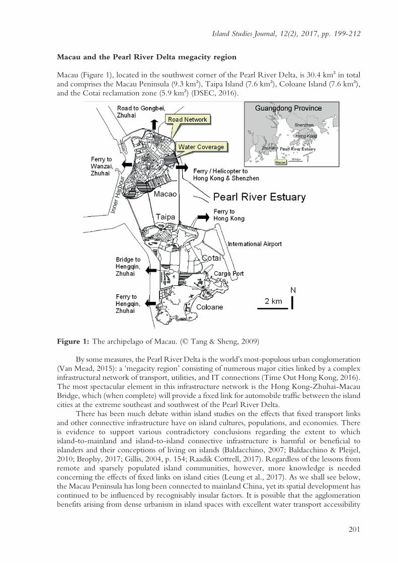
Macau (Figure 1), located in the southwest corner of the Pearl River Delta, is 30.4 km2 in totaland comprises the Macau Peninsula (9.3 km2), Taipa Island (7.6 km2), Coloane Island (7.6 km2),and the Cotai reclamation zone (5.9 km2) (DSEC, 2016).
Figure 1: The archipelago of Macau. (© Tang & Sheng, 2009)
By some measures, the Pearl River Delta is the world’s most-populous urban conglomeration(Van Mead, 2015): a ‘megacity region’ consisting of numerous major cities linked by a complexinfrastructural network of transport, utilities, and IT connections (Time Out Hong Kong, 2016).The most spectacular element in this infrastructure network is the Hong Kong-Zhuhai-MacauBridge, which (when complete) will provide a fixed link for automobile traffic between the islandcities at the extreme southeast and southwest of the Pearl River Delta.
There has been much debate within island studies on the effects that fixed transport linksand other connective infrastructure have on island cultures, populations, and economies. Thereis evidence to support various contradictory conclusions regarding the extent to whichisland-to-mainland and island-to-island connective infrastructure is harmful or beneficial toislanders and their conceptions of living on islands (Baldacchino, 2007; Baldacchino & Pleijel,2010; Brophy, 2017; Gillis, 2004, p. 154; Raadik Cottrell, 2017). Regardless of the lessons fromremote and sparsely populated island communities, however, more knowledge is neededconcerning the effects of fixed links on island cities (Leung et al., 2017). As we shall see below,the Macau Peninsula has long been connected to mainland China, yet its spatial development hascontinued to be influenced by recognisably insular factors. It is possible that the agglomerationbenefits arising from dense urbanism in island spaces with excellent water transport accessibility

Ni Sheng, U Wa Tang, & Adam Grydehøj
202
(Grydehøj, 2015a), which historically nurtured island cities early in their development, may befurther strengthened down the line by fixed transport links for trains and automobiles.
As Simpson (2014, p. 830) notes, the Pearl River Delta megacity region is “a discontinuousurban form comprised of a number of enclave zones, each with a particular function.” Thisproliferation of enclaves and functional distinctions is linked to the region’s river delta geography,with island and archipelago spatialities encouraging the development of important trading postsin Guangzhou (capital of Guangdong Province), Hong Kong (a former British colony), and Macau(a former Portuguese colony), which in turn encouraged the urbanisation of nearby islands and coastalzones such as Shenzhen and Zhuhai (Special Economic Zones adjacent to Hong Kong and Macaurespectively) as well as Dongguan, Zhongshan, and Jiangmen. Island cities of this sort are networkedby nature and design: remoteness, inaccessibility, and lack of connectivity would occasion thedemise of these places’ distinctive urban island lifestyles and practices, not accentuate their islandness.
Historical development of Macau: from tombolo to peninsula
Macau’s modern history can be divided into two periods, coinciding with the respective economicbooms of Portugal and China (Sheng & Tang, 2015). The first period began in 1557, when theChinese Emperor gave tacit approval for Portuguese occupation of a portion of what is today theMacau Peninsula. The Portuguese subsequently established a Western trade monopoly with China,and Macau soon became the major regional economic centre for Europeans trading with Asian states.The Portuguese gradually expanded their administration across the whole of the Macau Peninsulaand eventually occupied three additional adjacent islands, i.e., Taipa, Coloane, and Ilha Verde.
The second period began on 20 December 1999, when Macau ceased to be a Portuguesecolony and became a Special Administrative Region of China. Macau is now the only city inChina to permit gambling and, like Hong Kong across the Pearl River Delta, functions underthe ‘one country, two systems’ model of differential governance. Macau’s gambling revenues in2013 reached US$45 billion, seven times greater than those of Las Vegas (Riley, 2014). As far asculture is concerned, the Historic Center of Macao was awarded ‘World Cultural Heritage’ statusby the United Nations Educational, Scientific and Cultural Organization (UNESCO), whichcited the “dramatic mixing of eastern and western buildings in this jewel” (UNESCO, 2005).
In order to understand how Macau reached its present form and to identify the hiddenforces that island spatiality exerts on urban development, it is first necessary to study the historyof Macau’s landscape. With a few exceptions (e.g., Grydehøj, 2015b; Li, 2016; Zadori, 2016),Macau’s island or archipelago status has rarely been remarked upon, much less used as an analyticalperspective, in the literature. The Macau Peninsula was not always a peninsula but was once anisolated island, which only gradually became connected to mainland China as a tombolo orland-tied island (i.e., an island attached to the mainland by a narrow strip of land).
Figure 2: Tombolo formation and land reclamation in Macau. (Modified from © Vong, 2009).

Island Studies Journal, 12(2), 2017, pp. 199-212
203
As Miyahara et al. (2014) describe, a tombolo may form when waves sweep sediment alongboth coasts of a near-shore island, meeting at the back of the island and depositing material there.Two sand spits then gradually form on the opposite banks, and when these two spits meet andjoin, the isolated island becomes tied to the mainland (Figure 2). Numerous authors have notedthat presqu’iles (‘almost islands’) and peninsulas can have effects reminiscent of and be subject tosimilar processes as islands (Hayward, 2016; Hayward & Fleury, 2016; Johnson & Kuwahara,2016; Mendas, 2016).
When Portuguese colonialists settled in the south of Macau in 1557, the landscape was primarilyhilly. The Chinese village of Mongha had been established at the southern end of the tombolo (i.e.,the northern end of the then-island), where most of the flat and cultivated land was located. Thereafter,natural sedimentation and artificial land reclamation occurred successively on both sides of thetombolo and around the rest of the coast to support urban growth. The narrow tombolo disappeared,and the island of Macau became a peninsula. In 1561, the island of Macau had a population of just500. By March 2015, the mere 9.3 km2 of the Macau Peninsula held around 520,000 residents(DSEC, 2016). The Macau Peninsula’s population density of 55,900 inhabitants/km2 is nearly3.5 times that of Hong Kong Island. Most of the land area of the Macau Peninsula is composedof artificial ‘reclaimed’ land (Figure 3, bottom right).
Figure 3: Top: Macau as a tombolo in 1796 (© Câmara Municipal de Macau Provisória, 2001);Bottom left: Significant coastline change (© Tang & Sheng, 2009); Bottom right: Geologicalmap (© Macau Government).

Ni Sheng, U Wa Tang, & Adam Grydehøj
204
Urban fragmentation and environmental problems
Previously published data by the authors (Sheng & Tang, 2011; Sheng & Tang 2013; Tang &Wang, 2007) inform the following analyses of traffic, pollution levels, and road and building ratioswith regard to the Macau Peninsula’s spatial development.
Urban growth on the Macau Peninsula can be divided into four phases: 1557-1846, 1846-1912,1912-1957, and 1957-present. These phases of expansion resulted in distinct urban growth areas,here designated as Urban Fragments 1-4 (Figure 4). The Macau Peninsula’s urban fragments arevery small, each covering less than 3 km2. Although Macau’s economic and demographicdevelopment has been continual and often rapid since 1557, urban growth has been modest interms of land cover due to Macau’s special political and geographical conditions. Politically, thePortuguese acquired only a small piece of land (Urban Fragment 1) as a trading station in theearly stages of the colony. The remainder of the peninsula (Urban Fragment 2 and about half ofUrban Fragment 3) comprised Chinese farmland and villages but was gradually occupied by thePortuguese for urban development, becoming virtually absorbed into the Portuguese colony bythe 20th Century. Thereafter, land reclamation (the rest of Urban Fragment 3 and all of UrbanFragment 4) became the only means of providing for further growth. The rate of urban growththrough coastal land reclamation was nevertheless slow, for both economic and political reasons.Coastal land reclamation was politically sensitive since China never regarded Portugal’s rights inMacau as extending into the territory’s surrounding marine areas (Tang & Sheng, 2009). As aresult, the four centuries of Portuguese rule saw only relatively modest land reclamation projects.
Figure 4: Small urban fragments on the Macau Peninsula. (© Sheng & Tang, 2017)
As they did in other colonial trading stations (often islands) in Africa and India (e.g., Steyn,2015), the Portuguese in Macau began constructing defensive walls around the settlement at anearly stage, starting in 1569. This clashed with the policy of China’s Ming government, whichforbade the construction of city walls, and Macau’s walls were demolished on several occasionsas a result. With the emergence of Dutch maritime power in the region in 1612, Portugueserepresentatives from Macau travelled to Canton (today’s Guangzhou), the capital of GuangdongProvince, to argue that fortifications were required to defend Macau against Dutch incursion

Island Studies Journal, 12(2), 2017, pp. 199-212
205
(Garrett, 2010). Especially after the Portuguese soldiers and missionaries successfully repelled aDutch invasion in 1622, the Portuguese found an excuse to construct city walls and forts aroundtheir settlement, making Macau a tightly guarded place. The section of the old city walls thatremains today has been inscribed as part of the UNESCO Historic Center of Macao.
The city could only be entered through a small number of arched gateways in the citywalls. The Portuguese colonialists lived within this confined area for over 200 years (1557-1794).This is the only fragment in Macau today with squares, cobbled streets, and alleyways possessingan intimate, human and cosy scale, reflecting the urban landscape of late-Medieval Portugal(Guillén-Nuñez, 2001). Buildings cover 71% of this urban area, road space 8%, green space 2%,and water <1% (Sheng & Tang, 2011). Similar to the historic centre of Lisbon, Urban Fragment 1possesses a compact morphology, and the road network has a complex non-rectilinear pattern, whichwas originally designed for pedestrian and human-powered transport such as litters and sedan chairs.65.8% of the roads in this historic urban centre are less than 10 m wide (Sheng & Tang, 2011).
Figure 5: Historic centre of Macau. (© Sheng & Tang, 2017)
The complex curvature of the road network and the high percentage of narrow roads limittraffic speed, traffic capacity, and parking capacity in this urban fragment. Traffic volumes onmost roads in Urban Fragment 1 are very low (200-400 vehicles/hour) compared with those inother urban fragments (1500-3000 vehicles/hour during evening rush hour). The reason for thisis that drivers lack motivation to drive vehicles into the area and prefer to walk or use publictransport instead. As a result, about 65% of traffic noise levels along the major pedestrian sidewalksin this area meet the National Standard of 70 dB(A) (Sheng & Tang, 2011). However, the largestreet canyon effect in the historic urban fragment decreases dilution of air pollution fromground-based traffic emission sources. The old town’s canyon geometry can be defined by theratio H/W, where H is the height of the canyon walls (buildings) and W is the canyon width(road width). Urban Fragment 1 has been found to have the city’s highest H/W (1.9), i.e., onaverage, the building height is almost twice the width of the road. Thus, although traffic volumesare much lower than those in other urban fragments, concentrations of air pollutants are notsignificantly lower (Tang & Wang, 2007). Particularly during evening rush hour, with a northerlywind direction (sector 0-20º), two UNESCO world heritage monuments in Urban Fragment 1

Ni Sheng, U Wa Tang, & Adam Grydehøj
206
(the Leal Senado building and the Cathedral) have been measured as exposed to excessive nitrogendioxide concentrations of 135.9 and 121.1 lg/m3 respectively (Sheng & Tang, 2013).
In the next phase of Macau’s development (1846-1912), the city expanded and underwentmorphological change. This period coincided with wider European experiments with the associationbetween connective infrastructure, urban expansion, and social control. For example, Georges-Eugene Haussmann’s 1853 street plan for Paris involves twelve boulevards radiating out from theArc de Triomphe. This street plan represented an early attempt to modernise Paris’ historic centre,which was dominated by crowded, unhealthy, and dangerous Medieval neighborhoods. Someresearchers suggest that Haussmann’s boulevards were also designed to make it easier for themilitary to maneuver and suppress armed insurrection (e.g., Graham, 2011, p. XVII).
Macau adopted a similar urban plan, with the construction of squares with boulevardsradiating out in different directions across newly occupied areas, i.e., the rural areas, Chinesevillages, and farmlands of Urban Fragment 2. In 1846, four years after the Opium War(1839-1842) and at the nadir of the Chinese state’s power, the dynamic Portuguese military officerJoão Maria Ferreira do Amaral was appointed the 79th Governor of Macau. During his three-yeartenure as governor, he started implementing a series of policies to aggressively entrench Portugal’scolonial authority over the territory and made a plan to gradually occupy all seven of the Chinesevillages to the north of the Portuguese settlement on the Macau Peninsula as well as the threenearby islands of Taipa, Coloane, and Ilha Verde. The colonial occupation of the peninsula andislands was complete by the 1880s, when the two largest Chinese villages—Longtian andMongha—on the northern half of the Macau Peninsula were fully occupied and administered bythe Portuguese. The Portuguese adopted an urban plan that involved the construction of squaresalong the northern city wall, from which boulevards reached out toward the coasts. Bearing inmind that the military centre was located within the northern city wall, these boulevards assistedthe Portuguese military in accessing the entirety of the peninsula.
Urban Fragment 2’s radiating road network leads to higher traffic accessibility than UrbanFragment 1’s curved road network. The proportion of 10-20 m wide roads in Urban Fragment 2(40.6%) is double that in Urban Fragment 1, allowing for higher traffic capacity, accessibility, andvolumes. Over 50% of Urban Fragment 2’s roads have traffic volumes above 1500 vehicles/hourin evening rush hour. Only about 50% of traffic noise levels along the major pedestrian sidewalksmeet the National Standard of 70 dB(A) (Sheng & Tang, 2011). Similar to Urban Fragment 1,concentrations of air pollutants are high due to the high H/W of 1.6 (Tang & Wang, 2007).
Urban Fragment 3 has been developed since 1912 and reflects modern urban design,which reserves more land for social welfare, industrial, and transportation uses. Water coveragehas increased as a result of the construction of a reservoir for fresh water supply, an importantresource in an island enclave. The road network has a modern rectilinear grid pattern. Theproportion of roads less than 20 m wide decreases to 65.5%, while that of roads 20-30 m wideincreases to 23.2%. As a result of infill development of high-rise buildings, only 67.1% of thefragment’s buildings are lower than 30 m, whereas the proportion of those with a height of 40-80m has increased. With high traffic volumes on most roads, Urban Fragment 3 has the highestaverage traffic noise among the four urban fragments. Only about 19% of traffic noise levels alongthe major pedestrian sidewalks meet the National Standard of 70 dB(A) (Sheng & Tang, 2011).
A new wave of coastal land reclamation since 1957 has led to the development of UrbanFragment 4, reflecting the most recent trend of cluster development, which is less dense than theother urban forms and has the lowest building lot space and the highest road space, green space,water coverage, and land consumption per capita. The proportion of high-rise buildings 50-60m in height increases to 39.5% to maintain high gross densities. The proportion of roads 20-30m wide increases significantly to 67.7% to serve the increasing demands of vehicular transport.A large rectangular grid pattern has been adopted to allow for wider roads and larger buildingblocks. Traffic congestion has been reduced through the adoption of additional wide roads anda lower density of intersections in the road network design. As a result, the average traffic noise

Island Studies Journal, 12(2), 2017, pp. 199-212
207
is 69.3 dB(A), which is the lowest of the four urban fragments. The percentage of traffic noiselevels along the major pedestrian sidewalks meeting the National Standard of 70 dB(A) is about51% (Sheng & Tang, 2011). The average H/W in Urban Fragments 3 and 4 are around 1.0-1.2.This lower H/W leads to increased dilution of air pollutants from ground-based traffic emissionsources (Tang & Wang, 2007).
Since land is among the most precious resources for island cities, urban growth in islandcities is frequently accompanied by massive land reclamation along the coasts—sometimesoccasioning social problems and inequalities (Grydehøj, 2015b). Macau’s urban and economicgrowth have come at the cost of the peninsula’s former bays, which have been filled in to createnew land while two large artificial lakes have since been created in the southwest coastal reclamationprojects. These estuarine lakes aim to retain, if not quite fully preserve, the historic coastallandscape of the old Praia Grande bay, which provides a view of Penha Church, the oldest westernchurch in Asia and part of Macau’s world heritage, atop Penha Hill (Tang & Sheng, 2009).
Macau’s historically contingent growth has led to the development of highly distinct urbanfragments, which has occasioned spatial inequalities in environmental health. Macau’s island statusnot only drove its selection as the site for a Portuguese trading port but has since significantlyinfluenced the manner in which the city has undergone incremental expansion, with successivephases of land reclamation serving in particular to create spatial divisions among various urbanfunctions (Grydehøj, 2015b). For all its explosive population growth, Macau can escape neitherits history nor its islandness.
Future urban fragments
Over the next two decades, Macau will enter a new phase in its history with the implementationof an ambitious land reclamation program that will add more than 12% to the territory’s land areaand create five new districts: Urban Zones A, B, C, D, and E (Figure 6). Urban Zones A and Bare in the northeast and southeast of the Macau Peninsula respectively, while Urban Zones C,D, and E are on the north coast of Taipa.
Figure 6: Five new urban zones A, B, C, D and E in the future (© Macau Government, 2009,http://ibs.gcs.gov.mo/files/image_b/20091130/0730112009.jpg)
Ni Sheng, U Wa Tang, & Adam Grydehøj
208
According to the government’s master plan, Urban Zone A, the largest of the five, will beused for public housing, community recreation, and culture. It is expected to provide housingfor around 57,000 people in around 19,000 housing units. To the east of Urban Zone A will bean artificial island, built for the Hong Kong-Zhuhai-Macau Bridge, which is currently underconstruction. Urban Zone B will mainly be used for administrative offices, with priority givento judicial services and tourism. There will also be a promenade area with gardens by the sea,addressing the wider island city tendency for a lack of sea access (e.g., Swaminathan, 2014). Partof Urban Zone B will be reserved for housing and shopping. It will provide housing for around6,000 people in around 2,000 housing units. It has been suggested that Urban Zone B should“harmonise with Macao’s world heritage landscape and give continuity to the city centre function”(Macauhub, 2015). Urban Zones C, D, and E are expected to house 67,000 people in around22,000 housing units. These three zones are designed as low-carbon pilot areas. The coast alongthe three zones “will be designated as a green corridor,” where citizens and tourists can be incontact with the water and enjoy leisure activities (Lages, 2015; Macauhub, 2015). Such urbandesign utilises the questionable benefits of island spatiality for showcasing urban sustainability(Grydehøj & Kelman, 2016).
This use of reclaimed land, particularly reclaimed islands, is part of a wider trend to useislands within cities as containers for functionally differentiated urban development (Grydehøj, 2014b,p. 187). Through the newly reclaimed urban zones, the government hopes to provide necessaryspace for Macau’s long-term transportation planning, beautify the coast, and expand the overallurban space. This urban planning strategy seeks to break through the constraints that limited landresources place on Macau’s social and economic development. The potential for even furtherurban expansion in the future has been facilitated through the Chinese state’s granting of 85 km2of marine territory to Macau in December 2015 (Macao Government Information Bureau, 2015).
Conclusion
Specific geographical, political, and socioeconomic contexts should be considered in investigationsof urban fragmentation. Macau’s island status has had a variety of important consequences for thecity’s urban fragmentation. This paper has provided an overview of Macau’s historicaldevelopment and analysed how the island spatiality-conditioned fragmentation of Macau’s urbanforms has influenced transport, the urban environment, and ultimately distribution of urbanqualities and functions.
Because Macau Peninsula was once a small, hilly island that gradually expanded andconnected to mainland China as a peninsula, the city’s growth occurred in distinct andgeographically contingent phases (i.e., 1557-1846, 1846-1912, 1912-1957, and 1957-present).This has resulted in the formation of four small urban fragments (<3 km2). Urban Fragment 1reflects the urban landscape of late-Medieval Portugal as the area was confined by historic citywalls against maritime incursion during 1557-1846. Urban Fragment 2 was formed when roadswere designed to radiate from the military centre out towards the coast during 1846-1912,reflecting mid-19th century European urban design. Urban Fragments 3-4 were formed by variousphases of coastal land reclamation, reflecting modern urban design since 1912. Macau’s historicallycontingent growth has led to the development of highly distinct urban fragments, which has inturn led to spatial inequalities in environmental health. Macau’s history of coastal land reclamationcannot be separated from its urban fragmentation. Island cities often densify and expand in fitsand starts through piecemeal land reclamation, resulting in spatiotemporal divisions within thecity, which abidingly condition future development.
The construction of five new urban fragments (increasing Macau’s land area by 12%) isdesigned to provide additional urban space to improve residents’ quality of life but it also representsa continuation of a centuries-long process of island city morphological transformation. This isespecially relevant in light of Macau’s increasing connectivity to the wider Pearl River Delta

Island Studies Journal, 12(2), 2017, pp. 199-212
209
megacity region, particularly in the form of the Hong Kong-Zhuhai-Macau Bridge. How willMacau’s new urban zones interact with existing and emerging urban space in and beyond the city?
More generally, this paper has illustrated the necessity of an urban island studies perspectiveon Chinese coastal cities, which may defy western understandings of urbanisation processesprecisely because of their island and archipelago geographies. Even the Pearl River Delta megacityregion, at the vanguard of today’s trend for explosive and connective urbanism, is being mouldedby types and scales of deep-rooted spatiotemporal factors that are foreign to North American andEuropean experience.
Acknowledgments
This study was supported by the Faculty Research Grant in Macau University of Science andTechnology (FRG-17-021-MSB).
References
Baldacchino, G. & Pleijel, C. (2010). European islands, development and the cohesion policy: acase study of Kökar, Åland Islands. Island Studies Journal, 5(1), 89-110.
Baldacchino, G. (2007). Fixed links and the engagement of islandness: reviewing the impact ofthe Confederation Bridge. Canadian Geographer, 51(3), 323-336.https://doi.org/10.1111/j.1541-0064.2007.00181.x
Bie, J., Jong, M.D., & Derudder, B. (2015). Greater Pearl River Delta: historical evolutiontowards a global city-region. Journal of Urban Technology, 22(2), 103-123.https://doi.org/10.1080/10630732.2014.971575
Bremner, L. (2017). Observations on the concept of the aquapelago occasioned by researchingthe Maldives. Shima, 11(1), 18-29. https://doi.org/10.21463/shima.11.1.05
Brophy, J.E. (2017). Reiterating the boundary: community discourse in light of proposedtechnological change on Vinalhaven Island, Maine, USA. Island Studies Journal, 12(1),187-206. https://doi.org/10.24043/isj.12
Carsjens, G.J., & van Lier, H.N. (2002). Fragmentation and land-use planning: an introduction.Landscape and Urban Planning, 58(2-4), 79-82. https://doi.org/10.1016/S0169-2046(01)00210-9
Chen, J., Chang, K.T., Karacsonyi, D., & Zhang, X. (2014). Comparing urban land expansionand its driving factors in Shenzhen and Dongguan, China. Habitat International, 43, 61-71.https://doi.org/10.1016/j.habitatint.2014.01.004
DSEC (2016). 2016 Macao in figures. Statistical Information System of Macao. Retrieved fromhttp://www.dsec.gov.mo/CMSPages/e_mn_indicator.aspx
Gao, J., Wei, Y.D., Chen, W., & Chen, J. (2014). Economic transition and urban land expansionin provincial China. Habitat International, 44, 461-473.https://doi.org/10.1016/j.habitatint.2014.09.002
Garrett, R.J. (2010). The defences of Macau: forts, ships and weapons over 450 years. Hong Kong:Hong Kong University Press. https://doi.org/10.5790/hongkong/9789622099937.001.0001
Gillis, J. (2004). Islands of the mind: how the human imagination created the Atlantic world. Houndmills:Palgrave Macmillan.
Graham, S. (2011). Cities under siege: the new military urbanism. London & New York: Verso.Graham, S. & Marvin, S. (2001). Splintering urbanism: networked infrastructures,technological mobilities
and the urban condition. London: Routledge. https://doi.org/10.4324/9780203452202Grydehøj, A. & Kelman, I. (2016). Island smart eco-cities: innovation, secessionary enclaves, and
the selling of sustainability. Urban Island Studies, 2, 1-24.https://doi.org/10.20958/uis.2016.1
Grydehøj, A. (2015a). Island city formation and urban island studies. Area, 47(4), 429-435.https://doi.org/10.1111/area.12207

Ni Sheng, U Wa Tang, & Adam Grydehøj
210
Grydehøj, A. (2015b). Making ground, losing space: land reclamation and urban public space inisland cities. Urban Island Studies, 1, 96-117. https://doi.org/10.20958/uis.2015.6
Grydehøj, A. (2014a). Constructing a centre on the periphery: urbanization and urban design inthe island city of Nuuk, Greenland. Island Studies Journal, 9(2), 205-222.
Grydehøj, A. (2014b). Understanding island cities. Island Studies Journal, 9(2), 183-190.Guillén-Nuñez, C. (2001). Macau’s rich heritage and cultural diversity. Macau Focus, 1(3), 7-16.Harvey, D. (2001). Spaces of capital: towards a critical geography. New York: Routledge.Hayward, P. (2016). Towards an expanded concept of island studies. Shima, 10(1), 1-7.
https://doi.org/10.21463/shima.10.1.03Hayward, P., & Fleury, C. (2016). Absolute waterfrontage: road networked artificial islands and
finger island canal estates on Australia’s Gold Coast. Urban Island Studies, 2, 25-49.https://doi.org/10.20958/uis.2016.2
He, S., & Qian, J. (2016). From an emerging market to a multifaceted urban society: urban Chinastudies. Urban Studies, 54(4), 827-846. https://doi.org/10.1177/0042098016675826
Hong, G. (2017). Locating Zhuhai between land and sea: a relational production of Zhuhai,China, as an island city. Island Studies Journal, 12(2). https://doi.org/10.24043/isj.16
Johnson, H. & Kuwahara, S. (2016). Sakurajima: maintaining an island essence. Shima, 10(1),48-66. https://doi.org/10.21463/shima.10.1.07
Kuang, W., Chi, W., Lu, D., & Dou, Y. (2014). A comparative analysis of megacity expansionsin China and the U.S.: patterns, rates and driving forces. Landscape and Urban Planning, 132,121-135. https://doi.org/10.1016/j.landurbplan.2014.08.015
Lages, A. (2015). Macau land reclamation to be done in the next 5 years. Delta Bridge. Retrievedfrom http://deltabridges.com/macau/business/news/macau-land-reclamation-be-done-next-5-years
Leung, A., Tanko, M., Burke, M., & Shui, C.S. (2017). Bridges, tunnels, and ferries: connectivity,transport, and the future of Hong Kong’s outlying islands. Island Studies Journal, 12(2).https://doi.org/10.24043/isj.24
Li, S. (2016). The transformation of island city politics: the case of Macau. Island Studies Journal,11(2), 521-536.
Li, X., Zhou, W., & Ouyang, Z. (2013). Forty years of urban expansion in Beijing: what is therelative importance of physical, socioeconomic, and neighborhood factors? AppliedGeography, 38, 1-10. https://doi.org/10.1016/j.apgeog.2012.11.004
Lin, G.C.S. (2001). Metropolitan development in a transitional socialist economy: spatialrestructuring in the Pearl River Delta, China. Urban Studies, 38(3), 383-406.https://doi.org/10.1080/00420980120027429
Macao Government Information Bureau (2015). Macao to administrate 85 square kilometres of waters.Retrieved from http://www.gcs.gov.mo/showNews.php?PageLang=E&DataUcn=95418
Macauhub (2015). Macao builds a new frontier with ambitious reclamation. Retrieved fromhttp://www.macauhub.com.mo/en/2015/04/24/macao-builds-a-new-frontier-with-ambitious-reclamation/
Mendas, Z. (2016). Historico-economic traces in the former island cities of Zadar and Trogir.Shima, 10(1), 85-110. https://doi.org/10.21463/shima.10.1.09
Miyahara, S., Uda, T., & Serizawa, M. (2014). Prediction of formation of land-tied islands.Proceedings of 34th Conference on Coastal Engineering, Seoul, Korea, 34.https://doi.org/10.9753/icce.v34.sediment.7
Raadik Cottrell, J. (2017). Island community: identity formulation via acceptance through theenvironment in Saaremaa, Estonia. Island Studies Journal, 12(1), 169-186.https://doi.org/10.24043/isj.11
Riley, C. (2014). Macau’s gambling industry dwarfs Vegas. CNN Money. Retrieved fromhttp://money.cnn.com/2014/01/06/news/macau-casino-gambling/

Island Studies Journal, 12(2), 2017, pp. 199-212
211
Schneider, A., Seto, K.C., & Webster, D.R. (2005). Urban growth in Chengdu, Western China:application of remote sensing to assess planning and policy outcomes. Environment andPlanning B: Planning and Design, 32(3), 323-345. https://doi.org/10.1068/b31142
Sheng, N., & Tang, U.W. (2015). Spatial techniques to visualize acoustic comfort along culturaland heritage routes for a world heritage city. Sustainability, 7, 10264-10280.https://doi.org/10.3390/su70810264
Sheng, N., & Tang, U.W. (2013). Risk assessment of traffic-related air pollution in a worldheritage city. International Journal of Environmental Science and Technology, 10, 11-18.https://doi.org/10.1007/s13762-012-0030-1
Sheng, N., & Tang, U.W. (2011). Spatial analysis of urban form and pedestrian exposure to trafficnoise. International Journal of Environmental Research and Public Health, 8, 1977-1990.https://doi.org/10.3390/ijerph8061977
Simpson, T. (2014). Macau metropolis and mental life: interior urbanism and the Chineseimaginary. International Journal of Urban and Regional Research, 38(3), 823-842.https://doi.org/10.1111/1468-2427.12139
Steyn, G. (2015). The impacts of islandness on the urbanism and architecture of Mombasa. UrbanIsland Studies, 1, 55-80. https://doi.org/10.20958/uis.2015.4
Su, P. (2017). The floating community of Muslims in the island city of Guangzhou. Island StudiesJournal, 12(2). https://doi.org/10.24043/isj.18
Swaminathan, R. (2014). The epistemology of a sea view: mindscapes of space, power and valuein Mumbai. Island Studies Journal, 9(2), 277-292.
Tan, M., Li, X., Xie, E.H., & Lu, C. (2005). Urban land expansion and arable land loss in China:a case study of Beijing-Tianjin-Hebei region. Land Use Policy, 22(3), 187-196.https://doi.org/10.1016/j.landusepol.2004.03.003
Tang, U.W., & Sheng, N. (2009). Macao. Cities, 26(4), 220-231.https://doi.org/10.1016/j.cities.2009.02.005
Tang, U.W., & Wang, Z.S. (2007). Influences of urban forms on traffic-induced noise and airpollution: results from a modelling system. Environmental Modelling and Software, 22(12),1750-1764. https://doi.org/10.1016/j.envsoft.2007.02.003
Time Out Hong Kong (2016). The Pearl River Delta megacity. Time Out Hong Kong, 17 May.Retrieved from: https://www.timeout.com/hong-kong/en-hongkong/the-pearl-river-delta-megacity-051716
UNESCO (2005). World Heritage List: Historic Centre of Macao. Retrieved from:http://whc.unesco.org/en/list/1110
Van Mead, R. (2015). China’s Pearl River Delta overtakes Tokyo as world’s largest megacity.The Guardian, 28 January. Retrieved from:https://www.theguardian.com/cities/2015/jan/28/china-pearl-river-delta-overtake-tokyo-world-largest-megacity-urban-area
Vong, C.S. (2009). Geografia de Macau. Hong Kong: Joint Publishing.Wei, Y., & Zhang, Z. (2012). Assessing the fragmentation of construction land in urban areas:
an index method and case study in Shunde, China. Land Use Policy, 29(2), 417-428.https://doi.org/10.1016/j.landusepol.2011.08.006
Yao, S. & Liu, T. (1995). The evolution of urban spatial structure in the open area of southeasterncoastal China. Urban Geography, 16(7), 561-576. https://doi.org/10.2747/0272-3638.16.7.561
You, H. (2016a). Quantifying megacity growth in response to economic transition: a case ofShanghai, China. Habitat International, 53, 115-122.https://doi.org/10.1016/j.habitatint.2015.11.001
You, H. (2016b). Quantifying urban fragmentation under economic transition in Shanghai city,China. Sustainability, 8(1), 21. https://doi.org/10.3390/su8010021

Ni Sheng, U Wa Tang, & Adam Grydehøj
212
Yu, X.J., & Ng, C.N. (2007). Spatial and temporal dynamics of urban sprawl along twourban–rural transects: a case study of Guangzhou, China. Landscape and Urban Planning,79(1), 96-109. https://doi.org/10.1016/j.landurbplan.2006.03.008
Yue, W., Liu, Y., & Fan, P. (2013). Measuring urban sprawl and its drivers in large Chinesecities: the case of Hangzhou. Land Use Policy, 31, 358-370.https://doi.org/10.1016/j.landusepol.2012.07.018
Zadori, I. (2016). Cultural aspects of sustainability challenges of island-like territories: case studyof Macau, China. Ecocycles, 1(2), 35-45.