Geodiversity, karst and caves Karst Processes and Land forms.

A REPORT FOR THE DEPARTMENT OF PRIMARY INDUSTRIES,
PARKS, WATER AND ENVIRONMENT
AN OVERVIEW OF GEODIVERSITY SITES IN THE TASMANIAN
WILDERNESS WORLD HERITAGE AREA, WITH PARTICULAR
REFERENCE TO GEOLOGICAL SITES AND THE IDENTIFICATION OF
ANY GAPS IN THE LISTINGS
Keith D Corbett Consultant Geologist
June 2013
Nature Conservation Report Series 2013/05

Citation: Corbett, K. D. (2013). An overview of geodiversity sites in the Tasmanian Wilderness
World Heritage Area, with particular reference to geological sites and the identification of any gaps
in the listings – a report to the Department of Primary Industries Parks Water and Environment.
Resource Management and Conservation Division, Department of Primary Industries Parks Water
and Environment, Hobart, Nature Conservation Report Series 13/05.
This report was prepared under the direction of the Department of Primary Industries, Parks, Water and Environment
(World Heritage Area geodiversity program). Commonwealth Government funds were provided for this project
through the World Heritage Area program. The views and opinions expressed in this report are those of the author
and do not necessarily reflect those of the Department of Primary Industries, Parks, Water and Environment or those
of the Department of Sustainability Environment Water Population and Communities.
ISSN: 1441-0680 (book)
ISSN: 1838-7403 (web)
Copyright 2013 Crown in the right of State of Tasmania
Apart from fair dealing for the purposes of private study, research, criticism or review, as permitted under the Copyright Act, no
part may be reproduced by any means without permission from the Department of Primary Industries, Parks, Water and
Environment. Published by the Sustainable Landscapes Branch, Department of Primary Industries, Parks, Water and
Environment.
GPO Box 44 Hobart, 7001.
Cover photo: View over glacial lakes Malana and Wugata on the Denison Range, South-West
Tasmania, looking south along the Vale of Rasselas to Mt Wright and The Thumbs, with Mt Mueller
and Mt Anne on the horizon. Photo: Keith Corbett.

Overview of geodiversity sites TWWHA – geological sites – gaps in the listings 1
EXECUTIVE SUMMARY
1. This report is a summary and assessment of the geodiversity sites listed by the Natural
Values Atlas within the Tasmanian Wilderness World Heritage Area (TWWHA), compiled
as a consultancy contract for DPIPWE through the Geoconservation Section in the period
March – July 2013.
2. There are 291 geodiversity sites listed within the TWWHA. These have here been divided
according to geological age, with all of the landform sites (fluvial, glacial, karst, coastal, etc)
grouped as Quaternary/Recent.
3. There are 203 Quaternary/Recent sites (= 70%), of which the main groupings are glacial
regions, landforms and deposits (47), coastal features (45), karst regions, landforms and
deposits (22), fluvial landforms and deposits (19), and peat deposits and landforms (11), with
many minor categories (e.g. fossils, cliffs and escarpments, gorges, lakes, waterfalls, mass
movement features, etc).
4. There are seven Tertiary age sites (four structural features and three basalts); two
Cretaceous sites (one based on a poorly dated lamprophyre dyke, and the other being the
state-wide site for Cretaceous igneous rocks); seven Jurassic sites (five dolerite contacts,
one Jurassic basalt, and one for quartz crystal mineralisation); ten Permo-Triassic sites ( six
rock types or sequences, three unconformity surfaces, one for sedimentary structures); six
Devonian sites (five for mineralisation, one for a fold structure); two Siluro-Devonian sites
(one for fossils, one for a type section); eight Ordovician sites (seven rock units, one fossil
locality); 16 Cambrian sites (five rock units, four unconformities, four structures, three fossil
localities); and 31 Precambrian sites (26 for rock units, two for structures, two for regions,
one unconformity).
5. No glaring gaps have been identified in the listings.
6. Attention is drawn within the Quaternary/Recent sites of some apparent randomness in
selection of sites in some categories (e.g. River Gorges, Lakes, Cliffs and Escarpments). One
of the Regional Mountain Terrains sites is recommended for de-listing because of overlap
and lack of internal integrity, a new glacial site is recommended (Schnells Ridge), and the
possible inclusion of some lightning strike sites is suggested.
7. Inclusion of the undated lamprophyre of possible Cretaceous age seems unwarranted.

Overview of geodiversity sites TWWHA – geological sites – gaps in the listings 2
8. Some re-wording and redefinition of several of the Cambrian sites is recommended, to
include additional important features at the sites. Two more Cambrian fossil sites, both on
the South Coast, are recommended.
9. With respect to the Precambrian sites, several are recommended for re-definition, two are
considered as dubious, and one is recommended for de-listing (Jubilee Region) on the basis
of a lack of tectonic or palaeogeographic integrity.
10. Two general recommendations are made, one for careful overview of sites, in a ‘devil’s
advocate’ style, when they are being nominated, and another for consideration of the
production of a layman-accessible ‘book’, or something similar, of the most important
geological sites, appropriately illustrated, so that the general public can also appreciate
Tasmania’s truly wonderful geological heritage. The present system, which requires a
password and significant computer skills, effectively cuts the lay person off from such an
appreciation.
INTRODUCTION
The author was contracted by Department of Primary Industries Parks Water and Environment
(DPIPWE), through the Geoconservation Section, in March 2013 to undertake a desktop study and
provide a review of the listed geodiversity sites in the Tasmanian Geoconservation Database on the
Natural Values Atlas within the Tasmanian Wilderness World Heritage Area (TWWHA), with the
aim of identifying any gaps in the coverage, particularly with respect to geological or bedrock sites.
Two other contractors were to assess the listings for periglacial/glacial sites and soil/regolith sites
respectively. A listing of the 291 sites which lie within, or partly within, the TWWHA was provided.
The author has divided the 291 sites according to age, from Quaternary/Recent to Precambrian,
this being the primary way that geological units and features are classified and mapped by geologists
in the state. This allows a broad comparison to then be made to the various rock sequences and
units which make up the TWWHA, to give a general guide as to whether any units or sequences
may be under- or over-represented in the listing of sites. The groupings of sites are reviewed for
completeness and integrity, and suggestions made regarding gaps in the coverage, unnecessary
overlaps, and any shortcomings in the site listings. Some general comments are also made on the
nature and workings of the geoconservation database.
CLASSIFICATION OF SITES BY AGE AND TYPE
Over two thirds of the sites involve landforms and geomorphological features, which are here
grouped as Quaternary/Recent. The remaining sites can mostly be allocated to a particular
geological period. Table 1 is a summary list of the sites, and Table 2 lists all sites within their
particular categories, with the geosite number of each site shown, plus the proposer’s initials and date of nomination (GD= Grant Dixon, JB= Jason Bradley, CS= Chris Sharples, MP= Mike
Pemberton, RE= Rolan Eberhard, KK= Kevin Kiernan, PM= Peter McIntosh, AH= Andrew
Hammond, KS= Kathryn Storey, CC= Clive Calver).

Overview of geodiversity sites TWWHA – geological sites – gaps in the listings 3
Table 1 Geodiversity sites by age and general category.
Age Site type Number
of sites
QUATERNARY/RECENT
(203 sites, 69.8%)
Fluvial landforms 15
Fluvial deposits 4
Coastal dunes 24
Coastal landforms other than dunes 11
Coastal karst 2
Coastal deposits 1
Marine terraces 2
Sea caves 5
Inland dunes and sand deposits 2
Karst regions and systems 19
Karst landforms 2
Karst deposits 1
Glacial regions 13
Glacial landforms 28
Glacial deposits 6
Solifluction landforms and deposits 3
Periglacial landforms and deposits 5
Regional mountain terrains 5
Quaternary fossils 6
Cliffs and escarpments 5
Cross-strike drainage 2
Alkaline pans 1
River Gorges 2
Lakes 4
Meteorite impact features 2
Waterfalls 3
Badlands 1
Peat deposits and landforms 11
Mass movement features 6
Unusual rock outcrops 2
Unusual beach deposit 1
Soils 2
Quaternary minerals 3
Breccia cones 1
Cuestas 1
Strike ridges 2
TERTIARY
(7 sites, 2.4%)
Tectonic features 4
Basalts 3
CRETACEOUS
(2 sites, 0.7%)
Rock types 2
JURASSIC
(7 sites, 2.4%)
Dolerite contacts 5
Mineralisation 1
Jurassic basalts 1
PERMIAN – TRIASSIC
(10 sites, 3.4%)
Rock type or sequences 6
Unconformity surface 3
Structures 1
DEVONIAN
(6 sites, 2.1%)
Minerals and mineralisation 5
Structure 1
SILURIAN – DEVONIAN
(2 sites, 0.7%)
Fossils 1
Type sections 1
ORDOVICIAN
(8 sites, 2.7%)
Rock types, sequences and type sections 7
Fossil Localities 1

Overview of geodiversity sites TWWHA – geological sites – gaps in the listings 4
CAMBRIAN
(16 sites, 5.5%)
Rock types and sequences 5
Unconformities 4
Structures 4
Fossil localities 3
PRECAMBRIAN
(31 sites, 10.6%)
Rock types Tyennan Mesoproterozoic 12
Rock types and type sections Neoproterozoic 14
Structures 2
Regions 2
Unconformities 1
Table 2 Individual geodiversity sites by category, with geosite number and
proposer with year of nomination.
QUATERNARY - RECENT LANDFORMS and DEPOSITS
(203 sites = 69.8%)
Fluvial landforms (15)
Braddon River Floodplain and Terraces 2170 GD1990
Birchs Inlet Terraces 2177 JB1994
Horseshoe Bend Incised Meander and Alluvium 2360 JB1994
Little Eagle Creek Levee 2364 JB1994
Tuan Gabby Flats 2371 JB1994
New River Delta and Overbank Deposits 2484 GD1990
Sprent River Fan Delta 2528 JB2000
Macquarie Graben Fluvial Geomorphic Systems 2532 CS2005
New River Undisturbed Fluvial and Karst Systems 2462 GD1995
Jacksons Creek Drainage 2661 GD1990
Lower Gordon River Levee Flood Basin System 2801 GD1990
Lower Gordon Camp Levee 2809 JB1994
Richardsons Beach Levee Study Site 2812 JB1994
Myrtle Creek River Capture 3077 GD1992
Hannant Inlet pre-last Glacial Sediments and Fossil
Wood
2884, 3173 GD1990
Fluvial deposits (4) Lower Eagle Creek Alluvium 2357 JB1994
Timms Eddy Post Settlement Deposits 2370 JB1994
Warners Landing Perched Lake Sediments and Karst 2523 JB1994
Middle Gordon Alluvium 2531 JB2003
Coastal dunes (24) World Heritage Area Sandy Coasts 2929 MP2004
Window Pane Bay High-altitude Dune 2791 GD1990
Window Pane Bay Dunes 3135 MP2004
Stephens Bay Dunes 3143, 2929 MP2004
Towterer Beach Stabilised Dunes 2894, 2929 GD1992
Blowhole Valley Sands 2917 GD1990
South East Bight Dunes 3144, 2929 MP2004
Quail Flat Dunes 3145, 2929 MP2004
Alfhild Bight-Towterer Beach-Wreck Bay Dunes 3146, 2929 MP2004
Mulcahy Bay Dunes 3147, 2929 MP2004
Nye Bay Dunes 3148, 2929 MP2004
Sandblow Bay Dunes 3149, 2929 MP2004
South Cape Bay Dunes 3150, 2929 MP2004
Granite Beach Dunes 3151, 2929 MP2004
Surprise Bay Dunes 3152, 2929 MP2004
Osmiridium Beach Dunes 3153, 2929 MP2004
Prion Beach Dunes 3154, 2929 MP2004

Overview of geodiversity sites TWWHA – geological sites – gaps in the listings 5
Deadmans Bay Dunes 3155, 2929 MP2004
Louisa Bay Dunes 3156, 2929 MP2004
Cox Bight Dunes 3157, 2929 MP2004
New Harbour Dunes 3158, 2929 MP2004
Hidden Bay Dunes 3159, 2929 MP2004
Ketchem Bay Dunes 3160, 2929 MP2004
Wilson Bight Dunes 3161, 2929 MP2004
Coastal landforms other
than dunes (11)
Mannigans Inlet 2366 JB1994
Island Bay Structurally Controlled Coastline 2790 GD1990
Coffin Bay Raised Shoreline 2889 GD1990
Port Davey - Bathurst Harbour Ria 2893 GD1990
Flat Top and Round Islands Structurally-controlled
Geomorphology
2900 GD1995
De Witt Island Coastal Stream Capture 2902 GD1995
Louisa Bay Tombolo 2907 GD1990
Granite Beach 2919 GD1990
Pedra Branca Shore Platform 2925 GD1995
South Cape Bay Shore Platform 2926 GD1990
Ile du Golfe 2928 RE2003
Coastal karst (2) Surprise Bay Coastal Karst 2912 CS1996
Rocky Boat Inlet Karst 2927 RE2003
Coastal deposits (1) Wrights Bay Latest Holocene Deposits - mouth of
Gordon
2373 JB1994
Marine terraces (2) Isolated Hill Stranded Marine Terraces and Cliff near
Mulcahy Bay
2892 GD1990
Louisa River Terraces 2904 GD1990
Sea caves (5) Sarah Island Sea Caves 2172 GD1995
Berry Head Sea Cave 2891 GD1990
Louisa Island Collapsed Sea Cave 2899 GD1995
Flat Top Island Sea Caves 2905 GD1995
Walker Island Blowhole 2910 GD2005
Inland dunes and sand
deposits (2)
Central Plateau Lunettes 2703 JB2004
Lake Ada Dunes 3134, 2703 GD1990
Karst regions and
systems (19)
Algonkian Rivulet Karst 2347 GD1990
Precipitous Bluff Limestone Sequence and Karst 2481 GD1990
Manuka Creek - Blakes Opening - Mt Picton Karst 2542 CS1996
Hastings - Upper Creekton Rivulet Karst 2543 CS1996
Picton River Karst 2544 CS1996
North Lune and Lune Plains Karst 2547 CS1996
Cook Creek Karst 2552 CS1996
Exit Cave - D’Entrecastreaux Valley Karst Area 2553 GD1990
Riveaux - Blakes Glaciokarst 2558 KK2004
Mole Creek Karst 2685 JB1994
Lower Franklin Valley Karst 2800 GD1990
Champ Cliff Limestone and Karst 2802 JB1994
Lower Maxwell Valley Karstland -dolomite 2815 RE2010
Mt Weld Karst - dolomite 3035, 3045 CS1996
Upper Styx Karst Systems - dolomite 3038 CS1996
Weld River Basin Karst and Fluvial Systems - dolomite 3045 CS2005
Mt Anne - North East Ridge Glaciokarst - dolomite 3073, 3045 GD1990
Junee - Florentine Karst Systems 3081 CS1996
Wargata Mina - Judds Cavern Karst System 2485 GD1990
Karst landforms (2) Neils Tunnel Natural Bridge 3185 RE2011
Olga River - Weld River Arch 3076, 3045 CS2005
Karst deposits (1) March Fly Pot Bone Deposit - Lune Sugarloaf 3183, 2160 RE2011

Overview of geodiversity sites TWWHA – geological sites – gaps in the listings 6
Glacial regions (13) Southwest Tasmania Glacial Areas 2787 CS1996
Central Highlands Cainozoic Glacial Area 2953 GD1996
Cradle Mountain Glacial Features 2942 GD1990
Frenchmans Cap Glacial Area 2363 GD1990
Liffey- Poatina Glacial Areas 2508 CS1996
Lower Weld Valley Glacial Site 2537 CS1996
Mt Geryon - Acropolis Glacial Geomorphology 2656 GD1990
Julian Lakes Dead Ice Topography 2662 GD1990
Labyrinth Glaciated Terrain 2664 GD1990
Walls of Jerusalem Last Glacial Ice Window 2677 GD1990
Western Arthur Range Glaciated Terrain 2788 GD1990
Snowy Range Glacial Systems 3034 CS1996
Mt Anne Massif Glacial Landforms 3072 GD1990
Glacial landforms (28) Lake Tahune Glacio-karstic Cirque 2350 GD1990
Chalice Lake Rock Basin Lake 2658 GD1990
Forth Valley Glacial Trough 2660 GD1990
Junction Lake Glacial Valley Step 2663 GD1990
Lake Adelaide Glacial Rock Basin Lake 2665 GD1990
Lake Explorer Rock Basin Lake 2666 GD1990
Lake Helios Glacial Striae 2667 GD1990
Lake Leonis Pressure Release Chasm 2668 GD1990
Lees Plains Glacial Valley Profile 2669 GD1990
Lobster Rivulet Ice Spillover Area 2670 GD1990
Moses Creek Stepped Valley 2672 GD1990
Mt Rogoona Nunatak 2673 GD1990
Narcissus Valley Fluted Moraines 2674 GD1990
Pillinger Bog End Moraine 2696 CS1996
Wurragarra Creek Glacially Disrupted Drainage 2697 CS1996
Upper Mersey Overridden Valley Walls 2698 CS1996
Chapter Lake Hanging Valley 2699 CS1996
Talinah Lagoon End Moraine Complex 2701 CS1996
Cuvier Valley Moraine Complex 2708 GD1990
Cynthia Bay Moraines 2709 GD1990
Lake Rufus Glacial Trough 2710 GD1990
Lake St Clair Glacial Trough 2711 GD1990
Narcissus Valley - ? Esker 2715 GD1990
Upper Franklin Valley Glacial Features 2716 GD1990
Surprise Valley Glacial Trough 2717 GD1992
Mt Olympus Cirques 2718 JB1994
Hamilton Range Dolerite Lag Boulders 2797 GD1990
Mt Curly Glaciated Surface 3074 GD1990
Glacial deposits (6) Redan Hill Erratics 2353 GD1990
Stonehaven Creek Glacial Sediments 2354 GD1990
Double Lagoon Ground Moraine 2498 GD1990
Lake Ada Ground Moraine 2499 GD1990
Blakes Opening Glacial/Interglacial Sequence 2567 PM2007
Moses Creek Deformation Till 2695 CS1996
Solifluction landforms
and deposits (3)
The Boomerang Solifluction Steps 2486 GD1990
Mt Rufus Solifluction Terraces 2712 GD1990
Wilson Bight Palaeocolluvium 2911 GD1990
Periglacial landforms
and deposits (5)
Moonlight Ridge Periglacial Features 2487 GD1990
Pine Lake Glacis 2500 GD1990
Mt Olympus Rock Glaciers 2714 GD1990
Frenchmans Cap - Summit Nivation Cirque 2349 GD1990
Mt La Perouse Nivation Site 2918 GD1990
Overview of geodiversity sites TWWHA – geological sites – gaps in the listings 7
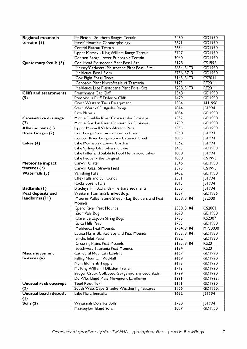
Regional mountain
terrains (5)
Mt Picton - Southern Ranges Terrain 2480 GD1990
Massif Mountain Geomorphology 2671 GD1990
Central Plateau Terrain 2684 GD1990
Upper Mersey - King William Range Terrain 2707 GD1990
Denison Range Lower Palaeozoic Terrain 3060 GD1990
Quaternary fossils (6) Coal Head Pleistocene Plant Fossil Site 2178 CS1996
Mersey/Cathedral Pleistocene Plant Fossil Site 2654, 3173 GD1990
Melaleuca Fossil Flora 2786, 3713 GD1990
Cox Bight Fossil Trees 3165, 3173 CS2011
Cenozoic Plant Macrofossils of Tasmania 3173 RE2011
Melaleuca Late Pleistocene Plant Fossil Site 3208, 3173 RE2011
Cliffs and escarpments
(5)
Frenchmans Cap Cliff 2348 GD1990
Precipitous Bluff Dolerite Cliffs 2479 GD1990
Great Western Tiers Escarpment 2504 AH1996
Scarp West of D’Aguilar Range 2814 JB1994
Eliza Plateau 3054 GD1990
Cross-strike drainage
(2)
Middle Franklin River Cross-strike Drainage 2352 GD1990
Middle Gordon River Cross-strike Drainage 2799 GD1990
Alkaline pans (1) Upper Maxwell Valley Alkaline Pans 2355 GD1990
River Gorges (2) First Gorge Structure - Gordon River 2358 JB1994
Gordon River Gorge above Cataract Creek 2805 JB1994
Lakes (4) Lake Morrison - Lower Gordon 2362 JB1994
Lake Sydney Glacio-karstic Lake 2483 GD1990
Lake Fidler and Sulphide Pool Meromictic Lakes 2808 JB1994
Lake Pedder - the Original 3088 CS1996
Meteorite impact
features (2)
Darwin Crater 2346 GD1990
Darwin Glass Strewn Field 2375 CS1996
Waterfalls (3) Vanishing Falls 2482 GD1990
Liffey Falls and Surrounds 2501 JB1994
Rocky Sprent Falls 2813 JB1994
Badlands (1) Bradleys Hill Badlands - Tertiary sediments 2525 JB1994
Peat deposits and
landforms (11)
Western Tasmania Blanket Bogs 2527 GD1996
Moores Valley ‘Stone Sheep - Lag Boulders and Peat
Mounds
2529, 3184 JB2000
Spero River Peat Mounds 2530, 3184 CS2003
Zion Vale Bog 2678 GD1990
Clarence Lagoon String Bogs 2725 KS2007
Spica Hills Peat 2793 GD1990
Melaleuca Peat Mounds 2794, 3184 MP20000
Louisa Plains Blanket Bog and Peat Mounds 2903, 3184 GD1990
Birchs Inlet Peats 2982 GD1990
Crossing Plains Peat Mounds 3175, 3184 KS2011
Southwest Tasmania Peat Mounds 3184 KS2011
Mass movement
features (6)
Cathedral Mountain Landslip 2657 GD1990
Falling Mountain Rockfall 2659 GD1990
Nells Bluff Slab Topple 2675 GD1990
Mt King William I Dilation Trench 2713 GD1990
Badger Creek Collapsed Gorge and Enclosed Basin 2789 GD1990
De Witt Island Mass Movement Landforms 2896 GD1995.
Unusual rock outcrops
(2)
Toad Rock Tor 2676 GD1990
South West Cape Granite Weathering Features 2906 GD1990.
Unusual beach deposit
(1)
Lake Flora hematite 2682 JB1994
Soils (2) Wayatinah Dolerite Soils 2720 JB1994
Maatsuyker Island Soils 2897 GD1990

Overview of geodiversity sites TWWHA – geological sites – gaps in the listings 8
Quaternary minerals (3) Pedra Branca Mineralogy 2914 GD1990
Adamsfield Workings Mineralogy 3051 GD1990
Reward Creek - Jane River Mineralisation 2706 GD1990
Cuestas (1) Stepped Hills Cuesta 3078 JB1995
Strike ridges (2) Prince of Wales Range Strike Ridge 2526 CS1996
Tiger Range Classical Fold Strike Ridge 3086 CS1996
TERTIARY
(7 = 2.4%)
Tectonic features (4) Macquarie Harbour Graben 2173 JB1994
Cloister Lagoon - Chapter Lake Fault Trace 2647 GD1990
Great Pine Tier Tertiary Fault Trace 2655 GD1990
Lake Edgar Fault 2784 GD1990
Basalts (3) Liawenee Hill Basalt Flows 2497 GD1990
Ibbotts Rivulet Basalt Jointing - near Lake Augusta 2642 GD1990
Knyvett Falls Basalt Flow 2940 GD1990
CRETACEOUS
(2 = 0.7%)
Rock types (2) Tasmanian Igneous Rocks of Cretaceous Age 2208 JB2010
Trappes Inlet Lamprophyre - Lake Gordon - age
unknown
3064 GD1990
JURASSIC
(7 = 2.4%)
Dolerite contacts (5) Mt La Perouse - Maxwell Ridge Dolerite Contact 2488 GD1992
Mt Gould Intrusive Contact 2650 GD1990
Mt Pelion East Dolerite Columns Imprint 2679 GD1992
South Cape Intrusive Contact 2922 GD1990
Mt Sarah Jane Dolerite Contact 3063 GD1990
Mineralisation (1) Mt Weld Crystal Caves 3024, 3045 CS2005
Jurassic basalts (1) Lune River Area Jurassic Basalts and Gemfield
Association
2548 CS1996
PERMIAN – TRIASSIC
(10 = 3.4%)
Rock type or sequence
(6)
Goulds Sugarloaf Parmeener Supergroup Section 2342 GD1990
Mt La Perouse - Moonlight Ridge Parmeener
Supergroup Exposures
2478 GD1990
The Temple Remnant Triassic Sandstone 2653 GD1990
Lake Will Oil Shale 2937 GD1990
Little Horn Late Palaeozoic Scree 2938 GD1990
Mt Inglis Permian Type Section 2939 GD1990
Unconformity surface
(3)
King William Saddle Palaeozoic Glaciated Surface 2705 GD1990
Barn Bluff - Mt Inglis Late Palaeozoic Glacial Valley 2935 GD1990
Lake Ellen Palaeozoic Surface 2936 GD1990
Structures (1) Moonlight Ridge Triassic Sedimentary Structures 2477 GD1990

Overview of geodiversity sites TWWHA – geological sites – gaps in the listings 9
DEVONIAN
(6 = 2.1%)
Minerals and
mineralisation (5)
Bubs Hill Quartz Crystal Locality 2338 GD1990
Commonwealth Creek Copper Workings 2648 GD1990
Oakleigh Creek Mine 2651 GD1990
Pelion Plains Copper Workings 2652 GD1990
Lindsay Hill Sulphide Vein - Joe Page Bay 2785 GD1990
Structure (1) Olga Syncline 2798 GD1990
SILURIAN DEVONIAN
(2 = 0.7%)
Fossils (1) Victoria Pass Graptolites 2372 JB1994
Type sections (1) Tiger Range Group Type Section 3087 CS1996
ORDOVICIAN
(8 = 2.7%)
Rock types, sequences
and type sections (7)
Bubs Hill Fossiliferous Limestone and Karst 2337 GD1990
Surprise Bay Deep-water Limestone 2916 GD1990
Precipitous Bluff Limestone Sequence and Karst 2481, 2562 GD1990
Precipitous Bluff Beds Type Section 2555 CS1996
New River Beds Type Section 2556 CS1996
Prion Beach Beds Type Section 2913 CS1996
Florentine Valley Formation Type Site 3059 GD1990
Fossil Localities (1) Marriott Hill Fossil Locality - near Adamsfield 3061 GD1990
CAMBRIAN
(16 = 5.3%)
Rock types and
sequences (5)
Huon River Cambrian Turbidites - not actually within
TWWHA
2560 CC2005
Mewstone Granite - unknown age 2909 GD1995
Adamsfield Open Cut Palaeoplacer 3049 GD1990
Adamsfield - Serpentinite Creek Ultramafics 3050 GD1990
Denison Range Flysch Sequence 3069 GD1990
Unconformities (4) Elliott Range Palaeozoic Unconformity 2341 GD1990
Mt McCutcheon Palaeozoic Unconformity 2343 GD1990
Mulcahy Bay Unconformity 2895 GD2005
Denison Gap Unconformity 3053 GD1990
Structures (4) Clytie Cove Sedimentary Structures 2783 GD1990
De Witt Island Folding 2901 GD1995
Osmiridium Beach Shear Zone 2920 GD1990
Point Vivian Sedimentary Structures 2923 GD1990
Fossil localities (3) Flagstone Knoll Cambrian Fossils 3055 GD1990
Junction Hill Cambrian Fossils 3058 GD1990
Trial Ridge Cambrian Fossil Locality 3065 GD1990

Overview of geodiversity sites TWWHA – geological sites – gaps in the listings 10
PRECAMBRIAN
(31 = 10.6%)
Rock types Tyennan
Mesoproterozoic (12)
Bills Creek Eclogite 2336 GD1990
Cardigan Flats Schist 2339 GD1990
Collingwood River White Schist 2340 GD1990
Mt Arrowsmith - Scotchfire Metamorphics 2719 JB1994
Bond Bay Schist 2883 GD1990
Nye Bay Mylonite Zone 2885 GD1990
Payne Bay Dolerite 2886 GD1990
Trumpeter Islets Porphyroblasts 2887 GD1990
Maatsuyker Island ‘Ribbon Rock’ 2898 GD1995
Wilson Bight Schist 2908 GD1990
Atkins Range Ironstone 3052 GD1990
White Spur Clastic Dykes - Lake Gordon area 3068 GD1990
Rock types and type
sections
Neoproterozoic (14)
Blakes Opening Agate in Precambrian Dolomite - age
uncertain
2549 CS1996
Huon River Neoproterozoic Glacigenic Rocks 2561 CC2005
Humboldt Divide Stromatolite-bearing Dolomite
Locality
3056 GD1990
Upper Weld Valley Mixtite - Dolomite Association 3066 GD1990
Annakananda Formation Type Section 3089 CS1996
Gomorrah Dolomite Type Section 3091 CS1996
Lake Judd Formation Type Section 3092 CS1996
Lake Timk Formation Type Area 3093 CS1996
Lonely Tarns Formation 3094 CS1996
Sarah-Jane Quartzite Type Section 3095 CS1996
Scotts Peak Road Member 3096 CS1996
Styx Dolomite Type Section 3097 CS1996
Twin Creeks Formation Type Section 3098 CS1996
Devils Eye Dolomite Type Area 3099 CS1996
Structures (2) Raglan Range Precambrian Fold Hinge 2345 GD1990
Wallaby Bay Remnant Sedimentary Structures 2888 GD1990
Regions (2) Jubilee Region 3025 GD1990
Tyennan Region 3080 GD1990
Unconformities (1) Mt Anne Precambrian Unconformity 3062 GD1990
COMMENTS ON THE GROUPINGS AND SITES
1. Quaternary/Recent sites
Some 203 of the 291 TWWHA sites, or 70%, represent geomorphological features. This
reflects the great diversity of landscapes and processes within the TWWHA, with a large
range of important glacial (47 sites), fluvial (19), coastal (45), karst (22) and other landforms
present. It probably also reflects the preponderance of specialist interests within the group
involved in developing and maintaining the geoconservation database, but this is not seen as
a negative factor. There are many important sites, a lot of research has been done, and the
sites must stand on their individual merit. Some general and detailed comments on the sites
follow.
Overview of geodiversity sites TWWHA – geological sites – gaps in the listings 11
Although there are 13 glacial regions listed, it is perhaps surprising that Schnells Ridge is not
listed, considering the important recent dating work on erratic moraine boulders which has
been done there (Kiernan et al, 2004).
The Regional Mountain Terrains site ‘Upper Mersey King William Range Terrain’ (2707)
includes much of the headwater country of the Forth, Murchison, King, Franklin and
Derwent Rivers, as well as the Mersey. It is separated into two areas, has considerable
overlap with the ‘Central Highlands Cainozoic Glacial Area’ (2953) and ‘Central Plateau
Terrain’ (2684), but seems to have little in the way of unity or integrity to justify its
nomination. It is recommended that it be removed. The justification for such large sites
generally needs to be carefully considered, since they may only be warranted where there
are clear boundaries and a strong internal consistency.
The ‘Cliffs and Escarpments’ grouping seems to be a rather random selection, with
Frenchmans Cap (2348) represented but not Federation Peak, and several dolerite
escarpments (Precipitous Bluff, Great Western Tiers) but not such places as Eldon Bluff, Traveller Range, Mt Olympus, Mt Geryon, The Acropolis, etc. This seems to demonstrate a
degree of arbitrariness in the selection of such sites.
Similarly, the ‘River Gorges’ group has two sites, both from the Gordon River (First Gorge
and the Lower Gordon Gorge), but doesn’t include the Dove River Gorge (a spectacular
quartzite gorge nowdays used for canyoning), Franklin Gorge, the Gordon Gorge at The
Thumbs, the Anne River Gorge etc. The question of what constitutes a listable gorge site
needs to be considered. Different types of geology transected should perhaps be a factor.
Similarly for ‘Lakes’ - four lakes are nominated (Lake Morrison and Lake Fidler on the Lower
Gordon, Lake Sydney, and the original Lake Pedder). But many of our other lakes could be
equally important and special - Lake Rhona, Lake Curly, Lake Judd, Lake Oberon, Crater
Lake, Lake Will etc. Are lakes really geodiversity sites, and what criteria should be applied in
selecting them for nomination?
Similar considerations apply to the selection of sites for the ‘Waterfalls’, ‘Mass Movement
Features’, ‘Strike Ridges’ and ‘Unusual Rock Outcrops’ categories.
One category not represented but which is worthy of consideration is Lightning Strike sites.
Two such sites known to the author, at Little Plateau near Cradle Mountain, and at Mt Sarah
Jane, are of considerable interest in demonstrating the power of lightning to move and
shatter rocks, and to produce ground features related to steam flashing.
2. Tertiary sites
The seven sites include four which are based on significant Tertiary fault structures which
have a clear surface expression (Macquarie Harbour Graben, Cloister Lagoon - Chapter
Lake Fault Trace, Great Pine Tier Tertiary Fault Trace, Lake Edgar Fault) and three sites
based on basalt lava flow features (Liawenee Hill, Ibbotts Rivulet near Lake Augusta, and
Knyvett Falls). All seem reasonably well based.

Overview of geodiversity sites TWWHA – geological sites – gaps in the listings 12
3. Cretaceous sites
The one main site is based on a lamprophyre dyke exposed on the Gordon River Road at
Trappes Inlet (3064), with an assumed Cretaceous age. This rock has not been dated,
however, and its inclusion seems unwarranted. Most of the lamprophyres in Western
Tasmania once assumed to be Cretaceous have been found, after dating, to be of Devonian
age.
4. Jurassic sites
Although a large portion of the TWWHA is occupied by Jurassic dolerite, it is not unreasonable to find only seven Jurassic sites, since the extensive dolerite displays few
variations of interest. Five of the sites relate to dolerite basal contacts, typically on rocks of
the Parmeener Supergroup. The dolerite contact on Precambrian quartzite which is well
exposed on the eastern flank of Cradle Mountain, and similar contacts against Precambrian
rocks at Mt Anne-Mt Eliza, should also be considered.
5. Permian - Triassic sites
Permian - Triassic rocks are widespread within the TWWHA. The ten listed sites,
comprising six rocks/sequences, three unconformity surfaces and one for sedimentary
structures, appear justified, and generally reflect those areas where work has been done on
the sequences. Some additional sites may be identifiable in the Pyramid Mountain - Rocky
Hill area, after work on the Lyell Sheet (Calver et al, 1987).
6. Devonian sites
Five of these six sites are for mineral occurrences or old mines. The Bubs Hill Quartz
Crystal site (2338) entry lacks any detailed information and seems of dubious value,
considering there are very many sites where such crystals are collected (R.S. Bottrill, pers.
comm.). The other four sites - Commonwealth Creek, Oakleigh Creek, Pelion Plains and
Lindsay Hill - all relate to relatively small occurrences of temporarily commercial minerals,
probably of Devonian age, in Precambrian host rocks. Considering how many such small old
workings there are around Tasmania (many hundreds), most of which have not been
considered for inclusion in the geoconservation database, it would seem that a good
argument needs to made that each site is of sufficient interest or uniqueness to warrant
inclusion. It would appear to require more than just the fact that they occur within the
TWWHA?
The Olga Syncline site (2798) is included as a classic Devonian fold structure, which it is.
The faulted eastern boundary of the structure should be noted, however. The Tiger -
Gordon Range synclinal structure is somewhat similar, but is listed in the Quaternary
landscapes as the Tiger Range Classical Fold Strike Ridge site (3086).
7. Silurian - Devonian sites
Only two sites are listed, for the Victoria Pass Graptolites (2372) and the Tiger Range
Group Type Section (3087). The author is not aware of other possible sites.
8. Ordovician sites
Ordovician siliciclastic sequences and overlying limestone sequences are important
components of the TWWHA geology, mainly preserved in large Devonian synclinal folds,

Overview of geodiversity sites TWWHA – geological sites – gaps in the listings 13
e.g. the King – Franklin – Gordon - Olga area, the Rasselas Denison Range area, and the
New River area. The siliciclastic units generally sit on top of Late Cambrian rocks of similar
type, making up the Denison Group, and tend to be included in Cambrian sites, e.g. the
Denison Range Flysh Sequence (3069). There are places, however, where only Ordovician
rocks are present beneath the limestone e.g. western side of Olga Syncline, Giblin Syncline,
and there is a good case for recognition of one or more sites representative of this
situation.
There are seven sites representing the limestone sequences, mainly from the South Coast -
Precipitous Bluff area, with one at Bubs Hill and one on the TWWHA boundary at
Florentine Valley. One Ordovician fossil locality, near Adamsfield, has been recognised.
9. Cambrian sites
Although most of the state’s Cambrian rocks- particularly the Mt Read Volcanics belt - lie
outside the TWWHA, important sequences are found on the South Coast east of New
River, in the Ironbound Range area, at Bathurst Harbour, in a few small areas around the
Weld River, and in the Adamsfield - Mt Wedge - Denison Range area. Although the West
Coast Range site appears on the list of TWWHA sites, it is essentially outside, and is not
considered here. The Huon River Cambrian Turbidites (2560) site touches the TWWHA
boundary at its western end, but is essentially outside the TWWHA.
Of the 15 remaining sites, five are rock units or sequences, four are ‘structures’ (two
tectonic and two sedimentary), four are unconformities, and three are fossil localities.
Excluding the unconformities, there are four sites from the South Coast and islands, one
from the Bathurst Harbour sequence, and six from the Adamsfield - Denison Range area.
There are no sites listed for the Ironbound Range sequence, perhaps reflecting the lack of detailed study.
The Mewstone Granite site (2909) is considered dubious, as the granite has not been dated
(best guess by J. Everard, pers. comm., is Cambrian) and does not appear to have any special
characteristics.
The De Witt Island Folding site (2901) is based on the tectonic folds seen in this very well
exposed proximal flysch sequence, but it would seem better to include the rock sequence as
a whole, since the sedimentary features (massive to graded conglomerate beds interbedded
with siltstones and graded sandstones with a variety of structures) and compositional
characteristics are also of considerable interest and value.
This also applies to the Point Vivian Sedimentary Structures site (2923), which has been
nominated on the basis of the well-exposed sedimentary structures but would be better
expanded, or re-worded, to encompass the formation as a whole.
It is similarly recommended that the Osmiridium Beach Shear Zone site (2920), nominated
for the tectonic structure, should be expanded to encompass the unusual serpentinite-
bearing multi-coloured conglomerates and sandstones of the Tyler Creek Beds within which
the shear zone is located. The cliffs of these rocks are an impressive feature of Osmiridium
Beach, and the formation is important on a state-wide basis.
Overview of geodiversity sites TWWHA – geological sites – gaps in the listings 14
Similar comments apply to the Clytie Cove Sedimentary Structures site (2783), in Bathurst
Harbour, which would be better named the Clytie Cove Group Flysch Sequence to
encompass all the important aspects of the rocks.
The area encompassed by the ‘Denison Range Flysch Sequence’ site (3069) includes the
shallow marine Great Dome Sandstone lying above the Singing Creek flysch formation, and
the Reeds Conglomerate fluvial formation lying above this again, so that the name is
misleading. It is desirable to have the full sequence represented, since it is the best exposure
of the flysch to non-marine transition in Tasmania, and has been the subject of several
research papers. I suggest it be re-named the ‘Denison Range Flysch - Paralic - Fluvial
Sequence’, and that references to papers on the slump sheets and thick-bedded sandstones
be added (Corbett, 1972, 1973).
Three Cambrian fossil locality sites (Flagstone Knoll, Trial Ridge, Junction Hill) have been
nominated, but it would be desirable to add the two important Late Cambrian sites from
the South Coast, i.e. the Powena Beds at Point Cecil, with abundant trilobites, and the younger Wierah Formation at Prettys Point, also with trilobites. The fossil descriptions have
been updated by J.R. Laurie (Laurie, 1996), and field descriptions of the rocks are given by
Berry and Harley (1983) and Bischoff (1983).
10. Precambrian sites
Precambrian rocks are by far the most abundant type within the TWWHA, making up over
50% of the total area. Most of the rocks are of the metamorphosed Mesoproterozoic
Tyennan type, but there is also a fair proportion of younger, relatively unmetamorphosed,
Neoproterozoic sequences, with dolomitic units prominent, particularly in the Jubilee
Region.
Of the 31 Precambrian sites, 12 are rock units of the Mesoproterozoic Tyennan type, 16 are
rock units and type sections from the Neoproterozoic, two are regions (Tyennan and
Jubilee), two are structures, and one is an unconformity.
The Jubilee Region site (3025) seems difficult to justify, since this refers to an area where
the younger Precambrian rocks are exposed, in somewhat scattered fashion through cover
rocks, east of the Tyennan Region. It seems likely that the same sequences are present
beneath the younger cover up the eastern flank of the Tyennan block to the north, and that
there is some connection to the same sequences in the north west of the state. It seems
unlikely that the area represents any sort of tectonic or palaeogeographic entity (unlike the
Tyennan Region, which was a tectonic entity during the Tyennan Orogeny, and a
palaeogeographic high during the Late Cambrian) and the author recommends that it be
removed.
The Tyennan Region site (3080) needs to be updated to include the Cradle Mountain
section of the region, which is generally accepted as an integral part of it.
The ‘Trumpeter Island Porphyroblasts’ site (2887) should be re-named as the Trumpeter
Island Porphyroblastic Schist.
The Maatsuyker Island ‘Ribbon Rock’ site (2898) seems dubious, as such banded schists and
phyllites are not uncommon, e.g. there are good examples at Dove Lake.

Overview of geodiversity sites TWWHA – geological sites – gaps in the listings 15
The Atkins Range Ironstone site (3052) is based on small outcrops of schist with specular
hematite aligned on a cleavage. The origin of these has not been investigated, but it seems
they are not like the prominently banded chemical iron stones of the Pilbara and elsewhere,
which seems to be implied in their recognition as worthy of nomination?
The ‘Wallaby Bay Remnant Sedimentary Structures’ site (2888) needs to have a proper
reference citation (Williams, 1982).
GENERAL CONCLUSIONS AND CONSIDERATIONS
1. The high proportion of Quaternary/Recent sites (70%) seems to be mainly a reflection
of the great variety of geomorphological features preserved in the TWWHA. However,
there appears to be a degree of randomness involved in the selection of some sites.
2. No glaring gaps have been identified in the listings from the older rock units - partly a
reflection of the fact that most of these units are better represented outside the
TWWHA. However, some possible additional sites from areas within the TWWHA
have been suggested.
3. Attention is drawn to some sites which do not appear to be justified or sufficiently
clearly argued.
4. There would appear to be a need for a careful overview of sites, both within the
database and when they are being nominated, to ensure that the nominations are
sensible, clearly justified, properly documented and not overlapping or ambiguous. It
seems to be necessarily the case that nearly all sites are nominated by members of the
Tasmanian Geoconservation Database Reference Group - the same group responsible
for vetting the nominations - and it is suggested that an informal ‘devil’s advocate’ role
within this group might be worthwhile.
5. The author sees a need for information about the sites, or at least the important and
more visually impressive ones, to be made more accessible to the general public. At the
moment there is a fairly difficult, computer-based process involved in accessing
information about our important geological sites. This process requires a password to
be allocated by the Natural Values Atlas group, and is thus basically unavailable to the
interested layman. Even if accessed, there are few images of the features involved to
show what they look like.
If we have such an array of wonderful geodiversity sites, on a world scale, shouldn’t we
make something of this available to all those who have ownership of our wilderness
areas - not keep it within a small ‘elite’ group, and use it basically for administrative
purposes, as is essentially the case at the moment? The original small book on

Overview of geodiversity sites TWWHA – geological sites – gaps in the listings 16
‘Geological Monuments in Tasmania’, produced by the Geological Society of Australia
Tasmanian Division in 1979, was the last time the general public was able to see what
Tasmania had in the way of important geological features. This book dealt with 60 sites
outside the National Parks, and was state-wide in coverage. Any update would probably
also need to be state-wide.
I believe it should be possible to distil a manageable number of the best sites from the
very large inventory now available, and present them to the public in an easily accessible
form, with images and explanations, so that all can appreciate something of our world-
class geological heritage.
REFERENCE LIST Berry, R.F. and Harley, S. (1983). Pre-Devonian stratigraphy and structure of the Prion
Beach – Rocky Boat Inlet – Osmiridium Beach coastal section, southern Tasmania. Papers & Proceedings Royal Society Tasmania 117, 59-75.
Bischoff, K. (1983). The geology of the Rocky Boat Inlet – Surprise Bay area. B.Sc. Honours
thesis, University of Tasmania.
Calver, C.R., Baillie, P.W., Everard, J.L., Seymour, D.B., Williams, P.R., Forsyth, S.M., Turner,
N.J. and Williams, E. (1987). Lyell, Tasmania. Geological Atlas 1:50,000 Series
Geological Map. Tasmania Department of Mines.
Corbett, K.D. (1972). Features of thick-bedded sandstones in a proximal flysch sequence,
Upper Cambrian, south-west Tasmania. Sedimentology 19, 99-114.
Corbett, K.D. (1973). Open-cast slump sheets and their relationship to sandstone beds in an
Upper Cambrian flysch sequence, Tasmania. Journal Sedimentary Petrology 43, 147-
159.
Kiernan, K., Fifield, L.K. and Chappell, J. (2004). Cosmogenic nuclide ages for Last Glacial
Maximum moraine at Schnells Ridge, Southwest Tasmania. Quaternary Research 61
(3), 335-338.
Laurie, J.R. (1996). Macrofossils from the Wierah Formation and Powena Beds, South Coast,
Tasmania. Professional Opinion Paper 1996/011, Australian Geological Survey
Organisation.
Williams, P.R. (1982). Sheet 91 Davey. Geological Survey Explanatory Report, Department of
Mines Tasmania.