Geodiversity Audit & Action Plan for the Causeway Coast & Glens
123
Geodiversity Audit & Action Plan for the Causeway Coast & Glens Region April 2013 William Burke
Transcript of Geodiversity Audit & Action Plan for the Causeway Coast & Glens

Geodiversity Audit &
Action Plan for the
Causeway Coast & Glens
Region
April 2013 William Burke

1
Acknowledgements This document has been produced with the help of many individuals and organisations who have contributed to the process by offering advice, information, the use of their facilities and documents and invaluable comments on drafts. The authors are grateful to the following: Staff at the Causeway Coast and Glens Heritage Trust; Northern Ireland Environment Agency; Geological Survey NI; the National Trust; Queens University, Belfast; University of Ulster; Officers from Limavady, Coleraine, Ballymoney, Ballymena, Moyle and Larne District Councils, Western Education and Library Board, North Eastern Education and Library Board and for all the others who have contributed information and provided assistance.

2
TABLE OF CONTENTS 2 LIST OF FIGURES AND TABLES 4 PART 1 INTRODUCTION TO GEODIVERSITY 1.0 Introduction 1.1 Scope of the Report 6 1.2 Structure of the Report 6 1.3 Study area 7 1.4 Defining Geodiversity 8 1.5 The Relevance of Geodiversity 9 1.6 Conserving Earth Science in the CCGHT area – Strategic Considerations and Designations 10 1.6.1 Regional Development Strategy 10 1.6.2 Northern Area Plan 2016 10 1.6.3 Causeway Coast & Glens Tourism Masterplan 2004-2013 10 1.6.4 Causeway Coast & Glens Tourism Area Plan 11 1.6.5 Earth Science Conservation Review 11 1.6.6 Areas of Outstanding Natural Beauty 11 1.6.6.1 Antrim Coast and Glens AONB 12 1.6.6.2 Causeway Coast AONB 12 1.6.6.3 Binevenagh AONB 13 1.6.7 World Heritage Site Designation 13 1.6.8 Areas of Special Scientific Interest 13 1.6.9 Special Aras of Conservation 14 1.6.10 Special Protection Areas 14 1.6.11 National Nature Reserves 14 1.6.12 Local Nature Reserves 14 PART 2 THE GEODIVERSITY OF THE CAUSEWAY COST AND GLENS 2.0 Background to the Geological and Geomorphological History 2.1 Introduction to the Geological Basement of Ireland 15 2.2 Geology of Northern Ireland 17 2.3 Geological Evolution of the Causeway Coast and Glens area 20 2.3.1 Precambrian Period 24 2.3.2 Devonian Period 27 2.3.3 Carboniferous Period 30 2.3.4 Triassic Period 33 2.3.5 Jurassic Period 35 2.3.6 Cretaceous Period 38 2.3.7 Palaeogene Period 43 2.3.8 Quaternary Period 50 2.4 Intrusive Igneous Rocks 54 2.4.1 Plugs 54 2.4.2 Sills 56 2.5 Landforms 58 2.5.1 Glacial Landforms 58 2.5.2 Coastal Landforms 60 2.5.3 Slopes 62 2.6 Soils 65 2.7 Fossils and Palaeontology 66 2.8 Minerals and Mineralogy 67

3
2.8.1 Industrial Minerals 67 2.8.2 Mineral Site Examples 67 3.0 Importance of the area in the development of geological science 69 4.0 Assessment of Key Sites of Geodiversity Interest 4.1 Factors contributing to site Selection 73 4.1.1 Economic Value and Tourism Potential 73 4.1.2 Access Conditions and Recreational Opportunities 74 4.1.3 Geoconservation Challenges and Opportunities 74 4.1.4 Education and Learning Opportunities 75 4.2 Site Register 77 4.3 Description of Key Geodiversity Sites of Importance 83 4.3.1 Torr Head 83 4.3.2 Fairhead to Murlough Bay 83 4.3.3 Cushendall to Waterfoot 84 4.3.4 Cushendun 84 4.3.5 Ballycastle Coalfield 84 4.3.6 Waterloo Foreshore, Larne 85 4.3.7 Portrush Sill 85 4.3.8 White Park Bay 85 4.3.9 White Rocks, Portrush 86
4.3.10 Ballintoy 86
4.3.11 Giant’s Causeway 86 4.3.12 Rathlin Island 87 4.3.13 Carrickarede 87 4.3.14 Slemish Mountain 87 4.3.15 Binevenagh 88 4.3.16 Portballintrae 88 4.3.17 Magilligan Foreland 88 5.0 Connections with landscape and biodiversity, built and cultural heritage 5.1 Geodiversity Connections with local Biodiversity 89 5.2 Geodiversity connections with the Built Heritage 91 5.3 Geodiversity connections with the Extractive Industries and Quarrying 92 5.4 Geodiversity connections with the Cultural Heritage 93 5.4.1 Myth and Folklore 93 5.4.2 Industrial Heritage 93 5.4.3 Painting, Art and Photography 93 References and Bibliography 94 PART 3 ACTION PLAN 6.0 Causeway Coast and Glens Geodiversity Action Plan 6.1 Introduction 99 6.2 Stakeholders 99 6.3 Action Plan 100
APPENDICES 115

4
LIST OF FIGURES Figure 1: Map of Northern Ireland showing the location and extent of the Causeway Coast and Glens Geodiversity Audit. Figure 2: Map of Ireland illustrating the geological Terranes Figure 3: The rocks of Northern Ireland Figure 4: Map showing the simplified geology of the Causeway Coast and Glens area Figure 5: Map showing the Dalradian Geology of the Causeway Coast and Glens area Figure 6: Torr Head Limestone overlying the younger Altmore Formation Psammite beds. Figure 7: Map showing the Devonian Geology of the Causeway Coast and Glens area Figure 8: Sandstone Conglomerate at Cushendun Figure 9: Conglomerate beds and coarse sandstones at Cushendall Figure 10: Pink – Red pebbly sandstone of the Red Arch Formation, Cushendall. Figure 11: Map showing the Carboniferous Geology of the Causeway Coast and Glens area Figure 12: Coal bearing strata at Ballycastle Figure 13: Coal Mine entrance at Ballycastle Figure 14: Map showing the Triassic Geology of the Causeway Coast and Glens area Figure 15: Map showing the Jurassic Geology of the Causeway Coast and Glens area Figure 16: The rocks at Waterloo Bay looking at the boundary between the Triassic and Jurassic periods. Figure 17: Mudslide at Minnis North Figure 18: Map showing the Cretaceous Geology of the Causeway Coast and Glens area Figure 19: Tilted blocks of chalk on the west side of White Park Bay showing successive chalk members Figure 20: Raised Beach Caves, Stacks and Arches at Ballintoy Figure 21: Cretaceous Rocks at Whiterocks, Portrush Figure 22: Ulster White Limestone Members overlain by Basalt at Portrush Figure 23: Map showing the Palaeogene Geology of the Causeway Coast and Glens area Figure 24: Geological succession at the Giants Causeway covers the Lower and Middle Basalts and the lower of the two Inter-basaltic Beds of the Antrim Lava Group Figure 25: Lower Basalts at Windy Gap Figure 26: Colonnade/entablature junction at ‘The Organ’ Figure 27: The Giants Causeway Figure 28: Carrickarede volcano, now an island. This volcano erupted through the chalk during the initial explosive stage of igneous activity in Antrim Figure 29: Carrickarede vent agglomerate, weathered to red laterite with basalt boulders Figure 30: Binevenagh cliffs showing the presence of extensive slipped masses of basalt overlying Cretaceous, Liassic and Triassic rocks Figure 31: Glacio emergent sequence at Portballintrae consisting of glaciomarine diamict, shallow marine sands and muds overlain by shoreface gravels. Figure 32: Magilligan Dune System Figure 33: Slieveanorra and Croaghan Blanket Bog Figure 34: Slemish Mountain Figure 35: Tievebulliagh Mountain Figure 36: Scwat Hill Limestone – Dolerite contact zone Figure 37: Fair Head Sill Figure 38: Layered hornfels (baked mudstone) on top of Portrush sill. Figure 39: U shaped valley of Glenariff Figure 40: Carey Valley Delta Figure 41: Distribution of selected glacial geologic features and the position of the Armoy moraine Figure 42: Examples of Cliff, shore platform, cave, arch, and sea stack found at the Whiterocks Figure 43: Raised rock coast landforms at Ballintoy

5
Figure 44: Principal Areas of Landslides around the Basalt Plateau Figure 45: Rotational Landslide (Basalt over Chalk) at Garron Point, Coast Road Figure 46: Debris Flow at the Giant’s Causeway Figure 47: Rockfall on the Antrim Coast Road Figure 48: The “Neptunist” Abraham Gottlob Werner and the “Plutonist” James Hutton Figure 49: Lias shales containing Ammonites subjected to hornfelsing by intrusive rocks Figure 50: The Giant’s Causeway (Rev William Hamilton 1786) Figure 51: Sketch from Bald’s report to the Commissioners of Public Works in 1834. LIST OF TABLES Table 1: Geological Timescale illustrating the geological history of N. Ireland Table 2: Geological Timescale illustrating the geological history of the Causeway Coast and Glens Table 3: The currently accepted classification of the Precambrian Rocks of the CCGHT area Table 4: Currently Protected sites containing Precambrian Rocks Table 5: The currently accepted classification of the Devonian Rocks of the CCGHT area Table 6: Currently Protected sites containing Devonian Rocks Table 7: The currently accepted classification of the Carboniferous Rocks of the CCGHT area Table 8: Currently Protected sites containing Carboniferous Rocks Table 9: The currently accepted classification of the Triassic Rocks of the CCGHT area Table 10: The currently accepted classification of the Jurassic Rocks of the CCGHT area Table 11: Currently Protected sites containing Jurassic Rocks Table 12: The currently accepted classification of the Cretaceous Rocks of the CCGHT area Table 13: Currently Protected sites containing Cretaceous Rocks Table 14: The currently accepted classification of the Palaeocene Rocks of the CCGHT area Table 15: Currently Protected sites containing Palaeocene Rocks Table 16: The currently accepted classification of the Quaternary and Holocene deposits of the CCGHT area Table 17: Site Register

6
PART 1: AN INTRODUCTION TO THE CONCEPT OF GEODIVERSITY 1.0 Introduction 1.1 Scope of the Report In 2012 the Causeway Coast and Glens Heritage Trust (CCGHT) was awarded funding from the Northern Ireland Environment Agency (NIEA) to undertake a Geodiversity Audit and Action Plan for the Limavady, Coleraine, Ballymoney, Ballymena, Moyle and Larne Council areas focusing especially upon the geological heritage within the boundaries established by the Antrim Coast and Glens, Causeway Coast and Binevenagh Areas of Outstanding Natural Beauty (AONB). In February 2013, CCGHT commissioned Dr William Burke and Associates to produce a Geodiversity Audit and Action Plan that would contribute to the delivery of key projects and relevant management plans within the setting of the Giant’s Causeway and Causeway Coast World Heritage Site, three local AONBs and the Heart of the Glens Landscape Partnership area. The objectives of the audit and action plan were to:
(a) Provide information on the geological and geomorphological history of the area and its relevance to the Giant’s Causeway World Heritage Site and the wider Causeway Coast and Glens Landscape.
(b) Highlight the importance of the area in the development of geological science (c) Identify key sites of geodiversity interest, including an assessment of their:
i. Economic value and tourism potential ii. Access conditions and recreational opportunities iii. Geoconservation challenges and opportunities iv. Education and learning opportunities v. Current site use
(d) Illustrate any geological connections with landscape and biodiversity, built and cultural
heritage (e) Provide a Specific, Measurable, Achievable, Realistic, Time-Limited (SMART) action plan based
upon objectives relevant to existing and future plans and strategies which would highlight lead and supporting partners, timescales and estimated costs.
1.2 Structure of the Report The structure and content of this Audit and Action Plan is based upon the framework established by the UK Geodiversity Action Plan1 which provides a shared context and direction for geodiversity action through a common aim, themes, objectives and targets which link national, regional and local activities. This approach has been developed and agreed through wide consultation and dialogue across England, Scotland, Wales and Northern Ireland between organisations, groups and individuals currently involved in geodiversity. Part 1 of the report serves as an introduction to the concept of geodiversity and in particular its relevance and application in the Causeway Coast and Glen’s area. Part 2 is a detailed evaluation of the area’s geodiversity focusing on objectives (a) to (d) outlined above
1 The UK Geodiversity Action Plan provides a framework in which actions for geodiversity can be captured in one place allowing a range of organisations, groups and individuals to demonstrate their achievements in a UK-wide context. Further information can be obtained from www.ukgap.org.uk.

7
Part 3 provides a detailed action plan, building upon the findings of the audit, which defines the long term objectives and short term targets for conserving and making best use of the available geodiversity resources. The Action Plan will link with strategic objectives of other agencies and discuss opportunities for utilising the geodiversity resource of the Causeway Coast and Glens Heritage Trust catchment area in terms of economic, geoconservation and educational actions. 1.3 Study Area The setting for the Geodiversity Audit is geographically defined as the Causeway Coast and Glens which covers the Limavady, Coleraine, Ballymoney, Ballymena, Moyle and Larne Council areas. More specifically, the Audit will concentrate on the geological heritage within the boundaries established by the Antrim Coast and Glens, Causeway Coast and Binevenagh Areas of Outstanding Natural Beauty (figure 1) and the Giant’s Causeway and Causeway Coast World Heritage Site. In consultation with Council partners, sites outside the AONB boundaries will also be examined and included in the Audit. The southern portion of the study area boundary extends from Larne northwards along the east coast of Northern Ireland to include Ballygally, Glenarm, Garron Point, Cushendall, Torr Head and Ballycastle and extending inland to incorporate the Glens of Antrim. From here it proceeds west past Benbane Head and the Giants Causeway and Causeway Coast World Heritage Site (WHS), across to Portrush and Portstewart continuing west past Castlerock and terminating at Magilligan Point and the Binevenagh escarpment. In total, the Audit area covers approximately 93,000 ha.
Figure 1: Map of Northern Ireland showing the location and extent of the Causeway Coast and Glens Geodiversity Audit.

8
1.4 Defining Geodiversity Geodiversity has been defined as “the link between people, landscape and their culture: it is the variety of geological environments, phenomena and processes that make those landscapes, rocks, minerals, fossils and soils which provide the framework for life on earth” (Stanley, 2001), or as “geological diversity or the variety of rocks, fossils and minerals and natural processes” (Prosser, 2002). Highlighting a key element in Stanley’s definition, Burek (2001) commented that “Geodiversity underpins biodiversity” and offered a further definition of geodiversity as “the abiotic factors, which together with biodiversity give a holistic view of the landscape” (Burek, 2002). Geodiversity is a key component of an area’s natural heritage. A vital starting point is an appreciation of the most up to date available understanding of the area’s geological deposits and features, together with the processes and phenomena which have formed them and continue to influence them. An area’s geodiversity encompasses:
The historical legacy of research within the area
Sites or features at which representative examples of the areas geological deposits and features may be seen
Sites or features which are deemed worthy of some form of designation or protection for the quality of earth science features displayed
The whereabouts and nature of past and present working of mineral products
Sites and features currently employed in interpreting earth science
The influence of earth science in shaping the built and man-made environment
Material collections and site records
Published literature and maps
The inter-relationship and inter-dependence between earth science and other interests Following the UK government’s ratification of the UN Convention on Biological Diversity, which resulted from the Rio Earth Summit in 1992, and the production in 1995 of the UK Biodiversity Steering Group’s Report Meeting the Rio Challenge, subsequent years have seen the preparation and implementation of Biodiversity Action Plans for most parts of the UK. Biodiversity is now accepted as an essential element in sustainable planning and management strategies. Geodiversity however, is a newer term and its increasing use testifies to the increasing awareness within the United Kingdom and Ireland as to the equal importance of understanding and conserving our geodiversity. Geodiversity provides a foundation for modern society and all of our lives. It provides natural resources, such as building stones, aggregates, minerals and metals; it harbours natural gas, oil and groundwater; it forms the basis of all our productive soils and agricultural land; it influences where we live; it gives rise to our spectacular and valued landscapes; provides an irreplaceable archive of past climatic and environmental conditions, as well as the rich cultural heritage and history of mineral extraction, and is the basis of our natural environment. Without geodiversity there is no biodiversity. It is a common misconception that geological and landscape features, other than those already afforded some measure of protection as Areas of Special Scientific Interest (ASSIs), are sufficiently robust not to require active management or action planning. All geological features are potentially vulnerable. In addition to obvious threats posed by inappropriate site development and the infilling of quarries, the encroachment of vegetation, natural weathering and general deterioration with time may threaten to damage or obliterate important geological features. This situation would not be tolerated in wildlife or archaeological sites of comparable scientific or educational value. However, geodiversity is not, or should not be, regarded merely as concerned with conservation of geological sites or features. As an essential part of natural heritage it influences fields as varied as economic

9
development and historical and cultural heritage. It might at first seem hard to conceive of threats to rocks and landscapes that have endured for millennia and that geodiversity hardly needs active conservation and management. However, the geodiversity of the Causeway Coast and the three designated AONBs is subject to a range of activities – tourism, quarrying past and present, rural development, land-fill, waste disposal, road building and other issues, for example wind farms that may affect the landscape. Unlike biodiversity, once an important rock sequence or glacial landform has been destroyed, it can never be recreated. 1.5 The Relevance of Geodiversity Geodiversity is fundamental to almost every aspect of life – all raw materials that cannot be grown and all energy that cannot be generated by renewables have to be found using geological science. A clear understanding of geology is also vital to the design and location of buildings, roads, railways and airports as well as to the safe control of waste disposal, and the management of a wide range of natural and man-made natural hazards. All are aspects of geodiversity. An awareness of geodiversity helps us to understand our environment and predict environmental change in the future. Geological research demonstrates that surface environments are continually evolving through natural self-regulating systems involving the Earth’s crust and mantle, oceans, atmospheric processes and life forms. Human activity imposes further pressures and changes to these natural cycles which pose great challenges to modern society. Exhaustion of finite resources such as fossil fuel and global climate change are two of the most pressing. Only by studying the geological record can we hope to predict the Earth’s response to these changing conditions. The recognition of natural and cultural heritage features and their sustainable management are today accepted as important functions within a civilised society. The importance of the range and diversity of Earth heritage features – the ‘geodiversity’ - of any area is as important a facet of its natural heritage as its wildlife interests. Conservation, sustainable management, educational use and interpretation of geodiversity are thus as important as that of biodiversity or archaeology. However, geodiversity is not, or should not be regarded merely as concerned with conservation of Earth heritage sites or features – it has a vital place in all aspects of natural heritage and impacts in fields as varied as economic development, building stone resource development, education and lifelong learning, archaeology, art and wildlife. Geodiversity may be one of the most significant areas of heritage interest in areas of high landscape value, or areas previously or currently affected by significant mineral extraction. Geodiversity interests need to be integrated into other policies and processes relating to sustainable development including:
• Strategic Environmental Assessment • Local and Statutory authority plans • The Water Framework Directive • The Soils Directive • Local Biodiversity Action Plans
An appreciation of geodiversity is important to ensure a comprehensive understanding of many aspects of biodiversity. It also offers substantial opportunities to enhance the conservation, management, educational use and interpretation of such related features.

10
1.6 Conserving Earth Science in the CCGHT area – Strategic Consideration and Designations The Causeway Coast and Glens Geodiversity Audit and Action Plan recognises the importance and significance of the area at a local, regional, national and international level and aims to link directly with the strategic objectives and actions of a number of other area based and policy led plans. These range from Regional Development strategies, Earth Science Conservation obligations and Tourism plans to Planning Policy Statements and international site designations aimed at protecting and managing the natural heritage including geodiversity. Key documents, designations and policies related directly to the geodiversity of the study area are discussed briefly below in order to illustrate the need to consider geodiversity in the wider policy making context. 1.6.1 Shaping our Future - Regional Development Strategy for Northern Ireland 2025 The Regional Development Strategy sets guidelines for the future development of Northern Ireland. It takes account of key driving forces and seeks to inform and guide the area in the drive to create a dynamic, prosperous, and progressive Northern Ireland. Development plans must be in conformity with the RDS and its strategic guidelines are a material consideration when determining planning applications. Strategic Planning guidelines applicable to the area include:
SPG ENV 1: To conserve the natural environment; ENV 1.2: To protect and manage areas designated for their scientific interest; ENV 1.4: To protect, enhance and encourage appreciation of the region’s landscapes;
SPG ENV 2: To protect and manage the Northern Ireland coastline; ENV 2.1: To conserve the coast of Northern Ireland; ‘Protect the World Heritage Site of the Giant's Causeway by respecting and protecting its setting, conserving its physical features, managing change, and controlling access and tourism impacts in a sensitive way.’
SPG RNI 1.6: To expand rural tourism in a sustainable manner;
SPG RNI 4: To create an accessible countryside with a responsive transport network that meets the needs of the rural community;
SPG ECON 7: To promote a sustainable approach to the provision of tourism infrastructure;
SPG ECON 8: To establish a world-wide image for Northern Ireland, based on positive images of progress and attractive places to visit;
SPG ECON 8.1: To enhance and develop the ‘distinctiveness’ of the region as a key element of its tourist product;
1.6.2 The Northern Area Plan 2016 The emerging Northern Area Plan will identify local environmental features that should be considered for protection. These will include those found within the Causeway Coast and Glens Trust area and its setting. 1.6.3 Causeway Coast and Glens Tourism Masterplan (2004-2013) In growing recognition of the unfilled tourist potential of the Causeway Coast and Glens area, the Northern Ireland Tourist Board (NITB) named the area as one of five signature projects. The strategy focuses upon the key assets of the region and the need to make better use of the geological and natural heritage
11
1.6.4 The Causeway Coast and Glens Tourism Area Plan 2012‐2017 The Causeway Coast and Glens Tourism Area Plan for 2012‐2017 has been developed to reflect the strategic priorities of the region over the next five years and to respond to current challenges and opportunities. It has been informed by:
DETI’s Tourism Strategy for Northern Ireland;
The six local authorities’ economic development, regeneration and tourism strategies and action plans;
Causeway Coast and Glens Heritage Trust Management Plan and AONB Management Plans;
The successes that have flowed from the Causeway Coast and Glens Masterplan 2004 – 2012. The Plan has seven key themes. Of these the most significant in terms of Geodiversity are: Theme 1: Visitor management and dispersal through the continuing development of towns, villages, public realm works, trails and interpretation, with the objective of spreading the benefits of tourism across the area. Theme 2: Develop the landscape, cultural and heritage assets and potential of the region by extolling, promoting and protecting the quality and character of the landscape, the natural environment and heritage assets Theme 4: Create and build an exceptional visitor experience through a range of integrated and seamless tourism packages, a strong welcome and compelling things to do, through events, attractions, food and drink, retail and activities. 1.6.5 Earth Science Conservation Review2 The Northern Ireland Environment Agency (NIEA) through the Earth Science Conservation Review (ESCR) are responsible for protecting geological sites in Northern Ireland determining their importance to science and hence to earth science conservation. The Review is undertaken for a number of reasons including:
The Nature Conservation and Amenity Lands (Northern Ireland) Order 1985, as amended in 1989, states that "Where the Department ... is satisfied that an area of land is of special scientific interest by reason of its flora, fauna or geological, physiographical or other features ... the Department shall make a declaration that the area is an area of special scientific interest."
Recognition of the scientific and other importance of geological and geomorphological sites.
Recognition that there are real threats to these sites, in the form of developments which can obliterate features of importance, interfere with the natural processes required for continued existence of the sites or detract from the integrity of landscape.
1.6.6 Areas of Outstanding Natural Beauty (AONB) An Area of Outstanding Natural Beauty is a landscape whose distinctive character and natural beauty are so outstanding that it is in the nation's interest to safeguard them. Their care has been entrusted to the local authorities, organisations, community groups and the individuals who live and work within them or who value them. Each AONB has been designated for special attention by reason of their high
2 An overview of the ESCR programme can be found on the NIEA website at
www.ehsni.gov.uk/landscape/earth_science/conservation.htm while site reports can be accessed on www.habitas.org.uk/escr .
12
qualities. These include their flora, fauna, historical and cultural associations as well as scenic views. There are three AONBs located in the Audit area and include:
Antrim Coast and Glens AONB
Causeway Coast AONB
Binevenagh AONB
The AONB designations provide the areas with a formal statutory recognition as a landscape of national importance and allows the Department of Environment to formulate proposals for conserving natural beauty, wildlife, historic objects and natural phenomena, for promoting enjoyment by the public and for providing or maintaining public access. Each of the AONB’s has its own Management Plan prepared to guide the future protection, management and enjoyment of the landscape. It highlights the unique qualities of the AONB, sets out a long-term holistic vision for the area and includes objectives and actions to help secure that vision. Within all three of the AONBs in the study area, geological heritage and landscape are the dominant features with their preservation, conservation and interpretation identified as key actions. Action plans regarding the three AONBs, are available from CCGHT website3. All of the Management Plans created by CCGHT and their partners provide a holistic approach to conservation of each AONB indicating key issues and specifying what actions need to be undertaken and by whom, to ensure sustainability. Each site is summarised below. 1.6.6.1 Antrim Coast and Glens AONB The Antrim Coast and Glens was designated as an Area of Outstanding Natural Beauty in 1988, under the Nature Conservation and Amenity Lands Order (Northern Ireland) 1985. The area includes the nine glens from Glenarm to Glentaisie, the coastline from Larne to Ballycastle and Rathlin Island. The area is dominated by the Antrim Plateau and a series of glens running eastward toward the sea. The geology is dominated by Tertiary Basalts overlying sandstone, shale and limestone with older metamorphic schist’s in the northeast. The unique geology and proximity to the ocean has created a varied and dramatic costal scenery of international significance. The first 5 year action plan of the 10 year management plan has already been implemented. The action plan is a three sectioned, sixteen objective phase plan, each with individual actions required for completion. Land, Sea and Coast concentrates upon protection, ensuring the sites are in good condition. The restoration of habitats and landscape character alongside research into wildlife conservation is a key priority under this theme. Historic Environment concentrates upon sustainable tourism through increased visitor awareness and conservation of designated and non-designated buildings. Sustainable Communities encourages pride-of-place and sustainable development which feeds into the local community regarding job prospects while preserving the AONB. 1.6.6.2 Causeway Coast AONB The Causeway Coast was designated as an Area of Outstanding Natural Beauty in 1989, under the Nature Conservation and Amenity Lands Order (Northern Ireland) 1985. The area extends for 30km across the North Antrim coast and has a wide variety of landscapes including the Giant’s Causeway and Causeway Coast World Heritage Site. The coastal section is characterised by extensive dune systems, chalk and Basalt cliffs, rocky bays and headlands. There is no current action plan for the Causeway Coast AONB with the only available document being the dated 2003-2007 version, which has included an extra theme to concentrate on the WHS and its conditions. The most significant objective detailed in the plan is that both the WHS and AONB management issues should be
3www.ccght.org/publications-library
13
integrated, ensuring the conservation of geology, geomorphology and biodiversity. This will conserve and enhance the area for effective sustainable tourism. 1.6.6.3 Binevenagh AONB
Binevenagh was designated as an Area of Outstanding Natural Beauty in 2006, under the Nature Conservation and Amenity Lands Order (Northern Ireland) 1985. The headland of Binevenagh marks the western limit of the Antrim plateau and allows exceptional views across the Magilligan alluvial plain. The escarpment displays a clearly defined landslip which is significant for interpreting mass movement. The Binevenagh AONB Management Plan 2010 – 2020 is spilt into the same themes as the Antrim Coast and Glens plan but includes cross cutting themes such as sustainable development and climate change. The Land and Sea theme concentrates upon priority habitat and species protection, in part through teaching opportunities to the local inhabitants regarding the AONB environment. This should protect the character and ensure the sites are in good condition, including geological areas. Historic Environment will ensure protection of designated buildings and sites, through providing comprehensive knowledge of the historical environment to all. This will improve awareness. Sustainable Communities encourages pride-of-place and sustainable development. This promotes community prosperity, primarily through the outdoor recreation domain.
1.6.7 World Heritage Site Designation The idea of World Heritage lies at the core of the 1972 UNESCO World Heritage Convention, to which 177 nations are currently signatories. The Convention defines World Heritage Sites as places or buildings of Outstanding Universal Value recognised as constituting a world heritage ‘for whose protection it is the duty of the international community as a whole to co-operate’. The Convention came into force in 1975 and established a World Heritage List as a means of identifying, protecting, conserving and presenting those parts of the world’s natural and cultural heritage that are of sufficient ‘Outstanding Universal Value’ to be the responsibility of the international community as a whole. The World Heritage Convention recognises three different types of World Heritage Site: Cultural, Natural and Mixed (a site that contains both cultural and natural Outstanding Universal Value). As of July 2004, the World Heritage List contained 788 Sites in 134 countries worldwide, of which 611 are cultural, 154 natural and 23 are mixed properties. The Giant’s Causeway and Causeway Coast World Heritage Site was inscribed on the World Heritage List in 1986 as a natural site due to the geological and geomorphological values of the Site, its history of scientific study and its exceptional landscape values. A Management Plan4 with associated actions has been developed to ensure the site retains its World Heritage designation. The WHS Management Plan is not a statutory document and is not regarded as a ‘material consideration’ in the planning process however it is financially supported by the Northern Ireland Environment Agency (NIEA), endorsed by key partners and provides an agreed framework and important actions for the sustainable management of the Site and its environs. 1.6.8 Areas of Special Scientific Interest (ASSI) Areas of Special Scientific Interest (ASSI) are areas of land that have been identified by scientific survey as being of the highest degree of conservation value. They have a well-defined boundary and by and large remain in private ownership. The underlying philosophy is to achieve conservation by co-operation and in this, the part played by landowners is fully recognised and appreciated. The law relating to ASSIs is contained in the Environment (Northern Ireland) Order 2002. NIEA must declare land as an ASSI if it is of special scientific interest because of the flora or fauna that is found on it, or because of geological features. The Audit area contains 63 ASSI’s many of which are designated in response to the Earth science value.
4 Giant’s Causeway and Causeway Coast World Heritage Site Management Plan (2013 – 2019) is available at www.ccght.org/publications-library
14
1.6.9 Special Areas for Conservation (SACs) In accordance with the EC Directive on the Conservation of Natural Habitats and of Wild Fauna and Flora (92/43/EEC – commonly known as the Habitats Directive), SACs are designated to safeguard rare and threatened species and habitats listed in the Directive. Terrestrial SACs are also normally ASSIs. Together with Special Protection Areas (SPAs) SACs form a network of European sites known as Natura 2000. The aim of the network is to maintain rare or endangered species and habitats at a favourable conservation status throughout Europe. There are 12 SACs within the Causeway Coast & Glens Heritage Trust area. 1.6.10 Special Protection Areas (SPAs) Special Protection Areas are designated under Article 4 of the European Community Directive on the Conservation of Wild Birds 1979 (EC79/409), commonly known as the Wild Birds Directive. To comply with this Directive the Government is required to classify SPAs. These can include land and marine areas. Within these areas special measures are required to protect wild birds and their habitats particularly rare or vulnerable species listed in the Directive, and regularly occurring migratory species. The Causeway Coast & Glens Heritage Trust area has 8 SPAs. 1.6.11 National Nature Reserves (NNR) Nature Reserves are designated in areas where there are nationally important populations of plants, animals, birds or where the area is of outstanding geological interest. NIEA is responsible for declaring nature reserves under the Nature Conservation and Amenity Lands (Northern Ireland) Order 1985. There are currently 47 NNRs in Northern Ireland, 15 of which are in the area of the Causeway Coast & Glens Heritage Trust. 1.6.12 Local Nature Reserves (LNRs) These are designated by local authorities under The Nature Conservation and Amenity Lands (NI) Order 1985. The sites are designated in conjunction with NIEA and the Council for Nature Conservation and the Countryside (CNCC). 1.6.13 Sites of Local Nature Conservation Interest (SLNCIs) These are additional sites of nature conservation interest which have been identified by NIEA in each local authority area. The sites are currently being classified by Planning Service and will be incorporated into each of the Northern Ireland Area Plans. The sites will be taken into consideration during the planning approval process.

15
PART 2: THE GEODIVERSITY OF THE CAUSEWAY COAST AND GLENS 2.0 Background on the geological and geomorphological history of the Giant’s Causeway and Causeway Coast World Heritage Site and the wider Causeway Coast and Glens Landscape. 2.1 Introduction to the Geological Basement of the island of Ireland Before any discussion or assessment on the geological and geomorphological evolution of the Causeway Coast and Glen’s area, one of the challenges to confront is to understand the time-scale involved. The physical landscape seen today is the outcome of a combination of events which stretch back millions of years. Three major sets of events and processes have been particularly influential. These are:
(1) The mountain building and other changes associated, over hundreds of millions of years,
with global scale plate tectonics.
(2) Denudation and weathering processes, both those operating at the present time and
those which have operated, with long-term effect, over tens of millions of years.
(3) The impact of a series of Ice Ages, involving several glaciations and de-glaciations, within
the last million years.
These events and processes in combination have largely determined the composition of the landscape, in terms of its rocks, soils and morphology.
At various periods in the past, the Earth's geography has been very different to what it is today. Continents have united and moved apart, and then regrouped while oceans have appeared and disappeared. Because of the movements, places that are now part of the present-day continents may once have been at very different latitudes, and have been linked to very different areas. Studies of plate tectonics tell us that the island of Ireland once had a very different setting within world geography. In fact some 450 million years ago north-west Ireland belonged to a landmass known as Laurentia that is now mainly represented in North America, while the rest of Ireland lay beyond an ocean several thousand miles to the south and belonged to another plate. As the two plates moved toward each other, a mountain-building phase developed known as the Caledonian or Caledonide.
The two parts of Ireland finally merged about 440-400 million years ago when the ocean closed and the two plates collided. The impact of that prolonged collision (or series of collisions) is still evident in Ireland today, being expressed in the way mountains over much of the island, particularly the north, display long axes that trend north-east to south-west - a direction that reflects the line along which the plates clashed.
Approximately 300-350 million years ago, the area that is now Ireland moved northwards toward the equator. During this time, known as the Carboniferous (which lasted over 50 million years), the sea extended across Ireland from the south. Initially sandstones, shales and mudstones were formed in shallow seas; then the constituents of what became thick deposits of limestone accumulated in quiet, warm seas similar to the present-day Persian Gulf. Later after the formation of marine shales and other rocks, these areas became land. In swampy tropical conditions highly-organic materials which became coal measures accumulated.
During another great mountain-building period known as the Variscan (but also widely referred to as the Hercynian or Armorican), tectonic pressure came from the south, producing strong folding in the southern part of Ireland. The legacy of this period is now evident in the east-west trending mountains of south Munster, with axes very different to the Caledonide-influenced mountains further north.
16
Later still, the Atlantic re-opened and widened. About sixty million years ago Ireland experienced the
impact of sea-flooring spreading. The north-east was caught up in a prolonged period of magma-
spreading and volcanic activity that also affected an area from western Scotland to Iceland and
Greenland. This period, which may have lasted ten million years, was when lavas spread across much
of what is now Antrim and Derry-Londonderry, producing distinctive black basalt rocks. It was during
this time that the 'columnar' basalts exposed at the Giant's Causeway were created. Also around this
time the Alps were being created further south prompting geologists to refer to this period as the
Alpine mountain-building phase.
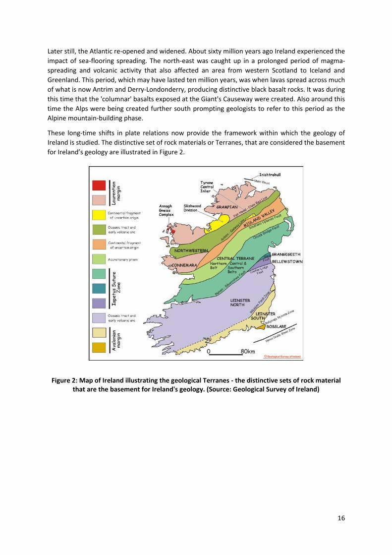
These long-time shifts in plate relations now provide the framework within which the geology of
Ireland is studied. The distinctive set of rock materials or Terranes, that are considered the basement
for Ireland’s geology are illustrated in Figure 2.
Figure 2: Map of Ireland illustrating the geological Terranes - the distinctive sets of rock material that are the basement for Ireland's geology. (Source: Geological Survey of Ireland)

17
2.2 Geology of Northern Ireland The geology of Northern Ireland has a variety of rocks unsurpassed by any other district of similar size in the British Isles and includes every geological system from the Moinian to the Quaternary, with the exception of the Cambrian, together with a wide variety of glacial and recent deposits. Before embarking upon a detailed exploration of the geology of Northern Ireland, and in order to help view the rocks in their true context, it is worth very briefly considering the main events which have shaped the region. A detailed discussion of the geological evolution of Northern Ireland and the survey area is not appropriate here as accounts can be found in the literature references and bibliography cited at the end of this report. The diversity of rocks, their composition, structure, the fossils and minerals they contain, and the processes which have shaped them have enabled geologists to decipher the history and evolution of Northern Ireland. The rocks of Northern Ireland are illustrated in Figure 3 and their history summarised in Table 1.
Figure 3: The rocks of Northern Ireland (GSNI)

18
Table 1: Geological timescale illustrating the geological history of Northern Ireland
PERIOD AGE (millions
of years)
MAIN NORTHERN IRISH ROCK
TYPES
GEOLOGICAL ENVIRONMENT
EVOLUTION OF PLANT AND ANIMAL LIFE
QUATERNARY 1.6 - 0.01
Blown sand, peat, sand, gravel and boulder clay.
Beach, lake, river and peat bogs. Glacial deposits from glaciers and ice-caps.
Modern humans.
TERTIARY 65 - 1.6 Clay, lignite, basalt lava.
Marsh and lakes. Fissure eruptions.
Earliest hominids. Widespread mammals. First primitive apes. Main bird groups present.
CRETACEOUS 135 - 65 White limestone.
Marine conditions with accumulating planktonic material.
Extinction of dinosaurs, plesiosaurs and ammonites. Early flowering plants.
JURASSIC 195 - 135
Mudstone with minor limestone.
Marine conditions. Dinosaurs dominant on land, plesiosaurs in oceans and pterosaurs in air. Early mammals.
TRIASSIC 250 - 195
Red mudstone with salt. Sandstone.
Coastal lagoons. Shallow water in continental desert.
First dinosaurs and large marine reptiles. Ammonites common.
PERMIAN 290 - 250
Limestone and sandstone.
Desert conditions with occasional marine influence.
Reptiles spread on land. Insects spread. Conifers common.
CARBONIFEROUS 355 - 290
Sandstone and minor coal. Limestone.
Coastal lagoons. Marine with coral reefs.
Amphibians spread. Shark-like fishes. Early trees and reptiles appear.
DEVONIAN 410 - 355
Sandstone, mudstone, conglomerate.
Continental desert with periodic floods.
First amphibians. Fern-like plants on land.
SILURIAN 438 - 410
Shale and sandstone.
Mainly deep marine conditions. Occasional volcanic activity.
First land plants. Armoured, jawless fishes common.
ORDOVICIAN 510 - 438
Early fishes appear. Graptolites, trilobites and brachiopods common in oceans.
CAMBRIAN 570 - 510
Not present. Dominance of trilobites in seas and development of early shelled forms.
PRECAMBRIAN 4,600 - 570
Metamorphic rocks including schist and marble.
Sedimentary and some igneous rocks changed by later metamorphism.
Early multi-celled animals. Early bacteria and algae.

19
The oldest rocks in Northern Ireland form the uplands of the Sperrin Mountains and north-east Antrim. Formed from sediments laid down in basins on the American side of the Iapetus Ocean, they show that not only did part of Ireland once form part of that continent, but also that tremendous collisions occurred, producing mountains out of materials formed on ocean floors. Other sediments which accumulated on this ancient ocean floor have been preserved as a series of sandstone and shale, forming the lowlands of Down and Armagh. During a second phase of mountain building, granitic rocks were emplaced below the Earth’s surface.
Desert conditions prevailed during the Devonian period with Northern Ireland once again present as dry land. The erosion of a now vanished mountain chain and volcanoes produced sediments which in turn led to the formation of new rocks for example, the conglomerates of Cushendun.
Returning marine conditions during the Carboniferous period resulted in the development of extensive limestone formations. Examples of these can be seen in Fermanagh where cave systems have developed. Some of the finest examples are to be found in the area of the Marble Arch Show-Caves. Progressive shallowing of the ocean occurred later in the Carboniferous until river deltas dominated the area. Great thicknesses of sand and mud were preserved with organic remains forming the coalfields of Ballycastle and Coalisland.
During the Triassic a notable climatic change occurred with arid desert conditions prevailing. Occasional flood events deposited sand in shallow lakes producing sandstones. A gradual return to shallow marine basins resulted in the formation of great thicknesses of red mudstone sandwiching massive beds of salt, evidence of which can be found in the Carrickfergus area.
During the Jurassic period the seas deepened leading to the formation of grey mudstone and limestone now found mainly around the Antrim coast. These rocks yield interesting fossils but their most visible contribution to the landscape has been in promoting instability of overlying rocks. Landslips of various types, both active and stable, can be seen on the Antrim coast road at Minnis, north of Ballygally, and at Garron Point.
Marine conditions were maintained through much of the succeeding Cretaceous period. Initially sandstones formed and were later overlain by white limestones. By the end of the Cretaceous a land mass broadly recognisable as Ireland had continued its northward movement to a position similar to southern France today. Weathering of the limestone surface created a karst landscape with sinkholes and caves. These features are visible today on top of much of the chalk.
The opening up of the north Atlantic, a process continuing today, was accompanied by widespread volcanic activity producing a basalt plateau, the eroded remains of which dominate Antrim and parts of Derry-Londonderry. Successive lava flows covered the land producing the Giant's Causeway while some molten bodies failed to reach the surface but have been exposed by subsequent erosion resulting in the formation of Fair Head and Ramore Head on the north coast. Elsewhere combinations of surface volcanic action and intruded molten magma resulted in the formation of the sites like Tardree hill in Antrim. This widespread volcanic activity was also accompanied by frequent shifts in the relative levels of the land and faulting.
The Pleistocene brought a major change in climate to Northern Ireland. Ice masses moved over the land eroding and re-depositing vast amounts of material. Ice action in many lowland areas formed drumlin belts, while many upland areas were generally smoothed. As ice melted a range of landforms developed including moraines, eskers and deltas.
20
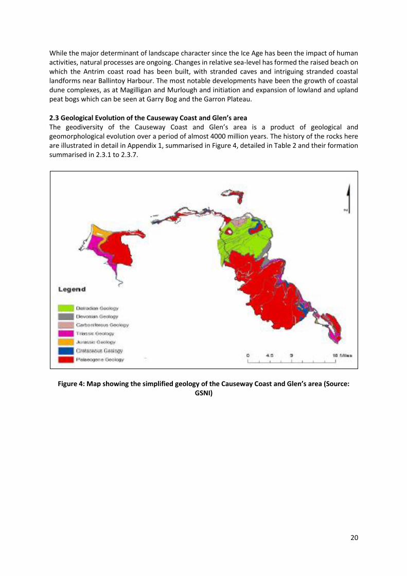
While the major determinant of landscape character since the Ice Age has been the impact of human activities, natural processes are ongoing. Changes in relative sea-level has formed the raised beach on which the Antrim coast road has been built, with stranded caves and intriguing stranded coastal landforms near Ballintoy Harbour. The most notable developments have been the growth of coastal dune complexes, as at Magilligan and Murlough and initiation and expansion of lowland and upland peat bogs which can be seen at Garry Bog and the Garron Plateau.
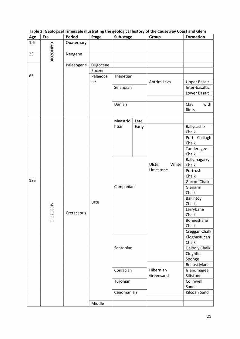
2.3 Geological Evolution of the Causeway Coast and Glen’s area The geodiversity of the Causeway Coast and Glen’s area is a product of geological and geomorphological evolution over a period of almost 4000 million years. The history of the rocks here are illustrated in detail in Appendix 1, summarised in Figure 4, detailed in Table 2 and their formation summarised in 2.3.1 to 2.3.7.
Figure 4: Map showing the simplified geology of the Causeway Coast and Glen’s area (Source:
GSNI)
21
Table 2: Geological Timescale illustrating the geological history of the Causeway Coast and Glens
Age Era Period Stage Sub-stage Group Formation
1.6 CA
INO
ZOIC
Quaternary
23
Neogene
65
Palaeogene Oligocene
Eocene
Palaeocene
Thanetian
Antrim Lava Upper Basalt
Selandian
Inter-basaltic
Lower Basalt
Danian
Clay with flints
135
MESO
ZOIC
Cretaceous
Late
Maastrichtian
Late
Early Ulster White Limestone
Ballycastle Chalk
Port Calliagh Chalk
Tanderagee Chalk
Campanian
Ballymagarry Chalk
Portrush Chalk
Garron Chalk
Glenarm Chalk
Ballintoy Chalk
Larrybane Chalk
Boheeshane Chalk
Creggan Chalk
Santonian
Cloghastucan Chalk
Galboly Chalk
Cloghfin Sponge
Hibernian Greensand
Belfast Marls
Coniacian Islandmagee Siltstone
Turonian Colinwell Sands
Cenomanian Kilcoan Sand
Middle

22
Early
205
Jurassic
Late
Middle
Early
Pliensbachian
Waterloo Mudstone Siemurian
Hettangian
250
Triassic
Late
Rhaetian
Penarth Westbury
Lilstock
Norian
Mercia Mudstone
Knocksoghey
Coolmaghra Skerry
Glenstaghey
Carnian Suitcase Sandstone
Middle Ladinian Craiganee
Anisian Lagavarra
Sherwood Sandstone
Early Olenekian
Induan
290
PALAEOZOIC
Permian
354
Carboniferous
Westphalian
Namurian
Pendleian
Ballycastle Group
Ballyvoy Sandstone
Visean
Brigantian
Murlough Shale
Glenshesk Tuff
Carey River Basalt
English Sandstone
Tournaisian
417
Devonian
Late Red Arch
Middle
Early
Cross Slieve
Cushendun
Ballyagan
Cushendall
442
Silurian
489
Ordovician

23
545
Cambrian
1000
PROTEROZOIC
Neo
Dalradian
Southern Highland
Glendun
Runabay
Altmore
4600
Meso
Argyll
Tayvallich
Torr Head Limestone
Crinan Owencam
Murlough Bay
Appin Blair Atholl
Ballachulish
24
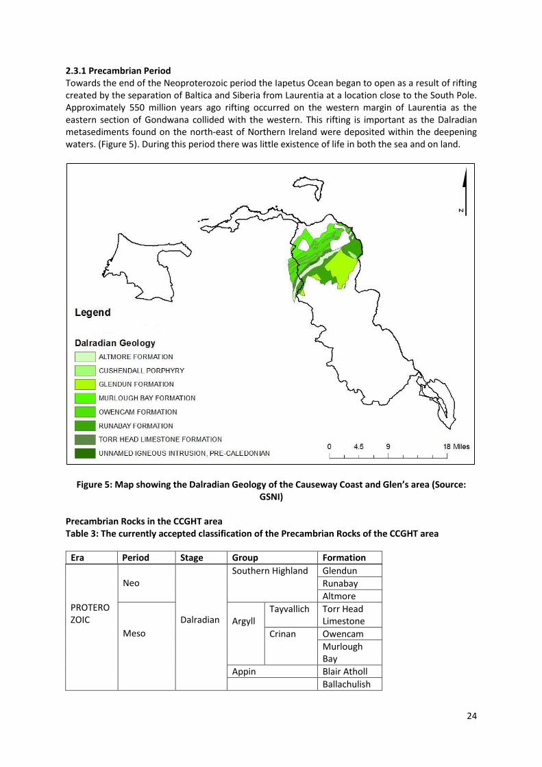
2.3.1 Precambrian Period Towards the end of the Neoproterozoic period the Iapetus Ocean began to open as a result of rifting created by the separation of Baltica and Siberia from Laurentia at a location close to the South Pole. Approximately 550 million years ago rifting occurred on the western margin of Laurentia as the eastern section of Gondwana collided with the western. This rifting is important as the Dalradian metasediments found on the north-east of Northern Ireland were deposited within the deepening waters. (Figure 5). During this period there was little existence of life in both the sea and on land.
Figure 5: Map showing the Dalradian Geology of the Causeway Coast and Glen’s area (Source: GSNI)
Precambrian Rocks in the CCGHT area Table 3: The currently accepted classification of the Precambrian Rocks of the CCGHT area
PROTEROZOIC
Neo
Dalradian
Southern Highland Glendun
Runabay
Altmore
Meso
Argyll
Tayvallich Torr Head Limestone
Crinan Owencam
Murlough Bay
Appin Blair Atholl
Ballachulish
Era Period Stage Group Formation
25
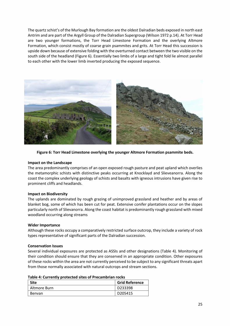
The quartz schist’s of the Murlough Bay formation are the oldest Dalradian beds exposed in north east Antrim and are part of the Argyll Group of the Dalradian Supergroup (Wilson 1972 p.14). At Torr Head are two younger formations, the Torr Head Limestone Formation and the overlying Altmore Formation, which consist mostly of coarse grain psammites and grits. At Torr Head this succession is upside down because of extensive folding with the overturned contact between the two visible on the south side of the headland (Figure 6). Essentially two limbs of a large and tight fold lie almost parallel to each other with the lower limb inverted producing the exposed sequence.
Figure 6: Torr Head Limestone overlying the younger Altmore Formation psammite beds.
Impact on the Landscape The area predominantly comprises of an open exposed rough pasture and peat upland which overlies the metamorphic schists with distinctive peaks occurring at Knocklayd and Slieveanorra. Along the coast the complex underlying geology of schists and basalts with igneous intrusions have given rise to prominent cliffs and headlands. Impact on Biodiversity The uplands are dominated by rough grazing of unimproved grassland and heather and by areas of blanket bog, some of which has been cut for peat. Extensive conifer plantations occur on the slopes particularly north of Slievanorra. Along the coast habitat is predominantly rough grassland with mixed woodland occurring along streams Wider Importance Although these rocks occupy a comparatively restricted surface outcrop, they include a variety of rock types representative of significant parts of the Dalradian succession. Conservation Issues Several individual exposures are protected as ASSIs and other designations (Table 4). Monitoring of their condition should ensure that they are conserved in an appropriate condition. Other exposures of these rocks within the area are not currently perceived to be subject to any significant threats apart from those normally associated with natural outcrops and stream sections. Table 4: Currently protected sites of Precambrian rocks
Site Grid Reference
Altmore Burn D233398
Benvan D205415

26
Carnaneigh D256365
Cushendun Bay and Rock Port D252335
Escort Port D227407
Knocknacarry Bridge, Cushendun D240327
Leckpatrick Point D225397
Loughan Bay D242383
Loughareema D206356
Torr Head D234406
Selected References A full site description for each of the above sites is available at http://www.habitas.org.uk/escr
27
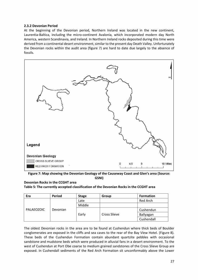
2.3.2 Devonian Period At the beginning of the Devonian period, Northern Ireland was located in the new continent, Laurentia-Baltica, including the micro-continent Avalonia, which incorporated modern day North America, western Scandinavia, and Ireland. In Northern Ireland rocks deposited during this time were derived from a continental desert environment, similar to the present day Death Valley. Unfortunately the Devonian rocks within the audit area (figure 7) are hard to date due largely to the absence of fossils.
Figure 7: Map showing the Devonian Geology of the Causeway Coast and Glen’s area (Source: GSNI)
Devonian Rocks in the CCGHT area Table 5: The currently accepted classification of the Devonian Rocks in the CCGHT area
Era Period Stage Group Formation
PALAEOZOIC
Devonian
Late Red Arch
Middle
Early
Cross Slieve
Cushendun
Ballyagan
Cushendall
The oldest Devonian rocks in the area are to be found at Cushendun where thick beds of Boulder conglomerates are exposed in the cliffs and sea caves to the rear of the Bay View Hotel. (Figure 8). These beds of the Cushendun Formation contain abundant quartzite pebbles with occasional sandstone and mudstone beds which were produced in alluvial fans in a desert environment. To the west of Cushendun at Port Obe coarse to medium grained sandstones of the Cross Slieve Group are exposed. In Cushendall sediments of the Red Arch Formation sit unconformably above the Lower
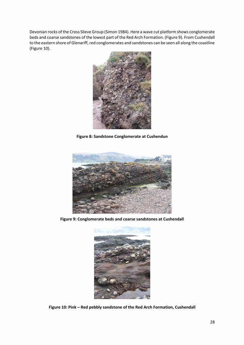
28
Devonian rocks of the Cross Slieve Group (Simon 1984). Here a wave cut platform shows conglomerate beds and coarse sandstones of the lowest part of the Red Arch Formation. (Figure 9). From Cushendall to the eastern shore of Glenariff, red conglomerates and sandstones can be seen all along the coastline (Figure 10).
Figure 8: Sandstone Conglomerate at Cushendun
Figure 9: Conglomerate beds and coarse sandstones at Cushendall
Figure 10: Pink – Red pebbly sandstone of the Red Arch Formation, Cushendall
29
Impact on the Landscape The exposures are located along the coastal fringe of the glacial valleys of Glendun, Glenann, Glenballyeamon and Glenariff. The rocks principal impact on the landscape is their vivid red colour and the coastal landforms that are found most notably the Red Arch. Impact on Biodiversity Much of the coastline is composed of a rock platform and boulders backed by maritime cliff and slopes in which both fauna and flora are generally of good diversity. The sand dunes at Waterfoot are degraded as a result of both natural processes and recreational pressures. Wider Importance Although they cannot be conclusively shown to be of Devonian age, these rocks are of importance in understanding both the geological history of Northern Ireland and the areas place in the geological evolution of Great Britain and Ireland Conservation Issues Several individual exposures are protected as ASSIs and other designations (Table 6). Monitoring of their condition should ensure that they are conserved in a condition appropriate to their importance as geological features. Table 6: Currently protected sites of Devonian rocks
Site Grid Reference
Cushendun - Bay Hotel to Cave House tunnel D252327, D25253254
Cushendun - Cave House (south of) D25373232
Cross Slieve Group; Cushendun to Port Obe D252326, D247289
Red Arch Formation; Cushendall to Red Arch, Glenariff D244276, D243261
Lifeboat House, Cushendall D244269
Port Obe, Cushendall D24702882
Red Arch and coastal exposures, Waterfoot D244262
Red Arch, Waterfoot D24352630
Selected References A full site description for each of the above sites is available at http://www.habitas.org.uk/escr

30
2.3.3 Carboniferous Period The beginning of the Carboniferous period was marked by a gradual flooding of the desert landscape by a sea that advanced from the south-east. During this time there was a series of sea level fluctuations as a result of increased plate spreading activity that occurred between the formation of Laurentia and Pangaea. The warm shallow seas provided ideal conditions for fish, shellfish and corals which eventually precipitated as calcium carbonate. The sandstones and limestone produced from this marine environment became finer as the waters rose. In Ireland as a whole limestone is the most common rock substrate but only a small amount exists in Northern Ireland due to extensive erosion (Figure 11).
Figure 11: Map showing the Carboniferous Geology of the Causeway Coast and Glen’s area (Source: GSNI)
Carboniferous Rocks in the CCGHT area Table 7: The currently accepted classification of the Carboniferous Rocks of the CCGHT area
Era Period Stage Group Formation
PALAEOZOIC
Carboniferous
Westphalian
Namurian
Ballycastle Group
Ballyvoy Sandstone
Visean
Murlough Shale
Glenshesk Tuff
Carey River Basalt
English Sandstone
Tournaisian
31
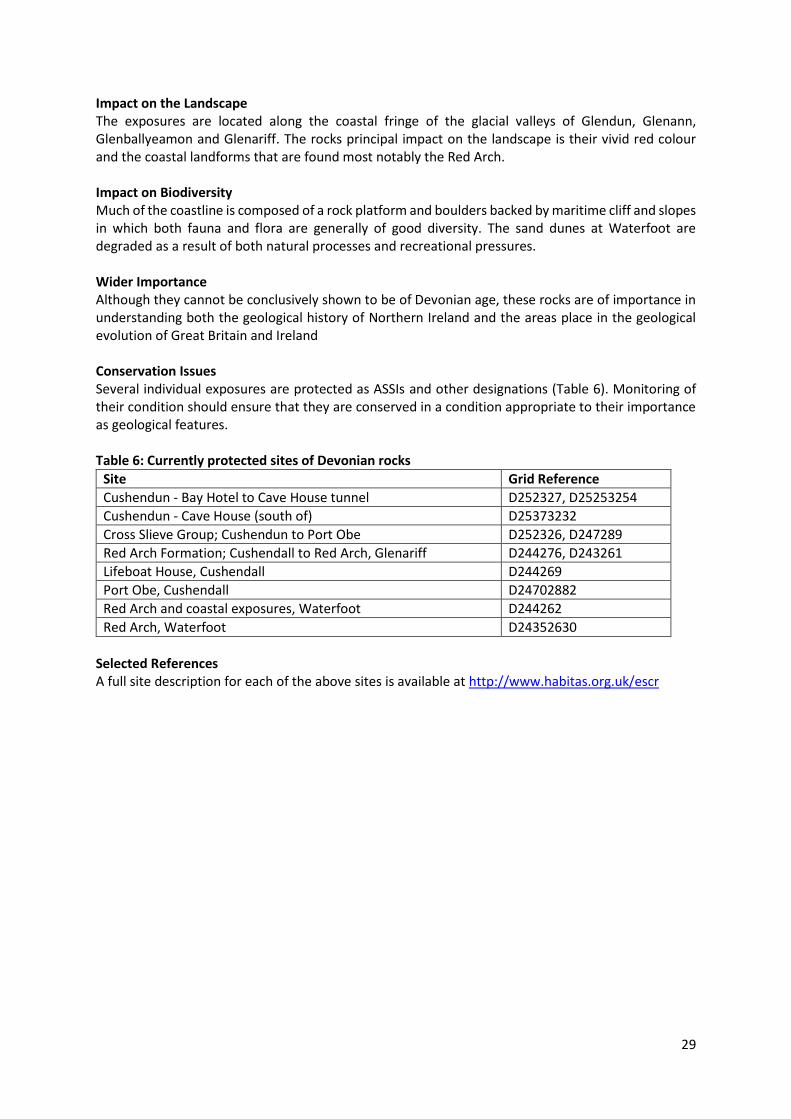
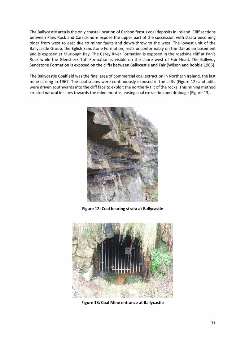
The Ballycastle area is the only coastal location of Carboniferous coal deposits in Ireland. Cliff sections between Pans Rock and Carrickmore expose the upper part of the succession with strata becoming older from west to east due to minor faults and down-throw to the west. The lowest unit of the Ballycastle Group, the Eglish Sandstone Formation, rests unconformably on the Dalradian basement and is exposed at Murlough Bay. The Carey River Formation is exposed in the roadside cliff at Pan’s Rock while the Glenshesk Tuff Formation is visible on the shore west of Fair Head. The Ballyvoy Sandstone Formation is exposed on the cliffs between Ballycastle and Fair (Wilson and Robbie 1966). The Ballycastle Coalfield was the final area of commercial coal extraction in Northern Ireland, the last mine closing in 1967. The coal seams were continuously exposed in the cliffs (Figure 12) and adits were driven southwards into the cliff face to exploit the northerly tilt of the rocks. This mining method created natural inclines towards the mine mouths, easing coal extraction and drainage (Figure 13).
Figure 12: Coal bearing strata at Ballycastle
Figure 13: Coal Mine entrance at Ballycastle

32
Impact on the Landscape The narrow coastal strip between Ballycastle and Fairhead where the Carboniferous exposures are best viewed give rise to prominent cliff vistas of striking contrasts in colour and form. Impact on Biodiversity The underlying geology and the spoil heaps along the Ballycastle coal field exposures give rise to both base rich and acidic habitats, including wet grassland, base-rich flushes and maritime heath. The mine entrances provide quality habitats for bat species. Wider Importance Although of no significant economic value, the coastal exposures between Ballycastle and Fair Head are a prime teaching area for students from Key Stage 1 - 3 to university level. Conservation Issues Most of the exposures of these rocks are robust elements of the landscape however the potential threat of ongoing development pressures especially focused around the provision of tourism infrastructure should be closely monitored. Several individual exposures are protected as ASSIs and other designations (Table 8). Monitoring of their condition should ensure that they are conserved in a condition appropriate to their importance as geological features. Table 8: Currently protected sites of Carboniferous rocks
Selected References A full site description for each of the above sites is available at http://www.habitas.org.uk/escr.
Site Gris Reference
Ballycastle Coalfield D133414, D164426
Portnaloub D167431

33
2.3.4 Triassic Period The Triassic period was indicative of dry conditions suggesting an arid desert with low-lying plains and intermittent flash floods. This resulted in the creation of sandstones, many of which have ripple marks showing directional flow of water. By the middle of the Triassic the sandstones were replaced by salt rich mudstones that lead to evaporites such as rock salt and gypsum. The main deposit of this can be seen at Carrickfergus. By the late Triassic, the sea readvanced, creating finer sediments. The Triassic rocks of the audit area (figure 14) are divided into the Sherwood Sandstone Group, the Mercia Mudstone Group and the Penarth Group.
Figure 14: Map showing the Triassic Geology of the Causeway Coast and Glen’s area (Source: GSNI) Triassic Rocks in the CCGHT area Table 9: The currently accepted classification of the Triassic Rocks of the CCGHT area
Era Period Stage Group Formation
MESOZOIC
Triassic
Late
Waterloo
Penarth Westbury
Lilstock
Mercia Mudstone
Knocksoghey
Coolmaghra Skerry
Glenstaghey
Suitcase Sandstone
Middle Craiganee
Lagavarra
Sherwood Sandstone
Early
34
Triassic rocks outcrop in the Rathlin and Larne-Lough Neagh basins, to the north and south of the Dalradian ridge which stretches from Torr Head to the Sperrin Mountains. The Rathlin Basin succession crops out principally near Dungiven and northwards to Magilligan and Lough Foyle, and is also known from the Magilligan borehole. Farther east, in north County Antrim, the succession is known mainly from the Port More borehole. Only small outcrops occur at Murlough Bay. Impact on the Landscape Triassic rocks have no significant impact on the audit area landscape Impact on Biodiversity Over much of their comparatively restricted outcrop within the survey area, Triassic rocks are substantially concealed beneath a mantle of superficial mainly Quaternary deposits. Wider Importance Good quality sections through the Triassic rocks are not common in this area. The rocks do form extensive aquifers along the Lagan Valley and potential hydrocarbon reservoirs in the Rathlin Basin. Conservation Issues Exposures of these sections are mainly in small stream sections and abandoned quarries. There are no perceived threats to the integrity of any exposures or features related to these rocks Selected References A full description of Triassic rocks within the study area is available at http://www.habitas.org.uk/escr
35
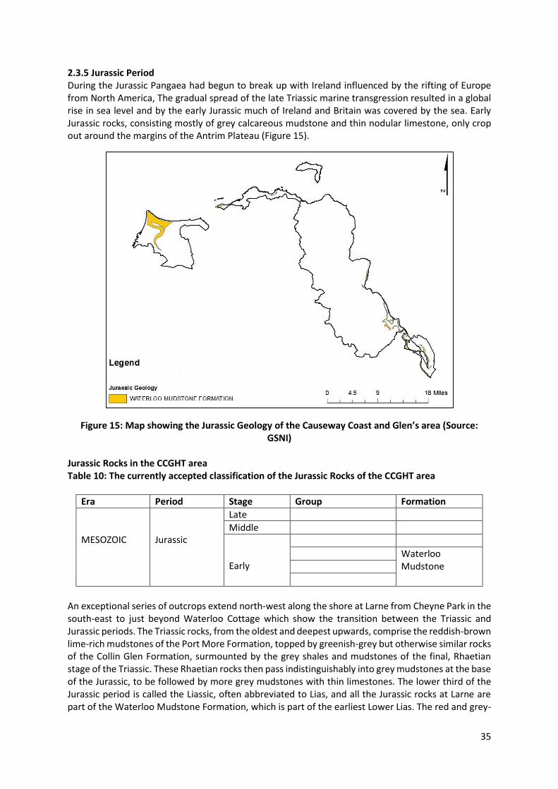
2.3.5 Jurassic Period During the Jurassic Pangaea had begun to break up with Ireland influenced by the rifting of Europe from North America, The gradual spread of the late Triassic marine transgression resulted in a global rise in sea level and by the early Jurassic much of Ireland and Britain was covered by the sea. Early Jurassic rocks, consisting mostly of grey calcareous mudstone and thin nodular limestone, only crop out around the margins of the Antrim Plateau (Figure 15).
Figure 15: Map showing the Jurassic Geology of the Causeway Coast and Glen’s area (Source: GSNI)
Jurassic Rocks in the CCGHT area Table 10: The currently accepted classification of the Jurassic Rocks of the CCGHT area
Era Period Stage Group Formation
MESOZOIC
Jurassic
Late
Middle
Early
Waterloo Mudstone
An exceptional series of outcrops extend north-west along the shore at Larne from Cheyne Park in the south-east to just beyond Waterloo Cottage which show the transition between the Triassic and Jurassic periods. The Triassic rocks, from the oldest and deepest upwards, comprise the reddish-brown lime-rich mudstones of the Port More Formation, topped by greenish-grey but otherwise similar rocks of the Collin Glen Formation, surmounted by the grey shales and mudstones of the final, Rhaetian stage of the Triassic. These Rhaetian rocks then pass indistinguishably into grey mudstones at the base of the Jurassic, to be followed by more grey mudstones with thin limestones. The lower third of the Jurassic period is called the Liassic, often abbreviated to Lias, and all the Jurassic rocks at Larne are part of the Waterloo Mudstone Formation, which is part of the earliest Lower Lias. The red and grey-

36
green mudstones of the Triassic were deposited in shallow lakes in desert lowlands (Ivimey-Cook 1975). During the Rhaetian the sea began to flood into these lowlands and at Larne beds crowded with the small marine bivalve shells Rhaetavicula contorta and Eotrapezium show the onset of marine conditions.
About 18m above these beds the earliest Jurassic fossils are found. Jurassic rocks can be subdivided into zones, as defined by the ammonites they contain, and the first four zones (planorbis, liasicus, angulata and bucklandi) and possibly the fifth (semicostatum) all occur at Larne. The Waterloo foreshore and the rocky tide-line and low cliffs behind (Figure 16) constitute the largest Jurassic outcrop in Ireland and because it is constantly refreshed by the erosive effects of the sea, it is one of the best places to collect Jurassic fossils. A rich variety of bivalves, as well as brachiopods, crinoids, gastropods, belemnites and ammonites can be found and the Ulster Museum has collections bearing the remains of ichthyosaurs and plesiosaurs.
Figure 16: The rocks at Waterloo Bay are of international importance to scientists looking at the boundary between the Triassic and Jurassic periods.
An active mudflow, at Minnis North (Figure 17) on the Antrim coast, has also been the source of well-preserved basal Jurassic ammonites. However the strata are all highly disturbed but many distinctive lithologies found in the debris here can be matched with specific beds at Waterloo Bay some 10 km to the east.
Figure 17: Mudslide at Minnis North
37
The shore sections on the east side of the Portrush promontory show an extensive area of hornfelsed Lias shales of the Waterloo Mudstone Formation overlying the massive dolerite of the Portrush Sill. These sections played a pivotal role in the development of geological science and were the debating ground between the Vulcanists who believed in a volcanic origin and the Neptunists who postulated an aqueous origin. This is discussed in greater detail in Section 3.0.
Impact on the Landscape Where rocks overlie the softer, less competent Jurassic rocks mudflows and landslips are a common occurrence. This is particularly evident at Garron and Binevenagh where rotational slips have influence the profile of the coastal cliffs. These are discussed in greater detail in Section 2.5. Impact on Biodiversity Rotational slips have helped create topographical diversity on the basalt escarpment leading to local variation in soil type and enhanced flora diversity. Slope instability resulting in mudflows has prevented longer term species colonisation. Wider Importance Though Lias and Rhaetian beds underlie most of the Cretaceous Ulster White Limestone Formation of north east Ireland, good exposures are rare because of the extensive landslips and mudslides which rim the basalts of the Antrim Plateau. The Waterloo exposure is of high importance in the context of Irish geological studies and as a western-most exposure in Europe. Conservation Issues Several individual exposures are protected as ASSIs and other designations (Table 11). Monitoring of their condition should ensure that they are conserved in a condition appropriate to their importance as geological features. Table 11: Currently protected sites of Jurassic rocks
Site Grid Reference
Minnis North Mudflow D339135
White Park Bay D008443, D029449
Portrush – Jurassic C857410
Waterloo D410034, D409038
Selected References A full description for each of the above sites is available at http://www.habitas.org.uk/escr.
Simms M.J. and Jeram J. (2007) Waterloo Bay, Larne, Northern Ireland: A potential Global Stratotype Section and Point (GSSP) for the base of the Jurassic System ISJS Newsletter 34 (1), 2007, pp.50-68

38
2.3.6 Cretaceous Period While Pangaea continued to break up, the Cenomanian marine transgression predominated on a global basis, meaning that Northern Ireland became submerged under a warm shallow sea in which white limestone or chalk was deposited (Figure 18). The Cretaceous system is divided into stages which are defined by their ammonite zones. In Northern Ireland, only Upper Cretaceous strata are known. The Cretaceous rocks are divided into the Hibernian Greensands Formation and the Ulster White Limestone Formation and are best seen towards White Park Bay and Garron Point. These limestone and chalk deposits contain Coccoliths, sea urchins and cigar shaped Belemnites fossils. The late Cretaceous period was a time of varied tectonic activity where regional uplift fractured and exposed the outcrops and allowed much of the deposits to be eroded. The Late Cretaceous depositional basin covered the Dalradian outcrop in north-east County Antrim and may also have extended over much of the eastern Sperrin Mountains. The end of the Cretaceous period and Mesozoic era was marked by the mass extinction of dinosaurs and ocean creatures due to the globally accepted hypothesis of an asteroid collision.
Figure 18: Map showing the Cretaceous Geology of the Causeway Coast and Glen’s area (Source:
GSNI)

39
Cretaceous Rocks in the CCGHT area Table 12: The currently accepted classification of the Cretaceous Rocks in the CCGHT area
Era Period Stage Group Formation
MESOZOIC
Cretaceous
Late
Ulster White Limestone
Ballycastle Chalk
Port Calliagh Chalk
Tanderagee Chalk
Ballymagarry Chalk
Portrush Chalk
Garron Chalk
Glenarm Chalk
Ballintoy Chalk
Larrybane Chalk
Boheeshane Chalk
Creggan Chalk
Cloghastucan Chalk
Galboly Chalk
Cloghfin Sponge
Hibernian Greensand
Belfast Marls
Islandmagee Siltstone
Colinwell Sands
Kilcoan Sand
Middle
Early
The main outcrop of Hibernian Greensand is in southeast County Antrim comprising the Belfast Marls, Islandmagee Siltstone, Colinwell Sands and Kilcoan Sands members. The Ulster White Limestone Formation is clearly exposed at a number of localities around the coast including Garron Point, White Park Bay, Ballintoy and Portrush. At Garron Point exposed members from the Ballintoy Chalk to the Portrush Chalk all overlain by Tertiary lavas can be viewed. The area has been subjected to extensive landslipping and many of the outcrops are on tilted blocks The White Park Bay section contains important exposures of the Waterloo Mudstone Formation together with excellent outcrop of the Hibernian Greensands Formation and Ulster White Limestone Formation including the Oweynamuck flint band, the Bendoo Pebble Bed and the Altachuile Breccia. The exposures of Mesozoic rocks at White Park Bay are typical of the Rathlin Basin. The Waterloo Mudstone Formation found here is rarely exposed in north Antrim and these outcrops have provided a diverse fauna. The lowest members of the Ulster White Limestone, the Galboly Chalk, Cloghastucan Chalk including the Oweynamuck Flint Band and the Creggan Chalk members are especially well exposed and are very accessible (Figure 19). This site is of national importance and should be conserved.
40
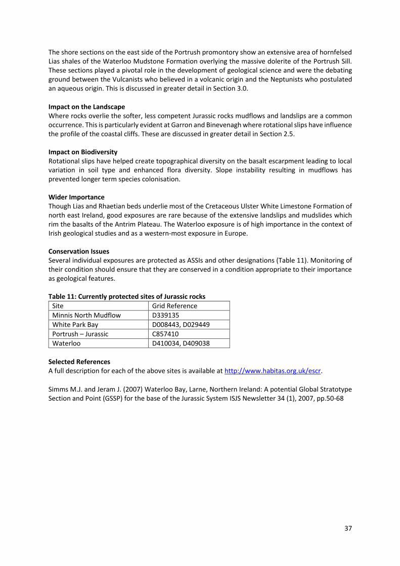
Figure 19: Tilted blocks of chalk on the west side of White Park Bay showing successive chalk members: Galboly Chalk, Cloghastucan Chalk (with Oweynamuck Flint Band clearly visible) and
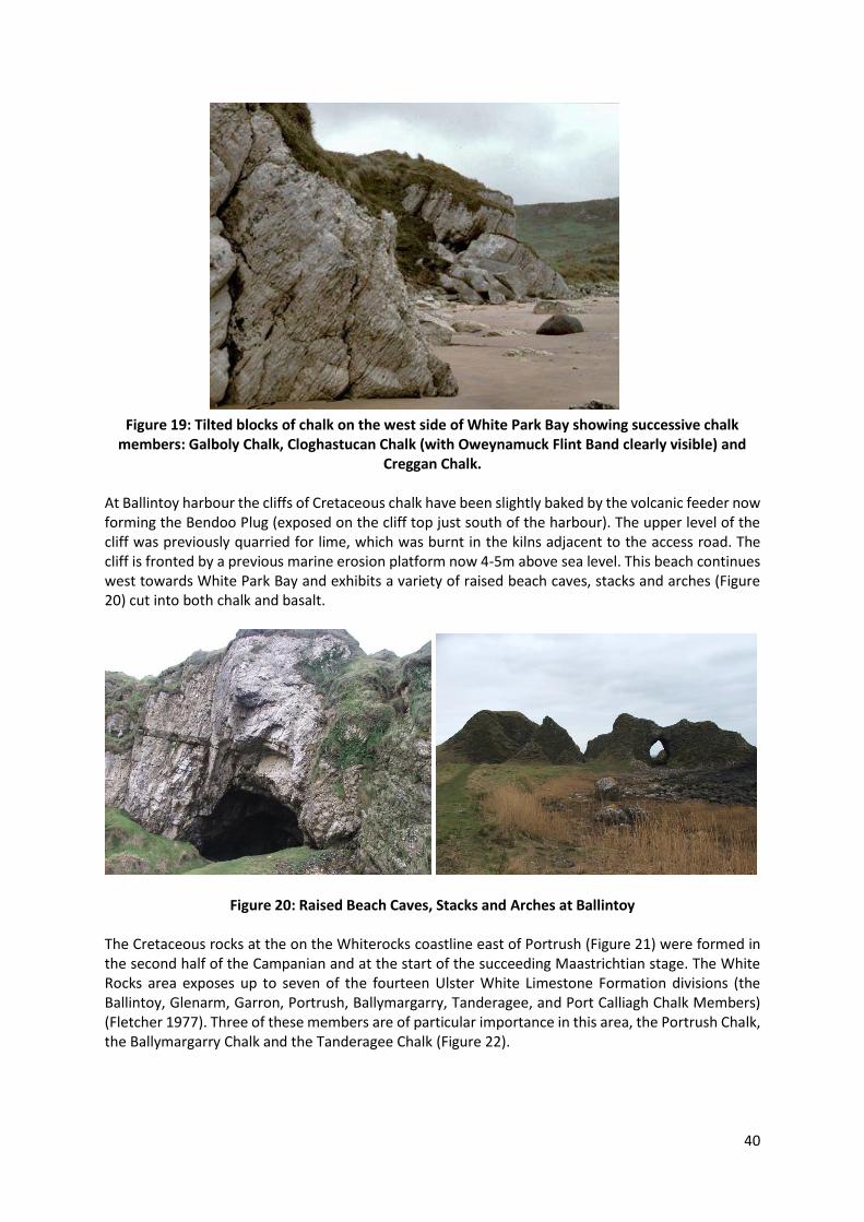
Creggan Chalk. At Ballintoy harbour the cliffs of Cretaceous chalk have been slightly baked by the volcanic feeder now forming the Bendoo Plug (exposed on the cliff top just south of the harbour). The upper level of the cliff was previously quarried for lime, which was burnt in the kilns adjacent to the access road. The cliff is fronted by a previous marine erosion platform now 4-5m above sea level. This beach continues west towards White Park Bay and exhibits a variety of raised beach caves, stacks and arches (Figure 20) cut into both chalk and basalt.
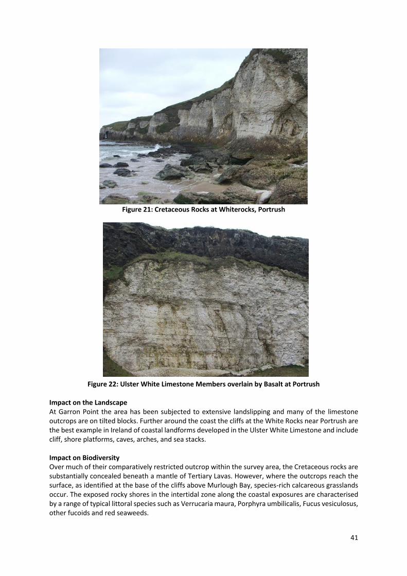
Figure 20: Raised Beach Caves, Stacks and Arches at Ballintoy The Cretaceous rocks at the on the Whiterocks coastline east of Portrush (Figure 21) were formed in the second half of the Campanian and at the start of the succeeding Maastrichtian stage. The White Rocks area exposes up to seven of the fourteen Ulster White Limestone Formation divisions (the Ballintoy, Glenarm, Garron, Portrush, Ballymargarry, Tanderagee, and Port Calliagh Chalk Members) (Fletcher 1977). Three of these members are of particular importance in this area, the Portrush Chalk, the Ballymargarry Chalk and the Tanderagee Chalk (Figure 22).
41
Figure 21: Cretaceous Rocks at Whiterocks, Portrush
Figure 22: Ulster White Limestone Members overlain by Basalt at Portrush Impact on the Landscape At Garron Point the area has been subjected to extensive landslipping and many of the limestone outcrops are on tilted blocks. Further around the coast the cliffs at the White Rocks near Portrush are the best example in Ireland of coastal landforms developed in the Ulster White Limestone and include cliff, shore platforms, caves, arches, and sea stacks. Impact on Biodiversity Over much of their comparatively restricted outcrop within the survey area, the Cretaceous rocks are substantially concealed beneath a mantle of Tertiary Lavas. However, where the outcrops reach the surface, as identified at the base of the cliffs above Murlough Bay, species-rich calcareous grasslands occur. The exposed rocky shores in the intertidal zone along the coastal exposures are characterised by a range of typical littoral species such as Verrucaria maura, Porphyra umbilicalis, Fucus vesiculosus, other fucoids and red seaweeds.
42
Wider Importance The coast between White Park Bay on the west and Ballycastle on the east comprises a suite of coastal landforms cut in Lower Cretaceous chalk and Tertiary basalt. The western section around Ballintoy is notable for its raised shoreline primarily cut in chalk. The White Rocks site provides the type section for three of the youngest Campanian and Maastrichtian members of the Ulster White Limestone Formation. From the top of the Ballintoy Chalk member exposed at Sliddery Cove to the Port Calliagh Chalk member exposed in Long Gilbert Quarry, it allows the history of chalk sedimentation in the Rathlin Basin to be determined. Also well exposed are the prominent marker bands of the Altachuile Breccia, the north Antrim Hardgrounds and the Long Gilbert Flint band. Conservation Issues Several individual exposures are protected as ASSIs and other designations (Table 13). Monitoring of their condition should ensure that they are conserved in a condition appropriate to their importance as geological features. Table 13: Currently protected sites containing Cretaceous rocks
Site Grid Reference
Capecastle Quarry D101364
Creggan Quarry D277187
Dunnaglea-Larry Bane Bay D033451, D059448
Garron Point-Cloghastucan D289253, D305234
Glenarm Quarry D304156
Murlough Bay D2142
Port Calliagh-Ballycastle D109420, D120416
White Rocks C888408, C903413
Cushenilt Burn D267244
Scawt Hill D338090
Tievebulliagh D194268
Ballintoy-Ballycastle D045445, D120413
Selected References A full description for each of the above sites is available at http://www.habitas.org.uk/escr

43
2.3.7 Palaeogene Period The beginning of the Palaeogene marked the dawn of the Cainozoic era and a marked drop in sea levels with Northern Ireland returning to a land surface. By this time Pangaea was in its final stages of breaking into the present day locations. During this rifting the Atlantic Ocean grew and Northern Ireland was subjected to extensive volcanic activity consisting of basalt lava eruptions. The eruption of the Lower Basalt and Upper Basalt formations of the Antrim Lava Group occurred in two cycles. These eruptions were in prolonged phases, forming much of the landscape observed today on the north coast (Figure 23). Between eruptions, the surface was weathered and oxidised, giving a red transitory layer called laterites. The eruptions produced features such as the Antrim Plateau and the columnar forms at the Giant’s Causeway. The region also contains numerous dykes and sills, for example, the Portrush Sill, which was formed by the movement of magma along faults and bedding planes.
Figure 23: Map showing the Palaeogene Geology of the Causeway Coast and Glen’s area (Source: GSNI) Palaeogene Rocks in the CCGHT area Table 14: The currently accepted classification of the Palaeogene Rocks in the CCGHT area
CAINOZOIC
Palaeogene
Oligocene
Eocene
Palaeocene
Antrim Lava Upper Basalt
Inter-basaltic
Lower Basalt
Clay with flints
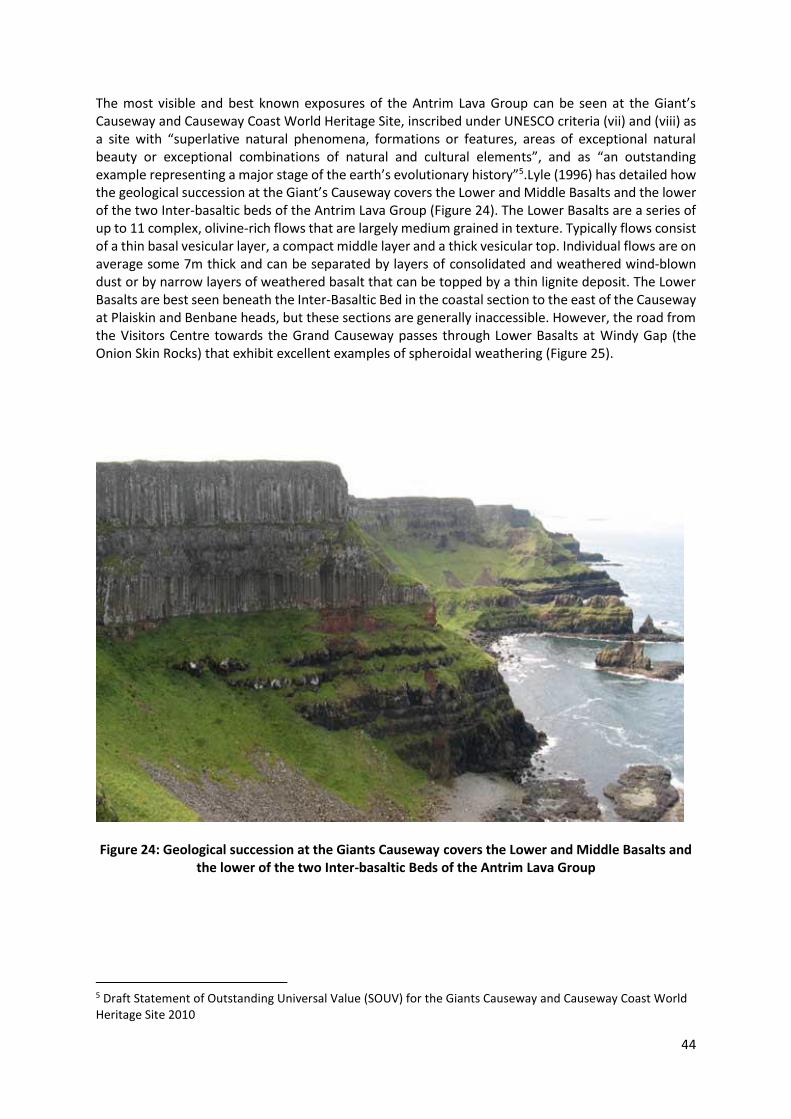
44
The most visible and best known exposures of the Antrim Lava Group can be seen at the Giant’s Causeway and Causeway Coast World Heritage Site, inscribed under UNESCO criteria (vii) and (viii) as a site with “superlative natural phenomena, formations or features, areas of exceptional natural beauty or exceptional combinations of natural and cultural elements”, and as “an outstanding example representing a major stage of the earth’s evolutionary history”5.Lyle (1996) has detailed how the geological succession at the Giant’s Causeway covers the Lower and Middle Basalts and the lower of the two Inter-basaltic beds of the Antrim Lava Group (Figure 24). The Lower Basalts are a series of up to 11 complex, olivine-rich flows that are largely medium grained in texture. Typically flows consist of a thin basal vesicular layer, a compact middle layer and a thick vesicular top. Individual flows are on average some 7m thick and can be separated by layers of consolidated and weathered wind-blown dust or by narrow layers of weathered basalt that can be topped by a thin lignite deposit. The Lower Basalts are best seen beneath the Inter-Basaltic Bed in the coastal section to the east of the Causeway at Plaiskin and Benbane heads, but these sections are generally inaccessible. However, the road from the Visitors Centre towards the Grand Causeway passes through Lower Basalts at Windy Gap (the Onion Skin Rocks) that exhibit excellent examples of spheroidal weathering (Figure 25).
Figure 24: Geological succession at the Giants Causeway covers the Lower and Middle Basalts and the lower of the two Inter-basaltic Beds of the Antrim Lava Group
5 Draft Statement of Outstanding Universal Value (SOUV) for the Giants Causeway and Causeway Coast World Heritage Site 2010
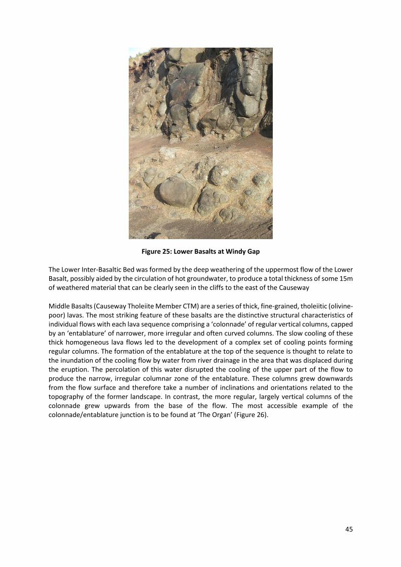
45
Figure 25: Lower Basalts at Windy Gap The Lower Inter-Basaltic Bed was formed by the deep weathering of the uppermost flow of the Lower Basalt, possibly aided by the circulation of hot groundwater, to produce a total thickness of some 15m of weathered material that can be clearly seen in the cliffs to the east of the Causeway
Middle Basalts (Causeway Tholeiite Member CTM) are a series of thick, fine-grained, tholeiitic (olivine-poor) lavas. The most striking feature of these basalts are the distinctive structural characteristics of individual flows with each lava sequence comprising a ‘colonnade’ of regular vertical columns, capped by an ‘entablature’ of narrower, more irregular and often curved columns. The slow cooling of these thick homogeneous lava flows led to the development of a complex set of cooling points forming regular columns. The formation of the entablature at the top of the sequence is thought to relate to the inundation of the cooling flow by water from river drainage in the area that was displaced during the eruption. The percolation of this water disrupted the cooling of the upper part of the flow to produce the narrow, irregular columnar zone of the entablature. These columns grew downwards from the flow surface and therefore take a number of inclinations and orientations related to the topography of the former landscape. In contrast, the more regular, largely vertical columns of the colonnade grew upwards from the base of the flow. The most accessible example of the colonnade/entablature junction is to be found at ‘The Organ’ (Figure 26).

46
Figure 26: Colonnade/entablature junction at ‘The Organ’
The Giants Causeway (Figure 27) is made up of some 40,000 vertical or gently inclined columns that are divided horizontally by ball-and-socket joints. They owe their number and regularity to the slow cooling and gradual contraction that took place at the base of a large mass of homogeneous basalt. In turn, they owe their preservation to their relative resistance to marine erosion compared to the Lower Basalts and Inter-Basaltic Bed that crop out at sea level in the two adjacent bays.
Figure 27: The Giants Causeway The Giant's Causeway is unique in Ireland in terms of the geological features displayed and the spectacular nature of the exposures. It is a major attraction for visitors, including many professional and amateur geologists, and provides much geological information in a form readily accessible to the public.

47
To the east of the Causeway, the island of Carrickarede (Figure 28) with it’s rope bridge connection to the mainland, represents a section through an explosive volcano which is unique in its extent in the whole of the Tertiary igneous province of northeast Ireland. The volcanic remains consist of exposures of agglomerate comprising fragments of basalt, chalk and lias clay ejected during the initial explosive phase of the Antrim lavas (Figure 29). This activity was caused by the gradual upward movement of magma into water-saturated sediments (Patterson 1963). Later, during a quieter period of volcanic activity, veins of dolerite were intruded into the rocks. The adjacent limestone cliffs contain one exceptional raised sea cave which has the only known example of speleotherm development within the Ulster White Limestone. Figure 28: Carrickarede volcano, now an island. This volcano erupted through the chalk during the
initial explosive stage of igneous activity in Antrim
Figure 29: Carrickarede vent agglomerate, weathered to red laterite, with basalt boulders

48
To the west of the Causeway the basalt scarp at Binevenagh represents the north-western limit of the Antrim Lava Group and is exposed from the north coast at Downhill and Castlerock, southwest to Binevenagh and then in a generally southerly direction to the hills around Benbraddagh near Dungiven. The succession at Binevenagh consists of around 100m of basalts overlying Cretaceous Chalk. The base of the succession contains a number of flows made up of thin flow units (Lyle 1985). These flows pass up into a number of prominently columnar flows separated by distinctive red boles and the upper flows in the sequence are olivine-phyric with convoluted flow banding. A feature of the base of the Binevenagh cliffs is the presence of extensive slipped masses of basalt overlying Cretaceous, Liassic and Triassic rocks (Figure 30). These are considered to be of late and post glacial age. Figure 30: Binevenagh cliffs showing the presence of extensive slipped masses of basalt overlying
Cretaceous, Liassic and Triassic rocks Impact on the Landscape The massive basalt Antrim Plateau has eroded to form a variety of upland landscapes interspersed with river valleys, bogs and deep plunging glens. The rugged outline of the plateau forms the backbone of County Antrim and north Londonderry. The dramatic cliffs of Binevenagh tower above the dune complex behind Magilligan Strand and also forms a striking landmark overlooking the Roe Basin. The eastern fringes of the plateau are marked by a bold escarpment which forms a series of striking headlands with precipitous cliffs along the coastal road. The headlands shelter a sequence of small sandy bays which are the entrances to the deep U shaped ‘Glens of Antrim’. Between the glens the undulating surface of the high plateau is comprised of blanket bog, humped-backed ridges and isolated peaks. The landform of the plateau becomes progressively shallower to the west where sweeping slopes allow the volcanic plug of Slemish Mountain to stand out as a landmark. The northern fringes of the plateau contain a sequence of spectacular coastal features such as rocky sea cliffs, wide
sweeping beaches and the Giant’s Causeway. Impact on Biodiversity The Basalt upland landscape contains valuable peatland habitats for example Garron Plateau ASSI, SAC and Ramsar site which is the most extensive area of intact upland blanket bog in Northern Ireland. The cliffs and cliff tops of the WHS include patches of heath, flushes, slips and screes, rock exposure with lichen cover and ledge/crevice flora. The basalts of Binevenagh support features of biodiversity
49
importance including arctic-alpine communities and cliff-face woodlands as well as extensive intact upland raised bog at Altikeeragh ASSI. The mosaic of habitats found upon the basalts are a result of the complex soils which have developed there. The uplands are dominated by blanket peat while the Glens to the north support a mix of freely drained brown earths on slopes with Gleys on valley bottoms. These soils reflect the diversity in habitat and species found there. Wider Importance The Giant's Causeway area and its associated basalts is one of the few geological sites in Ireland which has a national and international reputation and this imparts an importance far beyond any other single locality or section. This status has been recognised by its designation as a World Heritage Site by UNESCO. The locality was important in the advancement of the concepts of volcanology in the late 18th and early 19th centuries. Conservation Issues Several individual exposures are protected as ASSIs and other designations (Table 15). Monitoring of their condition should ensure that they are conserved in a condition appropriate to their importance as geological features. Table 15: Currently protected sites containing Palaeogene rocks
Site Grid Reference
Carrickarade D062450
Craigahulliar Quarry C883389
Fairhead D180438
Giant's Causeway C947448
Little Deer Park Quarries, Glenarm X33294149
Rathlin Island D150510
Skeagh and Craigcluggan D302062, D294081
Slemish Mountain D22150540
Tardree Mountain X31923941
Tievebulliagh D31944268
Binevenagh C690310
Selected References A full description for each of the above sites is available at http://www.habitas.org.uk/escr Lyle, P. (1996). A Geological Excursion Guide to the Causeway Coast. Environment and Heritage Service (Department of the Environment NI). Belfast: HMSO, 90p Wilson, H.E. and Manning, P.I. (1978) The Geology of the Causeway Coast. Geological Survey of Northern Ireland, published by HMSO, 2 volumes.
50
2.3.8 Quaternary Period The beginning of the Quaternary completes the geological history of the audit area. Quaternary deposits are sediments that were deposited between 2.5 million years ago and the present day. The Quaternary is divided into two periods: the Pleistocene Period dates from 2.5 million years ago till 11,500 years ago and the Holocene continues to the present day. The Quaternary saw a series of fluctuations from glacial to temperate climates finishing with the last glacial maximum approximately 13,000 years ago. This last glacial period is thought to have come during the late Midlandian with re-advancement of ice from Scotland where it created the Armoy Moraine. The effects of the earlier Munsterian and later Midlandian ice during the Pleistocene are the reason for much of the scenery and shape of today’s landscape. While the major determinant of landscape character since the Ice Age has been the impact of human activities, natural processes are also ongoing. Changes in relative sea-level has been responsible for forming the raised beach on which the Antrim coast road has been built, glacio emergent sequences at Portballintrae, stranded caves and coastal landforms near Ballintoy Harbour and slope failures on steep cliffs along the coastal fringe. The most notable recent developments have been the growth of coastal dune complexes, as at Magilligan and initiation and expansion of lowland and upland peat bogs which can be seen at Garry Bog and Garron Plateau. Examples of Quaternary and Holocene deposits in the CCGHT area Quaternary deposits within the audit area are widespread and conceal the bedrock in many of the valleys and over substantial areas of upland. In the North of Ireland, as in much of Great Britain, the surviving deposits date mainly from the Midlandian glaciation, with only very limited and uncertain evidence of earlier glacial and interglacial stages. Glacial Deposits The Armoy Moraine is a dominant feature of the local landscape and marks the southern extent of a late advance of Scottish ice which pushed sediments that had previously been deposited by an ice mass centred on Lough Neagh (Stephens et al 1975). The Armoy Moraine is up to 4km wide, extends about 20km, north-eastwards from Ballymoney into the Tow River valley and consists of large continuous ridges. Sediments within the Moraine are typical of lake deposits, probably laid down by meltwater emanating from an ice body centred on Lough Neagh. Exposures have shown that these deposits were then pushed from the northwest by an ice body of Scottish provenance. Exposures have also shown that the top of the feature has been sheared off. Together with the distribution of streamlined landforms, this indicates that the retreat of Scottish ice was followed by a northward advance of Lough Neagh-based ice. The Moraine is of great importance in reconstructing the chronology of ice front oscillations towards the end of the deglacial cycle and understanding the complexity of deglacial processes. Limited aggregate extraction perhaps reflects the fact that many of the sediments within the Moraine are of fine-grained sands and silts of lakebed origin. The pristine condition of the landform suggests that at least this part of the Moraine should be protected with regard to controls on aggregate extraction. Isostatic Adjustment The glacio emergent sequence at Portballintrae demonstrates a transition from glacigenic diamict into shallow water, wave-influenced marine sands which are overlain by late glacial shoreline gravels (McCabe et al 1994) (Figure 31). Facies evidence of this type have a low preservation potential due to erosion during isostatic uplift. It demonstrates that the environmental signature of the deglacial to late glacial transition was one of rapid local environmental changes driven by rapid rates of isostatic rebound, differential tectonics and eustatic changes. The marine sands contain a wide range of wave-influenced sedimentary structures which have not previously been described from glacigenic sequences in the UK. The facies sequence, especially the presence of wave-influenced, shallow marine

51
sands between diamict and overlying marine gravels, is the most important geological feature of the site. It demonstrates that shallow marine deposition occurred following ice retreat during a phase of high relative sea level. Within the context of the north western sector of the last British ice sheet it is the only site known to show progression from glaciomarine, to shallow marine and wave-influenced facies and eventually shoreface gravels. Figure 31: Glacio emergent sequence at Portballintrae consisting of glaciomarine diamict, shallow
marine sands and muds overlain by shoreface gravels. It demonstrates high relative sea level during ice retreat along the north coast of Ireland.
Dune Formation Magilligan, (Figure 32) with an area of 32 Km2, is the largest accumulation of coastal sands and other associated deposits in Ireland. In the last quarter of the 20th Century over 50 scientific papers describing aspects of the area have been published making it the most intensively studied of all Irish coastal deposits of the Holocene. The triangular expanse of Magilligan is made up of over 150 beach ridges (and possibly many more) with subsidiary aeolian deposits and inter-ridge peats and marls. The site in general is an important element in the sea-level history of Ireland, while it’s distal extremity, Magilligan Point, is an especially important geomorphological site as it demonstrates the relatively unusual phenomenon of prograding dunes. This contrasts with the pervasive retreat found generally in British and Irish dune systems.
Figure 32: Magilligan Dune System

52
Peatland Formation Slieveanorra and Croaghan ASSI (Figure 33) is a largely intact blanket bog characterised by undulating topography and a peatland complex consisting of a series of raised bog peat units on deeper peat within an enveloping mantle of blanket bog. It extends from Slieveanorra Mountain north over Black Hill to Croaghan Mountain. Slieveanorra itself is underlain by Palaeogene age basalts from the Antrim Lava Group. Moving northwest, the geology is composed of Dalradian rocks, predominantly metamorphosed mudstones and sandstones of the Southern Highland Group. Slieveanorra and Croaghan ASSI incorporates Slieveanorra National Nature Reserve which is comprised of both an area on the summit of Slieveanorra Mountain, which shows the different stages in the formation and erosion and regeneration of peat, and an area of deep peat to the north. This area is of special scientific interest because of its peatland flora and associated fauna.
Figure 33: Slieveanorra and Croaghan Blanket Bog Impact on the Landscape Processes which were active during the Quaternary period have exerted an important influence on the landscape. The most important of these processes undoubtedly date from the major glacial episodes, though it is important to appreciate that, in common with all landscapes, the Causeway Coast and Glens remains dynamic and is still evolving. This is discussed in greater detail in Section 2.5 Impact on Biodiversity Where Quaternary deposits mantle the solid rock the soils reflect the composition of the drift rather than the bedrock. These deposits also influence infiltration of water and the movement of groundwater. Sand and gravel deposits commonly support very well-drained soils in contrast to the poorly drained soils commonly found on spreads of till. Extensive spreads of comparatively impervious till may have encouraged the development of blanket peat. The Binevenagh and Garron plateau hosts a major proportion of Ireland’s total area of intact blanket bog. Wider Importance The Quaternary deposits of the area provide important insights into the varied Earth processes that shaped the area during episodes of glacial, interglacial and post-glacial conditions. The importance of some of the area’s Quaternary deposits in contributing to understanding of comparable deposits elsewhere in Great Britain, Ireland and beyond is recognised in the designation of a number of ESCR sites.

53
Conservation Issues Several individual exposures are protected as ASSIs and other designations (Table 16). Monitoring of their condition should ensure that they are conserved in a condition appropriate to their importance as geological features. Because most of the Quaternary deposits within the area comprise unconsolidated, or comparatively easily eroded, materials permanent exposures are uncommon. Sections through these materials, in stream banks or in quarry faces typically degrade rapidly or soon become vegetated and obscured. Permanent exposures are few and generally difficult or impossible to maintain. One of the most widespread, and internationally most significant areas of the Quaternary deposits is the extensive covering of upland peat that mantles the Antrim and Binevenagh plateau. This very recent geological deposit has much to contribute to the understanding of past and present environments which may offer valuable insights into future environmental management. In addition, the blanket bogs of the area comprise a major proportion of the European resource of this habitat. Table 16: Currently protected sites containing Quaternary and Holocene Deposits
Item Grid Reference
Armoy X295429, X29782317, X30674328, X31084391
Ballycastle Beach D121415, D134415
Church Bay, Rathlin Island D148506
Glenshesk Valley D31434343
Loughaveema D207360
Muck Island Tombolo, Island Magee D465025
Portballintrae C923423
Runkerry Strand, Bushfoot C935427
Cliff/Shore Platform Complex between Portstewart and Portrush
C815389, C85003995
Grangemore and Castlerock Sand Dunes C805355, C780361
Magilligan Complex C665387
Carey Valley D30074361, D31274408
Portstewart Strand Sand Dunes C805365
Selected References A full description for each of the above sites is available at http://www.habitas.org.uk/escr

54
2.4 Intrusive Igneous Rocks Intrusive igneous rocks are those which have formed through intrusion (emplaced) as molten rock, or magma, into the surrounding rocks. They are distinguished from volcanic, or extrusive igneous, rocks by having crystallised and cooled at depth within the Earth’s crust. Such intrusions may take a number of forms, including horizontal sheets known as sills, vertical sheets known as dykes and large, irregular bodies known as batholiths. Intrusive igneous rocks which are exposed at the surface due to erosion give vital information on a great variety of geological processes which have operated deep within the Earth’s crust. A variety of analytical techniques can be used to date the crystallisation of certain minerals within these rocks. These dates, when interpreted along with other geological evidence, provide a valuable means of assigning accurate dates to key events in Earth history. 2.4.1 Plugs The Antrim Lava Group is cut by dolerite plugs that form prominent landmarks rising above the surface of the Antrim Plateau. At least thirty of these intrusions are recognised and vary in diameter from 50m to 1km. The plugs consist mainly of olivine dolerite with local variations due to compositional zoning. This is particularly evident at Slemish Mountain that intrudes the Upper Basalt Formation (Figure 34). Slemish is the largest volcanic vent in Ireland and consists of at least three separate magma pulses. It forced its way through earlier basalts which were slightly altered in the process by the intense heat. Dykes (cross-cutting intrusions) radiate from the conduit and were originally filled with molten rock in the volcano’s active phase. There is evidence of at least three periods of activity (Patterson 1957). Two early dolerites fill the outer part of the plug and, although they cannot be separated by direct observation, they are easily differentiated by their chemistry, the later dolerite being richer in the mineral olivine. A third intrusion broke through the earlier two and spread to fill the conduit above and has a flat contact with them. Rafts of a finer-grained dolerite (thought to be fragments of solidified crust in the crater) settled through the molten lava on to the contact with the first two. These rafts (called xenoliths) and the layered nature of the earlier activity suggest that the rocks we now see on Slemish were not far below the surface of the Tertiary volcanic landscape. Slemish is a fine example of a volcanic plug that preserves evidence of late-stage processes within the vent, just before the volcano became extinct.
Figure 34: Slemish Mountain Tievebulliagh (Figure 35) near Cushendall is an inclined oval shaped dolerite plug notable for the presence of a slumped block of laterised Basalt of the Interbasaltic Formation. This has been metamorphosed to form Porcellanite, extremely resistant Hornfels that was used by Neolithic people to manufacture axe heads. Populations of Neolithic people established an axe factory here

55
somewhere around 3,000 years ago. Axes from Tievebulliagh, or the only other similar site on Rathlin Island, have been found in Britain from the north of Scotland and the Outer Hebrides to Dorset and Kent on the south coast of England.
Figure 35: Tievebulliagh Mountain At Scawt Hill the volcano has long since eroded away and the hill now exposes its roots. On its way to the surface the molten basaltic rock passed through the Cretaceous Ulster White Limestone and the reaction between the molten rock and the limestone created an extraordinary variety of minerals. The reaction had three main components: 1, the effect of heat alone on the limestone; 2, the penetration of high temperature solutions of complex chemistry from the melt into the limestone; and 3, the assimilation of limestone forming the wall of the volcanic feeder into the molten rock of the margin. The mineral assemblages at Scawt Hill demonstrate actual chemical and mineralogical relationships that had previously been anticipated in theory alone. Scawt Hill has yielded five minerals entirely new to science (larnite, scawtite, rankinite, portlandite and hydrocalumite) and elucidated the relationships between a whole range of rare minerals of similar chemistry. In all 28 minerals are known from this site (Tilley 1929, Tilley and Harwood 1931, Tilley and Alderman 1933).
Figure 36 Scwat Hill Limestone – Dolerite contact zone
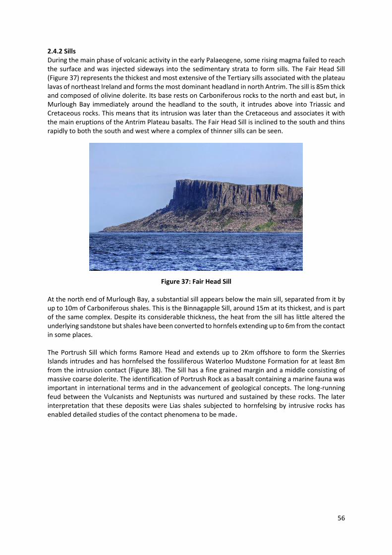
56
2.4.2 Sills During the main phase of volcanic activity in the early Palaeogene, some rising magma failed to reach the surface and was injected sideways into the sedimentary strata to form sills. The Fair Head Sill (Figure 37) represents the thickest and most extensive of the Tertiary sills associated with the plateau lavas of northeast Ireland and forms the most dominant headland in north Antrim. The sill is 85m thick and composed of olivine dolerite. Its base rests on Carboniferous rocks to the north and east but, in Murlough Bay immediately around the headland to the south, it intrudes above into Triassic and Cretaceous rocks. This means that its intrusion was later than the Cretaceous and associates it with the main eruptions of the Antrim Plateau basalts. The Fair Head Sill is inclined to the south and thins rapidly to both the south and west where a complex of thinner sills can be seen.
Figure 37: Fair Head Sill
At the north end of Murlough Bay, a substantial sill appears below the main sill, separated from it by up to 10m of Carboniferous shales. This is the Binnagapple Sill, around 15m at its thickest, and is part of the same complex. Despite its considerable thickness, the heat from the sill has little altered the underlying sandstone but shales have been converted to hornfels extending up to 6m from the contact in some places. The Portrush Sill which forms Ramore Head and extends up to 2Km offshore to form the Skerries Islands intrudes and has hornfelsed the fossiliferous Waterloo Mudstone Formation for at least 8m from the intrusion contact (Figure 38). The Sill has a fine grained margin and a middle consisting of massive coarse dolerite. The identification of Portrush Rock as a basalt containing a marine fauna was important in international terms and in the advancement of geological concepts. The long-running feud between the Vulcanists and Neptunists was nurtured and sustained by these rocks. The later interpretation that these deposits were Lias shales subjected to hornfelsing by intrusive rocks has enabled detailed studies of the contact phenomena to be made.

57
Figure: 38: Layered hornfels (baked mudstone) on top of Portrush sill.

58
2.5 Landforms Landforms make up the landscape we see today. Geomorphology is the scientific study of landforms, landscapes and processes. Landforms provide clear evidence of the processes of erosion and deposition which have shaped the land over geological time. Most landforms are the result of processes which operated within the Quaternary period. Interpretation of landforms and Quaternary sediments can thus provide evidence of environmental conditions and climatic oscillations in the recent geological past. This includes evidence for the spread of ice sheets in Ireland and Britain. Such information may provide valuable insights into likely future changes as part of studies of global warming A variety of landforms may be recognised within the audit area and can be divided into categories based on the processes that formed them, in this case, predominantly glacial and coastal, and the impacts these have had on slope morphology and stability. 2.5.1 Glacial Landforms The geographical locations of the glacial features observed today have been determined principally by a complex interaction of glacial retreat patterns, sediment availability and substrate topography. The location of the ice masses in turn was dictated by a combination of factors. Firstly, the macro-scale topography of Northern Ireland's predominately Pre-Cambrian and Tertiary landscape i.e. the Sperrin and Antrim uplands respectively, dictated the regional pattern of decay. Secondly, the meso-scale dynamics of the wasting ice masses and their interactions with local topography, and thirdly the rapidly changing climatic regimes during the deglacial period resulted in rapid geomorphic change. The dynamics of glacial erosion, the range of substrates over which the ice passed and variability in sedimentological processes which operated in ice-marginal and subglacial environments have resulted in a diverse suite of glaciofluvial deposits in the survey area. Additional factors determining the spatial location of the deposits include the interactions with other ice masses, especially those of Scottish provenance. Glaciated valleys are those whose form has been significantly modified by the erosive power of moving ice. These effects include the truncation of spurs and the creation of a characteristic ‘u-shaped’ profiles. The Glens of Antrim, especially Glenariff (Figure 39), provides a good example of a glaciated ‘U-shaped’ valley.
Figure 39: U shaped valley of Glenariff

59
Outwash plains are a common depositional feature in the lowland or valley deglacial landscapes in the Antrim Glens for example, the Glenshesk valley outwash. Glacial drainage channels, also known as meltwater channels, are channels of variable scale, usually steep-sided and flat-floored cut by large volumes of water during the melting of ice sheets and glaciers. They are commonly unrelated to the present drainage pattern. Many are today dry and devoid of any stream although some may carry disproportionately small, misfit streams. Within the area a good example can be seen at Loughaveema. Here steep-sided valley has been interpreted as a glacial meltwater channel, at a point where its course changes direction from north north-west to north-west. In this case the channels in the ice-filled Glendun to the south suddenly and catastrophically spilled over the watershed towards the Carey River system to the north diving beneath the ice cover and rapidly cutting the narrow steep-sided channel. Huge quantities of glacial sands and gravels were carried by the surge and deposited as deltas in a ponded lake in the Carey Valley (McCabe and Eyles 1988) (Figure 40).
Figure 40: Carey Valley Delta Glacial striae, or striations, are grooves or scratches formed on bed-rock surfaces caused by the scouring effect of stones or boulders in the base of a moving ice sheet or glacier. Such striations are commonly exposed beneath sheets of boulder clay or till. Fine examples were formerly exposed at Portballintrae at the beach entrance. Drumlins are ovoid mounds of glacial debris, mainly till, which were deposited beneath an ice sheet and smoothed into a streamlined shape by the passage of the over-riding ice. The term drumlin is derived from ‘druim’, a Gaelic term for a mound or rounded hill. Typical drumlins exhibit an extremely distinctive ‘half egg’ shape and commonly occur in large groups. Within the region fine examples of drumlins occur north of Dervock and Mossside orientated in a north – south direction parallel with the River Bush. Moraine is a term which was originally used to define the ridges of rock debris found adjacent to Alpine glaciers. This definition has since been expanded to include the rock debris deposit as well as the landform and is described as morainic drift. Several types of moraine, which reflect both the form and the process by which they formed, may be recognised. When the ice lobe which deposited the Armoy Moraine (Figure 41) wasted, good examples of deglacial topography were formed

60
along the lower Bann valley around Castleroe. (Charlesworth 1939, Stephens et al 1975, McCabe et 1998) Figure 41: Distribution of selected glacial geologic features and the position of the Armoy moraine
(after Charlesworth 1939; Stephens et al. 1975; McCabe et al. 1998), 2.5.2 Coastal Landforms Coastal landforms have evolved in response to local geology, sea level change and the processes of weathering. The entire coast from Magilligan to Larne displays some of the best structures in Europe. The White Rocks, extending eastward from Curran Strand to Dunluce on the Portrush-Portballintrae coast are a stretch of Cretaceous Chalk cliffs which demonstrate classic coastal landforms including chalk - cliff, shore platform, cave, arch, and sea stack (Figure 42). The chalk landforms are best developed in two locations at either end of the site. At the western (Curran Strand) end, flanking the Slidderycove Point promontory, there are a number of deep rectilinear caves and an impressive arch. Here also a number of sea stacks sticking up from the sand. Some of these are composed of chalk which has been shattered and recemented. Large blocks of basalt are sometimes embedded in this material. At the eastern (Dunluce) end of the site is Gulls Point arch with a basalt cap. Associated with this arch are a number of caves, smaller incipient arches, and sea stacks.
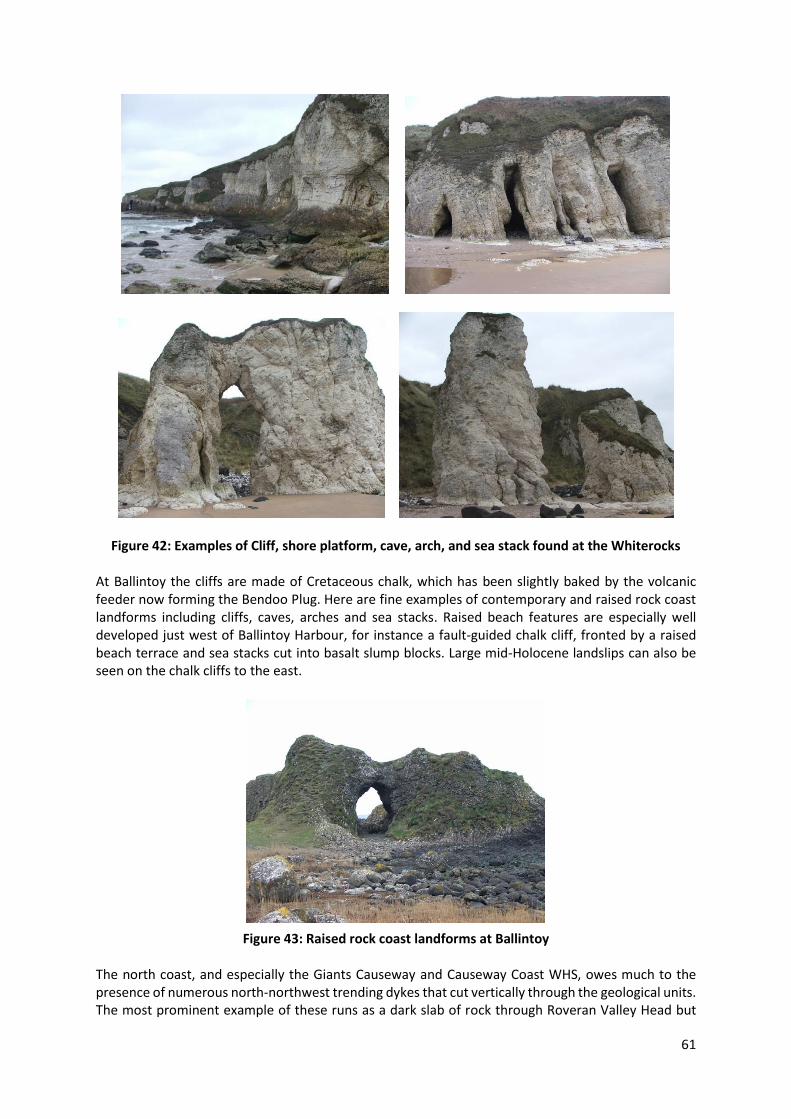
61
Figure 42: Examples of Cliff, shore platform, cave, arch, and sea stack found at the Whiterocks At Ballintoy the cliffs are made of Cretaceous chalk, which has been slightly baked by the volcanic feeder now forming the Bendoo Plug. Here are fine examples of contemporary and raised rock coast landforms including cliffs, caves, arches and sea stacks. Raised beach features are especially well developed just west of Ballintoy Harbour, for instance a fault-guided chalk cliff, fronted by a raised beach terrace and sea stacks cut into basalt slump blocks. Large mid-Holocene landslips can also be seen on the chalk cliffs to the east.
Figure 43: Raised rock coast landforms at Ballintoy The north coast, and especially the Giants Causeway and Causeway Coast WHS, owes much to the presence of numerous north-northwest trending dykes that cut vertically through the geological units. The most prominent example of these runs as a dark slab of rock through Roveran Valley Head but

62
others include the Camel Dyke in Portnaboe, two dykes that separate and define the three causeways and numerous others that can be seen running across the foreshore in areas such as Port Noffer. The variable resistance to erosion along the coastline imparted by these dykes has contributed significantly to the formation of the bays, headlands and marine erosion features that characterise the area. 2.5.3 Slopes Landslips and associated ground instability are common features around the edge of the basalt plateau in counties Antrim and Londonderry where they contribute in part to the landscape character (Figure 44). Three principal categories of slope instability can be recognised here including rotational landslips, mudflows and debris flows and rock falls.
Figure 44: Principal Areas of Landslides around the Basalt Plateau (after Johnston 2006) At a number of locations the edge of the Antrim Basalt Plateau consists of large scale, deep-seated, multiple rotational landslip features. The mechanisms behind this instability are directly related to the geological succession and the geomorphological processes that subsequently sculpted the landscape. The plateau edge is capped by basalt lavas and chalk which overlie softer, less competent, impermeable mudstone. During the last ice age ice sheets flowed along the edge of the plateau eroding the soft mudstone rocks at it’s base. This undercut and oversteepened slope became unstable and failures took place on the vertical and steeply inclined surfaces within the chalk and basalt and
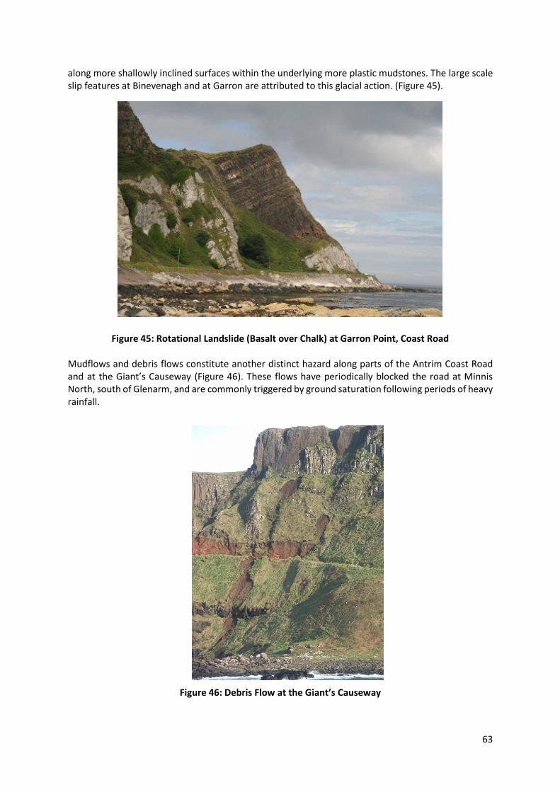
63
along more shallowly inclined surfaces within the underlying more plastic mudstones. The large scale slip features at Binevenagh and at Garron are attributed to this glacial action. (Figure 45).
Figure 45: Rotational Landslide (Basalt over Chalk) at Garron Point, Coast Road Mudflows and debris flows constitute another distinct hazard along parts of the Antrim Coast Road and at the Giant’s Causeway (Figure 46). These flows have periodically blocked the road at Minnis North, south of Glenarm, and are commonly triggered by ground saturation following periods of heavy rainfall.
Figure 46: Debris Flow at the Giant’s Causeway
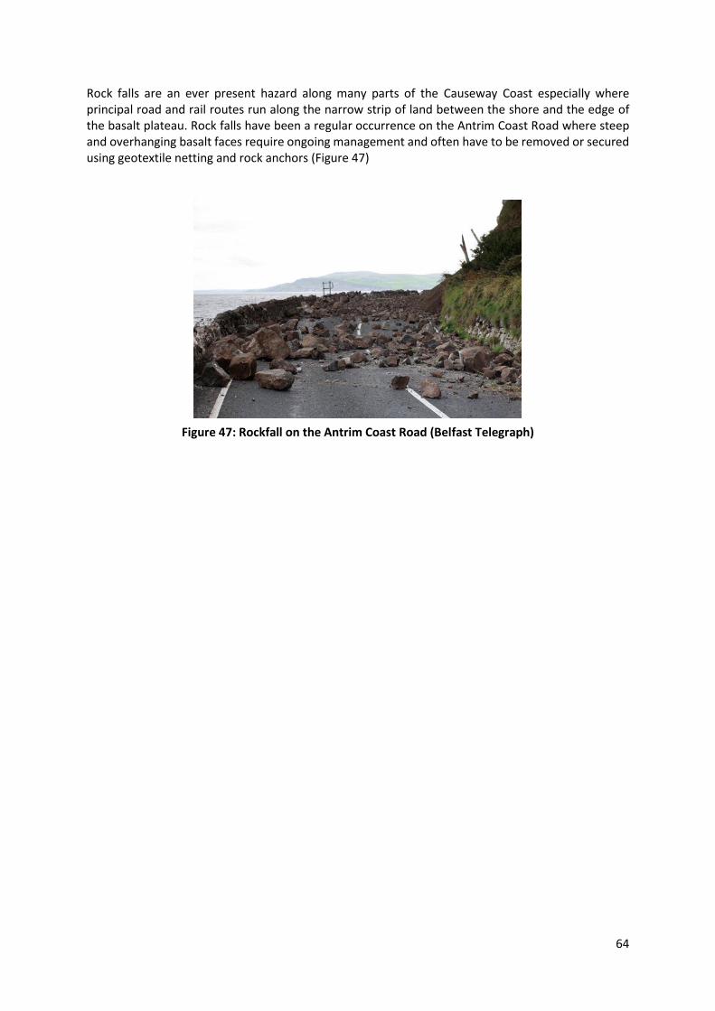
64
Rock falls are an ever present hazard along many parts of the Causeway Coast especially where principal road and rail routes run along the narrow strip of land between the shore and the edge of the basalt plateau. Rock falls have been a regular occurrence on the Antrim Coast Road where steep and overhanging basalt faces require ongoing management and often have to be removed or secured using geotextile netting and rock anchors (Figure 47)
Figure 47: Rockfall on the Antrim Coast Road (Belfast Telegraph)

65
2.6 Soils Geodiversity is a key factor influencing the formation of soils. The soils within the audit area have formed over many millennia following the end of the last glaciation, through the weathering of rocks and minerals and the accumulation of organic materials. The combination of geology, climate and topography has given rise to a wide range of soil types and properties (Cruickshank 1997). Betts (1997) notes that because of the strongly maritime climate with cool temperatures and rocks which are generally resistant to weathering and deficient in base cations, north east Antrim soils are in general more organic, more leached and wetter than those of most other European countries. The soils of the Causeway Coast and Glens area can be broadly divided into five main groups: Peats, Gleys, Podsols, Brown Earths and Rankers. None of these have developed in isolation and there are a many variations in type. Soils over most of the area are heavy, poorly drained Gleys derived from glacial clays with pockets of lighter soils associated with glacial sands and gravels. Brown Earths and Alluvial soils occur along the main river valleys. Calcareous Brown Earths are found on limestone outcrops along the escarpment and coast. On the Binevenagh and Antrim plateaux, the combination of elevation, poor drainage and severe climate has led to the development of extensive blanket bog of deep Peats that give way on the drier slopes to thinner Peats, Humic Gleys and Podsols. A summary of the soil types found is detailed below. a. Area around North East Antrim (Soil Map 5) Apart from Rathlin Island, where the soils are mainly shallow Humic and Brown Rankers on Basalt and Brown Rankers on Chalk, the soils of north east Antrim can be divided into seven main regional groupings:
i. The first is the Ballycastle to Ballymoney to Bushmills triangle of well drained soils on thin drift over Basalt which is mixed with basin Peat in the hollows and Brown Earths on the freely draining rises.
ii. Soils on the Dalradian mica schist’s where Blanket Peat covers the level plateau surface and mixed organic and mineral Gleys on the valley slopes
iii. Those found on small uplands rising above 200m near Cushendall on Old Red Sandstone where slope contributes to good drainage and soils are either Brown Earths or well drained Gleys
iv. Extensive areas of Blanket Bog and Lowland Raise Bog v. Brown Earths on glacial sand and gravel deposits vi. Mixed soils on Chalk, Dolerite and Sandstone near Fair Head vii. A small area of freely drained groundwater Gleys on stone free Basalt till.
b. Area from Binevenagh to Coleraine (Soil Map 4) The soils between Binevenagh and Coleraine can be divided into five main regional groupings:
i. Well drained soils on thin drift over Basalt which is mixed with basin Peat in the hollows and Brown Earths on the freely draining rises
ii. Shallow Humic and Brown Rankers on the thin drift cover developing from Basalt on the Binevenagh upland
iii. On lower ground there is a general alignment of Ranker and Brown Earths on Basalt Till with some Peat and Alluvium at Coleraine and Articlave
iv. At Magilligan Point the parallel beach bars are separated by organic Alluvium. The mineral soils on the ridges are either Brown Earths or Brown Rankers
v. Blanket Peat on Binevenagh mountain c. Area from North East Antrim to south of Larne (Soil Map 9) The distribution of the main soil series in this area comprise three main regional groupings:
i. Two extensive areas of Upland Peat covering an area of 159Km2

66
ii. Freely drained Groundwater Gleys along the Glens on Basalt derived Till iii. Podsols and Peaty Podsols on the acid rhyolite around Tardree Hill and Sandy Braes
2.7 Fossils and Palaeontology Fossils are the preserved remains of animals and plants. Commonly only the hard skeletal parts or shells of an animal or the most durable portions of a plant are preserved as fossils. The imprints in soft sediment of soft-bodied animals such as jelly-fish and worms may be preserved alongside trails, tracks, burrows and feeding traces of a variety of animals. Palaeontology is the study of ancient life, it is an essential tool in geology for the purposes of correlation, strata identification and establishment of sequences. Fossiliferous rocks form only a very small proportion of the audit area but their palaeontological significance in the various parts of the geological succession has warranted the sites be designated as Areas of Special Scientific Interest (ASSI). The principal fossil bearing rocks within the Causeway Coast and Glens area are located in the Triassic, Jurassic and Cretaceous sequences. Included are sponges, brachiopods, ammonoids, belemnites, gastropods, bivalves and echinoids. These are discussed briefly below. Detailed lists of the fossils recorded from the area are available from the Ulster Museum6. a. Sponges Siliceous sponge spicules were the source of much of the silica which now forms flint bands and nodules in the Chalk (Ulster White Limestone), or chert bands in the Carboniferous Limestone. In Northern Ireland sponges are sometimes abundant near the base of the Ulster White Limestone Formation, particularly in the Cloghfin Sponge Beds of east Antrim. The Ulster Museum has extensive collections of Cretaceous sponges from the area b. Brachiopods Brachiopods are common fossils particularly in Carboniferous rocks when some attained quite a large size (more than 150 mm across). Small brachiopods are found near the base of the Ulster White Limestone Formation (Upper Cretaceous) but they are quite scarce in the Waterloo Mudstone Formation (Lower Jurassic). c. Ammonites In Ireland ammonite-bearing rocks from the Jurassic and Cretaceous periods are found only in the north-east, mostly in counties Antrim and Londonderry. The Jurassic is represented here by the Waterloo Mudstone Formation, or Lias Clay, which represents only the lower part of the Lower Jurassic. Ammonites are common and conspicuous fossils in many places where these clays are exposed. The Cretaceous is represented by the Hibernian Greensand Formation, comprising various muddy green and brown sandstones best developed in parts of east Antrim, and the Ulster White Limestone Formation. Ammonites generally are not very common in either of these formations and often are rather poorly preserved, particularly in the Hibernian Greensand. Some of those in the Ulster White Limestone are quite large (half a metre or more in diameter) and various types of heteromorph ammonites (with straight or partly uncoiled shells) occur. d. Belemnites These bullet-shaped fossils represent part of an extinct animal closely related to the modern squid. It acted as an internal counterweight located towards the tail of the animal and used to balance the weight of the head. The first true belemnites appeared early in the Jurassic, flourishing until their extinction at the end of the Cretaceous. They are the most commonly seen fossil in the Ulster White Limestone Formation but can also be found in some of the Lower Jurassic clays in north Antrim.
6 www.nmni.com/um/Collections/Natural-Sciences---Geology

67
e. Bivalves Bivalves of various types are probably the most common fossils found in the Lower Jurassic rocks of the Lias Clay (or Waterloo Mudstone Formation) at Islandmagee and Garron Point. 2.8 Minerals and Mineralogy The strict scientific definition of a mineral is “A substance having a definite chemical composition and atomic structure and formed by the inorganic processes of nature” (Nickel, 1995). Rocks are composed of different minerals in varying proportions, minerals may therefore be viewed as the essential components of rocks with mineralogy is the study of minerals. Outside the science of mineralogy the term mineral is widely used to describe any natural product mined from the Earth. Thus, although sandstone, coal and sand and gravel are all commonly referred to as mineral products, they do not fulfil the strict definition of a mineral.
2.8.1 Industrial Minerals Perlite is the industrial name for volcanic glass. Explosive volcanic activity at the beginning of the Palaeogene led to the formation of a volcanic diatreme near Sandy Braes, County Antrim. The deposit occurs within the Tardree Rhyolite Complex which formed within the vent. Following minor trial work in the 1940s the deposit remained untouched until the mid-1980s when planning permission was granted to develop an extractive facility. Perlite has a variety of uses and forms an inert, lightweight and porous granular product used in construction materials, filtration systems and agriculture. Bauxite was formed by lateritisation of the basalts of the Antrim Lava Group, producing the Interbasaltic Bed between the two main lava formations. The Antrim bauxite is a residual clay deposit and is very variable in composition. On a world scale the Antrim bauxites are not economic to mine, but the ceramic and other properties remain to be fully investigated. Where the Interbasaltic Bed outcrops in basalt quarries it may be economic to work the bauxite on a small scale as at Clinty Quarry in County Antrim. The bauxite is processed to produce aluminium ferric sulphate which is used in water treatment plants and sewage works. Bedded halite in the Triassic Mercia Mudstone Group underlies the area between Carrickfergus and Larne and has been worked for over 100 years. Until 1958 rock salt was produced from a number of underground operations and brining was often employed. In 1965 a new mine commenced production at Kilroot, operated by the Irish Salt Mining and Exploration Company Ltd. Access is via a decline and mining is by the room-and-pillar method. Within the mine area the salt beds vary in thickness from 9 to 27m and occur at five separate levels. Ballycastle Coalfield is the best exposure of a coalfield sequence in Ireland. It contains a series of Carboniferous sedimentary rocks with lavas and younger Tertiary igneous rocks. The sedimentary rocks were deposited in a shallow marine bay which gradually developed into a vegetated coastal swamp subject to periodic flooding by the sea. The vegetation was preserved as seams of coal. The Tertiary dykes have metamorphosed the carboniferous shales to produce porcellanite and a range of minerals. The site also contains evidence of early industrial activity with the coals and iron ores mined between the 16th and 19th centuries. 2.8.2 Mineral Site Examples Giant’s Causeway The Giant’s Causeway is noted for the variety of zeolites found in its flows of columnar basalts and nine have been identified so far. Cavities at the Causeway also contain other minerals such as micas and a range of quartzites (of which opal is noteworthy). A tenth and rare zeolite, paulingite, has been found in cavities in the loose boulders lying in Portnaboe, below the road descending to the causeway.

68
Larry Bane Quarry, Ballintoy This is a chalk quarry which contains chert nodules, fossils and calcite crystals. Calcite crystals occur along joints in the chalk. They are often found weathered. Little Deerpark Quarry Glenarm The abandoned 19th Century chalk and basalt quarry at Little Deerpark is the co-type locality for gmelinite, this honour being shared with Veneto, Italy. When similar material was found at Little Deer Park it was passed to Sir David Brewster who, using both Irish and Italian material, proved it to be a new mineral and named it "gmelinite" in honour of the chemist Prof. Gmelin. Minnis North Minnis North is best known for the fossil fauna which occurs in the Lias clay. However, on the coastal section there are numerous basalt boulders which contain a range of zeolite minerals including mesolite, thomsonite and analcime. Glendun, Cushendun The geology at this locality represents part of the Antrim outlier of Upper Dalraidian rocks consisting mainly of quartz mica schist’s. The Glendun River cuts through these rocks creating excellent outcrops containing the mineral Tourmaline Tievebulliagh Porcellanites of varied mineralogy were formed from a mass of laterite and lithomarge derived from the main interbasaltic horizon. Mullite, corundum, cordierite, spinels, cristobalite and tridymite are some of the unusual minerals which occur in the rocks.
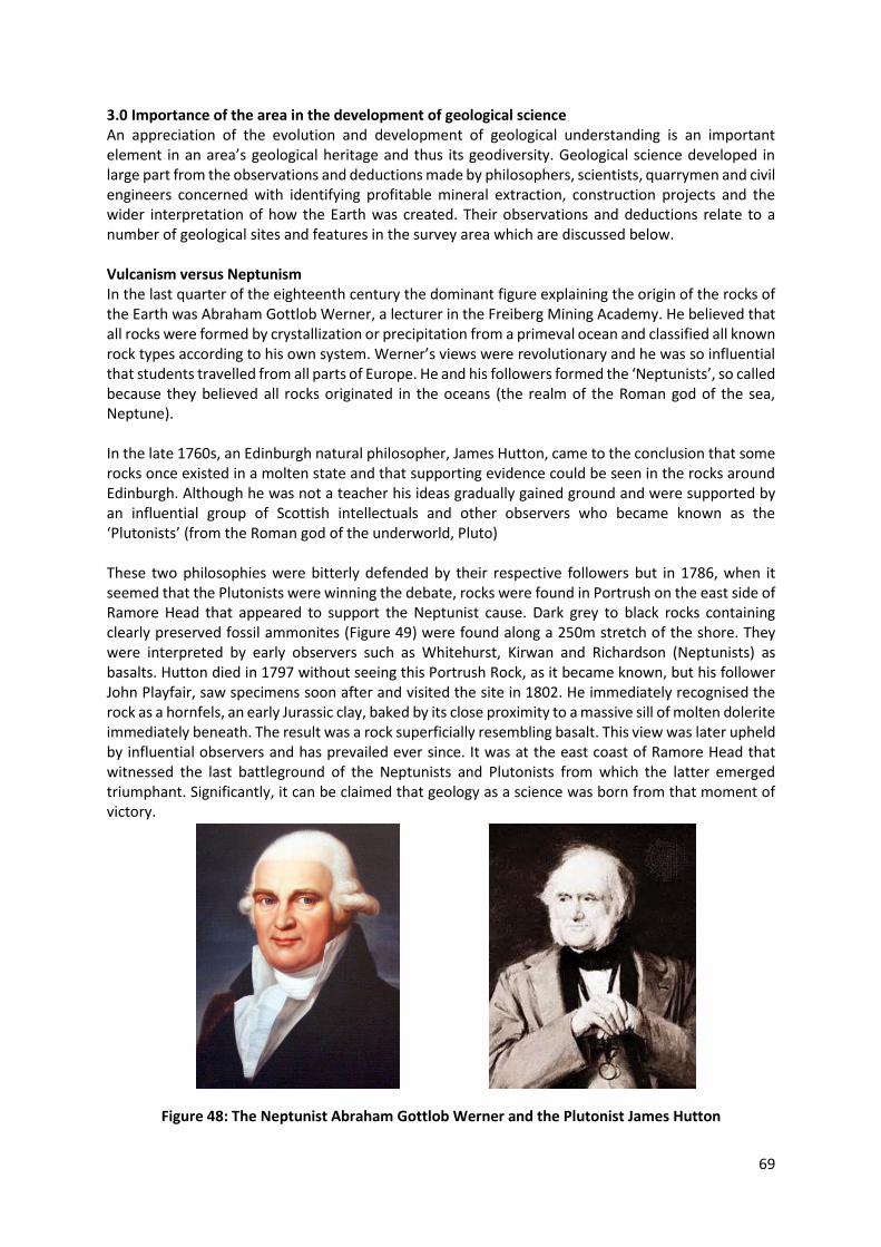
69
3.0 Importance of the area in the development of geological science An appreciation of the evolution and development of geological understanding is an important element in an area’s geological heritage and thus its geodiversity. Geological science developed in large part from the observations and deductions made by philosophers, scientists, quarrymen and civil engineers concerned with identifying profitable mineral extraction, construction projects and the wider interpretation of how the Earth was created. Their observations and deductions relate to a number of geological sites and features in the survey area which are discussed below. Vulcanism versus Neptunism In the last quarter of the eighteenth century the dominant figure explaining the origin of the rocks of the Earth was Abraham Gottlob Werner, a lecturer in the Freiberg Mining Academy. He believed that all rocks were formed by crystallization or precipitation from a primeval ocean and classified all known rock types according to his own system. Werner’s views were revolutionary and he was so influential that students travelled from all parts of Europe. He and his followers formed the ‘Neptunists’, so called because they believed all rocks originated in the oceans (the realm of the Roman god of the sea, Neptune). In the late 1760s, an Edinburgh natural philosopher, James Hutton, came to the conclusion that some rocks once existed in a molten state and that supporting evidence could be seen in the rocks around Edinburgh. Although he was not a teacher his ideas gradually gained ground and were supported by an influential group of Scottish intellectuals and other observers who became known as the ‘Plutonists’ (from the Roman god of the underworld, Pluto) These two philosophies were bitterly defended by their respective followers but in 1786, when it seemed that the Plutonists were winning the debate, rocks were found in Portrush on the east side of Ramore Head that appeared to support the Neptunist cause. Dark grey to black rocks containing clearly preserved fossil ammonites (Figure 49) were found along a 250m stretch of the shore. They were interpreted by early observers such as Whitehurst, Kirwan and Richardson (Neptunists) as basalts. Hutton died in 1797 without seeing this Portrush Rock, as it became known, but his follower John Playfair, saw specimens soon after and visited the site in 1802. He immediately recognised the rock as a hornfels, an early Jurassic clay, baked by its close proximity to a massive sill of molten dolerite immediately beneath. The result was a rock superficially resembling basalt. This view was later upheld by influential observers and has prevailed ever since. It was at the east coast of Ramore Head that witnessed the last battleground of the Neptunists and Plutonists from which the latter emerged triumphant. Significantly, it can be claimed that geology as a science was born from that moment of victory.
Figure 48: The Neptunist Abraham Gottlob Werner and the Plutonist James Hutton

70
Figure 49: Lias shales containing Ammonites subjected to hornfelsing by intrusive rocks The role of Rev. William Richardson (1740–1820)7 As noted above, in the 1700s there was some confusion as to the origin and nature of basalt and other igneous rocks such as granite - were they originally molten or precipitates from water? In 1740 Susanna Drury painted several views of Giant’s Causeway and engravings of these were distributed across Europe. Desmarest (Plutonist) declared on seeing them that the basalts were volcanic in origin, and in 1786 the Rev. William Hamilton (1755-1797), a fellow of Trinity College, Dublin, published an influential memoir which further advanced this standpoint. The igneous and plutonic theories were rejected by Richard Kirwan in 1799 in his book Geological Essays, as well as by the Rev. William Richardson the rector of Clonfeacle in County Tyrone and a former fellow of Trinity College. As he spent part of each year at Portrush, Richardson examined the ground for himself, and transmitted a steady stream of papers to the Royal Irish Academy that were published between 1802 and 1812. He claimed authority, as a resident, to make his views known but asserted not to subscribe to any theory or belong to any faction. Undoubtedly he was a Neptunist and argued against the volcanic origin of basalt on a number of grounds including:
1. There was no evidence of a volcanic mountain or cone in Antrim. 2. Plants are found developed on lava flows elsewhere but not in between the basalt layers. 3. The constituents of basalt and lava were different. 4. The layers of basalt were horizontal and regular in thickness. 5. The physical appearance of basalt and lava were different. 6. The contact relationships of basalt and lava were different. 7. The basalt was divided into regular masses while lava is found as an irregular mass. 8. The basalt of Portrush contained fossil marine shells (which he discovered in about 1799).
The last point is certainly the most significant, if basalt contained ammonites then it must be sedimentary. However, specimens of the ammonite-bearing stone were examined in Edinburgh by Sir James Hall and others who immediately recognised that they were not basalt but were a fine-grained dark sedimentary rock that had been baked by hot basaltic material which had resulted in its similar appearance to basalt. This swung the scales in the favour of the Vulcanists with additional support coming from later observations of columnar basalt in unequivocal lava flows. The debate was at an
7 Wyse Jackson P.N. (2009) Great Irish Geoscientists. GSI
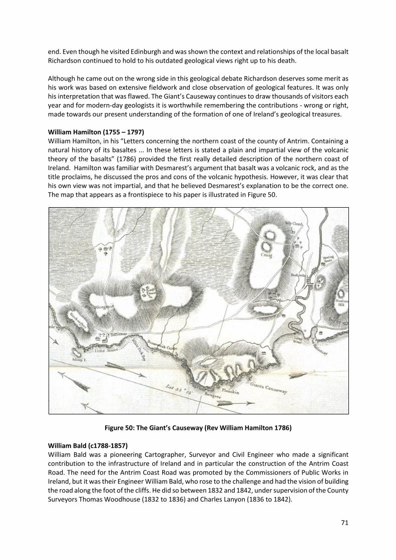
71
end. Even though he visited Edinburgh and was shown the context and relationships of the local basalt Richardson continued to hold to his outdated geological views right up to his death. Although he came out on the wrong side in this geological debate Richardson deserves some merit as his work was based on extensive fieldwork and close observation of geological features. It was only his interpretation that was flawed. The Giant’s Causeway continues to draw thousands of visitors each year and for modern-day geologists it is worthwhile remembering the contributions - wrong or right, made towards our present understanding of the formation of one of Ireland’s geological treasures. William Hamilton (1755 – 1797) William Hamilton, in his “Letters concerning the northern coast of the county of Antrim. Containing a natural history of its basaltes ... In these letters is stated a plain and impartial view of the volcanic theory of the basalts” (1786) provided the first really detailed description of the northern coast of Ireland. Hamilton was familiar with Desmarest’s argument that basalt was a volcanic rock, and as the title proclaims, he discussed the pros and cons of the volcanic hypothesis. However, it was clear that his own view was not impartial, and that he believed Desmarest’s explanation to be the correct one. The map that appears as a frontispiece to his paper is illustrated in Figure 50.
Figure 50: The Giant’s Causeway (Rev William Hamilton 1786)
William Bald (c1788-1857) William Bald was a pioneering Cartographer, Surveyor and Civil Engineer who made a significant contribution to the infrastructure of Ireland and in particular the construction of the Antrim Coast Road. The need for the Antrim Coast Road was promoted by the Commissioners of Public Works in Ireland, but it was their Engineer William Bald, who rose to the challenge and had the vision of building the road along the foot of the cliffs. He did so between 1832 and 1842, under supervision of the County Surveyors Thomas Woodhouse (1832 to 1836) and Charles Lanyon (1836 to 1842).

72
The skills and attention to detail brought to the project by Bald are best illustrated in the 1834 report of the scheme which provides drawings and plans of the project such as the cross-section illustrated in Figure 51. Bald’s report to the Commissioners in 1834 said ‘the work has two particular difficulties: one the necessity of constructing the road under a considerable extent of rock, and the other, its passage along portions of very steep hills of moving clay bank’. These difficulties are still evident today at the mud flows of Minnis, where the Lias clay flows down to the Coast Road as it has done for many centuries. In Bald’s day the scheme cost £37,140, upwards of £370 million in today’s market. On the Antrim Coast Road, just north of Larne, there is a memorial to Bald which reads: ‘Antrim Coast Road constructed 1832 to 1842 by the Men of the Glynnes under the direction of William Bald’.
Figure 51: Sketch from Bald’s report to the Commissioners of Public Works in 1834.
73
4.0 Assessment of key sites of geodiversity interest Although the protection and conservation of Geosites is a priority, before providing an assessment of the key sites of geodiversity interest within the audit area, it is also considered essential to establish a framework for selecting those sites that will bring the greatest benefits to the region balanced against any future capital and revenue investment. Although all geological and geomorphological sites in the Antrim Coast and Glens area have been reviewed both from an assessment of the existing site designation reports, literature and field notes held by NIEA, GSNI and others and from individual field visits, for the final selection of key sites for inclusion in the audit it has also been necessary to consider their value in terms of:
a. Economic value and tourism potential
b. Access conditions and recreational opportunities
c. Geoconservation challenges and opportunities
d. Education and learning opportunities
These criteria are discussed below and will be incorporated into the final Geodiversity Action Plan. 4.1 Factors contributing to Site Selection 4.1.1 Economic value and tourism potential The Giant’s Causeway and the Causeway Coast are Northern Ireland’s most iconic natural features that brings international awareness and market appeal to the destination. It is one of the most widely recognised landscapes and is directly associated with place promotion in Northern Ireland. As Northern Ireland’s primary visitor attraction and only World Heritage Site, it has the potential to act as a sign post location for directing visitors to other areas of geodiversity interest thus improving opportunities for maximising visitor spend. On this basis it could play a significant role for visitor dispersal in the wider Causeway Coast and Glens. According to the Causeway Coast & Glens Tourism Area Plan 2012-2017, the basis for visitor dispersal should be:
The quality of attractions in the area, but crucially too, of local communities and destination towns and villages. The momentum to improve the environment, facilities and interpretation in these local communities must continue;
Interpretation and orientation reinforcing reasons to visit local areas and why visitors should linger longer;
Continuing promotion of routes, trails and itineraries associated with public transport, walking, cycling etc;
Including and engaging local communities to help them see the benefit of being involved with and welcoming visitors
Any geosite selected must provide the visitor with a quality experience equal to that of the WHS. Such an approach may be to develop the Causeway Coast and Glens region as a Geopark. Geoparks, as an innovation for the protection of natural and geological heritage, play an important role in the development of geotourism. While developing geotourism, the establishment of geoparks can generate new job opportunities, new economic activities and additional sources of income, especially in rural regions8. It encourages the production of local products and local handicrafts involved in geotourism and geoproducts. Geotourism is only one of the core activities of geoparks, and in combination with educational activities is an increasingly important source of income for the
8 According to the European Geoparks Network (EGN) charter and Global Geopark Network regulations, all geoparks have to be established in rural areas (Zouros and Martini 2003); thus, geoparks and geotourism are opportunities for rural development, and they reduce the rate of unemployment and migration in rural areas.

74
local communities. Geoparks are pioneers in the development of geotourism; they stimulate socio-economic activities and sustainable development by attracting an increasing numbers of visitors. For example, McKeever (2010) described the creation of the Lesvos Petrified Forest European Geopark as transforming western Lesvos, attracting 90 000 visitors annually and employing 35 locals directly and with hundreds of new jobs having been created indirectly. The Geopark is now the island's main visitor attraction and is an excellent example of how the holistic approach to conservation used in Geoparks can be successful from the perspective of the local community. Possible geotourism activities can include:
Creation of thematic geo-museums and interpretation centres,
Exhibitions,
Exchange of know-how and best practice on geotourism development,
Creation of a geotourism database describing tourism activities offered by the Geoparks (museums and info-centres, trails, events etc.),
Organisation of geotourism activities in Geoparks i.e. exploring the geological history of the Geopark, nature observation, bird watching, conservation of fossils, mountain biking, trekking, rafting,
Organisation of working holidays in Geoparks and volunteer activities,
Organisation of conferences with a thematic focus on landscape, heritage interpretation and tourism,
Promotion of common geotourism packages and organisation of events promoting alternative tourism in Geoparks,
Exchange of information on geosite assessment, conservation and interpretation (e.g. publication of books and visitors guides, creation of interpretation panels, production of multimedia presentations and DVD’s) in order for visitors to explore the fascinating story preserved in the rocks and the landscape of the Geoparks.
Many of these activities have been identified as actions in the three AONB Management Plans, the WHS Management Plan and the Northern Ireland Tourist Board’s Causeway Coast and Glens Tourism Area Plan 2012‐2017 (see Section 1.6)
4.1.2 Access conditions and recreational opportunities Safe and secure site access is an essential prerequisite to making best use of the geodiversity of the Antrim Coast and Glens area. Good access to geosites will increase both their tourism and educational potential and will assist significantly in any future development of the region as a potential Geopark. Recent research into access provision within the Heart of the Glens Landscape Partnership area9 and on Rathlin Island10 has outlined much of the existing access resource within the region as well as detailing a number of opportunities for enhancing access to sites of heritage value. As part of the development of the Geodiversity Action Plan, it will be necessary to build upon this research and promote better access to the selected geosites. Consideration of land ownership, proximity to existing waymarked ways and ability to secure access agreements (either permissive path or by Public Right of Way) will strongly influence whether or not a geosite is incorporated into the final Action Plan.
4.1.3 Geoconservation Challenges and Opportunities
In Northern Ireland, Earth science features as well as natural and semi-natural ecosystems are formally designated under various national and international legislation and are protected and managed in order to conserve their special features. (See sections 1.6.5 to 1.6.13). These designations have different degrees of effectiveness in conserving, protecting and promoting local geodiversity with
9 ORNI (2012) Access to the Countryside Audit for the Heart of the Glens Landscape Partnership Scheme 10 ORNI (2012) Rathlin Island Access and Interpretation Audit

75
ASSIs offering the highest degree of protection. NIEA, through the ESCR, protect and monitor sites of geological importance and there are effective management structures in place for driving forward conservation actions established in both the AONB and WHS Management Plans. There is further opportunity to expand on this work through the development of a Geopark within the Causeway Coast and Glens area. Geoparks represent a positive development in the protection and promotion of geological heritage, and there has been a rapid growth and adoption of the concept not just in Europe, but internationally. Essentially, a Geopark is a territory with a well defined management structure in place (such as that adopted by the Giants Causeway and Causeway Coast WHS and the three AONB areas), where the geological heritage is used to develop sustainable tourism opportunities. A fundamental basis of the Geopark is that it is driven from the bottom up in that the communities in the Geopark are the drivers of the project and are the main beneficiaries. It therefore provides protection of the geological heritage resource so that the community benefits from it. Applications usually need to demonstrate some existing promotion of geological heritage and this Audit and Action Plan, alongside the extensive work carried out by the NIEA, GSNI and the WHS Officer and steering group along with the AONB Management groups may be useful in demonstrating the commitment.
4.1.4 Education and Learning Opportunities
Education is one of the most important elements of the WHS and AONB Action Plans and is of no less importance in the Geodiversity Action Plan. The teaching of geology has declined over the years to the extent that many universities, colleges and schools no longer include geology in their courses or curricula. It is therefore essential to ensure that key sites clearly illustrate, present and interpret all the Earth science events and processes evidenced in the area as far as possible. Education is considered here in five formal divisions. a. Pre-school & Primary education This covers ages 3-11 years includeing Key Stages 1 & 2 in the National Curriculum. This is one of the most important educational elements to tackle as children enthused with geology and related subjects at an early age have greater opportunity for developing their interests as their education progresses. b. Transition education This covers the transition from primary to secondary school. Teachers agree that enabling children to make a smooth learning transition between years 6 and 7 (KS2 to KS3) is desirable, but to set up useful and manageable systems can be challenging. This Audit and Action Plan will have the opportunity to develop, in conjunction with primary and secondary teachers a range of materials that will bridge the gap between KS2 and KS3. The materials will be field-based and cross-curricular. Key Stage 3 materials will build on skills developed at KS2. c. Secondary & Tertiary education This covers ages 11-18 years, Key Stages 3 and 4 in the National Curriculum. Particularly the science and geology elements including GCSE and A-level geology and geography. d. Higher education The Causeway Coast and Glens area has long been used by universities all over Britain for the teaching of geology as a field science. Although this use has declined perceptibly in recent years, many sites are still used regularly for geological teaching and by students learning geological mapping techniques. An aim of both the Action Plan is to increase this use, and encourage more university parties to stay longer.

76
e. Life-long learning Life-long learning is a growing element of education provision, and encompasses a highly diverse range of ages, abilities and social backgrounds. It includes formal provision in the form of courses run from educational establishments e.g. Open University, and informal provision in the form of events, presentations and publications facilitated by societies, clubs and trusts. It is important that the production of life-long learning materials is dovetailed with the strategy for geotourism products (Section 4.1.1). Following on from the promotion of Geotourism through the use of Geoparks as outlined in sections 4.1.1 and 4.1.3 Geoparks also promote themselves as destinations for educational activities. Geopark activities focus on young people, aiming at the promotion of a common European geological heritage as a factor for environmental understanding and sensitisation on nature protection. The main target group for Geoparks are schoolchildren and university students with the interpretation and information material produced being tailored to the needs of each age group. The wealth of Geodiversity across the Causeway Coast and Glens should therefore provide an opportunity to establish a cohesive and co-ordinated approach to Earth science education by developing a new learning strategy focused on quality sites.

77
4.2 Site Register The Site Register (Table 17) contains information on all the of geological and geomorphological sites of interest found within the survey area and provides a summary of their current use, access, educational opportunities and tourism potential and will help inform the future development and of Geodiversity within the Causeway Coast and Glens. Table 17: Site Register
Site Grid Reference
Summary Description Designations Ownership Current Use Existing Facilities Access Education Opportunities
Tourism Potential
Armoy Moraine X295429, X29782317, X30674328, X31084391
Armoy Moraine comprises a dominant feature of the local landscape that marks the southern extent of an advance of Scottish ice
AONB Multiple Agricultural None Private Yes – Reconstructing Deglacial phase
Low
Ballycastle Beach
D121415, D134415
Beach derived from deltaic sands of the Carey Valley
AONB Public Recreational Changing Facilities Public Yes – Interpreting sediment transfer
Medium
Church Bay, Rathlin Island
D148506 Gravel barrier of Midlandian age ASSI, SPA, SAC, AONB
Private Recreational None Public and Private Yes – Interpreting sea level change
Medium
Glenshesk Valley
D31434343 Moraine ridges and outwash plains AONB Multiple Agricultural Links with the Moyle Way
Public and Private. Yes – Reconstructing Deglacial phase
Medium
Loughaveema D207360 Glacial overflow channel and Vanishing Lake
AONB Private Agriculture Parking available south of bridge
Private Yes – Reconstructing Deglacial phase
Medium
Portmuck and Muck Island
D465025 Tombolo and Mineral resource ASSI, AONB Larne BC Recreational Car Park, Links with Coastal Path
Public Yes – Interpreting coastal deposition
High
Portballintrae C923423 Glacio-emergent sequence ASSI, AONB Public Recreational Car Park, Links with Causeway Coastal Path
Public Yes – Interpreting sea level change
High
Runkerry Strand, Bushfoot
C935427 Beach system ASSI, , AONB National Trust
Recreational Car Park, Links with Causeway Coast Way
Public Yes - demonstrating beach states from dissipative to reflective
High
Cliff/Shore Platform at Portstewart and Portrush
C815389, C85003995
Exposed Basalt Platforms AONB Public Recreational Car Park, Links with Causeway Coast Way
Public Yes – Interpreting sea level change
Medium
Grangemore and Castlerock Sand Dunes
C805355, C780361
Dune system with palaeosols ASSI, SAC, AONB
National Trust
Recreational None Public with restricted access at Grangemore
Yes – Reconstructing Holocene environments
High
Magilligan Complex
C665387 Dune system ASSI, SAC, AONB, NNR
Limavady Borough Council, MoD
Recreational Car Park and close to Benone Tourist complex
Public Yes – Reconstructing Holocene environments
High

78
Site Grid Reference
Summary Description Designations Ownership Current Use Existing Facilities Access Education Opportunities
Tourism Potential
Carey Valley D30074361, D31274408
Glacial delta ASSI, AONB Forest Service, Private
Agricultural None Private with Public Access at Ballypatrick Forest
Yes – Reconstructing Deglacial phase
Low
Portstewart Strand Sand Dunes
C805365 Dune and Beach system ASSI, AONB National Trust, Portstewart Golf
Recreational Parking on Beach Public Yes – Reconstructing Holocene environments
High
Carrickarade D062450 Tertiary volcano SAC, ASSI, AONB
National Trust
Recreational Car Park, Links with Causeway Coast Way, Rope Bridge
Public Yes – Interpreting early stages of volcanic activity
High
Craigahulliar Quarry
C883389 Quarry site Important for the diversity of basaltic and related rock types which include the lower of the Interbasaltic 'red beds' and the first flows of the Causeway Basalts
ASSI Coleraine BC Disused Quarry
None Private Yes – Interpreting basaltic rock types, lignite beds, fossils and unusual minerals
Low
Fairhead D180438 Tertiary Sill ASSI, AONB National Trust, Private
Recreational and agricultural
Causeway Coast Way
Public and Private Yes - Visible record of intrusion processes with transgression from Carboniferous to Cretaceous
High
Giant's Causeway and Causeway Coast
C947448 World Heritage Site WHS, ASSI, SAC, NNR, AONB
National Trust
Recreational Interpretative Centre, Car Park, Causeway Coast Way, North Antrim Cliff Path
Public Yes - Role in early debates on the origin of igneous rocks, its columnar basalts and associated materials
High
Little Deer Park Quarries, Glenarm
X33294149 Disused quarry in the Lower Basalt Formation containing zeolite minerals of potential interest
ASSI, AONB DRD Disused Quarry
None Private Yes – Mineral assemblage
Low
Rathlin Island D150510 Island with Basalt and Cretaceous Limestone exposures
ASSI (x4), SPA, SAC, AONB
RSPB, National Trust, Moyle DC, NIEA, Private
Residential, agricultural and recreational
Connected to Ballycastle by Ferry, accommodation, Car parking
Public and Private Yes – Interpreting feeder dykes
High
Skeagh and Craigcluggan
D302062, D294081
Volcanic Plug ASSI, AONB Private Agricultural None None Yes – Interpreting volcanic intrusions
Low
Slemish Mountain
D22150540 Volcanic Plug AONB Ballymena BC and Private
Agricultural and recreational
Car Park and Tourist Trail
Public Yes – Interpreting volcanic intrusions
High
Tardree Mountain
X31923941 Rhyolite lavas and associated volcanic vent rocks including obsidian, tuffs and agglomerate.
ASSI, AONB Private Agricultural None Private Yes – Interpreting lavas
Low

79
Site Grid Reference
Summary Description Designations Ownership Current Use Existing Facilities Access Education Opportunities
Tourism Potential
Tievebulliagh D31944268 Unusual inclined volcanic conduit through the Tertiary basalt lavas
ASSI Private Agriculture Farm Track Private Yes – Mineral assemblages
Medium
Binevenagh C690310 Basalt escarpment and rotational slips
ASSI, SAC, AONB, NNR
Limavady BC and Private
Agriculture and Recreation
Viewing Point, Car Parking
Public and Private Yes – Geomorphic interpretation
High
Capecastle Quarry
D101364 Quality exposure of Ulster White Limestone Formation
ASSI, AONB Private Quarry None Public Yes - history of chalk sedimentation over Dalradian ridge
Low
Creggan Quarry D277187 Type section of Creggan Chalk Member of Ulster White Limestone Formation
ASSI, AONB Private Quarry None Private Yes - Illustrative of chalk sedimentation in Larne-Lough Neagh Basin
Low
Dunnaglea-Larry Bane Bay
D033451, D059448
Type sections for three of the Campanian members of the Ulster White Limestone Formation
ASSI, AONB National Trust
Recreational Carpark at Ballintoy Harbour and National Trust carpark at Carrick-a-Rede. Part of the Causeway Coast Way
Public Yes - History of chalk sedimentation in the Rathlin Basin
Medium
Garron Plateau Blanket Bog ASSI, SAC, AONB, RAMSAR
Private Agriculture and Recreation
Ulster Way, Antrim Hills Way, The Moyle Way
Public and Private Yes – Peatland studies Medium
Garron Point-Cloghastucan
D289253, D305234
Extensive landslips ASSI, SAC, AONB, RAMSAR
Private Agriculture Car Park Private Yes – Geomorphic interpretation
Medium
Glenarm Quarry D304156 Type section for Glenarm Chalk Member of Ulster White Limestone Formation
ASSI, AONB Private Quarry None Private Yes – History of chalk sedimentation in Larne-Lough Neagh Basin.
Low
Murlough Bay D2142 Cretaceous basal conglomerates exposed beneath Ulster White Limestone cliffs.
AONB National Trust
Recreational Church car park Private Limited – exceptional views
High
Port Calliagh-Ballycastle
D109420, D120416
Quality exposures of type sections for Port Calliagh Chalk and Ballycastle Chalk Members of Ulster White Limestone Formation. Also youngest Cretaceous strata in Northern Ireland
ASSI, AONB Private Agricultural Narrow path Private Yes - History of chalk sedimentation in the Rathlin Basin
Medium
White Rocks C888408, C903413
Type sections for the Portrush, Ballymagarry and Tanderagee Chalk Members of the Cretaceous Ulster White Limestone Formation. Evidence of Tertiary explosive vent
ASSI, SAC, AONB
Coleraine BC Recreational Car parking and toilets
Public Yes - Best example in Ireland of coastal landforms - cliff, shore platforms, caves, arches, and sea stacks.
High
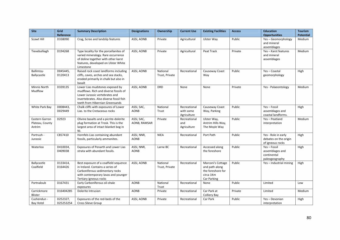
80
Site Grid Reference
Summary Description Designations Ownership Current Use Existing Facilities Access Education Opportunities
Tourism Potential
Scawt Hill D338090 Crag, Scree and landslip features ASSI, AONB Private Agricultural Ulster Way Public Yes – Geomorphology and mineral assemblages
Medium
Tievebulliagh D194268 Type locality for the porcellanites of varied mineralogy. Rare occurrence of doline together with other karst features, developed on Ulster White Limestone
ASSI, AONB Private Agricultural Peat Track Private Yes – Karst features and mineral assemblages
Medium
Ballintoy-Ballycastle
D045445, D120413
Raised rock coast landforms including cliffs, caves, arches and sea stacks, eroded primarily in chalk but also in basalt
ASSI, AONB National Trust, Private
Recreational Causeway Coast Way
Public Yes – Coastal geomorphology
High
Minnis North Mudflow
D339135 Lower Lias mudstones exposed by mudflows. Rich and diverse fossils of Lower Jurassic vertebrates and invertebrates. Also diverse fossil fish teeth from Hibernian Greensands
ASSI, AONB DRD None None Private Yes - Palaeontology Medium
White Park Bay D008443, D029449
Chalk cliffs with exposures of Lower Lias. to the Cretaceous rocks
ASSI, SAC, AONB
National Trust
Recreational with some Agriculture
Causeway Coast Way, Parking
Public Yes – Fossil assemblages and coastal landforms.
High
Eastern Garron Plateau, County Antrim
D2923 Olivine basalts and a picrite-dolerite plug formation at Trosk. This is the largest area of intact blanket bog in NI.
ASSI, SAC, AONB, RAMSAR
Private Recreational and Agriculture
Ulster Way, Antrim Hills Way, The Moyle Way
Public Yes – Peatland interpretation
Medium
Portrush - Jurassic
C857410 Hornfels Lias containing abundant fossils, particularly ammonites.
ASSI, NNR, AONB
NIEA Recreational Port Path Public Yes - Role in early debates on the origin of igneous rocks
High
Waterloo D410034, D409038
Exposures of Penarth and Lower Lias strata with abundant fossils.
ASSI, NNR, AONB
Larne BC Recreational Accessed along the foreshore
Public Yes – Fossil assemblages and continental paleogeography
High
Ballycastle Coalfield
D133414, D164426
Best exposure of a coalfield sequence in Ireland. Contains a series of Carboniferous sedimentary rocks with contemporary lavas and younger Tertiary igneous rocks
ASSI, AONB National Trust, Private
Recreational Marconi's Cottage and path along the foreshore for circa 1Km Car Parking
Public Yes – Industrial mining High
Portnaloub D167431 Early Carboniferous oil-shale exposures
AONB National Trust
Recreational None Public Limited Low
Carrickmore Blister
D16404285 Dolerite Intrusion AONB Private Recreational Car Park at Colliery Bay
Private Limited Medium
Cushendun - Bay Hotel
D252327, D25253254
Exposures of the red-beds of the Cross Slieve Group
ASSI, AONB Private Recreational Car Park Public Yes – Devonian interpretation
High

81
Site Grid Reference
Summary Description Designations Ownership Current Use Existing Facilities Access Education Opportunities
Tourism Potential
Cushendun to Port Obe
D252326, D247289
Cliff and shore sections between Cushendun and Cushendall exposing three formations of the Cross Slieve Group
AONB Moyle DC Recreational Car Parking, Toilets
Public Yes – Devonian interpretation
High
Cushendall to Red Arch, Glenariff
D244276, D243261
Sedimentary rocks of the Red Arch Formation exposed in an almost continuous section between Cushendall and Waterfoot
AONB Moyle DC, Private
Recreational Car Parking, Toilets
Public Yes – Devonian interpretation
High
Lifeboat House, Cushendall
D244269 A variety of red conglomerates, extending along 400m of coast southwards from Lifeboat Station
AONB Moyle DC Recreational Car Parking, Toilets
Public Yes – Devonian interpretation
High
Port Obe, Cushendall
D24702882 Exposures of coarse pink sandstones of Ballyagan Formation and basal beds of Cushendall Formation.
AONB Private Recreational Car Parking Public Yes – Devonian interpretation
High
Red Arch and coastal exposures, Waterfoot
D244262 Exposures of pink sandstones and conglomerates of Red Arch Formation
AONB Private Recreational Car Parking Public Yes – Devonian interpretation
High
Red Arch, Waterfoot
D24352630 Cross-stratified and imbricate pebbly sandstones
AONB Moyle DC Recreational Car Parking, Toilets
Public Yes – Devonian interpretation
High
Altmore Burn D233398 Outcrops of coarse quartz-feldspar grit and psammite lithologies of the Altmore Formation
AONB National Trust
Agricultural None Private Yes – Precambrian stratigraphic correlation
Low
Benvan D205415 Precambrian outcrops of representative strata of Owencam Formation
ASSI, AONB National Trust
Agricultural and Recreational
Track from Torr Road
Public Yes – Precambrian stratigraphic correlation
Medium
Carnaneigh D256365 Stratotype exposures for the Carnaneigh Green Bed Member
ASSI , AONB Private Agricultural and Recreational
Track from Torr Road
Public Yes – Precambrian stratigraphic correlation
Medium
Cushendun Bay and Rock Port
D252335 Folded and cleaved metasedimentary rocks cut by quartz-feldspar porphyry veins related to the nearby Cushendun Granite
ASSI, AONB National Trust
Recreational Car Parking Public Yes – Precambrian stratigraphic correlation
High
Escort Port D227407 Representative strata of the Torr Head and the Owencam Formations
ASSI, AONB National Trust
Agricultural None Private Yes – Precambrian stratigraphic correlation
Low
Knocknacarry Bridge, Cushendun
D240327 Psammite and albite schist’s of the Glendun Formation
ASSI, AONB Private Agricultural and Riverine
Fisherman’s Path Public Limited Low
Leckpatrick Point
D225397 Exposure of stratotype of Leckpatrick Green Bed Member, defining the stratigraphic base of Runabay Formation
ASSI, AONB National Trust
Recreational None Public Yes – Precambrian stratigraphic correlation
Low

82
Site Grid Reference
Summary Description Designations Ownership Current Use Existing Facilities Access Education Opportunities
Tourism Potential
Loughan Bay D242383 Outcrops of siliclastic and volcanogenic lithologies of Runabay Head Formation
ASSI, AONB National Trust
Agricultural None Private Yes – Precambrian stratigraphic correlation
Low
Torr Head D234406 Key marker of Dalradian in NE Antrim. Best exposure of Middle-Upper Dalradian boundary. Torr Head is notable for being the type locality of the Torr Head (Limestone) Formation.
ASSI, AONB National Trust
Agricultural Car Parking, Poor quality path
Public Yes – Precambrian stratigraphic correlation
High
4.3 Description of Key Geodiversity Sites of Importance Following from the review of all the sites of Earth science importance within the Causeway Coast and Glens, the following sites have been selected for further discussion based upon:
a. Their geological and geomorphological significance b. Their place in the geological evolution of the area c. Their importance in the development of geological science d. Their designation as a quality site e. Their potential to contribute to the future development of a Geopark f. Their educational and tourism potential g. Their consideration in existing Strategies and Action Plans h. Their accessibility
It is anticipated that these sites will play a significant role in promoting, protecting and conserving Geodiversity in the area and will take a central role in the Geodiversity Action Plan. A list of potential opportunities for promoting and accessing geodiversity at each site have also been included. These are only indicative and can be expanded and developed. 4.3.1 Torr Head Period of Formation: Precambrian The quartz schist’s of the Murlough Bay formation are the oldest Dalradian beds exposed in North East Antrim and are part of the Argyll Group of the Dalradian Supergroup. At Torr Head are two younger formations, the Torr Head Limestone Formation and the overlying Altmore Formation, which consists mostly of coarse grain psammites and grits. At Torr Head this succession is upside down because of extensive folding with the overturned contact between the two visible on the south side of the headland. (Mitchell, 2004). These rocks are of international importance as they provide a key in understanding the geological history and relationship both here in Northern Ireland and in Scotland. They form part of the complex known as the highland border ridge which runs right across Scotland. Opportunities
Research into Dalradian stratigraphy
Upgrade access from coastguard station
Improve interpretation including signage, guide brochure and web link
Incorporate into long distance geotrail 4.3.2 Fairhead to Murlough Bay Period of Formation: Precambrian, Triassic, Cretaceous, Carboniferous and Palaeogene A diverse range of geology can be viewed including all three igneous, sedimentary and metamorphic rock types at Murlough Bay. The oldest rocks occur at the eastern side of the bay and are Dalradian schists, which are just over 600 million years old. Red sandstone dating from the Triassic Period overlies the schists, and the boundary between the two is an unconformity representing a gap of some 350 million years. A second unconformity, is seen where Cretaceous white limestone overlies the Triassic sandstones. A conglomerate is found at this unconformity containing fossils of Jurassic age. Fair Head itself is a body of igneous rock which pushed its way through older Carboniferous rocks forming a sill. The sill is made of a dark green-black, medium grained dolerite that displays columnar structure similar to those seen at the Giant’s Causeway.
Opportunities
Improve interpretation including signage, guide brochure and web link
Incorporate into long distance geotrail

84
4.3.3 Cushendall to Waterfoot Period of Formation: Devonian This area incorporates a number of sites that display a range of sedimentary mudstones and sandstones from the Devonian period. Red Arch formation conglomerates and sandstones were deposited on an alluvial fan. The top surface of the pale green mudstone exhibits large scale desiccation cracks. This is indicated through the change in grain size of the sandstone from fine to coarse. Here a wave cut platform shows conglomerate beds and coarse sandstones of the lowest part of the Red Arch Formation. From Cushendall to the eastern shore of Glenariff, red conglomerates and sandstones can be seen all along the coastline Opportunities
Research into Devonian stratigraphy
Design and construct the Red Arch Trail from Cushendall to Waterfoot
Improve interpretation including signage, guide brochure and web link
Incorporate into long distance geotrail 4.3.4 Cushendun Period of Formation: Devonian The oldest Devonian rocks in the area are to be found at Cushendun were thick beds of Boulder conglomerates are exposed in the cliffs and sea caves at Cave House. These beds of the Cushendun Formation contain abundant quartzite pebbles with occasional sandstone and mudstone beds which were produced in alluvial fans in a desert environment. Opportunities
Research into Devonian stratigraphy
Upgrade access from Bay view carpark along coastal section to cave
Improve interpretation including signage, guide brochure and web link
Incorporate into long distance geotrail 4.3.5 Ballycastle Coalfield Period of Formation: Carboniferous The Ballycastle area is the only coastal location of Carboniferous coal deposits in Ireland. Cliff sections between Pans Rock and Carrickmore expose the upper part of the succession with strata becoming older from west to east due to minor faults and down-throw to the west. The lowest unit of the Ballycastle Group, the Eglish Sandstone Formation rests unconformably on the Dalradian and is exposed at Murlough Bay. The Carey River Formation is exposed in the roadside cliff at Pan’s Rock while the Glenshesk Tuff Formation is visible on the shore west of Fair Head. The Ballyvoy Sandstone Formation is exposed on the cliffs between Ballycastle and Fair Head. This area represents one of the most accessible coal seams in Ireland with horizontal mining recorded from the 13th Century until 1950s (Hamond 1991). This is also the only place where Carboniferous Oil Shales can be seen in Ireland and one of three where broken fish remains can be found in Northern Ireland. As well as coal there are also thin seams of iron-rich ore Blackband ironstone. Opportunities
Research into industrial and mining heritage of Ballycastle
Establish a written and visual archive of mining in Ballycastle
Develop the Ballycastle Coal Trail
Improve interpretation including signage, guide brochure and web link
Incorporate into long distance geotrail
85
4.3.6 Waterloo Foreshore, Larne Period of Formation: Triassic and Jurassic This site exposes the transition between the Triassic and Jurassic periods. The Triassic rocks, from the oldest and deepest upwards, comprise the reddish-brown lime-rich mudstones of the Port More Formation, topped by greenish-grey but otherwise similar rocks of the Collin Glen Formation, surmounted by the grey shales and mudstones of the final, Rhaetian stage of the Triassic. These Rhaetian rocks then pass indistinguishably into grey mudstones at the base of the Jurassic to be followed by more grey mudstones with thin limestones. The lower third of the Jurassic period is called the Liassic, often abbreviated to Lias, and all the Jurassic rocks at Larne are part of the Waterloo Mudstone Formation, which is part of the earliest Lower Lias. The red and grey-green mudstones of the Triassic were deposited in shallow lakes in desert lowlands. During the Rhaetian, the sea began to flood into these lowlands and, at Larne, beds crowded with the small marine bivalve, crinoids and ammonites. Opportunities
Develop the Larne Fossil Trail
Improve interpretation including signage, guide brochure and web link
Produce a fossil guide
Incorporate into long distance geotrail 4.3.7 Portrush Sill Period of Formation: Jurassic and Palaeogene Portrush is situated on a large igneous dolerite sill intruded during the Palaeogene, which altered the former Jurassic mudstone. This is an internationally important locality in the history of geological study as it caused much debate during the 18th Century between two schools - the Neptunists and the Vulcanists. Neptunists believed that basalt precipitated out of sea water, whilst Vulcanists believed that it was the result of volcanic activity. The occurrence of ammonites, in what Neptunists believed was basalt, supported their theory. However the Vulcanists were able to show that although these rocks closely resembled basalt, they were in fact sedimentary rocks, which as a result of the heat from molten lava, had been baked and metamorphosed into a different rock type known as hornfels. Opportunities
Develop the Portrush Dolerite Trail
Improve interpretation including signage, guide brochure and web link
Produce a fossil guide
Incorporate into long distance geotrail 4.3.8 White Park Bay Period of Formation: Jurassic and Cretaceous White Park Bay contains important exposures of the Waterloo Mudstone Formation together with excellent outcrops of the Hibernian Greensands Formation and Ulster White Limestone Formation including the Oweynamuck Flint Band, the Bendoo Pebble Bed and the Altachuile Breccia. The exposures of Mesozoic rocks at White Park Bay are typical of the Rathlin Basin. The Waterloo Mudstone Formation found here is rarely exposed in north Antrim and these outcrops have provided a diverse fauna. The lowest members of the Ulster White Limestone, the Galboly Chalk, Cloghastucan Chalk including the Oweynamuck Flint Band are well exposed and very accessible. The ground behind the beach and dunes is uneven because of numerous land-slipped blocks. After the last glacial period when the Scottish ice had retreated, the cliffs here were left in a seriously oversteepened state. This coupled with the soft clay underlying the chalk caused instability in this area. Opportunities
Improve interpretation including signage, guide brochure and web link
Produce a fossil guide
Incorporate into long distance geotrail

86
4.3.9 White Rocks, Portrush
Period of Formation: Cretaceous and Palaeogene The Cretaceous rocks along the coastline east of Portrush were formed in the second half of the Campanian and at the start of the succeeding Maastrichtian stage. The White Rocks area exposes up to seven of the fourteen Ulster White Limestone Formation divisions (the Ballintoy, Glenarm, Garron, Portrush, Ballymargarry, Tanderagee, and Port Calliagh Chalk Members). Three of these members are of particular importance in this area, the Portrush Chalk, the Ballymargarry Chalk and the Tanderagee Chalk. The White Rocks demonstrate classic coastal landforms including chalk - cliff, shore platform, cave, arch, and sea stack. The chalk landforms are best developed in two locations at either end of the site. At the western (Curran Strand) end, flanking the Slidderycove Point promontory, there are a number of deep rectilinear caves and an impressive arch. Here also a number of sea stacks sticking up from the sand. Some of these are composed of chalk which has been shattered and recemented. Large blocks of basalt are sometimes embedded in this material. At the eastern (Dunluce) end of the site is Gulls Point Arch with a basalt cap. Associated with this arch are a number of caves, smaller incipient arches, and sea stacks. Opportunities
Key Stage 2 and 3 work books
Improve interpretation including signage, guide brochure and web link
Incorporate into long distance geotrail 4.3.10 Ballintoy Period of Formation: Cretaceous At Ballintoy Harbour the cliffs of Cretaceous chalk have been slightly baked by the volcanic feeder now forming the Bendoo Plug (exposed on the cliff top just south of the harbour). The upper level of the cliff was previously quarried for lime, which was burnt in the kilns adjacent to the access road. The cliff is fronted by a previous marine erosion platform now 4-5m above sea level. This beach continues west towards White Park Bay and exhibits a variety of raised beach caves, stacks and arches cut into both chalk and basalt. Opportunities
Upgrade to coastal path
Key Stage 2 and 3 work books
Research into the industrial heritage
Improve interpretation including signage, guide brochure and web link
Incorporate into long distance geotrail 4.3.11 Giant’s Causeway Period of Formation: Palaeogene Geological succession at the Giants Causeway covers the Lower and Middle Basalts and the lower of the two Inter-basaltic Beds of the Antrim Lava Group (Figure 24). The Lower Basalts are a series of up to 11 complex, olivine-rich flows that are largely medium grained in texture. Typically flows consist of a thin basal vesicular layer, a compact middle layer and a thick vesicular top. Individual flows are on average some 7m thick and can be separated by layers of consolidated and weathered wind-blown dust or by narrow layers of weathered basalt that can be topped by a thin lignite deposit. The Lower Basalts are best seen beneath the Inter-Basaltic Bed in the coastal section to the east of the Causeway at Plaiskin and Benbane heads. The Giant’s Causeway has played a critical role in the development of scientific ideas concerning the nature of key geological processes. The importance of the site in the advancement of volcanology concepts since the 18th Century is evidenced in the wealth of research literature published about the site. Today the WHS continues to represent an internationally renowned case study site for both teaching and exploration of geological and geomorphological processes. Future geological and
87
geomorphological research into the site's outstanding universal value will positively contribute to site management and monitoring regimes. Opportunities
The WHS site is key to the dispersal of visitors to other sites of geodiversity interest and would act as the core feature in the establishment of a Geopark
Research into Palaeogene geology, coastal geomorphology, climate change and visitor management
Teaching resources for KS 1 to KS 4
Development of training programmes in site conservation and management
Incorporate into long distance geotrail 4.3.12 Rathlin Island Period of Formation: Cretaceous, Palaeogene and Quaternary The geological structure of Rathlin Island consists of a foundation of Ulster White Limestone topped by lavas of the Antrim Basalts. The basalts immediately above the contact belong to the Lower Basalt Formation that breached the Cretaceous land surface around 62 million years ago laying down extensive lava flows. Above this are the lavas of the Causeway Tholeiite Member, the main columnar lavas of the Giant’s Causeway. Rathlin also displays evidence of post-glacial sea-level changes and isostatic uplift. Both were due to the melting and retreat of Scottish ice. The melting initially raised sea-level but this was followed by the rise of the landscape due to it being unloaded of this ice The interaction of these processes created the platforms and raised beaches seen at various places around the island including Church Bay. Opportunities
Develop new trails as recommended by ORNI (2012)
Improve interpretation including signage, guide brochure and web link
Incorporate into long distance geotrail 4.3.13 Carrickarede Period of Formation: Palaeogene Carrickarede is the remains of an explosive volcano which is unique in its extent in the whole of the Tertiary igneous province of northeast Ireland. The remaining volcanic dolerite plug also consists of exposures of agglomerate comprising fragments of basalt, chalk and lias clay ejected during the initial explosive phase of the Antrim Lavas Opportunities
Upgrade works to the Causeway Coast Way
Improve interpretation including signage, guide brochure and web link
Incorporate into long distance geotrail 4.3.14 Slemish Mountain Period of Formation: Palaeogene Slemish is the largest of the Antrim volcanic plugs and shows evidence of repeated use as a feeder vent and preserves the structures indicative of a lava lake in the old volcanic crater. Opportunities
Improve interpretation including signage, guide brochure and web link
Incorporate into long distance Geotrail

88
4.3.15 Binevenagh Period of Formation: Palaeogene The basalt scarp at Binevenagh represents the north-western limit of the Antrim Lava Group and is exposed from the north coast at Downhill and Castlerock, southwest to Binevenagh and then in a generally southerly direction to the hills around Benbraddagh near Dungiven. The succession at Binevenagh consists of around 100m of basalts overlying Cretaceous Chalk. The base of the succession contains a number of flows made up of thin flow units. These flows pass up into a number of prominently columnar flows separated by distinctive red boles and the upper flows in the sequence are olivine-phyric with convoluted flow banding. A feature of the base of the Binevenagh cliffs is the presence of extensive slipped masses of basalt overlying Cretaceous, Liassic and Triassic rocks. Opportunities
Research into rotational slips
Develop a new trail between Binevenagh and Donald’s Hill
Upgrade viewing point
KS 3 and KS 3 workbooks
Improve interpretation including signage, guide brochure and web link
Incorporate into long distance geotrail 4.3.16 Portballintrae Period of Formation: Quaternary The glacio emergent sequence at Portballintrae demonstrates that the environmental signature of the deglacial to late glacial transition was one of rapid local environmental changes driven by rapid rates of isostatic rebound, differential tectonics and eustatic changes. The marine sands contain a wide range of wave-influenced sedimentary structures which have not been described from glacigenic sequences in the UK. Opportunities
Research into Quaternary sea level change and reconstruction
Research into conservation of soft coastal exposures
Improve interpretation including signage, guide brochure and web link
Incorporate into long distance geotrail 4.3.17 Magilligan Foreland Period of Formation: Quaternary The triangular expanse of Magilligan is made up of over 150 beach ridges with subsidiary aeolian deposits and inter-ridge peats and marls. The site is an important element in the sea-level history of Ireland, while its distal extremity, Magilligan Point, is an especially important geomorphological site as it demonstrates the relatively unusual phenomenon of prograding dunes. Opportunities
Improve interpretation including signage, guide brochure and web link
Incorporate into long distance geotrail

89
5. Connections with landscape and biodiversity, built and cultural heritage 5.1 Geodiversity Connections with local biodiversity The geological and geomorphological foundations of the North Coast and Antrim Glens provide a range of conditions which have led to the development of a rich and biologically diverse series of marine and terrestrial ecosystems. Geodiversity has a fundamental role in supporting habitats, species and landscape character, and in providing essential ecosystem and environmental services in the area. Rocks, landforms and soils form the foundations upon which plants, animals and human beings live and interact. Geodiversity is the foundation of all terrestrial ecosystems and delivers key biogeochemical processes, mass and energy flows and exchanges with atmospheric and hydrological systems. The geomorphological processes that shape the mountains, rivers and coast also maintain dynamic habitats and ecosystems. The biodiversity of the Causeway Coast and Glens depends on the continued operation of these processes. Management of sites for biodiversity requires an understanding of their geological and geomorphological setting and current process dynamics. Many habitats owe their origins to geological and geomorphological processes e.g. Magilligan sand dune systems. Active geomorphological processes also maintain dynamic habitats and ecosystems through sediment and water flows, nutrient cycling and hydrology. Maintaining natural process systems is a key part of conserving biodiversity as well as maintaining the natural landscape. The biodiversity of the Causeway Coast and Glens depend on the continued operation of these processes. In the past this functional role has tended to be overlooked in conservation management however, it is increasingly recognised that conservation management of the non-living parts of the natural world is crucial for sustaining living species and habitats (Hopkins et al 2007). From a natural heritage viewpoint, this requires a more integrated approach to nature conservation and the management of sites and landscapes, recognising:
i) The value of geodiversity as an intrinsic constituent of the natural heritage alongside other aspects of biodiversity and landscape character
ii) The role of geodiversity in supporting and regulating a wide range of environmental and ecological services essential for supporting habitats and species.
Traditional approaches in conservation management have however, focused on species and protected areas, usually neglecting wider ecosystem functions and links. Conservation management in Great Britain has tended to treat geodiversity and biodiversity separately and there has generally been a lack of spatial integration (e.g. at coastal zone and river catchment scales) based on knowledge of geomorphological process systems and ecosystems that help to maintain dynamic habitats, ecosystems and landscapes (Gordon et al., 1994). Awareness of the temporal dimension has also been neglected in that ecosystems are not fixed and stable but are continually adapting to changes in geomorphological processes over large timescales in response to a range of natural and human drivers. To understand how ecosystems respond to change, it is crucial to think in terms of geomorphological processes and their changes over both space and time. The importance of these current natural processes and the value of more integrated approaches in land and water management is now becoming more widely recognised for sustaining natural habitats for example the Convention on Biodiversity and the European Landscape Convention both call for a more integrated approach to the conservation of living species, habitats and landscapes, both within and beyond protected areas. Such approaches incorporate the dependencies between geodiversity

90
and biodiversity. In particular, both the Millennium Ecosystem Assessment11 and ecosystem approach12’ focus on structure, processes, functions and interactions. The ecosystem approach acknowledges that natural change is inevitable and that management should be conducted at appropriate spatial and temporal scales. Increasingly, too, a multifunctional approach to soil conservation and sustainable management of soil resources is addressing habitat support and delivery of other ecosystem services. The potential contribution of geodiversity to sustainable management of land and water at a landscape/ecosystem scale, including adaptations to climate change and sea-level rise, is now recognised in Integrated Coastal Zone Management, Integrated Catchment Management and Sustainable Flood Management. Functional links between soil and other aspects of geodiversity are also included in recent development of the EU and national soil strategies. In particular, this involves understanding and working with natural processes in a sustainable, spatially integrated manner. For example, this may include options for adapting to climate change through natural flood management techniques, including river and coastal management. It is therefore clear that conservation management for habitats and species cannot succeed without reference to the underlying geology, soils and geomorphological processes. Understanding the functional links between geodiversity and biodiversity is particularly important in dynamic environments, where natural processes including floods, erosion and deposition maintain habitat diversity and ecological functions (Gordon & Leys, 2001; Hopkins et al 2007, Wignall, 2007). For example, understanding the links between geodiversity and biodiversity is fundamental to integrated conservation management in the uplands. Upland habitats are generally of high value for nature conservation but are dynamic and often fragile, as at Garron or Slievanorra. This dynamism and fragility result from the properties of the soils and vegetation, geomorphological processes and the extreme climate. Landscape sensitivity and thresholds for change (e.g. acceleration of soil erosion and consequent loss of habitats) depend on the interactions of these factors and human pressures These links are explicit in the ‘ecosystem approach’. Such an approach linking geodiversity and biodiversity is timely and applicable to a number of cross-cutting issues including the management of habitats and natural system responses for adaptations to climate change, river/floodplain restoration for sustainable flood management, coastal management and habitat/landform adaptation to projected sea-level rise, soils and habitat restoration and multifunctional management of peatlands for habitat and carbon sequestration interests. Geodiversity processes strongly influence the condition of many habitats and species and their abilities to adapt to the impacts of climate change and other anthropogenic pressures and land-use changes. Better understanding of the dynamic relationships between geodiversity and biodiversity will help to inform management and/or restoration options for mitigation and adaptation to such changes. Therefore, more joined-up working is required to develop better understanding of the linkages between geodiversity and biodiversity, particularly with regard to managing ecosystems in the context of climate change and sea-level rise, which are likely to have far-reaching effects on local landscapes if current projections are borne out.
11 The Millennium Ecosystem Approach is an international work program designed to meet the needs of decision makers and the public for scientific information concerning the consequences of ecosystem change for human well-being and options for responding to those changes (www.unep.org) 12 An ecosystems approach provides a framework for looking at whole ecosystems in decision making, and for valuing the ecosystem services they provide, to ensure that society can maintain a healthy and resilient natural environment now and for future generations. (DEFRA)

91
All councils within the Causeway Coast and Glens catchment have produced Biodiversity Action Plans with associated Species and Habitat Action Plans. Although recognising the need for conservation and protection of habitats, many of these plans do not consider the influence of local geology and geomorphology and the dynamic influence these have. As part of future monitoring of these plans, it is essential that the influence of geology and geomorphology be incorporated as part of their review. 5.2 Geodiversity connections with the Built Heritage The built environment includes houses, farms, churches, graveyards, schools and other public, industrial and commercial buildings, roads and highway structures. In the context of the study area it embraces castles, historic monuments and churches through to modern buildings. Where natural materials have been employed in their construction, all may legitimately be viewed as components of the area’s geodiversity. The nature and appearance of stone-built structures in any area is directly related to the physical characteristics of the available rocks and the constraints those characteristics may impose on their potential use as constructional materials. Whereas it is generally appreciated that the character of local buildings is an important element in determining the character of a landscape, it may not be so readily appreciated that those buildings, and the material they contain, must be viewed as key components of the area’s geodiversity. Built structures thus provide readily accessible opportunities to demonstrate the characteristics of a variety of local rock types. All of the geological materials employed in built structures can contribute greatly to an appreciation of the importance of the Earth’s resources through understanding the properties and limitations of these materials. They are thus a potentially valuable educational resource. The Natural Stone Database13 for Northern Ireland developed by Queen’s University Belfast and others provides key information and images on building stone used on listed buildings and monuments throughout the survey area, as well as the quarries (active and inactive) from which the stone was extracted. For further information on rock used in buildings of the area can be found at the referenced website. Despite the varied geology of the audit area, the range of rock types suitable for building is rather restricted. The main rock types employed are: Basalt This is the most commonly used stone in the region. Most of the Basalt used has been derived from the Upper Basalt Formation and obtained either from quarries opened in the nearest available outcrop or from clearance stones. It is an extremely durable stone type although surface discolouration caused by oxidation of iron-rich minerals can give it a 'rusty' appearance. It is used as rock-faced blocks and rubble stone. Examples of where Basalt has been used as the primary building material include Dunluce Castle and Kenbane Castle, both located on the Antrim Coast Antrim Chalk Antrim Chalk is very brittle, fractures heavily in situ and contains numerous bands of flint nodules. Thus it is generally unsuitable for building but is occasionally seen as quarry-faced stone blocks on buildings along the County Antrim coast. Examples can be found at Roark’s Kitchen, Ballintoy and at the Boat House on Rathlin Island.
Schist Schist and Psammite of Dalradian age outcrops in several areas in County Antrim, particularly South East of Ballycastle where the Argyll Group outcrops, further south along the coast the Southern
13 www.stonedatabase.com

92
Highland Group also outcrops. These psammites/schists are occasionally seen on buildings in these areas and tend to have a greenish grey colour and distinct foliation. Armoy Round Tower is a good example of where schist has been used as the primary construction material.
Sandstone The main lithology used for building stone is the Ballyvoy Sandstone Formation (Millstone Grit) exposed in the cliffs between Ballycastle and Fair Head where the sandstone units are interbedded with the Carboniferous coal seams and is used throughout County Antrim and occasionally in Belfast. Ballycastle Sandstone ranges from pink, grey, yellow and white fine to coarse-grained bedded sandstone. In polluted urban environments this sandstone decays by scaling and granular disintegration. Sites where this has been used include Mussenden Temple, Downhill and Cromore House, Portstewart. 5.3 Geodiversity connections with the Extractive Industries and Quarrying The aggregates industry plays a significant role in both geodiversity and biodiversity conservation in the area. Mineral extraction can uncover important geological exposures and archaeological features and are of importance for a wide variety of wildlife during the extraction phase and once extraction has ceased. Both nature conservation organisations and the aggregates industry have recognised the significant contribution aggregate extraction operations can deliver for geodiversity and biodiversity. Glenarm Quarry, Glenarm The site is the type locality for the Campanian Glenarm Chalk Member of the Ulster White Limestone Formation and is illustrative of chalk sedimentation in the Larne-Lough Neagh Basin. In the quarry it is a little over 8m thick. Its base is defined by a prominent bedding plane immediately above the Altachuile Breccia in the Ballintoy Chalk. Four well defined beds make up the member and there are three recognisably different styles of flint development. Nodular flints occur at the base and there are two levels of tabular flints above, the upper belt particularly massive. Locally there is a minor level of tabular flints, about 3cm thick, just below the top of the member and at this level there are many characteristic fragments of Inoceramus (a thick, prismatic-shelled bivalve mollusc). Creggan Quarry, Carnlough The quarry at Creggan is the type section for the Campanian Creggan Chalk Member of the Ulster White Limestone Formation. It is illustrative of chalk sedimentation in the Larne-Lough Neagh Basin and allows for comparison with these beds elsewhere. The face of this disused quarry exposes the full thickness of the Creggan Chalk and the Cloghnastucan Chalk. At the base of the Creggan Chalk is a thin limestone full of Inoceramus (marine bivalve mollusc) fragments. Craigahulliar Quarry, Portrush The succession exposed in Craigahulliar quarry consists of the lowest member of the Interbasaltic Formation, the laterites of the Port na Spaniagh Member, representing the weathered and undulating surface of the Lower Basalts. This surface had been weathered and eroded before being inundated by renewed volcanic activity producing the flows of the Causeway Tholeiite Member. Good examples of columnar basalts are exposed along with localised interbasaltic sediments. Scree and waste material contain abundant zeolite minerals. Capecastle Quarry, Knocklayd At Capecastle the quarry floor is a glauconitic Creggan Chalk Member which is capped by a stromatolitic biostrome. The prominent bedding planes of the Larry Bane Chalk Member can be seen near the base of the face. The intervening Boheeshane Chalk Member is only 3m thick compared with a maximum thickness of 24m in the type section in Boheeshane Bay in the Rathlin Basin. The overlying 20m of chalk comprises the Ballintoy Chalk and Glenarm Chalk Members.
93
Little Deerpark Basalt and Limestone Quarries, Glenarm There are several disused basalt quarries near the coastal road south-east of Glenarm. Just south of the basalt quarry is a larger limestone quarry. The quarries are connected by a short track that enters the basalt quarry at its south side through a cutting. This cutting exposes the upper surface of limestone capped with a flint-rich residual soil. In the basalt quarry, the second basalt flow exhibits pipe amygdales where vapour bubbles rose through partially congealed lava. The quarry faces are largely obscured by abundant loose scree of moderately fresh, amygdaloidal basalt. This scree provides good specimens of zeolite minerals. 5.4 Geodiversity connections with the Cultural Heritage The diversity of rocks and landforms is the basis for most of the Causeway Coast and Glens landscapes and scenery that is highly valued by visitors and the tourism industry. It has been a source of inspiration for art, sculpture, music and literature and also provides a resource for a variety of recreation and leisure activities. It offers opportunities for raising public awareness through exploration and re-establishing of the links between geology, use of building and paving stones and architectural heritage and industrial archaeology. 5.4.1 Myth and Folklore The curious appearance of the Causeway Stones has long inspired folklore expressed in poetry, tales and music. An alternative story about the creation of the stones developed long before the geological formation of the structure was understood. Finn MacCool, an ancient mythical giant is closely associated with the site. Legend tells that Finn created the Giant’s Causeway as a means of getting across the channel to face his rival, the Scottish giant, Benandonner. The effort of constructing the Causeway exhausted Finn so he fell asleep before he could cross to meet his rival. Before he woke Bennadonner used the Causeway to bring the fight to Finn. Finn’s wife Oona covered Finn with a blanket, telling the Scottish giant it was their baby son. Bennadonner took one look at the size of the baby and fled fearing to face the father of such an enormous infant. Benandonner ripped up the Causeway as he fled, leaving only the coastal remnants at the Giant’s Causeway and Fingal’s Cave on the Scottish island of Staffa. 5.4.2 Industrial Heritage Along the coast between Portnaboe and Ballycastle, there are numerous industrial heritage features including adits, mines, tracks and buildings; all representing past human activity and in particular mining. The Geological Survey of Northern Ireland maintains an inventory of all abandoned mine workings in Northern Ireland. One of the most significant mines in the area was at Ballycastle were salt production and coal mining shaped the landscape from the Pans Rocks to Fair Head. Coal was mined to feed the salt pans, which were in operation from before 1629. 5.4.3 Painting, Art and Photography There are a considerable amount of historic photographs, drawings and paintings associated with the Causeway Coast and Glens. The engravings of the Giant’s Causeway by Christopher Cole, 1694, represents one of the earliest known illustrations. In 1740 the Dublin artist Susanna Drury produced paintings of the East Prospect and West Prospect of the Causeway which were later engraved by Francois Vivares for use in scientific papers and other publications. These played an important role in resolving the argument between the Vulcanists and Neptunists on the origin of crystalline rocks. The museums and galleries of Northern Ireland are keen to make as much of their collections available for public exhibition as possible, beyond the confines of the museum itself.

94
Selected Bibliography and References
Antrim Coast and Glens AONB Management Group, (2008). Antrim Coast and Glens Management Plan 2008 – 2018 – Five Year Action Plan. Northern Ireland: CCGHT. Antrim Coast and Glens AONB Management Group, (2008). Antrim Coast and Glens Area of Outstanding Natural Beauty Management Plan 2008 – 2018. Northern Ireland: CCGHT Blandford, C., (2005). Giants Causeway and Causeway Coast World Heritage Site Management Plan, EHS Bell, L., (2008). Our Nature with Aggregates; A Strategy to Conserve and Enhance Biodiversity and Geodiversity for the Aggregates and Quarry Products Industry in Northern Ireland. QPANI, Belfast Betts, N. L., Whalley, W. B., Crawford, T., Barry and Galbraith, G., (2008). Slope failure and their response to rainfall intensity: an example from Co. Antrim, Northern Ireland, July 2007. Geography, 93 (2): 69-77. Brett, C. E. B. and O’Connell, M., (1996). Buildings of County Antrim. Belfast: Ulster Architectural Heritage Society and the Ulster Historical Foundation. 286pp. Burek, C.V., (2001). Non-geologists now dig Geodiversity. Earth Heritage, No. 16, p. 21. Burek, C.V. and Potter, J., (2002). Local geodiversity action plans setting the context for geological conservation. English Nature Charleworth J.K., (1939). Some observations on the glaciation of North East Ireland. Proc. Of Royal Irish Acad. 45B, 255-295 Consarc Conservation et al., (2000). The Giant’s Causeway Sustainable Management Strategic Plan. A report for Environment and Heritage Service, Moyle District Council, The National Trust and the Northern Ireland Tourist Board, 2 Volumes. Creighton, R. (ed)., (2006.) Landslides in Ireland - A Report of the Irish Landslides Working Group, GSI Cruickshank J.G., (1997). Soil and Environment: Northern Ireland, DANI/QUB Curran, J., Warke, P. A., Stelfox, D., Smith, B. J. and Savage, J. (2010) Stone by Stone: A Guide to the Building Stone in the Northern Ireland Environment, Belfast: Appletree Press. 317pp. Department of the Environment (NI), (1985). Giant’s Causeway, Natural Site Nomination for UNESCO world Heritage List, Belfast, 20p. Environment & Heritage Service, (2003a). Causeway Coast Area of Outstanding Natural Beauty. Summary Management Plan. Volume 1. Environment & Heritage Service, (2003b). Causeway Coast Area of Outstanding Natural Beauty. Recommendations towards a Management Plan. Volume 2. Environment & Heritage Service, (2003c). Causeway Coast Area of Outstanding Natural Beauty Management Plan Appendices. Volume 3.

95
Farsani, N. T., Coelho, C. and Costa, C., (2011). Geotourism and geoparks as novel strategies for socio-economic development in rural areas. Int. J. Tourism Res., 13: 68–81 Fletcher, T. P., (1977). Lithostratigraphy of the Chalk (Ulster White Limestone Formation) in Northern Ireland. Report of the Institute of Geological Sciences, vol. 77 Geological Survey of Northern Ireland., (1997). Northern Ireland, Solid Geology (second edition). 1:250,000. Nottingham: British Geological Survey. Geological Survey of Northern Ireland., (2002). Ballycastle. Northern Ireland Sheet 8. Solid Geology, 1:50 000. Keyworth: Nottingham: British Geological Survey. Gordon, J.E., Brazier, V. & Lees, R.G., (1994). Geomorphological systems: developing fundamental principles for sustainable landscape management. In: O’Halloran, D., Green, C., Harley M., Stanley M. & Knill, J. (eds), Geological and Landscape Conservation. Geological Society, London, 185-189. Gordon, J.E. & Leys, K.M., (2001). Earth science and the natural heritage: developing a more holistic approach. In: Gordon, J.E. & Leys, K.M. (eds), Earth Science and the Natural Heritage. Interactions and Integrated Management. The Stationery Office, Edinburgh, 5-18. Hamond, F., (1991). Antrim Coast & Glens Industrial Heritage, Belfast: HMSO. 103pp. Hopkins, J.J., Allison, H.M., Walmsley, C.A., Gaywood, M. & Thurgate, G., (2007). Conserving Biodiversity in a Changing Climate: Guidance on Building Capacity to Adapt. Defra, London. 26pp. Ivimey-Cook, H. C., (1975). The stratigraphy of the Rhaetic and Lower Jurassic in East Antrim. Bulletins of the Geological Survey of Great Britain, numb. 50, pp.51-70 Johnston T., (2006). Antrim Plateau Escarpment Instability (Counties Antrim & Londonderry). In: Creighton, R, ed. 2006. Landslides in Ireland - A Report of the Irish Landslides Working Group. Ireland: GSI. pp.72-76. Knight, J. (ed.), (2002). Field Guide to the Coastal Environments of Northern Ireland. University of Ulster, Coleraine, 204p Knight, J., (2004). Sedimentary evidence for the formation mechanism of the Armoy moraine and late Devensian glacial events in the North of Ireland Geol. J. 39: 403–417 Lyle, P., (1985). The geochemistry and petrology of Tertiary basalts from the Binevenagh area, Co. Londonderry. Irish Journal of Earth Sciences, vol. 7, pp.59-64 Lyle, P., (1988). The geochemistry, petrology and volcanology of the Tertiary lava succession of the Binevenagh-Benbraddagh area of Co. Londonderry. Irish Journal of Earth Sciences, vol. 9, pp.141-152 Lyle, P. & Patton, D.J.S., (1989). The petrography and geochemistry of the Upper Basalt Formation of the Antrim Lava Group in northeast Ireland. Irish Journal of Earth Sciences, vol. 10, pp.33-4 Lyle, P. & Preston, J., (1993). The geochemistry and volcanology of the Tertiary basalts of the Giant's Causeway area, Northern Ireland. Journal of the Geological Society of London, vol. 149, pp.109-120
96
Lyle, P., (1996). A Geological Excursion Guide to the Causeway Coast. Environment and Heritage Service (Department of the Environment NI). Belfast: HMSO, 90p. Lyle, P., (2003). The North of Ireland. Volume 5 of Classic Geology in Europe. Hertfordshire: Terria Publishing. 214pp. Lyle, P., (2010). Between Rocks and Hard Places; Discovering Ireland’s Northern Landscapes. Antrim: W & G Baird. 105pp. McCabe, A. M. and Eyles, N., (1988). Sedimentology of an ice-contact glaciomarine delta, Carey Valley, Northern Ireland. Sedimentary Geology, vol. 59, pp.1-14 McCabe, A.M., Carter, R.W.G. and Haynes J.R., (1994). A shallow marine emergent sequence from the northwestern sector of the last British – Irish ice sheet, Portballintrae, N. Ireland. Marine Geology 117, 19 -34. McCabe, A.M. and Clark, P.U., (1998). Ice Sheet variability around the circum North Atlantic Ocean during the last deglaciation. Nature 392, 373 – 377. McKeever, P, J., (1999). A Story through Time - The Formation of the Scenic Landscapes of Ireland (North), Geological Survey of Ireland. 98pp. Mc Keever P, Zouros N, Patzak M., (2010). The UNESCO global network of national geopark. In Geotourism: The tourism of geology and landscape, Newsome D, Dowling R (eds). Good Fellow Publishers: Oxford Mitchell, W. I. (ed.), (2004). The Geology of Northern Ireland; Our Natural Foundation, (2nd Edition). Belfast: Geological Survey of Northern Ireland. 318pp. National Trust (NI), (2006). Management plan for the Giant’s Causeway National Nature Reserve. Rowallane. Nickel, E.H., (1995). Definition of a mineral. Mineralogical Magazine, 59, 767-768 Outdoor Recreation NI, (2012). Rathlin Island Access and Interpretation Audit, 71pp Outdoor Recreation NI, (2012). Access Audit for Heart of the Glens Landscape Partnership Scheme, 61pp. Owenson, N, Gray, G, McIntosh, R.P., (2008). Geological Survey of Ireland, 1:63,360 maps and associated sections: report on the digitisation programme. British Geological Survey Internal Report, IR/08/034. Patterson, E.M. & Swaine, D.J., (1957). The Tertiary dolerite plugs of northeast Ireland - a survey of their geology and geochemistry. Transactions of the Royal Society of Edinburgh: Earth Sciences, vol. 63, pp.317-331 Patterson, E.M., (1963). Tertiary vents in the northern part of the Antrim plateau. Quarterly Journal of the Geological Society of London, vol. 119, pp.419-443 Prosser, C., (2002). Terms of Endearment. Earth Heritage 17, 12-13.

97
Simms M.J. and Jeram J., (2007). Waterloo Bay, Larne, Northern Ireland: A potential Global Stratotype Section and Point (GSSP) for the base of the Jurassic System ISJS Newsletter 34 (1), 2007, pp.50-68
Simon, J. B., (1984). Provenance and depositional history of the Lower Old Red Sandstone of northeast Antrim. Irish Journal of Earth Sciences, vol. 6, pp.1-13 Smith, B., (2006). Slope Instability At The Giant's Causeway And Causeway Coast World Heritage Site - A Report Prepared By: The School Of Geography, Archaeology And Palaeoecology, Queen's University Belfast And The Universidad De Valladolid In Collaboration With The National Trust, Northern Ireland. QUB Smith, B.J. and Warke, P.A., (2001). Classic Landforms of the Antrim Coast. Geographical Association, Sheffield, 52p. Stanley, M., (2001). Welcome to the 21st century. Geodiversity Update. No. 1 p. 1. Stace, H., & Larwood, J. G., (2006). Natural foundations: geodiversity for people, places and nature. Peterborough: English Nature. Stephens N, Creighton J.R. and Hannon M.A., (1975). The late Pleistocene Period in North East Ireland: An Assessment. Irish Geography 8, 1 – 23. Tilley, C.E.,. (1929) On Larnite (Calcium orthosilicate, a new mineral) and its associated minerals from the limestone contact-zones of Scawt Hill, County Antrim. Mineralogical Magazine, vol. 22, pp.77-86 Tilley, C.E. & Harwood, H.F., (1931). The dolerite-chalk contact of Scawt Hill, Co. Antrim. The production of basic alkali-rocks by the assimilation of limestone by basaltic magma. Mineralogical Magazine, vol. 22, pp.439-468 Tilley, C.E. & Alderman, A.R., (1933). Progressive metasomatism in the flint nodules of the Scawt Hill contact-zone. Mineralogical Magazine, vol. 23, pp.513-518 Wignall, R., (2007). Making the links between biodiversity and geodiversity. Scottish Biodiversity Forum Newsletter, 23, 6. Wilson, H. E. and Robbie, J. A., (1966). Geology of the country around Ballycastle. Memoirs of the Geological Survey Northern Ireland Wilson, H. E., (1972). Regional Geology of Northern Ireland, Belfast: HMSO. 115pp. Wilson, H.E. and Manning, P.I., (1978). The Geology of the Causeway Coast. Geological Survey of Northern Ireland, published by HMSO, 2 volumes. Wright, W. B., (1924). The Geology of the Ballycastle Coalfield. Memoirs of the Geological Survey of Ireland Wyse Jackson, P.N., (1992). The geological collections of Trinity College, Dublin. The Geological Curator 5(7), 263-274. Wyse Jackson P.N., (2009). Great Irish Geoscientists. GSI
98
Web Links NIEA, (2011). Protected Areas. [Online] Available at: http://www.doeni.gov.uk/niea/protected_areas_home. [Accessed 2nd March 2013]. NIEA, (2011). Areas of Special Scientific Interest. [Online] Available at: http://www.doeni.gov.uk/niea/protected_areas_home/new_assi_landing_page.htm [Accessed 2nd March 2013]. Geological Survey NI, 2011. Home Page. [Online] Available at: http://www.bgs.ac.uk/gsni/. [Accessed 2nd March 2013]. National Museums Northern Ireland and NIEA, (2003). ESCR Site List. [Online] Available at: http://www.habitas.org.uk/escr/index.html. [Accessed 3rd March 2013]. National Museums Northern Ireland, (2002). Fossils of Northern Ireland. [Online] Available at: http://www.habitas.org.uk/fossils/frameset.html. [Accessed 6th March 2013]. Geological Survey Ireland, 2010. Programmes. [Online] Available at: http://www.gsi.ie/Publications+and+Data/. [Accessed 6th March 2013]. Queens University Belfast and Consarc, (2008). Natural Stone Database for N. Ireland. [Online] Available at: http://www.stonedatabase.com. [Accessed 13th March 2013].
99
PART 3: ACTION PLAN 6.0 Causeway Coast and Glens Geodiversity Action Plan 6.1 Introduction This action plan is intended to guide the work of the Causeway Coast and Glens Heritage Trust and their partners. It is divided into seven sections:
Enhancing local understanding of Geodiversity
Strengthening Planning Policy, Legislation and development design
Collecting and managing information on local Geodiversity
Conserving and managing local Geodiversity
Raising awareness and understanding of local Geodiversity
Sustaining resources for local Geodiversity
Achieving Geopark status The actions were derived from the work of auditing and assessing the geodiversity of the area and assessing the opportunities for understanding, conserving and celebrating it. It is not an exhaustive list of actions – other ideas may come forward during the life of this plan and these should be accommodated where time and funds allow. 6.2 Stakeholders The potential success of the Causeway Coast and Glens Local Geodiversity Action Plan is closely linked with the existence of channels through which the geoconservation recommendations, as outlined in the plan, can be actioned. This ultimately is dependent on two things, the various groups, authorities and associations within the region who may be willing to become involved in this initiative, working either as a network or independently and the effectiveness of an ongoing steering group to ensure that progress is maintained. It is envisaged that the steering group will consist of some or all of the groups identified below.
Causeway Coast and Glens Heritage Trust
Ballymoney Council
Limavady Borough Council
Coleraine Borough Council
Ballymena Borough Council
Larne Borough Council
Moyle District Council
Queens University Belfast
University of Ulster
The Open University
Magilligan Field Centre
National Trust
National Museums Northern Ireland
NIEA
Geological Survey NI
Local Community, Historical and Environmental Organisations / Groups

6.3 Action Plan
Theme Objective Action Relevant Plans Timescale Costs Lead
Partner/Partners Further Details
1. Enhance local understanding of
Geodiversity
1. Support new research into
geodiversity of the CCGHT area and
improve data availability
1. Establish research priorities for the region with
a particular focus on the WHS, AONB, SAC, ASSI and
ESCR sites.
AONB Plans WHS Plans ASSI/SAC
Conservation objectives
October 2013
Staff Time
QUB and UU (Joint Steering Group),
NIEA, GSNI, NT, WHS and CCGHT
Themes could include:
a. Landform and surface processes
b. Landscape scale management c. Climate and
Environmental change d. Geo Tourism –
Economic, cultural, industrial and social
2. Circulate and establish funding channels for
MSc/MRes/PhD research April 2014 All
3. Establish and maintain a GIS database of earth
science sites, their features management and
interpretation
AONB Plans WHS Plans
August 2014
Staff Time Licenses
QUB, UU, GSNI, CCGHT, NIEA,
Partners to supply required data
4. Establish links with University Earth Science
Departments and Schools to support studies linked to
research priorities.
WHS Plans
June 2013
~
On-going
Staff Time CCGHT, QUB, UU, OU,
GSNI
Establish links with local universities in year one
Circulate literature
promoting geodiversity of the CCGHT area to all relevant British and Irish
Universities and ES2K
5. Establish a library containing maps, books,
reports and studies on the Geodiversity of the region. Where possible this should
be in electronic form
AONB Plans On-going
Material Purchases
CCGHT, QUB, UU Where possible these resources should be in
electronic form
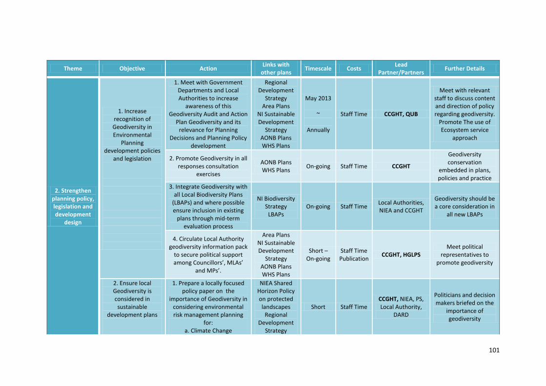
101
Theme Objective Action Links with
other plans Timescale Costs
Lead Partner/Partners
Further Details
2. Strengthen planning policy, legislation and development
design
1. Increase recognition of Geodiversity in Environmental
Planning development policies
and legislation
1. Meet with Government Departments and Local Authorities to increase
awareness of this Geodiversity Audit and Action
Plan Geodiversity and its relevance for Planning
Decisions and Planning Policy development
Regional Development
Strategy Area Plans
NI Sustainable Development
Strategy AONB Plans WHS Plans
May 2013
~
Annually
Staff Time CCGHT, QUB
Meet with relevant staff to discuss content and direction of policy regarding geodiversity.
Promote The use of Ecosystem service
approach
2. Promote Geodiversity in all responses consultation
exercises
AONB Plans WHS Plans
On-going Staff Time CCGHT
Geodiversity conservation
embedded in plans, policies and practice
3. Integrate Geodiversity with all Local Biodiversity Plans
(LBAPs) and where possible ensure inclusion in existing
plans through mid-term evaluation process
NI Biodiversity Strategy
LBAPs On-going Staff Time
Local Authorities, NIEA and CCGHT
Geodiversity should be a core consideration in
all new LBAPs
4. Circulate Local Authority geodiversity information pack
to secure political support among Councillors’, MLAs’
and MPs’.
Area Plans NI Sustainable Development
Strategy AONB Plans WHS Plans
Short – On-going
Staff Time Publication
CCGHT, HGLPS Meet political
representatives to promote geodiversity
2. Ensure local Geodiversity is considered in sustainable
development plans
1. Prepare a locally focused policy paper on the
importance of Geodiversity in considering environmental risk management planning
for: a. Climate Change
NIEA Shared Horizon Policy on protected landscapes
Regional Development
Strategy
Short Staff Time CCGHT, NIEA, PS, Local Authority,
DARD
Politicians and decision makers briefed on the
importance of geodiversity

102
b. Flood Management c. Pollution Control d. Coastal Erosion
and make available to politicians and decision
makers
Area Plans NI Sustainable Development
Strategy AONB Plans WHS Plans
3. Provide support and advice on the
design and restoration of
landscape features (e.g. quarries) that will enhance local
Geodiversity
1. Prepare and circulate a briefing paper and guidance document on best practice for the Geoconservation of
Quarries, new transport corridors and housing
developments in the CCGHT area
AONB Plans WHS Plans ASSI/SAC
Conservation objectives
LBAPs
Short to Medium
Staff Time Publication
Quarries Products Association, CCGHT, GSNI
Guidance document circulated to local
Government, Architects etc. and made available of
CCGHT website

103
Theme Objective Action
Links with other plans
Timescale Costs Lead
Partner/Partners Further Details
3. Collate & maintain a
database of information on
local geodiversity
1. Conduct an Audit and record all Geodiversity in
the CCGHT region including sites, archives, collections and history
1. Continue to record all Geodiversity in the region
AONB Plans
On-going Staff Time
CCGHT
2. Establish a new shared and extended NIEA/GSNI GIS database to present and interpret mapped
and written information
AONB Plans
September 2015
Staff Time
Licenses
GSNI, NIEA, CCGHT
3. Annual review of Quarries Database to identify and document new localities in the region that can
contribute to understanding and interpretation of local and regional
Geodiversity
AONB Plans
Annual Staff Time
CCGHT
4. Audit and record in detail records of earth science collections and archives held by other agencies, universities and museums that
originate from the CCGHT region
AONB Plans
October 2013
Staff Time
CCGHT, Museums Inventories and records in place (linked to 1.1.4)
5. Audit and record all paleontological finds and records
for the region through regular contact with all relevant agencies
and organisations
AONB Plans
Annual Staff Time
CCGHT, Museums, QUB
Inventories and records in place (linked to 1.1.4)
6. Audit and document all building stone used in the construction of properties and buildings using the Northern Ireland Stone Database
AONB Plans
Short to Medium
Staff Time
CCGHT, NIEA
Where necessary visit properties on
the NIEA built heritage list and
record building stone type
7. Catalogue threats likely to impact local Geodiversity
WHS Plans
Medium Staff Time
CCGHT, QUB
8. Audit and record all geodiversity related museum holdings
AONB Plans
Short to Medium
Staff Time
CCGHT

104
Theme Objective Action Links with
other plans Timescale Costs
Lead Partner/Partners
Further Details
4. Conserving & managing
local geodiversity
1. Ensure that sites and features of Earth
Science importance are protected from
adverse impacts of development (Linked
to 2.1)
1. Meet relevant agencies, land owners and businesses to
promote Geoconservation best practice guidelines in
development plans and policies to protect sites currently not under ASSI, WHS or other designated
status
Area Plans AONB Plans WHS Plans
ESCR Conservation
Objectives ASSI/SAC
Conservation objectives
September 2013
~ Annually
Staff Costs
CCGHT, PS, Local Authorities, NIEA
2. Consult on all major planning applications that have the
potential to impact on local geodiversity
AONB Plans WHS Plans
On-going
Staff Time
PS, Local Authorities, CCGHT
CCGHT to register with DoE as a consultee with earth science interest
Respond to all relevant planning applications
3. Consult annually with Forest Service and DARD on all proposed
land management schemes to prevent loss of access to earth
science sites
AONB Plans Annually Staff Time
CCGHT, FS, PS, DARD
Consult annually with Forest Service on
programmed afforestation
Consult annually with
DARD on future programmes
2. Ensure existing designated sites
maintain favourable conservation status
1. Review earth science ASSIs and produce site management
prescriptions where required
AONB Plans WHS Plans
ESCR Conservation
Objectives ASSI/SAC
Conservation objectives
Annually Staff Time
NIEA, CCGHT
Complete site management
prescriptions and Geoconservation
method statements

105
3. Conserve the earth science interest of individual sites and
features which are not protected by current
legislation
1. Record and conserve important geological features in operational
quarries and encourage enhancement and protection of those features where possible
AONB Plans WHS Plans
ESCR Conservation
Objectives ASSI/SAC
Conservation objectives
LBAPs
On-going Staff Time
Quarries Products Association, NIEA,
CCGHT
Visit active quarries annually and record geological features
Provide quarry owners
with annual report detailing
Geoconservation recommendations
2. Review and advise on quarry restoration plans based on EIA
statements AONB Plans On-going
Staff Time
CCGHT, Quarries Products
Association, NIEA,
Review all EIA statements and
landscape restoration plans for existing
quarries.
Propose recommendations for
Geoconservation based on site features and
best practice
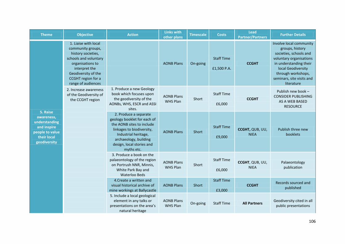
106
Theme Objective Action Links with
other plans Timescale Costs
Lead Partner/Partners
Further Details
5. Raise awareness,
understanding and inspire
people to value their local
geodiversity
1. Liaise with local community groups,
history societies, schools and voluntary
organisations to interpret the
Geodiversity of the CCGHT region for a range of audiences
AONB Plans On-going Staff Time
£1,500 P.A.
CCGHT
Involve local community groups, history
societies, schools and voluntary organisations in understanding their
local Geodiversity through workshops,
seminars, site visits and literature
2. Increase awareness of the Geodiversity of
the CCGHT region
1. Produce a new Geology book which focuses upon
the geodiversity of the AONBs, WHS, ESCR and ASSI
sites.
AONB Plans WHS Plan
Short Staff Time
£6,000
CCGHT
Publish new book – CONSIDER PUBLISHING
AS A WEB BASED RESOURCE
2. Produce a separate geology booklet for each of the AONB sites to include linkages to biodiversity,
Industrial heritage, archaeology, building
design, local stories and myths etc.
AONB Plans Short Staff Time
£9,000
CCGHT, QUB, UU, NIEA
Publish three new booklets
3. Produce a book on the palaeontology of the region
on Portrush NNR, Minnis, White Park Bay and
Waterloo Beds
AONB Plans WHS Plan
Short Staff Time
£6,000
CCGHT, QUB, UU, NIEA
Palaeontology publication
4.Create a written and visual historical archive of
mine workings at Ballycastle AONB Plans Short
Staff Time
£3,000 CCGHT
Records sourced and published
5. Include a local geological element in any talks or
presentations on the area’s natural heritage
AONB Plans WHS Plan
On-going Staff Time All Partners Geodiversity cited in all
public presentations

107
6. Organise a conference / symposium on the
geological history and the influence of geology on local
culture across the three AONBs. The symposium
should show how geology has influenced biodiversity,
landscape, agriculture, settlement, beliefs etc.
AONB Plans WHS Plan
Medium Staff Time
£15,000
CCGHT, QUB, UU, Local Authorities,
NIEA, GSNI
One conference / symposium held with
delegates from UK, Ireland and Europe in
attendance
7. Ensure the WHS and AONB status and wider
geodiversity interest are promoted in pre and post arrival tourism materials
AONB Plans Local Tourism
Plans On-going
Staff Time
Promotional Materials
NITB, Local Authorities,
CCGHT
Geodiversity included in all promotional media
8. Compile a detailed photographic record on all
sites of geological and geomorphological interest
AONB Plans Short Staff Time
£3,000
CCGHT Photographic record
produced
9. Produce a rock and mineral identification guide
for the region. The guide should link with accessible
specimens along the proposed Geodiversity
Heritage Trail (see 5.4.1)
AONB Plans Short £2,500 CCGHT Design and print
mineral guide
10. Produce a new walk series for the CCGHT area
based upon the “Landscapes from Stone” series
AONB Plans GSNI
Objectives
Short to Medium
£10,000 GSNI
3. Incorporate the Arts into linking local
Geodiversity with local culture, myths and
legends
1. Prepare a feasibility study and business case for the
development of a new Geodiversity influenced Sculpture Trail along the Port Path and Causeway
AONB Plans Local Tourism
Plans Council
Access Plans
Short £5,000 CCGHT Complete Feasibility
Study and Business case
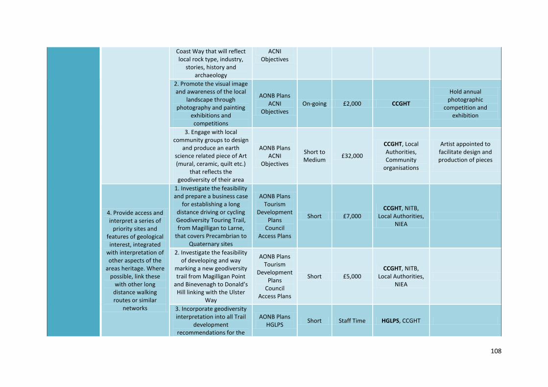
108
Coast Way that will reflect local rock type, industry,
stories, history and archaeology
ACNI Objectives
2. Promote the visual image and awareness of the local
landscape through photography and painting
exhibitions and competitions
AONB Plans ACNI
Objectives On-going £2,000 CCGHT
Hold annual photographic
competition and exhibition
3. Engage with local community groups to design
and produce an earth science related piece of Art (mural, ceramic, quilt etc.)
that reflects the geodiversity of their area
AONB Plans ACNI
Objectives
Short to Medium
£32,000
CCGHT, Local Authorities, Community
organisations
Artist appointed to facilitate design and production of pieces
4. Provide access and interpret a series of
priority sites and features of geological interest, integrated
with interpretation of other aspects of the
areas heritage. Where possible, link these
with other long distance walking routes or similar
networks
1. Investigate the feasibility and prepare a business case
for establishing a long distance driving or cycling Geodiversity Touring Trail, from Magilligan to Larne,
that covers Precambrian to Quaternary sites
AONB Plans Tourism
Development Plans
Council Access Plans
Short £7,000 CCGHT, NITB,
Local Authorities, NIEA
2. Investigate the feasibility of developing and way
marking a new geodiversity trail from Magilligan Point
and Binevenagh to Donald’s Hill linking with the Ulster
Way
AONB Plans Tourism
Development Plans
Council Access Plans
Short £5,000 CCGHT, NITB,
Local Authorities, NIEA
3. Incorporate geodiversity interpretation into all Trail
development recommendations for the
AONB Plans HGLPS
Short Staff Time HGLPS, CCGHT

109
Heart of the Glens Landscape Partnership
programme
Tourism Development
Plans Council
Access Plans
4. Investigate the feasibility of developing the
“Ballycastle Coal Trail” linking this with the
Causeway Coast Way, future Appalachian Trail and the
proposed Marconi’s Cottage to Fairhead Trail
AONB Plans HGLPS
Tourism Development
Plans Council
Access Plans
Short £3,000 HGLPS, CCGHT,
NITB, Local Authorities, NIEA
5. Upgrade access to the disused Coastguard Station on Torr Head and provide
interpretation on the Precambrian – Dalradian
AONB Plans HGLPS
Tourism Development
Plans Council
Access Plans
Short £25,000 HGLPS, CCGHT,
NITB, Local Authorities, NIEA
Route costed and constructed
Interpretation and
literature completed
6. Develop an interpretative “Dolerite Path” at Ramore, Portrush as part of the Port
Path referencing the Neptunist/Vulcanist debate
AONB Plans Tourism
Development Plans
Council Access Plans
Short £10,000 CCGHT, NITB,
Local Authorities, NIEA
Route identified, costed and constructed
Interpretation and
literature completed
7. Map, design and develop the “Red Arch Trail” from Waterfoot to Cushendun
AONB Plans HGLPS
Tourism Development
Plans Council
Access Plans
Short £10,000 HHGLPS, CCGHT,
NITB, Local Authorities, NIEA
Route identified, costed and constructed
Interpretation and
literature completed
8. Map, design and develop an interpretative
AONB Plans HGLPS
Short £15,000 CCGHT, NITB,
Local Authorities, NIEA
Route identified, costed and constructed
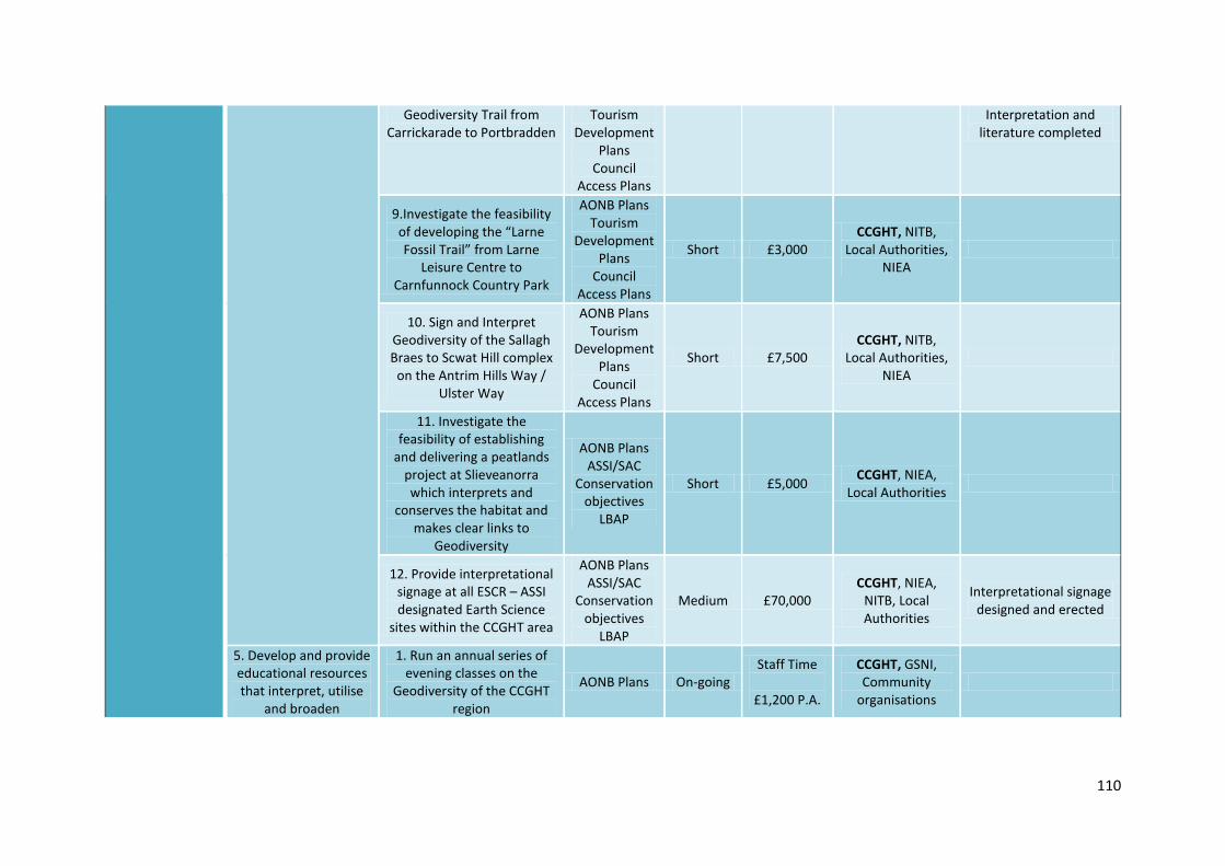
110
Geodiversity Trail from Carrickarade to Portbradden
Tourism Development
Plans Council
Access Plans
Interpretation and literature completed
9.Investigate the feasibility of developing the “Larne Fossil Trail” from Larne
Leisure Centre to Carnfunnock Country Park
AONB Plans Tourism
Development Plans
Council Access Plans
Short £3,000 CCGHT, NITB,
Local Authorities, NIEA
10. Sign and Interpret Geodiversity of the Sallagh Braes to Scwat Hill complex
on the Antrim Hills Way / Ulster Way
AONB Plans Tourism
Development Plans
Council Access Plans
Short £7,500 CCGHT, NITB,
Local Authorities, NIEA
11. Investigate the feasibility of establishing
and delivering a peatlands project at Slieveanorra which interprets and
conserves the habitat and makes clear links to
Geodiversity
AONB Plans ASSI/SAC
Conservation objectives
LBAP
Short £5,000 CCGHT, NIEA,
Local Authorities
12. Provide interpretational signage at all ESCR – ASSI designated Earth Science
sites within the CCGHT area
AONB Plans ASSI/SAC
Conservation objectives
LBAP
Medium £70,000 CCGHT, NIEA,
NITB, Local Authorities
Interpretational signage designed and erected
5. Develop and provide educational resources that interpret, utilise
and broaden
1. Run an annual series of evening classes on the
Geodiversity of the CCGHT region
AONB Plans On-going Staff Time
£1,200 P.A.
CCGHT, GSNI, Community
organisations

111
understanding of the local geodiversity as part of formal and informal learning
2. Develop an accredited geology course for the
CCGHT area and deliver annually through education
and outreach centres
AONB Plans WHS Plans
Short Staff Time
£7,500
CCGHT, GSNI, QUB, Colleges of
FE. OU.
Draft programme and learning objectives and
learning outcomes
Identify accrediting body
Thirty people
completing the course each year
3. Deliver Geodiversity workshops and briefing
sessions to tourism providers to assist with the
provision of information and signposting visitors
AONB Plans Tourism
Development Plans
WHS Plans
On-going Staff Time
CCGHT, Local Authorities,
Tourist Information
Centres
4. Develop site based field work hand and work books for use with Magilligan Field Centre and Bushmills Centre
AONB Plans WHS Plans
LBAP Short
Staff Time
£5,000
CCGHT, GSNI, WELB, NEELB,
Local Authorities
Hand and work books on:
a. Rock classification and identification
b. Rock formation with examples
c. Rocks and Landscape d. Rocks and biodiversity
5. Develop classroom based teaching resource package
on local Earth Science themes
AONB Plans WHS Plans
Short Staff Time
CCGHT, WELB, NEELB
PowerPoint Presentations with supporting teacher
notes and worksheets
6. Establish “Rock Detective” groups through local youth organisations and participating schools
AONB Plans WHS Plans
On-going Staff Time
£1,500
CCGHT, Schools, Youth and
Community Groups
Promote the region as a quality Geotourism
centre
1. Prepare a feasibility study to scope the potential for
AONB Plans WHS Plans
Short £10,000 CCGHT, NITB,
GSNI, Local Authorities, WHS
Report completed highlighting
opportunities,
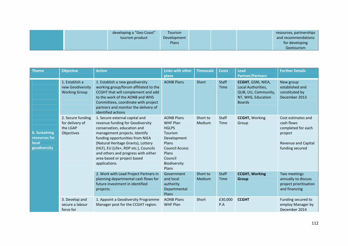
112
developing a “Geo Coast” tourism product
Tourism Development
Plans
resources, partnerships and recommendations
for developing Geotourism
Theme Objective Action Links with other plans
Timescale Costs Lead Partner/Partners
Further Details
6. Sustaining resources for local geodiversity
1. Establish a new Geodiversity Working Group
1. Establish a new geodiversity working group/forum affiliated to the CCGHT that will complement and add to the work of the AONB and WHS Committees, coordinate with project partners and monitor the delivery of identified actions
AONB Plans Short Staff Time
CCGHT, GSNI, NIEA, Local Authorities, QUB, UU, Community, NT, WHS, Education Boards
New group established and constituted by December 2013
2. Secure funding for delivery of the LGAP Objectives
1. Secure external capital and revenue funding for Geodiversity conservation, education and management projects. Identify funding opportunities from NIEA (Natural Heritage Grants), Lottery (HLF), EU (Life+, RDP etc.), Councils and others and progress with either area based or project based applications.
AONB Plans WHF Plan HGLPS Tourism Development Plans Council Access Plans Council Biodiversity Plans
Short to Medium
Staff Time
CCGHT, Working Group
Cost estimates and cash flows completed for each project Revenue and Capital funding secured
2. Work with Lead Project Partners in planning departmental cash flows for future investment in identified projects.
Government and local authority Departmental Plans
Short to Medium
Staff Time
CCGHT, Working Group
Two meetings annually to discuss project prioritisation and financing
3. Develop and secure a labour force for
1. Appoint a Geodiversity Programme Manager post for the CCGHT region.
AONB Plans WHF Plan
Short £30,000 P.A
CCGHT Funding secured to employ Manager by December 2014
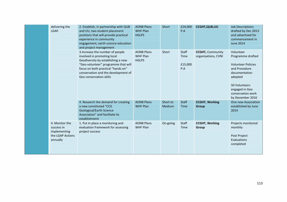
113
delivering the LGAP.
2. Establish, in partnership with QUB and UU, two student placement positions that will provide practical experience in community engagement, earth science education and project management
AONB Plans WHF Plan HGLPS
Short £24,000 P.A
CCGHT,QUB,UU Job Descriptions drafted by Dec 2013 and advertised for commencement in June 2014
3.Increase the number of people involved in promoting local Geodiversity by establishing a new “Geo-volunteer” programme that will focus on both practical “hands on” conservation and the development of Geo conservation skills
AONB Plans WHF Plan HGLPS
Short Staff Time £15,000 P.A
CCGHT, Community organisations, CVNI
Volunteer Programme drafted Volunteer Policies and Procedure documentation adopted 50 Volunteers engaged in Geo conservation work by December 2016
4. Research the demand for creating a new constituted “CCG Geological/Earth Science Association” and facilitate its establishment
AONB Plans WHF Plan
Short to Medium
Staff Time
CCGHT, Working Group
One new Association established by June 2014
4. Monitor the success in implementing the LGAP Actions annually
1. Put in place a monitoring and evaluation framework for assessing project success
AONB Plans WHF Plan
On-going Staff Time
CCGHT, Working Group
Projects monitored monthly Post Project Evaluations completed

114
Theme Objective Action Links with other plans
Timescale Costs Lead Partner/Partners
Further Details
7. Achieving Geopark Status
1. To further the area’s role as a World Heritage Site and secure European Geopark status
1. Act to secure European Geopark Status
WHS Plans AONB Plans
Short Staff Time
CCGHT, GSNI, NIEA, Local Authorities, QUB, UU, Community, NT, WHS, Education Boards
Review through the WHS Steering Group meetings
2. Contribute to the life and work of the European Geopark Network and to regional and national geodiversity fora.
WHS Plans Short CCGHT Develop in association with the WHS Coordinators and others
3. Network with the Atlantic Geosciences Society and prepare a presentation on the WHS and AC & Glens area for the International Geopark meeting
Sept. 2014 CCGHT Also Links to the development of the Appalachian Trail

115
Appendices
Appendix 1: Map illustrating the bedrock geology of the CCGHT area Appendix 2: Map illustrating the location of Dalradian rocks in the CCGHT area Appendix 3: Map illustrating the location of Devonian rocks in the CCGHT area Appendix 4: Map illustrating the location of Carboniferous rocks in the CCGHT area Appendix 5: Map illustrating the location of Triassic rocks in the CCGHT area Appendix 6: Map illustrating the location of Cretaceous rocks in the CCGHT area Appendix 7: Map illustrating the location of Palaeogene rocks in the CCGHT area
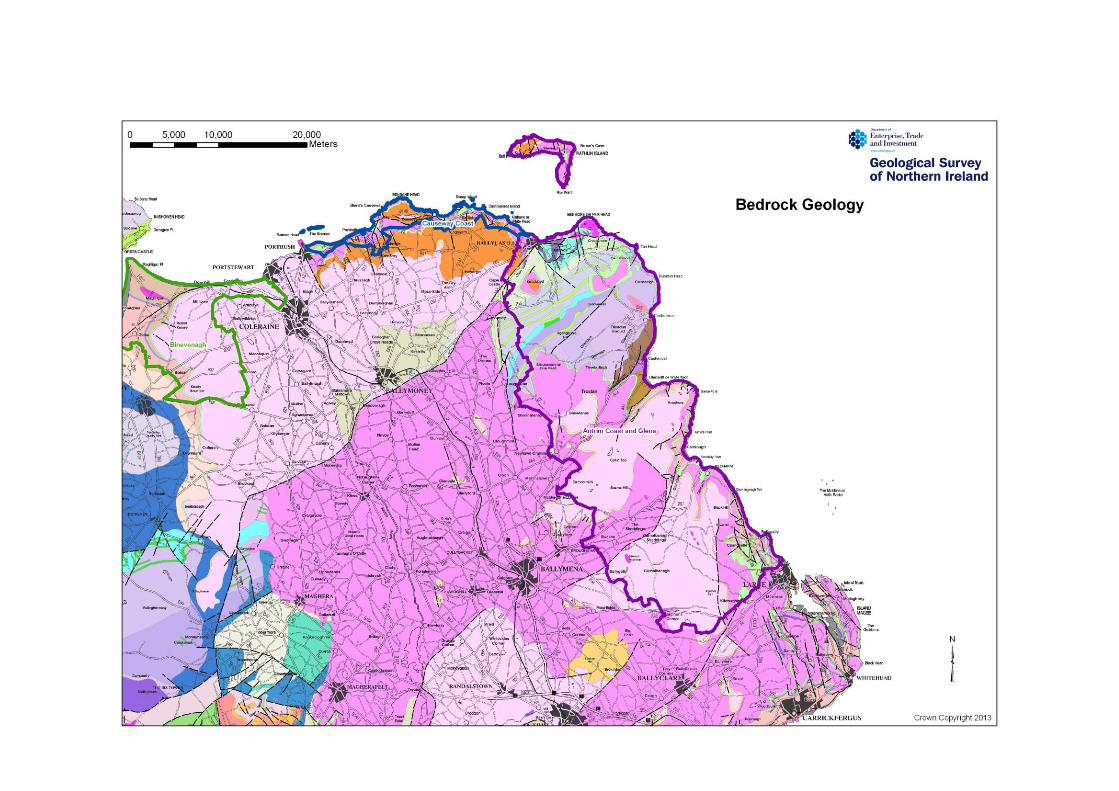
116

117

118
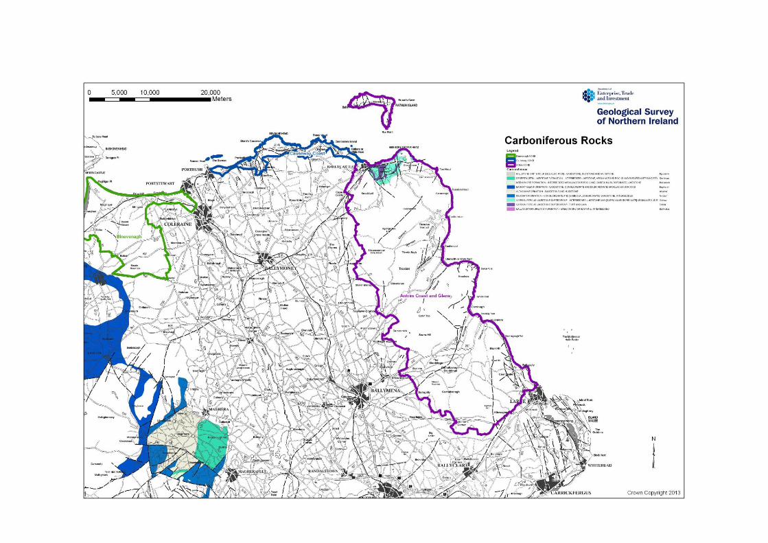
119
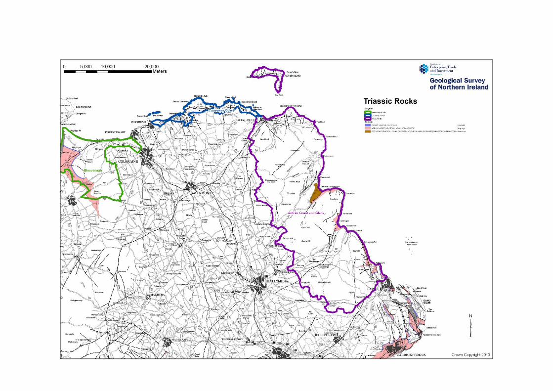
120

121
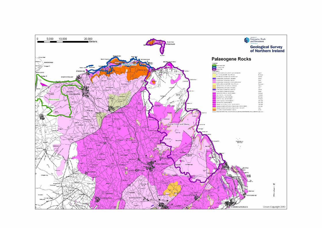
122