
Verification of the 88D Hail Detection Algorithm at WFO Cheyenne Mike Weiland WFO Cheyenne.
Upload
todd-booneCategory
view
15download
0description

An Investigation of Null-Event Severe Convective Watches in the WFO Sterling
Forecast Area
Lee PicardStudent Volunteer, WFO LWX
University of Miami, Coral Gables, FL
Matthew KramarSenior Forecaster, WFO LWX

Definitions
• Severe thunderstorm watcho From SPC: “outlines an area where an organized
episode of hail 1 inch diameter or larger and/or damaging thunderstorm winds are expected during a three to eight hour period.”
• Tornado watcho From SPC: “includes the large hail and damaging wind
threats, as well as the possibility of multiple tornadoes.”

Definitions
• Null watcho A watch, either severe thunderstorm or tornado,
where the expected coverage and intensity of thunderstorms does not materialize

Motivation
• Provide guidance to forecasters as to synoptic patterns that would typically result in a null watch
• Reduce the frequency of null watches and thereby decrease public desensitization

Motivation

Motivation

Motivation

Methodology
• Assembled a database of convective watches issued in the WFO Sterling CWA from 2005-10
• Sorted through archived products to determine if severe weather occurred during watches in CWA
• Eliminated null cases from list subject to:o Outside typical severe season (May-Sept.)o Small part of CWA affectedo Thunderstorms occurred, but below severe threshold

Methodology
• Constructed synoptic composites using data from the NCEP/NCAR and NARR Reanalyses
• Used 6-hour synoptic time immediately preceding watch initiation
Variables:• Geopotential height• Air temperature• Vector wind• Zonal wind• Meridional wind• Relative humidity• Precipitable water
Levels:• 100 mb• 250 mb• 500 mb• 700 mb• 850 mb• 925 mb• Surface

Methodology• Chose 18 cases of very active severe convective
weather watches from 2005-10• Created a second set of composites to use as a
baseline to contrast with null cases
Jan Feb Mar Apr May Jun Jul Aug Sep Oct Nov Dec0
1
2
3
4
5
6
7
8
Number of watches used in composite by month
Null watchesSevere watches

Methodology
• Synoptic compositeso NCEP/NCAR Reanalysis
o Lower resolutiono2.5° x 2.5° lat./lon. grido6-hourly data
o NCEP North American Regional Reanalysis (NARR)oHigher resolutiono1° x 1° lat./lon. grido3-hourly data

500-millibar variablesComparisons
Null events Very active events

500-millibar variables

500-millibar variables

700-millibar variables

850-millibar variables
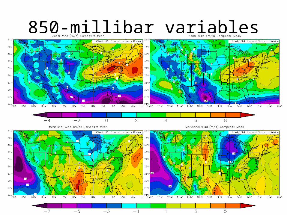
850-millibar variables
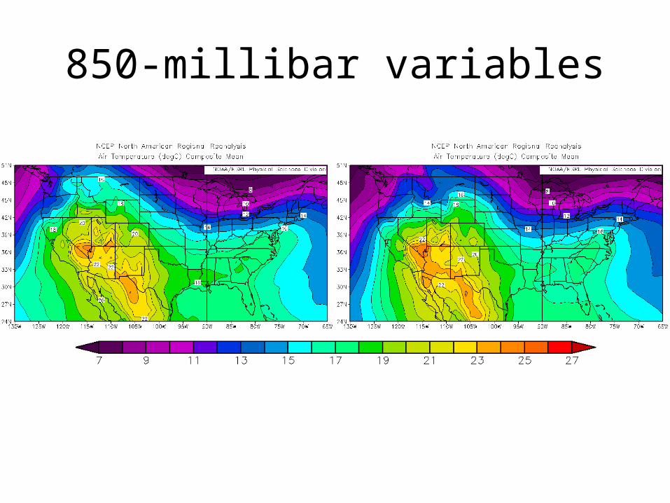
850-millibar variables

925-millibar variables

925-millibar variables

925-millibar variables
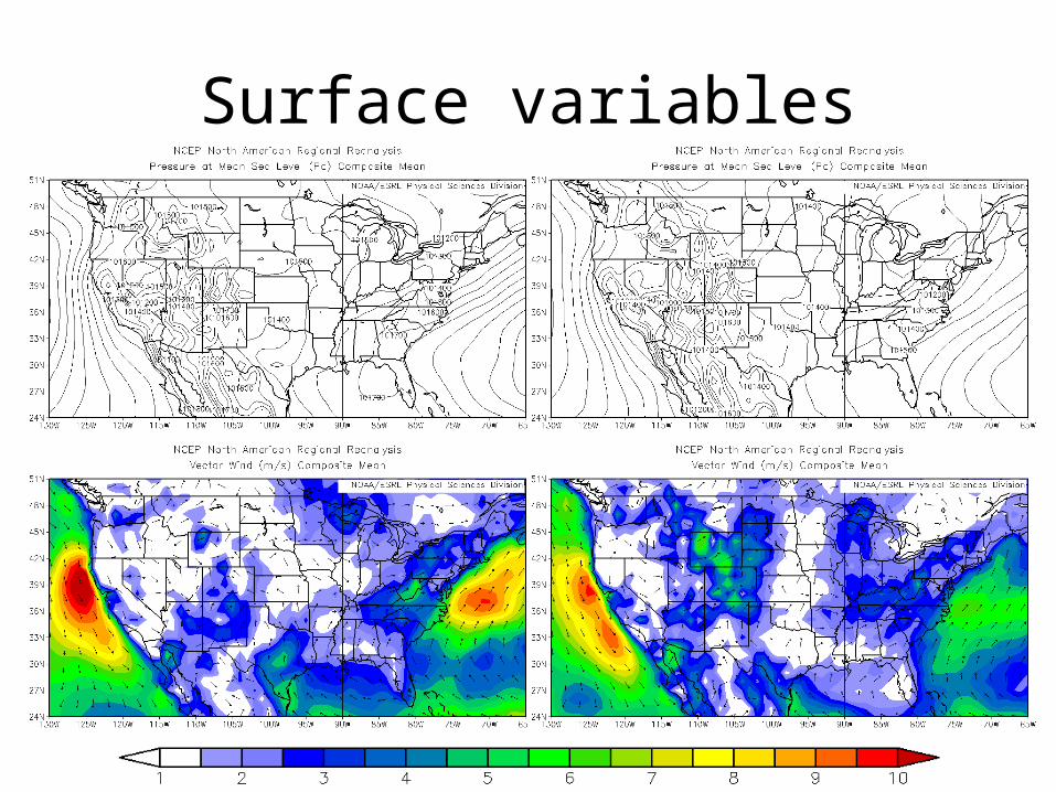
Surface variables
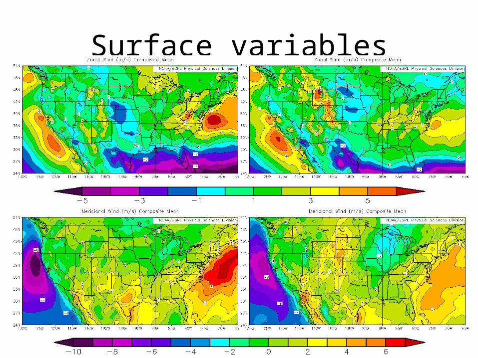
Surface variables

Surface variables

Precipitable Water

Pattern Analogs
• Analog searches provided by Greg Carbin (SPC)o Dates since 1979 with the patterns closest to those of null
watcheso RMS errors for geopotential height at 500 and 850 millibarso Grid difference for precipitable water
• Selected dates that occurred as matches to both the 500- and 850-mb patterns
• Ruled out dates before 1990 and those dissimilar to composite patterns based on manual inspection
• Determined if severe weather occurred on analog dates

Pattern Analogs
• Of 6 national domain matches, three produced severe weather
• Of 6 local domain matches, zero resulted in severe weather– National matches could be tied more heavily to
the ridge/trough patterns across the country and could undervaluate local details that result in null events
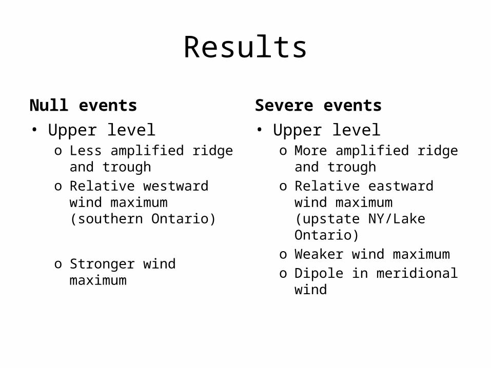
Results
Null events• Upper level
o Less amplified ridge and trough
o Relative westward wind maximum (southern Ontario)
o Stronger wind maximum
Severe events• Upper level
o More amplified ridge and trough
o Relative eastward wind maximum (upstate NY/Lake Ontario)
o Weaker wind maximumo Dipole in meridional wind

Results
Null events• Middle level
o Less amplified ridge and trough
o Less amplified 700-mb temperatures
o Stronger wind maximumo Additional wind maximum
over Atlantic Ocean
Severe events• Middle level
o More amplified ridge and trough
o More amplified 700-mb temperatures
o Weaker wind maximum

Results
Null events• Lower level
o Relative northward surface low pressure center (northern Quebec)
o Strong wind maximum off northeast seaboard
o Relative warmer temperatures
o Relative higher PW
Severe events• Lower level
o Relative southward surface low pressure located (southern Ontario)
o Weak wind maximum off northeast seaboard
o Relative cooler temperatures
o Relative lower PW

Local Domain 500 & 850 mb Geopotential Height Composites