All that Remains: Daggett’s Borate · PDF fileAll that Remains: Daggett’s Borate...
14
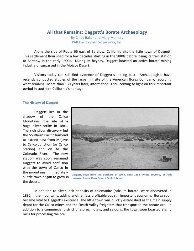
All that Remains: Daggett’s Borate Archaeology By Cindy Baker and Mary Maniery PAR Environmental Services, Inc. Along the side of Route 66 east of Barstow, California sits the little town of Daggett. This settlement flourished for a few decades starting in the 1880s before losing its train station to Barstow in the early 1900s. During its heyday, Daggett boasted an active borate mining industry unsurpassed in the Mojave Desert. Visitors today can still find evidence of Daggett’s mining past. Archaeologists have recently conducted studies of the large mill site of the American Borax Company, recording what remains. More than 130 years later, information is still coming to light on this important period in southern California’s heritage. The History of Daggett Daggett lies in the shadow of the Calico Mountains, the site of a huge silver strike in 1881. The rich silver discovery led the Southern Pacific Railroad to extend east from Mojave to Calico Junction (or Calico Station) and on to the Colorado River. The new station was soon renamed Daggett to avoid confusion with the town of Calico in the mountains. Immediately a little town began to grow in the desert. In addition to silver, rich deposits of colemanite (calcium borate) were discovered in 1882 in the mountains, adding another less profitable but still important economy. Borax soon became vital to Daggett’s existence. The little town was quickly established as the main supply depot for the Calico mines and the Death Valley freighters that transported the borate ore. In addition to a commercial district of stores, hotels, and saloons, the town soon boasted stamp mills for processing the ore. Daggett, seen from the outskirts of town, circa 1884 (Photo courtesy of Arda Haenszel Room, Kern County Public Library).
Transcript of All that Remains: Daggett’s Borate · PDF fileAll that Remains: Daggett’s Borate...
All that Remains: Daggett’s Borate Archaeology
By Cindy Baker and Mary Maniery PAR Environmental Services, Inc.
Along the side of Route 66 east of Barstow, California sits the little town of Daggett. This settlement flourished for a few decades starting in the 1880s before losing its train station to Barstow in the early 1900s. During its heyday, Daggett boasted an active borate mining industry unsurpassed in the Mojave Desert. Visitors today can still find evidence of Daggett’s mining past. Archaeologists have recently conducted studies of the large mill site of the American Borax Company, recording what remains. More than 130 years later, information is still coming to light on this important period in southern California’s heritage. The History of Daggett Daggett lies in the shadow of the Calico Mountains, the site of a huge silver strike in 1881. The rich silver discovery led the Southern Pacific Railroad to extend east from Mojave to Calico Junction (or Calico Station) and on to the Colorado River. The new station was soon renamed Daggett to avoid confusion with the town of Calico in the mountains. Immediately a little town began to grow in the desert. In addition to silver, rich deposits of colemanite (calcium borate) were discovered in 1882 in the mountains, adding another less profitable but still important economy. Borax soon became vital to Daggett’s existence. The little town was quickly established as the main supply depot for the Calico mines and the Death Valley freighters that transported the borate ore. In addition to a commercial district of stores, hotels, and saloons, the town soon boasted stamp mills for processing the ore.
Daggett, seen from the outskirts of town, circa 1884 (Photo courtesy of Arda Haenszel Room, Kern County Public Library).
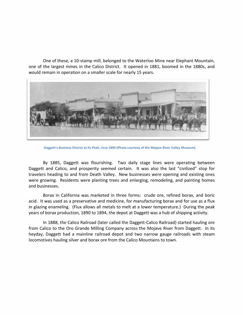
Daggett's Business District at its Peak, circa 1890 (Photo courtesy of the Mojave River Valley Museum).
One of these, a 10-stamp mill, belonged to the Waterloo Mine near Elephant Mountain, one of the largest mines in the Calico District. It opened in 1881, boomed in the 1880s, and would remain in operation on a smaller scale for nearly 15 years.
By 1885, Daggett was flourishing. Two daily stage lines were operating between Daggett and Calico, and prosperity seemed certain. It was also the last “civilized” stop for travelers heading to and from Death Valley. New businesses were opening and existing ones were growing. Residents were planting trees and enlarging, remodeling, and painting homes and businesses.
Borax in California was marketed in three forms: crude ore, refined borax, and boric acid. It was used as a preservative and medicine, for manufacturing borax and for use as a flux in glazing enameling. (Flux allows all metals to melt at a lower temperature.) During the peak years of borax production, 1890 to 1894, the depot at Daggett was a hub of shipping activity.
In 1888, the Calico Railroad (later called the Daggett-Calico Railroad) started hauling ore from Calico to the Oro Grande Milling Company across the Mojave River from Daggett. In its heyday, Daggett had a mainline railroad depot and two narrow gauge railroads with steam locomotives hauling silver and borax ore from the Calico Mountains to town.

The Columbia Mining Company and American Borax Company Mill
The large borax processing mill of the Columbia Mining and Chemical Company was constructed in Daggett in 1894 just south of the Mojave River. The 20-acre mill site had a large crushing building for pulverizing the borate, with large vats and evaporation (settling) ponds.
In 1899, the American Borax Company bought borate mining claims at Lead Mountain and started plans for a railroad to reach the processing plants in Daggett. At that time, the Columbia operation was hauling their raw borax shale from their mine seven miles to the north to process it at their borax works in Daggett. These were operated under the direction of Dr. F. Howard Humphries, who oversaw the company plant with its boiling tanks, a filter press, and evaporating and crystalizing tanks. The ore was ground and heated in water, then drained into settling ponds where the borax would eventually crystalize at the top. Workers would then bag and ship the material to a refinery to finish the product for market. The remains of the ponds are still visible today between the Daggett Ditch and the Mojave River on the west side of the Daggett-Yermo Road.

In 1901, Columbia Mining was purchased by American Borax Works, a subsidiary of the Standard Sanitary Company of Pittsburg, Pennsylvania. They also purchased large mud deposits near Daggett and Columbia’s mill, making the first attempt in the United States to work low-grade deposits of calcium borate ore. American added new machinery to switch from the previous “air” method to a newer “steam” process to manufacture sulphurus acid. This produced boracic acid concentrate, which was used mainly by the company’s operations in Pennsylvania for making refined boric acid. At its peak, the American Borax Works produced 30 tons of pure boric acid each month.
Top: Columbia Borax Mill (before expansion by the American Borax Works). Bottom: Mill after expansion (Photos courtesy of Arda Haenszel Room, Kern County Public Library.)

American Borax added a seven-mile-long narrow gauge railroad to replace the wagon teams hauling the ore to Daggett and bought the locomotive of the Waterloo Mining Company’s railroad as that company ended its operations. By 1902, the surrounding borax mines employed 200 men in the area and Daggett benefited as the shipping point for their products. In that year Daggett boasted three borax mines, three stores, three saloons, two Chinese restaurants, a drug store, a lumber yard, and a hotel. By 1905, the American Borax Works was one of three companies producing the majority of the borax and boric acid in the United States.
Portion of Perris' Miners Map of the Desert Region of Southern California, 1896, depicting railroads, roads and mines around Daggett.
Daggett’s Declining Years
In 1903, the San Pedro, Los Angeles & Salt Lake Railroad (later owned by the Union Pacific Railroad) built their line from Las Vegas through Daggett on its line to Los Angeles and East San Pedro. When the railroad built its round house and maintenance yards at Barstow rather than Daggett, many of the local businesses moved as well A few years later, a large colemanite discovery was made just 30 miles from Los Angeles, prompting American Borax to move its entire operation there, along with the old locomotive and the narrow gauge railroad line. With that move, the borax works at Daggett were abandoned, and the town began a nearly fatal decline. Soon the little town had only one store, one restaurant, one saloon, and a post office. Half the town was abandoned, with houses damaged and some burned, many in a large fire that swept the commercial district in 1908. Daggett began a final and permanent decline when rich borax deposits were found in Death Valley, creating a new center of activity. Daggett Today In 1930, the Barstow-Daggett Airport and Beacon became an important site of air aviation in southern California. By 1955, it was among the top ten busiest stations in the nation, due to its proximity to the Victorville Army Air Base. All this ended in 1961, however, when the airport was relocated. Today Daggett has a population of about 200, with another 1,500 or so living in the surrounding area. Establishment of military bases and solar energy plants has helped the little town, but Daggett’s claim to fame remains those colorful days of more than a century ago. Archaeology in Action at Daggett In 1994 a team of archaeologist surveying west of Daggett stumbled across long rows of small wooden posts sticking up from the sand. They had discovered remnants of the boric acid settling ponds of the American Borax Works, abandoned nearly 90 years earlier. In 2013 archaeologists returned to the site, recording its features and documenting the layout and design of the plant, as seen through the industrial footprint left behind.

Archaeological Site Map for the Columbia (American) Borax Works, drawn in 1994. Maps like this become part of a permanent record kept for the archaeological site that can be reviewed by others in the future.
In documenting sites like this, archaeologists walk in a closely-spaced grid, inspecting every square foot for information. They use pin flags to mark artifacts or activity areas. Careful mapping using a combination of modern technology (like GPS equipment) and old fashioned tools (like compasses and tape measures) helps to identify different activity areas that can be compared with historical aerials and photographs to assist with the identification of each area’s function. Archaeologists mapping the site in 1994 and again in 2013 found ten features of the old American Borax Works site. Features are man-made alterations to a landscape and can include depressions, linear trenches, building foundations, roads, or any other visible change to the

ground surface. At this site, known as CA-SBR-7872H (the official state designation for the archaeological remains at the American Borax Works site), archaeologists mapped and recorded the settling ponds, remnants of the narrow gauge railroad, concrete foundations, bricks, pits, and concrete footings. Studying the placement of these features and their relationship to one another adds another layer of information to the historical accounts of the borax works. Historical photographs indicate that a series of settling or evaporation ponds paralleled the Mojave River to the south. The ponds were long and rectangular in shape. Photos show them framed with boards and held in place by short wooden posts. These are clearly visible in a 1919 photograph of the abandoned ponds. Through the last century many of the boards have deteriorated, but archaeologists recorded what remained of the old upright posts and remnant boards.
Man’s use of the desert leaves scars that take a century or more to heal. Today, the pond outlines made over 100 years ago are plainly evident when viewed with Google Earth. Archaeologist working at the site noted that the surfaces of the former ponds are slightly depressed, and each is lined with tar or pitch residue. Each pond is about 118 feet long and 50 feet wide and the support posts are spaced about 10 feet apart. Some of the ponds have been destroyed or damaged by periodic flooding of the Mojave River, damage that is also clearly evident on aerial photographs.
Surviving Posts of the Borax Evaporation Ponds, Daggett, 2015 Desert archaeology often requires less removal of dirt and debris, as the lack of vegetation, combined with low rainfall, leaves the past easily visible on the ground surface.
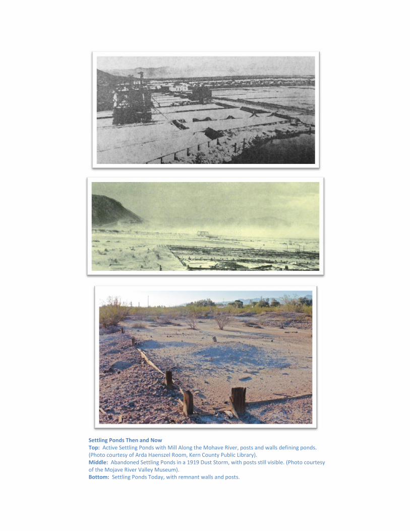
Settling Ponds Then and Now Top: Active Settling Ponds with Mill Along the Mohave River, posts and walls defining ponds. (Photo courtesy of Arda Haenszel Room, Kern County Public Library). Middle: Abandoned Settling Ponds in a 1919 Dust Storm, with posts still visible. (Photo courtesy of the Mojave River Valley Museum). Bottom: Settling Ponds Today, with remnant walls and posts.

While ties and rails that marked the route of the narrow gauge railroad are long gone,
the elevated earthen berm used for a loading ramp remains. This berm is 100 feet long, about 25 feet wide, and 10 feet or more high. Square railroad ties and beams are eroding out of the sand. The center of the berm has been breached or eroded away. Like the ponds, the berm is visible on Google Earth at the edge of the ponds.
Columbia Borax Works- Then and Now. Top: Here the plant was in full operation. The railroad ramp is visible in front of the buildings and the hills behind help place the photographer’s location very near the modern photo below. (Photo courtesy of the Mojave River Valley Museum). Bottom: The loading ramp berm today and the hills are the best monuments left for helping archaeologists determine the former borax works plant layout.
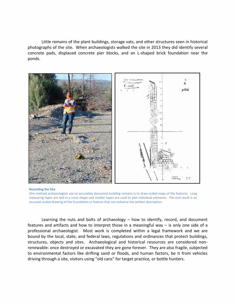
Little remains of the plant buildings, storage vats, and other structures seen in historical photographs of the site. When archaeologists walked the site in 2013 they did identify several concrete pads, displaced concrete pier blocks, and an L-shaped brick foundation near the ponds.
Learning the nuts and bolts of archaeology – how to identify, record, and document features and artifacts and how to interpret those in a meaningful way – is only one side of a professional archaeologist. Most work is completed within a legal framework and we are bound by the local, state, and federal laws, regulations and ordinances that protect buildings, structures, objects and sites. Archaeological and historical resources are considered non-renewable: once destroyed or excavated they are gone forever. They are also fragile, subjected to environmental factors like drifting sand or floods, and human factors, be it from vehicles driving through a site, visitors using “old cans” for target practice, or bottle hunters.
Recording the Site One method archaeologists use to accurately document building remains is to draw scaled maps of the features. Long measuring tapes are laid in a cross shape and smaller tapes are used to plot individual elements. The end result is an accurate scaled drawing of the foundation or feature that can enhance the written description.

The first thing most archaeologists are taught is to respect the sites we study. Even with
surface scatters of trash, the information is valuable when viewed as a whole. We try to lift, document, and replace artifacts where we found them so that the relationship between that one can and all the other cans in the site is not altered. Our underlying goal is to gather as much data as possible on a site with as little disturbance as possible. Archaeological sites on public-managed lands are also protected by law and most of our work is conducted through permits, with strict requirements on treatment of sites, where information is distributed, and how to report our findings. A secondary goal is to involve the public in protecting sites by informing them of the laws that discourage artifact hunting and collecting on public lands (stiff fines and a felony if convicted!) and setting up programs that accepts volunteers working with trained archaeologists to preserve local history and prehistory. Reporting on sites in public venues, like this article, is another way to reach out to local communities interested in understanding and protecting their history and archaeology sites.
The archaeologists working at the Borax Mill site found very few artifacts left at the pond and mill site -- square and round headed nails, bits of bottle glass, metal nuts and bolts, and chunks of concrete are found here and there in the ponds and foundations. Written accounts of the plant suggest that many men were employed and housed in and around Daggett. Cans, bits and pieces of bottles and dishes, and other household debris are scattered on the surface of the desert. These tin cans and fragments of glass have little monetary value, but to an archaeologists reconstructing past behaviors from the garbage left behind, they offer invaluable clues on where people were getting food, what they were eating, changes in diet through time, and whether the home was a worker camp composed of a male population, or if it housed a family with women, children, and family pets. These simple cans thrown out in the desert suggest a diet with a heavy reliance on canned meats and fish (including ham and sardines). Bits of eggshell found in the sand hint at alternatives to the canned foods. A variety of canned fruits and vegetables complemented the canned protein. Coffee, tea, juice, and cocoa came in tins and evaporated or condensed milk was used instead of perishable fresh milk to sweeten or lighten the drinks, add to cereal, and to bake. Catsup, mustard, pickles, mayonnaise, hot sauces, and other condiments were shipped in glass containers that were broken and discarded after use. Baking powder tins and syrup containers hint at biscuits or pancakes for breakfast, and small bits of egg shells suggests another protein source for workers. While personal items are rare, the trash left behind in the desert suggests that workers may have relaxed at the end of the day with a beer or shot of whiskey and a hand-rolled cigarette. Fragments of alcohol bottles, crushed cone-top beer cans, and pocket tobacco tin pieces and snuff containers support this assumption. Analyzing the crushed cans, bottle fragments, and sherds of pottery aid in gaining insight into the effort it took to live and work in the Mojave Desert, and how local workers and residents rose to the challenge.

Daggett Discards While cans and bits of glass strewn across the desert surface may look like garbage to some, to an archaeologist it is gold. We look at these piles of cans to determine if they are from a kitchen, a workshop, a bar or saloon, or a restaurant. The bottle fragments offer clues on preferences for whiskey or beer, catsup or mustard, and help us reconstruct the daily lives of local residents.

Remembering Daggett’s Past for the Future Although Daggett’s heyday passed over a century ago, its borate mining history is still unsurpassed in the Mojave Desert. Thanks to the work of local historians and archaeologists, much of its history is being recorded and preserved for the future. Hopefully, future generations will be able to clearly imagine the hardworking borax years of Daggett’s desert past.
In order to ensure that the physical remains are available for future generations to study and learn from, please remember that artifacts lose their ability to contribute to interpretive studies when removed from their original context or collected from a site. If you stumble across a trash scatter in the desert (or anywhere for that matter), do your part to avoid a felony and protect our heritage by taking as many photographs as you want, writing notes or blogs on your impressions and descriptions of what you see, and leaving the site as you found it when departing the area.