Albert P. Barker, ISB No. 2867 Travis L. Thompson, ISB No ...
151
SOUTH VALLEY GROUND WATER DISTRICT AND GALENA GROUND WATER DISTRICT’S POST TRIAL MEMORANDUM Page 1 of 10 Albert P. Barker, ISB No. 2867 Travis L. Thompson, ISB No. 6168 Michael A. Short, ISB No. 10554 BARKER ROSHOLT & SIMPSON LLP 1010 W. Jefferson St., Ste. 102 PO Box 2139 Boise, ID 83701-2139 Telephone: (208) 336-07000 Facsimile: (208) 344-6034 [email protected] [email protected] [email protected] James R. Laski, ISB No. 5429 Heather E. O’Leary, ISB No. 8693 LAWSON LASKI CLARK, PLLC 675 Sun Valley Road, Suite A Post Office Box 3310 Ketchum, Idaho 83340 Telephone 208.725.0055 Facsimile 208.725.0076 [email protected] [email protected] [email protected] Attorneys for South Valley Ground Water District and Galena Ground Water District BEFORE THE DEPARTMENT OF WATER RESOURCES OF THE STATE OF IDAHO IN THE MATTER OF BASIN 37 ADMINISTRATIVE PROCEEDING Docket No. AA-WRA-2021-001 SOUTH VALLEY GROUND WATER DISTRICT AND GALENA GROUND WATER DISTRICT’S PROPOSED MITIGATION PLAN COMES NOW, the SOUTH VALLEY GROUND WATER DISTRICT and GALENA GROUND WATER DISTRICT (“Ground Water Districts”) by and through their attorneys of record and hereby submit to the Director a proposed Mitigation Plan under IDAPA 37.03.11.043
Transcript of Albert P. Barker, ISB No. 2867 Travis L. Thompson, ISB No ...
SOUTH VALLEY GROUND WATER DISTRICT AND GALENA GROUND WATER DISTRICT’S POST TRIAL MEMORANDUM Page 1 of 10
Albert P. Barker, ISB No. 2867 Travis L. Thompson, ISB No. 6168 Michael A. Short, ISB No. 10554 BARKER ROSHOLT & SIMPSON LLP 1010 W. Jefferson St., Ste. 102 PO Box 2139 Boise, ID 83701-2139 Telephone: (208) 336-07000 Facsimile: (208) 344-6034 [email protected] [email protected] [email protected] James R. Laski, ISB No. 5429 Heather E. O’Leary, ISB No. 8693 LAWSON LASKI CLARK, PLLC 675 Sun Valley Road, Suite A Post Office Box 3310 Ketchum, Idaho 83340 Telephone 208.725.0055 Facsimile 208.725.0076 [email protected] [email protected] [email protected] Attorneys for South Valley Ground Water District and Galena Ground Water District
BEFORE THE DEPARTMENT OF WATER RESOURCES
OF THE STATE OF IDAHO
IN THE MATTER OF BASIN 37 ADMINISTRATIVE PROCEEDING
Docket No. AA-WRA-2021-001 SOUTH VALLEY GROUND WATER DISTRICT AND GALENA GROUND WATER DISTRICT’S PROPOSED MITIGATION PLAN
COMES NOW, the SOUTH VALLEY GROUND WATER DISTRICT and GALENA
GROUND WATER DISTRICT (“Ground Water Districts”) by and through their attorneys of
record and hereby submit to the Director a proposed Mitigation Plan under IDAPA 37.03.11.043
SOUTH VALLEY GROUND WATER DISTRICT AND GALENA GROUND WATER DISTRICT’S POST TRIAL MEMORANDUM Page 2 of 10
in response to the delivery call and demands for conjunctive administration of surface and
ground water use in Silver Creek, the Little Wood and the ground water in the Bellevue Triangle
asserted by certain surface water users.1 These demands for conjunctive administration of
ground water are the subject of the hearing held before the Director, June 7- 12, 2021. This
hearing was triggered by a Notice of Administrative Hearing, AA-WRA-2021-001, issued by the
Director on May 4, 2021. That Notice asserted that, based on the Model, the Director believes
that withdrawal of ground water from wells in the Bellevue Triangle would affect senior surface
water rights on Silver Creek. The Notice also provided that the Director may order ground water
rights in the Bellevue Triangle curtailed for the 2021 irrigation season. Of course affecting
senior surface water right is not sufficient to demonstrate “material injury.” The Notice did not
specify whether the Director would consider any measures other than 100% curtailment of all
ground water use or whether a mitigation plan could be offered. However, when a curtailment
order for ground water pumping was issued in the Rangen delivery call, the order provided that
the ground water users affected by the order could avoid curtailment by participating in an
approved mitigation plan. Rangen Inc. v. IDWR, 160 Idaho 251, 253, 371 P.3d. 305, 307 (2016).
That order advised the ground water users of the amount of water needed, and further provided
that the mitigation plan would be phased in over a five (5) year period. Id at 254, 371 P.3d. at
308; see CM Rule 40.01.a.
Given the urgency the Director has expressed with respect to administration during the
2021 irrigation season, the Ground Water Districts have opted to submit this proposed Mitigation
1 While the Director has characterized this proceeding as administration rather than a delivery call, the CM
Rules make it clear that they are intended to apply to general rules regarding ground water administration in Idaho. IDAPA 37.03.11.001. Indeed, the repeal of portions of the Ground Water Act specifically refers to the use of the CM Rules in lieu of the procedures under the Ground Water Act, or after the effective date of the repeal. See Statement of Purpose HB0043 (2021 Legislative Session).
SOUTH VALLEY GROUND WATER DISTRICT AND GALENA GROUND WATER DISTRICT’S POST TRIAL MEMORANDUM Page 3 of 10
Plan in advance of any Order, contingent on a determination that a curtailment order is necessary
to prevent material injury.
Without waiving their objections to the validity of any potential curtailment order
both a matter of fact and as a matter of legal procedure, the Ground Water Districts
submit this Mitigation Plan to the Director to mitigate and offset any conceivable injury
to specific water rights on Silver Creek or Little Wood River that might have resulted
from continuing to withdraw ground water from the Big Wood Ground Water Aquifer
during the remainder of the 2021 irrigation season.
The testimony and evidence at the hearing established, as a best-case scenario for
the surface water users, that three water rights with April 1883 priorities might receive
water should the 100% curtailment scenario for the Bellevue Triangle ground water rights
outlined in the Notice and Jennifer Sukow’s staff memorandum be ordered. Those three
1883 water rights included Water Right No. 37-344A (4.0 cfs) belonging to Barbara
Farms LLC, which is located below the Milner-Gooding Canal, Water Right No. 37-
344A (4.0 cfs), and Water Right Nos. 37-423 (0.3 cfs) and 37-49 (4.2 cfs) owned or
operated by Don Taber (and on behalf of Jim Ritter) diverted from the Little Wood River
below Station 10.
With respect to mitigation for potential injury to the Barbara Farms water right,
the Ground Water Districts propose to lease 500 acre-feet from the Henry’s Fork
Reservoir District pursuant to an option agreement for the 2021 irrigation season and
deliver that water via the Milner-Gooding Canal to the Barbara Farms headgates.
Barbara Farms only has identified 217.5 acres that require water for the balance of the
irrigation season that may be injured and require water. Barbara Farms previously

SOUTH VALLEY GROUND WATER DISTRICT AND GALENA GROUND WATER DISTRICT’S POST TRIAL MEMORANDUM Page 4 of 10
secured an alternate water supply for 66 acres through a lease of AFRD#2 water from the
City of Shoshone. Based upon information from the Watermaster Kevin Lakey, Barbara
Farms had diverted and used 490 acre-feet through June 14, 2021. Using 4 cfs as the
diversion rate divided by the total acreage of 217.5 acres, and the needed last day of
irrigation as offered by Mr. Brossy at hearing (Barbara Exhibit 1), the following table
shows the required water left to use on the respective acres:
Crop Acres Last Irrigation Cutoff Days AF
Garden Seed Beans 21 8/30 6/25 66 50.6 Edible Pinto Beans 20 8/25 6/25 61 44.5 Purple Barley 11 7/15 6/25 20 8.0 Malt Barley/Alf 49.5 7/15 6/25 20 36.1 Winter wheat/Alf 12 7/15 6/25 20 8.8 Edible Pinto Beans 16 8/25 6/25 61 47.6 Alfalfa Green Chop 71 8/30 6/25 66 230.5 Rye Green Chop/Alf 17 9/15 6/25 82 50.9 Total 405.3
Barbara Ex. 1 (with estimated acre-feet needed). The rental of 500 acre-feet for delivery through AFRD#2’s Milner Gooding Canal will
supply the estimated crop water need set forth above plus cover any conveyance loss through the
canal.
The Ground Water Districts have been advised that the Big Wood Little Wood
Water Users Association (Association) has already leased 1000 acre-feet of surface water
from Mitigation Inc. for delivery to its members via the Milner-Goodling Canal. See
Exhibit A (Water District 01 June 22, 2021 Weekly Report).2 The Ground Water
Districts are not privy to how that water is or will be allocated. Nevertheless, the Ground
2 Water District 01 notes the rental adjustment to AFRD#2’s account for “Yellowstone Earth Science.”
This is the company owned by the seniors’ consultant Eric Miller.
SOUTH VALLEY GROUND WATER DISTRICT AND GALENA GROUND WATER DISTRICT’S POST TRIAL MEMORANDUM Page 5 of 10
Water Districts also propose to reimburse the Association for the cost of renting 500 acre-
feet of water to the extent that the water is actually rented from Mitigation, Inc., as part of
the Ground Water Districts’ proposed Mitigation Plan, in addition to acquisition of 500
acre-feet from Henry’s Lake Reservoir District.
With respect to the Taber & Ritter 1883 rights on the Little Wood below Station
10, the Ground Water Districts propose three transfers, all of which are attached hereto.
Transfer 1, to supply water right 37-49, transfers 168 acres of water rights from
designated lands in the Bellevue Triangle that are not being irrigated to an array of nine
ground water wells and pumps in the vicinity of Picabo. These pumps will then pump
water into Silver Creek for delivery to the 168 acres under Water Right 37-49 property.
The second transfer to supply water to Water Right No. 37-423 proposes to transfer 36
acres of water from lands in the Bellevue Triangle that are not being irrigated to the place
of use of water right 37-423. These rights transferred will also be pumped from an array
of ground water wells and pumps in the vicinity of Picabo into Silver Creek for delivery
to Water Right 37-423. The total water proposed to be diverted under these two transfers
is 6.0 cfs rather than 4.5 cfs to account for an approximate 25% conveyance loss between
Picabo and Station 10. The third transfer proposes to pump an additional 9 cfs for a total
of 15 cfs, when including Transfers 1 and 2, from the same array of wells and pumps in
the vicinity of Picabo into Silver Creek. These pumps will be supplied by water
transferred from lands that are not being irrigated in the Bellevue Triangle during the
2021 irrigation season. This third transfer is intended to provide additional surety for
delivery of Water Rights 37-49 and 37-423 as well as to provide potential water for the
Barbara Farms water right and for other more junior water rights (i.e. junior to April 6,

SOUTH VALLEY GROUND WATER DISTRICT AND GALENA GROUND WATER DISTRICT’S POST TRIAL MEMORANDUM Page 6 of 10
1883) on the Little Wood, even though there is no evidence that these junior water rights
would receive any water from the 100% curtailment scenario for the rest of the 2021
irrigation season.
Transferring the water rights to nine different wells and pumps will provide
flexibility to allow the Ground Water Districts to maximize the water that can be pumped
at any one time based on the pump capacity, water availability and the ability to provide
positive flow benefits to Silver Creek.
This Mitigation plan demonstrates that more than 1,600 acres of land normally
irrigated by ground water in the Bellevue Triangle are not being irrigated in the Bellevue
Triangle during the 2021 irrigation season and will not be irrigated for the duration of the
2021 irrigation season.
The Ground Water Districts further propose that all crop irrigation in the Bellevue
Triangle area of potential curtailment, as described in Jennifer Sukow’s staff memo, will
cease further ground water withdrawals as of August 15, 2021, with the exception of
3500 acres of pasture and 450 acres of potatoes. All fields in the Bellevue Triangle
growing grain and alfalfa will not be irrigated after the August 15 date proposed in this
Mitigation Plan. This non-use will be in addition to the temporary transfers identified
above. These transfers are proposed to continue throughout the 2021 irrigation season or
as long as the Director determines that benefit would accrue during the irrigation season
to the rights that are protected that could benefit from the 100% curtailment scenario.
The Ground Water Districts submit that this proposed Mitigation Plan more than
offsets any hypothetical benefits that might accrue from 100% curtailment of ground
water withdrawals in the Bellevue Triangle. Approval of this Plan by the Director will
SOUTH VALLEY GROUND WATER DISTRICT AND GALENA GROUND WATER DISTRICT’S POST TRIAL MEMORANDUM Page 7 of 10
avoid injury in excess of ten million dollars to the producers in the Bellevue Triangle that
would otherwise result from the proposed 100% curtailment.
Dated this 23rd day of June, 2021.
BARKER ROSHOLT & SIMPSON LLP /s/ Albert P. Barker _______ Albert P. Barker Attorney for South Valley Ground Water District
LAWSON LASKI CLARK, PLLC /s/ Heather E. O’Leary _______ Heather E. O’Leary Attorney for Galena Ground Water District

SOUTH VALLEY GROUND WATER DISTRICT AND GALENA GROUND WATER DISTRICT’S POST TRIAL MEMORANDUM Page 8 of 10
CERTIFICATE OF SERVICE
I HEREBY CERTIFY that on this 23rd day of June, 2021, the foregoing was filed, served, and copied as shown below.
IDAHO DEPARTMENT OF WATER RESOURCES P.O. Box 83720 Boise, ID 83720-0098
U. S. Mail Hand Delivered Overnight Mail E-mail
Gary L. Spackman Director IDAHO DEPARTMENT OF WATER RESOURCES PO Box 83720 Boise, ID 83720-0098
U. S. Mail Hand Delivered Overnight Mail E-mail
Sarah A. Klahn SOMACH SIMMONS & DUNN 2033 11th St., #5 Boulder, CO 80302
U. S. Mail Overnight Mail E-mail
Candice McHugh Chris Bromley MCHUGH BROMLEY, PLLC Attorneys at Law 380 S. 4th St., Ste. 103 Boise, ID 83702
U. S. Mail Overnight Mail E-mail
Heather O’Leary LAWSON LASKI CLARK PLLC PO Box 3310 Ketchum, ID 83340
U. S. Mail Overnight Mail Fax E-mail
Matthew A. Johnson Brian T. O’Bannon WHITE, PETERSON, GIGRAY & NICHOLS, P.A. 5700 East Franklin Road, Suite 200 Nampa, ID 83687-7901
U. S. Mail Overnight Mail E-mail
W. Kent Fletcher FLETCHER LAW OFFICE P.O. Box 248 Burley, ID 83318
U. S. Mail Overnight Mail E-mail
SOUTH VALLEY GROUND WATER DISTRICT AND GALENA GROUND WATER DISTRICT’S POST TRIAL MEMORANDUM Page 9 of 10
Laird B. Stone Stephan, Kvanvig, Stone & Trainor P.O. Box 83 Twin Falls, ID 83303-0083
U. S. Mail Overnight Mail E-mail
Norman M. Semanko PARSONS BEHLE & LATIMER 800 West Main Street, Suite 1300 Boise, ID 83702
U. S. Mail Overnight Mail E-mail
Randall C. Budge Thomas J. Budge RACINE OLSON, PLLP P.O. Box 1391 Pocatello, ID 83204
U. S. Mail Overnight Mail E-mail
Rusty Kramer Water District 37B Groundwater Association P.O. Box 507 Fairfield, ID 83327
U. S. Mail Overnight Mail E-mail
Jerry R. Rigby RIGBY, ANDRUS & RIGBY 25 North Second East Rexburg, ID 83440
U. S. Mail Overnight Mail E-mail
Joseph F. James Brendan L. Ash James Law Office, PLLC 125 5th Ave. West Gooding, ID 83330
U. S. Mail Overnight Mail E-mail
Robert L. Harris HOLDEN, KIDWELL, HAHN & CRAPO PLLC P.O. Box 50130 Idaho Falls, ID 83405
U. S. Mail Overnight Mail E-mail
James P. Speck Speck & Aanestad P.O. Box 987 Ketchum, ID 83340
U. S. Mail Overnight Mail E-mail
Richard T. Roats Lincoln County Prosecuting Attorney P.O. Box 860 Shoshone, ID 83352
U. S. Mail Overnight Mail E-mail

SOUTH VALLEY GROUND WATER DISTRICT AND GALENA GROUND WATER DISTRICT’S POST TRIAL MEMORANDUM Page 10 of 10
Paul Bennett 114 Calypso Lane Bellevue, ID 83313
U. S. Mail Overnight Mail E-mail
J. Evan Robertson Gary D. Slette Robertson & Slette, PLLC P.O. Box 1906 Twin Falls, ID 83303-1906
U. S. Mail Overnight Mail E-mail
Ann Y. Vonde P.O. Box 83720 Boise, ID 83720-0010
U. S. Mail Overnight Mail E-mail
John K. Simpson Barker Rosholt & Simpson LLP P.O. Box 2139 Boise, ID 83701-2139
U. S. Mail Overnight Mail E-mail
Lawrence Schoen Napuisunaih 18351 U.S. Highway 20 Bellevue, ID 83313
U. S. Mail Overnight Mail E-mail
Idaho Ranch Hands Property Management 218 Meadowbrook Hailey, ID 83333
U. S. Mail Overnight Mail E-mail
Southern Comfort Homeowner’s Association P.O. Box 2739 Ketchum, ID 83340
U. S. Mail Hand Delivered Overnight Mail
Michael C. Creamer Michael P. Lawrence Charlie S. Baser Givens Pursley LLP P.O. Box 2720 Boise, ID 83701-2720
U. S. Mail Overnight Mail E-mail
_/s/ Albert P. Barker _______
Albert P. Barker
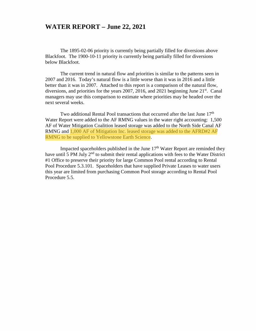
WATER REPORT – June 22, 2021 The 1895-02-06 priority is currently being partially filled for diversions above Blackfoot. The 1900-10-11 priority is currently being partially filled for diversions below Blackfoot. The current trend in natural flow and priorities is similar to the patterns seen in 2007 and 2016. Today’s natural flow is a little worse than it was in 2016 and a little better than it was in 2007. Attached to this report is a comparison of the natural flow, diversions, and priorities for the years 2007, 2016, and 2021 beginning June 21st. Canal managers may use this comparison to estimate where priorities may be headed over the next several weeks. Two additional Rental Pool transactions that occurred after the last June 17th Water Report were added to the AF RMNG values in the water right accounting: 1,500 AF of Water Mitigation Coalition leased storage was added to the North Side Canal AF RMNG and 1,000 AF of Mitigation Inc. leased storage was added to the AFRD#2 AF RMNG to be supplied to Yellowstone Earth Science. Impacted spaceholders published in the June 17th Water Report are reminded they have until 5 PM July 2nd to submit their rental applications with fees to the Water District #1 Office to preserve their priority for large Common Pool rental according to Rental Pool Procedure 5.3.101. Spaceholders that have supplied Private Leases to water users this year are limited from purchasing Common Pool storage according to Rental Pool Procedure 5.5.
albertb
Highlight

TOTAL NATURAL FLOW, TOTAL DIVERSIONS, AND PRIORITY COMPARISON PRELIMINARY ACCOUNTING
2007 IRRIGATION YEAR 2016 IRRIGATION YEAR 2021 IRRIGATION YEAR TOTAL TOTAL TOTAL
NATURAL TOTAL REACH GAIN NATURAL TOTAL REACH GAIN NATURAL TOTAL REACH GAIN
FLOW DIVERSIONS SNAKE RIVER BLACKFOOT FLOW DIVERSIONS SNAKE RIVER BLACKFOOT FLOW DIVERSIONS SNAKE RIVER BLACKFOOT
ABOVE ABOVE AT HEISE TO ABOVE ABOVE AT HEISE TO ABOVE ABOVE AT HEISE TO
MILNER HEISE BLACKFOOT BLACKFOOT PRIORITY MILNER BLACKFOOT BLACKFOOT PRIORITY MILNER BLACKFOOT BLACKFOOT PRIORITY MILNER
DATE DATE CFS CFS YR-MO-DAY CFS CFS CFS YR-MO-DAY CFS CFS CFS YR-MO-DAY CFS
21.Jun 17-Jun 12952 15858 1895-03-22 3432 17888 16363 1905-10-07 1654 16061 16276 1903-03-26 1543
22.Jun 18-Jun 13126 15872 1895-11-05 3478 16896 15865 1903-03-26 1731 15502 * 16546 • 1900-10-11 *
23.Jun 19-Jun 12440 16286 1895-02-06 3386 16549 15939 1902-03-26 1577 14425 • 16675 * 1900-10-11 *
24.Jun 20.Jun 11667 16398 1885-01-09 3217 16174 16433 1903-03-26 1520 13807 • 16542 * 1900-06-16 *
25.Jun 21.Jun 10646 16434 1892-04-28 2992 15441 16833 1900-10-11 1555 13045 * 16372 * 1896-07-09 *
26.Jun 22.Jun 10229 16481 1891-12-14 3064 14997 17120 1900-10-11 1502 11863 * 16186 * 1895-02-06 *
27.Jun 23.Jun 9909 16564 1891-12-14 3203 14521 17347 1900-10-11 1556
28.Jun 24-Jun 9615 16461 1891-01-24 3128 14022 17305 1900-10-11 1539 • Projected Data
29-Jun 25-Jun 9408 16365 1891-01-24 2847 13408 17089 1898-04-15 1609
30.Jun 26-Jun 9084 16384 1891-01-24 2515 12752 16882 1895-06-01 1778
1-Jul 27-Jun 8927 16233 1890-10-16 2075 12061 16879 1895-02-06 1571
2-Jul 28-Jun 8320 16411 1890-06-01 2084 11104 17128 1894-08-18 1498
3-Jul 29-Jun 8319 16685 1890-06-01 2103 10845 17530 1892-06-01 1449
4-Jul 30-Jun 8358 16667 1890-06-10 1996 10924 17551 1892-06-01 1550
5-Jul 1-Jul 8193 16499 1890-06-01 1901 14059 17387 1894-08-18 1647
6-Jul 2-Jul 8146 16350 1890-06-10 1918 11164 16914 1895-01-09 1587
7-Jul 3-Jul 7812 16279 1890-09-26 1890 10847 16269 1895-01-09 1430
8-Jul 4-Jul 7724 16086 1890-07-10 1758 10305 16292 1892-06-01 1349
9-Jul 5-Jul 7505 15997 1890-07-10 1599 10087 16307 1892-04-28 1327
10.Jul 6-Jul 7192 15928 1889-06-01 1621 9839 16423 1891-06-01 1237
11-Jul 7-Jul 7141 15841 1889-06-01 1847 9477 16265 1891-01-24 1398
12-Jul 8-Jul 7084 15741 1889-06-01 1718 9286 16131 1891-01-24 1345
13-Jul 9-Jul 7101 15669 1889-06-01 1633 8951 15956 1891-01-24 1658
14-Jul 10.Jul 7252 15074 1889-07-10 1657 8992 15607 1891-01-24 1799
15.Jul 11-Jul 6750 14323 1889-05-11 1570 9490 14928 1892-04-28 1790
16.Jul 12-Jul 6261 14207 1889-05-11 1459 9768 14673 1893-04-30 1749
17.Jul 13-Jul 6172 14337 1889-05-11 1548 9578 14322 1892-06-01 1547
18.Jul 14-Jul 6122 13786 1889-05-11 1525 8604 13898 1891-01-24 1609
19.Jul 15-Jul 6256 13720 1889-05-11 1516 8066 13281 1890-10-16 1658
20.Jul 16-Jul 6145 13526 1889-05-11 1547 7768 13142 1890-07-12 1726
21.Jul 17.Jul 6495 13221 1889-05-11 1603 7627 13030 1890-07-12 1767
22.Jul 18.Jul 6470 12790 1889-05-11 1549 7583 13041 1890-06-10 1987
23.Jul 19.Jul 6328 12461 1889-05-11 1576 8291 13050 1890-10-16 1377
24.Jul 20.Jul 6063 12227 1889-05-11 1681 7017 13035 1889-06-01 1457
25.Jul 21-Jul 5795 11913 1889-05-01 1884 7249 13287 1889-07-10 1549
26.Jul 22-Jul 5656 11619 1889-04-15 1823 7140 13222 1889-06-01 1631
27-Jul 23.Jul 5541 11691 1889-04-16 1906 7006 13084 1889-07-10 1976
28-Jul 24.Jul 5727 11537 1889-05-11 1983 6894 13048 1889-07-10 1945
29.Jul 25-Jul 6211 11564 1889-05-11 2027 6585 12996 1889-06-01 1923
30.Jul 26-Jul 6697 11475 1889-06-01 2137 6489 12876 1889-06-01 1969
31-Jul 27-Jul 7562 11138 1891-12-14 2184 6561 12850 1889-06-01 1907
1-Aug 28.Jul 7342 10985 1891-01-24 2237 6519 12904 1889-05-20 1840
2-Aug 29.Jul 6865 10765 1890-07-12 2320 6430 12923 1889-05-11 1819
3-Aug 30.Jul 6415 10354 1890-07-10 2380 6388 12881 1889-05-11 1758
4-Aug 31.Jul 5910 10368 1889-05-11 2176 6433 12631 1889-06-01 1656
5-Aug 1-Aug 5559 10437 1889-05-01 2213 6246 12305 1889-06-01 1697
6-Aug 2-Aug 5640 10421 1889-05-11 2037 6177 12205 1889-04-15 1578
7-Aug 3-Aug 5832 10472 1889-05-11 1972 6311 12109 1889-05-11 1391
8-Aug 4-Aug 6128 10467 1889-06-01 1985 5888 12056 1889-04-15 1232
9-Aug 5-Aug 5939 10399 1889-05-11 2051 6010 12025 1889-05-11 1166
10-Aug 6-Aug 5849 10135 1889-05-11 2131 5961 11920 1889-04-15 1245

WATER DISTRICT 01 WEEKLY WATER REPORT 06/22/2021 DIVERSION DATA PRIORITY DATES
Projected Priority Dates For Actual Date 06/23/2021 Reach Name
SNAKE ABV LORENZO HENRYS FORK FALLS RIVER TETON RIVER
2/6/1895 2/6/1895 2/6/1895 2/6/1895 2/6/1895 2/6/1895
TETON LOWER N. FORK SNAKE ABV BLCKFOOT SNAKE BLW BLCKFOOT
3/26/1903 3/26/1903 3/26/1903 3/26/1903 3/26/1903 3/26/1903 3/26/1903 10/11/1900
Actual Date
Jun 17 Jun 17 Jun 17 Jun 17 Jun 17 Jun 17 Jun 17 Jun 17 Jun 17 Jun 17 Jun 17 Jun 17 Jun 17 Jun 17 Jun 17 Jun 17 Jun 17 Jun 17 Jun 17 Jun 17 Jun 17 Jun 17 Jun 17 Jun 17 Jun 17 Jun 17 Jun 17 Jun 17 Jun 17 Jun 17 Jun 17 Jun 17 Jun 17 Jun 16 Jun 16 Jun 16 Jun 16 Jun 16 Jun 16 Jun 16 Jun 16 Jun 16 Jun 16 Jun 16 Jun 16 Jun 16 Jun 16 Jun 16 Jun 16 Jun 16 Jun 16 Jun 16 Jun 16 Jun 16 Jun 16 Jun 16 Jun 16
Site 13033010 13037505 13037975 13037980 13037985 13038025 13038030 13038055 13038085 13038090 13038098 13038110 13038115 13038145 13038150 13038180 13038204 13038205 13038210 13038225 13038305 13038315 13038340 13038360 13038362 13038388 13038392 13038426 13038431 13038434 13038435 13038436 13038437 13046310 13047305 13047475 13047575 13047681 13048475 13048560 13048705 13049010 13049015 13049550 13049560 13049561 13049705 13049710 13049725 13049805 13050525 13050530 13050535 13050545 13054515 13055030 13055040
Diversion Data
Diversion PALISADES CANAL ANDERSON CANAL (lA) EAGLE ROCK CAN (1) (lB) FARMERS FRIEND ENTERPRISE CANAL BUTLER ISLAND ROSS AND RAND HARRISON CANAL RUDY CANAL LOWDER SLOUGH CANAL KITE & NORD CANAL BURGESS CANAL* (4A) CLARK & EDWARDS* (SA) CROFT DITCH EAST LABELLE CANAL RIGBY CANAL DILTS LATERAL (3) (68) DILTS CANAL (6A) ISLAND CANAL (30A) W. LABELLE & L.I. * (7A) PARKS & LEWISVILLE NORTH RIGBY CANAL WHITE DITCH (4) (7B) BRAMWELL CANAL (8A) ELLIS CANAL (5) (308) MATTSON-CRAIG CANAL SUNNYDELL CANAL (29A) LENROOT CANAL REID CANAL TEXAS & LIBERTY BANNOCK JIM SLOUGH HILL PETTINGER NELSON COREY CANAL DEWEY CANAL YELLOWSTONE CANAL MARYSVILLE CANAL* (9A) FARMERS OWN CANAL (llA) CONANT CK CANAL (12A) ENTERPRISE CANAL FALL RIVER CANAL (16A) CHESTER CANAL SILKEY CANAL CURR CANAL LAST CHANCE CANAL CROSSCUT TO TETN XCUT FALL R (6) (168) FARMERS FRIEND TwIN GROVES CANAL ST ANTHY UNION (17A) SALEM UNION CANAL EGIN CANAL ST ANTHY UNION (7) (178) INDEPENDENT CANAL CONSOLIDATED FRMRS CANYON CREEK CANAL WILFORD CANAL TETON IRRIGATION (18A)
FOOTNOTES: (#) STORAGE DIVERSION COMBINED WITH (#A)
CFS DIVN
77 508 616 467 186
45 4
595 286
52 9
957 70 0
129 205
9 26
195 528 379 so 0 0 0
13 156 105 149 204 14
8 0
22 26
170 34 22
114 136
63 19 27 53 0
216 72 77
374 237 255
66 150 240
0 87 41
TOTAL DIVERSION AND STORAGE USE DOES NOT INCLUDE ADDITIONAL PUMP DIVERSIONS (NOT SHOWN) ADDED AT THE END OF THE YEAR
CFS STOR
0 283
0 133
0 0 0
124 147
0 1
155 0 0 9
44 0 7 0 0
30 0 0 0 0 0 0 0 1 0 0 5 0 0 0 0 0 2
114 0 0 0 0 0 0 0 0 0 0 0 0 0 0 0 0 0 0
AF USED
4 8779
0 3228 815 115
6 1925 3336
51 75
3951 0
41 67
1098 0
40 0
789 1201
301 0 0 0
84 688 786
1229 0
58 224
0 42 0 0 0
15 1161 1101
539 102
0 1547
0 0
21 272
10258 533
2622 0
2359 1528
0 0
985
AF RMNG
-4 42339
0 6118
19390 128
-6 41932
5032 1395
-75 41629
777 -41 710
4936 0
1591 4398 4176 4144
875 0 0 0
386 6086
10229 5700 4568
-58 -224
0 274 464
8199 3193
939 19077
3073 187 -15
22 9910
0 0
2176 2109 7761
24059 8056
814 26143 19268
0 1103
191
6/22/2021

WATER DISTRICT 01 WEEKLY WATER REPORT 06/22/2021 Actual CFS CFS
Date Site Diversion DIVN STOR Jun 16 13055050 PIONEER CANAL 11 Jun 16 13055060 STEWART CANAL 6 Jun 16 13055205 PINCOCK-BYINGTON 0 Jun 16 13055210 TETON ISLND FEEDER 361 Jun 16 13055245 SALEM UNION B 3 Jun 16 13055275 ROXANA CANAL 9 Jun 16 13055280 ISLAND WARD CANAL 10 Jun 16 13055295 SAUREY CANAL 15 Jun 16 13055315 WOODMANSEE-JOHNSON (19A) 8 Jun 16 13055323 CITY OF REXBURG 8 Jun 16 13055334 REXBURG IRRIGATION 147 Jun 17 13057025 BUTTE & MARKET* (20A) 420 Jun 17 13057030 BEAR TRAP CANAL 52 Jun 17 13057125 OSGOOD CANAL 96 Jun 17 13057126 CLEMENTS CANAL 0 Jun 17 13057130 KENNEDY CANAL 11 Jun 17 13057135 GREAT WESTERN (21A) 340 Jun 17 13057145 IDAHO CANAL (33A) 790 Jun 17 13057250 PORTER CANAL (9) (21B) 347 Jun 17 13058125 FERGUSON CANAL 9 Jun 17 13058290 ORVAL AVERY CNL s Jun 17 13058310 ROY AVERY CANAL 13 Jun 17 13058370 R COOPER SAND CR 14 Jun 17 13058380 R COOPER WLLW CK 1 Jun 17 13058510 PROGRESSIVE SAND 628 Jun 17 13058514 W & 0 COOPER 10 Jun 17 13058515 IDAHO FR SAND CK 0 Jun 17 13058530 PROGRESSIVE WILL 162 Jun 17 13059505 WOODVILLE CANAL (22A) 53 Jun 17 13059520 WOODVILLE SIPHON (22D) 13 Jun 17 13059525 SNAKE RIVER VLLY * (23A) 491 Jun 18 13060500 RESERVATION CANAL 182 Jun 18 13060501 X RESERVATION 260 Jun 18 13061430 BLACKFOOT CANAL 367 Jun 18 13061520 NEW LAVA SIDE* (24A) 120 Jun 18 13061525 PEOPLES CANAL* (25A) 331 Jun 18 13061610 ABERDEEN CANAL 1443 Jun 18 13061650 CORBETT CANAL 199 Jun 18 13061670 NIELSON-HANSEN 16 Jun 18 13061705 RIVERSIDE CANAL * (26A) 107 Jun 18 13061995 DANSKIN CANAL 177 Jun 18 13062050 TREGO CANAL 45 Jun 18 13062051 JENSEN GROVE 23 Jun 18 13062503 WEARYRICK CANAL 49 Jun 18 13062506 WATSON CANAL 84 Jun 18 13062507 PARSONS CANAL 35 Jun 19 13075900 FT HALL MICHAUD 150 Jun 19 13076400 FALLS IRRIG PUMP 144 Jun 20 13080000 MINIDOKA NSIOE * (27A) 1360 Jun 20 13080500 MINIDOKA SSIDE (10) (27B) 1229 Jun 21 13085500 A & B IRRIGATION 308 Jun 21 13085800 PA LATRL PUMP (11) (28B) 54 Jun 21 13086000 MILNER IRRIGATION 296 Jun 21 13086520 NSIDE XCT GONG (11) (28E) 718 Jun 21 13086530 RES DIST #2 CANAL 1697 Jun 21 13087000 N SIDE TWIN FALLS (28A) 3078 Jun 21 13087500 TWIN FALLS S SIDE 3667
FOOTNOTES: (#) STORAGE DIVERSION COMBINED WITH (#A) TOTAL DIVERSION AND STORAGE USE DOES NOT INCLUDE ADDITIONAL PUMP DIVERSIONS (NOT SHOWN) ADDED AT THE END OF THE YEAR
0 0 0 0 0 0 0 0 0 0 0
67 0 0 0 0
44 0 0 0 0 0 0 0 0 0 0 0 0 0 0 0 0 0 0 0
271 0 4 3 0 0 0 0 0 2
150 144
2316 0
308 0
261 0
1697 3449 667
AF AF USED RMNG
0 59 0 11
47 66 2535 4027
3 -3 18 438 85 1565 17 45 0 568 0 0
87 2155 638 48169
so -50 127 10998
0 259 0 194
281 77964 1171 72646
0 0 0 0 0 0 0 0 0 0 0 0 4 -4 0 0 0 0 0 0 0 14243 0 0
1000 70278 0 0 0 0
1596 20731 0 11420
7263 59036 20057 165660
162 9543 417 -417
60 1153 871 2214 230 3293 149 -149 166 267 122 1717 294 573
15697 87384 8954 45303
57615 240073 0 225253
24328 108585 0 0
20364 63785 0 0
140025 248467 155193 681836
26465 206365
6/22/2021


1
STATE OF IDAHODEPARTMENT OF WATER RESOURCES
TEMPORARY CHANGE APPLICATION(To change point of diversion, place of use, or purpose of use of a water right upondeclaration of a drought emergency in accordance with Section 42-222A, Idaho Code.)
Name of Applicant Phone
Mailing Address Email
A. PURPOSE OF TRANSFER1. Change point of diversion Add diversion point(s) Change place of use
Change purpose of use Other
2. Describe the proposed change(s) and explain the reason(s) they are needed.
B. DESCRIPTION OF RIGHT(S) OR PORTION THEREOF, AFTER THE REQUESTED CHANGE1. Right Number Priority Amount Nature of Use Period of Use (cfs/ac-ft)
to
to
to
to
2. Total amount of water being transferred cubic feet per second and/or acre-feet per annum.
3. Source of water tributary to .
4. Point(s) of diversion:
Twp Rge Sec GovtLot ¼ ¼ ¼ County Source Local name or
tag number
5. Lands irrigated or place of use:
Twp Rge Sec NE ¼ NW ¼ SW ¼ SE ¼ Acre
TotalsNE NW SW SE NE NW SW SE NE NW SW SE NE NW SW SE
Total Acres
South Valley &/or Galena Ground Water Districts 208-336-0700
PO Box 2139, Boise, ID 83701 [email protected]
Ground water rights not in use in 2021 are proposed to be used for mitigation by pumping from select wells into
Silver Creek to augment the discharge of the Little Wood River to benefit an 1883 priority water right identified by
the Watermaster as 37-49.
37-22777 12/5/1979 3.18 Irrigation 4/15 10/31
37-23090 11/13/1959 7.16 Irrigation 4/1 11/01
37-23091 8/1/1960 3.61 Irrigation 4/15 10/31
37-23092 8/20/1964 8.89 Irrigation 4/1 11/1
5.50
Ground Water
1S 20E 20 NW NE NE Blaine Ground Water No Log - RF = 0.1035NE SW " " No Log - RF = 0.147
SE SW SE " "30 NW SW NE " "

1
STATE OF IDAHODEPARTMENT OF WATER RESOURCES
TEMPORARY CHANGE APPLICATION(To change point of diversion, place of use, or purpose of use of a water right upondeclaration of a drought emergency in accordance with Section 42-222A, Idaho Code.)
Name of Applicant Phone
Mailing Address Email
A. PURPOSE OF TRANSFER1. Change point of diversion Add diversion point(s) Change place of use
Change purpose of use Other
2. Describe the proposed change(s) and explain the reason(s) they are needed.
B. DESCRIPTION OF RIGHT(S) OR PORTION THEREOF, AFTER THE REQUESTED CHANGE1. Right Number Priority Amount Nature of Use Period of Use
(cfs/ac-ft)
to
to
to
to
2. Total amount of water being transferred cubic feet per second and/or acre-feet per annum.
3. Source of water tributary to .
4. Point(s) of diversion:
Twp Rge Sec GovtLot ¼ ¼ ¼ County Source Local name or
tag number
5. Lands irrigated or place of use:
Twp Rge Sec NE ¼ NW ¼ SW ¼ SE ¼ Acre
TotalsNE NW SW SE NE NW SW SE NE NW SW SE NE NW SW SE
Total Acres
For additional Water Rights and PODs only.
1S 20E 30 NE NW Blaine Ground Water19E 2 SW NW SW Blaine Ground Water
SE NW SW Blaine Ground Water5 1 SE NE Blaine Ground Water
37-23093 4/1/1984 2.65 Irrigation 4/15 10/31
□ □
□ □
□

1
STATE OF IDAHODEPARTMENT OF WATER RESOURCES
TEMPORARY CHANGE APPLICATION(To change point of diversion, place of use, or purpose of use of a water right upondeclaration of a drought emergency in accordance with Section 42-222A, Idaho Code.)
Name of Applicant Phone
Mailing Address Email
A. PURPOSE OF TRANSFER1. Change point of diversion Add diversion point(s) Change place of use
Change purpose of use Other
2. Describe the proposed change(s) and explain the reason(s) they are needed.
B. DESCRIPTION OF RIGHT(S) OR PORTION THEREOF, AFTER THE REQUESTED CHANGE1. Right Number Priority Amount Nature of Use Period of Use (cfs/ac-ft)
to
to
to
to
2. Total amount of water being transferred cubic feet per second and/or acre-feet per annum.
3. Source of water tributary to .
4. Point(s) of diversion:
Twp Rge Sec GovtLot ¼ ¼ ¼ County Source Local name or
tag number
5. Lands irrigated or place of use:
Twp Rge Sec NE ¼ NW ¼ SW ¼ SE ¼ Acre
TotalsNE NW SW SE NE NW SW SE NE NW SW SE NE NW SW SE
Total Acres
For additional PODs Only
1S 19E 28 SE NW Blaine Ground Water
□ □
□ □
□

2
6. General Information:
a. Who owns the water right to be changed?
b. Describe the arrangement allowing use of the right.
c. Describe the affect on the land now irrigated if the change is approved pursuant to this application:
d. Has the water right sought to be transferred been used this year? Yes No If yes, explain.
e. Absent the changes, how would the right be used for the remainder of the year?
f. Describe other water rights used for the same purpose.
g. Remarks:
I hereby assume all risk in accordance with Section 42-222A, Idaho Code, and assert that no one will be injured by such change and that the change does not constitute an enlargement in use of the original right. The information contained in this application is true to the best of my knowledge. I understand that any willful misrepresentations made in this application may result in voiding its approval.
Signature of Applicant Date
FOR DEPARTMENT USE ONLY
Received by Date $50 fee receipted by Receipt No.
Recommend: approve deny Watermaster recommendation
ACTION OF THE DIRECTOR, DEPARTMENT OF WATER RESOURCES
This is to certify that I have examined Temporary Change Application No. , and said
application is hereby , subject to the following limitations and conditions:
Temporary Change Expiriation Date
Signed this day of , .
For the Director
Aubry Springs Ranch LLC & Blackburn Farming LLCSharing agreement with South Valley and Galena Ground
Water Districts
Water rights are not being used in 2021 & there will be no impact to the lands these rights are appurtenant to.
Remain unused.
None except those identified in this application.
This transfer seeks to augment the discharge of Silver Creek and the Little Wood River to supply waterto water right 37-49.
□ □
Memorandum in Support of Temporary Transfer to Supplement Water Right N0. 37-49
The remaining 122.9 acres from water right 37-22777, copy attached, are fallowed and the water from this right is proposed to be transferred to the place of us of water right 37-49, copy attached, for the current year. The remaining 45.1 acres to cover the 168 acres currently being irrigated under water right 37-49 will be transferred from water rights 37-23090, 37-23091, 37-23092 and 37-23093 as described further below.
Water from 45.1 acres not being irrigated this year will be provided from portions of water rights 37-23090, 37-23091, 37-23092 and 37-23093 not currently being used. The place of use for these 4 water rights has been reshaped this year with over 200 acres fallowed and not being irrigated that are within the place of use of these 4 water rights. The lands have been identified through the overlay of a sketch map, copy attached, with the current place of use of the water rights. A more precise mapping can be prepared of the idle acres if needed as time permits. Copies of the water rights are attached.
Up to 5.5 cfs of ground water will be diverted from wells shown on the Temporary Change Application this Memorandum is accompanying. The RF shown on the Application, for the wells without a well log, is the response function taken from the support files accompanying Jennifer Sukow’s May 17, 2021 Memorandum titled “Predicted hydrologic response in Silver Creek and the Little Wood River to curtailment of groundwater use in 2021, Basin 37 Administrative Proceeding, AA-WRA-2021-001.” The response function is the fraction of the diverted water estimated to appear in Silver Creek by the end of September 2021.

Department of
WATER RIGHT REPORT
5/25/2021
IDAHO DEPARTMENT OF WATER RESOURCES
Water Right Report
WATER RIGHT NO. 37-49
Owner Type Name and AddressCurrent Owner JAMES B RITTERCurrent Owner LINDA RITTER
PO BOX 28RICHFIELD, ID 833492088862163
Priority Date: 04/01/1883
Basis: Decreed
Status: Active
Source TributaryLITTLE WOOD RIVER MALAD RIVER
Beneficial Use From To Diversion Rate VolumeIRRIGATION 03/15 11/15 4.2 CFSTotal Diversion 4.2 CFS
Location of Point(s) of Diversion:
LITTLE WOOD RIVER SENENW Sec. 23 Township 05S Range 18E LINCOLN CountyLITTLE WOOD RIVER NWSENW Sec. 23 Township 05S Range 18E LINCOLN CountyLITTLE WOOD RIVER SENENW Sec. 27 Township 05S Range 18E LINCOLN CountyLITTLE WOOD RIVER SESWSE Sec. 28 Township 05S Range 18E LINCOLN CountyPlace(s) of use:
Place of Use Legal Description: IRRIGATION LINCOLN County
Township Range Section Lot Tract Acres Lot Tract Acres Lot Tract Acres Lot Tract Acres05S 18E 27 NWNE 19.9
NENW 28.2 NWNW 1.3 SWNW 25.9 SENW 25.9NWSW 28.8 SWSW 6.1
28 SENE 22.2NESE 26.3 SWSE 13.6 SESE 17.5
Total Acres: 215.7
Conditions of Approval:
1. Right limited to 4.07 cfs when diverted from pump in Little Wood River.2. R05 Use of water under this right will be regulated by a watermaster with responsibility for the distribution of water among
appropriators within a water district. At the time of this approval, this water right is within State Water District No. 37M.3. R43 The right holder shall maintain a measuring device and lockable controlling works of a type approved by the Department
in a manner that will provide the watermaster suitable control of the diversions.4. U42 Place of use does not include federal public lands.5. T07 The right holder shall accomplish the change authorized by this transfer within one year of the date of this approval.6. T08 Failure of the right holder to comply with the conditions of this transfer is cause for the Director to rescind approval of
the transfer.7. T19 Pursuant to Section 42-1412(6), Idaho Code, this water right is subject to such general provisions necessary for the
definition of the rights or for the efficient administration of water rights as may be determined by the Snake River BasinAdjudication court at a point in time no later than the entry of the final unified decree.
IDWR offices are open to the public and following the CDC guidelines for wearing masks and observing social
distancing. For in-person visits, we encourage you to call ahead for an appointment.
Home / Water Rights / Research / Search Water Rights
Water Right Report https://idwr.idaho.gov/apps/ExtSearch/RightReportAJ.asp?BasinNumber=37&Seque...
1 of 2 5/25/2021, 1:31 PM
JDAJ--{Owater Resources ~
X

Dates:
Licensed Date:
Decreed Date: 09/29/2006
Enlargement Use Priority Date:
Enlargement Statute Priority Date:
Water Supply Bank Enrollment Date Accepted:
Water Supply Bank Enrollment Date Removed:
Application Received Date:
Protest Deadline Date:
Number of Protests: 0
Other Information:
State or Federal: S
Owner Name Connector: And
Water District Number: 37
Generic Max Rate per Acre:
Generic Max Volume per Acre:
Civil Case Number:
Old Case Number:
Decree Plantiff:
Decree Defendant:
Swan Falls Trust or Nontrust: T
Swan Falls Dismissed:
DLE Act Number:
Cary Act Number:
Mitigation Plan: False
Water Right Report https://idwr.idaho.gov/apps/ExtSearch/RightReportAJ.asp?BasinNumber=37&Seque...
2 of 2 5/25/2021, 1:31 PM
Department of
WATER RIGHT REPORT
6/17/2021
IDAHO DEPARTMENT OF WATER RESOURCES
Water Right Report
WATER RIGHT NO. 37-22777
Owner Type Name and AddressCurrent Owner AUBREY SPRING RANCH LLC
18450 HWY 20BELLEVUE, ID 833136506449516
Original Owner KENNETH F HELLYERPriority Date: 12/05/1979
Basis: License
Status: Active
Source TributaryGROUND WATER
Beneficial Use From To Diversion Rate VolumeIRRIGATION 04/15 10/31 3.18 CFS 556.2 AFATotal Diversion 3.18 CFS 556.2 AFA
Location of Point(s) of Diversion:
GROUND WATER Injection SWSW Sec. 13 Township 01S Range 19E BLAINE CountyGROUND WATER SENE Sec. 14 Township 01S Range 19E BLAINE CountyGROUND WATER Rediversion NWNW Sec. 24 Township 01S Range 19E BLAINE CountyPlace(s) of use:
Place of Use Legal Description: IRRIGATION BLAINE County
Township Range Section Lot Tract Acres Lot Tract Acres Lot Tract Acres Lot Tract Acres01S 19E 13 SWNW 10
NESW 10 NWSW 36 SWSW 30 SESW 1.614 SENE 3.2
SESE 3.123 NENE 36 SENE 29
Total Acres: 158.9
Conditions of Approval:
1. 004 The issuance of this right does not grant any right-of-way or easement across the land of another.2. R05 Use of water under this right will be regulated by a watermaster with responsibility for the distribution of water among
appropriators within a water district. At the time of this approval, this water right is within State Water District No.37M.
3. R43 The right holder shall maintain a measuring device and lockable controlling works of a type approved by theDepartment in a manner that will provide the watermaster suitable control of the diversion(s).
4. X11 The right holder shall install and maintain acceptable measuring devices at the point of injection into Loving Creek andat the point of rediversion from Loving Creek.
5. X35 Rights 37-22777, 37-2553A and 37-8571 when combined shall not exceed a total diversion rate of 5.46 cfs.6. R55 This right is for the use of trust water and is subject to review 20 years after the issuance of the permit to determine
availability of water and to re-evaluate the public interest.7. R63 This right when combined with all other rights shall provide no more than 0.02 cfs per acre nor more than 3.5 afa per
acre at the field headgate for irrigation of the place of use.
IDWR offices are open to the public and following the CDC guidelines for wearing masks and observing social
distancing. For in-person visits, we encourage you to call ahead for an appointment.
Home / Water Rights / Research / Search Water Rights
Water Right Report https://idwr.idaho.gov/apps/ExtSearch/RightReportAJ.asp?BasinNumber=37&Seque...
1 of 2 6/17/2021, 2:09 PM
JDAJ--{Owater Resources ~
X

8. 065 The right holder shall make full beneficial use of all surface water rights available to the right holder for irrigation ofthe lands authorized to be irrigated under this right. The right holder shall limit the diversion of ground water underthis right to those times when the surface water supply is not available or the surface water supply is not reasonablysufficient to irrigate the place of use authorized under this right.
9. 105 If the surface water right(s) appurtenant to the place of use is abandoned, forfeited, sold, transferred, leased or usedon any other place of use, this right to divert ground water shall not be used for irrigation purposes without anapproved transfer pursuant to Section 42-222, Idaho Code, or approval of the Department if a transfer is not required.
10. An intake screen acceptable to Idaho Fish & Game shall be installed at the point of rediversion on Loving Creek toprevent any negative impact on juvenile fish.
Dates:
Licensed Date: 01/14/2013
Decreed Date:
Enlargement Use Priority Date:
Enlargement Statute Priority Date:
Water Supply Bank Enrollment Date Accepted:
Water Supply Bank Enrollment Date Removed:
Application Received Date:
Protest Deadline Date:
Number of Protests: 0
Other Information:
State or Federal:
Owner Name Connector:
Water District Number: 37
Generic Max Rate per Acre:
Generic Max Volume per Acre:
Combined Acres Limit:
Combined Volume Limit:
Combined Rate Limit: 5.46
Civil Case Number:
Old Case Number:
Decree Plantiff:
Decree Defendant:
Swan Falls Trust or Nontrust: T
Swan Falls Dismissed:
DLE Act Number:
Cary Act Number:
Mitigation Plan: False
Water Right Report https://idwr.idaho.gov/apps/ExtSearch/RightReportAJ.asp?BasinNumber=37&Seque...
2 of 2 6/17/2021, 2:09 PM

!.
!.
!. 1314
2423
18
19
The USDA-FSA Aerial Photography Field office asks to becredited in derived products.
State of IdahoDepartment of Water Resources
Water Right37-22777
Map produced on June 21, 2021
IRRIGATION
19E 20E
19E 20E
01S
01
S 01S
01S
!. Point of Diversion
Place Of Use Boundary
Townships
PLS Sections
Quarter Quarters ´
0 0.4 0.80.2 Miles
The map depicts the place of use for the water use listed above and point(s) of diversion of this right as currentlyderived from interpretations of the paper records and is used solely for illustrative purposes. Discrepancies between the computer representation and the permanent document file will be resolved in favor of the actual water right documentsin the water right file.
D D D D
I I I I I I I I I

Department of
WATER RIGHT REPORT
6/18/2021
IDAHO DEPARTMENT OF WATER RESOURCES
Water Right Report
WATER RIGHT NO. 37-23090
Owner Type Name and AddressCurrent Owner BLACKBURN FARMING LLC
535 GANNETT RD UNIT EBELLEVUE, ID 83313-50452084810348
Trustee MICHAEL LOVAS13233 SNOWSHOE THOMPSON CIRTRUCKEE, CA 961619255770293
Original Owner NMS LEASING INCBANK OF HAWAIIATTN: MS KIM YOSHIMOTO130 MERCHANT STHONOLULU, HI 968028085384737
Original Owner K F HELLYERHWY 68GANNETT, ID 83329
Security Interest LOVAS TRUST13233 SNOWSHOE THOMPSON CIRTRUCKEE, CA 96161-51819255770293
Priority Date: 11/13/1959
Basis: Decreed
Status: Active
Source TributaryGROUND WATER
Beneficial Use From To Diversion Rate VolumeIRRIGATION 04/01 11/01 7.16 CFS 1256.8 AFATotal Diversion 7.16 CFS 1256.8 AFA
Location of Point(s) of Diversion:
GROUND WATER NWSWNW Sec. 17 Township 01N Range 19E BLAINE CountyGROUND WATER NENENW Sec. 20 Township 01N Range 19E BLAINE CountyGROUND WATER SWSENW Sec. 28 Township 01N Range 19E BLAINE CountyIRRIGATION Use:
Acre Limit: 359.1
Place(s) of use:
Place of Use Legal Description: IRRIGATION BLAINE County
Township Range Section Lot Tract Acres Lot Tract Acres Lot Tract Acres Lot Tract Acres01N 19E 17 SWNE 38
SWNW 31 SENW 40NESW 40 NWSW 13 SESW 26
IDWR offices are open to the public and following the CDC guidelines for wearing masks and observing social
distancing. For in-person visits, we encourage you to call ahead for an appointment.
Home / Water Rights / Research / Search Water Rights
Water Right Report https://idwr.idaho.gov/apps/ExtSearch/RightReportAJ.asp?BasinNumber=37&Seque...
1 of 3 6/18/2021, 2:38 PM
JDAJ--{Owater Resources ~
X
NESE 11 NWSE 40 SWSE 40 SESE 2220 NENE 39 NWNE 38.5 SWNE 19 SENE 40
NENW 7NESE 35 NWSE 1.3 SESE 13
21 8 NWNW 10 9 SWNW 911 NWSW 24 SWSW 36 12 SESW 1.2
27 NENE 11 NWNE 9 SWNE 40 SENE 11SWNW 13 SENW 30NESW 40 NWSW 38 SWSW 40 SESW 30NESE 3.8 NWSE 36 SWSE 4
28 SWNE 14 SENE 4NENW 13 NWNW 29 SWNW 6.4 SENW 37NESW 22 SESW 2.2NESE 39 NWSE 39 SWSE 36 SESE 40
33 NENE 40 NWNE 14 SENE 3034 NENW 0.2 NWNW 31 SWNW 15
Total Acres: 1291.6
Conditions of Approval:
1. Total combined delivery at the field headgates (for surface water rights) and diversion at the wellheads (for groundwater rights) for this right along with water right nos. 37-23083, 37-23084, 37-23085, 37-23086, 37-23087, 37-23088,37-23089, 37-23090, 37-23091, 37-23092 and 37-23093 shall not exceed a total instantaneous rate of 25.8 cfs (whichequates to 0.02 cfs per acre over the combined permissible places of use for these water rights totaling 1291.6 acres).
2. Total volume of water delivered to the field from this right along with water right nos. 37-481B, 37-482G, 37-483B,37-665K, 37-666J, 37-667N, 37-2625A, 37-2638, 37-2700, 37-21463, and 37-22155 shall not exceed 4626.9 acre-feet peryear (which equates to 3.5 acre-feet per acre over the combined permissible places of use for these water rightstotaling 1291.6 acres).
3. C05 Right includes accomplished change in place of use pursuant to Section 42-1425, Idaho Code.4. Right Nos. 37-23090, 37-23091, 37-23092 and 37-23093 are limited to the irrigation of a combined total of 1291.6 acres
in a single irrigation season.5. E52 The rights listed below are limited to a total combined diversion rate of 19.65 cfs. Combined Right Nos.: 37-23090,
37-23091, 37-23092 and 37-23093.6. C18 This partial decree is subject to such general provisions necessary for the definition of the rights or for the efficient
administration of the water rights as may be ultimately determined by the Court at a point in time no later than theentry of a final unified decree. Section 42-1412(6), Idaho Code.
7. 104 If the surface water rights appurtenant to the place of use is sold, transferred, leased or used on any other place ofuse, this right to divert ground water shall not be used without an approved transfer pursuant to Section 42-222, IdahoCode, or approval of the Department if a transfer is not required.
8. C03 Right includes accomplished change in point of diversion pursuant to Section 42-1425, Idaho Code.9. K06 This right is limited to the irrigation of 359.1 acres within the place of use described above in a single irrigation season.10. K01 Right No. 37-23093 is an enlargement of this right pursuant to Section 42-1426, Idaho Code.11. Right Nos. 37-23083, 37-23084, 37-23085, 37-23086, 37-23087, 37-23088, 37-23089, 37-23090, 37-23091, 37-23092 and
37-23093 are limited to the irrigation of a combined total of 1291.6 acres in a single irrigation season.12. 065 The right holder shall make full beneficial use of all surface water rights available to the right holder for irrigation of
the lands authorized to be irrigated under this right. The right holder shall limit the diversion of ground water underthis right to those times when the surface water supply is not available or the surface water supply is not reasonablysufficient to irrigate the place of use authorized under this right.
Dates:
Licensed Date:
Decreed Date: 01/14/2009
Enlargement Use Priority Date:
Enlargement Statute Priority Date:
Water Supply Bank Enrollment Date Accepted:
Water Supply Bank Enrollment Date Removed:
Application Received Date:
Protest Deadline Date:
Number of Protests: 0
Other Information:
State or Federal: S
Owner Name Connector:
Water District Number: 37
Generic Max Rate per Acre:
Generic Max Volume per Acre:
Combined Acres Limit: 1291.6
Combined Volume Limit: 19.7
Combined Rate Limit:
Civil Case Number:
Water Right Report https://idwr.idaho.gov/apps/ExtSearch/RightReportAJ.asp?BasinNumber=37&Seque...
2 of 3 6/18/2021, 2:38 PM

Old Case Number:
Decree Plantiff:
Decree Defendant:
Swan Falls Trust or Nontrust:
Swan Falls Dismissed:
DLE Act Number:
Cary Act Number:
Mitigation Plan: False
Water Right Report https://idwr.idaho.gov/apps/ExtSearch/RightReportAJ.asp?BasinNumber=37&Seque...
3 of 3 6/18/2021, 2:38 PM

Department of
WATER RIGHT REPORT
6/18/2021
IDAHO DEPARTMENT OF WATER RESOURCES
Water Right Report
WATER RIGHT NO. 37-23091
Owner Type Name and AddressCurrent Owner BLACKBURN FARMING LLC
535 GANNETT RD UNIT EBELLEVUE, ID 83313-50452084810348
Trustee MICHAEL LOVAS13233 SNOWSHOE THOMPSON CIRTRUCKEE, CA 961619255770293
Original Owner NMS LEASING INCBANK OF HAWAIIATTN: MS KIM YOSHIMOTO130 MERCHANT STHONOLULU, HI 968028085384737
Original Owner K F HELLYERHWY 68GANNETT, ID 83329
Security Interest LOVAS TRUST13233 SNOWSHOE THOMPSON CIRTRUCKEE, CA 96161-51819255770293
Priority Date: 08/01/1960
Basis: Decreed
Status: Active
Source TributaryGROUND WATER
Beneficial Use From To Diversion Rate VolumeIRRIGATION 04/15 10/31 3.61 CFS 1455.2 AFATotal Diversion 3.61 CFS 1455.2 AFA
Location of Point(s) of Diversion:
GROUND WATER NWSWNW Sec. 17 Township 01N Range 19E BLAINE CountyGROUND WATER NENENW Sec. 20 Township 01N Range 19E BLAINE CountyGROUND WATER SWSENW Sec. 28 Township 01N Range 19E BLAINE CountyIRRIGATION Use:
Acre Limit: 385.2
Place(s) of use:
Place of Use Legal Description: IRRIGATION BLAINE County
Township Range Section Lot Tract Acres Lot Tract Acres Lot Tract Acres Lot Tract Acres01N 19E 17 SWNE 38
SWNW 31 SENW 40NESW 40 NWSW 13 SESW 26
IDWR offices are open to the public and following the CDC guidelines for wearing masks and observing social
distancing. For in-person visits, we encourage you to call ahead for an appointment.
Home / Water Rights / Research / Search Water Rights
Water Right Report https://idwr.idaho.gov/apps/ExtSearch/RightReportAJ.asp?BasinNumber=37&Seque...
1 of 3 6/18/2021, 2:42 PM
JDAJ--{Owater Resources ~
X

NESE 11 NWSE 40 SWSE 40 SESE 2220 NENE 39 NWNE 38.5 SWNE 19 SENE 40
NENW 7NESE 35 NWSE 1.3 SESE 13
21 8 NWNW 10 9 SWNW 911 NWSW 24 SWSW 36 12 SESW 1.2
27 NENE 11 NWNE 9 SWNE 40 SENE 11SWNW 13 SENW 30NESW 40 NWSW 38 SWSW 40 SESW 30NESE 3.8 NWSE 36 SWSE 4
28 SWNE 14 SENE 4NENW 13 NWNW 29 SWNW 6.4 SENW 37NESW 22 SESW 2.2NESE 39 NWSE 39 SWSE 36 SESE 40
33 NENE 40 NWNE 14 SENE 3034 NENW 0.2 NWNW 31 SWNW 15
Total Acres: 1291.6
Conditions of Approval:
1. C03 Right includes accomplished change in point of diversion pursuant to Section 42-1425, Idaho Code.2. E55 Right Nos. 37-23091 and 37-23092 are limited to the irrigation of a combined total of 757.9 acres in a single irrigation
season.3. Total volume of water delivered to the field from this right along with water right nos. 37-23083, 37-23084, 37-23085,
37-23086, 37-23087, 37-23088, 37-23089, 37-23090, 37-23091, 37-23092 and 37-23093 shall not exceed 4626.9 acre-feetper year (which equates to 3.5 acre-feet per acre over the combined permissible places of use for these water rightstotaling 1291.6 acres).
4. 104 If the surface water rights appurtenant to the place of use is sold, transferred, leased or used on any other place ofuse, this right to divert ground water shall not be used without an approved transfer pursuant to Section 42-222, IdahoCode, or approval of the Department if a transfer is not required.
5. X27 This right is limited to the irrigation of 385.2 acres within the place of use described above in a single irrigation season.6. E52 The rights listed below are limited to a total combined diversion rate of 19.65 cfs. Combined Right Nos.: 37-23090,
37-23091, 37-23092 and 37-23093.7. Right Nos. 37-23090, 37-23091, 37-23092 and 37-23093 are limited to the irrigation of a combined total of 1291.6 acres
in a single irrigation season.8. Right Nos. 37-23083, 37-23084, 37-23085, 37-23086, 37-23087, 37-23088, 37-23089, 37-23090, 37-23091, 37-23092 and
37-23093 are limited to the irrigation of a combined total of 1291.6 acres in a single irrigation season.9. C05 Right includes accomplished change in place of use pursuant to Section 42-1425, Idaho Code.10. Total combined delivery at the field headgates (for surface water rights) and diversion at the wellheads (for ground
water rights) for this right along with water right nos. 37-23083, 37-23084, 37-23085, 37-23086, 37-23087, 37-23088,37-23089, 37-23090, 37-23091, 37-23092 and 37-23093 shall not exceed a total instantaneous rate of 25.8 cfs (whichequates to 0.02 cfs per acre over the combined permissible places of use for these water rights totaling 1291.6 acres).
11. C18 This partial decree is subject to such general provisions necessary for the definition of the rights or for the efficientadministration of the water rights as may be ultimately determined by the Court at a point in time no later than theentry of a final unified decree. Section 42-1412(6), Idaho Code.
12. 065 The right holder shall make full beneficial use of all surface water rights available to the right holder for irrigation ofthe lands authorized to be irrigated under this right. The right holder shall limit the diversion of ground water underthis right to those times when the surface water supply is not available or the surface water supply is not reasonablysufficient to irrigate the place of use authorized under this right.
Dates:
Licensed Date:
Decreed Date: 01/14/2009
Enlargement Use Priority Date:
Enlargement Statute Priority Date:
Water Supply Bank Enrollment Date Accepted:
Water Supply Bank Enrollment Date Removed:
Application Received Date:
Protest Deadline Date:
Number of Protests: 0
Other Information:
State or Federal: S
Owner Name Connector:
Water District Number: 37
Generic Max Rate per Acre:
Generic Max Volume per Acre:
Combined Acres Limit: 1291.6
Combined Volume Limit: 19.7
Combined Rate Limit:
Water Right Report https://idwr.idaho.gov/apps/ExtSearch/RightReportAJ.asp?BasinNumber=37&Seque...
2 of 3 6/18/2021, 2:42 PM

Civil Case Number:
Old Case Number:
Decree Plantiff:
Decree Defendant:
Swan Falls Trust or Nontrust:
Swan Falls Dismissed:
DLE Act Number:
Cary Act Number:
Mitigation Plan: False
Water Right Report https://idwr.idaho.gov/apps/ExtSearch/RightReportAJ.asp?BasinNumber=37&Seque...
3 of 3 6/18/2021, 2:42 PM
Department of
WATER RIGHT REPORT
6/18/2021
IDAHO DEPARTMENT OF WATER RESOURCES
Water Right Report
WATER RIGHT NO. 37-23092
Owner Type Name and AddressCurrent Owner BLACKBURN FARMING LLC
535 GANNETT RD UNIT EBELLEVUE, ID 83313-50452084810348
Trustee MICHAEL LOVAS13233 SNOWSHOE THOMPSON CIRTRUCKEE, CA 961619255770293
Original Owner NMS LEASING INCOriginal Owner K F HELLYER
BANK OF HAWAIIATTN: MS KIM YOSHIMOTO130 MERCHANT STHONOLULU, HI 968028085384737
Original Owner FRED BROSSYCOVE RANCHBELLEVUE, ID 83313
Security Interest LOVAS TRUST13233 SNOWSHOE THOMPSON CIRTRUCKEE, CA 96161-51819255770293
Priority Date: 08/20/1964
Basis: Decreed
Status: Active
Source TributaryGROUND WATER
Beneficial Use From To Diversion Rate VolumeIRRIGATION 04/01 11/01 8.89 CFS 1333.8 AFATotal Diversion 8.89 CFS 1333.8 AFA
Location of Point(s) of Diversion:
GROUND WATER NWSWNW Sec. 17 Township 01N Range 19E BLAINE CountyGROUND WATER NENENW Sec. 20 Township 01N Range 19E BLAINE CountyGROUND WATER SWSENW Sec. 28 Township 01N Range 19E BLAINE CountyIRRIGATION Use:
Acre Limit: 444.6
Place(s) of use:
Place of Use Legal Description: IRRIGATION BLAINE County
Township Range Section Lot Tract Acres Lot Tract Acres Lot Tract Acres Lot Tract Acres01N 19E 17 SWNE 38
SWNW 31 SENW 40
IDWR offices are open to the public and following the CDC guidelines for wearing masks and observing social
distancing. For in-person visits, we encourage you to call ahead for an appointment.
Home / Water Rights / Research / Search Water Rights
Water Right Report https://idwr.idaho.gov/apps/ExtSearch/RightReportAJ.asp?BasinNumber=37&Seque...
1 of 3 6/18/2021, 2:39 PM
JDAJ--{Owater Resources ~
X

NESW 40 NWSW 13 SESW 26NESE 11 NWSE 40 SWSE 40 SESE 22
20 NENE 39 NWNE 38.5 SWNE 19 SENE 40NENW 7NESE 35 NWSE 1.3 SESE 13
21 8 NWNW 10 9 SWNW 911 NWSW 24 SWSW 36 12 SESW 1.2
27 NENE 11 NWNE 9 SWNE 40 SENE 11SWNW 13 SENW 30NESW 40 NWSW 38 SWSW 40 SESW 30NESE 3.8 NWSE 36 SWSE 4
28 SWNE 14 SENE 4NENW 13 NWNW 29 SWNW 6.4 SENW 37NESW 22 SESW 2.2NESE 39 NWSE 39 SWSE 36 SESE 40
33 NENE 40 NWNE 14 SENE 3034 NENW 0.2 NWNW 31 SWNW 15
Total Acres: 1291.6
Conditions of Approval:
1. Total combined delivery at the field headgates (for surface water rights) and diversion at the wellheads (for groundwater rights) for this right along with water right nos. 37-23083, 37-23084, 37-23085, 37-23086, 37-23087, 37-23088,37-23089, 37-23090, 37-23091, 37-23092 and 37-23093 shall not exceed a total instantaneous rate of 25.8 cfs (whichequates to 0.02 cfs per acre over the combined permissible places of use for these water rights totaling 1291.6 acres).
2. 104 If the surface water rights appurtenant to the place of use is sold, transferred, leased or used on any other place ofuse, this right to divert ground water shall not be used without an approved transfer pursuant to Section 42-222, IdahoCode, or approval of the Department if a transfer is not required.
3. E55 Right Nos. 37-23091 and 37-23092 are limited to the irrigation of a combined total of 757.9 acres in a single irrigationseason.
4. 065 The right holder shall make full beneficial use of all surface water rights available to the right holder for irrigation ofthe lands authorized to be irrigated under this right. The right holder shall limit the diversion of ground water underthis right to those times when the surface water supply is not available or the surface water supply is not reasonablysufficient to irrigate the place of use authorized under this right.
5. X27 This right is limited to the irrigation of 444.6 acres within the place of use described above in a single irrigation season.6. C18 This partial decree is subject to such general provisions necessary for the definition of the rights or for the efficient
administration of the water rights as may be ultimately determined by the Court at a point in time no later than theentry of a final unified decree. Section 42-1412(6), Idaho Code.
7. Right Nos. 37-23090, 37-23091, 37-23092 and 37-23093 are limited to the irrigation of a combined total of 1291.6 acresin a single irrigation season.
8. Right Nos. 37-23083, 37-23084, 37-23085, 37-23086, 37-23087, 37-23088, 37-23089, 37-23090, 37-23091, 37-23092 and37-23093 are limited to the irrigation of a combined total of 1291.6 acres in a single irrigation season.
9. C05 Right includes accomplished change in place of use pursuant to Section 42-1425, Idaho Code.10. E52 The rights listed below are limited to a total combined diversion rate of 19.65 cfs. Combined Right Nos.: 37-23090,
37-23091, 37-23092 and 37-23093.11. C03 Right includes accomplished change in point of diversion pursuant to Section 42-1425, Idaho Code.12. Total volume of water delivered to the field from this right along with water right nos. 37-23083, 37-23084, 37-23085,
37-23086, 37-23087, 37-23088, 37-23089, 37-23090, 37-23091, 37-23092 and 37-23093 shall not exceed 4626.9 acre-feetper year (which equates to 3.5 acre-feet per acre over the combined permissible places of use for these water rightstotaling 1291.6 acres).
Dates:
Licensed Date:
Decreed Date: 01/14/2009
Enlargement Use Priority Date:
Enlargement Statute Priority Date:
Water Supply Bank Enrollment Date Accepted:
Water Supply Bank Enrollment Date Removed:
Application Received Date:
Protest Deadline Date:
Number of Protests: 0
Other Information:
State or Federal: S
Owner Name Connector:
Water District Number: 37
Generic Max Rate per Acre:
Generic Max Volume per Acre:
Combined Acres Limit: 1291.6
Combined Volume Limit: 19.7
Water Right Report https://idwr.idaho.gov/apps/ExtSearch/RightReportAJ.asp?BasinNumber=37&Seque...
2 of 3 6/18/2021, 2:39 PM

Combined Rate Limit:
Civil Case Number:
Old Case Number:
Decree Plantiff:
Decree Defendant:
Swan Falls Trust or Nontrust:
Swan Falls Dismissed:
DLE Act Number:
Cary Act Number:
Mitigation Plan: False
Water Right Report https://idwr.idaho.gov/apps/ExtSearch/RightReportAJ.asp?BasinNumber=37&Seque...
3 of 3 6/18/2021, 2:39 PM

Department of
WATER RIGHT REPORT
6/18/2021
IDAHO DEPARTMENT OF WATER RESOURCES
Water Right Report
WATER RIGHT NO. 37-23093
Owner Type Name and AddressCurrent Owner BLACKBURN FARMING LLC
535 GANNETT RD UNIT EBELLEVUE, ID 83313-50452084810348
Trustee MICHAEL LOVAS13233 SNOWSHOE THOMPSON CIRTRUCKEE, CA 961619255770293
Original Owner NMS LEASING INCBANK OF HAWAIIATTN: MS KIM YOSHIMOTO130 MERCHANT STHONOLULU, HI 968028085384737
Security Interest LOVAS TRUST13233 SNOWSHOE THOMPSON CIRTRUCKEE, CA 96161-51819255770293
Priority Date: 04/01/1984
Basis: Decreed
Status: Active
Source TributaryGROUND WATER
Beneficial Use From To Diversion Rate VolumeIRRIGATION 04/15 10/31 2.65 CFS 611.1 AFATotal Diversion 2.65 CFS 611.1 AFA
Location of Point(s) of Diversion:
GROUND WATER NWSWNW Sec. 17 Township 01N Range 19E BLAINE CountyGROUND WATER NENENW Sec. 20 Township 01N Range 19E BLAINE CountyGROUND WATER SWSENW Sec. 28 Township 01N Range 19E BLAINE CountyIRRIGATION Use:
Acre Limit: 174.6
Place(s) of use:
Place of Use Legal Description: IRRIGATION BLAINE County
Township Range Section Lot Tract Acres Lot Tract Acres Lot Tract Acres Lot Tract Acres01N 19E 17 SWNE 38
SWNW 31 SENW 40NESW 40 NWSW 13 SESW 26NESE 11 NWSE 40 SWSE 40 SESE 22
20 NENE 39 NWNE 38.5 SWNE 19 SENE 40NENW 7
IDWR offices are open to the public and following the CDC guidelines for wearing masks and observing social
distancing. For in-person visits, we encourage you to call ahead for an appointment.
Home / Water Rights / Research / Search Water Rights
Water Right Report https://idwr.idaho.gov/apps/ExtSearch/RightReportAJ.asp?BasinNumber=37&Seque...
1 of 3 6/18/2021, 2:40 PM
JDAJ--{Owater Resources ~
X

NESE 35 NWSE 1.3 SESE 1321 8 NWNW 10 9 SWNW 9
11 NWSW 24 SWSW 36 12 SESW 1.227 NENE 11 NWNE 9 SWNE 40 SENE 11
SWNW 13 SENW 30NESW 40 NWSW 38 SWSW 40 SESW 30NESE 3.8 NWSE 36 SWSE 4
28 SWNE 14 SENE 4NENW 13 NWNW 29 SWNW 6.4 SENW 37NESW 22 SESW 2.2NESE 39 NWSE 39 SWSE 36 SESE 40
33 NENE 40 NWNE 14 SENE 3034 NENW 0.2 NWNW 31 SWNW 15
Total Acres: 1291.6
Conditions of Approval:
1. E52 The rights listed below are limited to a total combined diversion rate of 19.65 cfs. Combined Right Nos.: 37-23090,37-23091, 37-23092 and 37-23093.
2. Right Nos. 37-23083, 37-23084, 37-23085, 37-23086, 37-23087, 37-23088, 37-23089, 37-23090, 37-23091, 37-23092 and37-23093 are limited to the irrigation of a combined total of 1291.6 acres in a single irrigation season.
3. The rights listed below are limited to a total combined diversion rate of 7.16 cfs. Combined Right Nos.: 37-23090 and37-23093.
4. C11 This water right is subordinate to all water rights with a priority date earlier than April 12, 1994, that are not decreedas enlargements pursuant to Section 42-1426, Idaho Code. As between water rights decreed as enlargements pursuantto Section 42-1426, Idaho Code, the earlier priority right is the superior right.
5. Right Nos. 37-23090, 37-23091, 37-23092 and 37-23093 are limited to the irrigation of a combined total of 1291.6 acresin a single irrigation season.
6. Total combined delivery at the field headgates (for surface water rights) and diversion at the wellheads (for groundwater rights) for this right along with water right nos.37-23083, 37-23084, 37-23085, 37-23086, 37-23087, 37-23088,37-23089, 37-23090, 37-23091, 37-23092 and 37-23093 shall not exceed a total instantaneous rate of 25.8 cfs (whichequates to 0.02 cfs per acre over the combined permissible places of use for these water rights totaling 1291.6 acres).
7. 104 If the surface water rights appurtenant to the place of use is sold, transferred, leased or used on any other place ofuse, this right to divert ground water shall not be used without an approved transfer pursuant to Section 42-222, IdahoCode, or approval of the Department if a transfer is not required.
8. K01 This right is an enlargement of Right 37-23090, 37-23091 & 37-23092 pursuant to Section 42-1426, Idaho Code.9. C05 Right includes accomplished change in place of use pursuant to Section 42-1425, Idaho Code.10. C18 This partial decree is subject to such general provisions necessary for the definition of the rights or for the efficient
administration of the water rights as may be ultimately determined by the Court at a point in time no later than theentry of a final unified decree. Section 42-1412(6), Idaho Code.
11. Total volume of water delivered to the field from this right along with water right nos. 37-23083, 37-23084, 37-23085,37-23086, 37-23087, 37-23088, 37-23089, 37-23090, 37-23091, 37-23092 and 37-23093 shall not exceed 4626.9 acre-feetper year (which equates to 3.5 acre-feet per acre over the combined permissible places of use for these water rightstotaling 1291.6 acres).
12. X27 This right is limited to the irrigation of 174.6 acres within the place of use described above in a single irrigation season.13. 065 The right holder shall make full beneficial use of all surface water rights available to the right holder for irrigation of
the lands authorized to be irrigated under this right. The right holder shall limit the diversion of ground water underthis right to those times when the surface water supply is not available or the surface water supply is not reasonablysufficient to irrigate the place of use authorized under this right.
14. C03 Right includes accomplished change in point of diversion pursuant to Section 42-1425, Idaho Code.
Dates:
Licensed Date:
Decreed Date: 01/14/2009
Enlargement Use Priority Date:
Enlargement Statute Priority Date: 4/12/1994
Water Supply Bank Enrollment Date Accepted:
Water Supply Bank Enrollment Date Removed:
Application Received Date:
Protest Deadline Date:
Number of Protests: 0
Other Information:
State or Federal:
Owner Name Connector:
Water District Number: 37
Generic Max Rate per Acre:
Generic Max Volume per Acre:
Combined Acres Limit: 1291.6
Combined Volume Limit: 19.7
Combined Rate Limit:
Water Right Report https://idwr.idaho.gov/apps/ExtSearch/RightReportAJ.asp?BasinNumber=37&Seque...
2 of 3 6/18/2021, 2:40 PM

Civil Case Number:
Old Case Number:
Decree Plantiff:
Decree Defendant:
Swan Falls Trust or Nontrust:
Swan Falls Dismissed:
DLE Act Number:
Cary Act Number:
Mitigation Plan: False
Water Right Report https://idwr.idaho.gov/apps/ExtSearch/RightReportAJ.asp?BasinNumber=37&Seque...
3 of 3 6/18/2021, 2:40 PM

!.
!.
!.
7
35
98
26
22
15 1417
23
30
19
31
20
32 33
18
29 28
16
21
34
27
6 5 4
11
3
10
2
13
24
25
36
1
25
36
24
13
12 12
The USDA-FSA Aerial Photography Field office asks to becredited in derived products.
Map produced on June 21, 2021
18E 19E
19E 19E
01S
01
N 01N
01S
!. Point of Diversion
Place Of Use Boundary
Townships
PLS Sections
Quarter Quarters ´
0 1 20.5 Miles
State of IdahoDepartment of Water Resources
Water Right37-23090 - 3
IRRIGATION
The map depicts the place of use for the water use listed above and point(s) of diversion of this right as currently derived from interpretations of the paper records and is used solely for illustrative purposes. Discrepancies between the computer representation and the permanent document file will be resolved in favor of the actual water right documents in the water right file.
D D D D

Blackburn Farming LLCCove Ranch
11 Fields1,237.72 ac
Cove RanchTriangle Field
140.77 ac
Cove RanchSouth Pivot294.91 ac
Cove RanchEast Wheelines
65.28 ac
Cove RanchEast Pivot149.98 ac
Cove RanchEast Corner
12.69 acCove Ranch6
52.55 ac
Cove Ranch5
51.20 ac
Cove Ranch4
39.01 ac
Cove Ranch3
106.40 ac
Cove Ranch2
128.62 ac
Cove Ranch1
196.31 ac
Esri, HERE, Garmin, iPCEsri, HERE, Garmin, iPCEsri, HERE, Garmin, iPCEsri, HERE, Garmin, iPC | | | | Esri, HERE, iPCEsri, HERE, iPCEsri, HERE, iPCEsri, HERE, iPC | | | | USDA FSA, GeoEye, MaxarUSDA FSA, GeoEye, MaxarUSDA FSA, GeoEye, MaxarUSDA FSA, GeoEye, Maxar0000 0.10.10.10.1 0.2mi0.2mi0.2mi0.2mi
~ AGRlntelligence Blackbum Fanning LLC
Well Log Form 1 4/59 2 M efil?fF~W~nq~fQl
IID DEC 6 1960 I .. W WELL LOG AND REPORT OF THE Depa, anen.t r·
1· .. ..
' u 11 '-i..u.ulidllOA
STATE RECLAMATION· ENGINEER OF IDAHO
~ 034411 Locate well in section
.)
Owner'-----4-l--......,.'---'--..L-l---""""'--_...,,,,;.::__..~__.-<Cb ______ _
NW¼ NE¼
Address------'=-~-+--=---=-_c;,_...:.-..::..h:,_· ..:,:a£=e:..~.....===---------
Well locotiort$£ ¼#:W ¼ Se,= . .;1 Y: , T. ,L N/5'- R. / ,L E/tllr
Size of d'rilled hole~ __ ____.L=-..... "'-() __ t-,.,,. _____________ _ SW¼ SE¼
_________________ Total depth of well /¥0 r7.£. .
Give depth to standing water from the ground V bwater temp. '7"£ °Fahr. /
On "Pumping Test" delivery wrf(};,1.J () O'g.p.m. or ___ ,&.f,s. Drawdown was4'3?'.feet.
Size of pump and motor used to make test /,2, .In-~ ► 70 CJ ~ ~-/-< ,;..e,.£__ ,,.,
Length of time of test __ .,.;,__P __ ___,hoprs _____ __.minutes.
If flowing well, give flow ___ ,c.f.s. or ___ 1g,p.m. and of shut off pressur.._ ________ -_-_______ _
If flowing well, described control work:i.......----------,------,-,-------·-----------/1 (TYPE AND SIZE OF VAJ...VE, ETC, l
w- wm be u,ed lo, ~r~ _,- we;ght of ... ,;ng pe, Uneal foot_--'6"",_· ..... ,'-·-...... __ ...,.,h=::....i..i'-·c_· _
Thickness of cosing ,.;b(;. Casing moterial, __ _,,,_.,, .. JJ/;:~.....,.~..:,L,,.,,"-f_· ________ · _____________ _ /( (STEEL, CONCRETE.,WOOD, ETC.)
Diameter, length and location of casingd_..O,c__ ___ ...:./. ______ y,___..:,:Cl__,~ .......... '--',.____ _______________ _ (CASING 12" IN Dl~OR LESS, GIVE INSIDE DIAMETER:
CASING OVER 12" IN DIAMETER, GIVE OUTSIDE DIAMETER)
CASING RECORD
•Diam. From To Length Remarks-seals, grouting, etc.
Casing Feet Feet
~o r) /",/() /~"t)
-
~--d/4-k~"' -is<~ . Number and size 6'perforations ,;/ u &~· located-4,1 .,,_[---'-7 __ _..feet to { q , ~ "" feet from ground
7.t/ y/
D"te of commencement of well o<-1-~? fl /(I c,
/' I 3 71 ~.., t Date of completion of well___,,.2'"1,,-_· _...-....,~i.______.~'---"'-'. -~___,!Ci,;;":..., .>6
SENIAlt:'.M tA/l'fc
I

From Feet
To Feet
WELL LOG
Type of Material
If more space is required use Sheet No •... 2
WELL DRILLER'S STATEMENT
This well was drtlled under my supervision and the above information is true and correct to the best of n,y know
ledge and belief.
Datec1,______._.K...____.'." ~{)-=cl=__,,_·-_·---·-_ _,, 19~. License No~___,,.,_/_-_S=. '-----_--__

.,
Location Corrected by IDWR To:
T01S R19E Sec.5 SENE
2013-10-11 WELL LOG AND RE:PORT TO THE
By: mciscell Le
Rec--------, 19 __ STATE RECLAMATION ENGINEER OF ID _ _..,,___---
□ I r ' . r -, \ I ! ... . . \/ _: l~ Well No-------~-' i:. . I".'. \ ;::l ~ \ \VJ l l-;, -~:!i \ 6 u \!J Permit No.--------
Sf~P 1 81957 Department of ReclamatiOA ,oo Nor FILL INJ
Owner_.,A~.1..-.!Ll=-:......s;:::~~~~~~~=a~-------Address ,,£/ a:.-:z, ~ . . ··
· -r; ' 5:a--a,_ :::-Driller-k~~~~~-!--_L.~~~::!....-1L _____ Address w ~U)--(-i. CE. .Lie. No... £:±d.. . _
Location of ¼ Sec. t.L , T.-/;.__if./5, -R L! EIW /f:Lt2:_/A(e .County,
and fo
11: .£:c. ¼S IE
feet....,S, onclL() 0 LtJt-/ I
feet •w from ~.,p-_·~e==:........--~•Corner off & ·¼ Je ¼ Sec. s= Size of Drilled Hole __ ....:iJl~'---~=0~~.........-~--------Total depth of Well ___ ..(ol~'----c::> ___________ _
~ -✓ Give depth of standing water from surfaoce /~ ,2_, Water Temp ............... ~---'-'------.__ ---~----~-°Farenheit
On p11mpin9 test delivery was 4,?_ J?-14~=- g.p.m. or _______ c.f.s. Drawdown was Lr feet.
Size of pump and motor usecl to make the test -~---~S-__ cJ_.........../1,...__,._____.._,L ___ ~~------~------
Length of time pumped during check was ~-,,.. ,..,L: .hr.,------~----minutes.
If flowing well, give flow in c.f.s. --------~--or g.p.m. _____ and shut in pressure ____ ~
If flowing well, describe control works ____ ....... -,...;.,,;..;.;.····.;...·-----------------------------
Water will be 11sed for -'-~
Thickness of casing _ • Gr:. -
(TYPE AND SIZE OF VALVE, ETC.)
Weight of casing per linear foot ---ca£z~-J-~-~---~
Casing materia1-----~J2~~,_...:;;:....:::..::~~~---~---E.G., PIPE, CONCRETE, WOOD,
Diameter, length and location of cosing------~---------~----~--------~--(CASING 12" IN DIAMETER AND UNDER GIVE INSIDE DIAMETER:
CASING OVER 12" IN DIAMETER GIVE OUTSIDE DIAMETE:R.)
Number and size of perforations_,.,..L ..... Z,..._/_t/ __________ Jocated_"""''/'----,17'.____~~-feet to 2 Z feet
from surface of ground.
Other perforations--------~~--~--------~---~---~--------
Date of commencement of .wel.i""'"i'-. -r~/-'fo..,,;,...:.~;;.z~.J,----/....;..?.....:;'.f;___,,,jZ'---- Date of completion of well __j~~~L-L2.~~0-:2_L---
Type of well rig ~ - -
CASING RECORD
DIAM, FROM TO LENGTH ''REMARKS'' -- SEALS, GROUTING, ETC. CASING FEET FEET
... ... - ... - .. - - -·--· .. -- . - ... - .. .. . ... -- - - .. . . - .. . . ·-
C)O P.
l.A t: I /ti.ff S:E S: S' L.r l1E

From Feet
/J
__ ;, :>
r1U
To Feet
~.2-
, r tJ
c.:,~; '
WELL LOG
Type of Material
Pd-~~ J/ _ r·· q~r ( /7 -- 71 -~-a~ .. )( - ~ ,,.__,Jl
/ -
Drilling Time
Hrs. Min.
_ J} /If /o ½'-4.-- o/--c::...a. -'-
~
./ c7 /' l-7_..,( ~ _.,. -~ -
p~ JZ.~ ~fJ '- ') / 7 ll )I ~~......, - I ,I / ,~ t./'- _, __ 1_ -<c..-. ' ... - ~ .. 7 ---.
/'1/~ ,,\>. 7 () f7d fi2 - - 7tff~ o- ... JI .12 _£1 d- 1/ 6 . 7 r 1/ I -
-
-------t-------t-----~----------------~~-----+-----1----l----
If more space is required use Sheet No. 2
WELL DRILLER'S STATEMENT
This well was drilled under my jurisdiction and the above information is true and correct to the best of my knowledge and belief ..
License No.. .... ~-~---··············
' .. , ' _,

w
:}KJ 3'-fo33/., Form 238-7
11/97 JGE
'oil.~,, Y7
'll'P y(,STIU
\?1 ( N '{3 )c\
IDAHO DEPARTMENT OF WATER RESOURCES
WELL DRILLER'S REPORT c_ Office Use Only
Inspected by _______ _
Twp Rge Sec
114 1. WELL TAG NO. D0016251 DRILLING PERMIT NO. --------------
Other IDWR No.
2.OWNER: Name G Bashaw % Broakway Engineers Addn,ss 2016 North Washington Suite 4 .. ____ _ Ctty Twin falls state 10_ Zip ~6-3~30~1~--
3. LOCATION OF WELL by legal description: Sketch map location must agree with written location.
N
Twp.~~-- North 0 or South 00 E Rge _1~9~- East 00 or West D
• Sec. __ 2-_____ l1facies 1,4 .J!Y!- 1,4 rm 1,4
Gov't Lot County Blaine s Lat: Long:
Address of Well Site _.L,.0,.y,.io,ig,µ;S.,p,._ri._n,.g"'suRa,,..nlJ'c .. hLL. __
- {01-.e at leaat nameofioia + D1stilnce to Road or Landmark) ctty Gannett
Lt. Blk. Sub. Name
□Monitor 00 Irrigation
4. USE: □ Domestic □ Thermal
□ Municipal
Dlnjectioo □Other _________ _
5. TYPE OF WORK: check all that apply (Replacement ate.)
00 New Well D Modify □Abandonment 00ther ______ _
6. DRILL METHOD: 00 Air Rotary O Cable O Mud Rotary □other ______ _
7. SEALING PROCEDURES: SeaVFitter Pack AMOUNT METHOD
Material i From To Sacks or "·"-~
bentonite : 0 19_ JO~ d .. • nour : i
Was drive shoe U98d? ~y ON Shoe Depth(s) ________ _
Was drive shoe seal tested? Ov []N How? ---------8 CASING/LINER· Diameter F,om To Guoge Mattrial C asing Liner Welded Threadad
18" +2 138 .025 steel 00 □ □ □ □ □ □ □ □ □ □ □
Length of Headpipe ~•-----~Length of Tailpipe ______ _
9. PERFORATIONS/SCREENS: 00 Perforations
□ Screens
Frnm To
30 136 -24 125
Slot Size
11/2 4"
Method air perforator Screen Typa
Number Diameter Material
200 1/4 steel 411 3/4 steel
Casing Liner
00 □ 00 □ □ □
10. STATIC WATER LEVEL OR ARTESIAN PRESSURE: 1 O ft. below ground Artesian pressure _____ lb.
Depth flow encountered _______ ft. Describe eccess port or control
devK:es: welded steel pipe
11. WELL TESTS: Lat:
□Pump □ Bailer [&]Air Yleld gal./min. Drawdown
1/4 1/4
Long:
D Flowing Artesian
Pumping Level Time
Water Temp. _<-8-5~------- Bottom hole temp. _____ _ Water Quality test or comments: ______________ _
___________ Depth first Water Encounter ____ _
12 LITHOLOGIC LOG· (Describe repairs or abendonment) '" ter
Bore Dia. F,om To Remarks: Lithology, Watur Quality & Temperature y N
24 0 -~ lt!m..soil 24 5 12 sand & aravel
i-----·· 24 12 20 sand & gravel X 18 _.2l)_ _-24 sand & aravel X 18 24 47 I soft s•n"u clav & nravel 18 47 64 1/4-2" aravel X 18 64 73 brown clav 18 73 98 1/4-2" gravel clean X 18 98 107 brown sand & aravel X 18 107 112 soft brown sand X
1--____jJ. 112 139 sand B, bouldell!_ )(_ ---
' I
... I ncu1.1v ... 1.1
I
I AUb 1 :i /11111 I
·- Aasoun:e• I ·nogmn
' '
: I
f-•-··- 1----· ' I I ~-
r·
Compleled Depth 1 'lll'll1 (Measurable)
Date: Started 411912001 Completed 6/29/2001
13. DRILLER'S CERTIFICATION: IM/e certify that all minimum well construction standards were complied with at 1he time the rig was removed.
FORWARD WHITE COPY TO WATER RESOURCES

rm 238- S'TATE OF IDAHO DEPAr(_f.MENT OF WATER RESOURCES
USE TYPEWRITER OR BALLPOINT PEN
WELL DRILLER'S REPORT State law requires that this report be filed with the Director, Department of Water Resources
within 30 days after the completion or abandonment of the well.
1. WELL OWNER 7. WATER LEVEL
Name Jerry Bradshaw -----'=-----------------------·- Static water level 1 8 feet below land surface.
•
Flowing? D Yes lxl No G.P.M. flow
Address 195 .. E Jvlor.•gan St. Perr·is Ca. 9327) Artesian closed-in pressure ---·-- p,s.i. Controlled by: □ Valve □ Cap □ Plug water permit# 37-4141
Owner's Permit No. _)_7_:::-_90-S-07_1_:-~Q..) ____ -___ _
2. NATURE OF WORK
D New well □ Deepened Q\f Replacemer1l
C, Well diameter increase
C Abandoned (describe abandonment procedures such as materials, plug depths, etc. in lithologic log)
Temperature _, ___ °F. Quality __ good ·--------Describe arfesian or ternperature zones below.
8. WELL TEST DATA
□ Pu1np [][ Bailer □ Air □ Other ------
Discharge G.P .M. Pumping Level Hours Pumped
Not tested ~·--~-.. , . .,~-----+-----------+---------
1-----------------------------1~~- -"----~·" ,-~,--~---t----------------11----------
3. PROPOSED USE ,
□ Domestic i Irrigation D Test □ Municipal
□ I nclustrial
□ Other
□ Stock □ Waste Disposal or Injection
(specify type)
4. METHOD DRILLED
□ Rotary
~ Cable □ Air
□ Dug
•
5. WELL CONSTRUCTION
r::J Hydraulic
LJ Other
□ Reverse rotary
-------- -~~~"'""~-
9. LITHOLOGIC LOG
Bore Depth Water Di am. 1-F_r_o_m--'-r--T-0---.. Mater i a I Yes No
2, ', A Ton soil and ;:,-ravel x l----l---·f--·.1...,~~~~=:c......::=~=-='-'c.=.cc=-------1------+'"-----20 e 16 Gravel set i11 clav X
20 16 1c Yellow clav x 1 6 1 c 2 6 G,r ..,~a~v~e,,_,l.,___,s"'-e::::_t..':!__=i~n'---"c""l"-"'aC..J1 v'-----+----l""'x'----1---'--'::+---'--"'-::t-::-"':--+---' ,,_ 16 26 i:;c Gravel and sand x
Casing schedule: Dl Steel □ Concrete □ Otl1er 1---•-- ·--·--+"·-·--···-+-····-·-·----·--·---------+--·-•-·--Thickness Diameter
.250 inches 16 inches +
-----
inches
inches
inches
~~ .. - -
Was casing drive shoe used 1
Was a packer or seal used 1
Perforated 7
inches
inches
inches
~ Yes
□ Yes
Ba Yes
1
□ m □
----·---· From To
feet 70 feet -- -feet feet ---feet feet ·-feet feet -"·-
No
No
No How perforated?
Size of perforation
D Factory Xl Knife □ Torch □ Gun 2 11 inches by ½ 11 inches
Nl1mber perforations
From
___ _._2,,.,8'-----_,._ .. , ______ ,. perforations
___ ,.,_ , .... perforations
Well screen installed? 0 Yes Ba No
feet ---feet --feet
To
68 feet
feet ""
fee:t
1-----1-----1------+-----------------f---+-"'~·
'-"'
,., ' .. ,. I., ,·' ,, ... < '
- ·-l----+--+-------,-,--;-;,-;---t---,----,n"ict'n'"t-------+--+--t .. 1 i\ \..'-
• l ( ~ ..... '_t" I .... "-- ~. ~-,~~- ""'·--+----+--~~~-------------+--+-
--+---1-----t--------------------+--+--
Manufacturer's name ,-,--1-,------:--=:::-:::;:;~~= ---.. -·---.--=--=--=--=--=--=--=--=-====-··-=--M--o-d-el_N_o_. -=--=--=--=--=--=--------= .--,--t.~ .. ~r.;;;; -,,'7~ ~-w-~ Type
Diameter __ Slot size __ Set from --.. feet to ___ feet 1---+-----t----t- ~ ,~ ,,,.,;,,,. ,, ... •·,;; \ ... "--.., __,.,. , .... - - ..
feet to feet ----Diameter Slot size ____ Set from
Gravel packed? D Yes IX No D Size of gravel ------1---,-----r-··i ·
feet to feet ... •--+--·-+------·------ . Placed from .,., .. ,.,., ·--Surf ace seal depth _ 2 0 ._;,1o,,c., usec .1 s1cal: 0 Cement £!.-out
•
ID Bentonite □ Puddling clay □
Sealing procedure used: D Slurry pit O Temp. surface casing
· · · Method of joining casing: D Threaded 5t Overbore to seal depth ·-
cg Welded □ Solvent· . . . . "'
•• • I ' •
\HCts
.. -· " .- . ' .
-+----1---.,~--~-t--~~~"~~-·-·--·-~-~~ ~..,., ______ _,__ _ _,___ .·· • ri · · r
Weld +----+---+------,..---------···----·-·----1------1---
D Cemented between strata Describe access port -----··---------·-··---
6. LOCATION OF WELL
Sketch map location must agree with written location.
I I
N I I
I ' i....- - - -~- --~ -r---
1 I I I W . ___...__, E
~:l ______ 1 __ _ I I
i ! s ,/) ' 0
County ---------"
Subdivision Name -----------
' ...
•• -~ -I ••
Lot No.--··-__ Brook r,JA}}j-.-1-·· ---.' • . ,
•
• ' •
10. Work started 5-8-90 finished _.,,,_5_-_1'-7,_-----'""-9=0 __
11. DRILLERS CERTIFICATION
I/We certify that all minimum well construction standards were
complied with at the time the rig was removed. .. '
WrUO~aR1~£R DRILLING AND PUMP ·~ Firm No.~~5--BOX lJ.65 788-3163
AddrJ;V\ll"FY. IOAHO 83333 D3Jte -~- /.::...7.f?{)
"- ' L Signed by (Firm Official) 1
.:' ,e 4 .'.\~ -,J"t-:t-tr"-and
(Operator) --·
• -
-NM"'---- ¼Su). ¼ Sec.C_;z,.~, T. --~t--. ~ ~. R,·aJ:t- ,;:; ci ,_......, _____________________ _ USE ADDITIONAL SHEETS IF NECESSARY - FORWARD THE WHITE COPY TO THE DEPARTMENT

C STAT~~-~IOAHO
DEPARTMENT OF WATER RESOURCES USE TYPEWRITER OR
BALLPOINT PEN
WELL DRILLER'S REPORT State law requires that this report be filed with the Director. Department of Water Resources
within 30 days after the c;ompletion or abandonment of the well.
1. WELL OWNER 7. WATER LEVEL
Name /149, boo J.1 'v~s f.,,cjc 6 -kNc., Static water level ~, feet below land surface.
Address l'.6 Rat 0'8'~ .p/{;,.abtt. .L/ok,, ,Bf~ Flowing? D Yes rs! No G.P.M. flow
37-o/L- s-oos ... ;:JOO Artesian closed-in pressure p.s.i. Drilling Permit No. Controlled by: D Valve D Cap 0 Plug
Water Right Permit No. tJ. a.z- o 2 "li'-1 Temperature OF_ Quality C l eo. r - c'.x c.d \ e 1ec \--Describe artesian_or temperature zones below.
2. NATURE OF WORK 8. WELL TEST DATA
ISi New well D Deepened it(Replacement □ Well diameter increase
ISi Pump D Bailer □ Air D Other
□ Abandoned (describe abandonment procedures such as Discharge G.P,M. Pumping Level Hours Pumped materials, plug depths, etc. in lithologic log) 5460 ,.'.;1 / I
3. PROPOSED USE
D Domestic CS, Irrigation D Test 0 Municipal 9. LITHOLOGIC LOG 8'7~~:t1. D Industrial 0 Stock D Waste Disposal or Injection
Bore Depth Water D Other (specify type)
Diam. From To Material Yes No
~· n' ,;;;.' il).o ...,,,j I x· 4. METHOD DRILLED ;~• 7' r:;,.,.:,, vlll .--. ... ..J c;;, ___ ., .. e,,..," )(
7' 9' r.,.,.,., .I ..::; ...... A ' x D Rotary D Air D Hydraulic D Reverse rotary 9' ~-,, ~ ..... ~ ..._,.,,.,.,.l • C..lr..,, x·
!SJ Cable 0 Dug 0 Other .,2 I ' :15. ,,,r, I '.,.,.,L. -<.,·.;,.,, r-..,_;, ,,,. ( X :+S' J./0 I r-....,..,.,, ..,,""'"'" f' In., 'i
5. WELL CONSTRUCTION 'iO' 55' I,.,.,"'.._ RJn,.f f..,,,,,,.! ..! R,. .. ,.,,. r1,..,., }(
55' tn5' c;,..,1,d PJ11"1:' I ,1110.. ( )(
Casing schedule: ~ Steel D Concrete D Other G,5' 75' R.,,..J. C. l ,vA@i's ',(_
Thickness Diameter From To 75' /'II)' Rrto1 8/a,..lr 1-.,,-,, ✓,,., Q.r"PVO,._C'p ,./. )( .aso inches ::io inches + I feet -22.._ feet 11./o' M,::J' VPri, 1.,,,., ,.,.l ..,,,..ud P..-. ""'" 1+ >( .~50 So ---22._ inches Ua inches feet feet 11.,.,:,' I '711' Rrnk'°" Rlac.K t--o..V'n -f'n,,i V\.l'.l- )(
inches inches feet feet -----inches inches feet feet --
Was casing drive shoe used? D Yes D No Was a packer or seal used? D Yes D No ------Perforated? l'SI Yes D No How perforated? D Factory ~ Knife D Torch D Gun Size of perforation Va inches by ___,'.2__ inches
Number From To /(bO perforations 50 feet 70 feet
perforations .. feet feet perforations feet feet
Well screen installed? D Yes l'SI No Manufacturer's name Type Model No. Diameter Slot size Set from feet to feet -- -- ---Diameter --Slot size --Set from ---feet to feet ---Gravel packed? D Yes l'SI No D Size of gravel Placed from feet to feet -
r.!/~: '.'°/~~ ""'-· Surface seal depth ~ Material used in seal: D Cement grout ' ll'.~' '-~ •; i"V' ,r.ti,u •• ,.,.,, J
!SJ Bentonite l'SI Puddling clay D - ·•.llfJ·I C II . Sealing procedure used: D Slurry pit l'SI Temp. surface casing )r:-n - i
D Overbore to seal depth -v 4 19Q') Method of joining casing: D Threaded l'SI Welded D Solvent - I
Weld I □ Cemented between strata ,
Describe access port {)(J.t!:1 D b.a,s.e. "-'l-0. l'-1-J.Q
.• ~--- ..... ,_ ""ri:,
Feh /J:brch ;;;J.7-9;J. T 1 Woi't("l;tart..d finished "L'r,. • .,;_
_.,,
6. LOCATION OF WELL 11. DRILLERS CERTIFICATION
Sketch map location !!!.!:!!! agree with written location. I/We certify that all minimum well construction standards were N complied with at the time the rig was removed.
~-i--+--t--- Subdivision Name Firm Name rv\~.r:bl'l'~ Well :Se<'vi'c.e_ Firm No. 1../7_8_
w ~ I E
·--~--+--f--· Address +?6 Bo;:.(; '1".J. 3 -Ke.ilal.!."S Date J./- JI- 92 Lot No. Block No,
Signed by (Firm Officiala~S7'~ • - / --I ! ' s
and ,4~ /- -- -~ County 'i:s\g:v\~ (Operator) . . ~~ _,,,. · - · ·. . 1'$ ND E IZJ
\ N'W ¼ 6W ¼ Sec.~, T . ...:f:5::_ S lZI R . ....2a_ W D . / ,.__,. ~
..
USE ADDITIONAL SHEETS IF NECESSARY - FORWARD THE WHITE COPY TO THE DEPARTMENT

Well Log Form 1 • -4/59 2 M ~.-1"!;1.,~_:~ ··~·· .,., ... __ .,.~ ..,1··--"'
WELL LOG AND REPORT OF THE
i. D ~fFnl\ll!efm [ffi ~\\J JI \VJ le: ID J APR 4 1961 ,_,
STATE RECLAMATION ENGmEER OF IDAHOOepartment of keclamation
,, W? County ~.. 03456(~ 1~ ~&d-a~ e. Locate well In section
Permit No
Owner
Addres.._s ------,1~~,<"-"""', -41"""""'_h--''"---=----.;-~~-\'~,,1~·~=.v~---
Driller• ___ ~u~~~~::::l..,&.._~/~/r-~Y:..:...~..:~=-=---==-=:.:..._-------
~'----¼££ ¼ Sec-d O , T, / =-,«s, R.,_,{tJ E/e
Size of d'rilled hole /£ ~ _________________ Total depth of well /7 1
Give depth to standing water from the groun,-1/¥:i Water temp~~,,_9' __ °Fahr .
.:1,700 -~ On "Pumping Test" delivery wa....._. __ g,.p.m. or ___ ,e:,f.s. Drawdown was ..) feet.
NW¼ NE¼
SW¼ SE¼
Size of pump and motor used to make tes•L-----'-/_,,2""'--:?1-",-'--J!.~'-""""'--"-=------'------",),.._...s..C.,_)-'0::....,_~..:..._· "--'°--------Length of time of fed,...__ __ 7'--_ __,ho"rs~-----'minutes,
If flowing well, give flow_-__ - .... c.f.s. or~ _ _,g.p.m. and of shut off pressur.._ ____________ _
If _flowing well, describecl~c trol wo. lr'L ~ ---.. .. /.J · · ~ (TYPE AND SIZE OF VAi.VE, ETC. I
Water will be used for .ec:ie?,--.,'{: Weight of casing per lineal folllt._, __ £-,c..._,:, _____ _ I
Thickness of casing ~ Casing material ._.,,~ ,1
/ (STEEL, CONCRETE. WO~D, C.)
Diameter, length and location of casing 9¥2 -0-- / t' ~ (CASINefa" IN DIAMETER OR LESS, .GIVE INS1DEDAMETER;
CASING OVER 12" IN DIAMETER, QI.VE OUTSIDE DIAMETER)
'Diam. Casi,ng
From Feet
c) - ·- __ ·...:' . ....:· --- -- --= =-
To Feet
Length
CASING RECORD
Remarks-seals, grouting, etc.
Number and size of perforation-s __ :2i_~\"--""~:..u..· """""""""'--<--locate,..__ _____ ,feet tu.o ____ --Jfeet from ground
D11te of commencement of well "t l cC::/ -, ,/ }_ ,.,__,. /9C::/
o<-- Ow / r Date of completion of wel,_I __ A_--'Y __ ,.._P?_,___~___:_c__,L _ __;__
From .. Feet
To .Feet
• WELL LOG
Type of Material
If more space Is required use Sheet No .. ,2
WELL DRILLER'S STATEMENT
This well was driUed under my supervision and the above Information is true and correct to the best of ~)~_know
ledge and belief.
2 u~ · ~/' Dateu.d _____ ...,._c....:....:........::....::::....L.--,, 19_· -· 7
License No _ __,./'--=..s=------

STATE OF IDAHO DEPARTMENT OF WATER RESOURCES
USE TYPEWRITER OR BALLPOINT PEN
WELL DRILLER'S REPORT 3 S~~11aw requires that this report be filed with the Director, Department of Water Resources
within 30 days after the completion or abandonment of the well . - .it '. '.L~ l-1"1,1· r,.,.., "''°'''"',..n.~'-'. t•,,,. - - . . .. ,.,,
,. WELL OWNER\ (~i:~i,~:i Cr,,ce 7. WATER LEVEL
Name _J}Quble R Ranch cio Darryl Smith Static water level 17 feet below land surface. Flowing? D Yes CXI No G.P.M. flow
Address ,,Picabo, Idat}.9 833~8 Artesian closed-in pressure ________ p.s.i. Controlled by: □ Valve □ Cap □ Plug
Owner's Permit No. .27-7221 Temperature of. Quality Goog --~·-·-Descr1be artesian or temperature zones below.
2. NATURE OF WORK 8. WELL TEST DATA
□ New well IX Deepened □ Replacement □ Pump □ Bailer □ Air D Other
□ Abandoned (describe abandonment procedures such as materials. plug depths, etc. in lithologic log) Discharge G.P.M. Pumping Level Hours Pumped
---nu-••- -•
3. PROPOSED USE ,.,.--~
□ Domestic ~ Irrigation □ Test □ Municipal 9. LITHOLOGIC LOG ~6751. □ Industrial □ Stock □ Waste Disposal or Injection
Deoth Water 0 Other (specify type) Bore
-, , .. ... Diam. From To Material Yes No
16 ?l, Sfi l,l'a"t"ri a,..~,, hJeic,al t y 4. METHOD DRILLED 16 86 97 Cinrill'lrs X
I]: Rotary □ Air □ Hydraulic □ Reverse rotary lb 97 100 Firm brown basalt X 16 100 106 .... . brown ha CUI, t. :x. D Cable □ Dug D Other ~--- 16 106 , ,~ Firm gra.v ha.alt X H, 12~ '" --132- r.i11dP-ri:: y
5. WELL CONSTRUCTION 16 114 _ _ J.,35_ Jinn brown basalt X Casing schedule: D Steel □ Concrete D Other
16 135 __ --~~7 Cinders X
Thickness Diameter From To
inches inches + feet feet ~--···· ------- ----- ----- -,--
inches inches feet feet --~---- -~---~·-··,---- --- ----inches inches feet feet ~----- ---inches inches ·feet feet ,,·-~·-- ----
Was casing drive shoe used? D Yes :lJ No t.J No
•a••-~•-• ---Was a packer or seal used? □ Yes I\ • I ::,rl5'1[\\// 1a..- I Perforated? D Yes Q No ·----
~! ~·-- - '~ 'di ! ';?"" l □ D Torch ···- . ' ~ .. --
How perforated? Factory D Knife i;, ',,,.-- ·-.:~ ! i Size of perforation inches by ___ inches ---
~.~ "
n 4,_,.,,"7 um' Number From To -~---~ FEB tu 1.:iut
perforations feet feet -~-~-~ ~ -- --·-_______ , _____ perforations feet feet
perforations feet feet ~-,~ -, ::Jfepartment of Water~:>UUII,~;) --u••
Wei I screen installed? D Yes XJ No t----- --
---Manufacturer's name Type Model No. - --. ··t'r r::i.-J •-1~ 'l ''l." I: Diameter Slot size Set from >----- -
! l,, ... • . : ·: '
-- ~-- ----feet to ---feet ,: "' i ,-,_...,.. - ... V l 1: Diameter _· _ Slot size Set from feet to feet 3 .... ... -- --··· --- ... Gravel packed? □ Yes XJ No □ Size of gravel EEB 2 .1QlD Placed from feet to feet --· Surface seal depth--·--· Material used in seal: D Cement grout 1----------~---
De,;:,a:,r•k r,t u, • I ,, D Bentonite □ Puddling clay □ i--------.-~-·
F:r.sti;m 1 --!·•,,_ .. /'••r:, ·' Sealing procedure used: D Slurry pit D Temp. surface casing
D Overbore to seal depth .,
Method of joining casing: D Threaded D Welded D Solvent Weld
D Cemented between strata Describe access port ____ 10.
Work started 8L1LS6 finished 8L6L86
6. LOCATION OF WELL Jll1fllllV 1 ,. DRILLERS CERTIFICATION
Sketch map location ~ agree with written location. I/We certify that all minimum well construction standards were N complied with at the time the rig was removed.
____ 1-~+--t--- Subdivision Name Firm Name__jngrew Well Orfl]jnffirm No. 5 I I I I
w I--+- E .. Address ..12.6.8 E. 17th Street Date 8/14/86 I I
I I
---+--- ---+--- Lot No. Block No. ldahoFall~ho 8~ I I I I
s Signed by (Firm Official ~~4'1,,,,11.1)
and i9c County Blaine (Operator) ·W ;:ef~
_____NE- ¼ __IDt_ ¼ Sec. JO . T . l DI/S, R. 2U _ E/111.
USE ADDITIONAL SHEETS IF NECESSARY - FORWARD THE WHITE COPY TO THE DEPARTMENT

Form 238-7 9/82
STATE OF IDAHO DEPARTMENT OF WATER RESOURCES
USE TYPEWRITER OR BALLPOINT PEN
WELL DRILLER'S REPORT State law requires that this report be filed with the Director, Department of Water Resources
within 30 days after the completion or abandonment of the well.
1. WELL OWNER
Narne_~H~a_r_r~y'--=R_i_n_k~e~r~=---------------P. 0. Box 7250
Address Newport Beach, CA 92658-0250
Owner's Permit No. J 7- f 7 - z_ - /) t'J ._r
2. NATURE OF WORK
□ New well Kl Deepened □ Replacement D Abandoned (describe abandonment procedures such as
materials, plug depths, etc. in lithologic log)
3. PROPOSED USE
D Domestic £l Irrigation D Test D Municipal D Industrial O Stock D Waste Disposal or Injection D Other ___________ (specify type)
4. METHOD DRILLED
Kk.Rotary D Cable
ID Air □ Dug
5. WELL CONSTRUCTION
□ Hydraulic □ Reverse rotary D Other _________ _
Casing schedule: D Steel D Concrete □ Other _____ _
7. WATER LEVEL
Static water level 3 feet below land surface. Flowing? D Yes ~ No G.P.M. flow Artesian closed-in pressure ___ _ p.s.i. Controlled by: D Valve D Cap 0 Plug Temperature 48 OF. Quality __________ _
Describe artesian or temperature zones below.
8. WELL TEST DATA
□ Pump □ Bailer □ Air
Discharge G.P.M. Pumping Level
9. LITHOLOGIC LOG
Bore 1--....;D'-e"-'!1..-'t:;:.;h_.., Diam. From To Material
lZ 147 265 Hard grey basalt 265 270 Gravel
□ Other -----Hours Pumped
Water Yes No
Thickness Diameter From To 1----+----le----+------------------+--+---I inches ___ _ inches + ___ feet ___ feet inches ___ _ inches
inches inches
_ __ feet ___ feet 1----+----le----+------------------+--+----t inches ___ _ ___ feet ___ feet 1----+----le-----J------------------+--+----t
inches ___ _ ___ feet feet 1----+----le---..-+------------------+--+--t
Was casing drive shoe used? □ Yes □ No Was a packer or seal used? □ Yes □ No Perforated? D Yes □ No How perforated? D Factory □ Knife D Torch Size of perforation inches by ___ inches
From To Number _____ perforations ______ perforations
_____ feet _____ feet _ _ _
---- feet feet ~-----l------l------l--------F;,o~JIRl:;"1"a"r::!\-~1sr-1. Irr-I 7"T11-,-,-,7--.l:::i..;-s --,.!..i; ~cc--1,
______ perforations _____ feet feet LI LI c..., 1.,;.,, D u u ::1 i ;_ i Well screen installed? □ Yes D No 1-----+------J----+-------------"='---------t-----i~i::'.:b'----t
Manufacturer's name_________________ A 11/' ,., :: 19
2"1 Type ____________ Model No. _____ 1---+------J----+----------~~---,;;.~_,_..,,.'-f--ft----t---1
Sealing procedure used: □ Slurry pit D Temp. surface casing -• v u 1:10! D Overbore to seal depth
Method of joining casing: □ Threaded D Welded D Solvent 1----+-----11-Ll,.,_e_p_;:;.--l•··--r;--;"-_,,-,-,--:--i-r.:,--_------------+--+---t
Weld •atr:1 rrnsources □ Cemented between strata
Describe access port ________________ _
6. LOCATION OF WELL
10. Work started 7 /13/87 finished 7 /20/87
11. DRILLERS CERTIFICATION
I/We certify that all minimum well construction standards were complied with at the time the rig was removed.
Walket Water Systems, lne. 15 Firm Name 624 Pierce Stro2cr Firm No. ____ _
Twin f...:i!l:,, Idaho E33Ci 1 8117187 Address •·- Date ______ _
~ /l L' !:_J'),t JJ Signed by (Firm Official)~_·:,.,• +<'-"'.,--4a~µ'){,___--1_,..,~""-,.,_ __ :itX_..,._""'J"-----L__ ___ _
(Op:::wl £,; [<)c[:._/<'_-_-----_-___ _
USE ADDITIONAL SHEETS IF NECESSARY - FORWARD THE WHITE COPY TO THE DEPARTMENT
Aell Log .B'orm l 3M
SUBMIT WITHIN 30 DAYS AFTER COkPLE'I'IuN OF WELL: SEE IDAHO STA'illTES 42 ... 239
8J5q 034405 Permit Ne.(;, 2 8 J'. / 'l' __ Well No, ____ . ____ County /:iL /y___L~.£
Owner-Et-~¥ d Bo _Lur S?bctf eo Locate w.al In Mellon
I ' I I I I Address p ~ 'll!>Uk-:--:-
1 I ---NW 1/4-- ---Ni¼----
I Driller _____ _ I I I
a,"-rcest,· Address ________ Twfn __ ~flL.. .... td.,.u-•------------
Well locationi.Ctcl ¼ #' E ¼ Sec. ,_Y i:J , T / N/1, R . ..7 t) E/fr
I I I Sec.·· I I I I I I I
---5,¼-----111/, ---I
Size of drilled hole---~--------------------
_________________ Total depth of wen 3-3> 1--
Give depth !! standing water fr~m !l!! ground_J_ __ Water teme,- -I':£ ~ Jt~--a O ....I
r I I I
Test delivery was---:9•P·m· or ___ .e.f.s. Drawdown was 7 7 · feet. Pump?~ Bail?--
Size of pump and motor used to make test_J/L_h, t'~_, · /2~ 3 tJ Cl// /J D. Length of time of test 'f hours ~inutes.
("----· ---· . If flowing well, give flow ___ c.f.s. or ____ ,g.p.m. and of shut off pressur..__ ____________ _
( TYPE AND SIZE OF VALVE, ETC. I
Weight of casing per lineal foo,__ _________ _
If flowing well, described J:2,= Water will be used for ~ Thickness of casing__d_/ h · Casing materia,__ ___________ ,,,___~~--------------
Diameter, length and location of casing _ _j__J' /Ll'!:1.L...Lt-~..&---_-J._L__..~~'!'f.__--4:t".L'!!,::::1,,;;!'.:!!!!~;.;:,...(.__~""-'-. __
Diam. Casing
From Feet
To Feet
Length
(CASING 12" IN DIAMETER OR LESS. GIVE INSIDE DIAM R; CASING OVER 12" IN DIAMETER, GIVE OUTSIDE DIAMETER)
CAStNG RECORD
Remarks-seals, grouting, etc.
Number and size of perforations __ p....,,. ________ "'"'~,,__...._,,,.r__, __ ,locate.,._d _____ feet to _____ feet from ground
-•~ _ ... .,, 6 d I f'I, ( Deate of commencement of w-~-.__ _____ _..Date of completion of well / ~
bWA./ {£ S: 16 //Cl ~t>E USGS

From Feet
To FNt
WELL LOG
Type of Material
If more space Is required use Sheet No. 2
', .....
. ,. '. ~· WELL DIILLEl'S STATEMENT
7 r '
l '
This well was drilled under my supervislen a11d the altove infermatlon Is complete, true and correct to the best of
my knowledge and belief.
BY---------------~---
/ s--License No---=-------
Well Driller's Helper __________ _
'--.,ell Log Form l
2M-5-65
From Feet
oZJ s· ,2_¥Y
~.¥y·
;its-
To Feet
SHEET NO. 2
03'1406Well ~~~:;~,~~ b. Well Driller IUGINI w., WAuca
'24...,ceSt. Well Location ___ lwl_n_l'a __ ff...:..s,_ld---'a=ho"'-
WELL LOG
Wciter-becirlng Ccising TYPE OF MATERIAL Formation Perforcited
Ans, Yes or No Ans. Yes or No
7

1
STATE OF IDAHODEPARTMENT OF WATER RESOURCES
TEMPORARY CHANGE APPLICATION(To change point of diversion, place of use, or purpose of use of a water right upondeclaration of a drought emergency in accordance with Section 42-222A, Idaho Code.)
Name of Applicant Phone
Mailing Address Email
A. PURPOSE OF TRANSFER1. Change point of diversion Add diversion point(s) Change place of use
Change purpose of use Other
2. Describe the proposed change(s) and explain the reason(s) they are needed.
B. DESCRIPTION OF RIGHT(S) OR PORTION THEREOF, AFTER THE REQUESTED CHANGE1. Right Number Priority Amount Nature of Use Period of Use (cfs/ac-ft)
to
to
to
to
2. Total amount of water being transferred cubic feet per second and/or acre-feet per annum.
3. Source of water tributary to .
4. Point(s) of diversion:
Twp Rge Sec GovtLot ¼ ¼ ¼ County Source Local name or
tag number
5. Lands irrigated or place of use:
Twp Rge Sec NE ¼ NW ¼ SW ¼ SE ¼ Acre
TotalsNE NW SW SE NE NW SW SE NE NW SW SE NE NW SW SE
Total Acres
South Valley &/or Galena Ground Water Districts 208-336-0700
PO Box 2139, Boise, ID 83701 [email protected]
Ground water rights not in use in 2021 are proposed to be used for mitigation by pumping from select wells into
Silver Creek to augment the discharge of the Little Wood River to benefit an 1883 priority water right identified by
the Watermaster as 37-423.
37-22777 12/5/1979 3.18 Irrigation 4/15 10/31
0.50
Ground Water
1S 20E 20 NW NE NE Blaine Ground Water No Log - RF = 0.1035NW NE SW " " No Log - RF = 0.147SE SW SE " "
30 NW SW NE " "
1
STATE OF IDAHODEPARTMENT OF WATER RESOURCES
TEMPORARY CHANGE APPLICATION(To change point of diversion, place of use, or purpose of use of a water right upondeclaration of a drought emergency in accordance with Section 42-222A, Idaho Code.)
Name of Applicant Phone
Mailing Address Email
A. PURPOSE OF TRANSFER1. Change point of diversion Add diversion point(s) Change place of use
Change purpose of use Other
2. Describe the proposed change(s) and explain the reason(s) they are needed.
B. DESCRIPTION OF RIGHT(S) OR PORTION THEREOF, AFTER THE REQUESTED CHANGE1. Right Number Priority Amount Nature of Use Period of Use (cfs/ac-ft)
to
to
to
to
2. Total amount of water being transferred cubic feet per second and/or acre-feet per annum.
3. Source of water tributary to .
4. Point(s) of diversion:
Twp Rge Sec GovtLot ¼ ¼ ¼ County Source Local name or
tag number
5. Lands irrigated or place of use:
Twp Rge Sec NE ¼ NW ¼ SW ¼ SE ¼ Acre
TotalsNE NW SW SE NE NW SW SE NE NW SW SE NE NW SW SE
Total Acres
For additional PODs only.
1S 20E 30 NE NW Blaine Ground Water19E 2 SW NW SW Blaine Ground Water
SE NW SW Blaine Ground Water5 1 SE NE Blaine Ground Water
□ □
□ □
□

1
STATE OF IDAHODEPARTMENT OF WATER RESOURCES
TEMPORARY CHANGE APPLICATION(To change point of diversion, place of use, or purpose of use of a water right upondeclaration of a drought emergency in accordance with Section 42-222A, Idaho Code.)
Name of Applicant Phone
Mailing Address Email
A. PURPOSE OF TRANSFER1. Change point of diversion Add diversion point(s) Change place of use
Change purpose of use Other
2. Describe the proposed change(s) and explain the reason(s) they are needed.
B. DESCRIPTION OF RIGHT(S) OR PORTION THEREOF, AFTER THE REQUESTED CHANGE1. Right Number Priority Amount Nature of Use Period of Use (cfs/ac-ft)
to
to
to
to
2. Total amount of water being transferred cubic feet per second and/or acre-feet per annum.
3. Source of water tributary to .
4. Point(s) of diversion:
Twp Rge Sec GovtLot ¼ ¼ ¼ County Source Local name or
tag number
5. Lands irrigated or place of use:
Twp Rge Sec NE ¼ NW ¼ SW ¼ SE ¼ Acre
TotalsNE NW SW SE NE NW SW SE NE NW SW SE NE NW SW SE
Total Acres
For additional PODs Only
1S 19E 28 SE NW Blaine Ground Water
□ □
□ □
□
2
6. General Information:
a. Who owns the water right to be changed?
b. Describe the arrangement allowing use of the right.
c. Describe the affect on the land now irrigated if the change is approved pursuant to this application:
d. Has the water right sought to be transferred been used this year? Yes No If yes, explain.
e. Absent the changes, how would the right be used for the remainder of the year?
f. Describe other water rights used for the same purpose.
g. Remarks:
I hereby assume all risk in accordance with Section 42-222A, Idaho Code, and assert that no one will be injured by such change and that the change does not constitute an enlargement in use of the original right. The information contained in this application is true to the best of my knowledge. I understand that any willful misrepresentations made in this application may result in voiding its approval.
Signature of Applicant Date
FOR DEPARTMENT USE ONLY
Received by Date $50 fee receipted by Receipt No.
Recommend: approve deny Watermaster recommendation
ACTION OF THE DIRECTOR, DEPARTMENT OF WATER RESOURCES
This is to certify that I have examined Temporary Change Application No. , and said
application is hereby , subject to the following limitations and conditions:
Temporary Change Expiriation Date
Signed this day of , .
For the Director
Aubry Springs Ranch LLCSharing agreement with South Valley and Galena Ground
Water Districts
Water rights are not being used in 2021 & there will be no impact to the lands these rights are appurtenant to.
Remain unused.
None except those identified in this application.
This transfer seeks to augment the discharge of Silver Creek and the Little Wood River to supply waterto water right 37-423.
□ □

Memorandum in Support of Temporary Transfer to Supplement Water Right No. 37-423
A copy of water right no. 37-423 is attached describing the place of use of the water right. Ground water will be diverted to supply water to 36 acres under water right no. 37-423 from 36 acres in the NW¼SW¼ Section 13 Twp 01S Rge 19E, B.M. that is fallow and not being irrigated this year. A copy of water right no. 37-22777 and the POU map are attached.
Up to 0.5 cfs of ground water will be diverted from wells shown on the Temporary Change Application this Memorandum is accompanying. The RF shown on the Application is the response function taken from the support files accompanying Jennifer Sukow’s May 17, 2021 Memorandum titled “Predicted hydrologic response in Silver Creek and the Little Wood River to curtailment of groundwater use in 2021, Basin 37 Administrative Proceeding, AA-WRA-2021-001.” The RF is shown only for those wells without a well log. The well logs are attached for all other wells.

Department of
WATER RIGHT REPORT
5/25/2021
IDAHO DEPARTMENT OF WATER RESOURCES
Water Right Report
WATER RIGHT NO. 37-423
Owner Type Name and AddressCurrent Owner DONALD E TABER
312 E 20 NSHOSHONE, ID 833522088862427
Priority Date: 04/01/1883
Basis: Decreed
Status: Active
Source TributaryLITTLE WOOD RIVER MALAD RIVER
Beneficial Use From To Diversion Rate VolumeIRRIGATION 03/15 11/15 0.3 CFSTotal Diversion 0.3 CFS
Location of Point(s) of Diversion:
LITTLE WOOD RIVER SENESE Sec. 32 Township 05S Range 18E LINCOLN CountyLITTLE WOOD RIVER NENWNE Sec. 33 Township 05S Range 18E LINCOLN CountyIRRIGATION Use:
Acre Limit: 295
Place(s) of use:
Place of Use Legal Description: IRRIGATION LINCOLN County
Township Range Section Lot Tract Acres Lot Tract Acres Lot Tract Acres Lot Tract Acres05S 18E 28 SWSE 1.1 SESE 4.8
32 SENE 9.1NESE 35
33 NENE 38 NWNE 18 SWNE 35 SENE 40NENW 6.6 SWNW 7.4 SENW 31NESW 9.2 NWSW 25
34 NWNW 40 SWNW 27Total Acres: 327.2
Conditions of Approval:
1. E56 USE OF THIS RIGHT WITH THE RIGHTS LISTED BELOW IS LIMITED TO THE IRRIGATION OF A COMBINED TOTAL OF 295 ACRESIN A SINGLE IRRIGATION SEASON. COMBINED RIGHT NOS.: 37-59B & 37-424.
2. E55 USE OF THIS RIGHT WITH RIGHT NO.37-425 IS LIMITED TO THE IRRIGATION OF A COMBINED TOTAL OF 327.2 ACRES IN ASINGLE IRRIGATION SEASON.
3. C05 RIGHT INCLUDES ACCOMPLISHED CHANGE IN PLACE OF USE PURSUANT TO SECTION 42-1425, IDAHO CODE.4. C18 This partial decree is subject to such general provisions necessary for the definition of the rights or for the efficient
administration of the water rights as may be ultimately determined by the Court at a point in time no later than theentry of a final unified decree. Section 42-1412(6), Idaho Code.
5. K06 THIS RIGHT IS LIMITED TO THE IRRIGATION OF 295 ACRES WITHIN THE PLACE OF USE DESCRIBED ABOVE IN A SINGLEIRRIGATION SEASON.
6. S05 USE OF THIS RIGHT IS COMBINED WITH WATER FROM BIG WOOD CANAL CO.7. U42 Place of use does not include federal public lands
IDWR offices are open to the public and following the CDC guidelines for wearing masks and observing social
distancing. For in-person visits, we encourage you to call ahead for an appointment.
Home / Water Rights / Research / Search Water Rights
Water Right Report https://idwr.idaho.gov/apps/ExtSearch/RightReportAJ.asp?BasinNumber=37&Seque...
1 of 2 5/25/2021, 1:24 PM
JDAJ--{Owater Resources ~
X

Dates:
Licensed Date:
Decreed Date: 04/30/2007
Enlargement Use Priority Date:
Enlargement Statute Priority Date:
Water Supply Bank Enrollment Date Accepted:
Water Supply Bank Enrollment Date Removed:
Application Received Date:
Protest Deadline Date:
Number of Protests: 0
Other Information:
State or Federal: S
Owner Name Connector:
Water District Number: 37
Generic Max Rate per Acre:
Generic Max Volume per Acre:
Civil Case Number:
Old Case Number:
Decree Plantiff:
Decree Defendant:
Swan Falls Trust or Nontrust:
Swan Falls Dismissed:
DLE Act Number:
Cary Act Number:
Mitigation Plan: False
Water Right Report https://idwr.idaho.gov/apps/ExtSearch/RightReportAJ.asp?BasinNumber=37&Seque...
2 of 2 5/25/2021, 1:24 PM

Department of
WATER RIGHT REPORT
6/17/2021
IDAHO DEPARTMENT OF WATER RESOURCES
Water Right Report
WATER RIGHT NO. 37-22777
Owner Type Name and AddressCurrent Owner AUBREY SPRING RANCH LLC
18450 HWY 20BELLEVUE, ID 833136506449516
Original Owner KENNETH F HELLYERPriority Date: 12/05/1979
Basis: License
Status: Active
Source TributaryGROUND WATER
Beneficial Use From To Diversion Rate VolumeIRRIGATION 04/15 10/31 3.18 CFS 556.2 AFATotal Diversion 3.18 CFS 556.2 AFA
Location of Point(s) of Diversion:
GROUND WATER Injection SWSW Sec. 13 Township 01S Range 19E BLAINE CountyGROUND WATER SENE Sec. 14 Township 01S Range 19E BLAINE CountyGROUND WATER Rediversion NWNW Sec. 24 Township 01S Range 19E BLAINE CountyPlace(s) of use:
Place of Use Legal Description: IRRIGATION BLAINE County
Township Range Section Lot Tract Acres Lot Tract Acres Lot Tract Acres Lot Tract Acres01S 19E 13 SWNW 10
NESW 10 NWSW 36 SWSW 30 SESW 1.614 SENE 3.2
SESE 3.123 NENE 36 SENE 29
Total Acres: 158.9
Conditions of Approval:
1. 004 The issuance of this right does not grant any right-of-way or easement across the land of another.2. R05 Use of water under this right will be regulated by a watermaster with responsibility for the distribution of water among
appropriators within a water district. At the time of this approval, this water right is within State Water District No.37M.
3. R43 The right holder shall maintain a measuring device and lockable controlling works of a type approved by theDepartment in a manner that will provide the watermaster suitable control of the diversion(s).
4. X11 The right holder shall install and maintain acceptable measuring devices at the point of injection into Loving Creek andat the point of rediversion from Loving Creek.
5. X35 Rights 37-22777, 37-2553A and 37-8571 when combined shall not exceed a total diversion rate of 5.46 cfs.6. R55 This right is for the use of trust water and is subject to review 20 years after the issuance of the permit to determine
availability of water and to re-evaluate the public interest.7. R63 This right when combined with all other rights shall provide no more than 0.02 cfs per acre nor more than 3.5 afa per
acre at the field headgate for irrigation of the place of use.
IDWR offices are open to the public and following the CDC guidelines for wearing masks and observing social
distancing. For in-person visits, we encourage you to call ahead for an appointment.
Home / Water Rights / Research / Search Water Rights
Water Right Report https://idwr.idaho.gov/apps/ExtSearch/RightReportAJ.asp?BasinNumber=37&Seque...
1 of 2 6/17/2021, 2:09 PM
JDAJ--{Owater Resources ~
X

8. 065 The right holder shall make full beneficial use of all surface water rights available to the right holder for irrigation ofthe lands authorized to be irrigated under this right. The right holder shall limit the diversion of ground water underthis right to those times when the surface water supply is not available or the surface water supply is not reasonablysufficient to irrigate the place of use authorized under this right.
9. 105 If the surface water right(s) appurtenant to the place of use is abandoned, forfeited, sold, transferred, leased or usedon any other place of use, this right to divert ground water shall not be used for irrigation purposes without anapproved transfer pursuant to Section 42-222, Idaho Code, or approval of the Department if a transfer is not required.
10. An intake screen acceptable to Idaho Fish & Game shall be installed at the point of rediversion on Loving Creek toprevent any negative impact on juvenile fish.
Dates:
Licensed Date: 01/14/2013
Decreed Date:
Enlargement Use Priority Date:
Enlargement Statute Priority Date:
Water Supply Bank Enrollment Date Accepted:
Water Supply Bank Enrollment Date Removed:
Application Received Date:
Protest Deadline Date:
Number of Protests: 0
Other Information:
State or Federal:
Owner Name Connector:
Water District Number: 37
Generic Max Rate per Acre:
Generic Max Volume per Acre:
Combined Acres Limit:
Combined Volume Limit:
Combined Rate Limit: 5.46
Civil Case Number:
Old Case Number:
Decree Plantiff:
Decree Defendant:
Swan Falls Trust or Nontrust: T
Swan Falls Dismissed:
DLE Act Number:
Cary Act Number:
Mitigation Plan: False
Water Right Report https://idwr.idaho.gov/apps/ExtSearch/RightReportAJ.asp?BasinNumber=37&Seque...
2 of 2 6/17/2021, 2:09 PM

!.
!.
!. 1314
2423
18
19
The USDA-FSA Aerial Photography Field office asks to becredited in derived products.
State of IdahoDepartment of Water Resources
Water Right37-22777
Map produced on June 21, 2021
IRRIGATION
19E 20E
19E 20E
01S
01S
01S 01S
!. Point of DiversionPlace Of Use BoundaryTownshipsPLS SectionsQuarter Quarters ´
0 0.4 0.80.2 Miles
The map depicts the place of use for the water use listed above and point(s) of diversion of this right as currentlyderived from interpretations of the paper records and is used solely for illustrative purposes. Discrepancies between the computer representation and the permanent document file will be resolved in favor of the actual water right documentsin the water right file.
D D D D
I I I I I I I I I

Well Log Form 1 4/59 2 M efil?fF~W~nq~fQl
IID DEC 6 1960 I .. W WELL LOG AND REPORT OF THE Depa, anen.t r·
1· .. ..
' u 11 '-i..u.ulidllOA
STATE RECLAMATION· ENGINEER OF IDAHO
~ 034411 Locate well in section
.)
Owner'-----4-l--......,.'---'--..L-l---""""'--_...,,,,;.::__..~__.-<Cb ______ _
NW¼ NE¼
Address------'=-~-+--=---=-_c;,_...:.-..::..h:,_· ..:,:a£=e:..~.....===---------
Well locotiort$£ ¼#:W ¼ Se,= . .;1 Y: , T. ,L N/5'- R. / ,L E/tllr
Size of d'rilled hole~ __ ____.L=-..... "'-() __ t-,.,,. _____________ _ SW¼ SE¼
_________________ Total depth of well /¥0 r7.£. .
Give depth to standing water from the ground V bwater temp. '7"£ °Fahr. /
On "Pumping Test" delivery wrf(};,1.J () O'g.p.m. or ___ ,&.f,s. Drawdown was4'3?'.feet.
Size of pump and motor used to make test /,2, .In-~ ► 70 CJ ~ ~-/-< ,;..e,.£__ ,,.,
Length of time of test __ .,.;,__P __ ___,hoprs _____ __.minutes.
If flowing well, give flow ___ ,c.f.s. or ___ 1g,p.m. and of shut off pressur.._ ________ -_-_______ _
If flowing well, described control work:i.......----------,------,-,-------·-----------/1 (TYPE AND SIZE OF VAJ...VE, ETC, l
w- wm be u,ed lo, ~r~ _,- we;ght of ... ,;ng pe, Uneal foot_--'6"",_· ..... ,'-·-...... __ ...,.,h=::....i..i'-·c_· _
Thickness of cosing ,.;b(;. Casing moterial, __ _,,,_.,, .. JJ/;:~.....,.~..:,L,,.,,"-f_· ________ · _____________ _ /( (STEEL, CONCRETE.,WOOD, ETC.)
Diameter, length and location of casingd_..O,c__ ___ ...:./. ______ y,___..:,:Cl__,~ .......... '--',.____ _______________ _ (CASING 12" IN Dl~OR LESS, GIVE INSIDE DIAMETER:
CASING OVER 12" IN DIAMETER, GIVE OUTSIDE DIAMETER)
CASING RECORD
•Diam. From To Length Remarks-seals, grouting, etc.
Casing Feet Feet
~o r) /",/() /~"t)
-
~--d/4-k~"' -is<~ . Number and size 6'perforations ,;/ u &~· located-4,1 .,,_[---'-7 __ _..feet to { q , ~ "" feet from ground
7.t/ y/
D"te of commencement of well o<-1-~? fl /(I c,
/' I 3 71 ~.., t Date of completion of well___,,.2'"1,,-_· _...-....,~i.______.~'---"'-'. -~___,!Ci,;;":..., .>6
SENIAlt:'.M tA/l'fc
I
From Feet
To Feet
WELL LOG
Type of Material
If more space is required use Sheet No •... 2
WELL DRILLER'S STATEMENT
This well was drtlled under my supervision and the above information is true and correct to the best of n,y know
ledge and belief.
Datec1,______._.K...____.'." ~{)-=cl=__,,_·-_·---·-_ _,, 19~. License No~___,,.,_/_-_S=. '-----_--__

.,
Location Corrected by IDWR To:
T01S R19E Sec.5 SENE
2013-10-11 WELL LOG AND RE:PORT TO THE
By: mciscell Le
Rec--------, 19 __ STATE RECLAMATION ENGINEER OF ID _ _..,,___---
□ I r ' . r -, \ I ! ... . . \/ _: l~ Well No-------~-' i:. . I".'. \ ;::l ~ \ \VJ l l-;, -~:!i \ 6 u \!J Permit No.--------
Sf~P 1 81957 Department of ReclamatiOA ,oo Nor FILL INJ
Owner_.,A~.1..-.!Ll=-:......s;:::~~~~~~~=a~-------Address ,,£/ a:.-:z, ~ . . ··
· -r; ' 5:a--a,_ :::-Driller-k~~~~~-!--_L.~~~::!....-1L _____ Address w ~U)--(-i. CE. .Lie. No... £:±d.. . _
Location of ¼ Sec. t.L , T.-/;.__if./5, -R L! EIW /f:Lt2:_/A(e .County,
and fo
11: .£:c. ¼S IE
feet....,S, onclL() 0 LtJt-/ I
feet •w from ~.,p-_·~e==:........--~•Corner off & ·¼ Je ¼ Sec. s= Size of Drilled Hole __ ....:iJl~'---~=0~~.........-~--------Total depth of Well ___ ..(ol~'----c::> ___________ _
~ -✓ Give depth of standing water from surfaoce /~ ,2_, Water Temp ............... ~---'-'------.__ ---~----~-°Farenheit
On p11mpin9 test delivery was 4,?_ J?-14~=- g.p.m. or _______ c.f.s. Drawdown was Lr feet.
Size of pump and motor usecl to make the test -~---~S-__ cJ_.........../1,...__,._____.._,L ___ ~~------~------
Length of time pumped during check was ~-,,.. ,..,L: .hr.,------~----minutes.
If flowing well, give flow in c.f.s. --------~--or g.p.m. _____ and shut in pressure ____ ~
If flowing well, describe control works ____ ....... -,...;.,,;..;.;.····.;...·-----------------------------
Water will be 11sed for -'-~
Thickness of casing _ • Gr:. -
(TYPE AND SIZE OF VALVE, ETC.)
Weight of casing per linear foot ---ca£z~-J-~-~---~
Casing materia1-----~J2~~,_...:;;:....:::..::~~~---~---E.G., PIPE, CONCRETE, WOOD,
Diameter, length and location of cosing------~---------~----~--------~--(CASING 12" IN DIAMETER AND UNDER GIVE INSIDE DIAMETER:
CASING OVER 12" IN DIAMETER GIVE OUTSIDE DIAMETE:R.)
Number and size of perforations_,.,..L ..... Z,..._/_t/ __________ Jocated_"""''/'----,17'.____~~-feet to 2 Z feet
from surface of ground.
Other perforations--------~~--~--------~---~---~--------
Date of commencement of .wel.i""'"i'-. -r~/-'fo..,,;,...:.~;;.z~.J,----/....;..?.....:;'.f;___,,,jZ'---- Date of completion of well __j~~~L-L2.~~0-:2_L---
Type of well rig ~ - -
CASING RECORD
DIAM, FROM TO LENGTH ''REMARKS'' -- SEALS, GROUTING, ETC. CASING FEET FEET
... ... - ... - .. - - -·--· .. -- . - ... - .. .. . ... -- - - .. . . - .. . . ·-
C)O P.
l.A t: I /ti.ff S:E S: S' L.r l1E

From Feet
/J
__ ;, :>
r1U
To Feet
~.2-
, r tJ
c.:,~; '
WELL LOG
Type of Material
Pd-~~ J/ _ r·· q~r ( /7 -- 71 -~-a~ .. )( - ~ ,,.__,Jl
/ -
Drilling Time
Hrs. Min.
_ J} /If /o ½'-4.-- o/--c::...a. -'-
~
./ c7 /' l-7_..,( ~ _.,. -~ -
p~ JZ.~ ~fJ '- ') / 7 ll )I ~~......, - I ,I / ,~ t./'- _, __ 1_ -<c..-. ' ... - ~ .. 7 ---.
/'1/~ ,,\>. 7 () f7d fi2 - - 7tff~ o- ... JI .12 _£1 d- 1/ 6 . 7 r 1/ I -
-
-------t-------t-----~----------------~~-----+-----1----l----
If more space is required use Sheet No. 2
WELL DRILLER'S STATEMENT
This well was drilled under my jurisdiction and the above information is true and correct to the best of my knowledge and belief ..
License No.. .... ~-~---··············
' .. , ' _,

w
:}KJ 3'-fo33/., Form 238-7
11/97 JGE
'oil.~,, Y7
'll'P y(,STIU
\?1 ( N '{3 )c\
IDAHO DEPARTMENT OF WATER RESOURCES
WELL DRILLER'S REPORT c_ Office Use Only
Inspected by _______ _
Twp Rge Sec
114 1. WELL TAG NO. D0016251 DRILLING PERMIT NO. --------------
Other IDWR No.
2.OWNER: Name G Bashaw % Broakway Engineers Addn,ss 2016 North Washington Suite 4 .. ____ _ Ctty Twin falls state 10_ Zip ~6-3~30~1~--
3. LOCATION OF WELL by legal description: Sketch map location must agree with written location.
N
Twp.~~-- North 0 or South 00 E Rge _1~9~- East 00 or West D
• Sec. __ 2-_____ l1facies 1,4 .J!Y!- 1,4 rm 1,4
Gov't Lot County Blaine s Lat: Long:
Address of Well Site _.L,.0,.y,.io,ig,µ;S.,p,._ri._n,.g"'suRa,,..nlJ'c .. hLL. __
- {01-.e at leaat nameofioia + D1stilnce to Road or Landmark) ctty Gannett
Lt. Blk. Sub. Name
□Monitor 00 Irrigation
4. USE: □ Domestic □ Thermal
□ Municipal
Dlnjectioo □Other _________ _
5. TYPE OF WORK: check all that apply (Replacement ate.)
00 New Well D Modify □Abandonment 00ther ______ _
6. DRILL METHOD: 00 Air Rotary O Cable O Mud Rotary □other ______ _
7. SEALING PROCEDURES: SeaVFitter Pack AMOUNT METHOD
Material i From To Sacks or "·"-~
bentonite : 0 19_ JO~ d .. • nour : i
Was drive shoe U98d? ~y ON Shoe Depth(s) ________ _
Was drive shoe seal tested? Ov []N How? ---------8 CASING/LINER· Diameter F,om To Guoge Mattrial C asing Liner Welded Threadad
18" +2 138 .025 steel 00 □ □ □ □ □ □ □ □ □ □ □
Length of Headpipe ~•-----~Length of Tailpipe ______ _
9. PERFORATIONS/SCREENS: 00 Perforations
□ Screens
Frnm To
30 136 -24 125
Slot Size
11/2 4"
Method air perforator Screen Typa
Number Diameter Material
200 1/4 steel 411 3/4 steel
Casing Liner
00 □ 00 □ □ □
10. STATIC WATER LEVEL OR ARTESIAN PRESSURE: 1 O ft. below ground Artesian pressure _____ lb.
Depth flow encountered _______ ft. Describe eccess port or control
devK:es: welded steel pipe
11. WELL TESTS: Lat:
□Pump □ Bailer [&]Air Yleld gal./min. Drawdown
1/4 1/4
Long:
D Flowing Artesian
Pumping Level Time
Water Temp. _<-8-5~------- Bottom hole temp. _____ _ Water Quality test or comments: ______________ _
___________ Depth first Water Encounter ____ _
12 LITHOLOGIC LOG· (Describe repairs or abendonment) '" ter
Bore Dia. F,om To Remarks: Lithology, Watur Quality & Temperature y N
24 0 -~ lt!m..soil 24 5 12 sand & aravel
i-----·· 24 12 20 sand & gravel X 18 _.2l)_ _-24 sand & aravel X 18 24 47 I soft s•n"u clav & nravel 18 47 64 1/4-2" aravel X 18 64 73 brown clav 18 73 98 1/4-2" gravel clean X 18 98 107 brown sand & aravel X 18 107 112 soft brown sand X
1--____jJ. 112 139 sand B, bouldell!_ )(_ ---
' I
... I ncu1.1v ... 1.1
I
I AUb 1 :i /11111 I
·- Aasoun:e• I ·nogmn
' '
: I
f-•-··- 1----· ' I I ~-
r·
Compleled Depth 1 'lll'll1 (Measurable)
Date: Started 411912001 Completed 6/29/2001
13. DRILLER'S CERTIFICATION: IM/e certify that all minimum well construction standards were complied with at 1he time the rig was removed.
FORWARD WHITE COPY TO WATER RESOURCES

rm 238- S'TATE OF IDAHO DEPAr(_f.MENT OF WATER RESOURCES
USE TYPEWRITER OR BALLPOINT PEN
WELL DRILLER'S REPORT State law requires that this report be filed with the Director, Department of Water Resources
within 30 days after the completion or abandonment of the well.
1. WELL OWNER 7. WATER LEVEL
Name Jerry Bradshaw -----'=-----------------------·- Static water level 1 8 feet below land surface.
•
Flowing? D Yes lxl No G.P.M. flow
Address 195 .. E Jvlor.•gan St. Perr·is Ca. 9327) Artesian closed-in pressure ---·-- p,s.i. Controlled by: □ Valve □ Cap □ Plug water permit# 37-4141
Owner's Permit No. _)_7_:::-_90-S-07_1_:-~Q..) ____ -___ _
2. NATURE OF WORK
D New well □ Deepened Q\f Replacemer1l
C, Well diameter increase
C Abandoned (describe abandonment procedures such as materials, plug depths, etc. in lithologic log)
Temperature _, ___ °F. Quality __ good ·--------Describe arfesian or ternperature zones below.
8. WELL TEST DATA
□ Pu1np [][ Bailer □ Air □ Other ------
Discharge G.P .M. Pumping Level Hours Pumped
Not tested ~·--~-.. , . .,~-----+-----------+---------
1-----------------------------1~~- -"----~·" ,-~,--~---t----------------11----------
3. PROPOSED USE ,
□ Domestic i Irrigation D Test □ Municipal
□ I nclustrial
□ Other
□ Stock □ Waste Disposal or Injection
(specify type)
4. METHOD DRILLED
□ Rotary
~ Cable □ Air
□ Dug
•
5. WELL CONSTRUCTION
r::J Hydraulic
LJ Other
□ Reverse rotary
-------- -~~~"'""~-
9. LITHOLOGIC LOG
Bore Depth Water Di am. 1-F_r_o_m--'-r--T-0---.. Mater i a I Yes No
2, ', A Ton soil and ;:,-ravel x l----l---·f--·.1...,~~~~=:c......::=~=-='-'c.=.cc=-------1------+'"-----20 e 16 Gravel set i11 clav X
20 16 1c Yellow clav x 1 6 1 c 2 6 G,r ..,~a~v~e,,_,l.,___,s"'-e::::_t..':!__=i~n'---"c""l"-"'aC..J1 v'-----+----l""'x'----1---'--'::+---'--"'-::t-::-"':--+---' ,,_ 16 26 i:;c Gravel and sand x
Casing schedule: Dl Steel □ Concrete □ Otl1er 1---•-- ·--·--+"·-·--···-+-····-·-·----·--·---------+--·-•-·--Thickness Diameter
.250 inches 16 inches +
-----
inches
inches
inches
~~ .. - -
Was casing drive shoe used 1
Was a packer or seal used 1
Perforated 7
inches
inches
inches
~ Yes
□ Yes
Ba Yes
1
□ m □
----·---· From To
feet 70 feet -- -feet feet ---feet feet ·-feet feet -"·-
No
No
No How perforated?
Size of perforation
D Factory Xl Knife □ Torch □ Gun 2 11 inches by ½ 11 inches
Nl1mber perforations
From
___ _._2,,.,8'-----_,._ .. , ______ ,. perforations
___ ,.,_ , .... perforations
Well screen installed? 0 Yes Ba No
feet ---feet --feet
To
68 feet
feet ""
fee:t
1-----1-----1------+-----------------f---+-"'~·
'-"'
,., ' .. ,. I., ,·' ,, ... < '
- ·-l----+--+-------,-,--;-;,-;---t---,----,n"ict'n'"t-------+--+--t .. 1 i\ \..'-
• l ( ~ ..... '_t" I .... "-- ~. ~-,~~- ""'·--+----+--~~~-------------+--+-
--+---1-----t--------------------+--+--
Manufacturer's name ,-,--1-,------:--=:::-:::;:;~~= ---.. -·---.--=--=--=--=--=--=--=--=-====-··-=--M--o-d-el_N_o_. -=--=--=--=--=--=--------= .--,--t.~ .. ~r.;;;; -,,'7~ ~-w-~ Type
Diameter __ Slot size __ Set from --.. feet to ___ feet 1---+-----t----t- ~ ,~ ,,,.,;,,,. ,, ... •·,;; \ ... "--.., __,.,. , .... - - ..
feet to feet ----Diameter Slot size ____ Set from
Gravel packed? D Yes IX No D Size of gravel ------1---,-----r-··i ·
feet to feet ... •--+--·-+------·------ . Placed from .,., .. ,.,., ·--Surf ace seal depth _ 2 0 ._;,1o,,c., usec .1 s1cal: 0 Cement £!.-out
•
ID Bentonite □ Puddling clay □
Sealing procedure used: D Slurry pit O Temp. surface casing
· · · Method of joining casing: D Threaded 5t Overbore to seal depth ·-
cg Welded □ Solvent· . . . . "'
•• • I ' •
\HCts
.. -· " .- . ' .
-+----1---.,~--~-t--~~~"~~-·-·--·-~-~~ ~..,., ______ _,__ _ _,___ .·· • ri · · r
Weld +----+---+------,..---------···----·-·----1------1---
D Cemented between strata Describe access port -----··---------·-··---
6. LOCATION OF WELL
Sketch map location must agree with written location.
I I
N I I
I ' i....- - - -~- --~ -r---
1 I I I W . ___...__, E
~:l ______ 1 __ _ I I
i ! s ,/) ' 0
County ---------"
Subdivision Name -----------
' ...
•• -~ -I ••
Lot No.--··-__ Brook r,JA}}j-.-1-·· ---.' • . ,
•
• ' •
10. Work started 5-8-90 finished _.,,,_5_-_1'-7,_-----'""-9=0 __
11. DRILLERS CERTIFICATION
I/We certify that all minimum well construction standards were
complied with at the time the rig was removed. .. '
WrUO~aR1~£R DRILLING AND PUMP ·~ Firm No.~~5--BOX lJ.65 788-3163
AddrJ;V\ll"FY. IOAHO 83333 D3Jte -~- /.::...7.f?{)
"- ' L Signed by (Firm Official) 1
.:' ,e 4 .'.\~ -,J"t-:t-tr"-and
(Operator) --·
• -
-NM"'---- ¼Su). ¼ Sec.C_;z,.~, T. --~t--. ~ ~. R,·aJ:t- ,;:; ci ,_......, _____________________ _ USE ADDITIONAL SHEETS IF NECESSARY - FORWARD THE WHITE COPY TO THE DEPARTMENT
C STAT~~-~IOAHO
DEPARTMENT OF WATER RESOURCES USE TYPEWRITER OR
BALLPOINT PEN
WELL DRILLER'S REPORT State law requires that this report be filed with the Director. Department of Water Resources
within 30 days after the c;ompletion or abandonment of the well.
1. WELL OWNER 7. WATER LEVEL
Name /149, boo J.1 'v~s f.,,cjc 6 -kNc., Static water level ~, feet below land surface.
Address l'.6 Rat 0'8'~ .p/{;,.abtt. .L/ok,, ,Bf~ Flowing? D Yes rs! No G.P.M. flow
37-o/L- s-oos ... ;:JOO Artesian closed-in pressure p.s.i. Drilling Permit No. Controlled by: D Valve D Cap 0 Plug
Water Right Permit No. tJ. a.z- o 2 "li'-1 Temperature OF_ Quality C l eo. r - c'.x c.d \ e 1ec \--Describe artesian_or temperature zones below.
2. NATURE OF WORK 8. WELL TEST DATA
ISi New well D Deepened it(Replacement □ Well diameter increase
ISi Pump D Bailer □ Air D Other
□ Abandoned (describe abandonment procedures such as Discharge G.P,M. Pumping Level Hours Pumped materials, plug depths, etc. in lithologic log) 5460 ,.'.;1 / I
3. PROPOSED USE
D Domestic CS, Irrigation D Test 0 Municipal 9. LITHOLOGIC LOG 8'7~~:t1. D Industrial 0 Stock D Waste Disposal or Injection
Bore Depth Water D Other (specify type)
Diam. From To Material Yes No
~· n' ,;;;.' il).o ...,,,j I x· 4. METHOD DRILLED ;~• 7' r:;,.,.:,, vlll .--. ... ..J c;;, ___ ., .. e,,..," )(
7' 9' r.,.,.,., .I ..::; ...... A ' x D Rotary D Air D Hydraulic D Reverse rotary 9' ~-,, ~ ..... ~ ..._,.,,.,.,.l • C..lr..,, x·
!SJ Cable 0 Dug 0 Other .,2 I ' :15. ,,,r, I '.,.,.,L. -<.,·.;,.,, r-..,_;, ,,,. ( X :+S' J./0 I r-....,..,.,, ..,,""'"'" f' In., 'i
5. WELL CONSTRUCTION 'iO' 55' I,.,.,"'.._ RJn,.f f..,,,,,,.! ..! R,. .. ,.,,. r1,..,., }(
55' tn5' c;,..,1,d PJ11"1:' I ,1110.. ( )(
Casing schedule: ~ Steel D Concrete D Other G,5' 75' R.,,..J. C. l ,vA@i's ',(_
Thickness Diameter From To 75' /'II)' Rrto1 8/a,..lr 1-.,,-,, ✓,,., Q.r"PVO,._C'p ,./. )( .aso inches ::io inches + I feet -22.._ feet 11./o' M,::J' VPri, 1.,,,., ,.,.l ..,,,..ud P..-. ""'" 1+ >( .~50 So ---22._ inches Ua inches feet feet 11.,.,:,' I '711' Rrnk'°" Rlac.K t--o..V'n -f'n,,i V\.l'.l- )(
inches inches feet feet -----inches inches feet feet --
Was casing drive shoe used? D Yes D No Was a packer or seal used? D Yes D No ------Perforated? l'SI Yes D No How perforated? D Factory ~ Knife D Torch D Gun Size of perforation Va inches by ___,'.2__ inches
Number From To /(bO perforations 50 feet 70 feet
perforations .. feet feet perforations feet feet
Well screen installed? D Yes l'SI No Manufacturer's name Type Model No. Diameter Slot size Set from feet to feet -- -- ---Diameter --Slot size --Set from ---feet to feet ---Gravel packed? D Yes l'SI No D Size of gravel Placed from feet to feet -
r.!/~: '.'°/~~ ""'-· Surface seal depth ~ Material used in seal: D Cement grout ' ll'.~' '-~ •; i"V' ,r.ti,u •• ,.,.,, J
!SJ Bentonite l'SI Puddling clay D - ·•.llfJ·I C II . Sealing procedure used: D Slurry pit l'SI Temp. surface casing )r:-n - i
D Overbore to seal depth -v 4 19Q') Method of joining casing: D Threaded l'SI Welded D Solvent - I
Weld I □ Cemented between strata ,
Describe access port {)(J.t!:1 D b.a,s.e. "-'l-0. l'-1-J.Q
.• ~--- ..... ,_ ""ri:,
Feh /J:brch ;;;J.7-9;J. T 1 Woi't("l;tart..d finished "L'r,. • .,;_
_.,,
6. LOCATION OF WELL 11. DRILLERS CERTIFICATION
Sketch map location !!!.!:!!! agree with written location. I/We certify that all minimum well construction standards were N complied with at the time the rig was removed.
~-i--+--t--- Subdivision Name Firm Name rv\~.r:bl'l'~ Well :Se<'vi'c.e_ Firm No. 1../7_8_
w ~ I E
·--~--+--f--· Address +?6 Bo;:.(; '1".J. 3 -Ke.ilal.!."S Date J./- JI- 92 Lot No. Block No,
Signed by (Firm Officiala~S7'~ • - / --I ! ' s
and ,4~ /- -- -~ County 'i:s\g:v\~ (Operator) . . ~~ _,,,. · - · ·. . 1'$ ND E IZJ
\ N'W ¼ 6W ¼ Sec.~, T . ...:f:5::_ S lZI R . ....2a_ W D . / ,.__,. ~
..
USE ADDITIONAL SHEETS IF NECESSARY - FORWARD THE WHITE COPY TO THE DEPARTMENT

Well Log Form 1 • -4/59 2 M ~.-1"!;1.,~_:~ ··~·· .,., ... __ .,.~ ..,1··--"'
WELL LOG AND REPORT OF THE
i. D ~fFnl\ll!efm [ffi ~\\J JI \VJ le: ID J APR 4 1961 ,_,
STATE RECLAMATION ENGmEER OF IDAHOOepartment of keclamation
,, W? County ~.. 03456(~ 1~ ~&d-a~ e. Locate well In section
Permit No
Owner
Addres.._s ------,1~~,<"-"""', -41"""""'_h--''"---=----.;-~~-\'~,,1~·~=.v~---
Driller• ___ ~u~~~~::::l..,&.._~/~/r-~Y:..:...~..:~=-=---==-=:.:..._-------
~'----¼££ ¼ Sec-d O , T, / =-,«s, R.,_,{tJ E/e
Size of d'rilled hole /£ ~ _________________ Total depth of well /7 1
Give depth to standing water from the groun,-1/¥:i Water temp~~,,_9' __ °Fahr .
.:1,700 -~ On "Pumping Test" delivery wa....._. __ g,.p.m. or ___ ,e:,f.s. Drawdown was ..) feet.
NW¼ NE¼
SW¼ SE¼
Size of pump and motor used to make tes•L-----'-/_,,2""'--:?1-",-'--J!.~'-""""'--"-=------'------",),.._...s..C.,_)-'0::....,_~..:..._· "--'°--------Length of time of fed,...__ __ 7'--_ __,ho"rs~-----'minutes,
If flowing well, give flow_-__ - .... c.f.s. or~ _ _,g.p.m. and of shut off pressur.._ ____________ _
If _flowing well, describecl~c trol wo. lr'L ~ ---.. .. /.J · · ~ (TYPE AND SIZE OF VAi.VE, ETC. I
Water will be used for .ec:ie?,--.,'{: Weight of casing per lineal folllt._, __ £-,c..._,:, _____ _ I
Thickness of casing ~ Casing material ._.,,~ ,1
/ (STEEL, CONCRETE. WO~D, C.)
Diameter, length and location of casing 9¥2 -0-- / t' ~ (CASINefa" IN DIAMETER OR LESS, .GIVE INS1DEDAMETER;
CASING OVER 12" IN DIAMETER, QI.VE OUTSIDE DIAMETER)
'Diam. Casi,ng
From Feet
c) - ·- __ ·...:' . ....:· --- -- --= =-
To Feet
Length
CASING RECORD
Remarks-seals, grouting, etc.
Number and size of perforation-s __ :2i_~\"--""~:..u..· """""""""'--<--locate,..__ _____ ,feet tu.o ____ --Jfeet from ground
D11te of commencement of well "t l cC::/ -, ,/ }_ ,.,__,. /9C::/
o<-- Ow / r Date of completion of wel,_I __ A_--'Y __ ,.._P?_,___~___:_c__,L _ __;__

From .. Feet
To .Feet
• WELL LOG
Type of Material
If more space Is required use Sheet No .. ,2
WELL DRILLER'S STATEMENT
This well was driUed under my supervision and the above Information is true and correct to the best of ~)~_know
ledge and belief.
2 u~ · ~/' Dateu.d _____ ...,._c....:....:........::....::::....L.--,, 19_· -· 7
License No _ __,./'--=..s=------

STATE OF IDAHO DEPARTMENT OF WATER RESOURCES
USE TYPEWRITER OR BALLPOINT PEN
WELL DRILLER'S REPORT 3 S~~11aw requires that this report be filed with the Director, Department of Water Resources
within 30 days after the completion or abandonment of the well . - .it '. '.L~ l-1"1,1· r,.,.., "''°'''"',..n.~'-'. t•,,,. - - . . .. ,.,,
,. WELL OWNER\ (~i:~i,~:i Cr,,ce 7. WATER LEVEL
Name _J}Quble R Ranch cio Darryl Smith Static water level 17 feet below land surface. Flowing? D Yes CXI No G.P.M. flow
Address ,,Picabo, Idat}.9 833~8 Artesian closed-in pressure ________ p.s.i. Controlled by: □ Valve □ Cap □ Plug
Owner's Permit No. .27-7221 Temperature of. Quality Goog --~·-·-Descr1be artesian or temperature zones below.
2. NATURE OF WORK 8. WELL TEST DATA
□ New well IX Deepened □ Replacement □ Pump □ Bailer □ Air D Other
□ Abandoned (describe abandonment procedures such as materials. plug depths, etc. in lithologic log) Discharge G.P.M. Pumping Level Hours Pumped
---nu-••- -•
3. PROPOSED USE ,.,.--~
□ Domestic ~ Irrigation □ Test □ Municipal 9. LITHOLOGIC LOG ~6751. □ Industrial □ Stock □ Waste Disposal or Injection
Deoth Water 0 Other (specify type) Bore
-, , .. ... Diam. From To Material Yes No
16 ?l, Sfi l,l'a"t"ri a,..~,, hJeic,al t y 4. METHOD DRILLED 16 86 97 Cinrill'lrs X
I]: Rotary □ Air □ Hydraulic □ Reverse rotary lb 97 100 Firm brown basalt X 16 100 106 .... . brown ha CUI, t. :x. D Cable □ Dug D Other ~--- 16 106 , ,~ Firm gra.v ha.alt X H, 12~ '" --132- r.i11dP-ri:: y
5. WELL CONSTRUCTION 16 114 _ _ J.,35_ Jinn brown basalt X Casing schedule: D Steel □ Concrete D Other
16 135 __ --~~7 Cinders X
Thickness Diameter From To
inches inches + feet feet ~--···· ------- ----- ----- -,--
inches inches feet feet --~---- -~---~·-··,---- --- ----inches inches feet feet ~----- ---inches inches ·feet feet ,,·-~·-- ----
Was casing drive shoe used? D Yes :lJ No t.J No
•a••-~•-• ---Was a packer or seal used? □ Yes I\ • I ::,rl5'1[\\// 1a..- I Perforated? D Yes Q No ·----
~! ~·-- - '~ 'di ! ';?"" l □ D Torch ···- . ' ~ .. --
How perforated? Factory D Knife i;, ',,,.-- ·-.:~ ! i Size of perforation inches by ___ inches ---
~.~ "
n 4,_,.,,"7 um' Number From To -~---~ FEB tu 1.:iut
perforations feet feet -~-~-~ ~ -- --·-_______ , _____ perforations feet feet
perforations feet feet ~-,~ -, ::Jfepartment of Water~:>UUII,~;) --u••
Wei I screen installed? D Yes XJ No t----- --
---Manufacturer's name Type Model No. - --. ··t'r r::i.-J •-1~ 'l ''l." I: Diameter Slot size Set from >----- -
! l,, ... • . : ·: '
-- ~-- ----feet to ---feet ,: "' i ,-,_...,.. - ... V l 1: Diameter _· _ Slot size Set from feet to feet 3 .... ... -- --··· --- ... Gravel packed? □ Yes XJ No □ Size of gravel EEB 2 .1QlD Placed from feet to feet --· Surface seal depth--·--· Material used in seal: D Cement grout 1----------~---
De,;:,a:,r•k r,t u, • I ,, D Bentonite □ Puddling clay □ i--------.-~-·
F:r.sti;m 1 --!·•,,_ .. /'••r:, ·' Sealing procedure used: D Slurry pit D Temp. surface casing
D Overbore to seal depth .,
Method of joining casing: D Threaded D Welded D Solvent Weld
D Cemented between strata Describe access port ____ 10.
Work started 8L1LS6 finished 8L6L86
6. LOCATION OF WELL Jll1fllllV 1 ,. DRILLERS CERTIFICATION
Sketch map location ~ agree with written location. I/We certify that all minimum well construction standards were N complied with at the time the rig was removed.
____ 1-~+--t--- Subdivision Name Firm Name__jngrew Well Orfl]jnffirm No. 5 I I I I
w I--+- E .. Address ..12.6.8 E. 17th Street Date 8/14/86 I I
I I
---+--- ---+--- Lot No. Block No. ldahoFall~ho 8~ I I I I
s Signed by (Firm Official ~~4'1,,,,11.1)
and i9c County Blaine (Operator) ·W ;:ef~
_____NE- ¼ __IDt_ ¼ Sec. JO . T . l DI/S, R. 2U _ E/111.
USE ADDITIONAL SHEETS IF NECESSARY - FORWARD THE WHITE COPY TO THE DEPARTMENT

Form 238-7 9/82
STATE OF IDAHO DEPARTMENT OF WATER RESOURCES
USE TYPEWRITER OR BALLPOINT PEN
WELL DRILLER'S REPORT State law requires that this report be filed with the Director, Department of Water Resources
within 30 days after the completion or abandonment of the well.
1. WELL OWNER
Narne_~H~a_r_r~y'--=R_i_n_k~e~r~=---------------P. 0. Box 7250
Address Newport Beach, CA 92658-0250
Owner's Permit No. J 7- f 7 - z_ - /) t'J ._r
2. NATURE OF WORK
□ New well Kl Deepened □ Replacement D Abandoned (describe abandonment procedures such as
materials, plug depths, etc. in lithologic log)
3. PROPOSED USE
D Domestic £l Irrigation D Test D Municipal D Industrial O Stock D Waste Disposal or Injection D Other ___________ (specify type)
4. METHOD DRILLED
Kk.Rotary D Cable
ID Air □ Dug
5. WELL CONSTRUCTION
□ Hydraulic □ Reverse rotary D Other _________ _
Casing schedule: D Steel D Concrete □ Other _____ _
7. WATER LEVEL
Static water level 3 feet below land surface. Flowing? D Yes ~ No G.P.M. flow Artesian closed-in pressure ___ _ p.s.i. Controlled by: D Valve D Cap 0 Plug Temperature 48 OF. Quality __________ _
Describe artesian or temperature zones below.
8. WELL TEST DATA
□ Pump □ Bailer □ Air
Discharge G.P.M. Pumping Level
9. LITHOLOGIC LOG
Bore 1--....;D'-e"-'!1..-'t:;:.;h_.., Diam. From To Material
lZ 147 265 Hard grey basalt 265 270 Gravel
□ Other -----Hours Pumped
Water Yes No
Thickness Diameter From To 1----+----le----+------------------+--+---I inches ___ _ inches + ___ feet ___ feet inches ___ _ inches
inches inches
_ __ feet ___ feet 1----+----le----+------------------+--+----t inches ___ _ ___ feet ___ feet 1----+----le-----J------------------+--+----t
inches ___ _ ___ feet feet 1----+----le---..-+------------------+--+--t
Was casing drive shoe used? □ Yes □ No Was a packer or seal used? □ Yes □ No Perforated? D Yes □ No How perforated? D Factory □ Knife D Torch Size of perforation inches by ___ inches
From To Number _____ perforations ______ perforations
_____ feet _____ feet _ _ _
---- feet feet ~-----l------l------l--------F;,o~JIRl:;"1"a"r::!\-~1sr-1. Irr-I 7"T11-,-,-,7--.l:::i..;-s --,.!..i; ~cc--1,
______ perforations _____ feet feet LI LI c..., 1.,;.,, D u u ::1 i ;_ i Well screen installed? □ Yes D No 1-----+------J----+-------------"='---------t-----i~i::'.:b'----t
Manufacturer's name_________________ A 11/' ,., :: 19
2"1 Type ____________ Model No. _____ 1---+------J----+----------~~---,;;.~_,_..,,.'-f--ft----t---1
Sealing procedure used: □ Slurry pit D Temp. surface casing -• v u 1:10! D Overbore to seal depth
Method of joining casing: □ Threaded D Welded D Solvent 1----+-----11-Ll,.,_e_p_;:;.--l•··--r;--;"-_,,-,-,--:--i-r.:,--_------------+--+---t
Weld •atr:1 rrnsources □ Cemented between strata
Describe access port ________________ _
6. LOCATION OF WELL
10. Work started 7 /13/87 finished 7 /20/87
11. DRILLERS CERTIFICATION
I/We certify that all minimum well construction standards were complied with at the time the rig was removed.
Walket Water Systems, lne. 15 Firm Name 624 Pierce Stro2cr Firm No. ____ _
Twin f...:i!l:,, Idaho E33Ci 1 8117187 Address •·- Date ______ _
~ /l L' !:_J'),t JJ Signed by (Firm Official)~_·:,.,• +<'-"'.,--4a~µ'){,___--1_,..,~""-,.,_ __ :itX_..,._""'J"-----L__ ___ _
(Op:::wl £,; [<)c[:._/<'_-_-----_-___ _
USE ADDITIONAL SHEETS IF NECESSARY - FORWARD THE WHITE COPY TO THE DEPARTMENT

Aell Log .B'orm l 3M
SUBMIT WITHIN 30 DAYS AFTER COkPLE'I'IuN OF WELL: SEE IDAHO STA'illTES 42 ... 239
8J5q 034405 Permit Ne.(;, 2 8 J'. / 'l' __ Well No, ____ . ____ County /:iL /y___L~.£
Owner-Et-~¥ d Bo _Lur S?bctf eo Locate w.al In Mellon
I ' I I I I Address p ~ 'll!>Uk-:--:-
1 I ---NW 1/4-- ---Ni¼----
I Driller _____ _ I I I
a,"-rcest,· Address ________ Twfn __ ~flL.. .... td.,.u-•------------
Well locationi.Ctcl ¼ #' E ¼ Sec. ,_Y i:J , T / N/1, R . ..7 t) E/fr
I I I Sec.·· I I I I I I I
---5,¼-----111/, ---I
Size of drilled hole---~--------------------
_________________ Total depth of wen 3-3> 1--
Give depth !! standing water fr~m !l!! ground_J_ __ Water teme,- -I':£ ~ Jt~--a O ....I
r I I I
Test delivery was---:9•P·m· or ___ .e.f.s. Drawdown was 7 7 · feet. Pump?~ Bail?--
Size of pump and motor used to make test_J/L_h, t'~_, · /2~ 3 tJ Cl// /J D. Length of time of test 'f hours ~inutes.
("----· ---· . If flowing well, give flow ___ c.f.s. or ____ ,g.p.m. and of shut off pressur..__ ____________ _
( TYPE AND SIZE OF VALVE, ETC. I
Weight of casing per lineal foo,__ _________ _
If flowing well, described J:2,= Water will be used for ~ Thickness of casing__d_/ h · Casing materia,__ ___________ ,,,___~~--------------
Diameter, length and location of casing _ _j__J' /Ll'!:1.L...Lt-~..&---_-J._L__..~~'!'f.__--4:t".L'!!,::::1,,;;!'.:!!!!~;.;:,...(.__~""-'-. __
Diam. Casing
From Feet
To Feet
Length
(CASING 12" IN DIAMETER OR LESS. GIVE INSIDE DIAM R; CASING OVER 12" IN DIAMETER, GIVE OUTSIDE DIAMETER)
CAStNG RECORD
Remarks-seals, grouting, etc.
Number and size of perforations __ p....,,. ________ "'"'~,,__...._,,,.r__, __ ,locate.,._d _____ feet to _____ feet from ground
-•~ _ ... .,, 6 d I f'I, ( Deate of commencement of w-~-.__ _____ _..Date of completion of well / ~
bWA./ {£ S: 16 //Cl ~t>E USGS
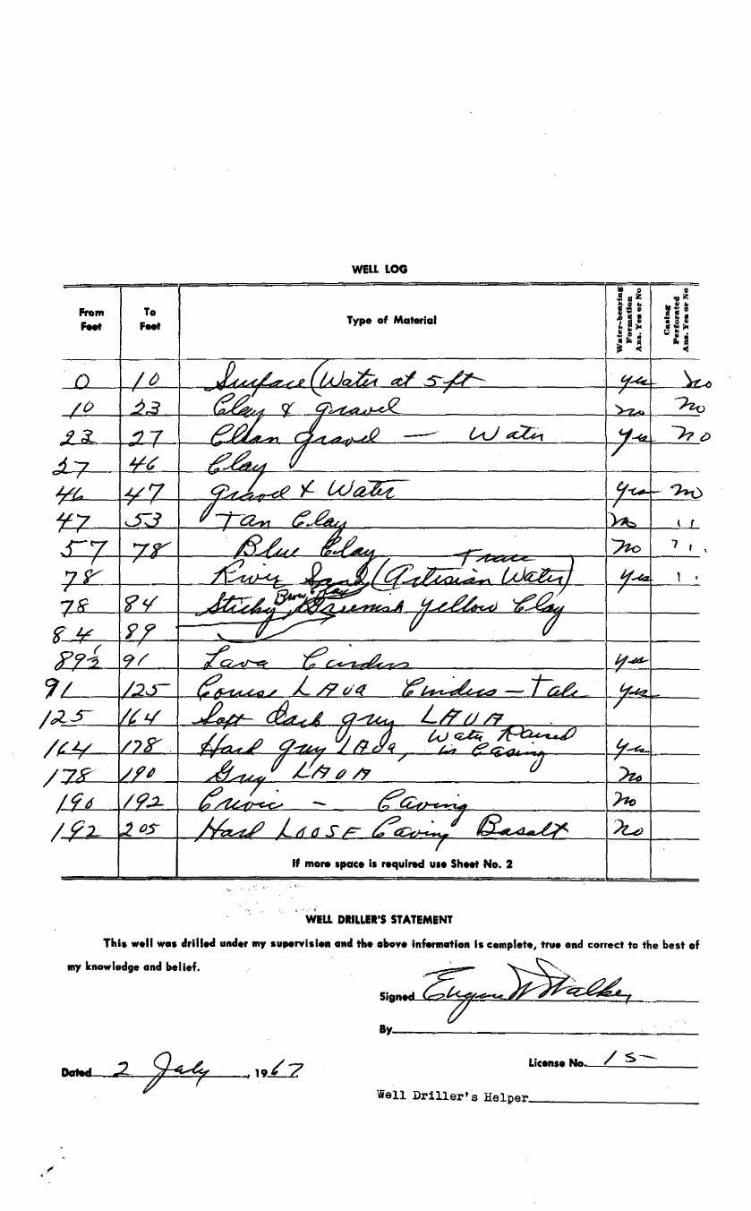
From Feet
To FNt
WELL LOG
Type of Material
If more space Is required use Sheet No. 2
', .....
. ,. '. ~· WELL DIILLEl'S STATEMENT
7 r '
l '
This well was drilled under my supervislen a11d the altove infermatlon Is complete, true and correct to the best of
my knowledge and belief.
BY---------------~---
/ s--License No---=-------
Well Driller's Helper __________ _

'--.,ell Log Form l
2M-5-65
From Feet
oZJ s· ,2_¥Y
~.¥y·
;its-
To Feet
SHEET NO. 2
03'1406Well ~~~:;~,~~ b. Well Driller IUGINI w., WAuca
'24...,ceSt. Well Location ___ lwl_n_l'a __ ff...:..s,_ld---'a=ho"'-
WELL LOG
Wciter-becirlng Ccising TYPE OF MATERIAL Formation Perforcited
Ans, Yes or No Ans. Yes or No
7

1
STATE OF IDAHODEPARTMENT OF WATER RESOURCES
TEMPORARY CHANGE APPLICATION(To change point of diversion, place of use, or purpose of use of a water right upondeclaration of a drought emergency in accordance with Section 42-222A, Idaho Code.)
Name of Applicant Phone
Mailing Address Email
A. PURPOSE OF TRANSFER1. Change point of diversion Add diversion point(s) Change place of use
Change purpose of use Other
2. Describe the proposed change(s) and explain the reason(s) they are needed.
B. DESCRIPTION OF RIGHT(S) OR PORTION THEREOF, AFTER THE REQUESTED CHANGE1. Right Number Priority Amount Nature of Use Period of Use (cfs/ac-ft)
to
to
to
to
2. Total amount of water being transferred cubic feet per second and/or acre-feet per annum.
3. Source of water tributary to .
4. Point(s) of diversion:
Twp Rge Sec GovtLot ¼ ¼ ¼ County Source Local name or
tag number
5. Lands irrigated or place of use:
Twp Rge Sec NE ¼ NW ¼ SW ¼ SE ¼ Acre
TotalsNE NW SW SE NE NW SW SE NE NW SW SE NE NW SW SE
Total Acres
South Valley &/or Galena Ground Water Districts 208-336-0700
PO Box 2139, Boise, ID 83701 [email protected]
Ground water rights not in use in 2021 are proposed to be used for mitigation by pumping from select wells into
Silver Creek to augment the discharge of the Little Wood River to benefit senior priority water rights.
37-23093 4/1/1984 2.65 Irrigation 4/15 10/31
37-23090 11/13/1959 7.16 Irrigation 4/1 11/01
37-23091 8/1/1960 3.61 Irrigation 4/15 10/31
37-23092 8/20/1964 8.89 Irrigation 4/1 11/1
15.00
Ground Water
1S 20E 20 NW NE NE Blaine Ground Water No Log - RF = 0.1035NE SW " " No Log - RF = 0.147
SE SW SE " "30 NW SW NE " "

1
STATE OF IDAHODEPARTMENT OF WATER RESOURCES
TEMPORARY CHANGE APPLICATION(To change point of diversion, place of use, or purpose of use of a water right upondeclaration of a drought emergency in accordance with Section 42-222A, Idaho Code.)
Name of Applicant Phone
Mailing Address Email
A. PURPOSE OF TRANSFER1. Change point of diversion Add diversion point(s) Change place of use
Change purpose of use Other
2. Describe the proposed change(s) and explain the reason(s) they are needed.
B. DESCRIPTION OF RIGHT(S) OR PORTION THEREOF, AFTER THE REQUESTED CHANGE1. Right Number Priority Amount Nature of Use Period of Use (cfs/ac-ft)
to
to
to
to
2. Total amount of water being transferred cubic feet per second and/or acre-feet per annum.
3. Source of water tributary to .
4. Point(s) of diversion:
Twp Rge Sec GovtLot ¼ ¼ ¼ County Source Local name or
tag number
5. Lands irrigated or place of use:
Twp Rge Sec NE ¼ NW ¼ SW ¼ SE ¼ Acre
TotalsNE NW SW SE NE NW SW SE NE NW SW SE NE NW SW SE
Total Acres
For additional PODs & Water Rights only.
37-2581 8/16/1955 3.00 Irrigation 4/15 10/31
37-2599 9/30/1957 1.50 Irrigation 4/15 10/31
37-2604 7/29/1958 2.50 Irrigation 4/15 10/31
37-2616 6/3/1959 2.98 Irrigation 4/15 10/31
1S 20E 30 NE NW Blaine Ground Water19E 2 SW NW SW Blaine Ground Water
SE NW SW Blaine Ground Water5 1 SE NE Blaine Ground Water
□ □
□ □
□
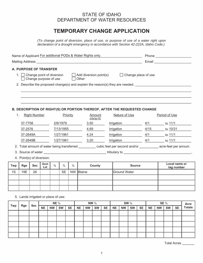
1
STATE OF IDAHODEPARTMENT OF WATER RESOURCES
TEMPORARY CHANGE APPLICATION(To change point of diversion, place of use, or purpose of use of a water right upondeclaration of a drought emergency in accordance with Section 42-222A, Idaho Code.)
Name of Applicant Phone
Mailing Address Email
A. PURPOSE OF TRANSFER1. Change point of diversion Add diversion point(s) Change place of use
Change purpose of use Other
2. Describe the proposed change(s) and explain the reason(s) they are needed.
B. DESCRIPTION OF RIGHT(S) OR PORTION THEREOF, AFTER THE REQUESTED CHANGE1. Right Number Priority Amount Nature of Use Period of Use (cfs/ac-ft)
to
to
to
to
2. Total amount of water being transferred cubic feet per second and/or acre-feet per annum.
3. Source of water tributary to .
4. Point(s) of diversion:
Twp Rge Sec GovtLot ¼ ¼ ¼ County Source Local name or
tag number
5. Lands irrigated or place of use:
Twp Rge Sec NE ¼ NW ¼ SW ¼ SE ¼ Acre
TotalsNE NW SW SE NE NW SW SE NE NW SW SE NE NW SW SE
Total Acres
For additional PODs & Water Rights only.
37-7758 2/6/1979 3.50 Irrigation 4/1 11/1
37-2576 7/13/1955 4.69 Irrigation 4/15 10/31
37-2649A 1/27/1961 4.24 Irrigation 4/1 11/1
37-2649B 1/27/1961 3.20 Irrigation 4/1 11/1
1S 19E 28 SE NW Blaine Ground Water
□ □
□ □
□

1
STATE OF IDAHODEPARTMENT OF WATER RESOURCES
TEMPORARY CHANGE APPLICATION(To change point of diversion, place of use, or purpose of use of a water right upondeclaration of a drought emergency in accordance with Section 42-222A, Idaho Code.)
Name of Applicant Phone
Mailing Address Email
A. PURPOSE OF TRANSFER1. Change point of diversion Add diversion point(s) Change place of use
Change purpose of use Other
2. Describe the proposed change(s) and explain the reason(s) they are needed.
B. DESCRIPTION OF RIGHT(S) OR PORTION THEREOF, AFTER THE REQUESTED CHANGE1. Right Number Priority Amount Nature of Use Period of Use
(cfs/ac-ft)
to
to
to
to
2. Total amount of water being transferred cubic feet per second and/or acre-feet per annum.
3. Source of water tributary to .
4. Point(s) of diversion:
Twp Rge Sec GovtLot ¼ ¼ ¼ County Source Local name or
tag number
5. Lands irrigated or place of use:
Twp Rge Sec NE ¼ NW ¼ SW ¼ SE ¼ Acre
TotalsNE NW SW SE NE NW SW SE NE NW SW SE NE NW SW SE
Total Acres
For additional Water Rights only.
37-2681 12/08/1961 4.5 Irrigation 4/1 10/31
37-7644 8/20/1977 2.02 Irrigation 4/15 10/31
37-8559 8/17/1989 1.15 Irrigation 4/15 10/31
37-2493 12/21/1948 2.00 Irrigation 4 / 1 5 10/31
□ □
□ □
□

2
6. General Information:
a. Who owns the water right to be changed?
b. Describe the arrangement allowing use of the right.
c. Describe the affect on the land now irrigated if the change is approved pursuant to this application:
d. Has the water right sought to be transferred been used this year? Yes No If yes, explain.
e. Absent the changes, how would the right be used for the remainder of the year?
f. Describe other water rights used for the same purpose.
g. Remarks:
I hereby assume all risk in accordance with Section 42-222A, Idaho Code, and assert that no one will be injured by such change and that the change does not constitute an enlargement in use of the original right. The information contained in this application is true to the best of my knowledge. I understand that any willful misrepresentations made in this application may result in voiding its approval.
Signature of Applicant Date
FOR DEPARTMENT USE ONLY
Received by Date $50 fee receipted by Receipt No.
Recommend: approve deny Watermaster recommendation
ACTION OF THE DIRECTOR, DEPARTMENT OF WATER RESOURCES
This is to certify that I have examined Temporary Change Application No. , and said
application is hereby , subject to the following limitations and conditions:
Temporary Change Expiriation Date
Signed this day of , .
For the Director
Blackburn Farming LLC, O'Gara (Speth), StevensonSharing agreement with South Valley and Galena Ground
Water Districts, Water Bank
Water rights are not being used in 2021 & there will be no impact to the lands these rights are appurtenant to.
Remain unused.
None except those identified in this application.
This transfer seeks to augment the discharge of Silver Creek and the Little Wood River to supply waterto mitigate the water supply for Little Wood River water users.
□ □

Memorandum in Support of Temporary Transfer to Supplement Little Wood River Water Supply
Water from 155 acres not being irrigated this year will be provided from portions of water rights 37-23090, 37-23091, 37-23092 and 37-23093 not currently being used. The place of use for these 3 water rights has been reshaped this year with over 200 acres not being irrigated that are within the place of use of these 4 water rights. The lands have been identified through the overlay of a sketch map with the current place of use of the water rights, copy attached. A more precise mapping can be prepared of the idle acres if needed as time permits.
An additional 302 acres currently leased to the Water Supply Bank are not being irrigated and the water from those acres is available to augment the water supply of the Little Wood River. The 302 acres comes from a portion of water rights 37-2581, 37-2599, 37-2604, 37-2616 and 37-7758. A map of the fallowed acres is attached to this package.
About 893 acres covered by ground water rights are not being irrigated this year by Stevenson. Also, Lakeside Industries are not irrigating 157 acres covered by ground water rights.
Up to 9 cfs of ground water will be diverted from wells shown on the Temporary Change Application this Memorandum is accompanying. This 9 cfs will be in addition to the ground water being specifically pumped to augment the water supply for water rights 37-49 and 37-423. The RF shown on the Application, for the wells without a well log, is the response function taken from the support files accompanying Jennifer Sukow’s May 17, 2021 Memorandum titled “Predicted hydrologic response in Silver Creek and the Little Wood River to curtailment of groundwater use in 2021, Basin 37 Administrative Proceeding, AA-WRA-2021-001.” The response function is the fraction of the diverted water estimated to appear in Silver Creek by the end of September 2021.

Department of
WATER RIGHT REPORT
6/18/2021
IDAHO DEPARTMENT OF WATER RESOURCES
Water Right Report
WATER RIGHT NO. 37-23090
Owner Type Name and AddressCurrent Owner BLACKBURN FARMING LLC
535 GANNETT RD UNIT EBELLEVUE, ID 83313-50452084810348
Trustee MICHAEL LOVAS13233 SNOWSHOE THOMPSON CIRTRUCKEE, CA 961619255770293
Original Owner NMS LEASING INCBANK OF HAWAIIATTN: MS KIM YOSHIMOTO130 MERCHANT STHONOLULU, HI 968028085384737
Original Owner K F HELLYERHWY 68GANNETT, ID 83329
Security Interest LOVAS TRUST13233 SNOWSHOE THOMPSON CIRTRUCKEE, CA 96161-51819255770293
Priority Date: 11/13/1959
Basis: Decreed
Status: Active
Source TributaryGROUND WATER
Beneficial Use From To Diversion Rate VolumeIRRIGATION 04/01 11/01 7.16 CFS 1256.8 AFATotal Diversion 7.16 CFS 1256.8 AFA
Location of Point(s) of Diversion:
GROUND WATER NWSWNW Sec. 17 Township 01N Range 19E BLAINE CountyGROUND WATER NENENW Sec. 20 Township 01N Range 19E BLAINE CountyGROUND WATER SWSENW Sec. 28 Township 01N Range 19E BLAINE CountyIRRIGATION Use:
Acre Limit: 359.1
Place(s) of use:
Place of Use Legal Description: IRRIGATION BLAINE County
Township Range Section Lot Tract Acres Lot Tract Acres Lot Tract Acres Lot Tract Acres01N 19E 17 SWNE 38
SWNW 31 SENW 40NESW 40 NWSW 13 SESW 26
IDWR offices are open to the public and following the CDC guidelines for wearing masks and observing social
distancing. For in-person visits, we encourage you to call ahead for an appointment.
Home / Water Rights / Research / Search Water Rights
Water Right Report https://idwr.idaho.gov/apps/ExtSearch/RightReportAJ.asp?BasinNumber=37&Seque...
1 of 3 6/18/2021, 2:38 PM
JDAJ--{Owater Resources ~
X

NESE 11 NWSE 40 SWSE 40 SESE 2220 NENE 39 NWNE 38.5 SWNE 19 SENE 40
NENW 7NESE 35 NWSE 1.3 SESE 13
21 8 NWNW 10 9 SWNW 911 NWSW 24 SWSW 36 12 SESW 1.2
27 NENE 11 NWNE 9 SWNE 40 SENE 11SWNW 13 SENW 30NESW 40 NWSW 38 SWSW 40 SESW 30NESE 3.8 NWSE 36 SWSE 4
28 SWNE 14 SENE 4NENW 13 NWNW 29 SWNW 6.4 SENW 37NESW 22 SESW 2.2NESE 39 NWSE 39 SWSE 36 SESE 40
33 NENE 40 NWNE 14 SENE 3034 NENW 0.2 NWNW 31 SWNW 15
Total Acres: 1291.6
Conditions of Approval:
1. Total combined delivery at the field headgates (for surface water rights) and diversion at the wellheads (for groundwater rights) for this right along with water right nos. 37-23083, 37-23084, 37-23085, 37-23086, 37-23087, 37-23088,37-23089, 37-23090, 37-23091, 37-23092 and 37-23093 shall not exceed a total instantaneous rate of 25.8 cfs (whichequates to 0.02 cfs per acre over the combined permissible places of use for these water rights totaling 1291.6 acres).
2. Total volume of water delivered to the field from this right along with water right nos. 37-481B, 37-482G, 37-483B,37-665K, 37-666J, 37-667N, 37-2625A, 37-2638, 37-2700, 37-21463, and 37-22155 shall not exceed 4626.9 acre-feet peryear (which equates to 3.5 acre-feet per acre over the combined permissible places of use for these water rightstotaling 1291.6 acres).
3. C05 Right includes accomplished change in place of use pursuant to Section 42-1425, Idaho Code.4. Right Nos. 37-23090, 37-23091, 37-23092 and 37-23093 are limited to the irrigation of a combined total of 1291.6 acres
in a single irrigation season.5. E52 The rights listed below are limited to a total combined diversion rate of 19.65 cfs. Combined Right Nos.: 37-23090,
37-23091, 37-23092 and 37-23093.6. C18 This partial decree is subject to such general provisions necessary for the definition of the rights or for the efficient
administration of the water rights as may be ultimately determined by the Court at a point in time no later than theentry of a final unified decree. Section 42-1412(6), Idaho Code.
7. 104 If the surface water rights appurtenant to the place of use is sold, transferred, leased or used on any other place ofuse, this right to divert ground water shall not be used without an approved transfer pursuant to Section 42-222, IdahoCode, or approval of the Department if a transfer is not required.
8. C03 Right includes accomplished change in point of diversion pursuant to Section 42-1425, Idaho Code.9. K06 This right is limited to the irrigation of 359.1 acres within the place of use described above in a single irrigation season.10. K01 Right No. 37-23093 is an enlargement of this right pursuant to Section 42-1426, Idaho Code.11. Right Nos. 37-23083, 37-23084, 37-23085, 37-23086, 37-23087, 37-23088, 37-23089, 37-23090, 37-23091, 37-23092 and
37-23093 are limited to the irrigation of a combined total of 1291.6 acres in a single irrigation season.12. 065 The right holder shall make full beneficial use of all surface water rights available to the right holder for irrigation of
the lands authorized to be irrigated under this right. The right holder shall limit the diversion of ground water underthis right to those times when the surface water supply is not available or the surface water supply is not reasonablysufficient to irrigate the place of use authorized under this right.
Dates:
Licensed Date:
Decreed Date: 01/14/2009
Enlargement Use Priority Date:
Enlargement Statute Priority Date:
Water Supply Bank Enrollment Date Accepted:
Water Supply Bank Enrollment Date Removed:
Application Received Date:
Protest Deadline Date:
Number of Protests: 0
Other Information:
State or Federal: S
Owner Name Connector:
Water District Number: 37
Generic Max Rate per Acre:
Generic Max Volume per Acre:
Combined Acres Limit: 1291.6
Combined Volume Limit: 19.7
Combined Rate Limit:
Civil Case Number:
Water Right Report https://idwr.idaho.gov/apps/ExtSearch/RightReportAJ.asp?BasinNumber=37&Seque...
2 of 3 6/18/2021, 2:38 PM

Old Case Number:
Decree Plantiff:
Decree Defendant:
Swan Falls Trust or Nontrust:
Swan Falls Dismissed:
DLE Act Number:
Cary Act Number:
Mitigation Plan: False
Water Right Report https://idwr.idaho.gov/apps/ExtSearch/RightReportAJ.asp?BasinNumber=37&Seque...
3 of 3 6/18/2021, 2:38 PM
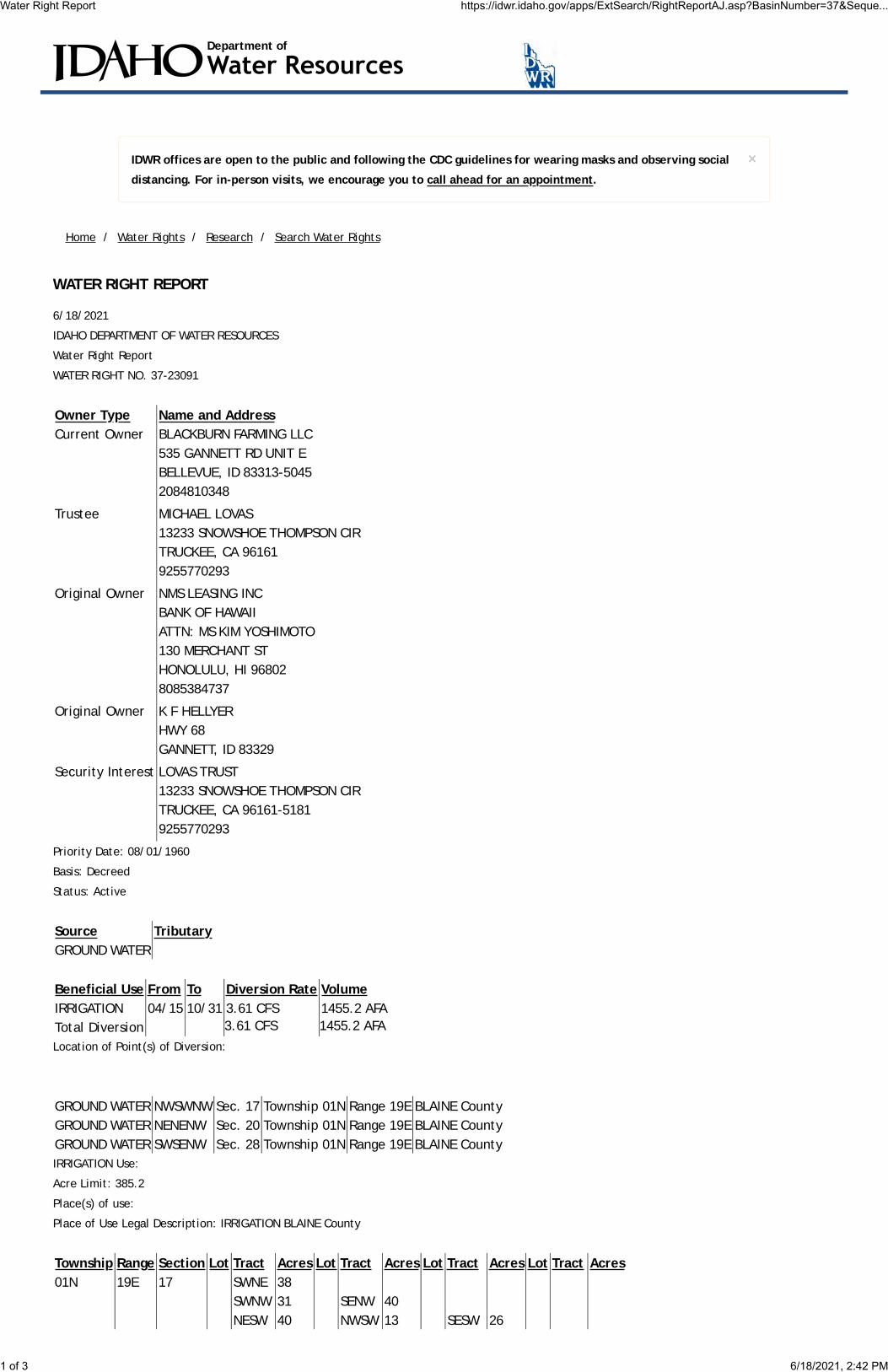
Department of
WATER RIGHT REPORT
6/18/2021
IDAHO DEPARTMENT OF WATER RESOURCES
Water Right Report
WATER RIGHT NO. 37-23091
Owner Type Name and AddressCurrent Owner BLACKBURN FARMING LLC
535 GANNETT RD UNIT EBELLEVUE, ID 83313-50452084810348
Trustee MICHAEL LOVAS13233 SNOWSHOE THOMPSON CIRTRUCKEE, CA 961619255770293
Original Owner NMS LEASING INCBANK OF HAWAIIATTN: MS KIM YOSHIMOTO130 MERCHANT STHONOLULU, HI 968028085384737
Original Owner K F HELLYERHWY 68GANNETT, ID 83329
Security Interest LOVAS TRUST13233 SNOWSHOE THOMPSON CIRTRUCKEE, CA 96161-51819255770293
Priority Date: 08/01/1960
Basis: Decreed
Status: Active
Source TributaryGROUND WATER
Beneficial Use From To Diversion Rate VolumeIRRIGATION 04/15 10/31 3.61 CFS 1455.2 AFATotal Diversion 3.61 CFS 1455.2 AFA
Location of Point(s) of Diversion:
GROUND WATER NWSWNW Sec. 17 Township 01N Range 19E BLAINE CountyGROUND WATER NENENW Sec. 20 Township 01N Range 19E BLAINE CountyGROUND WATER SWSENW Sec. 28 Township 01N Range 19E BLAINE CountyIRRIGATION Use:
Acre Limit: 385.2
Place(s) of use:
Place of Use Legal Description: IRRIGATION BLAINE County
Township Range Section Lot Tract Acres Lot Tract Acres Lot Tract Acres Lot Tract Acres01N 19E 17 SWNE 38
SWNW 31 SENW 40NESW 40 NWSW 13 SESW 26
IDWR offices are open to the public and following the CDC guidelines for wearing masks and observing social
distancing. For in-person visits, we encourage you to call ahead for an appointment.
Home / Water Rights / Research / Search Water Rights
Water Right Report https://idwr.idaho.gov/apps/ExtSearch/RightReportAJ.asp?BasinNumber=37&Seque...
1 of 3 6/18/2021, 2:42 PM
JDAJ--{Owater Resources ~
X
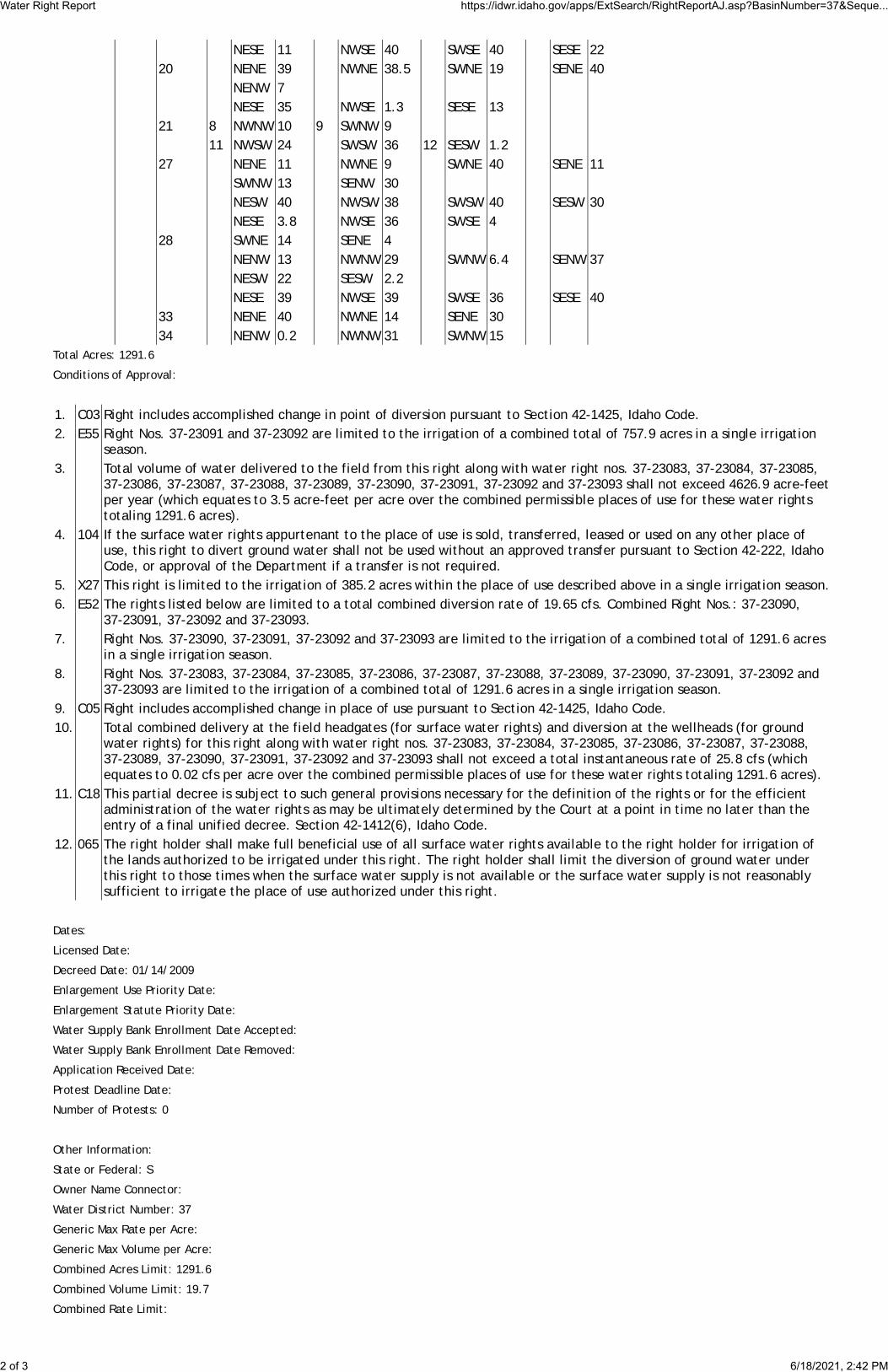
NESE 11 NWSE 40 SWSE 40 SESE 2220 NENE 39 NWNE 38.5 SWNE 19 SENE 40
NENW 7NESE 35 NWSE 1.3 SESE 13
21 8 NWNW 10 9 SWNW 911 NWSW 24 SWSW 36 12 SESW 1.2
27 NENE 11 NWNE 9 SWNE 40 SENE 11SWNW 13 SENW 30NESW 40 NWSW 38 SWSW 40 SESW 30NESE 3.8 NWSE 36 SWSE 4
28 SWNE 14 SENE 4NENW 13 NWNW 29 SWNW 6.4 SENW 37NESW 22 SESW 2.2NESE 39 NWSE 39 SWSE 36 SESE 40
33 NENE 40 NWNE 14 SENE 3034 NENW 0.2 NWNW 31 SWNW 15
Total Acres: 1291.6
Conditions of Approval:
1. C03 Right includes accomplished change in point of diversion pursuant to Section 42-1425, Idaho Code.2. E55 Right Nos. 37-23091 and 37-23092 are limited to the irrigation of a combined total of 757.9 acres in a single irrigation
season.3. Total volume of water delivered to the field from this right along with water right nos. 37-23083, 37-23084, 37-23085,
37-23086, 37-23087, 37-23088, 37-23089, 37-23090, 37-23091, 37-23092 and 37-23093 shall not exceed 4626.9 acre-feetper year (which equates to 3.5 acre-feet per acre over the combined permissible places of use for these water rightstotaling 1291.6 acres).
4. 104 If the surface water rights appurtenant to the place of use is sold, transferred, leased or used on any other place ofuse, this right to divert ground water shall not be used without an approved transfer pursuant to Section 42-222, IdahoCode, or approval of the Department if a transfer is not required.
5. X27 This right is limited to the irrigation of 385.2 acres within the place of use described above in a single irrigation season.6. E52 The rights listed below are limited to a total combined diversion rate of 19.65 cfs. Combined Right Nos.: 37-23090,
37-23091, 37-23092 and 37-23093.7. Right Nos. 37-23090, 37-23091, 37-23092 and 37-23093 are limited to the irrigation of a combined total of 1291.6 acres
in a single irrigation season.8. Right Nos. 37-23083, 37-23084, 37-23085, 37-23086, 37-23087, 37-23088, 37-23089, 37-23090, 37-23091, 37-23092 and
37-23093 are limited to the irrigation of a combined total of 1291.6 acres in a single irrigation season.9. C05 Right includes accomplished change in place of use pursuant to Section 42-1425, Idaho Code.10. Total combined delivery at the field headgates (for surface water rights) and diversion at the wellheads (for ground
water rights) for this right along with water right nos. 37-23083, 37-23084, 37-23085, 37-23086, 37-23087, 37-23088,37-23089, 37-23090, 37-23091, 37-23092 and 37-23093 shall not exceed a total instantaneous rate of 25.8 cfs (whichequates to 0.02 cfs per acre over the combined permissible places of use for these water rights totaling 1291.6 acres).
11. C18 This partial decree is subject to such general provisions necessary for the definition of the rights or for the efficientadministration of the water rights as may be ultimately determined by the Court at a point in time no later than theentry of a final unified decree. Section 42-1412(6), Idaho Code.
12. 065 The right holder shall make full beneficial use of all surface water rights available to the right holder for irrigation ofthe lands authorized to be irrigated under this right. The right holder shall limit the diversion of ground water underthis right to those times when the surface water supply is not available or the surface water supply is not reasonablysufficient to irrigate the place of use authorized under this right.
Dates:
Licensed Date:
Decreed Date: 01/14/2009
Enlargement Use Priority Date:
Enlargement Statute Priority Date:
Water Supply Bank Enrollment Date Accepted:
Water Supply Bank Enrollment Date Removed:
Application Received Date:
Protest Deadline Date:
Number of Protests: 0
Other Information:
State or Federal: S
Owner Name Connector:
Water District Number: 37
Generic Max Rate per Acre:
Generic Max Volume per Acre:
Combined Acres Limit: 1291.6
Combined Volume Limit: 19.7
Combined Rate Limit:
Water Right Report https://idwr.idaho.gov/apps/ExtSearch/RightReportAJ.asp?BasinNumber=37&Seque...
2 of 3 6/18/2021, 2:42 PM

Civil Case Number:
Old Case Number:
Decree Plantiff:
Decree Defendant:
Swan Falls Trust or Nontrust:
Swan Falls Dismissed:
DLE Act Number:
Cary Act Number:
Mitigation Plan: False
Water Right Report https://idwr.idaho.gov/apps/ExtSearch/RightReportAJ.asp?BasinNumber=37&Seque...
3 of 3 6/18/2021, 2:42 PM

Department of
WATER RIGHT REPORT
6/18/2021
IDAHO DEPARTMENT OF WATER RESOURCES
Water Right Report
WATER RIGHT NO. 37-23092
Owner Type Name and AddressCurrent Owner BLACKBURN FARMING LLC
535 GANNETT RD UNIT EBELLEVUE, ID 83313-50452084810348
Trustee MICHAEL LOVAS13233 SNOWSHOE THOMPSON CIRTRUCKEE, CA 961619255770293
Original Owner NMS LEASING INCOriginal Owner K F HELLYER
BANK OF HAWAIIATTN: MS KIM YOSHIMOTO130 MERCHANT STHONOLULU, HI 968028085384737
Original Owner FRED BROSSYCOVE RANCHBELLEVUE, ID 83313
Security Interest LOVAS TRUST13233 SNOWSHOE THOMPSON CIRTRUCKEE, CA 96161-51819255770293
Priority Date: 08/20/1964
Basis: Decreed
Status: Active
Source TributaryGROUND WATER
Beneficial Use From To Diversion Rate VolumeIRRIGATION 04/01 11/01 8.89 CFS 1333.8 AFATotal Diversion 8.89 CFS 1333.8 AFA
Location of Point(s) of Diversion:
GROUND WATER NWSWNW Sec. 17 Township 01N Range 19E BLAINE CountyGROUND WATER NENENW Sec. 20 Township 01N Range 19E BLAINE CountyGROUND WATER SWSENW Sec. 28 Township 01N Range 19E BLAINE CountyIRRIGATION Use:
Acre Limit: 444.6
Place(s) of use:
Place of Use Legal Description: IRRIGATION BLAINE County
Township Range Section Lot Tract Acres Lot Tract Acres Lot Tract Acres Lot Tract Acres01N 19E 17 SWNE 38
SWNW 31 SENW 40
IDWR offices are open to the public and following the CDC guidelines for wearing masks and observing social
distancing. For in-person visits, we encourage you to call ahead for an appointment.
Home / Water Rights / Research / Search Water Rights
Water Right Report https://idwr.idaho.gov/apps/ExtSearch/RightReportAJ.asp?BasinNumber=37&Seque...
1 of 3 6/18/2021, 2:39 PM
JDAJ--{Owater Resources ~
X

NESW 40 NWSW 13 SESW 26NESE 11 NWSE 40 SWSE 40 SESE 22
20 NENE 39 NWNE 38.5 SWNE 19 SENE 40NENW 7NESE 35 NWSE 1.3 SESE 13
21 8 NWNW 10 9 SWNW 911 NWSW 24 SWSW 36 12 SESW 1.2
27 NENE 11 NWNE 9 SWNE 40 SENE 11SWNW 13 SENW 30NESW 40 NWSW 38 SWSW 40 SESW 30NESE 3.8 NWSE 36 SWSE 4
28 SWNE 14 SENE 4NENW 13 NWNW 29 SWNW 6.4 SENW 37NESW 22 SESW 2.2NESE 39 NWSE 39 SWSE 36 SESE 40
33 NENE 40 NWNE 14 SENE 3034 NENW 0.2 NWNW 31 SWNW 15
Total Acres: 1291.6
Conditions of Approval:
1. Total combined delivery at the field headgates (for surface water rights) and diversion at the wellheads (for groundwater rights) for this right along with water right nos. 37-23083, 37-23084, 37-23085, 37-23086, 37-23087, 37-23088,37-23089, 37-23090, 37-23091, 37-23092 and 37-23093 shall not exceed a total instantaneous rate of 25.8 cfs (whichequates to 0.02 cfs per acre over the combined permissible places of use for these water rights totaling 1291.6 acres).
2. 104 If the surface water rights appurtenant to the place of use is sold, transferred, leased or used on any other place ofuse, this right to divert ground water shall not be used without an approved transfer pursuant to Section 42-222, IdahoCode, or approval of the Department if a transfer is not required.
3. E55 Right Nos. 37-23091 and 37-23092 are limited to the irrigation of a combined total of 757.9 acres in a single irrigationseason.
4. 065 The right holder shall make full beneficial use of all surface water rights available to the right holder for irrigation ofthe lands authorized to be irrigated under this right. The right holder shall limit the diversion of ground water underthis right to those times when the surface water supply is not available or the surface water supply is not reasonablysufficient to irrigate the place of use authorized under this right.
5. X27 This right is limited to the irrigation of 444.6 acres within the place of use described above in a single irrigation season.6. C18 This partial decree is subject to such general provisions necessary for the definition of the rights or for the efficient
administration of the water rights as may be ultimately determined by the Court at a point in time no later than theentry of a final unified decree. Section 42-1412(6), Idaho Code.
7. Right Nos. 37-23090, 37-23091, 37-23092 and 37-23093 are limited to the irrigation of a combined total of 1291.6 acresin a single irrigation season.
8. Right Nos. 37-23083, 37-23084, 37-23085, 37-23086, 37-23087, 37-23088, 37-23089, 37-23090, 37-23091, 37-23092 and37-23093 are limited to the irrigation of a combined total of 1291.6 acres in a single irrigation season.
9. C05 Right includes accomplished change in place of use pursuant to Section 42-1425, Idaho Code.10. E52 The rights listed below are limited to a total combined diversion rate of 19.65 cfs. Combined Right Nos.: 37-23090,
37-23091, 37-23092 and 37-23093.11. C03 Right includes accomplished change in point of diversion pursuant to Section 42-1425, Idaho Code.12. Total volume of water delivered to the field from this right along with water right nos. 37-23083, 37-23084, 37-23085,
37-23086, 37-23087, 37-23088, 37-23089, 37-23090, 37-23091, 37-23092 and 37-23093 shall not exceed 4626.9 acre-feetper year (which equates to 3.5 acre-feet per acre over the combined permissible places of use for these water rightstotaling 1291.6 acres).
Dates:
Licensed Date:
Decreed Date: 01/14/2009
Enlargement Use Priority Date:
Enlargement Statute Priority Date:
Water Supply Bank Enrollment Date Accepted:
Water Supply Bank Enrollment Date Removed:
Application Received Date:
Protest Deadline Date:
Number of Protests: 0
Other Information:
State or Federal: S
Owner Name Connector:
Water District Number: 37
Generic Max Rate per Acre:
Generic Max Volume per Acre:
Combined Acres Limit: 1291.6
Combined Volume Limit: 19.7
Water Right Report https://idwr.idaho.gov/apps/ExtSearch/RightReportAJ.asp?BasinNumber=37&Seque...
2 of 3 6/18/2021, 2:39 PM

Combined Rate Limit:
Civil Case Number:
Old Case Number:
Decree Plantiff:
Decree Defendant:
Swan Falls Trust or Nontrust:
Swan Falls Dismissed:
DLE Act Number:
Cary Act Number:
Mitigation Plan: False
Water Right Report https://idwr.idaho.gov/apps/ExtSearch/RightReportAJ.asp?BasinNumber=37&Seque...
3 of 3 6/18/2021, 2:39 PM

Department of
WATER RIGHT REPORT
6/18/2021
IDAHO DEPARTMENT OF WATER RESOURCES
Water Right Report
WATER RIGHT NO. 37-23093
Owner Type Name and AddressCurrent Owner BLACKBURN FARMING LLC
535 GANNETT RD UNIT EBELLEVUE, ID 83313-50452084810348
Trustee MICHAEL LOVAS13233 SNOWSHOE THOMPSON CIRTRUCKEE, CA 961619255770293
Original Owner NMS LEASING INCBANK OF HAWAIIATTN: MS KIM YOSHIMOTO130 MERCHANT STHONOLULU, HI 968028085384737
Security Interest LOVAS TRUST13233 SNOWSHOE THOMPSON CIRTRUCKEE, CA 96161-51819255770293
Priority Date: 04/01/1984
Basis: Decreed
Status: Active
Source TributaryGROUND WATER
Beneficial Use From To Diversion Rate VolumeIRRIGATION 04/15 10/31 2.65 CFS 611.1 AFATotal Diversion 2.65 CFS 611.1 AFA
Location of Point(s) of Diversion:
GROUND WATER NWSWNW Sec. 17 Township 01N Range 19E BLAINE CountyGROUND WATER NENENW Sec. 20 Township 01N Range 19E BLAINE CountyGROUND WATER SWSENW Sec. 28 Township 01N Range 19E BLAINE CountyIRRIGATION Use:
Acre Limit: 174.6
Place(s) of use:
Place of Use Legal Description: IRRIGATION BLAINE County
Township Range Section Lot Tract Acres Lot Tract Acres Lot Tract Acres Lot Tract Acres01N 19E 17 SWNE 38
SWNW 31 SENW 40NESW 40 NWSW 13 SESW 26NESE 11 NWSE 40 SWSE 40 SESE 22
20 NENE 39 NWNE 38.5 SWNE 19 SENE 40NENW 7
IDWR offices are open to the public and following the CDC guidelines for wearing masks and observing social
distancing. For in-person visits, we encourage you to call ahead for an appointment.
Home / Water Rights / Research / Search Water Rights
Water Right Report https://idwr.idaho.gov/apps/ExtSearch/RightReportAJ.asp?BasinNumber=37&Seque...
1 of 3 6/18/2021, 2:40 PM
JDAJ--{Owater Resources ~
X
NESE 35 NWSE 1.3 SESE 1321 8 NWNW 10 9 SWNW 9
11 NWSW 24 SWSW 36 12 SESW 1.227 NENE 11 NWNE 9 SWNE 40 SENE 11
SWNW 13 SENW 30NESW 40 NWSW 38 SWSW 40 SESW 30NESE 3.8 NWSE 36 SWSE 4
28 SWNE 14 SENE 4NENW 13 NWNW 29 SWNW 6.4 SENW 37NESW 22 SESW 2.2NESE 39 NWSE 39 SWSE 36 SESE 40
33 NENE 40 NWNE 14 SENE 3034 NENW 0.2 NWNW 31 SWNW 15
Total Acres: 1291.6
Conditions of Approval:
1. E52 The rights listed below are limited to a total combined diversion rate of 19.65 cfs. Combined Right Nos.: 37-23090,37-23091, 37-23092 and 37-23093.
2. Right Nos. 37-23083, 37-23084, 37-23085, 37-23086, 37-23087, 37-23088, 37-23089, 37-23090, 37-23091, 37-23092 and37-23093 are limited to the irrigation of a combined total of 1291.6 acres in a single irrigation season.
3. The rights listed below are limited to a total combined diversion rate of 7.16 cfs. Combined Right Nos.: 37-23090 and37-23093.
4. C11 This water right is subordinate to all water rights with a priority date earlier than April 12, 1994, that are not decreedas enlargements pursuant to Section 42-1426, Idaho Code. As between water rights decreed as enlargements pursuantto Section 42-1426, Idaho Code, the earlier priority right is the superior right.
5. Right Nos. 37-23090, 37-23091, 37-23092 and 37-23093 are limited to the irrigation of a combined total of 1291.6 acresin a single irrigation season.
6. Total combined delivery at the field headgates (for surface water rights) and diversion at the wellheads (for groundwater rights) for this right along with water right nos.37-23083, 37-23084, 37-23085, 37-23086, 37-23087, 37-23088,37-23089, 37-23090, 37-23091, 37-23092 and 37-23093 shall not exceed a total instantaneous rate of 25.8 cfs (whichequates to 0.02 cfs per acre over the combined permissible places of use for these water rights totaling 1291.6 acres).
7. 104 If the surface water rights appurtenant to the place of use is sold, transferred, leased or used on any other place ofuse, this right to divert ground water shall not be used without an approved transfer pursuant to Section 42-222, IdahoCode, or approval of the Department if a transfer is not required.
8. K01 This right is an enlargement of Right 37-23090, 37-23091 & 37-23092 pursuant to Section 42-1426, Idaho Code.9. C05 Right includes accomplished change in place of use pursuant to Section 42-1425, Idaho Code.10. C18 This partial decree is subject to such general provisions necessary for the definition of the rights or for the efficient
administration of the water rights as may be ultimately determined by the Court at a point in time no later than theentry of a final unified decree. Section 42-1412(6), Idaho Code.
11. Total volume of water delivered to the field from this right along with water right nos. 37-23083, 37-23084, 37-23085,37-23086, 37-23087, 37-23088, 37-23089, 37-23090, 37-23091, 37-23092 and 37-23093 shall not exceed 4626.9 acre-feetper year (which equates to 3.5 acre-feet per acre over the combined permissible places of use for these water rightstotaling 1291.6 acres).
12. X27 This right is limited to the irrigation of 174.6 acres within the place of use described above in a single irrigation season.13. 065 The right holder shall make full beneficial use of all surface water rights available to the right holder for irrigation of
the lands authorized to be irrigated under this right. The right holder shall limit the diversion of ground water underthis right to those times when the surface water supply is not available or the surface water supply is not reasonablysufficient to irrigate the place of use authorized under this right.
14. C03 Right includes accomplished change in point of diversion pursuant to Section 42-1425, Idaho Code.
Dates:
Licensed Date:
Decreed Date: 01/14/2009
Enlargement Use Priority Date:
Enlargement Statute Priority Date: 4/12/1994
Water Supply Bank Enrollment Date Accepted:
Water Supply Bank Enrollment Date Removed:
Application Received Date:
Protest Deadline Date:
Number of Protests: 0
Other Information:
State or Federal:
Owner Name Connector:
Water District Number: 37
Generic Max Rate per Acre:
Generic Max Volume per Acre:
Combined Acres Limit: 1291.6
Combined Volume Limit: 19.7
Combined Rate Limit:
Water Right Report https://idwr.idaho.gov/apps/ExtSearch/RightReportAJ.asp?BasinNumber=37&Seque...
2 of 3 6/18/2021, 2:40 PM

Civil Case Number:
Old Case Number:
Decree Plantiff:
Decree Defendant:
Swan Falls Trust or Nontrust:
Swan Falls Dismissed:
DLE Act Number:
Cary Act Number:
Mitigation Plan: False
Water Right Report https://idwr.idaho.gov/apps/ExtSearch/RightReportAJ.asp?BasinNumber=37&Seque...
3 of 3 6/18/2021, 2:40 PM

!.
!.
!.
7
35
98
26
22
15 1417
23
30
19
31
20
32 33
18
29 28
16
21
34
27
6 5 4
11
3
10
2
13
24
25
36
1
25
36
24
13
12 12
The USDA-FSA Aerial Photography Field office asks to becredited in derived products.
Map produced on June 21, 2021
18E 19E
19E 19E
01S
01
N 01N
01S
!. Point of Diversion
Place Of Use Boundary
Townships
PLS Sections
Quarter Quarters ´
0 1 20.5 Miles
State of IdahoDepartment of Water Resources
Water Right37-23090 - 3
IRRIGATION
The map depicts the place of use for the water use listed above and point(s) of diversion of this right as currently derived from interpretations of the paper records and is used solely for illustrative purposes. Discrepancies between the computer representation and the permanent document file will be resolved in favor of the actual water right documents in the water right file.
D D D D

Blackburn Farming LLCCove Ranch
11 Fields1,237.72 ac
Cove RanchTriangle Field
140.77 ac
Cove RanchSouth Pivot294.91 ac
Cove RanchEast Wheelines
65.28 ac
Cove RanchEast Pivot149.98 ac
Cove RanchEast Corner
12.69 acCove Ranch6
52.55 ac
Cove Ranch5
51.20 ac
Cove Ranch4
39.01 ac
Cove Ranch3
106.40 ac
Cove Ranch2
128.62 ac
Cove Ranch1
196.31 ac
Esri, HERE, Garmin, iPCEsri, HERE, Garmin, iPCEsri, HERE, Garmin, iPCEsri, HERE, Garmin, iPC | | | | Esri, HERE, iPCEsri, HERE, iPCEsri, HERE, iPCEsri, HERE, iPC | | | | USDA FSA, GeoEye, MaxarUSDA FSA, GeoEye, MaxarUSDA FSA, GeoEye, MaxarUSDA FSA, GeoEye, Maxar0000 0.10.10.10.1 0.2mi0.2mi0.2mi0.2mi
~ AGRintelligence Blackbum Fanning LLC
•
j "'
'
l
l

Department of
WATER RIGHT REPORT
6/18/2021
IDAHO DEPARTMENT OF WATER RESOURCES
Water Right Report
WATER RIGHT NO. 37-2581
Owner Type Name and AddressCurrent Owner THOMAS M O GARA FAMILY TRUST
C/O BRIAN BARSOTTIPO BOX 370KETCHUM, ID 833402087263030
Attorney PAUL L ARRINGTONBARKER ROSHOLT & SIMPSON LLP 163 2ND AVE W PO BOX 63TWIN FALLS, ID 83303-00632087330700
Trustee THOMAS O GARAPO BOX 2930HAILEY, ID 83333
Original Owner CHEMSPO BOX 237GOODING, ID 833302089344337
Security Interest D L EVANS BANKPO BOX 87TWIN FALLS, ID 83303-00872087369300
Priority Date: 08/16/1955
Basis: Decreed
Status: Active
Water Supply Bank Status: Active
Source TributaryGROUND WATER
Beneficial Use From To Diversion Rate VolumeIRRIGATION 04/15 10/31 3 CFS 1188 AFATotal Diversion 3 CFS 1188 AFA
Location of Point(s) of Diversion:
GROUND WATER NWSWNW Lt 4 Sec. 04 Township 01S Range 19E BLAINE CountyGROUND WATER NWNWSW Sec. 04 Township 01S Range 19E BLAINE CountyGROUND WATER NESWSE Sec. 17 Township 01S Range 19E BLAINE CountyIRRIGATION Use:
Acre Limit: 721.7
Place(s) of use:
Place of Use Legal Description: IRRIGATION BLAINE County
Township Range Section Lot Tract Acres Lot Tract Acres Lot Tract Acres Lot Tract Acres01S 19E 3 2 SWNE 6
4 SWNW 16 SENW 15NESW 40 NWSW 40
IDWR offices are open to the public and following the CDC guidelines for wearing masks and observing social
distancing. For in-person visits, we encourage you to call ahead for an appointment.
Home / Water Rights / Research / Search Water Rights
Water Right Report https://idwr.idaho.gov/apps/ExtSearch/RightReportAJ.asp?BasinNumber=37&Seque...
1 of 3 6/18/2021, 3:38 PM
JDAJ--{Owater Resources ~
X
NWSE 314 2 SWNE 17 1 SENE 16
4 SWNW 18 3 SENW 18NESW 40 NWSW 40 SWSW 40 SESW 40NESE 40 NWSE 40 SWSE 40 SESE 40
5 2 SWNE 19 1 SENE 19NESE 41 NWSE 41 SWSE 41 SESE 41
8 NENE 39 NWNE 39NESW 40 NWSW 40 SWSW 40 SESW 40NWSE 40 SWSE 40 SESE 20
9 NENE 40 NWNE 40 SWNE 40 SENE 40NENW 40 NWNW 40 SWNW 40 SENW 40NESW 41 NWSW 41 SWSW 41 SESW 41NESE 41 NWSE 41 SWSE 41 SESE 41
10 SWNE 40SWNW 21NESW 40 NWSW 40 SWSW 40 SESW 40NWSE 40 SWSE 40 SESE 40
15 NENE 40 NWNE 40 SWNE 40NENW 40 NWNW 40 SWNW 40 SENW 40NWSE 40 SWSE 37
16 NENE 41 NWNE 40 SWNE 40 SENE 41NENW 40 NWNW 39 SWNW 40 SENW 40NESW 41 NWSW 41 SWSW 38 SESW 38NESE 41 NWSE 41 SWSE 38 SESE 38
17 NESE 41 NWSE 40 SWSE 37 SESE 3820 NENE 40 NWNE 2021 NENW 40 NWNW 40 SENW 41
NESW 40Total Acres: 3437
Conditions of Approval:
1. X27 This right is limited to the irrigation of 721.7 acres within the authorized place of use in a single irrigation season.2. X35 Rights 37-2581, 37-2599, 37-2604, 37-2616, and 37-7758 when combined shall not exceed a total annual maximum
diversion volume of 2526 af at the field headgate and the irrigation of 721.7 acres.3. Rights 37-2581, 37-2599, 37-2604, 37-2616 and 37-7758 diverted from ground water are used as the sole source of water
for irrigation of a specific 721.7 acres within the 3437.0 acre place of use authorized by these rights in a singleirrigation season. Before changing the 721.7 acres to be irrigated within the 3437.0 acre place of use, the right holdershall submit a new land list and representative electronic shape file or map to the Department prior to the irrigationseason in which the change will occur. Note that the 721.7 acres is a subset of the 2119.9 acre total seasonal acre limitfor the rights included in transfer 80114.
4. X35 Rights 37-2502, 37-2568, 37-2581, 37-2599, 37-2604, 37-2616, 37-7758, 37-20635, 37-20637 and 37-20639 whencombined shall not exceed a total diversion rate of 34.59 cfs, a total annual maximum diversion volume of 6709.5 af atthe field headgate, and the irrigation of 2028.7 acres.
5. X35 Rights 37-804, 37-2502, 37-2568, 37-2581, 37-2599, 37-2604, 37-2616, 37-7758, 37-20635, 37-20637, and 37-20639 whencombined shall not exceed a total diversion rate of 36.41 cfs, a total annual maximum diversion volume of 7028.7 af atthe field headgate, and the irrigation of 2119.9 acres.
6. X35 Rights 37-115F, 37-501B, 37-501C, 37-577K, 37-590B, 37-597B, 37-2502, 37-2568, 37-2581, 37-2599, 37-2604, 37-2616,37-7758, 37-20635, 37-20637, 37-20639, 37-20641, 37-20643, 37-20645, 37-20647, 37-20649, and 37-20651 whencombined shall not exceed a total diversion rate of 53.88 cfs and the irrigation of 2028.7 acres.
7. X35 Rights 37-115F, 37-501B, 37-501C, 37-577K, 37-590B, 37-597B, 37-804, 37-2502, 37-2568, 37-2581, 37-2599, 37-2604,37-2616, 37-7758, 37-11830, 37-20635, 37-20637, 37-20639, 37-20641, 37-20643, 37-20645, 37-20647, 37-20649, and37-20651 when combined shall not exceed a total diversion rate of 55.70 cfs and the irrigation of 2119.9 acres.
8. 206 Rights 37-115F, 37-501B, 37-501C, 37-577K, 37-590B, 37-597B, 37-804, 37-2502, 37-2568, 37-2581, 37-2599, 37-2604,37-2616, 37-7758, 37-11830, 37-20635, 37-20637, 37-20639, 37-20641, 37-20643, 37-20645, 37-20647, 37-20649, and37-20651 are limited to the irrigation of a specific 2119.9 acres within the 3437.0 acre place of use authorized by theserights in a single irrigation season. The specific 2119.9 acres to be irrigated by the right holder are shown in theelectronic shape file associated with this right in the geographic information system component of the water rightsdatabase maintained by the department. Before changing the 2119.9 acres to be irrigated within the 3437.0 acre placeof use, the right holder shall submit a new land list and representative electronic shape file or map to the Departmentprior to the irrigation season in which the change will occur.
9. R05 Use of water under this right will be regulated by a watermaster with responsibility for the distribution of water amongappropriators within a water district. At the time of this approval, this water right is within State Water District No.37.
10. R43 The right holder shall maintain a measuring device and lockable controlling works of a type approved by theDepartment in a manner that will provide the watermaster suitable control of the diversions.
11. R63 This right when combined with all other rights shall provide no more than 0.02 cfs per acre nor more than 3.5 afa peracre at the field headgate for irrigation of the place of use.
12. T07 The right holder shall accomplish the change authorized by this transfer within one year of the date of this approval.13. T08 Failure of the right holder to comply with the conditions of this transfer is cause for the Director to rescind approval of
the transfer.
Water Right Report https://idwr.idaho.gov/apps/ExtSearch/RightReportAJ.asp?BasinNumber=37&Seque...
2 of 3 6/18/2021, 3:38 PM
14. T19 Pursuant to Section 42-1412(6), Idaho Code, this water right is subject to such general provisions necessary for thedefinition of the rights or for the efficient administration of water rights as may be determined by the Snake River BasinAdjudication court at a point in time no later than the entry of the final unified decree.
Dates:
Licensed Date:
Decreed Date: 06/01/2010
Permit Proof Due Date:
Permit Proof Made Date:
Permit Approved Date:
Permit Moratorium Expiration Date:
Enlargement Use Priority Date:
Enlargement Statute Priority Date:
Water Supply Bank Enrollment Date Accepted:
Water Supply Bank Enrollment Date Removed:
Application Received Date:
Protest Deadline Date:
Number of Protests: 0
Other Information:
State or Federal: S
Owner Name Connector:
Water District Number: 37
Generic Max Rate per Acre:
Generic Max Volume per Acre:
Combined Acres Limit: 721.7
Combined Volume Limit: 2526
Combined Rate Limit:
Civil Case Number:
Old Case Number:
Decree Plantiff:
Decree Defendant:
Swan Falls Trust or Nontrust:
Swan Falls Dismissed:
DLE Act Number:
Cary Act Number:
Mitigation Plan: False
Water Supply Bank:
Lessor Name(s): THOMAS M O GARA FAMILY TRUSTLease Status: Active
Lease Amount: 30
Rental Availability: None
Date Received: 4/30/2013
Lease Begin Date: 4/30/2013
Expiration Date: 12/31/2017
Water Right Report https://idwr.idaho.gov/apps/ExtSearch/RightReportAJ.asp?BasinNumber=37&Seque...
3 of 3 6/18/2021, 3:38 PM

Department of
WATER RIGHT REPORT
6/18/2021
IDAHO DEPARTMENT OF WATER RESOURCES
Water Right Report
WATER RIGHT NO. 37-2599
Owner Type Name and AddressCurrent Owner THOMAS M O GARA FAMILY TRUST
C/O BRIAN BARSOTTIPO BOX 370KETCHUM, ID 833402087263030
Attorney PAUL L ARRINGTONBARKER ROSHOLT & SIMPSON LLP 163 2ND AVE W PO BOX 63TWIN FALLS, ID 83303-00632087330700
Trustee THOMAS O GARAPO BOX 2930HAILEY, ID 83333
Original Owner CHEMSPO BOX 237GOODING, ID 833302089344337
Security Interest D L EVANS BANKPO BOX 87TWIN FALLS, ID 83303-00872087369300
Priority Date: 09/30/1957
Basis: Decreed
Status: Active
Water Supply Bank Status: Active
Source TributaryGROUND WATER
Beneficial Use From To Diversion Rate VolumeIRRIGATION 04/15 10/31 1.5 CFS 594 AFATotal Diversion 1.5 CFS 594 AFA
Location of Point(s) of Diversion:
GROUND WATER SESWSW Sec. 16 Township 01S Range 19E BLAINE CountyIRRIGATION Use:
Acre Limit: 721.7
Place(s) of use:
Place of Use Legal Description: IRRIGATION BLAINE County
Township Range Section Lot Tract Acres Lot Tract Acres Lot Tract Acres Lot Tract Acres01S 19E 3 2 SWNE 6
4 SWNW 16 SENW 15NESW 40 NWSW 40NWSE 31
4 2 SWNE 17 1 SENE 16
IDWR offices are open to the public and following the CDC guidelines for wearing masks and observing social
distancing. For in-person visits, we encourage you to call ahead for an appointment.
Home / Water Rights / Research / Search Water Rights
Water Right Report https://idwr.idaho.gov/apps/ExtSearch/RightReportAJ.asp?BasinNumber=37&Seque...
1 of 3 6/18/2021, 3:39 PM
JDAJ--{Owater Resources ~
X

4 SWNW 18 3 SENW 18NESW 40 NWSW 40 SWSW 40 SESW 40NESE 40 NWSE 40 SWSE 40 SESE 40
5 2 SWNE 19 1 SENE 19NESE 41 NWSE 41 SWSE 41 SESE 41
8 NENE 39 NWNE 39NESW 40 NWSW 40 SWSW 40 SESW 40NWSE 40 SWSE 40 SESE 20
9 NENE 40 NWNE 40 SWNE 40 SENE 40NENW 40 NWNW 40 SWNW 40 SENW 40NESW 41 NWSW 41 SWSW 41 SESW 41NESE 41 NWSE 41 SWSE 41 SESE 41
10 SWNE 40SWNW 21NESW 40 NWSW 40 SWSW 40 SESW 40NWSE 40 SWSE 40 SESE 40
15 NENE 40 NWNE 40 SWNE 40NENW 40 NWNW 40 SWNW 40 SENW 40NWSE 40 SWSE 37
16 NENE 41 NWNE 40 SWNE 40 SENE 41NENW 40 NWNW 39 SWNW 40 SENW 40NESW 41 NWSW 41 SWSW 38 SESW 38NESE 41 NWSE 41 SWSE 38 SESE 38
17 NESE 41 NWSE 40 SWSE 37 SESE 3820 NENE 40 NWNE 2021 NENW 40 NWNW 40 SENW 41
NESW 40Total Acres: 3437
Conditions of Approval:
1. X27 This right is limited to the irrigation of 721.7 acres within the authorized place of use in a single irrigation season.2. X35 Rights 37-2581, 37-2599, 37-2604, 37-2616, and 37-7758 when combined shall not exceed a total annual maximum
diversion volume of 2526 af at the field headgate and the irrigation of 721.7 acres.3. Rights 37-2581, 37-2599, 37-2604, 37-2616 and 37-7758 diverted from ground water are used as the sole source of water
for irrigation of a specific 721.7 acres within the 3437.0 acre place of use authorized by these rights in a singleirrigation season. Before changing the 721.7 acres to be irrigated within the 3437.0 acre place of use, the right holdershall submit a new land list and representative electronic shape file or map to the Department prior to the irrigationseason in which the change will occur. Note that the 721.7 acres is a subset of the 2119.9 acre total seasonal acre limitfor the rights included in transfer 80114.
4. X35 Rights 37-2502, 37-2568, 37-2581, 37-2599, 37-2604, 37-2616, 37-7758, 37-20635, 37-20637 and 37-20639 whencombined shall not exceed a total diversion rate of 34.59 cfs, a total annual maximum diversion volume of 6709.5 af atthe field headgate, and the irrigation of 2028.7 acres.
5. X35 Rights 37-804, 37-2502, 37-2568, 37-2581, 37-2599, 37-2604, 37-2616, 37-7758, 37-20635, 37-20637, and 37-20639 whencombined shall not exceed a total diversion rate of 36.41 cfs, a total annual maximum diversion volume of 7028.7 af atthe field headgate, and the irrigation of 2119.9 acres.
6. X35 Rights 37-115F, 37-501B, 37-501C, 37-577K, 37-590B, 37-597B, 37-2502, 37-2568, 37-2581, 37-2599, 37-2604, 37-2616,37-7758, 37-20635, 37-20637, 37-20639, 37-20641, 37-20643, 37-20645, 37-20647, 37-20649, and 37-20651 whencombined shall not exceed a total diversion rate of 53.88 cfs and the irrigation of 2028.7 acres.
7. X35 Rights 37-115F, 37-501B, 37-501C, 37-577K, 37-590B, 37-597B, 37-804, 37-2502, 37-2568, 37-2581, 37-2599, 37-2604,37-2616, 37-7758, 37-11830, 37-20635, 37-20637, 37-20639, 37-20641, 37-20643, 37-20645, 37-20647, 37-20649, and37-20651 when combined shall not exceed a total diversion rate of 55.70 cfs and the irrigation of 2119.9 acres.
8. 206 Rights 37-115F, 37-501B, 37-501C, 37-577K, 37-590B, 37-597B, 37-804, 37-2502, 37-2568, 37-2581, 37-2599, 37-2604,37-2616, 37-7758, 37-11830, 37-20635, 37-20637, 37-20639, 37-20641, 37-20643, 37-20645, 37-20647, 37-20649, and37-20651 are limited to the irrigation of a specific 2119.9 acres within the 3437.0 acre place of use authorized by theserights in a single irrigation season. The specific 2119.9 acres to be irrigated by the right holder are shown in theelectronic shape file associated with this right in the geographic information system component of the water rightsdatabase maintained by the department. Before changing the 2119.9 acres to be irrigated within the 3437.0 acre placeof use, the right holder shall submit a new land list and representative electronic shape file or map to the Departmentprior to the irrigation season in which the change will occur.
9. R05 Use of water under this right will be regulated by a watermaster with responsibility for the distribution of water amongappropriators within a water district. At the time of this approval, this water right is within State Water District No.37.
10. R43 The right holder shall maintain a measuring device and lockable controlling works of a type approved by theDepartment in a manner that will provide the watermaster suitable control of the diversion.
11. R63 This right when combined with all other rights shall provide no more than 0.02 cfs per acre nor more than 3.5 afa peracre at the field headgate for irrigation of the place of use.
12. T07 The right holder shall accomplish the change authorized by this transfer within one year of the date of this approval.13. T08 Failure of the right holder to comply with the conditions of this transfer is cause for the Director to rescind approval of
the transfer.14. T19 Pursuant to Section 42-1412(6), Idaho Code, this water right is subject to such general provisions necessary for the
definition of the rights or for the efficient administration of water rights as may be determined by the Snake River BasinAdjudication court at a point in time no later than the entry of the final unified decree.
Water Right Report https://idwr.idaho.gov/apps/ExtSearch/RightReportAJ.asp?BasinNumber=37&Seque...
2 of 3 6/18/2021, 3:39 PM

Dates:
Licensed Date:
Decreed Date: 06/01/2010
Permit Proof Due Date:
Permit Proof Made Date:
Permit Approved Date:
Permit Moratorium Expiration Date:
Enlargement Use Priority Date:
Enlargement Statute Priority Date:
Water Supply Bank Enrollment Date Accepted:
Water Supply Bank Enrollment Date Removed:
Application Received Date:
Protest Deadline Date:
Number of Protests: 0
Other Information:
State or Federal: S
Owner Name Connector:
Water District Number: 37
Generic Max Rate per Acre:
Generic Max Volume per Acre:
Combined Acres Limit: 721.7
Combined Volume Limit: 2526
Combined Rate Limit:
Civil Case Number:
Old Case Number:
Decree Plantiff:
Decree Defendant:
Swan Falls Trust or Nontrust:
Swan Falls Dismissed:
DLE Act Number:
Cary Act Number:
Mitigation Plan: False
Water Supply Bank:
Lessor Name(s): THOMAS M O GARA FAMILY TRUSTLease Status: Active
Lease Amount: 15
Rental Availability: None
Date Received: 6/3/2013
Lease Begin Date: 4/3/2013
Expiration Date: 12/31/2017
Water Right Report https://idwr.idaho.gov/apps/ExtSearch/RightReportAJ.asp?BasinNumber=37&Seque...
3 of 3 6/18/2021, 3:39 PM

Department of
WATER RIGHT REPORT
6/18/2021
IDAHO DEPARTMENT OF WATER RESOURCES
Water Right Report
WATER RIGHT NO. 37-2604
Owner Type Name and AddressCurrent Owner THOMAS M O GARA FAMILY TRUST
C/O BRIAN BARSOTTIPO BOX 370KETCHUM, ID 833402087263030
Attorney PAUL L ARRINGTONBARKER ROSHOLT & SIMPSON LLP 163 2ND AVE W PO BOX 63TWIN FALLS, ID 83303-00632087330700
Trustee THOMAS O GARAPO BOX 2930HAILEY, ID 83333
Original Owner CHEMSPO BOX 237GOODING, ID 833302089344337
Security Interest D L EVANS BANKPO BOX 87TWIN FALLS, ID 83303-00872087369300
Priority Date: 07/29/1958
Basis: Decreed
Status: Active
Water Supply Bank Status: Active
Source TributaryGROUND WATER
Beneficial Use From To Diversion Rate VolumeIRRIGATION 04/15 10/31 2.5 CFS 990 AFATotal Diversion 2.5 CFS 990 AFA
Location of Point(s) of Diversion:
GROUND WATER NWSWNW Lt 4 Sec. 04 Township 01S Range 19E BLAINE CountyGROUND WATER NWNWSW Sec. 04 Township 01S Range 19E BLAINE CountyGROUND WATER NENWSE Sec. 17 Township 01S Range 19E BLAINE CountyIRRIGATION Use:
Acre Limit: 721.7
Place(s) of use:
Place of Use Legal Description: IRRIGATION BLAINE County
Township Range Section Lot Tract Acres Lot Tract Acres Lot Tract Acres Lot Tract Acres01S 19E 3 2 SWNE 6
4 SWNW 16 SENW 15NESW 40 NWSW 40
IDWR offices are open to the public and following the CDC guidelines for wearing masks and observing social
distancing. For in-person visits, we encourage you to call ahead for an appointment.
Home / Water Rights / Research / Search Water Rights
Water Right Report https://idwr.idaho.gov/apps/ExtSearch/RightReportAJ.asp?BasinNumber=37&Seque...
1 of 3 6/18/2021, 3:40 PM
JDAJ--{Owater Resources ~
X

NWSE 314 2 SWNE 17 1 SENE 16
4 SWNW 18 3 SENW 18NESW 40 NWSW 40 SWSW 40 SESW 40NESE 40 NWSE 40 SWSE 40 SESE 40
5 2 SWNE 19 1 SENE 19NESE 41 NWSE 41 SWSE 41 SESE 41
8 NENE 39 NWNE 39NESW 40 NWSW 40 SWSW 40 SESW 40NWSE 40 SWSE 40 SESE 20
9 NENE 40 NWNE 40 SWNE 40 SENE 40NENW 40 NWNW 40 SWNW 40 SENW 40NESW 41 NWSW 41 SWSW 41 SESW 41NESE 41 NWSE 41 SWSE 41 SESE 41
10 SWNE 40SWNW 21NESW 40 NWSW 40 SWSW 40 SESW 40NWSE 40 SWSE 40 SESE 40
15 NENE 40 NWNE 40 SWNE 40NENW 40 NWNW 40 SWNW 40 SENW 40NWSE 40 SWSE 37
16 NENE 41 NWNE 40 SWNE 40 SENE 41NENW 40 NWNW 39 SWNW 40 SENW 40NESW 41 NWSW 41 SWSW 38 SESW 38NESE 41 NWSE 41 SWSE 38 SESE 38
17 NESE 41 NWSE 40 SWSE 37 SESE 3820 NENE 40 NWNE 2021 NENW 40 NWNW 40 SENW 41
NESW 40Total Acres: 3437
Conditions of Approval:
1. X27 This right is limited to the irrigation of 721.7 acres within the authorized place of use in a single irrigation season.2. X35 Rights 37-2581, 37-2599, 37-2604, 37-2616, and 37-7758 when combined shall not exceed a total annual maximum
diversion volume of 2526 af at the field headgate and the irrigation of 721.7 acres.3. Rights 37-2581, 37-2599, 37-2604, 37-2616 and 37-7758 diverted from ground water are used as the sole source of water
for irrigation of a specific 721.7 acres within the 3437.0 acre place of use authorized by these rights in a singleirrigation season. Before changing the 721.7 acres to be irrigated within the 3437.0 acre place of use, the right holdershall submit a new land list and representative electronic shape file or map to the Department prior to the irrigationseason in which the change will occur. Note that the 721.7 acres is a subset of the 2119.9 acre total seasonal acre limitfor the rights included in transfer 80114.
4. X35 Rights 37-2502, 37-2568, 37-2581, 37-2599, 37-2604, 37-2616, 37-7758, 37-20635, 37-20637 and 37-20639 whencombined shall not exceed a total diversion rate of 34.59 cfs, a total annual maximum diversion volume of 6709.5 af atthe field headgate, and the irrigation of 2028.7 acres.
5. X35 Rights 37-804, 37-2502, 37-2568, 37-2581, 37-2599, 37-2604, 37-2616, 37-7758, 37-20635, 37-20637, and 37-20639 whencombined shall not exceed a total diversion rate of 36.41 cfs, a total annual maximum diversion volume of 7028.7 af atthe field headgate, and the irrigation of 2119.9 acres.
6. X35 Rights 37-115F, 37-501B, 37-501C, 37-577K, 37-590B, 37-597B, 37-2502, 37-2568, 37-2581, 37-2599, 37-2604, 37-2616,37-7758, 37-20635, 37-20637, 37-20639, 37-20641, 37-20643, 37-20645, 37-20647, 37-20649, and 37-20651 whencombined shall not exceed a total diversion rate of 53.88 cfs and the irrigation of 2028.7 acres.
7. X35 Rights 37-115F, 37-501B, 37-501C, 37-577K, 37-590B, 37-597B, 37-804, 37-2502, 37-2568, 37-2581, 37-2599, 37-2604,37-2616, 37-7758, 37-11830, 37-20635, 37-20637, 37-20639, 37-20641, 37-20643, 37-20645, 37-20647, 37-20649, and37-20651 when combined shall not exceed a total diversion rate of 55.70 cfs and the irrigation of 2119.9 acres.
8. 206 Rights 37-115F, 37-501B, 37-501C, 37-577K, 37-590B, 37-597B, 37-804, 37-2502, 37-2568, 37-2581, 37-2599, 37-2604,37-2616, 37-7758, 37-11830, 37-20635, 37-20637, 37-20639, 37-20641, 37-20643, 37-20645, 37-20647, 37-20649, and37-20651 are limited to the irrigation of a specific 2119.9 acres within the 3437.0 acre place of use authorized by theserights in a single irrigation season. The specific 2119.9 acres to be irrigated by the right holder are shown in theelectronic shape file associated with this right in the geographic information system component of the water rightsdatabase maintained by the department. Before changing the 2119.9 acres to be irrigated within the 3437.0 acre placeof use, the right holder shall submit a new land list and representative electronic shape file or map to the Departmentprior to the irrigation season in which the change will occur.
9. R05 Use of water under this right will be regulated by a watermaster with responsibility for the distribution of water amongappropriators within a water district. At the time of this approval, this water right is within State Water District No.37.
10. R43 The right holder shall maintain a measuring device and lockable controlling works of a type approved by theDepartment in a manner that will provide the watermaster suitable control of the diversion.
11. R63 This right when combined with all other rights shall provide no more than 0.02 cfs per acre nor more than 3.5 afa peracre at the field headgate for irrigation of the place of use.
12. T07 The right holder shall accomplish the change authorized by this transfer within one year of the date of this approval.13. T08 Failure of the right holder to comply with the conditions of this transfer is cause for the Director to rescind approval of
the transfer.
Water Right Report https://idwr.idaho.gov/apps/ExtSearch/RightReportAJ.asp?BasinNumber=37&Seque...
2 of 3 6/18/2021, 3:40 PM

14. T19 Pursuant to Section 42-1412(6), Idaho Code, this water right is subject to such general provisions necessary for thedefinition of the rights or for the efficient administration of water rights as may be determined by the Snake River BasinAdjudication court at a point in time no later than the entry of the final unified decree.
Dates:
Licensed Date:
Decreed Date: 06/01/2010
Permit Proof Due Date:
Permit Proof Made Date:
Permit Approved Date:
Permit Moratorium Expiration Date:
Enlargement Use Priority Date:
Enlargement Statute Priority Date:
Water Supply Bank Enrollment Date Accepted:
Water Supply Bank Enrollment Date Removed:
Application Received Date:
Protest Deadline Date:
Number of Protests: 0
Other Information:
State or Federal: S
Owner Name Connector:
Water District Number: 37
Generic Max Rate per Acre:
Generic Max Volume per Acre:
Combined Acres Limit: 721.7
Combined Volume Limit: 2526
Combined Rate Limit:
Civil Case Number:
Old Case Number:
Decree Plantiff:
Decree Defendant:
Swan Falls Trust or Nontrust:
Swan Falls Dismissed:
DLE Act Number:
Cary Act Number:
Mitigation Plan: False
Water Supply Bank:
Lessor Name(s): THOMAS M O GARA FAMILY TRUSTLease Status: Active
Lease Amount: 25
Rental Availability: None
Date Received: 6/3/2013
Lease Begin Date: 4/30/2013
Expiration Date: 12/31/2017
Water Right Report https://idwr.idaho.gov/apps/ExtSearch/RightReportAJ.asp?BasinNumber=37&Seque...
3 of 3 6/18/2021, 3:40 PM

Department of
WATER RIGHT REPORT
6/17/2021
IDAHO DEPARTMENT OF WATER RESOURCES
Water Right Report
WATER RIGHT NO. 37-2615
Owner Type Name and AddressCurrent Owner BASHAW FAMILY TRUSTCurrent Owner THE BRETT & PATRICIA BASHAW FAMILY TRUST
C/O GERALD BASHAWPO BOX 767PICABO, ID 833482087268414
Trustee GERALD B BASHAWPO BOX 767PICABO, ID 83348-07672087204825
Original Owner CLYDE L MOLYNEUX10575 HWY 75BELLEVUE, ID 833132087884060
Original Owner WILLIS CASTLERT 1 BOX 440BELLEVUE, ID 833132087882747
Original Owner LEE J AMARALPO BOX 1563EAGLE, ID 836162088500001
Original Owner LEE J AMARAL TRUSTC/O LEE J AMARAL TRUSTEEPO BOX 687PICABO, ID 833482087882747
Priority Date: 05/28/1959
Basis: Decreed
Status: Active
Source TributaryGROUND WATER
Beneficial Use From To Diversion Rate VolumeIRRIGATION 04/15 10/31 1.8 CFS 219.8 AFATotal Diversion 1.8 CFS 219.8 AFA
Location of Point(s) of Diversion:
GROUND WATER SWSWSW Sec. 16 Township 01S Range 20E BLAINE CountyGROUND WATER NESENW Sec. 17 Township 01S Range 20E BLAINE CountyGROUND WATER SENESW Sec. 17 Township 01S Range 20E BLAINE CountyGROUND WATER SESWSW Sec. 17 Township 01S Range 20E BLAINE CountyGROUND WATER NWNENE Sec. 20 Township 01S Range 20E BLAINE CountyIRRIGATION Use:
IDWR offices are open to the public and following the CDC guidelines for wearing masks and observing social
distancing. For in-person visits, we encourage you to call ahead for an appointment.
Home / Water Rights / Research / Search Water Rights
Water Right Report https://idwr.idaho.gov/apps/ExtSearch/RightReportAJ.asp?BasinNumber=37&Seque...
1 of 3 6/17/2021, 4:17 PM
JDAJ--{Owater Resources ~
X
Acre Limit: 62.8
Place(s) of use:
Place of Use Legal Description: IRRIGATION BLAINE County
Township Range Section Lot Tract Acres Lot Tract Acres Lot Tract Acres Lot Tract Acres01S 20E 16 SWSW 18.9
17 NENE 1 NWNE 35.3 SWNE 39.6 SENE 6.7NENW 40.2 NWNW 40.1 SWNW 40.1 SENW 40.3NESW 40.1 NWSW 40 SWSW 38.7 SESW 38.8NESE 10.6 NWSE 39.7 SWSE 35.4 SESE 29.5
18 NENE 41 NWNE 41 SWNE 40.8 SENE 40.9NESE 40.7 SESE 38.9
20 NENE 26.9 SENE 3.721 NWNW 27.4 SWNW 4.8
Total Acres: 841.1
Conditions of Approval:
1. This right in combination with all other right for irrigation of the lands above shall provide no more than 0.02 cfs peracre nor more than 3.5 afa per acre, measured at the field, when water is applied via pump and pressurized irrigationsystem.
2. X35 Rights 37-95G, 37-426E, 37-632G, 37-706E and 37-2615 when combined shall not exceed the irrigation of 62.8 acreswithin the authorized place of use.
3. X35 Rights 37-2566A, 37-2594A, 37-2612A, 37-2615, 37-7239A, 37-22559, 37-22561, 37-22563 and 37-22565 when combinedshall not exceed a total annual maximum diversion volume of 2155.3 af at the field headgate.
4. 206 Water rights 37-95G, 37-137C, 37-22549, 37-138C, 37-22551, 37-207C, 37-22553, 37-426E, 37-448D, 37-22555, 37-632G,37-706E, 37-1082E, 37-22557, 37-2566A, 37-22559, 37-2594A, 37-22561, 37-2612A, 37-22563, 37-2615, 37-7239A and37-22565 when used in combination are limited to the irrigation of a specific 615.8 acres within the 841.1 acre place ofuse authorized by these rights in a single irrigation season. The specific 615.8 acres to be irrigated by the right holdershall be identified prior to use by submittal of a land list and a representative electronic shape file or by submittal of aland list and a map sufficiently detailed to allow creation of an electronic shape file to be associated with this right inthe geographic information system component of the water rights database maintained by the department. Beforechanging the 615.8 acres to be irrigated within the 841.1 acre place of use, the right holder shall submit a new land listand representative electronic shape file or map to the department prior to the irrigation season in which the change willoccur.
5. F06 The following rights are diverted through point(s) of diversion described above: 37-2566A, 37-2566B(37-22559),37-2594A, 37-2594B(37-22561), 37-2612A, 37-2612B(37-22563), 37-2615, 37-7239A and 37-7239B(37-22565).
6. 01M After specific notification by the Department, the right holder shall install a suitable measuring device or shall enterinto an agreement with the Department to use power records to determine the amount of water diverted and shallannually report the information to the Department.
7. T07 The right holder shall accomplish the change authorized by this transfer within one year of the date of this approval.8. T08 Failure of the right holder to comply with the conditions of this transfer is cause for the Director to rescind approval of
the transfer.9. T19 Pursuant to Section 42-1412(6), Idaho Code, this water right is subject to such general provisions necessary for the
definition of the rights or for the efficient administration of water rights as may be determined by the Snake River BasinAdjudication court at a point in time no later than the entry of the final unified decree.
Dates:
Licensed Date:
Decreed Date: 06/29/2010
Permit Proof Due Date:
Permit Proof Made Date:
Permit Approved Date:
Permit Moratorium Expiration Date:
Enlargement Use Priority Date:
Enlargement Statute Priority Date:
Water Supply Bank Enrollment Date Accepted:
Water Supply Bank Enrollment Date Removed:
Application Received Date:
Protest Deadline Date:
Number of Protests: 0
Other Information:
State or Federal: S
Owner Name Connector:
Water District Number: 37
Generic Max Rate per Acre:
Generic Max Volume per Acre:
Civil Case Number:
Old Case Number:
Water Right Report https://idwr.idaho.gov/apps/ExtSearch/RightReportAJ.asp?BasinNumber=37&Seque...
2 of 3 6/17/2021, 4:17 PM

Decree Plantiff:
Decree Defendant:
Swan Falls Trust or Nontrust:
Swan Falls Dismissed:
DLE Act Number:
Cary Act Number:
Mitigation Plan: False
Water Right Report https://idwr.idaho.gov/apps/ExtSearch/RightReportAJ.asp?BasinNumber=37&Seque...
3 of 3 6/17/2021, 4:17 PM

Department of
WATER RIGHT REPORT
6/18/2021
IDAHO DEPARTMENT OF WATER RESOURCES
Water Right Report
WATER RIGHT NO. 37-2616
Owner Type Name and AddressCurrent Owner THOMAS M O GARA FAMILY TRUST
C/O BRIAN BARSOTTIPO BOX 370KETCHUM, ID 833402087263030
Attorney PAUL L ARRINGTONBARKER ROSHOLT & SIMPSON LLP 163 2ND AVE W PO BOX 63TWIN FALLS, ID 83303-00632087330700
Trustee THOMAS O GARAPO BOX 2930HAILEY, ID 83333
Original Owner CHEMSPO BOX 237GOODING, ID 833302089344337
Security Interest D L EVANS BANKPO BOX 87TWIN FALLS, ID 83303-00872087369300
Priority Date: 06/03/1959
Basis: Decreed
Status: Active
Water Supply Bank Status: Active
Source TributaryGROUND WATER
Beneficial Use From To Diversion Rate VolumeIRRIGATION 04/15 10/31 2.98 CFS 1180.1 AFATotal Diversion 2.98 CFS 1180.1 AFA
Location of Point(s) of Diversion:
GROUND WATER NWSWNW Lt 4 Sec. 04 Township 01S Range 19E BLAINE CountyGROUND WATER NWNWSW Sec. 04 Township 01S Range 19E BLAINE CountyGROUND WATER SWSWNW Sec. 16 Township 01S Range 19E BLAINE CountyIRRIGATION Use:
Acre Limit: 721.7
Place(s) of use:
Place of Use Legal Description: IRRIGATION BLAINE County
Township Range Section Lot Tract Acres Lot Tract Acres Lot Tract Acres Lot Tract Acres01S 19E 3 2 SWNE 6
4 SWNW 16 SENW 15NESW 40 NWSW 40
IDWR offices are open to the public and following the CDC guidelines for wearing masks and observing social
distancing. For in-person visits, we encourage you to call ahead for an appointment.
Home / Water Rights / Research / Search Water Rights
Water Right Report https://idwr.idaho.gov/apps/ExtSearch/RightReportAJ.asp?BasinNumber=37&Seque...
1 of 3 6/18/2021, 3:41 PM
JDAJ--{Owater Resources ~
X

NWSE 314 2 SWNE 17 1 SENE 16
4 SWNW 18 3 SENW 18NESW 40 NWSW 40 SWSW 40 SESW 40NESE 40 NWSE 40 SWSE 40 SESE 40
5 2 SWNE 19 1 SENE 19NESE 41 NWSE 41 SWSE 41 SESE 41
8 NENE 39 NWNE 39NESW 40 NWSW 40 SWSW 40 SESW 40NWSE 40 SWSE 40 SESE 20
9 NENE 40 NWNE 40 SWNE 40 SENE 40NENW 40 NWNW 40 SWNW 40 SENW 40NESW 41 NWSW 41 SWSW 41 SESW 41NESE 41 NWSE 41 SWSE 41 SESE 41
10 SWNE 40SWNW 21NESW 40 NWSW 40 SWSW 40 SESW 40NWSE 40 SWSE 40 SESE 40
15 NENE 40 NWNE 40 SWNE 40NENW 40 NWNW 40 SWNW 40 SENW 40NWSE 40 SWSE 37
16 NENE 41 NWNE 40 SWNE 40 SENE 41NENW 40 NWNW 39 SWNW 40 SENW 40NESW 41 NWSW 41 SWSW 38 SESW 38NESE 41 NWSE 41 SWSE 38 SESE 38
17 NESE 41 NWSE 40 SWSE 37 SESE 3820 NENE 40 NWNE 2021 NENW 40 NWNW 40 SENW 41
NESW 40Total Acres: 3437
Conditions of Approval:
1. X27 This right is limited to the irrigation of 721.7 acres within the authorized place of use in a single irrigation season.2. X35 Rights 37-2581, 37-2599, 37-2604, 37-2616, and 37-7758 when combined shall not exceed a total annual maximum
diversion volume of 2526 af at the field headgate and the irrigation of 721.7 acres.3. Rights 37-2581, 37-2599, 37-2604, 37-2616 and 37-7758 diverted from ground water are used as the sole source of water
for irrigation of a specific 721.7 acres within the 3437.0 acre place of use authorized by these rights in a singleirrigation season. Before changing the 721.7 acres to be irrigated within the 3437.0 acre place of use, the right holdershall submit a new land list and representative electronic shape file or map to the Department prior to the irrigationseason in which the change will occur. Note that the 721.7 acres is a subset of the 2119.9 acre total seasonal acre limitfor the rights included in transfer 80114.
4. X35 Rights 37-2502, 37-2568, 37-2581, 37-2599, 37-2604, 37-2616, 37-7758, 37-20635, 37-20637 and 37-20639 whencombined shall not exceed a total diversion rate of 34.59 cfs, a total annual maximum diversion volume of 6709.5 af atthe field headgate, and the irrigation of 2028.7 acres.
5. X35 Rights 37-804, 37-2502, 37-2568, 37-2581, 37-2599, 37-2604, 37-2616, 37-7758, 37-20635, 37-20637, and 37-20639 whencombined shall not exceed a total diversion rate of 36.41 cfs, a total annual maximum diversion volume of 7028.7 af atthe field headgate, and the irrigation of 2119.9 acres.
6. X35 Rights 37-115F, 37-501B, 37-501C, 37-577K, 37-590B, 37-597B, 37-2502, 37-2568, 37-2581, 37-2599, 37-2604, 37-2616,37-7758, 37-20635, 37-20637, 37-20639, 37-20641, 37-20643, 37-20645, 37-20647, 37-20649, and 37-20651 whencombined shall not exceed a total diversion rate of 53.88 cfs and the irrigation of 2028.7 acres.
7. X35 Rights 37-115F, 37-501B, 37-501C, 37-577K, 37-590B, 37-597B, 37-804, 37-2502, 37-2568, 37-2581, 37-2599, 37-2604,37-2616, 37-7758, 37-11830, 37-20635, 37-20637, 37-20639, 37-20641, 37-20643, 37-20645, 37-20647, 37-20649, and37-20651 when combined shall not exceed a total diversion rate of 55.70 cfs and the irrigation of 2119.9 acres.
8. 206 Rights 37-115F, 37-501B, 37-501C, 37-577K, 37-590B, 37-597B, 37-804, 37-2502, 37-2568, 37-2581, 37-2599, 37-2604,37-2616, 37-7758, 37-11830, 37-20635, 37-20637, 37-20639, 37-20641, 37-20643, 37-20645, 37-20647, 37-20649, and37-20651 are limited to the irrigation of a specific 2119.9 acres within the 3437.0 acre place of use authorized by theserights in a single irrigation season. The specific 2119.9 acres to be irrigated by the right holder are shown in theelectronic shape file associated with this right in the geographic information system component of the water rightsdatabase maintained by the department. Before changing the 2119.9 acres to be irrigated within the 3437.0 acre placeof use, the right holder shall submit a new land list and representative electronic shape file or map to the Departmentprior to the irrigation season in which the change will occur.
9. R05 Use of water under this right will be regulated by a watermaster with responsibility for the distribution of water amongappropriators within a water district. At the time of this approval, this water right is within State Water District No.37.
10. R43 The right holder shall maintain a measuring device and lockable controlling works of a type approved by theDepartment in a manner that will provide the watermaster suitable control of the diversion.
11. R63 This right when combined with all other rights shall provide no more than 0.02 cfs per acre nor more than 3.5 afa peracre at the field headgate for irrigation of the place of use.
12. T07 The right holder shall accomplish the change authorized by this transfer within one year of the date of this approval.13. T08 Failure of the right holder to comply with the conditions of this transfer is cause for the Director to rescind approval of
the transfer.
Water Right Report https://idwr.idaho.gov/apps/ExtSearch/RightReportAJ.asp?BasinNumber=37&Seque...
2 of 3 6/18/2021, 3:41 PM

14. T19 Pursuant to Section 42-1412(6), Idaho Code, this water right is subject to such general provisions necessary for thedefinition of the rights or for the efficient administration of water rights as may be determined by the Snake River BasinAdjudication court at a point in time no later than the entry of the final unified decree.
Dates:
Licensed Date:
Decreed Date: 06/01/2010
Permit Proof Due Date:
Permit Proof Made Date:
Permit Approved Date:
Permit Moratorium Expiration Date:
Enlargement Use Priority Date:
Enlargement Statute Priority Date:
Water Supply Bank Enrollment Date Accepted:
Water Supply Bank Enrollment Date Removed:
Application Received Date:
Protest Deadline Date:
Number of Protests: 0
Other Information:
State or Federal: S
Owner Name Connector:
Water District Number: 37
Generic Max Rate per Acre:
Generic Max Volume per Acre:
Combined Acres Limit: 721.7
Combined Volume Limit: 2526
Combined Rate Limit:
Civil Case Number:
Old Case Number:
Decree Plantiff:
Decree Defendant:
Swan Falls Trust or Nontrust:
Swan Falls Dismissed:
DLE Act Number:
Cary Act Number:
Mitigation Plan: False
Water Supply Bank:
Lessor Name(s): THOMAS M O GARA FAMILY TRUSTLease Status: Active
Lease Amount: 29
Rental Availability: None
Date Received: 6/3/2013
Lease Begin Date: 4/30/2013
Expiration Date: 12/31/2017
Water Right Report https://idwr.idaho.gov/apps/ExtSearch/RightReportAJ.asp?BasinNumber=37&Seque...
3 of 3 6/18/2021, 3:41 PM

Department of
WATER RIGHT REPORT
6/18/2021
IDAHO DEPARTMENT OF WATER RESOURCES
Water Right Report
WATER RIGHT NO. 37-7758
Owner Type Name and AddressCurrent Owner THOMAS M O GARA FAMILY TRUST
C/O BRIAN BARSOTTIPO BOX 370KETCHUM, ID 833402087263030
Attorney PAUL L ARRINGTONBARKER ROSHOLT & SIMPSON LLP 163 2ND AVE W PO BOX 63TWIN FALLS, ID 83303-00632087330700
Trustee THOMAS O GARAPO BOX 2930HAILEY, ID 83333
Original Owner CHEMSPO BOX 237GOODING, ID 833302089344337
Security Interest D L EVANS BANKPO BOX 87TWIN FALLS, ID 83303-00872087369300
Priority Date: 02/06/1979
Basis: Decreed
Status: Active
Water Supply Bank Status: Active
Source TributaryGROUND WATER
Beneficial Use From To Diversion Rate VolumeIRRIGATION 04/01 11/01 3.5 CFS 525 AFATotal Diversion 3.5 CFS 525 AFA
Location of Point(s) of Diversion:
GROUND WATER NWSWNW Lt 4 Sec. 04 Township 01S Range 19E BLAINE CountyGROUND WATER NWNWSW Sec. 04 Township 01S Range 19E BLAINE CountyGROUND WATER Rediversion SESENW Sec. 16 Township 01S Range 19E BLAINE CountyGROUND WATER SWNESW Sec. 16 Township 01S Range 19E BLAINE CountyGROUND WATER Injection NESWSW Sec. 16 Township 01S Range 19E BLAINE CountyGROUND WATER Rediversion NWSESE Sec. 16 Township 01S Range 19E BLAINE CountyIRRIGATION Use:
Acre Limit: 175
Place(s) of use:
Place of Use Legal Description: IRRIGATION BLAINE County
Township Range Section Lot Tract Acres Lot Tract Acres Lot Tract Acres Lot Tract Acres
IDWR offices are open to the public and following the CDC guidelines for wearing masks and observing social
distancing. For in-person visits, we encourage you to call ahead for an appointment.
Home / Water Rights / Research / Search Water Rights
Water Right Report https://idwr.idaho.gov/apps/ExtSearch/RightReportAJ.asp?BasinNumber=37&Seque...
1 of 3 6/18/2021, 3:42 PM
JDAJ--{Owater Resources ~
X
_J _ _1_1_1_ 1_1_1_ 1_1_1_ 1_1_1_1_
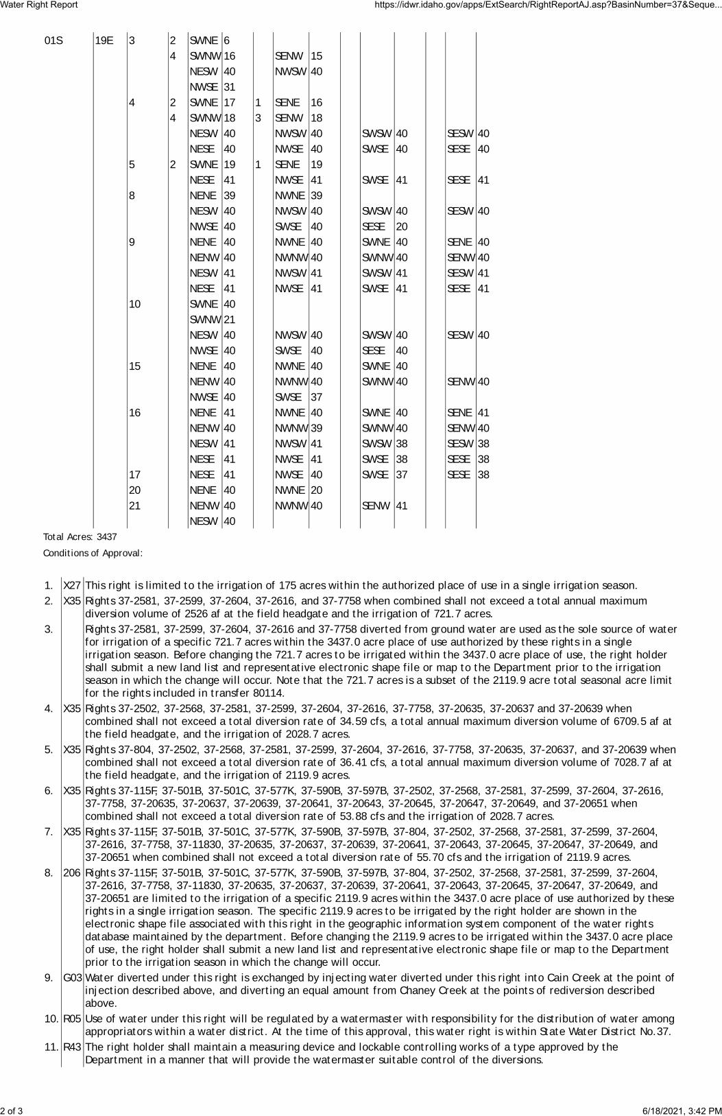
01S 19E 3 2 SWNE 64 SWNW 16 SENW 15
NESW 40 NWSW 40NWSE 31
4 2 SWNE 17 1 SENE 164 SWNW 18 3 SENW 18
NESW 40 NWSW 40 SWSW 40 SESW 40NESE 40 NWSE 40 SWSE 40 SESE 40
5 2 SWNE 19 1 SENE 19NESE 41 NWSE 41 SWSE 41 SESE 41
8 NENE 39 NWNE 39NESW 40 NWSW 40 SWSW 40 SESW 40NWSE 40 SWSE 40 SESE 20
9 NENE 40 NWNE 40 SWNE 40 SENE 40NENW 40 NWNW 40 SWNW 40 SENW 40NESW 41 NWSW 41 SWSW 41 SESW 41NESE 41 NWSE 41 SWSE 41 SESE 41
10 SWNE 40SWNW 21NESW 40 NWSW 40 SWSW 40 SESW 40NWSE 40 SWSE 40 SESE 40
15 NENE 40 NWNE 40 SWNE 40NENW 40 NWNW 40 SWNW 40 SENW 40NWSE 40 SWSE 37
16 NENE 41 NWNE 40 SWNE 40 SENE 41NENW 40 NWNW 39 SWNW 40 SENW 40NESW 41 NWSW 41 SWSW 38 SESW 38NESE 41 NWSE 41 SWSE 38 SESE 38
17 NESE 41 NWSE 40 SWSE 37 SESE 3820 NENE 40 NWNE 2021 NENW 40 NWNW 40 SENW 41
NESW 40Total Acres: 3437
Conditions of Approval:
1. X27 This right is limited to the irrigation of 175 acres within the authorized place of use in a single irrigation season.2. X35 Rights 37-2581, 37-2599, 37-2604, 37-2616, and 37-7758 when combined shall not exceed a total annual maximum
diversion volume of 2526 af at the field headgate and the irrigation of 721.7 acres.3. Rights 37-2581, 37-2599, 37-2604, 37-2616 and 37-7758 diverted from ground water are used as the sole source of water
for irrigation of a specific 721.7 acres within the 3437.0 acre place of use authorized by these rights in a singleirrigation season. Before changing the 721.7 acres to be irrigated within the 3437.0 acre place of use, the right holdershall submit a new land list and representative electronic shape file or map to the Department prior to the irrigationseason in which the change will occur. Note that the 721.7 acres is a subset of the 2119.9 acre total seasonal acre limitfor the rights included in transfer 80114.
4. X35 Rights 37-2502, 37-2568, 37-2581, 37-2599, 37-2604, 37-2616, 37-7758, 37-20635, 37-20637 and 37-20639 whencombined shall not exceed a total diversion rate of 34.59 cfs, a total annual maximum diversion volume of 6709.5 af atthe field headgate, and the irrigation of 2028.7 acres.
5. X35 Rights 37-804, 37-2502, 37-2568, 37-2581, 37-2599, 37-2604, 37-2616, 37-7758, 37-20635, 37-20637, and 37-20639 whencombined shall not exceed a total diversion rate of 36.41 cfs, a total annual maximum diversion volume of 7028.7 af atthe field headgate, and the irrigation of 2119.9 acres.
6. X35 Rights 37-115F, 37-501B, 37-501C, 37-577K, 37-590B, 37-597B, 37-2502, 37-2568, 37-2581, 37-2599, 37-2604, 37-2616,37-7758, 37-20635, 37-20637, 37-20639, 37-20641, 37-20643, 37-20645, 37-20647, 37-20649, and 37-20651 whencombined shall not exceed a total diversion rate of 53.88 cfs and the irrigation of 2028.7 acres.
7. X35 Rights 37-115F, 37-501B, 37-501C, 37-577K, 37-590B, 37-597B, 37-804, 37-2502, 37-2568, 37-2581, 37-2599, 37-2604,37-2616, 37-7758, 37-11830, 37-20635, 37-20637, 37-20639, 37-20641, 37-20643, 37-20645, 37-20647, 37-20649, and37-20651 when combined shall not exceed a total diversion rate of 55.70 cfs and the irrigation of 2119.9 acres.
8. 206 Rights 37-115F, 37-501B, 37-501C, 37-577K, 37-590B, 37-597B, 37-804, 37-2502, 37-2568, 37-2581, 37-2599, 37-2604,37-2616, 37-7758, 37-11830, 37-20635, 37-20637, 37-20639, 37-20641, 37-20643, 37-20645, 37-20647, 37-20649, and37-20651 are limited to the irrigation of a specific 2119.9 acres within the 3437.0 acre place of use authorized by theserights in a single irrigation season. The specific 2119.9 acres to be irrigated by the right holder are shown in theelectronic shape file associated with this right in the geographic information system component of the water rightsdatabase maintained by the department. Before changing the 2119.9 acres to be irrigated within the 3437.0 acre placeof use, the right holder shall submit a new land list and representative electronic shape file or map to the Departmentprior to the irrigation season in which the change will occur.
9. G03 Water diverted under this right is exchanged by injecting water diverted under this right into Cain Creek at the point ofinjection described above, and diverting an equal amount from Chaney Creek at the points of rediversion describedabove.
10. R05 Use of water under this right will be regulated by a watermaster with responsibility for the distribution of water amongappropriators within a water district. At the time of this approval, this water right is within State Water District No.37.
11. R43 The right holder shall maintain a measuring device and lockable controlling works of a type approved by theDepartment in a manner that will provide the watermaster suitable control of the diversions.
Water Right Report https://idwr.idaho.gov/apps/ExtSearch/RightReportAJ.asp?BasinNumber=37&Seque...
2 of 3 6/18/2021, 3:42 PM
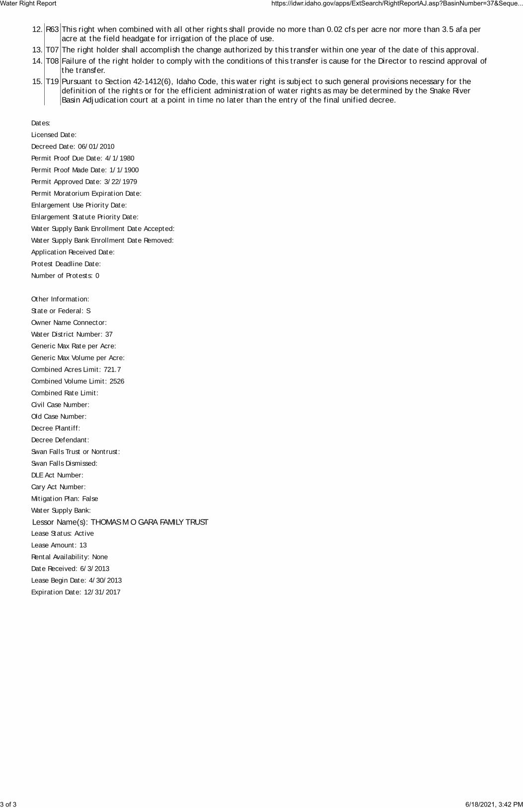
12. R63 This right when combined with all other rights shall provide no more than 0.02 cfs per acre nor more than 3.5 afa peracre at the field headgate for irrigation of the place of use.
13. T07 The right holder shall accomplish the change authorized by this transfer within one year of the date of this approval.14. T08 Failure of the right holder to comply with the conditions of this transfer is cause for the Director to rescind approval of
the transfer.15. T19 Pursuant to Section 42-1412(6), Idaho Code, this water right is subject to such general provisions necessary for the
definition of the rights or for the efficient administration of water rights as may be determined by the Snake RiverBasin Adjudication court at a point in time no later than the entry of the final unified decree.
Dates:
Licensed Date:
Decreed Date: 06/01/2010
Permit Proof Due Date: 4/1/1980
Permit Proof Made Date: 1/1/1900
Permit Approved Date: 3/22/1979
Permit Moratorium Expiration Date:
Enlargement Use Priority Date:
Enlargement Statute Priority Date:
Water Supply Bank Enrollment Date Accepted:
Water Supply Bank Enrollment Date Removed:
Application Received Date:
Protest Deadline Date:
Number of Protests: 0
Other Information:
State or Federal: S
Owner Name Connector:
Water District Number: 37
Generic Max Rate per Acre:
Generic Max Volume per Acre:
Combined Acres Limit: 721.7
Combined Volume Limit: 2526
Combined Rate Limit:
Civil Case Number:
Old Case Number:
Decree Plantiff:
Decree Defendant:
Swan Falls Trust or Nontrust:
Swan Falls Dismissed:
DLE Act Number:
Cary Act Number:
Mitigation Plan: False
Water Supply Bank:
Lessor Name(s): THOMAS M O GARA FAMILY TRUSTLease Status: Active
Lease Amount: 13
Rental Availability: None
Date Received: 6/3/2013
Lease Begin Date: 4/30/2013
Expiration Date: 12/31/2017
Water Right Report https://idwr.idaho.gov/apps/ExtSearch/RightReportAJ.asp?BasinNumber=37&Seque...
3 of 3 6/18/2021, 3:42 PM

I •
. I I O'Gara PPU
~'. POU Irrigation
~=~!:==::~ - DriedAcres
O'Gara - Silver Spring Ranch ~ I
~=-=--=-=-=-~~~-__::_____-~N ~~~ 2020 Proposed Water Bank - Dried Acres · Disclaimers· This map (or data product) is for illustratton
purposes only. It is not .intended to be used for description, conveyance, authontat,ve definition of legal boundary or property title. This 1s not a survey product. Users are ' Allowed Irrigation= 2,119.9 Acres
Dried Acres =304.5 Acres O
o.s Miles
1 encou.raged I~ examiie the documentation or metadata ~ssociat~d with the data on which this map IS based for riformat1on related to its accuracy. currentness, and limitations

Department of
WATER RIGHT REPORT
6/18/2021
IDAHO DEPARTMENT OF WATER RESOURCES
Water Right Report
WATER RIGHT NO. 37-2576
Owner Type Name and AddressCurrent Owner JOHN F STEVENSON
36 HILLSIDE RANCH RDBELLEVUE, ID 83313-51472087884826
Priority Date: 07/13/1955
Basis: Decreed
Status: Active
Source TributaryGROUND WATER
Beneficial Use From To Diversion Rate VolumeIRRIGATION 04/15 10/31 4.69 CFS 840 AFATotal Diversion 4.69 CFS 840 AFA
Location of Point(s) of Diversion:
GROUND WATER SWSENE Sec. 18 Township 01S Range 19E BLAINE CountyIRRIGATION Use:
Acre Limit: 240
Place(s) of use:
Place of Use Legal Description: IRRIGATION BLAINE County
Township Range Section Lot Tract Acres Lot Tract Acres Lot Tract Acres Lot Tract Acres01S 19E 19 NENE 3 SENE 28
NESE 25 SESE 2920 SWNW 6
NWSW 11 SWSW 2827 SWNW 28
NWSW 2628 SWNE 15 SENE 27
NESE 30 NWSE 10 SESE 2229 NWNW 32 SWNW 38 SENW 5.7
NESW 37 NWSW 38NWSE 18
30 NENE 34 SENE 28.133 NENE 2.3
Total Acres: 521.1
Conditions of Approval:
1. C05 Right includes accomplished change in place of use pursuant to Section 42-1425, Idaho Code.2. 065 The right holder shall make full beneficial use of all surface water rights available to the right holder for irrigation of the
lands authorized to be irrigated under this right. The right holder shall limit the diversion of ground water under thisright to those times when the surface water supply is not available or the surface water supply is not reasonablysufficient to irrigate the place of use authorized under this right.
3. E56 The rights listed below are limited to the irrigation of a combined total of 521.1 acres in a single irrigation season.Combined Right Nos.: 37-118, 37-2576, 37-2681, and 37-7644.
IDWR offices are open to the public and following the CDC guidelines for wearing masks and observing social
distancing. For in-person visits, we encourage you to call ahead for an appointment.
Home / Water Rights / Research / Search Water Rights
Water Right Report https://idwr.idaho.gov/apps/ExtSearch/RightReportAJ.asp?BasinNumber=37&Seque...
1 of 2 6/18/2021, 4:42 PM
JDAJ--{Owater Resources ~
X

4. K06 This right is limited to the irrigation of 240 acres within the place of use described above in a single irrigation season.5. 104 If the surface water right appurtenant to the place of use is sold, transferred, leased or used on any other place of use,
this right to divert ground water shall not be used without an approved transfer pursuant to Section 42-222, Idaho Code,or approval of the Department if a transfer is not required.
6. C18 This partial decree is subject to such general provisions necessary for the definition of the rights or for the efficientadministration of the water rights as may be ultimately determined by the Court at a point in time no later than theentry of a final unified decree. Section 42-1412(6), Idaho Code.
Dates:
Licensed Date:
Decreed Date: 05/02/2011
Permit Proof Due Date:
Permit Proof Made Date:
Permit Approved Date:
Permit Moratorium Expiration Date:
Enlargement Use Priority Date:
Enlargement Statute Priority Date:
Water Supply Bank Enrollment Date Accepted:
Water Supply Bank Enrollment Date Removed:
Application Received Date:
Protest Deadline Date:
Number of Protests: 0
Other Information:
State or Federal: S
Owner Name Connector:
Water District Number: 37
Generic Max Rate per Acre:
Generic Max Volume per Acre:
Combined Acres Limit: 521.1
Combined Volume Limit:
Combined Rate Limit:
Civil Case Number:
Old Case Number:
Decree Plantiff:
Decree Defendant:
Swan Falls Trust or Nontrust:
Swan Falls Dismissed:
DLE Act Number:
Cary Act Number:
Mitigation Plan: False
Water Right Report https://idwr.idaho.gov/apps/ExtSearch/RightReportAJ.asp?BasinNumber=37&Seque...
2 of 2 6/18/2021, 4:42 PM

Department of
WATER RIGHT REPORT
6/18/2021
IDAHO DEPARTMENT OF WATER RESOURCES
Water Right Report
WATER RIGHT NO. 37-2681
Owner Type Name and AddressCurrent Owner JOHN F STEVENSON
36 HILLSIDE RANCH RDBELLEVUE, ID 83313-51472087884826
Priority Date: 12/08/1961
Basis: Decreed
Status: Active
Source TributaryGROUND WATER
Beneficial Use From To Diversion Rate VolumeIRRIGATION 04/01 10/31 4.5 CFS 693 AFATotal Diversion 4.5 CFS 693 AFA
Location of Point(s) of Diversion:
GROUND WATER NWNENW Sec. 20 Township 01S Range 19E BLAINE CountyIRRIGATION Use:
Acre Limit: 231
Place(s) of use:
Place of Use Legal Description: IRRIGATION BLAINE County
Township Range Section Lot Tract Acres Lot Tract Acres Lot Tract Acres Lot Tract Acres01S 19E 19 NENE 3 SENE 28
NESE 25 SESE 2920 SWNW 6
NWSW 11 SWSW 2827 SWNW 28
NWSW 2628 SWNE 15 SENE 27
NESE 30 NWSE 10 SESE 2229 NWNW 32 SWNW 38 SENW 5.7
NESW 37 NWSW 38NWSE 18
30 NENE 34 SENE 28.133 NENE 2.3
Total Acres: 521.1
Conditions of Approval:
1. E56 The rights listed below are limited to the irrigation of a combined total of 521.1 acres in a single irrigation season.Combined Right Nos.: 37-118, 37-2576, 37-2681, and 37-7644.
2. K06 This right is limited to the irrigation of 231 acres within the place of use described above in a single irrigation season.3. C05 Right includes accomplished change in place of use pursuant to Section 42-1425, Idaho Code.4. 104 If the surface water right appurtenant to the place of use is sold, transferred, leased or used on any other place of use,
this right to divert ground water shall not be used without an approved transfer pursuant to Section 42-222, Idaho Code,or approval of the Department if a transfer is not required.
IDWR offices are open to the public and following the CDC guidelines for wearing masks and observing social
distancing. For in-person visits, we encourage you to call ahead for an appointment.
Home / Water Rights / Research / Search Water Rights
Water Right Report https://idwr.idaho.gov/apps/ExtSearch/RightReportAJ.asp?BasinNumber=37&Seque...
1 of 2 6/18/2021, 4:42 PM
JDAJ--{Owater Resources ~
X

5. 065 The right holder shall make full beneficial use of all surface water rights available to the right holder for irrigation of thelands authorized to be irrigated under this right. The right holder shall limit the diversion of ground water under thisright to those times when the surface water supply is not available or the surface water supply is not reasonablysufficient to irrigate the place of use authorized under this right.
6. C18 This partial decree is subject to such general provisions necessary for the definition of the rights or for the efficientadministration of the water rights as may be ultimately determined by the Court at a point in time no later than theentry of a final unified decree. Section 42-1412(6), Idaho Code.
Dates:
Licensed Date:
Decreed Date: 01/31/2012
Permit Proof Due Date:
Permit Proof Made Date:
Permit Approved Date:
Permit Moratorium Expiration Date:
Enlargement Use Priority Date:
Enlargement Statute Priority Date:
Water Supply Bank Enrollment Date Accepted:
Water Supply Bank Enrollment Date Removed:
Application Received Date:
Protest Deadline Date:
Number of Protests: 0
Other Information:
State or Federal: S
Owner Name Connector:
Water District Number: 37
Generic Max Rate per Acre:
Generic Max Volume per Acre:
Combined Acres Limit: 521.1
Combined Volume Limit:
Combined Rate Limit:
Civil Case Number:
Old Case Number:
Decree Plantiff:
Decree Defendant:
Swan Falls Trust or Nontrust:
Swan Falls Dismissed:
DLE Act Number:
Cary Act Number:
Mitigation Plan: False
Water Right Report https://idwr.idaho.gov/apps/ExtSearch/RightReportAJ.asp?BasinNumber=37&Seque...
2 of 2 6/18/2021, 4:42 PM
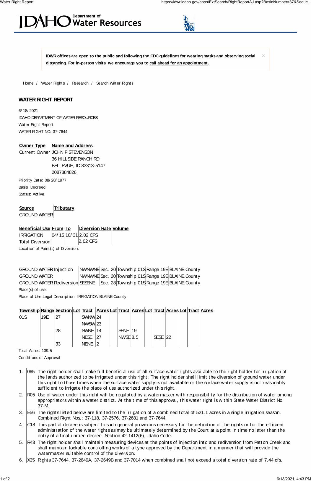
Department of
WATER RIGHT REPORT
6/18/2021
IDAHO DEPARTMENT OF WATER RESOURCES
Water Right Report
WATER RIGHT NO. 37-7644
Owner Type Name and AddressCurrent Owner JOHN F STEVENSON
36 HILLSIDE RANCH RDBELLEVUE, ID 83313-51472087884826
Priority Date: 08/20/1977
Basis: Decreed
Status: Active
Source TributaryGROUND WATER
Beneficial Use From To Diversion Rate VolumeIRRIGATION 04/15 10/31 2.02 CFSTotal Diversion 2.02 CFS
Location of Point(s) of Diversion:
GROUND WATER Injection NWNWNE Sec. 20 Township 01S Range 19E BLAINE CountyGROUND WATER NWNWNE Sec. 20 Township 01S Range 19E BLAINE CountyGROUND WATER Rediversion SESENE Sec. 28 Township 01S Range 19E BLAINE CountyPlace(s) of use:
Place of Use Legal Description: IRRIGATION BLAINE County
Township Range Section Lot Tract Acres Lot Tract Acres Lot Tract Acres Lot Tract Acres01S 19E 27 SWNW 24
NWSW 2328 SWNE 14 SENE 19
NESE 27 NWSE 8.5 SESE 2233 NENE 2
Total Acres: 139.5
Conditions of Approval:
1. 065 The right holder shall make full beneficial use of all surface water rights available to the right holder for irrigation ofthe lands authorized to be irrigated under this right. The right holder shall limit the diversion of ground water underthis right to those times when the surface water supply is not available or the surface water supply is not reasonablysufficient to irrigate the place of use authorized under this right.
2. R05 Use of water under this right will be regulated by a watermaster with responsibility for the distribution of water amongappropriators within a water district. At the time of this approval, this water right is within State Water District No.37-M.
3. E56 The rights listed below are limited to the irrigation of a combined total of 521.1 acres in a single irrigation season.Combined Right Nos.: 37-118, 37-2576, 37-2681 and 37-7644.
4. C18 This partial decree is subject to such general provisions necessary for the definition of the rights or for the efficientadministration of the water rights as may be ultimately determined by the Court at a point in time no later than theentry of a final unified decree. Section 42-1412(6), Idaho Code.
5. R43 The right holder shall maintain measuring devices at the points of injection into and rediversion from Patton Creek andshall maintain lockable controlling works of a type approved by the Department in a manner that will provide thewatermaster suitable control of the diversion.
6. X35 Rights 37-7644, 37-2649A, 37-2649B and 37-7014 when combined shall not exceed a total diversion rate of 7.44 cfs.
IDWR offices are open to the public and following the CDC guidelines for wearing masks and observing social
distancing. For in-person visits, we encourage you to call ahead for an appointment.
Home / Water Rights / Research / Search Water Rights
Water Right Report https://idwr.idaho.gov/apps/ExtSearch/RightReportAJ.asp?BasinNumber=37&Seque...
1 of 2 6/18/2021, 4:43 PM
JDAJ--{Owater Resources ~
X

7. X36 Rights 37-2649A, 37-2649B and 37-7014 are also diverted through the points of diversion described above.8. 104 If the surface water rights appurtenant to the place of use is sold, transferred, leased or used on any other place of
use, this right to divert groundwater shall not be used without an approved transfer pursuant to Section 42-222, IdahoCode, or approval of the Department if a transfer is not required.
9. X56 The portion of Right 37-7644 used for conveyance losses is 0.04 cfs.10. X59 Point of diversion is locally known as The Lucke Well.11. WB7 This right when combined with all other rights shall provide no more than 0.02 cfs per acre nor exceed a combined
annual maximum diversion volume of 488.3 af at the field headgate for the lands above.12. Water diverted under this right is injected into Patton Creek then rediverted from Patton Creek to the place of use.
The amount of water rediverted from Patton Creek under this right shall not exceed 98% of the amount of waterinjected into Patton Creek.
Dates:
Licensed Date:
Decreed Date: 05/31/2011
Permit Proof Due Date: 1/1/1983
Permit Proof Made Date: 2/3/1983
Permit Approved Date: 1/29/1978
Permit Moratorium Expiration Date:
Enlargement Use Priority Date:
Enlargement Statute Priority Date:
Water Supply Bank Enrollment Date Accepted:
Water Supply Bank Enrollment Date Removed:
Application Received Date: 07/18/1977
Protest Deadline Date:
Number of Protests: 0
Other Information:
State or Federal: S
Owner Name Connector:
Water District Number: 37
Generic Max Rate per Acre:
Generic Max Volume per Acre:
Combined Acres Limit: 521.1
Combined Volume Limit:
Combined Rate Limit:
Civil Case Number:
Old Case Number:
Decree Plantiff:
Decree Defendant:
Swan Falls Trust or Nontrust:
Swan Falls Dismissed:
DLE Act Number:
Cary Act Number:
Mitigation Plan: False
Water Right Report https://idwr.idaho.gov/apps/ExtSearch/RightReportAJ.asp?BasinNumber=37&Seque...
2 of 2 6/18/2021, 4:43 PM

!.18
2830
19 2120
16
29
15
22
17
27
31 33 3432
7
14
23
26
8 9
13
25
24
3536
10 1112
The USDA-FSA Aerial Photography Field office asks to becredited in derived products.
State of IdahoDepartment of Water Resources
Water Right37-2576
Map produced on June 21, 2021
IRRIGATION
18E 19E
18E 19E
01S
01
S 01S
01S
!. Point of Diversion
Place Of Use Boundary
Townships
PLS Sections
Quarter Quarters ´
0 0.95 1.90.475 Miles
The map depicts the place of use for the water use listed above and point(s) of diversion of this right as currentlyderived from interpretations of the paper records and is used solely for illustrative purposes. Discrepancies between the computer representation and the permanent document file will be resolved in favor of the actual water right documentsin the water right file.
D D D D

!.
28
2120
29
22
2730
19
3332 3431
17 1618 15
The USDA-FSA Aerial Photography Field office asks to becredited in derived products.
State of IdahoDepartment of Water Resources
Water Right37-2681
Map produced on June 21, 2021
IRRIGATION
19E
01S
!. Point of Diversion
Place Of Use Boundary
Townships
PLS Sections
Quarter Quarters ´
0 0.75 1.50.375 Miles
The map depicts the place of use for the water use listed above and point(s) of diversion of this right as currentlyderived from interpretations of the paper records and is used solely for illustrative purposes. Discrepancies between the computer representation and the permanent document file will be resolved in favor of the actual water right documentsin the water right file.
D D D D
I I I I I I I I I

!.
!.!.
28
2120
29
22
27
33 3432
17 16 15
30
19
31
18
23
26
35
14
The USDA-FSA Aerial Photography Field office asks to becredited in derived products.
State of IdahoDepartment of Water Resources
Water Right37-7644
Map produced on June 21, 2021
IRRIGATION
19E
01S
!. Point of Diversion
Place Of Use Boundary
Townships
PLS Sections
Quarter Quarters ´
0 0.75 1.50.375 Miles
The map depicts the place of use for the water use listed above and point(s) of diversion of this right as currentlyderived from interpretations of the paper records and is used solely for illustrative purposes. Discrepancies between the computer representation and the permanent document file will be resolved in favor of the actual water right documentsin the water right file.
D D D D
I I I I I I I I I

Department of
WATER RIGHT REPORT
6/18/2021
IDAHO DEPARTMENT OF WATER RESOURCES
Water Right Report
WATER RIGHT NO. 37-2649A
Owner Type Name and AddressCurrent Owner JOHN F STEVENSON
36 HILLSIDE RANCH RDBELLEVUE, ID 83313-51472087884826
Priority Date: 01/27/1961
Basis: Decreed
Status: Active
Source TributaryGROUND WATER
Beneficial Use From To Diversion Rate VolumeIRRIGATION 04/01 11/01 4.24 CFS 742 AFATotal Diversion 4.24 CFS 742 AFA
Location of Point(s) of Diversion:
GROUND WATER NWNWNE Sec. 20 Township 01S Range 19E BLAINE CountyIRRIGATION Use:
Acre Limit: 212
Place(s) of use:
Place of Use Legal Description: IRRIGATION BLAINE County
Township Range Section Lot Tract Acres Lot Tract Acres Lot Tract Acres Lot Tract Acres01S 19E 20 NWNE 20 SWNE 40 SENE 40
NESE 40 NWSE 40 SESE 3221 SWNW 40
NWSW 40 SWSW 40 SESW 4028 NENW 25
Total Acres: 397
Conditions of Approval:
1. 065 The right holder shall make full beneficial use of all surface water rights available to the right holder for irrigation ofthe lands authorized to be irrigated under this right. The right holder shall limit the diversion of ground water underthis right to those times when the surface water supply is not available or the surface water supply is not reasonablysufficient to irrigate the place of use authorized under this right.
2. 104 If the surface water rights appurtenant to the place of use is sold, transferred, leased or used on any other place ofuse, this right to divert groundwater shall not be used without an approved transfer pursuant to Section 42-222, IdahoCode, or approval of the Department if a transfer is not required.
3. 067 The right holder shall record the quantity of water diverted and annually report diversions of water and/or otherpertinent hydrologic and system information as required by Section 42-701, Idaho Code.
4. 206 This right is limited to the irrigation of a specific 372.0 acres within the 397.0 acre place of use authorized by this rightin a single irrigation season. The specific 397.0 acres to be irrigated by the right holder are shown in the electronicshape file associated with this right in the geographic information system component of the water rights databasemaintained by the department. Before changing the 372.0 acres to be irrigated within the 397.0 acre place of use, theright holder shall submit a new land list and representative electronic shape file or map to the Department prior to theirrigation season in which the change will occur.
5. F06 The following rights are diverted through point of diversion described above: 37-2649A; 37-2649B; 37-7014 and 37-7644.
IDWR offices are open to the public and following the CDC guidelines for wearing masks and observing social
distancing. For in-person visits, we encourage you to call ahead for an appointment.
Home / Water Rights / Research / Search Water Rights
Water Right Report https://idwr.idaho.gov/apps/ExtSearch/RightReportAJ.asp?BasinNumber=37&Seque...
1 of 2 6/18/2021, 4:44 PM
JDAJ--{Owater Resources ~
X
-----

6. R63 This right when combined with all other rights shall provide no more than 0.02 cfs per acre nor more than 3.5 afa peracre at the field headgate for irrigation of the place of use.
7. X59 Point of diversion is locally known as The Lucke Well.8. X35 Rights 37-7644, 37-2649A, 37-2649B and 37-7014 when combined shall not exceed a total diversion rate of 7.44 cfs.9. T07 The right holder shall accomplish the change authorized by this transfer within one year of the date of this approval.10. T08 Failure of the right holder to comply with the conditions of this transfer is cause for the Director to rescind approval of
the transfer.11. T19 Pursuant to Section 42-1412(6), Idaho Code, this water right is subject to such general provisions necessary for the
definition of the rights or for the efficient administration of water rights as may be determined by the Snake River BasinAdjudication court at a point in time no later than the entry of the final unified decree.
Dates:
Licensed Date:
Decreed Date: 05/31/2011
Enlargement Use Priority Date:
Enlargement Statute Priority Date:
Water Supply Bank Enrollment Date Accepted:
Water Supply Bank Enrollment Date Removed:
Application Received Date:
Protest Deadline Date:
Number of Protests: 0
Other Information:
State or Federal: S
Owner Name Connector:
Water District Number: 37
Generic Max Rate per Acre:
Generic Max Volume per Acre:
Civil Case Number:
Old Case Number:
Decree Plantiff:
Decree Defendant:
Swan Falls Trust or Nontrust:
Swan Falls Dismissed:
DLE Act Number:
Cary Act Number:
Mitigation Plan: False
Water Right Report https://idwr.idaho.gov/apps/ExtSearch/RightReportAJ.asp?BasinNumber=37&Seque...
2 of 2 6/18/2021, 4:44 PM
Department of
WATER RIGHT REPORT
6/18/2021
IDAHO DEPARTMENT OF WATER RESOURCES
Water Right Report
WATER RIGHT NO. 37-2649B
Owner Type Name and AddressCurrent Owner JOHN F STEVENSON
36 HILLSIDE RANCH RDBELLEVUE, ID 83313-51472087884826
Priority Date: 01/27/1961
Basis: Decreed
Status: Active
Water Supply Bank Status: Active
Source TributaryGROUND WATER
Beneficial Use From To Diversion Rate VolumeIRRIGATION 04/01 11/01 3.2 CFS 560 AFATotal Diversion 3.2 CFS 560 AFA
Location of Point(s) of Diversion:
GROUND WATER Injection NWNWNE Sec. 20 Township 01S Range 19E BLAINE CountyGROUND WATER NWNWNE Sec. 20 Township 01S Range 19E BLAINE CountyGROUND WATER Rediversion SESWSW Sec. 21 Township 01S Range 19E BLAINE CountyIRRIGATION Use:
Acre Limit: 160
Place(s) of use:
Place of Use Legal Description: IRRIGATION BLAINE County
Township Range Section Lot Tract Acres Lot Tract Acres Lot Tract Acres Lot Tract Acres01S 19E 20 NWNE 20 SWNE 40 SENE 40
NESE 40 NWSE 40 SESE 3221 SWNW 40
NWSW 40 SWSW 40 SESW 4028 NENW 25
Total Acres: 397
Conditions of Approval:
1. 065 The right holder shall make full beneficial use of all surface water rights available to the right holder for irrigation ofthe lands authorized to be irrigated under this right. The right holder shall limit the diversion of ground water underthis right to those times when the surface water supply is not available or the surface water supply is not reasonablysufficient to irrigate the place of use authorized under this right.
2. 104 If the surface water rights appurtenant to the place of use is sold, transferred, leased or used on any other place ofuse, this right to divert groundwater shall not be used without an approved transfer pursuant to Section 42-222, IdahoCode, or approval of the Department if a transfer is not required.
3. 067 The right holder shall record the quantity of water diverted and annually report diversions of water and/or otherpertinent hydrologic and system information as required by Section 42-701, Idaho Code.
IDWR offices are open to the public and following the CDC guidelines for wearing masks and observing social
distancing. For in-person visits, we encourage you to call ahead for an appointment.
Home / Water Rights / Research / Search Water Rights
Water Right Report https://idwr.idaho.gov/apps/ExtSearch/RightReportAJ.asp?BasinNumber=37&Seque...
1 of 2 6/18/2021, 4:45 PM
JDAJ--{Owater Resources ~
X
-----

4. 206 This right is limited to the irrigation of a specific 372.0 within the 397.0 place of use authorized by this right in a singleirrigation season. The specific 372.0 acres to be irrigated by the right holder are shown in the electronic shape fileassociated with this right in the geographic information system component of the water rights database maintained bythe department. Before changing the 372.0 acres to be irrigated within the 397.0 acre place of use, the right holdershall submit a new land list and representative electronic shape file or map to the Department prior to the irrigationseason in which the change will occur.
5. F06 The following rights are diverted through point of diversion described above: 37-2649A; 37-2649B; 37-7014 and 37-7644.6. R05 Use of water under this right will be regulated by a watermaster with responsibility for the distribution of water among
appropriators within a water district. At the time of this approval, this water right is within State Water District No. 37-M.
7. R43 The right holder shall maintain measuring devices at the points of injection into and rediversion from Patton Creek andshall maintain lockable controlling works of a type approved by the Department in a manner that will provide thewatermaster suitable control of the diversion.
8. R63 This right when combined with all other rights shall provide no more than 0.02 cfs per acre nor more than 3.5 afa peracre at the field headgate for irrigation of the place of use.
9. X35 Rights 37-7644, 37-2649A, 37-2649B and 37-7014 when combined shall not exceed a total diversion rate of 7.44 cfs.10. X56 The portion of Right 37-2649B used for conveyance losses is 2%.11. X59 Point of diversion is locally known as The Lucke Well.12. Water diverted under this right is injected into Patton Creek then rediverted from Patton Creek to the place of use. The
amount of water rediverted from Patton Creek under this right shall not exceed 98% of the amount of water injectedinto Patton Creek.
13. T07 The right holder shall accomplish the change authorized by this transfer within one year of the date of this approval.14. T08 Failure of the right holder to comply with the conditions of this transfer is cause for the Director to rescind approval of
the transfer.15. T19 Pursuant to Section 42-1412(6), Idaho Code, this water right is subject to such general provisions necessary for the
definition of the rights or for the efficient administration of water rights as may be determined by the Snake River BasinAdjudication court at a point in time no later than the entry of the final unified decree.
Dates:
Licensed Date:
Decreed Date: 05/31/2011
Enlargement Use Priority Date:
Enlargement Statute Priority Date:
Water Supply Bank Enrollment Date Accepted:
Water Supply Bank Enrollment Date Removed:
Application Received Date:
Protest Deadline Date:
Number of Protests: 0
Other Information:
State or Federal: S
Owner Name Connector:
Water District Number: 37
Generic Max Rate per Acre:
Generic Max Volume per Acre:
Civil Case Number:
Old Case Number:
Decree Plantiff:
Decree Defendant:
Swan Falls Trust or Nontrust:
Swan Falls Dismissed:
DLE Act Number:
Cary Act Number:
Mitigation Plan: False
Water Supply Bank:
Lessor Name(s): JOHN F STEVENSONLease Status: Active
Lease Amount: 112
Rental Availability: None
Date Received: 4/29/2013
Lease Begin Date: 4/29/2013
Expiration Date: 12/31/2017
Water Right Report https://idwr.idaho.gov/apps/ExtSearch/RightReportAJ.asp?BasinNumber=37&Seque...
2 of 2 6/18/2021, 4:45 PM

!.
2120
2829
17 16
19 22
30 27
18 15
The USDA-FSA Aerial Photography Field office asks to becredited in derived products.
Map produced on June 21, 2021
19E
01S
!. Point of Diversion
Place Of Use Boundary
Townships
PLS Sections
Quarter Quarters ´
0 0.45 0.90.225 Miles
State of IdahoDepartment of Water Resources
Water Right37-2649A - B
IRRIGATION
The map depicts the place of use for the water use listed above and point(s) of diversion of this right as currently derived from interpretations of the paper records and is used solely for illustrative purposes. Discrepancies between the computer representation and the permanent document file will be resolved in favor of the actual water right documents in the water right file.
D D D D

Department of
WATER RIGHT REPORT
6/21/2021
IDAHO DEPARTMENT OF WATER RESOURCES
Water Right Report
WATER RIGHT NO. 37-2493
Owner Type Name and AddressCurrent Owner LAKESIDE INDUSTRIES INC
PO BOX 479BELLEVUE, ID 83313-04792087884389
Original Owner WOOD RIVER RANCH CO INCPO BOX 479BELLEVUE, ID 833132087202141
Priority Date: 12/21/1948
Basis: Decreed
Status: Active
Source TributaryGROUND WATER
Beneficial Use From To Diversion Rate VolumeIRRIGATION 04/15 10/31 2 CFS 350 AFATotal Diversion 2 CFS 350 AFA
Location of Point(s) of Diversion:
GROUND WATER NESESE Sec. 02 Township 01S Range 18E BLAINE CountyGROUND WATER NESESE Sec. 02 Township 01S Range 18E BLAINE CountyPlace(s) of use:
Place of Use Legal Description: IRRIGATION BLAINE County
Township Range Section Lot Tract Acres Lot Tract Acres Lot Tract Acres Lot Tract Acres01S 18E 1 SWSW 24
2 SESW 4SWSE 33 SESE 39
Total Acres: 100
Conditions of Approval:
1. C18 This partial decree is subject to such general provisions necessary for the definition of the rights or for the efficientadministration of the water rights as may be ultimately determined by the Court at a point in time no later than theentry of a final unified decree. Section 42-1412(6), Idaho Code.
2. This right is supplemental to surface water.3. E55 Right Nos. 37-2493, 37-11821, 37-11822 and 37-11823 are limited to the irrigation of a combined total of 100 acres in a
single irrigation season.4. C05 Right includes accomplished change in place of use pursuant to Section 42-1425, Idaho Code.5. C03 Right includes accomplished change in point of diversion pursuant to Section 42-1425, Idaho Code.
Dates:
Licensed Date:
Decreed Date: 09/24/2010
Permit Proof Due Date:
IDWR offices are open to the public and following the CDC guidelines for wearing masks and observing social
distancing. For in-person visits, we encourage you to call ahead for an appointment.
Home / Water Rights / Research / Search Water Rights
Water Right Report https://idwr.idaho.gov/apps/ExtSearch/RightReportAJ.asp?BasinNumber=37&Seque...
1 of 2 6/21/2021, 10:15 AM
JDAJ--{Owater Resources ~
X

Permit Proof Made Date:
Permit Approved Date:
Permit Moratorium Expiration Date:
Enlargement Use Priority Date:
Enlargement Statute Priority Date:
Water Supply Bank Enrollment Date Accepted:
Water Supply Bank Enrollment Date Removed:
Application Received Date:
Protest Deadline Date:
Number of Protests: 0
Other Information:
State or Federal: S
Owner Name Connector:
Water District Number: 37
Generic Max Rate per Acre:
Generic Max Volume per Acre:
Combined Acres Limit: 100
Combined Volume Limit:
Combined Rate Limit:
Civil Case Number:
Old Case Number:
Decree Plantiff:
Decree Defendant:
Swan Falls Trust or Nontrust:
Swan Falls Dismissed:
DLE Act Number:
Cary Act Number:
Mitigation Plan: False
Water Right Report https://idwr.idaho.gov/apps/ExtSearch/RightReportAJ.asp?BasinNumber=37&Seque...
2 of 2 6/21/2021, 10:15 AM

!.!.
2 1
11 12
The USDA-FSA Aerial Photography Field office asks to becredited in derived products.
State of IdahoDepartment of Water Resources
Water Right37-2493
Map produced on June 21, 2021
IRRIGATION
18E
01S
!. Point of Diversion
Place Of Use Boundary
Townships
PLS Sections
Quarter Quarters ´
0 0.2 0.40.1 Miles
The map depicts the place of use for the water use listed above and point(s) of diversion of this right as currentlyderived from interpretations of the paper records and is used solely for illustrative purposes. Discrepancies between the computer representation and the permanent document file will be resolved in favor of the actual water right documentsin the water right file.
D D D D

Department of
WATER RIGHT REPORT
6/17/2021
IDAHO DEPARTMENT OF WATER RESOURCES
Water Right Report
WATER RIGHT NO. 37-8559
Owner Type Name and AddressCurrent Owner LAKESIDE INDUSTRIES INC
PO BOX 479BELLEVUE, ID 83313-04792087884389
Original Owner WOOD RIVER RANCH CO INCPO BOX 479BELLEVUE, ID 833132087202141
Priority Date: 08/17/1989
Basis: License
Status: Active
Source TributaryGROUND WATER
Beneficial Use From To Diversion Rate VolumeIRRIGATION 04/15 10/31 1.15 CFS 202 AFATotal Diversion 1.15 CFS 202 AFA
Location of Point(s) of Diversion:
GROUND WATER NESWSE Sec. 12 Township 01N Range 18E BLAINE CountyPlace(s) of use:
Place of Use Legal Description: IRRIGATION BLAINE County
Township Range Section Lot Tract Acres Lot Tract Acres Lot Tract Acres Lot Tract Acres01N 18E 12 SWSE 24
13 NWNE 33.6Total Acres: 57.6
Conditions of Approval:
1. R05 Use of water under this right will be regulated by a watermaster with responsibility for the distribution of water amongappropriators within a water district. At the time of this approval, this water right is within State Water District No. 37.
2. R43 The right holder shall maintain a measuring device and lockable controlling works of a type approved by the Departmentin a manner that will provide the watermaster suitable control of the diversion(s).
3. R63 This right when combined with all other rights shall provide no more than 0.02 cfs per acre nor more than 3.5 afa peracre at the field headgate for irrigation of the place of use.
4. 933 This right is for the use of trust water, and it is subject to review 20 years after its initial approval (date of permitapproval) to re-evaluate the availability of trust water for the authorized use and to re-evaluate the public interestcriteria for reallocating trust water.
5. 934 When the minimum stream flow water rights in the Snake River at Murphy Gage are not being satisfied, the right holdershall cease diverting water for the consumptive uses authorized by this right.
6. T07 The right holder shall accomplish the change authorized by this transfer within one year of the date of this approval.7. T08 Failure of the right holder to comply with the conditions of this transfer is cause for the Director to rescind approval of
the transfer.8. T19 Pursuant to Section 42-1412(6), Idaho Code, this water right is subject to such general provisions necessary for the
definition of the rights or for the efficient administration of water rights as determined by the Snake River BasinAdjudication court in the final unified decree entered 08/26/2014.
IDWR offices are open to the public and following the CDC guidelines for wearing masks and observing social
distancing. For in-person visits, we encourage you to call ahead for an appointment.
Home / Water Rights / Research / Search Water Rights
Water Right Report https://idwr.idaho.gov/apps/ExtSearch/RightReportAJ.asp?BasinNumber=37&Seque...
1 of 2 6/17/2021, 1:54 PM
JDAJ--{Owater Resources ~
X

Dates:
Licensed Date: 12/19/2011
Decreed Date:
Permit Proof Due Date: 1/1/1991
Permit Proof Made Date: 12/18/1990
Permit Approved Date: 1/2/1990
Permit Moratorium Expiration Date:
Enlargement Use Priority Date:
Enlargement Statute Priority Date:
Water Supply Bank Enrollment Date Accepted:
Water Supply Bank Enrollment Date Removed:
Application Received Date: 08/17/1989
Protest Deadline Date:
Number of Protests: 0
Other Information:
State or Federal:
Owner Name Connector:
Water District Number: 37
Generic Max Rate per Acre: 0.02
Generic Max Volume per Acre: 3.5
Civil Case Number:
Old Case Number:
Decree Plantiff:
Decree Defendant:
Swan Falls Trust or Nontrust:
Swan Falls Dismissed:
DLE Act Number:
Cary Act Number:
Mitigation Plan: False
Water Right Report https://idwr.idaho.gov/apps/ExtSearch/RightReportAJ.asp?BasinNumber=37&Seque...
2 of 2 6/17/2021, 1:54 PM

!.
12
13
7
18
The USDA-FSA Aerial Photography Field office asks to becredited in derived products.
State of IdahoDepartment of Water Resources
Water Right37-8559
Map produced on June 21, 2021
IRRIGATION
18E 19E
18E 19E
01N
01
N 01N
01N
!. Point of Diversion
Place Of Use Boundary
Townships
PLS Sections
Quarter Quarters ´
0 0.15 0.30.075 Miles
The map depicts the place of use for the water use listed above and point(s) of diversion of this right as currentlyderived from interpretations of the paper records and is used solely for illustrative purposes. Discrepancies between the computer representation and the permanent document file will be resolved in favor of the actual water right documentsin the water right file.
D D D D

!.
!.
!.
!.
!.
!.!.
!.
!.
1107
18
19 21
06
20
18
24
13
09
1616
35 36
08
21
15
05
22
17 14
20
12
23
10
19
04
31
17
31 32 33 32 333436
302526 29 282830 29 27
06 05 04 03
25
07
02 01
08 09
28 25 2829262730 3029
10
22
03
13
12
24
15
27
01
25
34
27
1S 19E 1S 20E
1N 19E 1N 20E1N 18E
1S 18E
Wells Proposed to be Pumped for Temporary Transfers
/
0 9,400 18,8004,700 Feet
Based on 2019 NAIP Photography
Legend!. Pumping Wells
Proposed Curtailment Area
Confined Zone Area
D J

Well Log Form 1 4/59 2 M efil?fF~W~nq~fQl
IID DEC 6 1960 I .. W WELL LOG AND REPORT OF THE Depa, anen.t r·
1· .. ..
' u 11 '-i..u.ulidllOA
STATE RECLAMATION· ENGINEER OF IDAHO
~ 034411 Locate well in section
.)
Owner'-----4-l--......,.'---'--..L-l---""""'--_...,,,,;.::__..~__.-<Cb ______ _
NW¼ NE¼
Address------'=-~-+--=---=-_c;,_...:.-..::..h:,_· ..:,:a£=e:..~.....===---------
Well locotiort$£ ¼#:W ¼ Se,= . .;1 Y: , T. ,L N/5'- R. / ,L E/tllr
Size of d'rilled hole~ __ ____.L=-..... "'-() __ t-,.,,. _____________ _ SW¼ SE¼
_________________ Total depth of well /¥0 r7.£. .
Give depth to standing water from the ground V bwater temp. '7"£ °Fahr. /
On "Pumping Test" delivery wrf(};,1.J () O'g.p.m. or ___ ,&.f,s. Drawdown was4'3?'.feet.
Size of pump and motor used to make test /,2, .In-~ ► 70 CJ ~ ~-/-< ,;..e,.£__ ,,.,
Length of time of test __ .,.;,__P __ ___,hoprs _____ __.minutes.
If flowing well, give flow ___ ,c.f.s. or ___ 1g,p.m. and of shut off pressur.._ ________ -_-_______ _
If flowing well, described control work:i.......----------,------,-,-------·-----------/1 (TYPE AND SIZE OF VAJ...VE, ETC, l
w- wm be u,ed lo, ~r~ _,- we;ght of ... ,;ng pe, Uneal foot_--'6"",_· ..... ,'-·-...... __ ...,.,h=::....i..i'-·c_· _
Thickness of cosing ,.;b(;. Casing moterial, __ _,,,_.,, .. JJ/;:~.....,.~..:,L,,.,,"-f_· ________ · _____________ _ /( (STEEL, CONCRETE.,WOOD, ETC.)
Diameter, length and location of casingd_..O,c__ ___ ...:./. ______ y,___..:,:Cl__,~ .......... '--',.____ _______________ _ (CASING 12" IN Dl~OR LESS, GIVE INSIDE DIAMETER:
CASING OVER 12" IN DIAMETER, GIVE OUTSIDE DIAMETER)
CASING RECORD
•Diam. From To Length Remarks-seals, grouting, etc.
Casing Feet Feet
~o r) /",/() /~"t)
-
~--d/4-k~"' -is<~ . Number and size 6'perforations ,;/ u &~· located-4,1 .,,_[---'-7 __ _..feet to { q , ~ "" feet from ground
7.t/ y/
D"te of commencement of well o<-1-~? fl /(I c,
/' I 3 71 ~.., t Date of completion of well___,,.2'"1,,-_· _...-....,~i.______.~'---"'-'. -~___,!Ci,;;":..., .>6
SENIAlt:'.M tA/l'fc
I

From Feet
To Feet
WELL LOG
Type of Material
If more space is required use Sheet No •... 2
WELL DRILLER'S STATEMENT
This well was drtlled under my supervision and the above information is true and correct to the best of n,y know
ledge and belief.
Datec1,______._.K...____.'." ~{)-=cl=__,,_·-_·---·-_ _,, 19~. License No~___,,.,_/_-_S=. '-----_--__
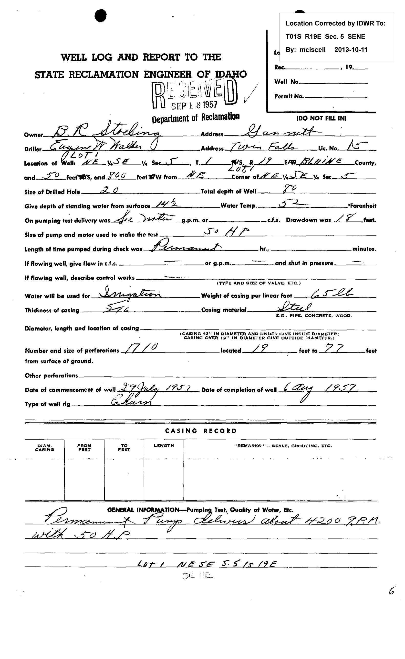
.,
Location Corrected by IDWR To:
T01S R19E Sec.5 SENE
2013-10-11 WELL LOG AND RE:PORT TO THE
By: mciscell Le
Rec--------, 19 __ STATE RECLAMATION ENGINEER OF ID _ _..,,___---
□ I r ' . r -, \ I ! ... . . \/ _: l~ Well No-------~-' i:. . I".'. \ ;::l ~ \ \VJ l l-;, -~:!i \ 6 u \!J Permit No.--------
Sf~P 1 81957 Department of ReclamatiOA ,oo Nor FILL INJ
Owner_.,A~.1..-.!Ll=-:......s;:::~~~~~~~=a~-------Address ,,£/ a:.-:z, ~ . . ··
· -r; ' 5:a--a,_ :::-Driller-k~~~~~-!--_L.~~~::!....-1L _____ Address w ~U)--(-i. CE. .Lie. No... £:±d.. . _
Location of ¼ Sec. t.L , T.-/;.__if./5, -R L! EIW /f:Lt2:_/A(e .County,
and fo
11: .£:c. ¼S IE
feet....,S, onclL() 0 LtJt-/ I
feet •w from ~.,p-_·~e==:........--~•Corner off & ·¼ Je ¼ Sec. s= Size of Drilled Hole __ ....:iJl~'---~=0~~.........-~--------Total depth of Well ___ ..(ol~'----c::> ___________ _
~ -✓ Give depth of standing water from surfaoce /~ ,2_, Water Temp ............... ~---'-'------.__ ---~----~-°Farenheit
On p11mpin9 test delivery was 4,?_ J?-14~=- g.p.m. or _______ c.f.s. Drawdown was Lr feet.
Size of pump and motor usecl to make the test -~---~S-__ cJ_.........../1,...__,._____.._,L ___ ~~------~------
Length of time pumped during check was ~-,,.. ,..,L: .hr.,------~----minutes.
If flowing well, give flow in c.f.s. --------~--or g.p.m. _____ and shut in pressure ____ ~
If flowing well, describe control works ____ ....... -,...;.,,;..;.;.····.;...·-----------------------------
Water will be 11sed for -'-~
Thickness of casing _ • Gr:. -
(TYPE AND SIZE OF VALVE, ETC.)
Weight of casing per linear foot ---ca£z~-J-~-~---~
Casing materia1-----~J2~~,_...:;;:....:::..::~~~---~---E.G., PIPE, CONCRETE, WOOD,
Diameter, length and location of cosing------~---------~----~--------~--(CASING 12" IN DIAMETER AND UNDER GIVE INSIDE DIAMETER:
CASING OVER 12" IN DIAMETER GIVE OUTSIDE DIAMETE:R.)
Number and size of perforations_,.,..L ..... Z,..._/_t/ __________ Jocated_"""''/'----,17'.____~~-feet to 2 Z feet
from surface of ground.
Other perforations--------~~--~--------~---~---~--------
Date of commencement of .wel.i""'"i'-. -r~/-'fo..,,;,...:.~;;.z~.J,----/....;..?.....:;'.f;___,,,jZ'---- Date of completion of well __j~~~L-L2.~~0-:2_L---
Type of well rig ~ - -
CASING RECORD
DIAM, FROM TO LENGTH ''REMARKS'' -- SEALS, GROUTING, ETC. CASING FEET FEET
... ... - ... - .. - - -·--· .. -- . - ... - .. .. . ... -- - - .. . . - .. . . ·-
C)O P.
l.A t: I /ti.ff S:E S: S' L.r l1E

From Feet
/J
__ ;, :>
r1U
To Feet
~.2-
, r tJ
c.:,~; '
WELL LOG
Type of Material
Pd-~~ J/ _ r·· q~r ( /7 -- 71 -~-a~ .. )( - ~ ,,.__,Jl
/ -
Drilling Time
Hrs. Min.
_ J} /If /o ½'-4.-- o/--c::...a. -'-
~
./ c7 /' l-7_..,( ~ _.,. -~ -
p~ JZ.~ ~fJ '- ') / 7 ll )I ~~......, - I ,I / ,~ t./'- _, __ 1_ -<c..-. ' ... - ~ .. 7 ---.
/'1/~ ,,\>. 7 () f7d fi2 - - 7tff~ o- ... JI .12 _£1 d- 1/ 6 . 7 r 1/ I -
-
-------t-------t-----~----------------~~-----+-----1----l----
If more space is required use Sheet No. 2
WELL DRILLER'S STATEMENT
This well was drilled under my jurisdiction and the above information is true and correct to the best of my knowledge and belief ..
License No.. .... ~-~---··············
' .. , ' _,
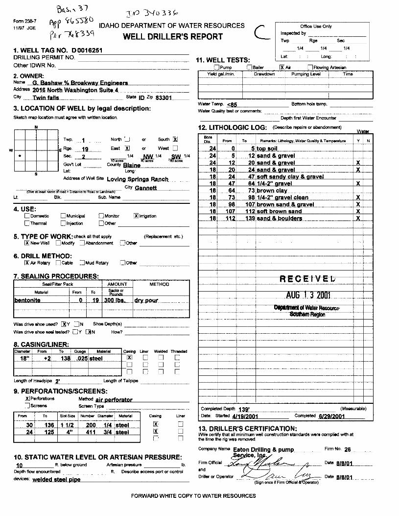
w
:}KJ 3'-fo33/., Form 238-7
11/97 JGE
'oil.~,, Y7
'll'P y(,STIU
\?1 ( N '{3 )c\
IDAHO DEPARTMENT OF WATER RESOURCES
WELL DRILLER'S REPORT c_ Office Use Only
Inspected by _______ _
Twp Rge Sec
114 1. WELL TAG NO. D0016251 DRILLING PERMIT NO. --------------
Other IDWR No.
2.OWNER: Name G Bashaw % Broakway Engineers Addn,ss 2016 North Washington Suite 4 .. ____ _ Ctty Twin falls state 10_ Zip ~6-3~30~1~--
3. LOCATION OF WELL by legal description: Sketch map location must agree with written location.
N
Twp.~~-- North 0 or South 00 E Rge _1~9~- East 00 or West D
• Sec. __ 2-_____ l1facies 1,4 .J!Y!- 1,4 rm 1,4
Gov't Lot County Blaine s Lat: Long:
Address of Well Site _.L,.0,.y,.io,ig,µ;S.,p,._ri._n,.g"'suRa,,..nlJ'c .. hLL. __
- {01-.e at leaat nameofioia + D1stilnce to Road or Landmark) ctty Gannett
Lt. Blk. Sub. Name
□Monitor 00 Irrigation
4. USE: □ Domestic □ Thermal
□ Municipal
Dlnjectioo □Other _________ _
5. TYPE OF WORK: check all that apply (Replacement ate.)
00 New Well D Modify □Abandonment 00ther ______ _
6. DRILL METHOD: 00 Air Rotary O Cable O Mud Rotary □other ______ _
7. SEALING PROCEDURES: SeaVFitter Pack AMOUNT METHOD
Material i From To Sacks or "·"-~
bentonite : 0 19_ JO~ d .. • nour : i
Was drive shoe U98d? ~y ON Shoe Depth(s) ________ _
Was drive shoe seal tested? Ov []N How? ---------8 CASING/LINER· Diameter F,om To Guoge Mattrial C asing Liner Welded Threadad
18" +2 138 .025 steel 00 □ □ □ □ □ □ □ □ □ □ □
Length of Headpipe ~•-----~Length of Tailpipe ______ _
9. PERFORATIONS/SCREENS: 00 Perforations
□ Screens
Frnm To
30 136 -24 125
Slot Size
11/2 4"
Method air perforator Screen Typa
Number Diameter Material
200 1/4 steel 411 3/4 steel
Casing Liner
00 □ 00 □ □ □
10. STATIC WATER LEVEL OR ARTESIAN PRESSURE: 1 O ft. below ground Artesian pressure _____ lb.
Depth flow encountered _______ ft. Describe eccess port or control
devK:es: welded steel pipe
11. WELL TESTS: Lat:
□Pump □ Bailer [&]Air Yleld gal./min. Drawdown
1/4 1/4
Long:
D Flowing Artesian
Pumping Level Time
Water Temp. _<-8-5~------- Bottom hole temp. _____ _ Water Quality test or comments: ______________ _
___________ Depth first Water Encounter ____ _
12 LITHOLOGIC LOG· (Describe repairs or abendonment) '" ter
Bore Dia. F,om To Remarks: Lithology, Watur Quality & Temperature y N
24 0 -~ lt!m..soil 24 5 12 sand & aravel
i-----·· 24 12 20 sand & gravel X 18 _.2l)_ _-24 sand & aravel X 18 24 47 I soft s•n"u clav & nravel 18 47 64 1/4-2" aravel X 18 64 73 brown clav 18 73 98 1/4-2" gravel clean X 18 98 107 brown sand & aravel X 18 107 112 soft brown sand X
1--____jJ. 112 139 sand B, bouldell!_ )(_ ---
' I
... I ncu1.1v ... 1.1
I
I AUb 1 :i /11111 I
·- Aasoun:e• I ·nogmn
' '
: I
f-•-··- 1----· ' I I ~-
r·
Compleled Depth 1 'lll'll1 (Measurable)
Date: Started 411912001 Completed 6/29/2001
13. DRILLER'S CERTIFICATION: IM/e certify that all minimum well construction standards were complied with at 1he time the rig was removed.
FORWARD WHITE COPY TO WATER RESOURCES
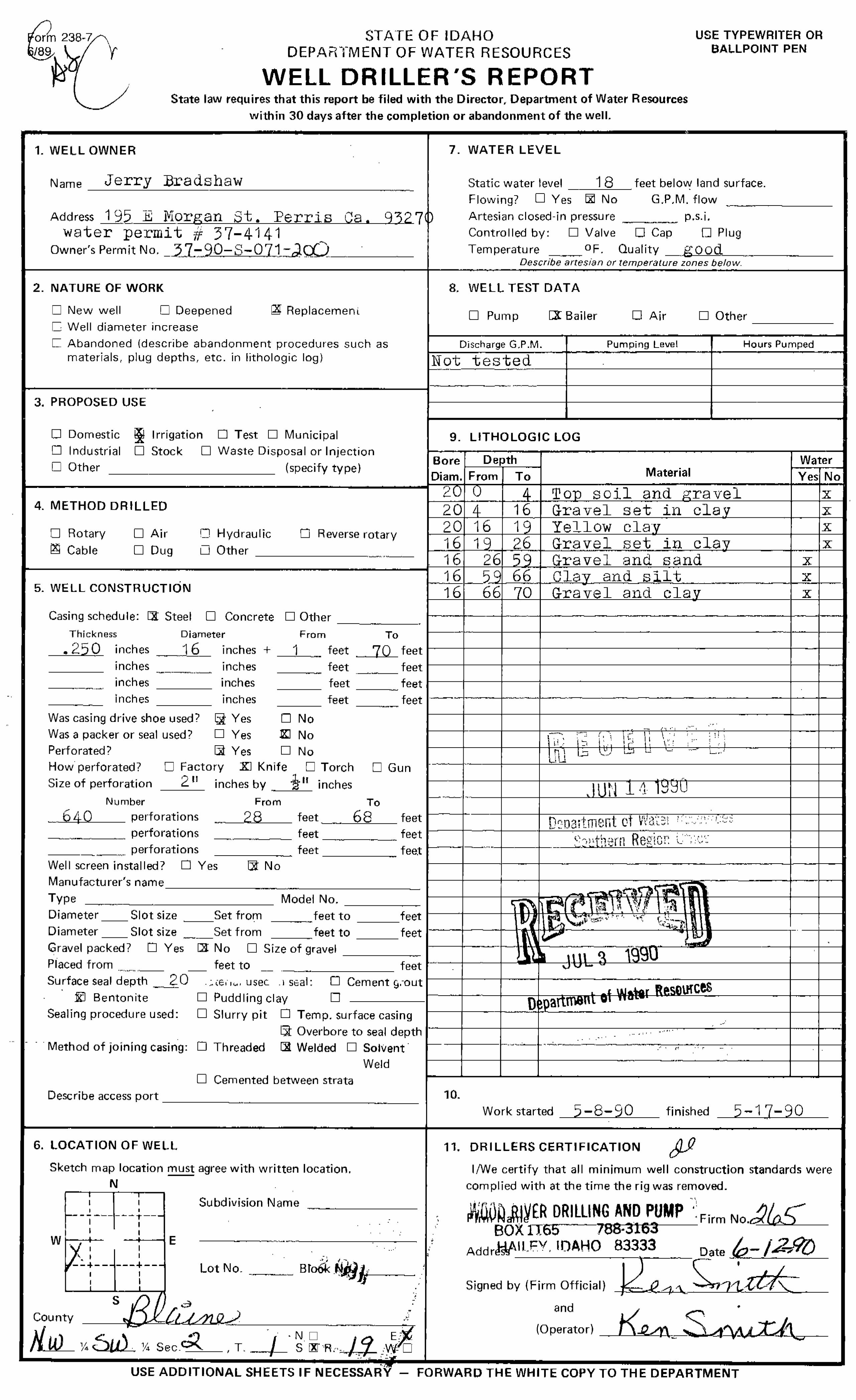
rm 238- S'TATE OF IDAHO DEPAr(_f.MENT OF WATER RESOURCES
USE TYPEWRITER OR BALLPOINT PEN
WELL DRILLER'S REPORT State law requires that this report be filed with the Director, Department of Water Resources
within 30 days after the completion or abandonment of the well.
1. WELL OWNER 7. WATER LEVEL
Name Jerry Bradshaw -----'=-----------------------·- Static water level 1 8 feet below land surface.
•
Flowing? D Yes lxl No G.P.M. flow
Address 195 .. E Jvlor.•gan St. Perr·is Ca. 9327) Artesian closed-in pressure ---·-- p,s.i. Controlled by: □ Valve □ Cap □ Plug water permit# 37-4141
Owner's Permit No. _)_7_:::-_90-S-07_1_:-~Q..) ____ -___ _
2. NATURE OF WORK
D New well □ Deepened Q\f Replacemer1l
C, Well diameter increase
C Abandoned (describe abandonment procedures such as materials, plug depths, etc. in lithologic log)
Temperature _, ___ °F. Quality __ good ·--------Describe arfesian or ternperature zones below.
8. WELL TEST DATA
□ Pu1np [][ Bailer □ Air □ Other ------
Discharge G.P .M. Pumping Level Hours Pumped
Not tested ~·--~-.. , . .,~-----+-----------+---------
1-----------------------------1~~- -"----~·" ,-~,--~---t----------------11----------
3. PROPOSED USE ,
□ Domestic i Irrigation D Test □ Municipal
□ I nclustrial
□ Other
□ Stock □ Waste Disposal or Injection
(specify type)
4. METHOD DRILLED
□ Rotary
~ Cable □ Air
□ Dug
•
5. WELL CONSTRUCTION
r::J Hydraulic
LJ Other
□ Reverse rotary
-------- -~~~"'""~-
9. LITHOLOGIC LOG
Bore Depth Water Di am. 1-F_r_o_m--'-r--T-0---.. Mater i a I Yes No
2, ', A Ton soil and ;:,-ravel x l----l---·f--·.1...,~~~~=:c......::=~=-='-'c.=.cc=-------1------+'"-----20 e 16 Gravel set i11 clav X
20 16 1c Yellow clav x 1 6 1 c 2 6 G,r ..,~a~v~e,,_,l.,___,s"'-e::::_t..':!__=i~n'---"c""l"-"'aC..J1 v'-----+----l""'x'----1---'--'::+---'--"'-::t-::-"':--+---' ,,_ 16 26 i:;c Gravel and sand x
Casing schedule: Dl Steel □ Concrete □ Otl1er 1---•-- ·--·--+"·-·--···-+-····-·-·----·--·---------+--·-•-·--Thickness Diameter
.250 inches 16 inches +
-----
inches
inches
inches
~~ .. - -
Was casing drive shoe used 1
Was a packer or seal used 1
Perforated 7
inches
inches
inches
~ Yes
□ Yes
Ba Yes
1
□ m □
----·---· From To
feet 70 feet -- -feet feet ---feet feet ·-feet feet -"·-
No
No
No How perforated?
Size of perforation
D Factory Xl Knife □ Torch □ Gun 2 11 inches by ½ 11 inches
Nl1mber perforations
From
___ _._2,,.,8'-----_,._ .. , ______ ,. perforations
___ ,.,_ , .... perforations
Well screen installed? 0 Yes Ba No
feet ---feet --feet
To
68 feet
feet ""
fee:t
1-----1-----1------+-----------------f---+-"'~·
'-"'
,., ' .. ,. I., ,·' ,, ... < '
- ·-l----+--+-------,-,--;-;,-;---t---,----,n"ict'n'"t-------+--+--t .. 1 i\ \..'-
• l ( ~ ..... '_t" I .... "-- ~. ~-,~~- ""'·--+----+--~~~-------------+--+-
--+---1-----t--------------------+--+--
Manufacturer's name ,-,--1-,------:--=:::-:::;:;~~= ---.. -·---.--=--=--=--=--=--=--=--=-====-··-=--M--o-d-el_N_o_. -=--=--=--=--=--=--------= .--,--t.~ .. ~r.;;;; -,,'7~ ~-w-~ Type
Diameter __ Slot size __ Set from --.. feet to ___ feet 1---+-----t----t- ~ ,~ ,,,.,;,,,. ,, ... •·,;; \ ... "--.., __,.,. , .... - - ..
feet to feet ----Diameter Slot size ____ Set from
Gravel packed? D Yes IX No D Size of gravel ------1---,-----r-··i ·
feet to feet ... •--+--·-+------·------ . Placed from .,., .. ,.,., ·--Surf ace seal depth _ 2 0 ._;,1o,,c., usec .1 s1cal: 0 Cement £!.-out
•
ID Bentonite □ Puddling clay □
Sealing procedure used: D Slurry pit O Temp. surface casing
· · · Method of joining casing: D Threaded 5t Overbore to seal depth ·-
cg Welded □ Solvent· . . . . "'
•• • I ' •
\HCts
.. -· " .- . ' .
-+----1---.,~--~-t--~~~"~~-·-·--·-~-~~ ~..,., ______ _,__ _ _,___ .·· • ri · · r
Weld +----+---+------,..---------···----·-·----1------1---
D Cemented between strata Describe access port -----··---------·-··---
6. LOCATION OF WELL
Sketch map location must agree with written location.
I I
N I I
I ' i....- - - -~- --~ -r---
1 I I I W . ___...__, E
~:l ______ 1 __ _ I I
i ! s ,/) ' 0
County ---------"
Subdivision Name -----------
' ...
•• -~ -I ••
Lot No.--··-__ Brook r,JA}}j-.-1-·· ---.' • . ,
•
• ' •
10. Work started 5-8-90 finished _.,,,_5_-_1'-7,_-----'""-9=0 __
11. DRILLERS CERTIFICATION
I/We certify that all minimum well construction standards were
complied with at the time the rig was removed. .. '
WrUO~aR1~£R DRILLING AND PUMP ·~ Firm No.~~5--BOX lJ.65 788-3163
AddrJ;V\ll"FY. IOAHO 83333 D3Jte -~- /.::...7.f?{)
"- ' L Signed by (Firm Official) 1
.:' ,e 4 .'.\~ -,J"t-:t-tr"-and
(Operator) --·
• -
-NM"'---- ¼Su). ¼ Sec.C_;z,.~, T. --~t--. ~ ~. R,·aJ:t- ,;:; ci ,_......, _____________________ _ USE ADDITIONAL SHEETS IF NECESSARY - FORWARD THE WHITE COPY TO THE DEPARTMENT

C STAT~~-~IOAHO
DEPARTMENT OF WATER RESOURCES USE TYPEWRITER OR
BALLPOINT PEN
WELL DRILLER'S REPORT State law requires that this report be filed with the Director. Department of Water Resources
within 30 days after the c;ompletion or abandonment of the well.
1. WELL OWNER 7. WATER LEVEL
Name /149, boo J.1 'v~s f.,,cjc 6 -kNc., Static water level ~, feet below land surface.
Address l'.6 Rat 0'8'~ .p/{;,.abtt. .L/ok,, ,Bf~ Flowing? D Yes rs! No G.P.M. flow
37-o/L- s-oos ... ;:JOO Artesian closed-in pressure p.s.i. Drilling Permit No. Controlled by: D Valve D Cap 0 Plug
Water Right Permit No. tJ. a.z- o 2 "li'-1 Temperature OF_ Quality C l eo. r - c'.x c.d \ e 1ec \--Describe artesian_or temperature zones below.
2. NATURE OF WORK 8. WELL TEST DATA
ISi New well D Deepened it(Replacement □ Well diameter increase
ISi Pump D Bailer □ Air D Other
□ Abandoned (describe abandonment procedures such as Discharge G.P,M. Pumping Level Hours Pumped materials, plug depths, etc. in lithologic log) 5460 ,.'.;1 / I
3. PROPOSED USE
D Domestic CS, Irrigation D Test 0 Municipal 9. LITHOLOGIC LOG 8'7~~:t1. D Industrial 0 Stock D Waste Disposal or Injection
Bore Depth Water D Other (specify type)
Diam. From To Material Yes No
~· n' ,;;;.' il).o ...,,,j I x· 4. METHOD DRILLED ;~• 7' r:;,.,.:,, vlll .--. ... ..J c;;, ___ ., .. e,,..," )(
7' 9' r.,.,.,., .I ..::; ...... A ' x D Rotary D Air D Hydraulic D Reverse rotary 9' ~-,, ~ ..... ~ ..._,.,,.,.,.l • C..lr..,, x·
!SJ Cable 0 Dug 0 Other .,2 I ' :15. ,,,r, I '.,.,.,L. -<.,·.;,.,, r-..,_;, ,,,. ( X :+S' J./0 I r-....,..,.,, ..,,""'"'" f' In., 'i
5. WELL CONSTRUCTION 'iO' 55' I,.,.,"'.._ RJn,.f f..,,,,,,.! ..! R,. .. ,.,,. r1,..,., }(
55' tn5' c;,..,1,d PJ11"1:' I ,1110.. ( )(
Casing schedule: ~ Steel D Concrete D Other G,5' 75' R.,,..J. C. l ,vA@i's ',(_
Thickness Diameter From To 75' /'II)' Rrto1 8/a,..lr 1-.,,-,, ✓,,., Q.r"PVO,._C'p ,./. )( .aso inches ::io inches + I feet -22.._ feet 11./o' M,::J' VPri, 1.,,,., ,.,.l ..,,,..ud P..-. ""'" 1+ >( .~50 So ---22._ inches Ua inches feet feet 11.,.,:,' I '711' Rrnk'°" Rlac.K t--o..V'n -f'n,,i V\.l'.l- )(
inches inches feet feet -----inches inches feet feet --
Was casing drive shoe used? D Yes D No Was a packer or seal used? D Yes D No ------Perforated? l'SI Yes D No How perforated? D Factory ~ Knife D Torch D Gun Size of perforation Va inches by ___,'.2__ inches
Number From To /(bO perforations 50 feet 70 feet
perforations .. feet feet perforations feet feet
Well screen installed? D Yes l'SI No Manufacturer's name Type Model No. Diameter Slot size Set from feet to feet -- -- ---Diameter --Slot size --Set from ---feet to feet ---Gravel packed? D Yes l'SI No D Size of gravel Placed from feet to feet -
r.!/~: '.'°/~~ ""'-· Surface seal depth ~ Material used in seal: D Cement grout ' ll'.~' '-~ •; i"V' ,r.ti,u •• ,.,.,, J
!SJ Bentonite l'SI Puddling clay D - ·•.llfJ·I C II . Sealing procedure used: D Slurry pit l'SI Temp. surface casing )r:-n - i
D Overbore to seal depth -v 4 19Q') Method of joining casing: D Threaded l'SI Welded D Solvent - I
Weld I □ Cemented between strata ,
Describe access port {)(J.t!:1 D b.a,s.e. "-'l-0. l'-1-J.Q
.• ~--- ..... ,_ ""ri:,
Feh /J:brch ;;;J.7-9;J. T 1 Woi't("l;tart..d finished "L'r,. • .,;_
_.,,
6. LOCATION OF WELL 11. DRILLERS CERTIFICATION
Sketch map location !!!.!:!!! agree with written location. I/We certify that all minimum well construction standards were N complied with at the time the rig was removed.
~-i--+--t--- Subdivision Name Firm Name rv\~.r:bl'l'~ Well :Se<'vi'c.e_ Firm No. 1../7_8_
w ~ I E
·--~--+--f--· Address +?6 Bo;:.(; '1".J. 3 -Ke.ilal.!."S Date J./- JI- 92 Lot No. Block No,
Signed by (Firm Officiala~S7'~ • - / --I ! ' s
and ,4~ /- -- -~ County 'i:s\g:v\~ (Operator) . . ~~ _,,,. · - · ·. . 1'$ ND E IZJ
\ N'W ¼ 6W ¼ Sec.~, T . ...:f:5::_ S lZI R . ....2a_ W D . / ,.__,. ~
..
USE ADDITIONAL SHEETS IF NECESSARY - FORWARD THE WHITE COPY TO THE DEPARTMENT

Well Log Form 1 • -4/59 2 M ~.-1"!;1.,~_:~ ··~·· .,., ... __ .,.~ ..,1··--"'
WELL LOG AND REPORT OF THE
i. D ~fFnl\ll!efm [ffi ~\\J JI \VJ le: ID J APR 4 1961 ,_,
STATE RECLAMATION ENGmEER OF IDAHOOepartment of keclamation
,, W? County ~.. 03456(~ 1~ ~&d-a~ e. Locate well In section
Permit No
Owner
Addres.._s ------,1~~,<"-"""', -41"""""'_h--''"---=----.;-~~-\'~,,1~·~=.v~---
Driller• ___ ~u~~~~::::l..,&.._~/~/r-~Y:..:...~..:~=-=---==-=:.:..._-------
~'----¼££ ¼ Sec-d O , T, / =-,«s, R.,_,{tJ E/e
Size of d'rilled hole /£ ~ _________________ Total depth of well /7 1
Give depth to standing water from the groun,-1/¥:i Water temp~~,,_9' __ °Fahr .
.:1,700 -~ On "Pumping Test" delivery wa....._. __ g,.p.m. or ___ ,e:,f.s. Drawdown was ..) feet.
NW¼ NE¼
SW¼ SE¼
Size of pump and motor used to make tes•L-----'-/_,,2""'--:?1-",-'--J!.~'-""""'--"-=------'------",),.._...s..C.,_)-'0::....,_~..:..._· "--'°--------Length of time of fed,...__ __ 7'--_ __,ho"rs~-----'minutes,
If flowing well, give flow_-__ - .... c.f.s. or~ _ _,g.p.m. and of shut off pressur.._ ____________ _
If _flowing well, describecl~c trol wo. lr'L ~ ---.. .. /.J · · ~ (TYPE AND SIZE OF VAi.VE, ETC. I
Water will be used for .ec:ie?,--.,'{: Weight of casing per lineal folllt._, __ £-,c..._,:, _____ _ I
Thickness of casing ~ Casing material ._.,,~ ,1
/ (STEEL, CONCRETE. WO~D, C.)
Diameter, length and location of casing 9¥2 -0-- / t' ~ (CASINefa" IN DIAMETER OR LESS, .GIVE INS1DEDAMETER;
CASING OVER 12" IN DIAMETER, QI.VE OUTSIDE DIAMETER)
'Diam. Casi,ng
From Feet
c) - ·- __ ·...:' . ....:· --- -- --= =-
To Feet
Length
CASING RECORD
Remarks-seals, grouting, etc.
Number and size of perforation-s __ :2i_~\"--""~:..u..· """""""""'--<--locate,..__ _____ ,feet tu.o ____ --Jfeet from ground
D11te of commencement of well "t l cC::/ -, ,/ }_ ,.,__,. /9C::/
o<-- Ow / r Date of completion of wel,_I __ A_--'Y __ ,.._P?_,___~___:_c__,L _ __;__

From .. Feet
To .Feet
• WELL LOG
Type of Material
If more space Is required use Sheet No .. ,2
WELL DRILLER'S STATEMENT
This well was driUed under my supervision and the above Information is true and correct to the best of ~)~_know
ledge and belief.
2 u~ · ~/' Dateu.d _____ ...,._c....:....:........::....::::....L.--,, 19_· -· 7
License No _ __,./'--=..s=------

STATE OF IDAHO DEPARTMENT OF WATER RESOURCES
USE TYPEWRITER OR BALLPOINT PEN
WELL DRILLER'S REPORT 3 S~~11aw requires that this report be filed with the Director, Department of Water Resources
within 30 days after the completion or abandonment of the well . - .it '. '.L~ l-1"1,1· r,.,.., "''°'''"',..n.~'-'. t•,,,. - - . . .. ,.,,
,. WELL OWNER\ (~i:~i,~:i Cr,,ce 7. WATER LEVEL
Name _J}Quble R Ranch cio Darryl Smith Static water level 17 feet below land surface. Flowing? D Yes CXI No G.P.M. flow
Address ,,Picabo, Idat}.9 833~8 Artesian closed-in pressure ________ p.s.i. Controlled by: □ Valve □ Cap □ Plug
Owner's Permit No. .27-7221 Temperature of. Quality Goog --~·-·-Descr1be artesian or temperature zones below.
2. NATURE OF WORK 8. WELL TEST DATA
□ New well IX Deepened □ Replacement □ Pump □ Bailer □ Air D Other
□ Abandoned (describe abandonment procedures such as materials. plug depths, etc. in lithologic log) Discharge G.P.M. Pumping Level Hours Pumped
---nu-••- -•
3. PROPOSED USE ,.,.--~
□ Domestic ~ Irrigation □ Test □ Municipal 9. LITHOLOGIC LOG ~6751. □ Industrial □ Stock □ Waste Disposal or Injection
Deoth Water 0 Other (specify type) Bore
-, , .. ... Diam. From To Material Yes No
16 ?l, Sfi l,l'a"t"ri a,..~,, hJeic,al t y 4. METHOD DRILLED 16 86 97 Cinrill'lrs X
I]: Rotary □ Air □ Hydraulic □ Reverse rotary lb 97 100 Firm brown basalt X 16 100 106 .... . brown ha CUI, t. :x. D Cable □ Dug D Other ~--- 16 106 , ,~ Firm gra.v ha.alt X H, 12~ '" --132- r.i11dP-ri:: y
5. WELL CONSTRUCTION 16 114 _ _ J.,35_ Jinn brown basalt X Casing schedule: D Steel □ Concrete D Other
16 135 __ --~~7 Cinders X
Thickness Diameter From To
inches inches + feet feet ~--···· ------- ----- ----- -,--
inches inches feet feet --~---- -~---~·-··,---- --- ----inches inches feet feet ~----- ---inches inches ·feet feet ,,·-~·-- ----
Was casing drive shoe used? D Yes :lJ No t.J No
•a••-~•-• ---Was a packer or seal used? □ Yes I\ • I ::,rl5'1[\\// 1a..- I Perforated? D Yes Q No ·----
~! ~·-- - '~ 'di ! ';?"" l □ D Torch ···- . ' ~ .. --
How perforated? Factory D Knife i;, ',,,.-- ·-.:~ ! i Size of perforation inches by ___ inches ---
~.~ "
n 4,_,.,,"7 um' Number From To -~---~ FEB tu 1.:iut
perforations feet feet -~-~-~ ~ -- --·-_______ , _____ perforations feet feet
perforations feet feet ~-,~ -, ::Jfepartment of Water~:>UUII,~;) --u••
Wei I screen installed? D Yes XJ No t----- --
---Manufacturer's name Type Model No. - --. ··t'r r::i.-J •-1~ 'l ''l." I: Diameter Slot size Set from >----- -
! l,, ... • . : ·: '
-- ~-- ----feet to ---feet ,: "' i ,-,_...,.. - ... V l 1: Diameter _· _ Slot size Set from feet to feet 3 .... ... -- --··· --- ... Gravel packed? □ Yes XJ No □ Size of gravel EEB 2 .1QlD Placed from feet to feet --· Surface seal depth--·--· Material used in seal: D Cement grout 1----------~---
De,;:,a:,r•k r,t u, • I ,, D Bentonite □ Puddling clay □ i--------.-~-·
F:r.sti;m 1 --!·•,,_ .. /'••r:, ·' Sealing procedure used: D Slurry pit D Temp. surface casing
D Overbore to seal depth .,
Method of joining casing: D Threaded D Welded D Solvent Weld
D Cemented between strata Describe access port ____ 10.
Work started 8L1LS6 finished 8L6L86
6. LOCATION OF WELL Jll1fllllV 1 ,. DRILLERS CERTIFICATION
Sketch map location ~ agree with written location. I/We certify that all minimum well construction standards were N complied with at the time the rig was removed.
____ 1-~+--t--- Subdivision Name Firm Name__jngrew Well Orfl]jnffirm No. 5 I I I I
w I--+- E .. Address ..12.6.8 E. 17th Street Date 8/14/86 I I
I I
---+--- ---+--- Lot No. Block No. ldahoFall~ho 8~ I I I I
s Signed by (Firm Official ~~4'1,,,,11.1)
and i9c County Blaine (Operator) ·W ;:ef~
_____NE- ¼ __IDt_ ¼ Sec. JO . T . l DI/S, R. 2U _ E/111.
USE ADDITIONAL SHEETS IF NECESSARY - FORWARD THE WHITE COPY TO THE DEPARTMENT
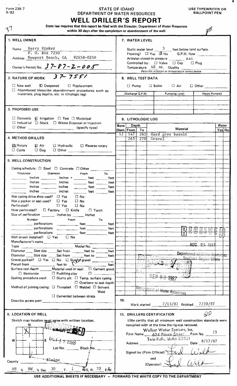
Form 238-7 9/82
STATE OF IDAHO DEPARTMENT OF WATER RESOURCES
USE TYPEWRITER OR BALLPOINT PEN
WELL DRILLER'S REPORT State law requires that this report be filed with the Director, Department of Water Resources
within 30 days after the completion or abandonment of the well.
1. WELL OWNER
Narne_~H~a_r_r~y'--=R_i_n_k~e~r~=---------------P. 0. Box 7250
Address Newport Beach, CA 92658-0250
Owner's Permit No. J 7- f 7 - z_ - /) t'J ._r
2. NATURE OF WORK
□ New well Kl Deepened □ Replacement D Abandoned (describe abandonment procedures such as
materials, plug depths, etc. in lithologic log)
3. PROPOSED USE
D Domestic £l Irrigation D Test D Municipal D Industrial O Stock D Waste Disposal or Injection D Other ___________ (specify type)
4. METHOD DRILLED
Kk.Rotary D Cable
ID Air □ Dug
5. WELL CONSTRUCTION
□ Hydraulic □ Reverse rotary D Other _________ _
Casing schedule: D Steel D Concrete □ Other _____ _
7. WATER LEVEL
Static water level 3 feet below land surface. Flowing? D Yes ~ No G.P.M. flow Artesian closed-in pressure ___ _ p.s.i. Controlled by: D Valve D Cap 0 Plug Temperature 48 OF. Quality __________ _
Describe artesian or temperature zones below.
8. WELL TEST DATA
□ Pump □ Bailer □ Air
Discharge G.P.M. Pumping Level
9. LITHOLOGIC LOG
Bore 1--....;D'-e"-'!1..-'t:;:.;h_.., Diam. From To Material
lZ 147 265 Hard grey basalt 265 270 Gravel
□ Other -----Hours Pumped
Water Yes No
Thickness Diameter From To 1----+----le----+------------------+--+---I inches ___ _ inches + ___ feet ___ feet inches ___ _ inches
inches inches
_ __ feet ___ feet 1----+----le----+------------------+--+----t inches ___ _ ___ feet ___ feet 1----+----le-----J------------------+--+----t
inches ___ _ ___ feet feet 1----+----le---..-+------------------+--+--t
Was casing drive shoe used? □ Yes □ No Was a packer or seal used? □ Yes □ No Perforated? D Yes □ No How perforated? D Factory □ Knife D Torch Size of perforation inches by ___ inches
From To Number _____ perforations ______ perforations
_____ feet _____ feet _ _ _
---- feet feet ~-----l------l------l--------F;,o~JIRl:;"1"a"r::!\-~1sr-1. Irr-I 7"T11-,-,-,7--.l:::i..;-s --,.!..i; ~cc--1,
______ perforations _____ feet feet LI LI c..., 1.,;.,, D u u ::1 i ;_ i Well screen installed? □ Yes D No 1-----+------J----+-------------"='---------t-----i~i::'.:b'----t
Manufacturer's name_________________ A 11/' ,., :: 19
2"1 Type ____________ Model No. _____ 1---+------J----+----------~~---,;;.~_,_..,,.'-f--ft----t---1
Sealing procedure used: □ Slurry pit D Temp. surface casing -• v u 1:10! D Overbore to seal depth
Method of joining casing: □ Threaded D Welded D Solvent 1----+-----11-Ll,.,_e_p_;:;.--l•··--r;--;"-_,,-,-,--:--i-r.:,--_------------+--+---t
Weld •atr:1 rrnsources □ Cemented between strata
Describe access port ________________ _
6. LOCATION OF WELL
10. Work started 7 /13/87 finished 7 /20/87
11. DRILLERS CERTIFICATION
I/We certify that all minimum well construction standards were complied with at the time the rig was removed.
Walket Water Systems, lne. 15 Firm Name 624 Pierce Stro2cr Firm No. ____ _
Twin f...:i!l:,, Idaho E33Ci 1 8117187 Address •·- Date ______ _
~ /l L' !:_J'),t JJ Signed by (Firm Official)~_·:,.,• +<'-"'.,--4a~µ'){,___--1_,..,~""-,.,_ __ :itX_..,._""'J"-----L__ ___ _
(Op:::wl £,; [<)c[:._/<'_-_-----_-___ _
USE ADDITIONAL SHEETS IF NECESSARY - FORWARD THE WHITE COPY TO THE DEPARTMENT

Aell Log .B'orm l 3M
SUBMIT WITHIN 30 DAYS AFTER COkPLE'I'IuN OF WELL: SEE IDAHO STA'illTES 42 ... 239
8J5q 034405 Permit Ne.(;, 2 8 J'. / 'l' __ Well No, ____ . ____ County /:iL /y___L~.£
Owner-Et-~¥ d Bo _Lur S?bctf eo Locate w.al In Mellon
I ' I I I I Address p ~ 'll!>Uk-:--:-
1 I ---NW 1/4-- ---Ni¼----
I Driller _____ _ I I I
a,"-rcest,· Address ________ Twfn __ ~flL.. .... td.,.u-•------------
Well locationi.Ctcl ¼ #' E ¼ Sec. ,_Y i:J , T / N/1, R . ..7 t) E/fr
I I I Sec.·· I I I I I I I
---5,¼-----111/, ---I
Size of drilled hole---~--------------------
_________________ Total depth of wen 3-3> 1--
Give depth !! standing water fr~m !l!! ground_J_ __ Water teme,- -I':£ ~ Jt~--a O ....I
r I I I
Test delivery was---:9•P·m· or ___ .e.f.s. Drawdown was 7 7 · feet. Pump?~ Bail?--
Size of pump and motor used to make test_J/L_h, t'~_, · /2~ 3 tJ Cl// /J D. Length of time of test 'f hours ~inutes.
("----· ---· . If flowing well, give flow ___ c.f.s. or ____ ,g.p.m. and of shut off pressur..__ ____________ _
( TYPE AND SIZE OF VALVE, ETC. I
Weight of casing per lineal foo,__ _________ _
If flowing well, described J:2,= Water will be used for ~ Thickness of casing__d_/ h · Casing materia,__ ___________ ,,,___~~--------------
Diameter, length and location of casing _ _j__J' /Ll'!:1.L...Lt-~..&---_-J._L__..~~'!'f.__--4:t".L'!!,::::1,,;;!'.:!!!!~;.;:,...(.__~""-'-. __
Diam. Casing
From Feet
To Feet
Length
(CASING 12" IN DIAMETER OR LESS. GIVE INSIDE DIAM R; CASING OVER 12" IN DIAMETER, GIVE OUTSIDE DIAMETER)
CAStNG RECORD
Remarks-seals, grouting, etc.
Number and size of perforations __ p....,,. ________ "'"'~,,__...._,,,.r__, __ ,locate.,._d _____ feet to _____ feet from ground
-•~ _ ... .,, 6 d I f'I, ( Deate of commencement of w-~-.__ _____ _..Date of completion of well / ~
bWA./ {£ S: 16 //Cl ~t>E USGS

From Feet
To FNt
WELL LOG
Type of Material
If more space Is required use Sheet No. 2
', .....
. ,. '. ~· WELL DIILLEl'S STATEMENT
7 r '
l '
This well was drilled under my supervislen a11d the altove infermatlon Is complete, true and correct to the best of
my knowledge and belief.
BY---------------~---
/ s--License No---=-------
Well Driller's Helper __________ _

'--.,ell Log Form l
2M-5-65
From Feet
oZJ s· ,2_¥Y
~.¥y·
;its-
To Feet
SHEET NO. 2
03'1406Well ~~~:;~,~~ b. Well Driller IUGINI w., WAuca
'24...,ceSt. Well Location ___ lwl_n_l'a __ ff...:..s,_ld---'a=ho"'-
WELL LOG
Wciter-becirlng Ccising TYPE OF MATERIAL Formation Perforcited
Ans, Yes or No Ans. Yes or No
7