A Multiperiod Maximal Covering Location Model for the ... · the optimal location of a given set of...
12
Procedia - Social and Behavioral Sciences 108 (2014) 106 – 117 1877-0428 © 2013 The Authors. Published by Elsevier Ltd. Open access under CC BY-NC-ND license. Selection and peer-review under responsibility of AIRO. doi:10.1016/j.sbspro.2013.12.824 ScienceDirect AIRO Winter 2013 A Multiperiod Maximal Covering Location Model for the optimal location of intersection safety cameras on an urban traffic network Paolo Dell'Olmo a , Nicoletta Ricciardi a , Antonino Sgalambro b * a Dipartimento di Scienze Statistiche, Sapienza Università di Roma, P.zzle Aldo Moro 5, Roma 00185, Italy b Istituto per le Applicazioni del Calcolo "Mauro Picone", Consiglio Nazionale delle Riceriche, Via dei Taurini 19, Roma 00185, Italy Abstract In this paper we propose a multiperiod optimization model based on the maximal covering location problem in order to support safety policies within urban areas. In particular, we focus on the field of car accidents control, by considering the problem of the optimal location of intersection safety cameras (ISC) on an urban traffic network to maximize road control and reduce the number and the impact of car accidents. The effectiveness of accidents prevention programs can be increased by changing periodically the position of the available ISCs on a given time horizon. To this aim, we propose a novel multiperiod maximal covering location approach designed to maximize the overall coverage on the whole discretized time horizon. The results of the application of this methodology on a real dataset concerning road accidents occurred on a portion of the urban traffic network of the city of Rome are presented and discussed. Keywords: Optimization; Maximal Covering Location; Urban areas; Accidents; Safety; Security 1. Introduction The application of optimization models and decision support systems to increase the efficiency of public services in urban areas is a theme of growing interest. In particular, several scientific contributions were presented concerning the application of location models in the field of urban services optimization. In this paper we deal with an urban traffic control application of the Maximal Covering Location, a class of problems that were formerly introduced by Church and ReVelle in 1974. The Maximal Covering Location Problem (MCLP) asks for the optimal location of a given set of facilities provided a set of demand points with the aim to maximize a weighted coverage objective function. The paper is organized as follows. We start by recalling some of the * Corresponding author. Tel. +39-06-49270970; fax:+39-06-4404306. E-mail address: [email protected] Available online at www.sciencedirect.com © 2013 The Authors. Published by Elsevier Ltd. Open access under CC BY-NC-ND license. Selection and peer-review under responsibility of AIRO.
Transcript of A Multiperiod Maximal Covering Location Model for the ... · the optimal location of a given set of...

Procedia - Social and Behavioral Sciences 108 ( 2014 ) 106 – 117
1877-0428 © 2013 The Authors. Published by Elsevier Ltd. Open access under CC BY-NC-ND license. Selection and peer-review under responsibility of AIRO.doi: 10.1016/j.sbspro.2013.12.824
ScienceDirect
AIRO Winter 2013
A Multiperiod Maximal Covering Location Model for the optimal location of intersection safety cameras on an urban traffic network
Paolo Dell'Olmoa, Nicoletta Ricciardia, Antonino Sgalambrob* aDipartimento di Scienze Statistiche, Sapienza Università di Roma, P.zzle Aldo Moro 5, Roma 00185, Italy
bIstituto per le Applicazioni del Calcolo "Mauro Picone", Consiglio Nazionale delle Riceriche, Via dei Taurini 19, Roma 00185, Italy
Abstract
In this paper we propose a multiperiod optimization model based on the maximal covering location problem in order to support safety policies within urban areas. In particular, we focus on the field of car accidents control, by considering the problem of the optimal location of intersection safety cameras (ISC) on an urban traffic network to maximize road control and reduce the number and the impact of car accidents. The effectiveness of accidents prevention programs can be increased by changing periodically the position of the available ISCs on a given time horizon. To this aim, we propose a novel multiperiod maximal covering location approach designed to maximize the overall coverage on the whole discretized time horizon. The results of the application of this methodology on a real dataset concerning road accidents occurred on a portion of the urban traffic network of the city of Rome are presented and discussed.
© 2013 The Authors. Published by Elsevier Ltd. Selection and peer-review under responsibility of AIRO.
Keywords: Optimization; Maximal Covering Location; Urban areas; Accidents; Safety; Security
1. Introduction
The application of optimization models and decision support systems to increase the efficiency of public services in urban areas is a theme of growing interest. In particular, several scientific contributions were presented concerning the application of location models in the field of urban services optimization. In this paper we deal with an urban traffic control application of the Maximal Covering Location, a class of problems that were formerly introduced by Church and ReVelle in 1974. The Maximal Covering Location Problem (MCLP) asks for the optimal location of a given set of facilities provided a set of demand points with the aim to maximize a weighted coverage objective function. The paper is organized as follows. We start by recalling some of the
* Corresponding author. Tel. +39-06-49270970; fax:+39-06-4404306. E-mail address: [email protected]
Available online at www.sciencedirect.com
© 2013 The Authors. Published by Elsevier Ltd. Open access under CC BY-NC-ND license. Selection and peer-review under responsibility of AIRO.
107 Paolo Dell’Olmo et al. / Procedia - Social and Behavioral Sciences 108 ( 2014 ) 106 – 117
relevant applications of the MCLP and its variants in Section 2, with a particular focus on urban safety and security issues. In Section 3 we present an application of the MCLP for the problem of finding the optimal location of a set of Intersection Safety Cameras for reducing accidents on an urban traffic network, assuming that each camera can be located at a given intersection and covers a circular detection area. We show how the effectiveness of a static covering model can present some limits that can be overcome by considering a dynamic multiple period approach. From this bases a new original approach is proposed, extending the model to the multiperiod case and introducing additional constraints to obtain optimal dynamic rotation policies on a given time horizon to increase the overall effectiveness of the service. In Section 4 the application of the multiple period model on a real case is presented, based on a portion of the urban traffic network in the city of Rome. The data on car accidents registered in a period of three years is considered to build a risk concentration map, associating intersections to risk weights. Then the multiperiod model is applied to this case study, and computational results are presented and discussed. Finally, conclusions and further lines of research on this topic complete the paper.
2. Brief review on the maximal covering location problem and its applications
In 1974 Richard Church and Charles ReVelle introduced (Church & ReVelle, 1974) the Maximal Covering Location Problem (MCLP), in which the objective is to seek the maximal population which can be served within a stated service distance or time given a limited number of facilities. The MCLP can be formally defined as follows. Given a set I of demand nodes and a set J of facility sites, the covering parameter S is introduced, namely, the distance beyond which a demand point can be considered to be uncovered. Each demand point i ∈ I is characterized by a weight hi expressing the population to be served at demand point i. We now introduce the sets of decision variables:
• xj ∈{0,1}, ∀ j ∈ J, equal to 1 if a facility is located at node j ∈ J, 0 otherwise; • yi ∈{0,1}, ∀ i ∈ I, equal to 1 if the demand point i ∈ I is covered by at least one facility, 0 otherwise.
Moreover, given the covering parameter S, for each demand point the set:
Ni={j ∈ J | dij ≤ S} is introduced, being dij the distance between demand point i and facility site j. Given a set of p available
facilities, the MCLP can be formulated as follows: max hiyi
i∈I
∑ (2.1)
s.t. yi ≤ x j
j∈Ni
∑ ∀i ∈ I (2.2)
x j = pj∈J
∑ (2.3)
yi ∈ {0,1} ∀i ∈ I (2.4)
x j ∈ {0,1} ∀j ∈ J (2.5)
The objective function (2.1) imposes the maximization of the demand covered within the service distance.
Each one of the constraints (2.2) permits the activation of a yi variable only when at least one facility is located

108 Paolo Dell’Olmo et al. / Procedia - Social and Behavioral Sciences 108 ( 2014 ) 106 – 117
within the service distance from demand point i. Constraints (2.3) set the number of facilities that can be located as equal to p, while constraints (2.4) and (2.5) define the binary variables of the model.
Some variants of the MCLP problem were presented in the literature, including the backup coverage case, in which the problem encompasses the presence of more than one covering facility for each demand point (backup covering location problem, BCLP). The backup coverage variant of the MCLP can be easily modeled by simply relaxing the definition set for the variables {yi}. In this case, constraints (2.4) become:
yi ∈ {0,1,..., p−1, p} ∀i ∈ I (2.6)
Additional variants of covering location problems are considered in Berman, Drezner and Krass (2010),
providing an overview on three main classes of coverage models: gradual cover models, cooperative cover models and variable radius models. Gradual cover models overcome the limited all-or-nothing coverage approach considered in the MCLP by introducing a general covering function representing a proportion of the demand covered from the facility depending on the distance. The cooperative cover model consists in a relaxation of the basic covering assumption in which the coverage of a demand point can be obtained as the result of the presence of several facilities lying in the neighborhood of the demand point. The variable radius location problem is a further generalization of the coverage problem in which the coverage radius can vary depending on the resources allocated on each facility, in presence of a budget constraint on the overall resources.
MCLP and BCLP fall in the class of location-covering NP-Hard problems and several heuristic approaches were proposed for finding good quality solutions for this type of optimization problems. More in detail, for the MCLP, two greedy approaches were presented by Church and ReVelle (1974), namely the Greedy Adding and the Greedy Adding with Substitution algorithms. Lagrangian relaxation was used as well to build heuristic approaches. Pirkul and Schilling exploited lagrangian relaxation to solve a capacitated MCLP with backup service. A lagrangian heuristic for the MCLP was proposed in Galvão and ReVelle, 1996, based on subgradient optimization to find lower bounds and vertices addition and substitution to compute upper bounds. For a class of covering location problems in which the demand set is discrete and the potential location site is continuous, Brotcorne, Laporte and Semet (2002) developed five heuristics based on three phases, that is, first solution, set covering and improvement, that were tested on 152 real-life instances arising from cytological studies. ReVelle, Scholssberg and Williams (2007) applied a two stage implementation of the metaheuristic heuristic concentration (HC) to the solution of large scale MCLP instances with high percentage coverage. A cluster partitioning technique to improve the computation of upper bounds for the MCLP was proposed as well (Senne, Pereira & Nogueira Lorena, 2010) based on lagrangian relaxation and decomposition. A dynamic extension of the MCLP was considered by Zarandi, Davari and Sisakht (2012), and instances of 2500 demand nodes and 200 potential facility sites were solved by a simulated annealing (SA) metaheuristic approach.
Several useful applications for the MCLP were proposed as well, including the above mentioned variant (Brocorne, Laporte & Semet, 2002) with continuous potential location site for cytological screening tests. Here the facilities represent locations on the glass on which the screener must be moved in such a way to read the whole specimen.
We focus our attention in particular on those applications interesting safety and security issues in urban areas, starting from the field of coverage optimization to support security monitoring, treated among others in the contribution by Murray, Kim, Davis et al. (2007), in which a multiple sensor placement approach was presented embedding MCLP with backup coverage. In particular, the authors used space discretization and Geographical Information Systems (GIS) to define the visible area for a given set of sensors, given their computational geometry capacities (visibility analysis). Then covering location problems were exploited to optimize multiple sensor placement ensuring a good 3D spatial coverage.
Rajagopalan, Saydam and Xiao (2007) considered a multiperiod set covering location model in the field of application of emergency medical services (EMS). The goal of the model was in particular to minimize the

109 Paolo Dell’Olmo et al. / Procedia - Social and Behavioral Sciences 108 ( 2014 ) 106 – 117
number of ambulances that are needed to provide a given level of coverage, determining their location on different time periods and taking into account fluctuations in the demand patterns by means of a probabilistic approach. The model was solved by developing a reactive tabu search algorithm and computational results on instances arising from EMS agency data are provided.
MCLP together with backup covering were applied by Curtin, Hayslett-McCall and Qiu (2010) to the problem of the optimal design of Police Patrol Areas. In their approach, the integration of covering models with GIS was exploited to choose the optimal position of a given number of available police patrol command centers given a set of possible locations and a set of historical data about the position of past crime incidents. GIS was used in particular to compute the value of the covering distance parameters, which also represented a surrogate for the desired response time of patrol cars in the model.
3. A Multiperiod Maximal Covering Location approach for the location of Intersection Safety Cameras
In this Section we extend the application of covering location models to the field of safety on urban traffic networks, in such a way to reduce the number and the impact associated with the occurrence of car accidents within urban areas. Recent studies motivate the adoption of Intersection Safety Camera (ISC) programs as an effective way to exploit technology to enforce traffic signal compliance in urban areas. Sayed and de Leur (2007) presented the results of a pilot study concerning the effects of automatic cameras to reduce accidents in Edmonton (Canada), showing how the total number of accidents decreased of more than 11% after the implementation of the ISC program. Similar safety programs are being adopted in many contries in Europe as well in the past years.
However, the effectiveness of ISC programs as a way to enforce traffic signal compliance by the car drivers in urban areas can be affected by several factors. Among them, the limited number of available cameras, commonly arising from the lack of budget resources, strongly influences the effects of such safety programs in big urban areas, namely those cities in which there would be thousands of intersections to be possibly monitored by automatic cameras. Moreover, the presence of intersection cameras must be usually acknowledged by public authorities for privacy reasons, by exposing warning notices at a certain distance from the interested road intersection. Being aware about the presence of safety cameras pushes in general drivers towards a compliant behavior in proximity of the ISCs. At the same time, it represents a limit for the effectiveness of the ISC program, since drivers, after a certain period, tend to adapt their driving style depending on the presence or on the absence of ISCs in the interested areas of the urban traffic networks.
These considerations motivated the proposal of our approach, that is based on two main concepts. First, the limited number of available safety cameras for the implementation of a traffic law enforcement program requires an accurate choice for the location of the intersections to be monitored within the set of all the road crosses of the urban traffic network, in such a way to provide as much as possible a proper coverage to those intersections presenting a high number of accidents according to the past data on traffic collisions. Second, the deployment of intersection safety camera can be periodically changed in order to maximize the effectiveness of the traffic law enforcement program. According to this scheme, in the next subsection we introduce the MCLP model applied to the static location of ISC within a urban traffic network. Next, in subsection 3.2, we will extend the model to the multiperiod case, which provides solutions describing the optimal ISC location for a given set of discrete time periods.
3.1. Maximal Covering Location approach for the optimal location of Intersection Safety Cameras
A MCLP approach for finding the optimal location of intersection safety cameras is presented in this subsection, in order to ensure the maximal overall coverage of the traffic network and reduce as much as possible

110 Paolo Dell’Olmo et al. / Procedia - Social and Behavioral Sciences 108 ( 2014 ) 106 – 117
the risk of car accidents. In particular, we start from considering the set of intersections of a traffic network. Every intersection can be associated with a quantitative value representing a measure of the risk of accident associated to it. We refer to these values as the risk weights of the intersections, and this set of weights can be obtained by considering the historical data concerning the accidents occurred in the past on the considered traffic network and their impact in terms of deaths and injured people. This way, the results of the analysis on the historical data on car accidents for a given time horizon provides a crash concentration map that can be exploited to find the optimal locations for a given set of available ISCs.
Let us start by defining the set I of all the intersections in an urban traffic network. Each intersection i ∈ I is associated to a coefficient hi representing the risk weight. The set of intersections on which it is possible to install an ISC, that is, the set of possible locations for ISCs, is represented by the set J, being J ⊆ I.
We now introduce the sets of decision variables, corresponding to the variables of the general MCLP. The same notation already presented in the previous Section is adopted:
• xj ∈ {0,1}, ∀ j ∈ J, equal to 1 if a safety camera is located at intersection j ∈ J, 0 otherwise; • yi ∈ {0,1}, ∀ i ∈ I, equal to 1 if intersection i is covered by the detection area of at least one safety
camera, 0 otherwise.
Moreover, given a parameter S representing the radius of the detection area, or covering distance, for a safety camera, we introduce for each intersection the set:
Ni={j ∈ J | dij ≤ S}
being dij the distance between two intersections i and j. It is now possible to introduce a maximal covering location model to solve the problem of the optimal location of a set p of available safety cameras.

111 Paolo Dell’Olmo et al. / Procedia - Social and Behavioral Sciences 108 ( 2014 ) 106 – 117
To this aim, recall the model formulated as (2.1)-(2.5): now the objective function (2.1) asks for the maximization of the weighted intersection risk coverage, while constraints (2.2) permit the activation of a yi intersection coverage variable only when at least one ISC is located on an intersection within a distance less than the detection radius from intersection i. Constraints (2.3) set the number of available ISC that can be used for the program as equal to p, while constraints (2.4) and (2.5) define the binary decision variables of the model.
3.2. Multiperiod extension of the Intersection Safety Camera location approach
The purpose of the model presented in the previous subsection is that of defining a static solution for the problem of locating a given number of available Intersection Safety Cameras on the set of intersections of a urban traffic network in such a way to maximize the overall weighted coverage. In order to increase the efficiency of the traffic control enforcement guaranteed by the presence of cameras at road intersections, as already observed in this section, it can be useful to change periodically the position of the cameras on the network. Indeed, ISC deployment rotation can prevent drivers to avoid camera control and have a positive influence on a correct driving behavior.
In order to compute multiple sets of ISC locations for different time periods, a simple round-robin approach could be considered, solving the static model and in turn eliminating the covered intersections from the set of the ones to be covered. Nevertheless, such an approach presents some drawbacks: for instance, it would exclude those solutions covering for more than one period the intersections presenting a very high level of risk.
Hence, following similar approaches already presented in the literature (Zarandi, Davari & Sisakht, 2012), a dynamic extension of the static model can be obtained by considering a finite set of discrete time periods {1,2,3…,T}, indexed with t. By extending the model (2.1)-(2.5) to the multiperiod case, one obtains the following formulation:
max hiyiti∈I
∑t=1
T
∑ (3.1)
s.t. yit ≤ x jt
j∈Ni
∑ ∀i ∈ I,∀t ∈ {1,2,...,T} (3.2)
x jt = pj∈J
∑ ∀t ∈ {1,2,...,T} (3.3)
yit ∈ {0,1} ∀i ∈ I,∀t ∈ {1,2,...,T} (3.4)
x jt ∈ {0,1} ∀j ∈ J,∀t ∈ {1,2,...,T} (3.5)
Now decision variables present an index t which indicates the time period they refer to: variable yit will
assume a value equal to 1 if intersection i is covered by the detection area of at least one camera during time period t, while variable xjt will be equal to 1 if a camera is located on intersection j during the time period t. The objective function (3.1) seeks for the maximization of the weighted coverage over the whole time horizon, and constraints (3.2) and (3.3) assume the same meaning of the static model, but they are referred now to each single time period.
With respect to the dynamic MCLP already presented by Zarandi et al., the problem considered in this paper presents a set of risk weights that, being associated to the past accidents registered on the intersections of the network, doesn’t change in general depending on the specific time period. As a straightforward consequence, the
112 Paolo Dell’Olmo et al. / Procedia - Social and Behavioral Sciences 108 ( 2014 ) 106 – 117
optimal location for the ISC provided by the dynamic MCLP model would remain the same over the different time periods, being equal to the optimal solution provided by the static model in terms of ISC locations.
In order to obtain an effective rotation for the deployment of the cameras over the discretized time horizon, some additional constraints have to be added in order to force cameras to change position.
To this aim, a first set of constraints can be added to the model to ensure that an intersection i of the traffic network will be the location of an ISC for one time period at most (rotation forcing constraints 1), as follows:
x jtt=1
T
∑ ≤1 ∀j ∈ J (3.6)
Assuming that the number of periods is quite large to permit a wide rotation for the deployment of the ISCs
over the traffic network, a second set of constraints can be introduced now to guarantee that, during the whole time horizon, every intersection will be covered at least once by the detection area of at least one ISC (rotation forcing constraints 2). The latter set of constraints can be formulated as follows:
yitt=1
T
∑ ≥1 ∀i ∈ I (3.7)
The overall Multiperiod Maximal Covering Location model for the dynamic optimal location of Intersection Safety Cameras on a urban traffic network can be hence formulated by considering the whole model (3.1)-(3.7).
With respect to the models already presented in the literature, two considerations can be done concerning the proposed approach. The first regards the presence of feasible solutions for the considered model, that is always guaranteed for the static version (2.1)-(2.5) but not for its complete multiperiod extension proposed in this section, in consideration of the presence of the additional constraints (3.6) and (3.7).
The second consideration concerns the value assumed by the objective function (overall weighted coverage) at the optimum for the multiperiod extension with respect to the static solution, in presence of the rotation forcing constraints. By considering a restricted set of feasible solutions, the value of the objective function for the multiperiod model will be less than (or equal to) the sum over T time periods of the optimum for the static variant. The difference between the optimal solution for the model (3.1)-(3.5) and the optimal solution of the whole model (3.1)-(3.7) can be seen as a price one has to pay in order to force the rotation of the safety cameras, and will be therefore referred to as the price of rotation.
In order to test the effectiveness of the proposed multiperiod model, in the next section we will present the result of the application of the model in terms of feasibility, computational effort and price of rotation for the solutions obtained on a set of real life instances arising from the traffic network of the city of Rome.
4. Testing the multiperiod model on realistic instances
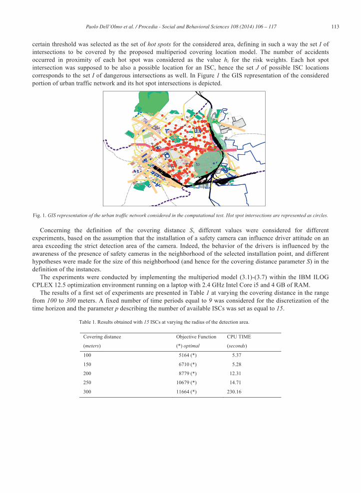
The experimental study on the proposed model was performed by taking into account a portion of the urban traffic network of the city of Rome, namely the area corresponding to the III municipality. A set of 1500 accidents registered in a period of three years on such portion of the traffic network was considered as the initial dataset to compute risk weights associated to the intersections.
The original traffic network was composed by about 1000 intersections and 4000 arcs. A preprocessing of the input data was performed in order to obtain realistic instances for the considered problem as follows. A Geographical Information System was developed, representing the whole traffic network, and a preliminary crash concentration analysis was performed by projecting and overlapping the locations of the accidents dataset on the layers of the GIS network. Thus, a subset of 300 intersections presenting a number of accidents higher than a
113 Paolo Dell’Olmo et al. / Procedia - Social and Behavioral Sciences 108 ( 2014 ) 106 – 117
certain threshold was selected as the set of hot spots for the considered area, defining in such a way the set I of intersections to be covered by the proposed multiperiod covering location model. The number of accidents occurred in proximity of each hot spot was considered as the value hi for the risk weights. Each hot spot intersection was supposed to be also a possible location for an ISC, hence the set J of possible ISC locations corresponds to the set I of dangerous intersections as well. In Figure 1 the GIS representation of the considered portion of urban traffic network and its hot spot intersections is depicted.
Fig. 1. GIS representation of the urban traffic network considered in the computational test. Hot spot intersections are represented as circles.
Concerning the definition of the covering distance S, different values were considered for different experiments, based on the assumption that the installation of a safety camera can influence driver attitude on an area exceeding the strict detection area of the camera. Indeed, the behavior of the drivers is influenced by the awareness of the presence of safety cameras in the neighborhood of the selected installation point, and different hypotheses were made for the size of this neighborhood (and hence for the covering distance parameter S) in the definition of the instances.
The experiments were conducted by implementing the multiperiod model (3.1)-(3.7) within the IBM ILOG CPLEX 12.5 optimization environment running on a laptop with 2.4 GHz Intel Core i5 and 4 GB of RAM.
The results of a first set of experiments are presented in Table 1 at varying the covering distance in the range from 100 to 300 meters. A fixed number of time periods equal to 9 was considered for the discretization of the time horizon and the parameter p describing the number of available ISCs was set as equal to 15.
Table 1. Results obtained with 15 ISCs at varying the radius of the detection area.
Covering distance
(meters)
Objective Function
(*) optimal
CPU TIME
(seconds)
100 5164 (*) 5.37
150 6710 (*) 5.28
200
250
300
8779 (*)
10679 (*)
11664 (*)
12.31
14.71
230.16

114 Paolo Dell’Olmo et al. / Procedia - Social and Behavioral Sciences 108 ( 2014 ) 106 – 117
By observing this first set of experiments, it turns out how the proposed multiperiod model permits to find the
optimal solution for the considered instances in limited computational times on the considered experimental framework. It is also evident how the quality of the solution in terms of total weighted coverage on the considered time horizon increases when the radius of the ISC detection area is supposed to increase.
A second set of experiments was conducted to highlight the effects of the price of rotation concept already introduced in the last part of the previous section. The number of ISCs for this second set of tests was fixed to 30, while the covering distance parameter was fixed to 300 meters. The value of the objective function for the optimal solution was measured at varying the number of periods for the discretization of the time horizon, from 1 time period (equivalent to the static model presented in subsection 3.1) to 9 time periods. In Table 2 the results of this test are presented, also computing, for each case, the mean weighted coverage value with respect to the number of considered time periods.
115 Paolo Dell’Olmo et al. / Procedia - Social and Behavioral Sciences 108 ( 2014 ) 106 – 117
Table 2. Results obtained with 30 ISCs at varying the number of time periods. Time periods (T) Objective Function
(*) optimal
Mean Coverage value
per time period
CPU Time
(seconds)
1
2
3
4
5
6
7
8
9
1577 (*)
3136 (*)
4694 (*)
6206 (*)
7717 (*)
9219 (*)
10699 (*)
12148 (*)
13502 (*)
1577
1568
1565
1552
1543
1537
1528
1519
1500
0.02
0.14
0.14
0.33
0.55
6.26
2.75
9.09
29.06
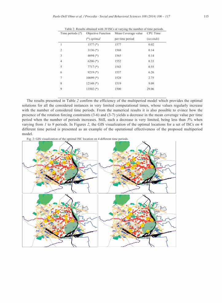
The results presented in Table 2 confirm the efficiency of the multiperiod model which provides the optimal solutions for all the considered instances in very limited computational times, whose values regularly increase with the number of considered time periods. From the numerical results it is also possible to evince how the presence of the rotation forcing constraints (3-6) and (3-7) yields a decrease in the mean coverage value per time period when the number of periods increases. Still, such a decrease is very limited, being less than 5% when varying from 1 to 9 periods. In Figures 2, the GIS visualization of the optimal locations for a set of ISCs on 4 different time period is presented as an example of the operational effectiveness of the proposed multiperiod model.
Fig. 2: GIS visualization of the optimal ISC location on 4 different time periods.
116 Paolo Dell’Olmo et al. / Procedia - Social and Behavioral Sciences 108 ( 2014 ) 106 – 117
Conclusions and further lines of research
In the last years, several studies highlighted the dramatically high impact in terms of deaths and injured people of car accidents occurring within urban traffic areas. Traffic law enforcement and control programs, such as those implemented by installing Intersection Safety Cameras at the most dangerous crosses of the traffic network, showed a positive role in reducing the number and the impact of car accidents. A limit of ISC programs is related to the lack of public resources assigned to traffic agencies in order to develop such programs, yielding to the availability of a limited number of ISCs for monitoring large networks. Moreover, the location of cameras at fixed positions for large periods of time reduces the effectiveness of the program in influencing positively the driving style of the citizens.
The multiperiod maximal covering location model proposed in this paper aims at supporting the implementation of effective ISC programs by computing the optimal locations for ISCs starting by historical datasets on the past accidents occurred on a traffic network. The proposed dynamic MCLP model provides different sets of locations for ISCs, one for each time period of a discretized time horizon. The presence of additional constraints ensure the ISC locations related to different time periods to differ from each other and to cover, on the overall time horizon, the whole set of dangerous intersections of the network. The general goal of the model is the maximization of the weighted coverage on the whole considered time horizon.
A computational test was performed on realistic instances, arising from a dataset on car accidents occurred in the III municipality of Rome during a period of three years.
The results confirmed the operational effectiveness and the computational efficiency of the proposed multiperiod model for the considered set of instances, providing in limited CPU times optimal solutions whose mean coverage per time period value is very near to the optimal static solution.
Further lines of research on this topic lie in the extension of the computational experiments on the whole traffic network of Rome, and on the development of heuristic methods in order to cope with very large scale instances of the considered problem.
Acknowledgements
The authors wish to thank Dott. Domenico Iovino for his contribution in the computational test of the model during his work on the thesis (Iovino, 2012). We are also deeply grateful to Ing. Colicchia and Dott. Chiusolo from ACI Consult S.p.a. for their collaboration on the development of this project.
References
Church, R., & ReVelle, C. (1974). The Maximal Covering Location Problem. Papers of the Regional Science Association, 32(1), 101-118. Berman, O., Drezner, Z., & Krass, D. (2010). Generalized coverage: new developments in covering location models. Computers & Operations Research, 37, 1675-1687. Pirkul, H., & Schilling, D. (1989). The capacitated maximal covering location problem with backup service. Annals of Operations Research, 18, 141-154. Galvão, R.D., & ReVelle, C. (1996). A Lagrangean heuristic for the maximal covering location problem. European Journal of Operational Research, 88, 114-123, 1996. Brotcorne, L., Laporte, G., & Semet, F. (2002). Fast heuristics for large scale covering-location problems. Computers & Operations Research, 29, 651-665. ReVelle, C., Scholssberg, M., & Williams, J. (2008). Solving the maximal covering location problem with heuristic concentration. Computers & Operations Research, 35, 427- 435, 2008.
117 Paolo Dell’Olmo et al. / Procedia - Social and Behavioral Sciences 108 ( 2014 ) 106 – 117
Senne, E.L.F., Pereira, M.A., & Nogueira Lorena L.A. (2010). A Decomposition Heuristic for the Maximal Covering Location Problem. Advances in Operations Research, 2010. Zarandi, M.H.F., Davari, S., & Sisakht, S.A.H. (2012). The large-scale dynamic maximal covering location problem. Mathematical and Computer Modelling, 57(3-4), 710-719. Murray, A.T., Kim, K., Davis, J.W., Machiraju, R., & Parent, R. (2007). Coverage optimization to support security monitoring. Computers, Environment and Urban Systems, 31, 133-147. Rajagopalan, H.K., Saydam, C., & Xiao, J. (2008). A multiperiod set covering location model for dynamic redeployment of ambulances. Computers & Operations Research, 35, 814-826. Curtin, K. M., Hayslett-McCall, K., & Qiu, F. (2010). Determining Optimal Police Patrol Areas with Maximal Covering and Backup. Networks and Spatial Economics, 10, 125-145. Sayed, T., & de Leur, P. (2007). Evaluation of Intersection Safety Camera Program in Edmonton, Canada. Transportation Research Record: Journal of the Transportation Research Board, 37-45. Iovino D. (2012). Localizzazione di telecamere per il controllo dell’incidentalità stradale. Tesi di Laurea Specialistica in Scienze Statistiche e Decisionali. Relatore: Prof. Nicoletta Ricciardi. Correlatore: Prof. Paolo Dell’Olmo. Sapienza Università di Roma. Sessione autunnale A.A. 2011/2012.