80 Kansas History · 80 Kansas History “Corn is King” (1887). Courtesy of the Wichita-Sedgwick...
28
80 Kansas History “Corn is King” (1887). Courtesy of the Wichita-Sedgwick County Historical Museum. Kansas History: A Journal of the Central Plains 38 (Summer 2015): 80–107
Transcript of 80 Kansas History · 80 Kansas History “Corn is King” (1887). Courtesy of the Wichita-Sedgwick...

80 Kansas History
“Corn is King” (1887). Courtesy of the Wichita-Sedgwick County Historical Museum.
Kansas History: A Journal of the Central Plains 38 (Summer 2015): 80–107

81Peerless Princess of the Southwest
“Peerless Princess of the Southwest”: Boosterism and Regional Identity
in Wichita, Kansasby Jay M. Price
In 1887 the Wichita Board of Trade issued an elaborate map celebrating the city’s prominence as a regional trade and commercial center. Wichita appeared as a bustling powerhouse of activity in Kansas and the central United States. Exaggerated scale highlighted Wichita’s purported status as a hub of rail lines that extended to New Orleans, Galveston, El Paso, Los Angeles, Denver, Kansas City, Omaha, and Chicago. Equally striking were the slogans and
titles that described the city as the “Peerless Princess of the Plains,” the “Magical Mascot,” the “Mecca of Men,” the “Jerusalem of the West,” and the “Favored City.” In the upper corner was a blank space for a sponsoring organization. The Wichita Journal of Commerce, for example, did so, mentioning that it was in “the Great Southwest, Wichita, Its Metropolis.”1
A century later, equating Wichita with the Southwest would seem odd. By the 1980s, the term “southwestern” evoked images of howling coyotes, saguaros, Mexican food, and adobe architecture.2 Depending on the speaker, Wichita was a city of the Midwest, which extended from Kansas to the Great Lakes; the Great Plains, which ran from the Dakotas down to Texas; or an ill-defined “Heartland,” where fields and farms extended to the flat horizon, punctuated by massive grain elevators. Regardless of specific regional affiliation, however, one feature stood out: location. Wichita was in the center of the country, roughly equidistant from both coasts and from the Canadian and Mexican borders. Located less than two hundred miles from the geographical center of the contiguous forty-eight states, Wichita was about as “middle” of the country as a city could be. This sense of being “central” permeated local identity. In the 1970s, the Chamber of Commerce used the slogan “Center City, USA.” The 1992 Official Visitor’s Guide from the Convention and Visitor’s Bureau included a statement from bureau president CEO Joe Boyd welcoming the reader “to America’s New Center of Attraction, Wichita Kansas,” where “our central geographic location places us right in the ‘heartland of America.’” This was during the years when the Miss USA pageant took place in Wichita, with one opening number including the contestants singing as a group about how they were “Right in the Middle.”3
Jay M. Price is chair of the Department of History at Wichita State University, where he also directs the public history program. With a focus on local and community history as well as the built landscape, his publications include Temples for a Modern God: Religious Architecture in Postwar America; Gateways to the Southwest: The Story of Arizona State Parks; Wichita: 1860–1930, and El Dorado: Legacy of an Oil Boom. He has co-authored Wichita’s Legacy of Flight; The Cherokee Strip Land Rush; Wichita’s Lebanese Heritage; Kansas: In the Heart of Tornado Alley; and Wichita: 1930–2000. He has recently served on the boards of the Kansas Humanities Council, the Wichita-Sedgwick County Historical Museum, and the University Press of Kansas.
1. Reprinted in R. M. Long, Wichita Century: A Pictorial History of Wichita, Kansas, 1870–1970 (Wichita, Kans.: Wichita Historical Museum Association, 1969), 232–33.
2. See, for example, Christine Mather and Sharon Woods, Santa Fe Style (New York: Rizzoli, 1986); and Elmo Baca, Southwest Expressions (Lincolnwood, Ill.: Publications International, 1992).
3. Wichita Convention and Visitor’s Bureau, Official Visitor’s Guide (Wichita, Kans.: Wichita Convention and Visitor’s Bureau, 1992). The Miss USA pageant song was part of a video retrospective of the bureau, now “Visit Wichita,” at the organization’s annual meeting, February 19, 2015.

82 Kansas History
If there was a regional connection to the city, it was to the Midwest. In 1984 the U.S. Census Bureau merged its “West North Central” and “East North Central” divisions into a single “Midwest” region with Kansas as the southwestern corner of an official designation that extended up to North Dakota and out to Ohio. This redefinition coincided with the start of a renewed interest in scholarship that studied and tried to identify the Midwest. In his 1989 book, The Middle West, geographer James R. Shortridge outlined national perceptions about the boundaries of the region. In looking at cognitive maps from the 1950s through the 1980s, he found that Kansas and Nebraska were indisputably the “core” of what it meant to be midwestern. Shortridge represented a tradition of scholarship on the region that has debated the nature and borders of the Midwest, but has long included Kansas. It is a sentiment that could be summarized by a comment from historian John D. Hicks back in 1958: “The twelve North Central States are all Middle West and should know it.” Whether the observations came from scholars or convention promoters, the logic was straightforward: Kansas was in the Midwest. Wichita was in Kansas. Therefore, Wichita was in the Midwest.4
Yet, regionalism has always been more challenging than might seem apparent at first, even in a place like Kansas. The Sunflower State might best be thought of as the great meeting ground of America’s regions.5 In Kansas the North and the South, the East and the West, the Great Plains, the Midwest, the Southwest, and the Ozarks all come together. Parts of the state have their own unique regional affiliations, such as the “Cross Timbers” region of southeastern Kansas that has ties to Oklahoma or the “Little Ozarks” of the coal and lead country, where cultural and economic connections lean to Joplin and
4. John D. Hicks, “A Political Whirlpool,” in The Heritage of the Middle West, ed. John D. Murray (Norman: University of Oklahoma Press, 1958), 76; James R. Shortridge, The Middle West: Its Meaning in American Culture (Lawrence: University Press of Kansas, 1989), 67–96. For the U.S. Census distinctions, see, for example, “Statistical Groupings of States and Counties,” http://www2.census.gov/geo/pdfs/reference/GARM/Ch6GARM.pdf and the map at.http://www2.census.gov/geo/pdfs/maps-data/maps/reference/us_regdiv.pdf. See also Andrew R. L. Cayton and Susan Gray, eds., The American Midwest: Essays on Regional History (Bloomington: Indiana University Press, 2001); and John Lauck, The Lost Region: Toward a Revival of Midwestern History (Iowa City: University of Iowa Press, 2013); David M. Wrobel and Michael C. Steiner, eds. Many Wests: Place, Culture, & Regional Identity (Lawrence: University Press of Kansas, 1997).
5. Even Frederick Jackson Turner noted this fusion in his essay “The Middle West”: “Illinois and Ohio together sent perhaps one-third of the native element of Kansas and Nebraska, but the Missouri and Southern settlers were strongly represented in Kansas.” Frederick Jackson Turner, “The Middle West,” International Monthly 4 (December 1901): 794–820.
Springfield, Missouri.6 On the other side of the state, Dodge City and Garden City have looked to the Texas and Oklahoma panhandles more than Topeka, forming the basis, for example, of an unsuccessful secession movement in 1992 to create the new state of West Kansas.7 Places such as these have a sense of local identity markedly different from the Manhattan–Topeka–Lawrence corridor along the Kansas River.
Wichita is another place that has a complicated regional affiliation. James Byrkit’s “The Southwest Defined” in Journal of the Southwest highlights how Kansas, or at least portions of it, has been part of that region, even more than part of the Midwest. Byrkit suggested that a simple division of the continental U.S. into quadrants, with the center being near Lebanon, Kansas, created a tidy, if artificial, designation. From that point (roughly 98 degrees at the 40th parallel), the “Southwest” arced down through western Kansas, Oklahoma, and Texas, extending through the lands acquired in the wake of the Mexican-American War, to the Pacific Coast. Doing so made Arizona and New Mexico the heart of the region, as the only two states that fall completely within these boundaries. It also placed Wichita technically in the Southeast, a connection that, some would argue, was relatively accurate, especially in regards to race relations.8
Yet, an even stronger connection for Wichita has been with the Southwest, a legacy almost absent in contemporary depictions of the community, both from the outside and from residents themselves. This was not the late twentieth-century “Santa Fe Style,” but, in the words of W. Eugene Hollon, the “Old Southwest” of Texas and Indian Territory, a dry arid and semi-arid “frontier” where Anglo-American, Spanish, and Native populations interacted.9 Hollon’s characterization of the Southwest, rooted in geography and frontier encounters, is dated and is perhaps too tied to the Turnerian old western history, but it did define a region that was in the minds of Wichitans for much of that city’s early history.
6. See James R. Shortridge, Peopling the Plains: Who Settled Where in Frontier Kansas (Lawrence: University Press of Kansas, 1995), 46–71; Homer E. Socolofsky and Huber Self, Historical Atlas of Kansas, 2nd ed. (Norman: University of Oklahoma Press, 1988); and, for example, Richard V. Francaviglia, The Cast Iron Forest: A Natural and Cultural History of the North American Cross Timbers (Austin: University of Texas Press, 2000) and Jeff Wells, “Joplin, Missouri, and the Search for Regional Identity,” Mid America Conference on History, September 19, 2014.
7. Shortridge, Peopling the Plains, 142–88; see also Peter J. McCormick, “The 1992 Secession Movement in Southwest Kansas,” Great Plains Quarterly 15 (Fall 1995): 247–58.
8. James Byrkit, “Land, Sky, and People: The Southwest Defined,” Journal of the Southwest 34 (Autumn 1992): 255–387, 266.
9. W. Eugene Hollon, The Southwest: Old and New (1961; repr., Lincoln: University of Nebraska Press, 1970), 3–20.

83Peerless Princess of the Southwest
Kansans as a group may not have thought of themselves as southwesterners, but for almost one hundred years, Wichitans most certainly did.
Regional identity in the United States is inherently a construct, depending on who is doing the framing. Geographers with the U.S. Census Bureau have at times looked to physiographic regions, and cultural historians discuss local identity as reflected in literature. In many cases, however, regional markers are functions of business development and boosterism. Far from being organic, a place’s identity is often based on features that local promoters want to emphasize. In Devil’s Bargains, for example, Hal Rothman noted that the tourist industry has tended to exaggerate certain elements of a place to draw visitors and downplay features that did not conform to that image. Architecture, food, music, language, and landscapes can all be adapted and commodified to create the sense, even illusion, that a location is a unique place different from the rest of the country.10
Business and industry can define and shape local identity even in places that are not tourist destinations, however. Trade areas, real estate, and industrial development can play their own roles. Wichita, Kansas, was one such place. Throughout its history, it has shifted its regional connections. In many cases, these shifts correlated with changes in the local economy and reflected the most promising areas of development for local entrepreneurs. As certain industries faded and new ones emerged, Wichita’s sense of self changed as well.
Wichita is a city of boosterism. Its newspapers, most notably the Wichita Eagle and the Wichita Beacon, have been booster organs. These papers not only recorded changes in the community’s economic fortunes, they have been instrumental in shaping those fortunes. Editors such as Marshall Murdock were expected to promote the city and were well connected with the city’s business elite. Other organizations such as the Board of Trade, Commercial Club, the Chamber of Commerce, and Convention and Visitor’s Bureau have played their own roles in defining Wichita over the decades. Accessing these sources has been a challenge at times as there was no reliable index outside of the personal notes of Dr. Edward Tihen. Today, however, digitization of Wichita newspapers through NewsBank, Chronicling America, and other databases has allowed researchers to investigate these sources more fully. Moreover, the digitization of promotional materials through HathiTrust Digital Library, Kansas Memory, and other sources has allowed historians to gain a fuller
picture of a community’s history, enhancing while not replacing physical materials in various repositories. When examined, these sources suggest a more complicated and fluid sense of regional identity compared to the Kansas communities along the Kaw River.
Before there was a Wichita, or even a Kansas, this region at the confluence of the Big and Little Arkansas Rivers looked southward and westward. Spanish explorers such as Francisco Vázquez de Coronado and Juan de Oñate entered Kansas from the pueblos of the Rio Grande. Centuries later, the Arkansas River served as a highway and conduit for explorers such as Zebulon Pike and the detachment from the Stephen Long Expedition. By the 1850s, a series of north-south routes connected forts, missions, and relocated American Indian tribes in Indian Territory to the region’s main thoroughfare, the Santa Fe Trail. One of these was the Cherokee Trail that ran from Tahlequah and Fort Gibson up the Arkansas River to near what is now Galva in McPherson County.11 Ties between Kansas and Indian Territory continued during the Civil War, when pro-Union members of tribes in Indian Territory, such as among the Wichita, fled north. The Wichitas eventually ended up along the Little Arkansas River in what was then the western part of Osage land. This was the camp that drew traders such as James R. Mead, who built his trading post at the confluence of the rivers in 1864.12
In the 1860s, trade tied this area to American Indian populations in what remained of Indian Territory. The best known route was popularized by Jesse Chisholm, who helped develop and popularize a trail between his trading post by the North Canadian River (near present-day Oklahoma City) and a post near the present site of Wichita. The Arkansas River had been a trade corridor for generations, with trails appearing on U.S. military maps in the 1840s and 1850s. According to James R. Mead, however, it was Chisholm who laid out the best route between the two locales in early 1865, as he guided a wagon train of goods down to Indian Territory and
11. See, for example, Thomas Jekyll, “Map of the United States and Their Territories between the Mississippi and the Pacific Ocean and Part of Mexico. Compiled from Surveys Made under the Order of W. H. Emory. Major 1st Cavalry, U.S. Commissioner,” 1857–1858, accessed at http://specialcollections.wichita.edu/collections/maps/detailsframes.asp?offset=20&var=1857-0009. See also the work of Pat and Jack Fletcher on the Cherokee Trail at http://cherokeetrail.org/.
12. James R. Mead, Hunting and Trading on the Great Plains, 1859–1875, ed. Schuyler Jones (Wichita, Kans.: Rowfant Press, 2008), 191; see also W. G. Coffin, Report of Office of the Superintendent of Indian Affairs, Southern Superintendency, September 24, 1864, report no. 142 in Report of the Secretary of the Interior, U.S. Congressional Serial Set 1220 (Washington, D.C.: Government Printing Office, 1865).
10. Hal Rothman, Devil’s Bargains: Tourism in the Twentieth Century American West (Lawrence: University Press of Kansas, 1998).

84
Once thought of as a major marketplace of the Southwest, Wichita’s regional identity was closely tied to local interests and changed over time as the business community and city government sought new ways to distinguish it from other major cities. The Chamber of Commerce launched the “Center City, USA” marketing campaign in the late 1960s in order to reinforce Wichita’s national significance, continuing a shift in affiliation from the Southwest to the Midwest that began at the turn of the century. Courtesy of the Wichita Metro Chamber of Commerce.
Kansas History

85Peerless Princess of the Southwest
back again, followed that summer by a drive of cattle south from west of the Wichitas’ camp at the confluence of the Big and Little Arkansas down to the Sac and Fox agency. Within a few years, figures such as Buffalo Bill Matthewson and William Greiffenstein were using “Chisholm’s Trail” as an important trade route down to what remained of Indian Territory. In 1867 the Wichitas returned to Indian Territory along this route. That same year, Joseph G. McCoy established a cattle operation at Abilene, the westernmost terminus of the Kansas Pacific. Cattle coming up from Texas arrived in Abilene to be loaded onto railcars and shipped to Chicago. Thus began a tide of cattle and cowboys up from Texas to railheads in Kansas.13
By 1868 the settlement that began with the Wichitas’ camp near the confluence of the Big and Little Arkansas Rivers, still then in Osage lands, was transitioning into an Anglo-American settlement. An article in the Emporia News on March 6, 1868, noted:
The country on the east of the Little Arkansas and on both sides of Chisholm and Gypsum Creeks is of extraordinary beauty and fertility. I think I never saw such rich and abundant grass anywhere before. This is evidently the paradise of stock raisers. Near the mouth of the Little Arkansas, near its east branch, is where the Wichita, Kechi, Waco, Caddo and other bands of “loyal Indians” have been camped and fed for the past two or three years. . . . This is the point to which all the roads center from the great southwest, and here is the favorite crossing of the Texas drovers and traders; and here will meet and cross the Fort Scott, Sedalia & Santa Fe, and the Atchison, Topeka & Santa Fe Railroads. E. H. Durfee & Co., of Leavenworth, have established a large trading and outfitting post here and already have a large stock of goods on hand, and propose to largely increase it in the spring.
The phrase “great southwest” is telling, indicating a connection to Texas and beyond, tied especially to the cattle trade. The Chisholm Trail was a highway that linked Wichita through Indian
Territory to Texas. This connection showed up in, for example, the creation of the Southwestern Stage
Company that operated a line connecting Wichita down the Chisholm Trail through the Cheyenne, Arapaho, Wichita, and Comanche lands to Sherman, Texas.14
During much of the nineteenth century, the Southwest was more accurately the western South. D. W. Meinig has shown that in the early nineteenth century, those who took part in the colonization and settlement of the Transappalachian West between the Appalachian Mountains and the Mississippi often spoke of the region as divided into two parts: the Northwest above the Ohio River, and the Southwest below it. While the term Old Northwest has remained to describe places such as Indiana and Illinois, for example, the Old Southwest has been less known but still significant. James Byrkit observed that from the 1840s through the Civil War, “the term ‘Southwest’ cartographically designated Tennessee, Alabama, and Missouri,” while until 1900, “the expression usually referred to Arkansas, Oklahoma, Louisiana, and Texas.”15 It was for this reason that the journal of the Texas State Historical Association came to be called, as of 1912, the Southwestern Historical Quarterly. Historian Robin Cole-Jett has noted that the Red River, extending through Arkansas into Indian Territory and eventually forming the border between Oklahoma and Texas, was “a constant juxtaposition of the South and West.” It was this borderland between Indian Territory and Arkansas down through eastern Texas and western Louisiana “that nineteenth-century surveyors deemed the Great Southwest—and what scholars sometimes now call the ‘Old Southwest.’” In the middle of the nineteenth century, the South-Western was the newspaper of Shreveport, Louisiana, while the South-West Independent came out of Fort Smith, Arkansas.16
By the late 1860s and 1870s, however, the Old Southwest was no longer Tennessee, Mississippi, Arkansas, and Louisiana. The development of a slave-based cotton industry along the Mississippi, the Sectional Crisis, the formation of the Confederacy, the Civil War, and Reconstruction had largely redefined those places as part of the South.17 The Southwest was west of that and included Texas, Indian Territory, and, by extension, places in southern Kansas such as Wichita. In 1870 the newly incorporated town of Wichita found itself along
13. John Rossel, “The Chisholm Trail,” Kansas Historical Quarterly 5 (February 1936): 3–14; Stan Hoig, Jesse Chisholm: Ambassador of the Plains (Norman: University of Oklahoma Press, 1991); Mead, Hunting and Trading on the Great Plains, 191–97; Joseph McCoy, Historic Sketches of the Cattle Trade of the West and Southwest (Kansas City, Mo.: Ramsey, Millett & Hudson, 1874), accessed via kancoll.org/books/mccoy/.
14. Emporia News, November 3, 1871.15. Byrkit, “Land, Sky, and People: The Southwest Defined,” 266.16. Robin Cole-Jett, The Red River Valley in Arkansas: Gateway to the
Southwest (Charleston, S.C.: History Press, 2014), 10; see also D. W. Meinig, The Shaping of America: A Geographical Perspective on 500 Years of History, vol. 2, Continental America, 1800–1867 (New Haven, Conn.: Yale University Press, 1986), 224, 231–36.
17. Meinig, The Shaping of America, vol. 2, 431–528.

86 Kansas History
Chisholm’s river of beeves, although it was more of a through-station than end point at first. In 1871 the Atchison, Topeka, and Santa Fe (AT&SF) arrived at Newton, the newest railhead. The main line of the AT&SF ran in a southwesterly direction towards New Mexico, across Arizona and to California, all reinforcing ties of south central Kansas to that portion of the country. Indicative of the city’s orientation and aspirations, the spur line that tied it to the AT&SF at Newton was the locally created railroad: the Wichita and Southwestern. Financed through $200,000 in public bonds, the railroad, with local booster James R. Mead as president, began construction in late 1871.
In the middle decades of the nineteenth century, railroad names tended to have two parts: where they started and where they aspired to go. The designation “southwestern” was especially telling, therefore, since the road’s primary purpose was to run north from Wichita to the main AT&SF line. However, just two weeks after the first train arrived on a rainy evening in May 1872, the Wichita City Eagle reported that the line received a “contract for the shipment of government freight to this point for forts south and west of here.”18 Wichitans had larger goals in mind, goals that looked down to Indian Territory and beyond. Those aspirations never materialized, although a decade later, the Santa Fe began building its own routes down to Winfield, Wellington, and beyond. The Wichita and Southwestern’s primary significance was that it ushered in the main run of the cattle trade in the summer of 1872, marking the start of that city’s four-year-long heyday as a major cattle town.19
Wichita was not solely an extension of Texas. The main market for cattle was in Chicago, and the main street of Delano was Chicago Avenue, later West Douglas. The Chicago Drug Store was an early fixture, as was the New York Store and the Philadelphia Store. However, the city’s business links definitely looked to the Lone Star State. The very title of Joseph McCoy’s history of the cattle trade that discussed his work in Abilene and later Wichita was Historic Sketches of the Cattle Trade of the West and Southwest.20 The city paid Abel “Shanghai” Pierce $2,000 a year to operate the city stockyards and to promote the
city’s cattle trade among his Texas colleagues.21 The year 1872 saw the erection of the Texas Headquarters, “the designment of the large house, 25x100, being erected near the Avenue Hotel. The second story is to be fitted up for the special lounging place of Texas men. The lower story will be used as bank depository for them. It is built by Texas men.”22 This “headquarters” operated through two cattle seasons, lasting until October 1873.23
The cattle years tied Wichita’s business interests to Texas. There was a reason why one of the most important streets in the West Wichita community of Delano was Texas Street and in local lore, Texan and cowboy—and the Southwest—were nearly synonymous. As an article in the Wichita City Eagle from 1875 recalled,
At that time [1873] the streets were thronged with Texan cow boys, with huge spurs on their heels, and howitzers strapped upon their backs. Every other door opened into a saloon. The first thing heard in the morning and the last at night was the unceasing music at the saloons and gambling houses. The town was headquartes [sic] for harlots for two hundred miles around. Fighting, shooting and even killing were not infrequent. . . . Gamblers were more numerous than respectable men. Those were days of the cattle trade in its glory.24
In the newspapers, drovers were assumed to be Texans. The same Eagle edition that mentioned the Texas Headquarters also noted how violence was an unpleasant consequence of the industry. “Many a Texas boy who came up to Kansas with his herds and boon companions would have returned to his far-off home and friends in the lone star state, but for the revolver and bowie knife,” lamented the article. “The Texas boys are as quiet and peaceable as any class of citizens, but like many other men are dangerous when armed and maddened with whisky or the wiles of a woman.” The solution, it seemed, was to limit the presence of weapons, “in the name of our people, in the name of cattle dealers’ and drovers’ homes in Texas.”25 The local papers clearly distinguished Wichitans from the Texas drovers. Wichita was not in
18. Wichita City Eagle, May 31, 1872.19. See “Southwestern Kansas,” Wichita City Eagle, January 20, 1876;
“Railroad Stock Meeting,” Wichita City Eagle, December 12, 1878; see also Mead, Hunting and Trading on the Great Plains, 14; and H. Craig Miner, Wichita: The Magic City (Wichita, Kans.: Wichita-Sedgwick County Historical Museum, 1988), 9–30.
20. McCoy, Historic Sketches of the Cattle Trade.
21. Born in Rhode Island, Pierce became established in the Texas cattle trade as a young man and developed considerable ties to the industry of that state.
22. Wichita City Eagle, June 7, 1872.23. Wichita City Eagle, October 2, 1873.24. Wichita City Eagle, December 2, 1875.25. Wichita City Eagle, June 7, 1872.

87Peerless Princess of the Southwest
Texas. However, the Lone Star State made its impression on the city more than almost any other region.26
The cattle years lasted only until 1876, when the quarantine line moved to Dodge City. The flow of cattle through Wichita was already shrinking; local leaders such as Marshall Murdock were tiring of the vice that cowboys seemed to bring with them. From the 1870s on, however, Wichita’s leading business figures turned their attention to getting more railroad connections, agriculture, industry, and real estate. Their new passion was “booming” the community into the next Chicago. A frenzy of promotion ensued, much of it connecting Wichita to the promising expansion of the American Southwest, especially Texas and Oklahoma. The connection of Wichita to Texas and the Southwest was without dispute in the 1870s and 1880s. The heyday of the trail drives was gone, but local cattle interests shifted their focus from trail drives to regional ranches, including those in and along the Cherokee Outlet. Meanwhile, the arrival of farmers and the development of railroad towns in southern and western Kansas, in the Texas Panhandle, and eventually in Indian Territory suggested a regional market for Wichita’s businesses and stores. The Wichita Eagle’s editor, Marshall Murdock, more than almost anyone else, defined the city’s identity in the 1870s, 1880s, and 1890s. It was Murdock, for example, who wrote the famous “She Spreads So” article in the November 27, 1886, edition that described Wichita as “The Magical Mascot of the Sixth Meridian, The Pride of the Prairies, the Peerless Princess of the Plains.”27 A story from Murdock’s wife, Victoria, in 1913, recalled how and why her husband came to Wichita back in 1872. It also suggests how Murdock viewed Wichita: “Then M. would say: ‘When the Osage ceded lands come in at the junction of the Arkansas rivers, there will be the city of the southwest. I am going there when that time comes, build that city for you and call it the Peerless Princess of the Plains.”28 Victoria Murdock’s recollection in this piece is problematic as it conflates several events that took place over a number of years into a single narrative. Yet, it does suggest that she thought of the city, like so many boosters, as a southwestern one.
Today, the title “Peerless Princess of the Plains” implies “Great Plains.” However, in the late nineteenth and early
twentieth centuries, the designation “plains” was more fluid. Back in 1877, for example, an article in the Wichita Eagle about the need for windbreaks argued for their use as shields against “the sweeping currents of dry air which come to us from the vast sultry plains of the southwest.”29 Thus, the plains could be as much a part of the Southwest as the saguaro. Nor was the “peerless princess” moniker exclusively reserved for the “plains.” In October 1888, the Boston Store, the venture of Charles Cohn and Henry Wallenstein and one of the largest department stores in the city, ran an ad promoting the store as a fixture in Wichita, “the Peerless Princess of the Southwest.”30
In the early 1870s, references to the “Southwest” in the local papers tended to mean southwestern Kansas, given that Wichita represented the southernmost and westernmost city of any size in the state. As Wichita grew, however, so did its regional aspirations. By the middle of the 1880s, the city’s leaders thought of themselves as serving a vast region that included much of Indian Territory, the Texas Panhandle, and beyond. For a time, Wichita rivaled Dallas in size and if traveling on the AT&SF, the next cities of appreciable size were in California. At times, though, Wichita could be as much western as it was southwestern, as evidenced in the moniker, “Wonderful City of All the Great West.” As a writer in the Eagle once put it, “while roaming over the ‘great west’ I find myself -on this beautiful winter day in the Wonderful Winning Wichita, the Great City of the Arkansas Valley.”31
Wichita papers made occasional references to the city as being in the “Mid-west.” One example was in 1888, when an article in the Wichita Eagle referred to a Reformed Church college maintaining the heritage of the Reformation “here in the mid-west.”32 This was the concept of the Middle West that developed in the 1880s. Shortridge noted that the term was originally used with a horizontal orientation to the map: the “West” was made up of the Northern West (the Dakotas), the Southern West (Texas), and the Middle West (Kansas and Nebraska). This designation perhaps made sense for the large cities along the Missouri between the Platte and the Kaw Rivers. Indeed, the identity of “Kansas” as it developed in the late nineteenth century lionized the free-state legacy of the communities from Kansas City to Lawrence, Topeka, Manhattan, and Salina. Topeka was, in addition
26. Byrkit, “Land, Sky, and People: The Southwest Defined.” See also Meinig, The Shaping of America, vol. 2, 231–36; and Stan Hoig, Cowtown Wichita and the Wild, Wicked West (Albuquerque: University of New Mexico Press, 2007).
27. “She Spreads So,” Wichita Eagle, November 27, 1886.28. “Boomed Wichita in Honor of His Wife,” Wichita Eagle, January
3, 1915.
29. Wichita City Eagle, October 18, 1877.30. Wichita Eagle, October 4, 1888.31. Wichita Eagle, January 28, 1887.32. Wichita Eagle, March 6, 1888.

88 Kansas History
to being the capital, the largest city in the state and saw itself as Kansas’s dominant community, even after 1886, when the consolidation of communities in Wyandotte County formed Kansas City, Kansas, the state’s most populous city. Wichita, like Dodge City and Pittsburg, was well distant from the Kaw. It was (and remains) on the frontiers of true “Kansasness.” This ambiguity has permeated Wichita’s sense of identity ever since.33
By the late 1880s, meanwhile, Wichitans were starting to see their city as more than a regional terminus. It was nothing less than the hub of the nation itself, as evidenced in the 1887 promotional map. In April 1889, on the eve of the first great Oklahoma land rush, the Eagle opined that Wichita’s key role in the rush and in supplying the communities that would develop in its wake was just the start of the city’s rise to regional prominence. “All geographical lines are merely imaginary, but all lines of traffic make centers of trade,” the Eagle suggested, hinting that trade was the key to future greatness. “Water ways are rapidly giving way to the steel rail and its tireless wheels. The future great cities of America will be mid-continent cities.” Looking to Chicago as an example, the article echoed a frequent booster theme: great cities of the center of the country were the heart of American greatness. Wichita was poised to play such a role: “In the center of the United States the commercial center of her central state is Wichita, begotten of events, developed by comprehensive human efforts, and with peerless advantages and unrivalled opportunities is destined to be a center for all that the civilization of the nineteenth century has to offer.” Articles predicted that Wichita would be the greatest city west of Chicago.34
In 1890 an article in the Wichita Eagle proclaimed that recent developments were “sufficient guaranty that Wichita will sweep right along until she has reached the proportions of a great mid-continent, inland,
central city whose commercial influence shall be felt from the junction of her two rivers westward to their sources and again southward across the intervening valleys down to the sea.”35 This statement celebrated the city’s mid-continental status, but then continued to extol its reach to the west and the south, reinforcing a southwestern orientation.
Perhaps the fullest expression of Wichita’s continental aspirations was in an article in the Wichita Eagle on
April 20, 1890, titled “Center of Centers.” Unabashedly boosterist in tone, the article argued, first, that the city’s position as a jobbing hub made it well suited to reach nearly every other part of the nation. The centerpiece was a map that proclaimed Wichita to be the “Central City of the United States,” a map that was similar to the 1887 Board of Trade image, but even more stylized, with no pretense of depicting actual railroad routes. From a central point, indicated by a large sunflower, rail lines radiated in straight lines in all directions. One line, for example, included points such as St. Louis, Cincinnati, New York, and Boston. Another had Kansas City as just one stop on the line to Chicago. Another ran directly to Portland, Oregon, with no intervening stops. The map suggested that Wichita’s location tied it easily to “marts and ports of the Lakes and Gulf and of the oceans of the American continent,” and that
so far as advantage of position in relation to the markets of the entire situation are concerned, if there is a city on the continent that has any advantage over Wichita, the reader will please take down his map and point it out. There are none. It makes no difference whether Wichita’s packing house products or her grain or her live stock are destined for the Atlantic or for the Pacific ocean for the markets of the Gulf or of the Lakes, Wichita is still midway equi-distant, the half-way entrepot, reaching each and all with competitive lines of railway.
The article continued that the recently opened Oklahoma Lands and the soon to be opened Cherokee Outlet constituted another set of opportunities. Other major cities in the center of the country were mere regional outlets given that
Wichita’s lines take in the whole of the rich and fair domain, and the wholesaler and jobber and manufacturer who would have the advantage over all competitors of any other or all other towns and cities must locate in Wichita, composing the prime factor of the entire situation, and as truly the dominant of it as Kansas City is of eastern Kansas, or as Omaha is of eastern Nebraska, or as Chicago is of northern Illinois, Iowa and Wisconsin.36
Although the article described industry and trade, the implication was that Wichita’s mere location destined it to become one of the great cities of the nation. How much the
33. Shortridge, The Middle West, 16–26.34. “Twenty Millions More: Why Wichita Will Be The Greatest City
West of Chicago,” Wichita Daily Eagle, April 14, 1889.35. “A Brief Summing Up for People Who Never Saw But Who Want
to Know about Wichita,” Wichita Daily Eagle, April 6, 1890. 36. “Center of Centers,” Wichita Daily Eagle, April 20, 1890.

89
Wichita’s southwestern identity had its origins in the nineteenth century, when Americans divided the area west of the Appalachians into two regions: the Northwest, including states north of the Ohio River, such as Illinois and Indiana, and the Southwest, south of the Ohio River. The Chisholm Trail tied Wichita to the Southwest in the 1870s, but by the time of the 1947 Chisholm Trail Jubilee, Wichitans associated cattle-driving with the West as a whole. Courtesy of the Wichita Metro Chamber of Commerce.
Peerless Princess of the Southwest

90 Kansas History
Eagle’s staff actually believed the hyperbole will never be fully known. The exaggerated nature of the 1890 articles, coming out just as the investment bubble of the 1880s was starting to burst, hinted more at desperation than regional pride. Just a few years later, factories had gone out of business, real estate speculation had evaporated, and local hopes to be the next Chicago vanished. The term “Mid-Continent” continued to appear in the paper, not as a symbol of civic pride, but in reference to the title of a Christian weekly in Kansas City that later relocated to St. Louis.
As Wichita recovered from the 1890s, its business community looked again to Oklahoma and Indian Territory as a more feasible, modest trade area. With ties to the Arkansas River, as well as the Chisholm Trail and later railroad connections, northern Oklahoma and southern Kansas have been so closely linked through history, demography, economics, and culture that they in some ways have formed a single region rather than the edges of two states. Winding its way through what is now Tulsa, Wichita, and beyond, the Arkansas River was as much a conduit as a border. The cattle drives up the Chisholm Trail brought with them Texas cowboys but also commerce and trade up and down the route. In the 1800s, efforts to settle northern Oklahoma originated out of southern Kansas, with figures such as David Payne organizing his “Oklahomist” movement out of Wichita and Wellington. In the early twentieth century, the oil industry connected communities in Kansas to those of Oklahoma. Moreover, several Wichita business figures, from aviation pioneer Clyde Cessna to Coleman founder W. C. Coleman, got their start in Enid and other northern Oklahoma venues before establishing companies in Wichita. Wichitans came by their orientation to Oklahoma and beyond quite naturally.
Newspaper references suggested that being part of the Southwest was the preferred designation of business and promotion. In 1899 the “Famous” clothing store advertised itself as offering “the most stupendous, magnificent bargains ever offered in the Peerless Princess of the Great Southwest,” as did a similar advertisement for the “Hub” in 1902.37 In the early twentieth century, Wichitans celebrated their southwestern identity in the names of the businesses they created. By 1915 banker L. S. Naftzger had founded the Southwest National Bank. The name was no mere coincidence. In a booster publication, Naftzger discussed banking in the city, which he called the “Metropolis of the Southwest.”38 Meanwhile, the
Southwestern Business College offered correspondence courses.
Into the twentieth century, there were occasional references to a company with a variant of “Mid-west” in the name, such as the “Mid-west Motor Company.”39 However, such references were limited. “Mid-west” or “Midwest” as terms tended to be used in the context of sporting events, as in November 1911, when Wichita sent a team to the Midwest Bowling Tournament in Des Moines. Wichita could be midwestern when it came to sports, but otherwise being southwestern was quite literally serious business.40
O. E. Bentley’s History of Wichita and Sedgwick County of 1910, perhaps the fullest expression of the community’s turn-of-the-century self-image, left no doubt as to the city’s connection to the Southwest. Bentley was the editor of what was essentially an anthology of personal statements, promotional pieces, and reflections. Eugene Fahl, for example, in talking about the city’s commercial prowess, crowed how the city “is fair, fat and forty; she is no longer a princess but has become a queen—the Queen City of the Greater Southwest, her star is in the ascendant and her sturdy sons and daughters who stood by her through the dark days are now reaping the reward of their faithfulness.”41 Fahl went on to explain what was meant by this “Greater Southwest” when he noted “the rapid development of the greater Southwest, Oklahoma, Texas and New Mexico, which is just naturally Wichita’s trade territory by right of location.” Other passages reinforced Wichita’s economic ties to those lands. Various contributions argued that Wichita was the great nerve center of the grain business in the Southwest.42 J. B. Couvault of the West Wichita Commercial League argued that “if you are looking for a place for a home where you can spend the remainder of your days in peace and ease, come to Wichita and you will find just what you want in West Wichita, the garden spot of the Queen City of the Southwest.”43 A passage on education quoted the Wichita Beacon in describing Wichita as the “Athens of the Great Southwest.”44 Meanwhile, Charles Smyth, writing about
37. Wichita Daily Eagle, July 9, 1899; and July 16, 1902.38. L. S. Naftzger, “The Banks of Wichita,” in History of Wichita and
Sedgwick County, Kansas: Past and Present, Including an Account of the
Cities, Towns, and Villages of the County, ed. O. H. Bentley (Chicago: C. F. Cooper, 1910), 95.
39. “On the Benzine Trail,” Wichita Daily Eagle, September 24, 1913, and advertisement for the “Mid-West Motor Company,” Wichita Daily Eagle, January 31, 1915.
40. “Wichita Will Send Team to Des Moines,” Wichita Daily Eagle, November 28, 1910.
41. Eugene Fahl, “Wichita as a Commercial and Manufacturing Center,” in Bentley, History of Wichita, 16.
42. Ibid., 18, 21.43. J. B. Couvault, “The West Wichita Commercial League,” in
Bentley, History of Wichita, 84–85.44. “Wichita an Important Educational Center,” in ibid., 328.

91Peerless Princess of the Southwest
the Commercial Club, noted that its “officers and directors are strong, vigorous business men who have succeeded in spite of adversity and builded [sic] a city that is the pride of Kansas and the metropolis of the Southwest.”45 Thus,
Wichita can meet the demands of the great Southwest for everything needful for its sustenance, comfort and luxury that the business men of this city have inaugurated the plan of making annual tours into the territory so easily accessible to it. They know what they have to offer and they are willing to meet all honorable competition; they know what Wichita can do, and they propose to do all they can to convey this knowledge to the people, who should be mutually interested in the further development of the jobbing interests of the town.46
A few sections described Wichita as part of or serving the “Middle West,” but there were four times as many references to Wichita being in or serving the Southwest or even “the Great Southwest.”
If it was not the “Peerless Princess of the Southwest,” Wichita was sometimes its “gateway.” One such designation was in 1906, when the Wichita Eagle promoted the city’s packing plants and stockyards as the pride of the “Peerless Princess,” one of the most significant sources of business in Wichita, “gateway of the southwest.”47 Wichita was not alone in this status. Other places also called themselves the “Gateway to the Southwest,” including Texarkana, Texas; Fort Smith, Arkansas; and Kansas City, Missouri.48 The moniker “Gateway to the Southwest” also underscored presumed directions of movement across the continent, from east to west generally and from northeast to southwest in particular. Railroad trains ran from the Pacific Coast to the Great Lakes as easily as they did from Chicago to Los Angeles. However, discussions at the time presumed travel from the densely populated east to the more open lands of the west. Wichita, after all, did not define itself as the “Gateway to the East.”
Not only did Wichita’s business community identify with the Southwest more than the Midwest, it was apt to
identify with the Southwest in opposition to the Midwest. Perhaps the most striking example was a railroad rate case in 1910. The issue involved railroad rates of freight from Atlantic ports versus those arriving from the “southwestern” port of Galveston. In this case, favorable rates from the Atlantic benefited cities of the Midwest that handled this freight; these cities, with H. C. Barlow of Chicago as representative, included Chicago, St. Louis, Cincinnati, St. Joseph, Indianapolis, Quincy, and Kansas City. The complainants, favoring Galveston, were part of the Southwestern Traffic Association, which felt that the case was “another chapter in the story of the southwest to be permitted to develop its own natural resources from the dictation of all-powerful railroads and mid-west commercial cities.”49 The representative of this Southwest perspective was A.E. Helm, of Wichita, who felt that an equitable judging of rates would give southwestern cities, such as Oklahoma City and Wichita, a chance to compete with the cities in the center of the county. Kansas City may have had important railroad connections and many ties to Wichita, but it was a whole region away.50
This identification with Greater Texas as opposed to the Middle West is striking as well, given the prominence of Chicago and the Middle West as the center of national industry and commerce.
This heart of the country, spanning the Mississippi River Valley, was a region of energy and vitality. Frederick Jackson Turner referred to the Middle West as “the economic and political center of the Republic. At one edge is the Populism of the prairies; at the other, the capitalism that is typified in Pittsburgh,” observing that this region now had a larger population than New England.51
It would have made sense for Wichita to identify with the Midwest. Kansas City, Missouri, for example, also claimed to be a “Gateway to the Southwest,” and a number of booster publications of the late 1800 and early 1900s did refer to Kansas City as part of the West and Southwest, with a trade area similar to that identified in Wichita publications.52 A decade later, however, similar booster publications emphasized Kansas City as part of
45. Couvault, “The West Wichita Commercial League,” in ibid., 83.46. Fahl, “Wichita as a Commercial and Manufacturing Center,” in
ibid., 27.47. “Wichita’s Packing Plants and Stockyards Pride of Peerless
Princess,” Wichita Eagle, December 30, 1906.48. See, for example, “Fine Opportunities,” in the Hutchinson Daily
News, March 8, 1897. This promotional piece ran in the paper several times during 1897. This was the same era that saw the creation of the Southwest National Bank of Commerce in Kansas City. See also Cole-Jett, The Red River Valley in Arkansas; and Billy Higgins, “Fort Smith—Western Gateway,” luncheon address, Mid-America Conference on History, Fort Smith, September 19, 2014.
49. “Rate Hearing Adjourns to Meet in Oct.,” Wichita Daily Eagle, April 21, 1910.
50. “Shippers Win Big Point in Rate Hearing,” Wichita Daily Eagle, April 20, 1910.
51. Turner, “The Middle West,” 794–95.52. See, for example, Missouri, Kansas, and Texas Trust Company,
Greater Kansas City (Kansas City: Missouri, Kansas, and Texas Trust Company, 1895); and Kansas City Daily and Weekly Journal, This Great Country of Ours: The Southwest (Kansas City: Kansas City Journal, 1908), and William Griffith, History of Kansas City: Illustrated in Three Decades (Kansas City: Hudson-Kimberly Publishing, 1900).

92 Kansas History
In the late nineteenth century, Wichitans began to see their city as the central hub of the Southwest and a city of national prominence. This map promotes Wichita as the “natural live stock and grain market” of the Southwest due to its railroad connections and industry ties to Oklahoma, Texas, and New Mexico. Courtesy of the Wichita Metro Chamber of Commerce and the Wichita-Sedgwick County Historical Museum.
At first glance, Wichita’s flag looks like it ties the city to the Southwest, given its similarity to the flag of New Mexico. That is not quite true, however. Local artist Cecil McAlister designed the flag as part of a contest in 1937. McAlister described his symbolism as follows: “Three red and three white rays alternate from an off-center blue sun. The rays are the path of freedom to come and go as one pleases. The blue disc represents happiness, contentment. Stitched on the blue sun is an Indian symbol for hogan or permanent home. It’s a white circle with four sets of three parallel rays emanating from the circle’s principal axis.” While certainly Native American in inspiration, the flag is not specifically southwestern in design.

93Peerless Princess of the Southwest
the Middle West or at least in the center of the country. As a promotional booklet from 1912 put it, Kansas City was the “Nerve Center of the Middle West” and the “gateway to an empire of boundless possibilities.” This same work explained that Kansas City occupied “a strategic point, as it were, between the vast food-supplying plains and wealth-producing mines of the West and Southwest and the manufacturing cities and towns of the East.”53 This community on the Missouri River was more of a bridge to the Southwest than a part of it. Like Kansas City, Wichita aspired to national greatness and might also have aligned itself with the Middle West. A generation earlier, after all, Wichitans aspired to be the next Chicago. Now, being part of a more limited Southwest seemed more realistic.54
In contrast to Kansas City, which had connections to the South and the Mississippi River Valley as well as the Great Plains, Wichita was still part of a Southwest that consisted mainly of Texas, Indian Territory, and parts of New Mexico, reflecting, in part, Wichita’s southwestern railroad. There was the main AT&SF line that ran north of Wichita to the Colorado border, but in the 1910s, the Santa Fe constructed a line from Dodge City through the Cimarron Valley to reach Boise City. By 1908 the Santa Fe had completed a line south from Wichita through Waynoka and down to Belen in New Mexico. Meanwhile, the Rock Island had completed a line to Liberal, with efforts now directed toward developing towns in the Oklahoma and Texas Panhandles. In the first two decades of the twentieth century, Wichita’s boosters swooned at the potential of a new line, the Kansas City, Mexico and Orient Railway that extended from Kansas down through Oklahoma and Texas to the port of Topolobampo in Sinaloa, Mexico. When a fire destroyed the Orient’s shops in Fairview, Oklahoma, in 1910, operations relocated to Wichita. The Orient never lived up to its grand plans, languishing in the 1910s and 1920s until the AT&SF acquired it.55
Regardless of company, railroads tied Wichita to the southern plains and the panhandles of Texas and Oklahoma. Trains brought wheat from western Kansas to vast elevators north of downtown and broom corn to warehouses in Wichita. Cattle arrived at the stockyards
and packing houses on Twenty-First Street. Tank cars brought oil to refineries. Moreover, Wichita was the hub of shipping goods to supply communities across the same region. The “jobbing district” just east of the railroad tracks contained warehouses for everything from produce to furniture. It was the center of peddlers who supplied small farmsteads across the area while companies such as Coleman made items for rural families who lived away from urban utilities.56
These ties coincided with the booster trains that ran from Wichita to cities and communities mainly in Oklahoma, but also to the Texas Panhandle and even as far away as eastern New Mexico. Originally a project of the Commercial Club, the first train ran in September 1906 and took Wichita businessmen to Guthrie, then west to Amarillo, up to Dalhart, and returned to Wichita via Woodward.57 Back then, Oklahoma City and Tulsa were still relatively new cities and Oklahoma was still a territory. The success of the venture inspired a tradition of these promotional trains, with Wichita businessmen visiting towns almost as court officials toured imperial possessions. “Recognizing in Wichita the Queen City of the Great Southwest,” went the description of the 1907 booster excursion, “the Wichita boosters are receiving a continual ovation on their trip through Oklahoma.”58 With enthusiastic crowds, long speeches, and brass bands, the scenes depicted mirrored similar pageants of colonial subjects when monarchs came to visit. If Wichita was the “Queen” of an “Empire,” that dominion ran down to Tulsa and Oklahoma City, west to New Mexico, and included the panhandles of both Texas and Oklahoma. Reinforcing its hegemony, Wichita’s business leaders embarked on regular, annual booster trips through the 1920s, first by rail and later by car and even airplane. By the 1920s, however, the cost and effort needed to conduct these traveling extravaganzas prompted Wichita business leaders to consider events that brought regional merchants and business figures to Wichita.59
By 1920 the U.S. census showed that Tulsa equaled Wichita in size, both just over 72,000 in population. Oklahoma City was considerably larger than Wichita.
53. “Greater Kansas City,” in Men of Affairs in Greater Kansas City: A Newspaper Reference Work, comp. Kansas City Press Club, ed. Arthur N. Alkire (Kansas City, Mo.: Kansas City Press Club, 1912).
54. James R. Shortridge, Kansas City and How it Grew, 1822–2011 (Lawrence: University Press of Kansas, 2012), 61–96; and Shortridge, Cities on the Plains: The Evolution of Urban Kansas (Lawrence: University Press of Kansas, 2004), 221–31.
55. Shortridge, Cities on the Plains, 164–72.
56. See, for example, Miner, Wichita: The Magic City, 93–148; Shortridge, Cities on the Plains, 247–51; and Fahl, “Wichita as a Commercial and Manufacturing Center,” in Bentley, History of Wichita.
57. “Were Given Great Ovation in Texas,” Wichita Daily Eagle, September 28, 1906.
58. “Oklahoma Greets Wichita’s Boosters,” Wichita Daily Eagle, May 15, 1907.
59. See, for example, the special section on the “Merchant’s Market Week and Better Business Institute” in Wichita Daily Eagle, February 20, 1922.

94 Kansas History
Although Kansas was a significant oil producer, it paled in comparison to Oklahoma’s presence in the oil industry. Moreover, the rise of the automobile and the development of highways such as Route 66 meant that Oklahoma was developing a prominence of its own. Wichita was slowly finding itself on the margins of an area that it once thought it owned. The “Greater Southwest” that Wichitans once saw nearly as an imperial possession was starting to make decisions of its own.60
During the 1920s, Wichita still thought of itself primarily as part of the Southwest. Urban planner Harland Bartholemew created a plan for Wichita. In recounting the story of the city, he noted that “the significance of Wichita in the southwest was due to its position.”61 Booster trains continued to run to Oklahoma, Texas, and New Mexico through the 1930s, interspersed with occasional air-based ventures or more modest forays to, for example, southeastern Kansas.62 Local companies such as Dye Chile suggested a connection to the Spanish legacy of the Southwest. In discussing Spanish revival architecture in the city’s outlying neighborhoods, an article in a 1928 edition of the Wichita Beacon Magazine argued that “perhaps the new way of thinking of Wichita as belonging to the Southwest instead of the Middle West is somewhat responsible for the increasing popularity of the Spanish type of structure.”63 That this identity was “new” is curious, given how solidly that regional connection had been just a generation earlier. Meanwhile, elements of American Indian design appeared across the city, in the architecture of Glen Thomas (North High School being the best known), the Mayan-inspired Wichita Art Museum, and the Zia Sun symbol on the Wichita Flag, the creation of local artist Cecil McAlester. These features, however, were less “southwestern” in nature than they were generally “western” or even “American.” Celebrating the newly-completed North High, for example, Glen Thomas, in Wichita magazine, suggested his work was intended to be “something new, something different, something American.”64 This same edition featured
in its front editorial section a piece titled “Southwest Independence” that noted how “we of the Southwest live in the most favored spot in the nation,” with an autonomy in economics and industry that purportedly shielded it from the fluctuations of the stock market.65
By the late 1920s, however, there was a shift in identity evident, for example, in the pages of Wichita magazine, the Wichita Chamber of Commerce’s regular publication. At first, the city’s connection to the Southwest still seemed indisputable. In the first edition, January 1924, opposite an advertisement from the Broadview Hotel that called itself the “Southwest’s Greatest Convention Hotel,” chamber president Floris Nagelvoort described Wichita as “the best city in the entire Southwest in which to live.” It was “particularly blessed with that happy combination of Western push and Southern hospitality,” alluding to the two regions whose combination formed the nineteenth-century sense of being southwestern. Subsequent articles that discussed the 1924 livestock show and the wheat industry made similar regional references. Those that discussed the oil industry, meanwhile, argued that Wichita was the “oil capital of the Mid-Continent field,” suggesting that Wichita was in the heart of an area of oil production that started in Wyoming and extended down to Texas and New Mexico. Wichita’s ties to oil and wheat, as well as its traditional trade territory, continued the orientation to Oklahoma, Texas, and beyond, connections that had been staples of local identity since the early 1900s.66
In 1927 the newly completed Innes Department Store proclaimed proudly that it was the largest department store in Kansas or Oklahoma, a mercantile hub for “the Southwest and the country at large,” reinforcing traditional connections but also hinting at more than just regional aspirations.67 More telling, however, was a story that proclaimed “we’re tellin’ the world that ‘WICHITA IS THE AIR CAPITAL OF AMERICA.”68 This piece went on to explain that Wichita deserved the title given that it had five major aviation companies, one of which, Swallow, was the first commercial airplane company.
60. Hollon, The Southwest: Old and New, 446–50.61. Harland Bartholemew, A Comprehensive City Plan for Wichita,
Kansas (Wichita, Kans.: City Plan Commission, 1923), 14.62. See, for example, John D. McEwen, “Goodwill and Trade
Relations,” Wichita, February 8, 1940, 6. This magazine went by several names, including Wichita and Wichita Magazine. For consistency’s sake, “Wichita magazine” refers to this journal from the Chamber of Commerce and distinguishes it from similar but unrelated periodicals.
63. Avis D. Carlson, “Something New in Home Building,” Wichita Beacon Magazine, May 17, 1928.
64. Glen H. Thomas, “Old West Lives On in Line and Figure,” Wichita, October 1929, 8, 26, 8.
65. “Southwest Independence,” Wichita, 2.66. Floris Nagelvoort, “A Message from the President, Wichita,
January 1924, 3; Earl C. Elliott, “Forecasting 1924: What Experts Say,” ibid., 2; Alton H. Smith, “The Real Estate Outlook,” ibid., 2, 5; “Livestock Show Is Big Next Event,” ibid., 4; and Advertisement for Broadview Hotel, ibid., 2.
67. “New Innes Store Opens November 8th,” Wichita, October 1927, 12.
68. “Paste This in Your Hat,” Wichita, October 1927, 6.

95Peerless Princess of the Southwest
Wichita also manufactured more airplanes than any other city in the country.69 For the rest of the decade, aviation and the air capital image became the focus of the chamber’s promotional efforts. Unlike other industries such as wheat, cattle, oil, and wholesaling that were more regionally confined, aviation promised to expand Wichita’s influence across the nation.
Even though the city’s “Southwest Independence” was a point of pride in late 1929, a more promising identity was that Wichita was the “cross-roads of the nation,” based in part on developing air routes. A promotional map from the August 1929 edition of Wichita depicted the city as the hub of a network of air routes that crossed the country. In a tone similar to the 1887 railroad map, this image placed Wichita in the center of the nation, from which lines radiated out, implying easy connections to the end destinations. Several of the end points were the same as in the 1880s, including Los Angeles and Chicago. Now, however, New York City was added, suggesting that Wichita was the heart of all coast-to-coast travel. Like the 1880s maps, other routes through other cities were omitted or downplayed, reinforcing the illusion that Wichita was the only logical choice. Kansas City, for example, appeared as a point on the route to Chicago rather than as a potential airline rival. Dallas was simply a stopover on the way to Brownsville. The article suggested that Wichita was the “cross-roads of America,” an image that had fallen out of favor since the bust years of the 1890s.70
The oil industry resulted in the phrase “Mid-Continent” returning as a source of community identity. Compared to its use in the heady days of 1890, however, the term’s interwar use was more circumscribed. It was rooted in the oil industry and the Mid-Continent Oil Field, a vast stretch of oil pools that extended across Oklahoma into Kansas. As the 1921 Mid-Continent Oil and Gas Association, incorporated in 1917, described the region: “The Mid-Continent Oil Field is the largest light oil producing region in the world. It is largest and greatest in point of volume and value of production. Geographically, it consists of the States of Kansas and Oklahoma and of the North and Central portions of Texas, North Louisiana and Arkansas.”71 As such, “Mid-Continent” suggested a
relatively compact region more or less in keeping with a portion of the Greater Southwest of earlier days.72
As oil exploration and development flourished around El Dorado, so did the term “Mid-Continent.” It appeared, for example, as the name of the Midcontinent Tire Company. Wichita, however, did not control that term. For example, perhaps the best known use of the term “Mid-Continent” outside of a specific petroleum context came from Mid Continent Airlines. The company began in 1928 in Sioux City, Iowa, as Hanford’s Tri-State Airlines and served primarily Iowa, Nebraska, and Minnesota. In 1936 Thomas Fortune Ryan III acquired the company and moved it to Kansas City, Missouri. Two years later, Tri-State had developed air routes to Tulsa and other oil communities in Mid-Continent Field, prompting Ryan to rename the company Mid-Continent Airlines.73
By the 1930s, Wichita’s regional ties varied depending on the industry. Those who engaged in trade and wholesaling still used “Southwest” as a designation to describe the trade area of Oklahoma and Texas. Those in the oil industry tended to use “Mid-Continent” as the term of choice. Those involved in the convention industry as well as in aviation tended to think nationally with few regional designations. Wheat and milling firms could use “Southwest,” but were as apt to use “Great Plains.” Cattle interests were orientated to the Southwest, but with some distinctions. For example, in 1931, Wichita won an Interstate Commerce Commission rate case that gave it favorable rates on the Union Pacific line in western Kansas, helping open up northern Kansas and Colorado to Wichita businesses. As a result, the Chamber of Commerce, for example, crowed that “Wichita livestock interests will benefit greatly, as will the stock raisers of the Southwest.” In this case, there was a distinction between Wichita and the Southwest. That distinction was not always made in Chamber of Commerce statements in the 1930s, but it does hint at a shift that was taking place.74
69. Ibid.70. “The Air Capital Becomes the . . . ‘Cross-Roads of the Nation,’”
Wichita, August 1929, 9–11.71. Mid-Continent Oil and Gas Association, Mid-Continent Year Book
(Midcontinent Oil and Gas Association, 1921), 11.
72. L. C. Snider, Oil and Gas in the Mid-Continent Fields (Oklahoma City: Harlow Publishing, 1920); T. O. Bosworth, Geology of the Mid Continent Oil Fields: Kansas, Oklahoma and North Texas (New York: Macmillan, 1920); Walter Ver Wiebe, Oil Fields in the United States (New York: McGraw-Hill, 1930), 168–278.
73. In 1954, when work commenced on a new “industrial” airport north of Kansas City, the name chosen was Mid-Continent International, in part an acknowledgment of the presence of Mid-Continent Airlines, but also to downplay the facility’s connection to TWA and to avoid the impression that this was a competitor to the existing municipal airport. Shortridge, Kansas City and How It Grew, 106.
74. “Annual Report,” Wichita, October 12, 1932, 1–9. The quotation is from page 5.

96 Kansas History
By 1933 Ralph Hinman, editor of Wichita, wrote an extended article in that journal titled “Wichita—What She Is and Why,” which placed the city firmly in the center of the country. “Wichita, like Omaha, Denver, Dallas, and other midwestern cities,” the article suggested, had its origins “during those pioneer days [when] a great host streamed through this then frontier town on their way to new homes to the west, southwest, and south.” The city grew to be “the commercial capital of a larger portion of the states of Kansas, Oklahoma, Texas, Colorado, and New Mexico.” The rest of the article described the features of this trade area, which developed as a “natural market of Wichita because it can be served from this city more conveniently, more promptly and more economically than from any other competing city.” While the Texas Panhandle, western Kansas, and what Hinman called “the Oklahoma empire” were the city’s natural market, Hinman also hinted at a larger, national potential, especially tied to the “highways of the air.” Echoing almost verbatim Hinman’s 1933 article, an article in the Wichita Eagle from 1934 noted how fortunate Wichita was to be situated near the geographical center of the United States, almost equidistant from the Atlantic and Pacific Coasts as well as the Canadian and Mexican borders. Moreover, the description of this region as “midwestern” highlights a shift in emphasis. Twenty years earlier, Oklahoma and Texas were in the Southwest. By the 1930s, they, along with Wichita, were transitioning away from being the Old Southwest to new identities.75
Meanwhile, the interwar years also saw the flourishing of regionalism, an artistic and cultural movement that celebrated America’s diverse areas, the cultures that defined those places, and the geographical roots that made one place different from another. Reacting in part to a modern American society that had come to embrace technology and social change, the artists, writers, scholars, architects, and others who made up the regionalist movement celebrated the local and the traditional. They extolled, promoted, and adapted (or even created) folkways that they saw as marginalized in twentieth-century mass culture. In particular, these individuals held that physical geography, including the land, plants, and climate of a location had a shaping and defining effect on the people who lived there.76
By the 1930s, regionalists described the Great Plains as a distinct region from the Southwest. For the Great Plains, it was the seminal work of Walter Prescott Webb, whose book came out in 1931 just as the Dust Bowl was wreaking havoc on the center of the continent. Webb began his book with the statement that this was a place defined by three key features: a flat terrain, a lack of trees, and a similar lack of water. Together, these characteristics produced a unique location that lay between the deserts to the southwest and the forested east, from Canada down to Mexico, cutting across the nation. Its heart included significant portions of the Dakotas, Nebraska, Kansas and Oklahoma, as well as western Texas. As such, these lands shared a common geography and heritage distinct from neighboring regions, one shaped by mobility and grazing animals, where nearly every element of “modern” life had to be imported. In part, these features characterized the American West in general. In other ways, however, Webb’s thesis fractured the “Greater Southwest” that ran from Texas to California in favor of a new region in the center of the nation instead of its southwestern edge.77
The Greater Southwest was not dead as a concept, however. Three years after Webb’s The Great Plains, Rupert Richardson and Carl Coke Rister published The Greater Southwest, a book whose
very subtitle suggested their regional vision: “the economic, social, and cultural development of Kansas, Oklahoma, Texas, Utah, Colorado, Nevada, New Mexico, Arizona, and California from the Spanish conquest to the twentieth century.” Where Webb saw Kansas and Oklahoma tied more to the Dakotas than to Arizona, Richardson and Rister made exactly the opposite point: the lands of the southern plains in Kansas and Oklahoma shared geography with Texas and New Mexico, from Spanish exploration to cattle trails to railroad links that their northern neighbors did not. These ties have remained, and in the modern era of the 1930s, Richardson and Rister contended, the people of Kansas, Oklahoma, and Texas still thought of themselves as southwestern.78
Outside of the Texas–Oklahoma region, however, promoters, writers, and artists were starting to define a very different interpretation of “the Southwest,” centered on Arizona and New Mexico and characterized by two
75. Ralph S. Hinman, “Wichita—What She Is and Why,” Wichita, November 16, 1933; “City’s Location Advantageous,” Wichita Eagle, May 22, 1934.
76. Robert L. Dorman, Revolt of the Provinces: The Regionalist Movement in America, 1920–1945 (Chapel Hill: University of North Carolina Press, 1993).
77. Walter Prescott Webb, The Great Plains (New York: Grosset and Dunlap, 1972).
78. Rupert Norval Richardson and Carl Coke Rister, The Greater Southwest: The Economic, Social, and Cultural Development of Kansas, Oklahoma, Texas, Utah, Colorado, Nevada, New Mexico, Arizona and California from the Spanish Conquest to the Twentieth Century (Glendale, Calif.: Arthur H. Clark, 1934), especially 13–26, 477–87.

97Peerless Princess of the Southwest
main features: the desert and the mixing of Spanish and Puebloan peoples with later Anglo settlers. Ironically, it was the AT&SF, the main railroad that had served Wichita since 1872, and its affiliated Fred Harvey Company that began to promote to tourists and the nation a Southwest that was rooted in the desert, not the plains, with Puebloan and Latino culture important elements. The Fred Harvey Company extolled the uniqueness of the Pueblo/Spanish mix in its promotional literature. Artists’ communities in northern New Mexico celebrated old “Hispano” villages and ancient pueblos as the core influence of southwestern life. Spanish missions, pueblos, and desert were coming to define what it meant to be southwestern, a region with its heart in the Rio Grande Valley and that extended west to California and east to the Texas Gulf Coast. California and Texas were included, in part because they shared the Spanish and desert themes but they both could also lay claim to other regional identities such as the Pacific Ocean for California and the South for Texas.79
For Kansas, this conflation of Spanish and southwestern was problematic. Kansas’s claim to Spanish colonization rested largely with Coronado’s trek in 1541, subsequent Spanish exploration, and a minor, short-lived Puebloan settlement, El Quartelejo, in Scott County. Kansas did try to celebrate, even play up, those ties, evident in the New Deal construction at Coronado Heights, north of Lindsborg, and the erection of a Spanish-revival city building in Dodge City. However, those ties were tentative and sporadic. Commemorations of the Santa Fe Trail recognized the importance of this route that cut across Kansas, but even here, Kansas became more of a blank “no man’s land” that was not settled enough to be part of either New Mexico or Missouri.80 Meanwhile, the “Prairie Printmakers,” the Kansas artists’ group formed in 1930 that popularized the work of Birger Sandzen and Coy Avon Seward, helped distance Wichita from the Southwest as much as connect it. The group had strong affinities to New Mexico, particularly Taos, and
some of the group’s best known works included scenes of northern New Mexico village life, with adobe homes, small Catholic churches, and piñon trees in the landscape. Kansas, with its farmsteads and grain elevators, was very different from the Rio Grande Valley.81 The Spanish ties to Wichita were even more tenuous by 1950, when Trent Elwood Sanford, in his study of southwestern architecture, hinted that “Coronado even marched as far as Wichita.” It was a claim that was hard to prove and suggested that Kansas, like Nevada and Colorado, was at best on the fringes of the region.82
By the time W. Eugene Hollon wrote The Southwest: Old and New in 1961, the distinction between the “Greater Southwest” of Richardson and Rister and the desert Southwest was evident. Hollon observed that Texas and Oklahoma had deep roots as southwestern places, sharing with Arizona and New Mexico a mixing (or clashing) of Anglo-American, Native, and Spanish peoples, but Kansas was at best peripheral to the regional story. The book’s final chapter on the cities of the Southwest included sections on Albuquerque and Santa Fe, Tucson and Phoenix, Oklahoma City and Tulsa, and the Texas cities of Houston, Dallas, Fort Worth, and El Paso, with passing references to Amarillo and Galveston. Wichita appeared only in passing when the book covered the cattle trade and was clearly absent from any list of “modern” southwestern cities. A professor in Oklahoma with Texas roots, Hollon’s inclusion of those states in his survey made sense, although even he noted the irony that the journal that had been called Southwestern Historical Quarterly since 1912 was published out of Austin and dedicated largely to Texas history.83
Increasingly, an understanding of the “Southwest” based on the Arizona–New Mexico–Borderlands triad was replacing the “Greater Southwest” of earlier generations. For example, D. W. Meinig’s 1971 book on the region had largely abandoned the “Greater Southwest” that extended from the Alamo to Santa Barbara Mission, instead focusing largely on New Mexico and Arizona in general and the Rio Grande Valley in particular. Meanwhile, in 1987, the journal that began as Arizona and the West underwent a major identity shift to become the Journal of the Southwest. Once dedicated to exploring Arizona in a western context, the journal was carving out a more specific niche in southwestern studies. Now there were two journals dedicated to the history the Southwest,
79. Trent Elwood Sanford, The Architecture of the Southwest (Tucson: University of Arizona Press, 1997), especially 1–5, 148–266. See also Byrkit, “Land, Sky, and People: The Southwest Defined”; Herbert Eugene Bolton, “The Epic of Greater America,” reprinted in Do the Americas a Have a Common History?: A Critique of the Bolton Theory, ed. Lewis Hanke (New York: Alfred A. Knopf, 1964); Earl Pomeroy, In Search of the Golden West: The Tourist in Western America (Lincoln: University of Nebraska Press, 1990); Chris Wilson, The Myth of Santa Fe: Creating a Modern Regional Tradition (Albuquerque: University of New Mexico Press, 1997).
80. See, for example, Federal Writers’ Project of the Work Projects Administration for the State of Kansas, The WPA Guide to 1930s Kansas (Lawrence: University Press of Kansas, 1984). See also multiple property thematic listings for “New Deal Resources in Kansas” and the “Santa Fe Trail,” both available at www.kshs.org.
81. Barbara Thomson O’Neill and George C. Foreman, The Prairie Print Makers (Wichita, Kans.: Gallery Ellington, 1984).
82. Trent Elwood Sanford, The Architecture of the Southwest, 2.83. Hollon, The Southwest: Old and New, especially 3–20, 438–62.

98 Kansas History
one based out of Texas and one out of Arizona. Kansas was not part of either purview. Its regional journals included those especially dedicated to the Great Plains, such as the Great Plains Journal out of Oklahoma or Great Plains Quarterly, based out of the Center for Great Plains Studies at the University of Nebraska–Lincoln. Although Wichita had claimed a southwestern identity since the 1870s, it was now part of a state that was “Midwest” or “Great Plains” in classification.84
By the middle decades of the twentieth century, Wichita’s location in the middle of the continent, rather than the gateway to its southwestern flank, became the city’s defining feature. It was in the middle of the country, the crossroads of an entire nation, echoing themes that went back to the late 1880s. As war clouds loomed, the September 2, 1941, edition of Wichita magazine showcased the city’s industrial prowess. Several themes remained staples, such as highlighting aviation, oil, and wheat. A piece on Wichita’s trade area included the standard note about a territory consisting of portions of Kansas, Oklahoma, New Mexico, Colorado, Arkansas and Missouri. Absent, however, were the regional descriptors calling this region “the Southwest.” It was merely a collection of states.85
As the war effort emerged, the city’s mission was to serve the nation, not just a region. For example, the December 30, 1943, edition of the Wichita magazine featured an article about a recently completed U.S. Department of Commerce study that showed that “even before the war, new investment was flowing in to the less industrialized regions more rapidly . . . than into the New England and Middle Atlantic States.” After the war, the study predicted, cities that took advantage of this shift would do well. The headline of the article said it all: “Economic Center Moves towards Wichita.”86 In contrast to Bartholemew’s 1920s city plan, which placed Wichita in the Southwest, Bartholemew’s outline for a comprehensive plan of 1943 compared housing in Wichita with “other Midwestern cities of similar size.”87 References to the Southwest were rare in this new, modern Wichita, although the city was still, from a national perspective, southwestern in character. An article in the February 9,
1945, Wall Street Journal, reprinted in the August 23, 1945, Wichita magazine, noted that during the war “practically all of the increase [in the labor force] was recruited from Wichita, itself and from the towns and farms on the Southwest Great Plains.” This piece, titled “Southwest has Superior Labor Supply,” continued the “Greater Southwest” tradition of earlier decades, a view that was, however, fading in part due to World War II and postwar growth in Arizona and other parts of what would come to be called “the Sunbelt.”88
If Bentley’s history of Wichita and Sedgwick County defined the local sense of identity in 1910, the Wichita Chamber of Commerce’s book Wichita People served a similar role at the close of World War II. Bentley Barnabas’s “Wichita People Life at the Center of Things” recounted, for example, how the city’s central location was a key to its success. “Today Wichita lies on trade routes, trade routes of all kinds,” Barnabas argued. “Take your pick. Transcontinental buses, transcontinental trains, transcontinental air routes, transcontinental highways. Whether you walk, ride a horse, fly a plane, buy a ticket on a bus, railroad or airline, you’ll probably go through Wichita if you cross the continent,” the piece continued, suggesting that Wichita could almost be the “transcontinental city.” Yet, those connections were more than North American; they were global in scope: “From the Orient to Buenos Aires, from Cuba to the Russian Heartland, from Mexico City to Moscow the great logical great circle routes pass over Wichita.” Being southwestern or even mid-continental was too limited a goal: Wichita was a hub in the global economy.89
A piece in Wichita People by Bliss Isely discussed the population of the city. The term “Southwest” was nowhere to be seen. If any regional markers appeared, it was identification with the American West. It was a city “with people so thoroughly Western that friendliness is an outstanding characteristic. In Wichita it is perfectly good form to greet a stranger with ‘Howdy.’” Overall, however, the article’s focus was on how the city was a meeting ground of peoples from all over the nation to work in the aircraft industry. They came from nearly every state in the union as well as from overseas. The population was mostly white and native born, features that Isley argued were assets. Ethnic and minority groups were present, large enough to provide a sense of local
84. D. W. Meinig, Southwest: Three Peoples in Geographical Change, 1600–1970 (New York: Oxford University Press, 1971).
85. “Wichita Serves This Great Trade Area,” Wichita, September 2, 1941, 34–35.
86. “Economic Center Moves Toward Wichita,” Wichita, December 30, 1943, 2.
87. Harland Bartholomew & Associates, A Preliminary Report Upon Your City and Planning (Wichita, Kans.: City Planning Commission, 1943), 6.
88. “Southwest Has Superior Labor Supply,” Wichita, August 23, 1945, 14–15.
89. Bentley Barnabas, “Wichita People Life at Center of Things,” in Wichita People, Wichita Chamber of Commerce (Wichita, Kans.: Wichita Chamber of Commerce 1946), 25–26.

99
Elements of Spanish-style architecture and Native American design appeared in Wichita in the 1920s, as seen in this image of Wichita North High School. Architect Glen Thomas fused art deco and Native American styles when designing the school in order to create, as he put it in a 1929 interview, “something new, something different, something American.” Courtesy of the author.
During the Great Depression, the Exchange Club of Wichita commissioned local artist Felix Jones to create two paintings for the newly completed downtown post office. One celebrated the postal activities in and out of Wichita, but the other was a statement about the community’s history. Reflecting the themes of the artistic movement known as “regionalism,” this painting ties depictions of the Native American, pioneer, and cattle eras with more recent industries including oil, agriculture, and aviation. Local leaders did not like the final work, however, and the two paintings were relocated to the new city airport south of town. Courtesy of Keith Wondra and the Kansas Aviation Museum.
Peerless Princess of the Southwest
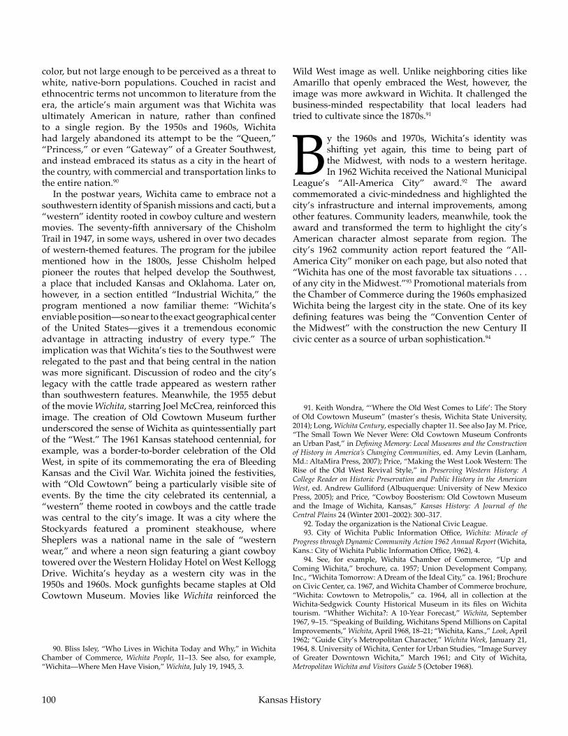
100 Kansas History
color, but not large enough to be perceived as a threat to white, native-born populations. Couched in racist and ethnocentric terms not uncommon to literature from the era, the article’s main argument was that Wichita was ultimately American in nature, rather than confined to a single region. By the 1950s and 1960s, Wichita had largely abandoned its attempt to be the “Queen,” “Princess,” or even “Gateway” of a Greater Southwest, and instead embraced its status as a city in the heart of the country, with commercial and transportation links to the entire nation.90
In the postwar years, Wichita came to embrace not a southwestern identity of Spanish missions and cacti, but a “western” identity rooted in cowboy culture and western movies. The seventy-fifth anniversary of the Chisholm Trail in 1947, in some ways, ushered in over two decades of western-themed features. The program for the jubilee mentioned how in the 1800s, Jesse Chisholm helped pioneer the routes that helped develop the Southwest, a place that included Kansas and Oklahoma. Later on, however, in a section entitled “Industrial Wichita,” the program mentioned a now familiar theme: “Wichita’s enviable position—so near to the exact geographical center of the United States—gives it a tremendous economic advantage in attracting industry of every type.” The implication was that Wichita’s ties to the Southwest were relegated to the past and that being central in the nation was more significant. Discussion of rodeo and the city’s legacy with the cattle trade appeared as western rather than southwestern features. Meanwhile, the 1955 debut of the movie Wichita, starring Joel McCrea, reinforced this image. The creation of Old Cowtown Museum further underscored the sense of Wichita as quintessentially part of the “West.” The 1961 Kansas statehood centennial, for example, was a border-to-border celebration of the Old West, in spite of its commemorating the era of Bleeding Kansas and the Civil War. Wichita joined the festivities, with “Old Cowtown” being a particularly visible site of events. By the time the city celebrated its centennial, a “western” theme rooted in cowboys and the cattle trade was central to the city’s image. It was a city where the Stockyards featured a prominent steakhouse, where Sheplers was a national name in the sale of “western wear,” and where a neon sign featuring a giant cowboy towered over the Western Holiday Hotel on West Kellogg Drive. Wichita’s heyday as a western city was in the 1950s and 1960s. Mock gunfights became staples at Old Cowtown Museum. Movies like Wichita reinforced the
Wild West image as well. Unlike neighboring cities like Amarillo that openly embraced the West, however, the image was more awkward in Wichita. It challenged the business-minded respectability that local leaders had tried to cultivate since the 1870s.91
By the 1960s and 1970s, Wichita’s identity was shifting yet again, this time to being part of the Midwest, with nods to a western heritage. In 1962 Wichita received the National Municipal
League’s “All-America City” award.92 The award commemorated a civic-mindedness and highlighted the city’s infrastructure and internal improvements, among other features. Community leaders, meanwhile, took the award and transformed the term to highlight the city’s American character almost separate from region. The city’s 1962 community action report featured the “All-America City” moniker on each page, but also noted that “Wichita has one of the most favorable tax situations . . . of any city in the Midwest.”93 Promotional materials from the Chamber of Commerce during the 1960s emphasized Wichita being the largest city in the state. One of its key defining features was being the “Convention Center of the Midwest” with the construction the new Century II civic center as a source of urban sophistication.94
91. Keith Wondra, “‘Where the Old West Comes to Life’: The Story of Old Cowtown Museum” (master’s thesis, Wichita State University, 2014); Long, Wichita Century, especially chapter 11. See also Jay M. Price, “The Small Town We Never Were: Old Cowtown Museum Confronts an Urban Past,” in Defining Memory: Local Museums and the Construction of History in America’s Changing Communities, ed. Amy Levin (Lanham, Md.: AltaMira Press, 2007); Price, “Making the West Look Western: The Rise of the Old West Revival Style,” in Preserving Western History: A College Reader on Historic Preservation and Public History in the American West, ed. Andrew Gulliford (Albuquerque: University of New Mexico Press, 2005); and Price, “Cowboy Boosterism: Old Cowtown Museum and the Image of Wichita, Kansas,” Kansas History: A Journal of the Central Plains 24 (Winter 2001–2002): 300–317.
92. Today the organization is the National Civic League.93. City of Wichita Public Information Office, Wichita: Miracle of
Progress through Dynamic Community Action 1962 Annual Report (Wichita, Kans.: City of Wichita Public Information Office, 1962), 4.
94. See, for example, Wichita Chamber of Commerce, “Up and Coming Wichita,” brochure, ca. 1957; Union Development Company, Inc., “Wichita Tomorrow: A Dream of the Ideal City,” ca. 1961; Brochure on Civic Center, ca. 1967, and Wichita Chamber of Commerce brochure, “Wichita: Cowtown to Metropolis,” ca. 1964, all in collection at the Wichita-Sedgwick County Historical Museum in its files on Wichita tourism. “Whither Wichita?: A 10-Year Forecast,” Wichita, September 1967, 9–15. “Speaking of Building, Wichitans Spend Millions on Capital Improvements,” Wichita, April 1968, 18–21; “Wichita, Kans.,” Look, April 1962; “Guide City’s Metropolitan Character,” Wichita Week, January 21, 1964, 8. University of Wichita, Center for Urban Studies, “Image Survey of Greater Downtown Wichita,” March 1961; and City of Wichita, Metropolitan Wichita and Visitors Guide 5 (October 1968).
90. Bliss Isley, “Who Lives in Wichita Today and Why,” in Wichita Chamber of Commerce, Wichita People, 11–13. See also, for example, “Wichita—Where Men Have Vision,” Wichita, July 19, 1945, 3.

101
In the early twentieth century, Wichita’s regional identity was closely tied to Texas and Oklahoma, the natural markets for Kansas’s oil, wheat, and ranching industries. However, in the 1920s, business interests in Wichita sought a more distinctive regional identity as cities in Oklahoma grew in size and industry. In this advertisement, the Wichita Gas Company foreshadowed future changes in the city’s identity by referring to Wichita as an “air capital” and emphasizing the ready supply of energy available in the city. Courtesy of the Wichita Metro Chamber of Commerce and the Wichita-Sedgwick County Historical Museum.
Peerless Princess of the Southwest

102 Kansas History
In 1969 and 1970, as the city celebrated its centennial, the Chamber of Commerce confirmed Wichita’s position in the middle of the country when it unleashed a new marketing campaign: “Center City, U.S.A.” The phrase paralleled the “Midway, U.S.A.” slogan that the state as a whole had adopted as part of its 1961 Centennial Celebration efforts. Reinforcing Wichita as a city of nationwide importance, it emerged in connection with convention promotion in the late 1960s and coincided with the completion of Century II. One brochure, for example, invited visitors to “gather round in Wichita—Center City, U.S.A. where you can meet in the comfort of one of the nation’s finest Cultural and Civic Centers.”95 Although the phrase highlighted the city’s location, it did not exclude other identities, as in one brochure, “Wichita Is . . . ,” that suggested how western friendliness was part of life in Center City, U.S.A. Although targeted mainly to the convention trade, the phrase became a larger descriptor of Wichita in a variety of contexts, such as airport promotional materials and, in 1977, a report of the United States Commission on Civil Rights on school desegregation that introduced Wichita as “this self-proclaimed ‘Center City, U.S.A.’” That said, the term had at best a limited use and was not a common feature in Wichita magazine even in the early 1970s. The first issue of a new city journal, the Wichitan, which came out in July 1977, also did not adopt the term, with later editions featuring articles and advertisements that referenced Wichita being in the West or Midwest. By the late 1970s, the chamber was already moving toward a new slogan: “Wichita: In The Middle of Things.”96
By the time of its centennial celebration in 1970 and the 1976 bicentennial, Wichita celebrated its ties to the Old West. The Keeper of the Plains, Blackbear Bosin’s
massive sculpture that depicted a stylized Plains Indian, was emerging as a new city symbol, one that tied the community to its American Indian heritage. Bosin was from Oklahoma and of Kiowa and Comanche background. His statue depicted a man in a feathered headdress, representing a person of the plains who, presumably, hunted bison instead of making pots and lived in a tipi or grass lodge, not a pueblo. Meanwhile, the gunfights and saloon girls at Old Cowtown Museum reinforced ties to the Old West, while Sheplers had a national reputation for selling western wear.97 In other cases, Wichita celebrated its prominence as a hub for certain industries such as aviation. However, the sense of being the capital of an empire was gone, replaced by a sense of being a modest regional center for the state, not the southern plains. For example, during the city’s 1969 centennial events, the Wichita Eagle-Beacon ran a series of commentaries about the city. Richard Long’s Wichita Century made passing references to the plains, prairies, and the frontier, but the southwestern identity that had once been so prominent was absent. Even “Center City” images, with allusions to being a national crossroads, were giving way to more regional emphases that highlighted being part of the West, Midwest, or Great Plains, but not the Southwest.98
In local history circles, authors such as Craig Miner emphasized a Great Plains or prairie identity for the city. In particular, Marshall Murdock’s “Peerless Princess of the Plains” moniker became one of the city’s popular monikers, one that seemingly confirmed a Midwest connection that had supposedly been there all along. The parallel “Peerless Princess of the Southwest” had faded into obscurity. A prominent example was Peerless Princess of the Plains: Postcard Views of Early Wichita, which came out in 1976. Other works reinforced a “prairie,” “plains,” or “Midwest” identity as well. Among them was, for example, Prairie Portrait, a depiction of Kansas based on photographs from the Wichita Eagle-Beacon, in which authors Forrest Hintz and John Avery concluded their introductory piece with “welcome to the Heartland.”9995. Wichita Area Chamber of Commerce, Center City USA brochure, ca. 1970.
96. One image depicted a hostess with a Center City USA sweatshirt in the “Anatomy of a Convention” article in the September–October 1968 edition of Wichita on page 12. “Report on Tourism in the 1969 Annual Report,” Wichita, January–February 1970, 21; Kenneth E. Johnson, “Birthday Celebration for a City,” Wichita, July–August 1969, 6, and advertisement for official Wichitan Centennial Envelope, Wichita, July–August 1969, 21; President’s Message in 1970 Annual Report, Wichita, January–February 1971, 13. See also Carol Schmidt, “‘Center City, USA,’ Lures Major Conventions Away From The Giants,” Association and Society Manager (October/November 1977), reprint, Wichita Area Chamber of Commerce, “Wichita,” color brochure (ca. 1970); ___, “The Good Life in Wichita,” brochure (ca. 1970); ___, “Guided Tours Center City USA,” booklets for 1970 and 1971; and ___, “Wichita Is . . .” brochure (ca. 1971), all in collection at the Wichita-Sedgwick County Historical Museum in its files on Wichita tourism. Wichita, July–August 1976; The Wichitan (July 1977); Wichita Airport Authority, “Wichita Mid-Continent,” booklet (ca. 1976); United States Commission on Civil Rights, School Desegregation in Wichita, Kansas (Washington, D.C.: United States Commission on Civil Rights, 1977), 1.
97. David Simmonds, Blackbear Bosin: Keeper of the Indian Spirit (Newton, Kans.: Carriage Factory Art Gallery, 2012); Margaret Norton, Keeper of the Plains: Blackbear Bosin’s “Great Indian” in Wichita (Oak Park, Ill.: published by author, 2010).
98. For example, the introduction to the 1984 Wichita Convention and Visitors Bureau’s “Welcome to Wichita” guide references how “Wichita retains its early Western hospitality” and “Wichita still has the flavor of the Old West.” See, for example, Dolores Quinlisk, “Wichita Looks at Future With Eager Anticipation,” Jon Roe, “City Fulfills Old ‘Gold Mine’ Vision,” and Arch O’Bryant, “Century II Outdazzles City’s Historic Halls,” all in the special “Forward Wichita” section of the Wichita Eagle and Beacon, June 29, 1969; Long, Wichita Century.
99. Miner, Wichita: The Magic City; Hal Ross, Hal Ottaway, and Jack

103Peerless Princess of the Southwest
Perhaps the most visible symbol of regional identity came in June 1973, when Wichita’s Board of Park Commissioners, which oversaw the city’s airport, renamed the facility Mid-Continent Airport. Mid-Continent was originally the name for an “industrial” airport north of Kansas City. In the 1960s, however, an expansion project converted the facility into the metropolitan area’s main airport. Although it retained the old MCI code after it became the Kansas City International Airport, the Mid-Continent name was now available for use elsewhere. Wichita claimed it. The renaming proposal came from parks board director H. Jay Setter, who argued that Wichita Municipal Airport sounded too small and local. Moreover, Setter was concerned that naming the facility after a person would confuse the traveling public as to where the airport was. The board pointed out the case of Lindbergh Field, which was not in St. Louis, as might be expected, but in San Diego. The parks board was unanimous in the name change. As the Wichita Beacon explained, it was “not bad as airport names go. In fact, it combines both the flair of a cosmopolitan atmosphere with the distinctiveness of a geographical location.” The term “Mid-Continent” can be traced back to the Mid-Continent Airlines that served the Mid-Continent Oil Field, and it once implied a tie to the Greater Southwest. Now, the term referred to a place in the middle of the United States, largely interchangeable with Midwest.100
The midwestern/mid-continental/middle of the country identity was emerging among business names as well. For example, in 1965 entrepreneur Gary Adamson launched a regional commuter airline based out of Wichita that served primarily western Kansas and the Ozarks. Initially called Aviation Services, Inc., in 1969 the board renamed the company, which had become a regional air carrier, Air Midwest. The name change coincided with an expansion of routes to Kansas City, Colorado Springs, and Amarillo. From the 1970s on, a number of local companies adopted names that evoked a midwestern connection. In 1980, for example, a team of doctors out of Wichita incorporated a company that provided diagnostic services
to patients in rural Kansas called Mid-States Ultrasound and Cardiology Services, Inc.101
These business names suggest that this shift in regional identity ran deeper than Chamber of Commerce convention slogans. The table compares the number of businesses whose names began with a particular regional distinction. Businesses whose names implied a region of the city or state such as Southwest Wichita Community Theater or West Side Barber were omitted, as were names of larger national companies, such as Western Union and Southwestern Bell, which was a regional telephone company with a Kansas branch based in Topeka.
Stewart, Peerless Princess of the Plains: Postcard Views of Early Wichita (Wichita, Kans.: Two Rivers Publishing Co., 1976); Forest Hintz and John Avery, Prairie Portrait . . . the Kansas that Was and Is (Wichita, Kans.: Wichita Eagle and Beacon Publishing Co., 1977).
100. H. Jay Setter to Board of Park Commissioners, May 30, 1973; City of Wichita, “Resolution Renaming the Municipal Airport,” June 11, 1973, both in the files of the Wichita Airport Authority; “Airport Renamed: It’s Mid-Continent,” Wichita Eagle, June 12, 1973. Quotation from “Wichita Mid-Continent,” Wichita Beacon, June 13, 1973. Wichita Airport Authority, “Wichita Mid-Continent,” booklet. See also Shortridge, Kansas City and How It Grew, 106.
101. I. E. Quastler, Air Midwest: The First Twenty Years (San Diego: Airline Press of California, 1985), 6–43, especially 39–40. See also Jay M. Price, Dr. James Mershon, and Teddie Barlow, “Echoing off the Heart of the Heartland: The Mid-States Companies, Echocardiography, and Rural Medicine,” Agricultural History 79 (Spring 2005): 127–46.
102. Before going to work for Western Lithograph, Seward was head of the art department for the Southwest Advertising Company.
a Includes related designations such as “Mid-Continent,” “Mid-America/n,” “Midland,” “Mid-States,” and “Midway.”
b Does not include “West.”c 76 of just “Midwest/ern.”
Table 1. Wichita Business Names in City Directories & Phone Books
Year Midwest/erna Southwest/ern Westernb
1888 0 2 51910 4 14 231930 13 24 271954 21 23 271960 24 32 301975 36 21 222004 157c 28 19
Although a crude measurement, this chart points to the fading of “Southwest” as a marker during the twentieth century and the widespread use of “western” as a designation throughout the twentieth century only to be eclipsed by “Midwest.” As the century dawned, far more businesses and institutions were tied to the “Southwest” than the other two regions, Southwest National Bank being one of the better known examples. Starting in the twentieth century, designations emerged such as Western Lithograph, the printing company founded in 1923 that helped launch the career of Coy Avon Seward and later, Blackbear Bosin.102 By the 1970s, names relating to being in the middle of the country grew in popularity. Perhaps

104
After World War II, promotional materials for the city of Wichita increasingly emphasized its central location. This pamphlet touts Wichita’s distance from the coasts, the growth of local industry even after the war, and the job opportunities available in the city: “Good climate . . . plenty of natural resources, power and fuel . . . plenty of stability and potential energy . . . that’s Wichita, city of opportunity in Mid-America.” Courtesy of the Wichita Metro Chamber of Commerce.
Kansas History

105Peerless Princess of the Southwest
the most telling was the Mid-America All-Indian Center, created in 1969 in connection with the city’s centennial celebration and whose early leaders included Blackbear Bosin. Perhaps telling of the shift in regional identity, the promotional booklet that the center published in 1976 was printed by Western Lithograph!103
This designation of “midwestern” has, however, been problematic as well. Terms like “southwestern” and “western” implied youth and energy. Initially, “Mid-Continent” implied a
North America-wide relevance, or at least relevance in the oil industry. By the second half of the twentieth century, however, “Middle West” or “Midwest” was more apt to suggest a picture of rural and even backward life, the opposite of the forward looking, business-minded future that regional leaders wanted to convey. Shortridge noted that by the 1980s, “the Middle West was a nice place to visit occasionally and to reflect upon one’s heritage. It was America’s collective ‘hometown,’ a place with good air, picturesque farm buildings, and unpretentious ‘simple’ people.”104 Although individuals such as Shortridge and Jon Lauck have worked to restore a more positive image to the Midwest, others have asserted that the negative stereotypes are hard to overcome. The region was the butt of jokes from more urbane and sophisticated locales. A wave of works from Robert Smith Bader’s Hayseeds, Moralizers, and Methodists to Richard Longworth’s Caught in the Middle have explored the degree to which the Midwest has become associated with being left behind in global economics, more hinterland than Heartland. Locally, polls have found that Wichita’s residents were often more negative about their community than the rosy depictions in the promotional literature might suggest. “It’s a good place to live but I wouldn’t want to visit there” has been one statement of local perception, while others used the nickname “doo-dah” to refer to this city that was a quiet backwater away from the turbulence of the modern world.105
Even the promotional materials the city published in the 1990s and 2000s hinted at a shift. In the late 1990s, Wichita’s Convention and Visitor’s Bureau put out visitor guides that still evoked a location in the center of the country with “Midwest magic.” After 2000, the bureau’s publications moved away from those themes. The focus, instead, became a three-part emphasis. One facet was as an aviation center, a theme especially prominent in the 2003 centennial of flight commemoration activities. Another theme was of the Old West, complete with a “Western Heritage Tour” launched in 2004. The third image involved entrepreneurship, concentrating on Wichita’s status as a business center that gave rise to Pizza Hut, the Coleman Company, Rent-a-Center and Mentholatum.106
Wichita’s identity remains in flux. Although still a global center of general aviation, the city faced challenges maintaining its “Air Capital” image. This was especially true in the face of large layoffs in the aviation industry during the Great Recession after 2008, and Boeing left altogether in 2014. That same year, construction of a new terminal at the city’s airport resulted in the city council voting to rename the facility Dwight D. Eisenhower National Airport. One major reason was because of the sense that “Mid-Continent” was too limiting and too provincial a designation for a city that still had grand ambitions. A generation earlier, local leaders embraced the “Mid-Continent” designation because of its larger regional associations. Now, it was the sign of a provincialism that leaders found embarrassing.107
Since the 1800s, regional identity in Wichita has been rooted primarily in its leaders’ views of their city’s orientation to the rest of the country. Through the nineteenth century, the city’s orientation was primarily toward Indian Territory and Texas. As such, being “southwestern” implied a regional prominence, a capital of a modest empire that extended to the high plains. As the twentieth century unfolded, however, local promoters gradually refocused their attention to embrace a “Mid-Continent” identity located in the center of the country, a national hub and crossroads whose very location, advocates argued, would almost inevitably result in national, even global prominence. When it became
103. Harriett K. H. Price, From Dreams to Reality: The Birth of the Mid-America All Indian Center and the Lives It Touched (Wichita, Kans.: published by author, 1981); Mid-America All Indian Center, Inc., The Mid-America All Indian Center, Inc. (Wichita, Kans.: MAAIC, 1976); O’Neill and Foreman, The Prairie Print Makers, 12–19.
104. Shortridge, The Middle West, 67–68.105. Ibid., 67–96. See also Robert Smith Bader, Hayseeds, Moralizers, and
Methodists: The Twentieth-Century Image of Kansas (Lawrence: University Press of Kansas, 1988); Richard Longworth, Caught in the Middle: America’s Heartland in the Age of Globalism (New York: Bloomsbury, 2009); Lauck, The Lost Region. See also, for example, Alan Bjerga, “Who Loves Ya, Wichita? Not Wichitans,” Wichita Eagle, September 3, 2000.
106. Wichita Convention and Visitor’s Bureau, official area visitor guides, 1990–2012.
107. Jerry Siebenmark, “Airport’s Official Name Change to Eisenhower Comes Sooner than Planned,” Wichita Eagle, January 8, 2015; Bill Wilson, “Wichita Council Reaffirms Airport Name Change to Eisenhower,” Wichita Eagle, April 8, 2014; ___, “Wichita’s Mid-Continent Airport becomes Dwight D. Eisenhower National with Council’s Backing,” Wichita Eagle, March 4, 2014; Molly McMillin, “End of an Era: Boeing in Final Stages of Leaving Wichita,” Wichita Eagle, July 29, 2014.

106 Kansas History
apparent that merely being “in the middle of it all” did not predestine a city for greatness, Wichita’s promoters looked elsewhere, reviving, for example, a complicated and even contrived connection to the Old West before settling for a time on a more modest “Midwest” that coincided with a chastened, limited sense of importance.
These shifting regional affiliations have sometimes been at odds with larger trends. At the dawn of the twentieth century, when Chicago was a burgeoning hub of commerce and the “Middle West” was a powerful economic and political presence in American life, Wichitans preferred to ally themselves with a more limited set of connections tied to Greater Texas. At the end of the century, people and businesses flocked to opportunities in places such as Phoenix, Albuquerque, Las Vegas, El Paso, and Tucson. Wichita meanwhile had become firmly wedded to being part of the Midwest, a “doo-dah” wrestling with shrinking populations, Rust Belt economic challenges, controversies over social issues such as abortion, and the stigma of being a “flyover” country behind the times.
That said, being on the border of several areas has allowed Wichitans one constant opportunity: the option of redefining its regional identity. Rothman has pointed out that identity can be, indeed, a “devil’s bargain.” Once an identity has been developed and cultivated, communities often find themselves having to play to that identity whether they like it or not, akin to actors condemned to play just one type of role for the rest of their careers. Wichita has not been so constrained. As economic and social forces have dictated, Wichitans have solidly proclaimed themselves as part of the Southwest, only to turn and proclaim with equal vehemence that their central location made them the crossroads of the nation.
Today’s Wichitans, generally, see themselves as part of the Midwest and are often surprised to learn that there was a time when their city was part of the Southwest. At one moment they were an aviation center on the cutting edge of flight technology. At another, they were the colorful holdovers of the Old West. Wichitans have had the luxury of picking the region to which they belong, unaware that this identity may not have “always been there.”
As long as the desert and tri-cultural mix of Arizona–New Mexico remain as the defining image of being southwestern, it is unlikely that Wichita will be able to rejoin this region in the near future. However, connecting to Greater Texas appears possible. A growing Latino population and cultural presence suggests a renewed connection to the Mexico–U.S. borderlands. Once solidly mainline Protestant, the city’s Catholic–Evangelical–Pentecostal populations now define the local religious landscape. The city’s cultural mix is more akin to Oklahoma City and Dallas than St. Louis or Chicago.108 The city still has a legacy connected to Texas, Oklahoma, and beyond, one that might see a new vitality with the
The aviation industry boomed in Wichita during the 1930s and 1940s, giving local promoters the opportunity to advance Wichita on the national stage as a hub in the global economy. Corporations such as Beechcraft manufactured aircraft in Wichita throughout the twentieth century, as shown above.
108. In the early twentieth century, for example, Baptist churches in Wichita were American or Northern Baptist. The first Southern Baptist Congregation, Airlane Baptist, was organized in 1945. A decade later, there were over a dozen Southern Baptist congregations in Wichita. Today, Catholics, Southern Baptists, and Evangelical Protestants are among the largest demographics of the city, and have continued to grow as mainline Protestant groups declined. See, for example, Fred Mann, “Catholics, Mormons See Most Growth in Wichita and Kansas,” Wichita Eagle, May 7, 2012.

107Peerless Princess of the Southwest
upcoming 150th anniversary of the Chisholm Trail, a trade and transportation conduit that parallels today’s I-35 down to the Mexican border.109 Those who support rail travel work to connect Wichita to the Heartland Flyer route that runs between Oklahoma City and Fort Worth. Meanwhile, the recent arrival of Southwest Airlines to
the newly designated Dwight D. Eisenhower National Airport and the appearance of sweet tea in restaurants may hint at the shape that Wichita’s next transformation might take. As mayor Clarence Vollmer once mused, “If you want to know what Wichita is going to be like in about 20 years, just drive to Dallas.”110
109. See, for example, the websites of the Chisholm Trail Heritage Center, https://onthechisholmtrail.com/; the International Chisholm Trail Association, http://chisholmtrailassn.org/celebrations-cattle-trail-events; and the Chisholm Trail 150th Celebration, http://chisholmtrail150.org/.
Wichita’s airport received a new name after a significant expansion in the 1960s, reflecting changes in the city’s regional and national aspirations. The Wichita Municipal Airport became the Mid-Continent Airport in 1973 after parks board director H. Jay Setter argued that the airport’s name should reflect Wichita’s central place in the nation rather than its ties to the local community.
110. Mayor’s quotation from “Whither Wichita?,” Wichita, September 1967.