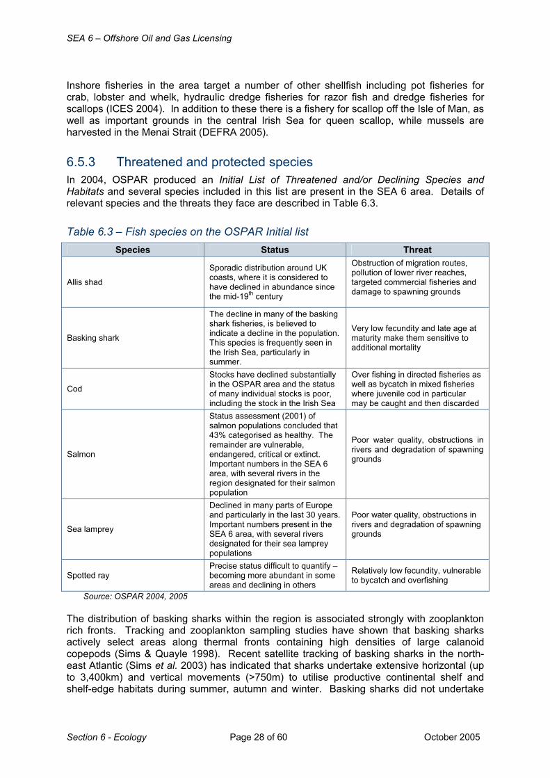
6 ECOLOGY 6.1 Regional overview - GOV.UK
60
SEA 6 – Offshore Oil and Gas Licensing October 2005 Page 1 of 60 Section 6 - Ecology 6 ECOLOGY 6.1 Regional overview The SEA 6 area is a biologically productive region which supports a wide range of biological organisms and ecosystems. The extent of this productivity is determined by the distribution and variety of coastal and marine habitats; hydrological and meteorological conditions; and by human exploitation and disturbance (both historic and ongoing). For example, the extent of freshwater and oceanic inflow to the region is a strong determinant of the nature of planktonic communities. Plankton production is particularly high in coastal areas of the eastern Irish Sea (e.g. Morecambe Bay, Solway Firth and the Mersey and Dee estuaries) due to nutrient recharge from coastal rivers throughout the spring and summer. Offshore regions are less productive although frontal areas between stratified and mixed waters may be areas of enhanced production. Fish communities are generally well described with distinct assemblages associated with different seabed substrates. Sandy inshore areas support large numbers of juvenile flatfish and sand eels, with seasonal populations of sprat, herring and juvenile gadoids. Rockier areas are dominated by small species such as wrasse, gobies and blennies, as well as juvenile pollock and saithe. Pelagic fish such as mackerel and herring range widely within the region, migrating between summer feeding grounds, spawning grounds and over- wintering grounds. Seabed substrates and exposure to currents and waves are also important in determining the benthic communities present. Coastal benthic communities are diverse with areas such as estuaries supporting considerable benthic biomass (and associated predator populations e.g. fish and waterbirds). Offshore areas are relatively well studied although information on benthic communities is often of a broadscale nature. The region supports a number of benthic species and habitats of conservation interest (e.g. biogenic reefs of the horse mussel, Modiolus modiolus), the distribution and abundance of which were surveyed as part of SEA 6. Muddy areas particularly to the east and west of the Isle of Man support important Nephrops fishing grounds with scallop and queen scallop found on gravelly substrates. The SEA 6 area may be important seasonally for leatherback turtles which visit the region over the summer. Research is currently underway to better understand the distribution and abundance of leatherbacks and their jellyfish prey within the Irish Sea. During spring and summer months, the SEA 6 area supports almost half a million pairs of breeding seabirds at locations including Skomer, Skokholm, Ailsa Craig, Morecambe Bay and the Ribble and Alt estuaries. Species occurring in large numbers include Manx shearwater, gannet, lesser black-backed gull, guillemot and herring gull with coastal and offshore waters important for feeding and overwintering birds. Waterbirds breed at estuarine sites along the SEA 6 coastline with many sites including the Dyfi, Dee, Mersey, Ribble and Alt estuaries, Morecambe Bay, Duddon Estuary, Belfast Lough, Stangford Lough and the Solway Firth also important for wintering or migratory waterbird species. The waters of Liverpool and Cardigan Bays are of great importance to wintering common scoter and divers. Harbour porpoise and bottlenose dolphin are present within the region throughout the year while others are more commonly seen in summer months (e.g. minke whale, Risso’s dolphin and short-beaked common dolphin). In general, southern areas of the Irish Sea are more important for cetacean species with coastal waters of Cardigan Bay supporting a bottlenose
Transcript of 6 ECOLOGY 6.1 Regional overview - GOV.UK

SEA 6 – Offshore Oil and Gas Licensing
October 2005 Page 1 of 60 Section 6 - Ecology
6 ECOLOGY
6.1 Regional overview The SEA 6 area is a biologically productive region which supports a wide range of biological organisms and ecosystems. The extent of this productivity is determined by the distribution and variety of coastal and marine habitats; hydrological and meteorological conditions; and by human exploitation and disturbance (both historic and ongoing). For example, the extent of freshwater and oceanic inflow to the region is a strong determinant of the nature of planktonic communities. Plankton production is particularly high in coastal areas of the eastern Irish Sea (e.g. Morecambe Bay, Solway Firth and the Mersey and Dee estuaries) due to nutrient recharge from coastal rivers throughout the spring and summer. Offshore regions are less productive although frontal areas between stratified and mixed waters may be areas of enhanced production. Fish communities are generally well described with distinct assemblages associated with different seabed substrates. Sandy inshore areas support large numbers of juvenile flatfish and sand eels, with seasonal populations of sprat, herring and juvenile gadoids. Rockier areas are dominated by small species such as wrasse, gobies and blennies, as well as juvenile pollock and saithe. Pelagic fish such as mackerel and herring range widely within the region, migrating between summer feeding grounds, spawning grounds and over-wintering grounds. Seabed substrates and exposure to currents and waves are also important in determining the benthic communities present. Coastal benthic communities are diverse with areas such as estuaries supporting considerable benthic biomass (and associated predator populations e.g. fish and waterbirds). Offshore areas are relatively well studied although information on benthic communities is often of a broadscale nature. The region supports a number of benthic species and habitats of conservation interest (e.g. biogenic reefs of the horse mussel, Modiolus modiolus), the distribution and abundance of which were surveyed as part of SEA 6. Muddy areas particularly to the east and west of the Isle of Man support important Nephrops fishing grounds with scallop and queen scallop found on gravelly substrates. The SEA 6 area may be important seasonally for leatherback turtles which visit the region over the summer. Research is currently underway to better understand the distribution and abundance of leatherbacks and their jellyfish prey within the Irish Sea. During spring and summer months, the SEA 6 area supports almost half a million pairs of breeding seabirds at locations including Skomer, Skokholm, Ailsa Craig, Morecambe Bay and the Ribble and Alt estuaries. Species occurring in large numbers include Manx shearwater, gannet, lesser black-backed gull, guillemot and herring gull with coastal and offshore waters important for feeding and overwintering birds. Waterbirds breed at estuarine sites along the SEA 6 coastline with many sites including the Dyfi, Dee, Mersey, Ribble and Alt estuaries, Morecambe Bay, Duddon Estuary, Belfast Lough, Stangford Lough and the Solway Firth also important for wintering or migratory waterbird species. The waters of Liverpool and Cardigan Bays are of great importance to wintering common scoter and divers. Harbour porpoise and bottlenose dolphin are present within the region throughout the year while others are more commonly seen in summer months (e.g. minke whale, Risso’s dolphin and short-beaked common dolphin). In general, southern areas of the Irish Sea are more important for cetacean species with coastal waters of Cardigan Bay supporting a bottlenose

SEA 6 – Offshore Oil and Gas Licensing
Section 6 - Ecology Page 2 of 60 October 2005
dolphin population of about 220 individuals and harbour porpoise also numerous along the Welsh coast. A relatively small population of grey seals utilise all but the north-west Irish Sea while harbour seals are found primarily in the far north of the area.
6.2 Plankton
6.2.1 Data sources A review of plankton ecology in the SEA 6 area was commissioned from the Port Erin Marine Laboratory (PEML) (Kennington & Rowlands 2005). The review was based on data provided by the Continuous Plankton Recorder (CPR) survey, regional surveys and scientific literature. CPR coverage (Figure 6.1a) is limited in the northern Irish Sea (Reid et al. 2005). However, a number of relevant survey stations and transects have been operated by PEML and the Environment Agency (Figure 6.1b).
Figure 6.1 – Irish Sea plankton stations and surveys
Notes: CPR – Continuous Plankton Recorder, PEML – Port Erin Marine Laboratory, EA – Environment Agency, WISPER – Western Irish Sea Zooplankton Survey. Source: Kennington & Rowlands (2005)
Plankton is a general term which covers a wide range of free-floating plants (phytoplankton) and animals (zooplankton). They form the base of most trophic interactions within the marine environment and changes in their distribution and abundance have important consequences for higher trophic levels. Due to their limited mobility, plankton distribution and abundance is strongly influenced by hydrographic factors such as depth, tidal mixing, temperature stratification and currents (Boelens et al. 1999).

SEA 6 – Offshore Oil and Gas Licensing
October 2005 Page 3 of 60 Section 6 - Ecology
6.2.2 Phytoplankton Phytoplankton are responsible for most of the primary production in the sea and consist of larger entities such as diatoms and dinoflagellates (15-400µm in size), and smaller flagellates. Smaller flagellates make up part of the nanoplankton (organisms 2-20µm in diameter) and picoplankton (0.2-2µm in diameter), along with bacteria, fungi and a number of the smallest diatoms and dinoflagellates. These are thought to make a considerable contribution to primary production, and act as an important food source for many larvae (Tait 1992, Mandali de Figueiredo 2003). Phytoplankton production The physical and biological dynamics of seasonal phytoplankton production have been described in previous SEAs. Briefly, the main features include:
• Diatom bloom with the onset of spring stratification. • Silicate (essential for diatom growth) becomes limited and other groups such as
flagellates bloom, followed later by dinoflagellates. • Further nutrient depletion causes primary production to slow. • Autumn introduces stronger winds which mix the water, introducing nutrients back to
the photic zone, which may initiate a smaller secondary bloom of dinoflagellates. • With little primary production during winter, further mixing causes nutrient
concentrations to rise to levels which support the spring bloom.
Figure 6.2 – Phytoplankton production Notes: Average water column chlorophyll data recorded at (a) the Cypris station (µg/litre) 1966-2002 and (b) the Continuous Plankton Recorder’s (CPR) phytoplankton colour index produced for the Irish Sea between 1970 and 2002. Both data sets are based on average monthly values. Thickened contour line in Cypris plot indicates the 1.5µg/litre contour boundary. Source: Kennington & Rowlands (2005). Figure 6.2a shows chlorophyll concentrations (monthly averaged - a proxy measurement of phytoplankton biomass) measured at the Cypris station (see Figure 6.1b for location) between 1966 and 2002. The major period of phytoplankton production has
been taken as the period through the spring and summer where chlorophyll values are higher than 1.5µg/l and this boundary has been highlighted on the contour plot. The duration of the spring/summer phytoplankton bloom appears to have lengthened during the late 1980s to mid to late 1990s. In addition, the intensity of the spring bloom appears to have increased over the same period. There is also considerable variation in the timing of the spring bloom (Kennington & Rowlands 2005).

SEA 6 – Offshore Oil and Gas Licensing
Section 6 - Ecology Page 4 of 60 October 2005
Figure 6.2b displays the average monthly phytoplankton colour index (corresponds to overall phytoplankton abundance) derived from CPR data between 1970 and 2001. The number of months the colour index reads 0.5 or more has steadily increased since the 1990s suggesting an increase in length of the phytoplankton production period. Generally, phytoplankton abundance appears to be increasing in both the Irish Sea and other UK and Irish waters (Figure 6.3). Long-term signals in phytoplankton biomass and phytoplankton community shifts have been correlated with sea surface temperatures, Northern Hemisphere Temperature Anomaly and changes in the North Atlantic Oscillation (NAO) index (Edwards et al. 2001, Beaugrand & Reid 2003).
Figure 6.3 – Annual mean phytoplankton colour in UK waters
Source: Reid et al. (2005).
Regional variation Chlorophyll concentrations in inshore waters of the eastern Irish Sea, particularly in estuarine environments such as Morecambe Bay (Scenario areas 4 & 5), the Solway Firth (adjoins area 3) and the Mersey-Dee confluence (areas 5 & 7) can reach above 50µg/l. Such areas tend to have higher chlorophyll concentrations throughout the production season owing to nutrient recharge from river discharges leading to concerns over the potential for eutrophication (OSPAR 2002). Spring bloom chlorophyll concentrations in more saline waters of the eastern Irish Sea tend to be in the region of 5-15µg/l. Coastal waters of the western Irish Sea (Scenario area 3) tend to have spring chlorophyll values of 15-25µg/l, whilst offshore waters in the western Irish Sea tend not to exceed 15µg/l (Gowen & Bloomfield 1996). In the western Irish Sea the spring bloom develops between March and May, and by June the phytoplankton populations begin to decline. By this time the western central Irish Sea develops a strong thermocline associated with the development of the western Irish Sea gyre. After stratification has been established, nutrients are soon consumed by the

SEA 6 – Offshore Oil and Gas Licensing
October 2005 Page 5 of 60 Section 6 - Ecology
phytoplankton and greater phytoplankton biomass is found at depth where there is nutrient exchange across the pycnocline (Kennington & Rowlands 2005).
Figure 6.4 – Phytoplankton variation in the Irish Sea Source: K Kennington, personal communication. Distinct regions (typologies) have been identified in the Irish Sea (Figure 6.4 and Table 6.1) with different hydrography, nutrient chemistry, primary production etc.
Table 6.1 – Irish Sea typologies and associated scenario areas
Typology Scenario areas
Water type Phytoplankton
A Regions of freshwater input
Adjoins 3, 4, 5, 7
Low salinity, non-thermally stratified, mixed waters with high winter nutrients. Includes embayments and inshore waters such as Belfast, Carlingford and Strangford Loughs, Morecambe Bay, Solway Firth and south-east Liverpool Bay.
Phytoplankton growth season (6-7 months). Diatoms abundant throughout growth season. Dinoflagellates peak during late summer. Spring and summer peak in nanoflagellates.
B Coastal frontal zones
All
Salinities (30-33‰), moderately high winter nutrients. Waters generally well mixed, haline stratification can occur during high river run-off (e.g. salinity front in Liverpool Bay and coastal tidal mixing fronts).
Phytoplankton growth season (5 to 6 months), with spring diatom peak. Dinoflagellate and nanoflagellate dynamics similar to A.
C Offshore mixed waters
All
High salinity (>34‰), moderate winter nutrients. Waters generally well mixed, weak thermocline can develop during extended fine weather.
Short production season (3-4 months). Spring peak in all algal groups. Nanoflagellate peak in summer.
D
Offshore waters of transitional stability
3, 4, 6, 7
Moderately high salinity (>33‰) and winter nutrients. Weak or intermittent stratification (e.g. central eastern Irish Sea and around western Irish Sea gyre).
Phytoplankton season similar to C, although algal groups generally more abundant. Nanoflagellate dynamics similar to C.

SEA 6 – Offshore Oil and Gas Licensing
Section 6 - Ecology Page 6 of 60 October 2005
Typology Scenario areas Water type Phytoplankton
E
Offshore seasonally stratified waters
3
High salinity, moderate winter nutrients. Waters thermally stratified during summer months (e.g. waters within western Irish Sea gyre).
Length of the phytoplankton season varies considerably as does seasonal phytoplankton abundance.
Source: Kennington & Rowlands 2005
6.2.3 Zooplankton The zooplankton consists of a wide variety of planktonic animals and can be divided into holoplankton and meroplankton. The holoplankton consists of permanent members of the plankton where all developmental stages are retained in the plankton whilst the meroplankton are temporary members where only some developmental stages are within the plankton, such as the eggs or larvae (Kennington & Rowlands 2005). Zooplankton communities The most abundant zooplankton are copepods, small crustaceans ranging in size from 0.5-6.0mm. These generally feed on phytoplankton and are themselves the main food source for many organisms higher in the food chain such as larval and juvenile fish. Information from the western Irish Sea zooplankton survey (WISPER, see Figure 6.1b for survey location) indicates that copepods constitute almost 70% of the zooplankton with smaller species (e.g. Pseudocalanus elongatus, Temora longicornis and Acartia clausi) dominating (Kennington & Rowlands 2005). Other species such as Calanus helgolandicus and C. finmarchicus were much less abundant. A similar population pattern is reflected in other areas of the Irish Sea such as the North Channel (Gowen et al. 1998) and the eastern Irish Sea (Graziano 1988). This species composition is in marked contrast to that of offshore areas of the UKCS, where the larger Calanus species predominate. Crustacean decapod larvae (e.g. crabs, shrimps etc) are an important seasonal element of the meroplankton constituting about 9% of the zooplankton in the western Irish Sea survey. The larval forms of other benthic organisms including cirripedes (barnacles), echinoderms (urchins, starfish) and gastropod molluscs were present at lower levels (1-2%). Other elements of the zooplankton include fish eggs and larvae, chaetognaths (arrow worms) as well as a range of gelatinous zooplankton including larvaceans, salps, doliolods, ctenophores and coelenterates. Distribution and dynamics General copepod distributions in the Irish Sea show a consistent pattern of elevated numbers west of the Isle of Man (Figure 6.5). The western Irish Sea gyre has been shown to retain organisms within this region (e.g. Hill et al. 1994, Hill et al. 1996, Dickey-Collas et al. 1997, Gowen et al. 1997) and could be one reason for the elevated copepod abundances. The copepods Acartia clausi and T. longicornis were also relatively abundant in the nutrient rich, low salinity, phytoplankton rich waters at the mouth of Morecambe Bay. The larger Calanus species whilst relatively low in abundance are important as prey items for larger fish larvae (Nash & Geffen 2004). In general, the warmer water C. helgolandicus is more abundant than the cold temperate water C. finmarchicus though both species show considerable spatial and temporal inter-annual variability in abundance (Gowen et al. 1997)

SEA 6 – Offshore Oil and Gas Licensing
October 2005 Page 7 of 60 Section 6 - Ecology
which may be linked to the North Atlantic Oscillation (Beaugrand et al. 2003, Nash & Geffen 2004).
Figure 6.5 – Distributions of main copepod species in the Irish Sea
Note: Main copepod species include a) Pseudo/Paracalanus spp., b) Acartia spp. and c) T. longicornis. CPR data taken from 1971 to 2001. Note extrapolation of data to north-eastern Irish Sea where no CPR sample points were taken. Source: Kennington & Rowlands (2005)
Decapod larvae are abundant throughout the Irish Sea with maximum abundances found in the Morecambe Bay area. The larvae show a large peak in abundance from June to August (Graziano 1988) although there has been a steady decline in larval numbers since the 1970s (Kennington & Rowlands 2005). Numbers of Nephrops larvae are greatest in the western Irish Sea (White et al. 1988, Dickey-Collas et al. 2000) probably as a result of the adults being confined to muddy substrates. In general, areas to the west of the Isle of Man and around Morecambe Bay are important in terms of zooplankton abundance. As well as the zooplankton groups and species mentioned above, other groups with distributions centred on these areas include cladocerans, cirripedes, larvaceans and chaetognaths. Those with more coastal distributions include mollusc and echinoderm larvae (Kennington & Rowlands 2005).
6.2.4 Other issues The SEA 6 assessment workshop identified the following issues: Oil pollution Studies of oil pollution have shown that different phytoplankton species have different sensitivities to crude oil. It has also been noted that low levels of oil pollution can actually enhance primary production (Kelly 1999). Following the Sea Empress oil spill, no marked changes in the major phytoplankton or zooplankton species occurred (Batten et al. 1998). However, barnacle larvae were not seen post spill indicating that the zooplanktonic community may have shown a population shift from the previous year (Kennington & Rowlands 2005). Given the importance of planktonic larvae in repopulating areas following large scale losses of benthic organisms (as seen following the Sea Empress spill, see Section 5.5.3); further information on their sensitivity to hydrocarbons would be valuable in determining recovery timescales and dynamics.

SEA 6 – Offshore Oil and Gas Licensing
Section 6 - Ecology Page 8 of 60 October 2005
Planktonic cysts The most common and abundant group of encysting organisms are the dinoflagellates and in the Irish Sea over 45 dinoflagellate cyst taxa have been identified (Marret & Scourse 2002). Dinoflagellates form cysts during either adverse environmental conditions or following sexual reproduction. These cysts sink to the seabed and tend to be concentrated in fine rather than coarse sediments. They can be transported a considerable distance by water currents, especially during winter storms (Marret & Scourse 2002). More information on the distribution of these cysts could assist tracking the potential for harmful algal blooms (cysts of the genus Alexandrium, associated with paralytic shellfish poisoning (PSP) have been observed in the Irish Sea (Marret & Scourse 2002)) and/or exceptional blooms which cause nuisance/eutrophication events. Further, the introduction of new marine species from ballast waters has increased and is now thought to be responsible for about 20% of all new species introduced to the marine environment in Britain (Kennington & Rowlands 2005). Many of these invasive species travel as cysts in ballast water tanks. Information on the distribution of these cysts following introduction would allow a more targeted response. The issue of ballast water and invasive species has been described in previous SEA consultation documents.
6.2.5 Relevant data gaps The previous section identified other issues of relevance to plankton communities in the SEA area for which more information is required. However, these do not represent significant data gaps in terms of the strategic assessment as long-term monitoring of Irish Sea plankton dynamics by the CPR and other research agencies (e.g. PEML) have provided a solid information base on which to judge the effects of licensing. The large degree of inter-annual variability can make it difficult to separate natural and anthropogenic effects although most effects of oil and gas activities on planktonic communities are likely to be short-lived and local in nature.
6.3 Benthos
6.3.1 Data sources The Irish Sea is one of the best and longest studied marine environments in the UK. The area includes a complex range of intertidal and seabed habitats and the associated benthic fauna are correspondingly varied. To support the SEA 6 process a variety of reports and survey work were commissioned including:
• A synthesis of current information on the benthic environment and the benthic communities and associations of the SEA 6 area (Wilding et al. 2005a).
• A synthesis of information on the benthos of SEA 6 Clyde Sea area (Wilding et al. 2005b).
• Survey report assessing the status of horse mussel beds in the Irish Sea off north-west Anglesey (Rees 2005).
• Survey report detailing the distribution and extent of methane-derived authigenic carbonate within the SEA 6 area (Judd 2005).
The SEA 6 supporting documents provide a synopsis of the historical and current status of benthos and rare species/communities within the SEA 6 area, and have been used as the basis for this section. Additional material has also been researched and included within this

SEA 6 – Offshore Oil and Gas Licensing
October 2005 Page 9 of 60 Section 6 - Ecology
section to complement that produced for the SEA 6 area. These additional sources of information include:
• A variety of survey work commissioned by oil and gas operators, including broadscale seabed surveys and drilling surveys in the vicinity of the Isle of Man and pre and post development surveys of oil and gas facilities in the Liverpool Bay area.
• BIOMÔR reports 1 and 2, benthic biodiversity studies in the southern and south-west Irish Sea.
• Outputs from the Irish Sea Study Group, in particular the Irish Sea environmental review.
• A directory of seabed camera studies in the Irish Sea (Allen & Rees 1999) • Reports detailing rare species/communities including scientific papers detailing
Limaria hians presence within the SEA 6 area and the atlas of marine Biodiversity Action Plan produced for the Countryside Council for Wales.
• CCW intertidal habitat mapping studies (HabMap – see section 7.4.4)
6.3.2 Benthic communities Benthic communities are traditionally considered and presented as three faunal groups: meiofauna, infauna and epifauna (together with algae, which can be split into macro- and microalgae). The meiofaunal group, the smallest in size (less than 0.5mm), are generally capable of moving between the sediment particles using the natural spaces. Though these animals can be found in very high numbers, they have not been extensively surveyed because of their microscopic size. The macrofaunal group (greater than 0.5mm) are usually surveyed using grabs or corers, as most species live in the upper layers of the sediment. They represent the most commonly surveyed and well-known benthic grouping. Larger organisms which live on and within the seabed sediments are known as megafauna. Large burrowing organisms are ecologically important as their deep burrows structure the sediment habitat available to smaller species and also provide habitats for commensal species. Burrowing activities also oxygenate the sediments and may redistribute contaminants. Epifaunal animals, which live on the surface of the substrate, are generally larger in size than infauna. They may be encrusting or sessile (usually on rocky substrates), such as sponges and anemones; or mobile and sometimes capable of extensive migrations both over the seabed and in the water column, e.g. some crustaceans.
6.3.3 Inshore waters Inshore waters of the Irish Sea, including littoral areas, occupy the largest spatial area within SEA 6. For the purpose of this assessment the inshore waters of SEA 6 have been assessed in relation to the seven DTI scenario areas. This area extends along the west coast of Wales from the Lleyn Peninsula in the north, to Milford Haven in the south (Figure 6.6). Seabed sediments are characterised by sandy gravel and gravel. The Lleyn Peninsula littoral environment is predominantly exposed and with typical wave/tide exposed biological communities (Rostron 1984). Four beach assemblages have been described on the Lleyn Peninsula by Hiscock (1998), each largely determined by the degree of exposure. These four groups include very unstable beaches supporting sparse populations of the isopod Eurydice pulchra and the amphipods Bathyporeia pelagica and Haustorius arenarius grading to unstable beaches that additionally host the polychaetes Paraonis fulgens, Ophelia rathkei and Scolelepis squamata. Stable or very stable beaches contain a more diverse community with polychaetes such as Lanice conchilega, Scoloplos armiger, Arenicola marina, Clymene oerstedii and Pygospio elegans and molluscs including Cerastoderma edule and Angulus tenuis.

SEA 6 – Offshore Oil and Gas Licensing
Section 6 - Ecology Page 10 of 60 October 2005
Scenario area 1 Figure 6.6 – Coastal benthic communities in Scenario area 1
Further south in Cardigan Bay, sediments are primarily sandy in nature. Within Cardigan Bay there are three principal estuaries, the Dyfi, Barmouth and the Glaslyn/Dwyryd systems. The Dyfi estuary fauna is of low diversity with the amphipod Corophium and the bivalve Macoma (Mills 1998a), whilst the Glaslyn/Dwyryd system supports characteristic sand beach species such as Bathyporeia spp., H. arenarius and A. tenuis. Transitional zones, which are exposed to reduced salinity, typically host large communities of Corophium volutator and the bivalves Mya arenaria and Scrobicularia plana. The beaches around Aberystwyth are predominantly coarse consisting of ‘clean’, unstable gravel sustaining low species diversity and abundance. However, one species recorded in this unstable intertidal zone is the amphipod Pectenogammarus planicrurus (Bell 1995). The Cardigan Bay area has several saline lagoons and surveys have identified nine species specific to these habitats: the polychaete Alkmaria romijni; molluscs Cerastoderma glaucum and Ventrosia ventrosa; crustaceans Gammarus chevreuxi, Idotea chelipes and Lekanesphaera hookeri; the bryozoan Conopeum seuratii and algae Chaetomorpha linum and Ruppia maritima. The sublittoral environment of Cardigan Bay is primarily sedimentary consisting of sands in the south to large glacial features, sarns, towards the north. These sarns consist of long (>10km), narrow ridges of poorly sorted glacial outwash and moraine, frequently 6-8m in height and up to 500m across, they are occasionally exposed during low spring tides. As a consequence, the associated biota is somewhat ephemeral in nature (Hiscock 1986). Sarn crests sustain communities of the algae Chorda filum and Laminaria digitata, L. saccharina and Halidrys siliquosa and their epiphytes in deeper water. Sands between the sarns host numerous echinoderms such as Astropecten irregularis, Ophiura ophiura, Echinocardium

SEA 6 – Offshore Oil and Gas Licensing
October 2005 Page 11 of 60 Section 6 - Ecology
cordatum and Labidoplax digitata (Hiscock 1986). Ellis and Rogers (2000) also recorded A. irregularis, Asterias rubens and O. ophiura from the bay. The southern reaches of this scenario area are exposed to the prevailing south-westerly winds and consequently most of the coastline is exposed or very exposed, the one exception being Milford Haven which is very sheltered, although with strong tidal currents in places (Powell et al. 1979). Nearshore sediments in the area are generally of a coarse nature, composed of gravel and sand, although the substratum around Skomer to Strumble Head is rock based. This area supports several species that are present at the limits of their distribution, including the brown algae Bifurcaria bifurcata, the molluscs Monodonta lineata and Patella depressa, the barnacle Balanus perforatus and the cup coral Balanophyllia regia (Powell et al. 1979). Hiscock (1983) observed a rich flora and fauna in the region, but no specifically unusual communities. Later survey work of tide swept regions of north Wales and Pembroke by Moore (2004) noted the presence of five species that are considered scarce or rare. These species were the sponges Axinella damicornis and Tethyspira spinosa, the sea squirts Pycnoclavella aurilucens and Polysyncraton lacazei and the brown seaweed Carpomitra costata. Other rarities found in this region include the Pink Sea Fan Eunicella verrucosa (The UK Biodiversity Group and English Nature 1998-9b) and the yellow trumpet anemone (Parazoanthus axinellae) (Burton et al. 2003b) and a diverse range of nudibranchs (Luddington 2002). Scenario area 2 Scenario 2 includes the west coasts of Anglesey and the Lleyn Peninsula (Figure 6.7).
Figure 6.7 – Coastal benthic communities in Scenario area 2

SEA 6 – Offshore Oil and Gas Licensing
Section 6 - Ecology Page 12 of 60 October 2005
The south-west coast of Anglesey contains sandy estuaries, salt marshes and sand dune systems. Beaches in this area are sandy in nature, containing a typical fauna including cockles (C. edule), amphipods (Bathyporeia pilosa and Corophium arenarium) and the polychaete worm S. armiger (Rees & Walker 1976). The mouth of the Menai Strait is characterised by rocky shores with dense seaweed beds of Fucus serratus and mud flats populated by the ragworm (Nereis virens). The south-west entrance to the Menai Strait was also reported to contain the highest number of sea cucumbers (Holothuroidea) in the Irish Sea (Ellis & Rogers 2000). The nearshore environment is relatively current swept and composed of bedrock with sedimentary cover. Benthos is characterised by dense coverings of bryozoans, sea squirts, the hydroid Nemertesia antennina, the crinoid Antedon bifida, dead man’s fingers Alcyonium digitatum and the sponge Cliona celata. The northern tip of this area supports a diverse range of algal species. Scenario area 3 The boundary of Scenario 3 area lies across the mouth of the Firth of Clyde and includes a proportion of the relatively sheltered east coast of Northern Ireland (Figure 6.8).
Figure 6.8 – Coastal benthic communities in Scenario area 3
Strangford Lough, in County Down, is a shallow glacially formed sea lough 24km long, 4-8km wide and linked to the Irish Sea via the ‘narrows’. The lough is a complex tidal estuary and tidal flows through the narrows can reach 4.1 metres/second (Nunn 1994). The wide variety of habitats and conditions in the lough makes it an area of high biological diversity. Towards the north and west of the lough there are wide intertidal zones consisting of mud and sandy mud. At the top of this zone the seagrass Spartina anglica is found (Hammond et

SEA 6 – Offshore Oil and Gas Licensing
October 2005 Page 13 of 60 Section 6 - Ecology
al. 2002). Further down shore these flats support C. edule and mussels (Mytilus edulis), with the bivalve Macoma balthica, the polychaete Hediste diversicolor and the amphipod Corophium sp. also being common. Towards the lough entrance rocky shores are more common, exhibiting a typical zonation pattern consisting of a splash zone at the top of the shore, followed by zones of the algae Pelvetia canaliculata, Fucus spiralis, Ascophyllum nodosum, F. serratus with Laminaria sp. at the bottom of the shore (Wilkinson et al. 1988). More recent survey work conducted by Roberts et al. (2004c) indicates that A. nodosum is decreasing in abundance while the exotic species Sargassum muticum is becoming more common, as is the limpet Patella sp. Extensive sublittoral survey work has indicated that this zone is biologically diverse and hosts 72% of the sublittoral species recorded around Northern Ireland (Erwin et al. 1986). More specifically, Nunn (1994) comments that the total number of molluscan species recorded in Strangford Lough was 281 making it one of the most diverse habitats for molluscs in the UK. Detailed benthic studies of Belfast Lough were carried out during the mid 19th century when it was highly regarded for the variety of species present (Kinahan 1859). Studies some twenty years ago indicated a severely impacted fauna associated with historical sewage inputs (Parker 1980a, b). However, more recent studies have recorded a diverse fauna with over 580 taxa (Breen & Service 2002). Sediments around the Isle of Man are predominantly sand and gravel mixed with various quantities of shell fragments (Bradshaw et al. 2003) or exposed bedrock. Areas of subtidal bedrock are also found in the region, for example west of Anglesey and off Pembroke. Off the Isle of Man, this substrate supports large numbers of encrusting biota, 16 of which are recorded as being nationally rare or scarce (Sanderson 1996), including the sponge Stryphnus ponderosus, the sea snail Jordaniella truncatula, the sea slug Aeolidiella sanguinea and the bryozoan Hinksina flustroides. Scenario area 4 Scenario area 4 includes the coastline from the Mull of Galloway in Scotland to Morecambe Bay in England (Figure 6.9). This region encompasses a range of habitats but is predominantly sedimentary in nature and includes some of the UK’s most extensive sand/mud flats. The inner Solway Firth is predominantly sedimentary in nature with large expanses of mobile sediments and constantly migrating river channels originating from the Rivers Esk and Eden, which enter at the head of the firth. The soft sedimentary environment in the inner firth supports populations of Corophium, Hydrobia and Macoma. In areas of reduced salinity, e.g. areas bordering salt marshes, populations of P. elegans and Hediste diversicolor dominate. The Solway Firth benthic communities alter with increasing distance from the head of the Firth in correlation with increased exposure and change in salinity (Table 6.2). South of the Solway Firth lies the Sellafield nuclear plant and extensive benthic monitoring survey work has been carried out in the area. Sediments in this area are primarily mud mixed with various proportions of sand and gravel (Swift 1993, Hughes & Atkinson 1997). Survey work by Swift (1993) identified 40 benthic taxa and several distinct assemblages associated with differences in substratum type. Burrowing species identified include the shrimp Callianassa subterranea, the echiuran worm Maxmuelleria lankesteri, the crab Goneplax rhomboides and Norway lobster Nephrops norvegicus. Ellis and Rogers (2000) recorded A. irregularis, A. rubens, O. ophiura, O. albida, Psammechinus miliaris and E. cordatum from the Cumbrian coast south of St. Bees Head.

SEA 6 – Offshore Oil and Gas Licensing
Section 6 - Ecology Page 14 of 60 October 2005
Figure 6.9 – Coastal benthic communities in Scenario area 4
Table 6.2 – Solway Firth benthic communities Nature of sediments Typical benthic species Fine sediments. Composed of mud and silt with small fine sand content
Corophium sp Hydrobia sp Macoma sp
Fine sediments. Composed of mud and silt with fine sand content and changing salinity
Polychaetes - P. elegans and H. diversicolor Unspecified nematodes
Fine sediments. Composed of mud and silt with increasing fine sand content
Bivalve - S. plana
Transition zone between mud and silt and open coast
Polychaetes - Nephtys spp, S. armiger and A. marina Amphipod - B. pelagica
Fine sand of open coast Polychaetes - Nephtys cirrosa, A. marina and L. conchilega Amphipods - B. pelagica Echinoderms - E. cordatum Mollusc - Donax vittatus, Fabulina fabula and Chamelea gallina
Sedimentary shores with cobbles and boulders
Mollusc - M. edulis Polychaetes - A. marina and L. conchilega
Hard substrata (bedrock) Lichens - Xanthoria perietina Algae - P. canaliculata and F. spiralis Gastropods - Littorina saxatilis and L. littorea

SEA 6 – Offshore Oil and Gas Licensing
October 2005 Page 15 of 60 Section 6 - Ecology
Scenario areas 5, 6 and 7 These three scenario areas each cover a relatively small coastal area and are therefore discussed as a group. The group extends from Morecambe Bay to the north-western tip of Anglesey and incorporates the Ribble Estuary, Liverpool Bay, the Dee Estuary, Colwyn Bay and the northern entrance to the Menai Strait (Figure 6.10).
Figure 6.10 – Coastal benthic communities in scenario areas 5, 6, & 7
The predominantly sedimentary littoral zone surrounding Morecambe Bay is one of the largest in the UK extending to approximately 34,000 hectares. The coarse, well drained sands at the top of the shores support only an impoverished fauna including amphipods and E. pulchra. Sediments tend to be finer further down shore and support benthic communities characterised by A. marina, in addition to burrowing amphipods and other polychaetes (Covey 1998). Polychaete and cockle communities dominate much of the central intertidal area of Morecambe Bay and form the basis of an extensive fishery (Covey 1998). Areas of intertidal hard substratum are very limited in the Morecambe Bay area although where found they are characterised by a typical zonation with yellow and grey lichens at the top of the shore, progressing through the upper shore algae such as P. canaliculata through F. spiralis. Mixed substrata are more common than solid bedrock and support a diverse range of benthic organisms. Among these are the commercially harvested mussel M. edulis and locally rare communities of sponges and ascidians (Covey 1998). Upstream of Liverpool there are extensive mud shores with H. diversicolor and oligochaete communities (Covey 1998) typical of low salinity muds. The seabed around Liverpool Bay consists of a range of sediment types. In the outer part of the bay there are extensive areas of mixed gravelly sand containing some fine material (Rees 2004a). A complex mosaic of

SEA 6 – Offshore Oil and Gas Licensing
Section 6 - Ecology Page 16 of 60 October 2005
community types, related to sediment type, has been identified within Liverpool Bay. Towards the north and west a relatively rich fauna is found, whereas in the south the substratum is dominated by relatively sparsely populated, current swept sand. Benthic communities in this area have been described as highly variable exhibiting naturally occuring long term shifts in abundance (Rees & Walker 1984 and Rees et al. 1994). Typical species found in this area include the bivalve F. fabula and the polychaete Magelona mirabilis. In those areas subject to higher levels of disturbance, and where coarser material is present, the bivalve Spisula elliptica and the polychaete N. cirrosa tend to dominate. Colwyn Bay on the north coast of Wales is characterised by mobile, well drained fine sands with amphipod and isopod populations. Hard substrata are rare in this region but, where present, consist of sand scoured boulders supporting a few barnacles, mussels and the algae Enteromorpha sp. (Covey 1998). Sediment adjacent to hard areas often has large populations of the sand mason worm L. conchilega. The ragworm H. diversicolor has been recorded in muddier areas. Shallow sublittoral sediments in the area are highly mobile and support sparse populations of amphipods and isopods. Richer communities are found further offshore with characteristic communities consisting of polychaetes, amphipods, isopods and bivalves (Covey 1998). Notable species present in this region include the opportunistic polychaete Lagis koreni, the large bivalve Mya truncata and A. rubens predating the bivalves Spisula subtruncata, Abra alba and Nucula sp. Also present are the echinoderms A. irregularis and ‘sea potato’ E. cordatum (Rees 2004b). The north and west coasts of Anglesey are rocky, particularly around Holyhead where the shore is backed by high cliffs. On the north coast of Anglesey A. bifida and the brittlestar Ophiothrix fragilis have been observed in dense beds associated with the sponges Polymastia spp. and Suberites carnosus whilst the east side supports high densities of the soft coral A. digitatum and anemone Metridium senile. The seabed in the north-east section of the Menai Strait is subject to weaker currents and is predominantly muddy shingle and gravel. Characteristic fauna at this site were the anemones Sagartia troglodytes and Cerianthus lloydii, the hydroids Nemertesia spp. and Hydrallmania falcata with encrusting sponges. Red Wharf Bay lies on the east side of Anglesey and has ecologically interesting and sensitive areas of partly sheltered muddy sand. Compared to other bays in the region, Red Wharf Bay is bivalve rich, of particular note are the large populations of razor shells Pharus legumen. There is also an area with a substantial population of M. truncata. Rare species present include the thumbnail crab Thia scutellata.
6.3.4 Offshore waters The offshore SEA 6 area is here considered as a whole (Figure 6.11). Offshore sediments in this region are predominantly sedimentary many of glacial origin consisting mostly of sands and muddy sands. The benthos of the Celtic Trough is described as belonging to either ‘deep Venus/hard’ or ‘deep Venus’ communities by Mackie (1990). The deep Venus community is characterised by the urchin Spatangus purpureus and the bivalves Glycymeris sp., Astarte sulcata and Venus spp. In the north of the Celtic Trough, south-east of the Northern Ireland coastline, communities characterised as Amphiura and Brissopsis have been identified. These communities are referred to as the ‘Boreal Offshore Muddy Sand Association’ and ‘Boreal Offshore Mud Association’ by Jones (1950) and occur in offshore muds at shallow to moderate depths (15-100m). Species which characterise these communities include the sea urchins E. cordatum and Brissopsis lyrifera and brittle stars Amphiura filiformis and A. chiajei.

SEA 6 – Offshore Oil and Gas Licensing
October 2005 Page 17 of 60 Section 6 - Ecology
Figure 6.11 – Offshore benthic communities of the SEA 6 area
Source: Modified from Holmes & Tappin 2005, Mackie 1990 A large broadscale offshore seabed survey east of the Isle of Man was carried out in 1997 by the University of Liverpool, on behalf of BP (Holt et al. 1997). The survey found the area to be relatively uniform, consisting of fine and medium sands with various amounts of stones and shell. Sidescan sonar and video survey identified widespread areas of fine scale sand waves or ripples. A total of 475 taxa were recorded during this survey (Holt et al. 1997).

SEA 6 – Offshore Oil and Gas Licensing
Section 6 - Ecology Page 18 of 60 October 2005
Video analysis indicates that the areas of fine/medium sands are colonised by S. purpureus, A. rubens, Pagurus bernhardus and A. irregularis whilst coarser areas of seabed are commonly inhabited by O. fragilis. The sand waves/ripples identified consisted of much coarser sands, stones and gravel often with very large amounts of dead shell material including Ensis, Modiolus and Glycymeris. Living fauna varies from smaller numbers of Modiolus to dense feeding aggregations of O. fragilis on the tops of ridges. Areas of rich epifauna abundance are extremenly rare and limited to small areas of coarse sand with stone, gravel or shell. Muddy ground exists in only a few areas in the SEA 6 region, the largest is to the west of the Isle of Man and supports a substantial Nephrops fishery. Smaller pockets occur locally, for example to the south-west of the Lleyn Peninsula. The Liverpool Bay area has been subject to oil and gas exploration and production activity in recent years and there is a wide variety of data available on the benthic communities of the area. Seabed surveys carried out around the five main production installations in Liverpool Bay in 2001 recorded nearly 400 different taxa. Sampling identified slightly differing benthic compositions at each site although annelids were recorded as being the most abundant group at each, often comprising around half of the total taxa found (Holt & Shalla 2002). Surveys of offshore areas north-west of Lleyn Peninsula indicated that the seabed is varied but dominated by current swept coarse cobbles sustaining minimal epifauna. However, in areas with micro-relief (formed by the presence of cobbles protruding into the current) the bivalve Glycymeris glycymeris was common (Rees 1993), accumulations of which have also been recorded from the St. George’s Channel in the south of the SEA 6 area (Rees 2004a). Further south in the SEA 6 area, offshore Cardigan Bay, finer sediments dominate the substratum. The sedimentary environment off Aberystwyth, where some of the earliest grab sampling work in the UK was done (Laurie & Watkin 1922), consists of muddy sand. The ground here supports an Amphiura type community (Rees 1993). The benthic biotopes of Cardigan Bay consist of fine sediments with Amphiura and shallow Venus communities while muddier areas contain spionid polychaetes, the worm Mellina palmata, A. filiformis and the bivalve A. alba (Mackie 1990). In addition, the large burrowing crustacea Upogebia deltaura and Callianassa sp. have been recorded. Further offshore the community resembles the deep Venus communities typical of a coarse gravel/shell substratum exemplified by the presence of tubeworms such as Hydroides norvegica, Pomatoceros lamarckii and Sabellaria spinulosa and the ascidian Dendrodoa grossularia. Investigations in the St. George’s Channel area by Mackie et al. (1995) identified that gravelly sediments sampled had the richest fauna and suggested that species richness increased from east to west toward the deeper offshore gravels of the channel. In addition, the number of taxa also increased from the Celtic Deep in the south toward the southern Irish Sea. Mackie et al. (2005) suggest that the Irish Sea gravels (with an average of 145 species per 0.2 m 2) represent one of the richest shelf habitats currently known. However, it is worth noting that equivalent richness has been reported elsewhere in the UK, e.g. from the North Sea (Hartley 1984) and Shetland (May & Pearson 1995) and in such cases the richness can be interpreted as a reflection of the habitat complexity introduced by the presence of large bivalve shells (Hartley 1984). Outwith the Irish Sea area, comparable gravelly sediments and faunal communities are described from the English Channel (Holme & Wilson 1985, Kaiser & Spence 2002) and Fair Isle Channel (Wilson 1986).

SEA 6 – Offshore Oil and Gas Licensing
October 2005 Page 19 of 60 Section 6 - Ecology
6.3.5 Wrecks and artificial substrates The accidental or deliberate placement of hard substrates in the Irish Sea where the seabed is predominantly sand and mud allows the development of “island” hard substrate communities. Such “islands” also occur naturally, for example on glacial dropstones and moraines, but a substantial expansion of the number of hard surfaces could have a number of potential implications for seabed fauna. The additional surfaces can provide “stepping stones” allowing species with short lived larvae to spread to areas where previously they were effectively excluded from. The rapid colonisation of new oil and gas platforms has been documented a number of times (e.g. Forteath et al. 1982) and the colonising species can have very rapid growth rates (e.g. the horse mussel Modiolus modiolus, Anwar et al. 1990), and cause slight enrichment at the seabed through dislodged animals and settlement of the wastes produced (Southgate & Myers 1985).
6.3.6 Rare species/communities and conservation significance Most species recorded from benthic communities in the SEA 6 area have broad distributions and large individual populations; however, reviews of the literature have identified a variety of species and communities which are recognised as being rare or of conservation significance (Wilding et al. 2005a and b, Rees 2005, Judd 2005). Modiolus modiolus is a widely distributed species which in suitable conditions can establish dense and persistent beds. These beds influence the seabed topography, sediment type and fauna present and can be considered as biogenic reefs. Modiolus communities have been identified in a variety of locations in the SEA 6 area. Pre and post drilling surveys in block IOM 112/29, north-east of the Isle of Man, identified a community based around Modiolus which appeared to have formed an extensive network of reefs raised up to around 0.5 or 1m above the surrounding seabed, occupying an area of approximately 6km2 (Holt & Shalla 1997). A dedicated survey to assess the status of Modiolus beds in the Irish Sea off north-west Anglesey was commissioned for the SEA 6 assessment. This survey identified Modiolus in four localities within the survey area, Blocks 109/12, 13, 16 and 22, in sufficient quantities to be considered as beds (Rees 2005). Modiolus probably occurred in other areas, however, due to the patchiness of communities they could have been easily missed on side-scan. The survey identified that Modiolus from very tide swept hard ground were noticeably smaller than those identified in areas subject to less current stress. This variance in growth appears to be due to possible sand/grit scour in more extreme environments. Epifauna associated with these beds also differ depending on location. Dominant epifauna on Modiolus from tide swept cobble habitat was the large barnacle Balanus balanus, whereas those in the more sheltered areas were colonised by A. digitatum. Individual Modiolus can live for about 50 years (Anwar et al. 1990) and the species has a UK Biodiversity Action Plan. Although the species is not listed in the Annexes to the EU Habitats and Species Directive, it may be afforded protection under the Directive by virtue of forming biogenic reefs. A further reef forming species of conservation significance identified in the SEA 6 area is the file shell Limaria hians. Although recorded distribution of L. hians is patchy, they are known to occur on the west coast of the British Isles, in particular Scotland, where isolated areas with L. hians have been found in the Clyde Sea and Mull of Kintyre area. At present there is insufficient data to describe the current status of L. hians although it is likely that its numbers and distribution have declined dramatically over recent decades (Hall-Spence & Moore 2000). Available data suggests that these bivalves have now disappeared from previous strongholds such as Skelmorlie Bank, Stravanan Bay and the Tan Buoy where only their

SEA 6 – Offshore Oil and Gas Licensing
Section 6 - Ecology Page 20 of 60 October 2005
dead shells remain. Scallop dredging is the likely cause of their decline in the Clyde and also in the waters off of the Isle of Man. L. hians was recorded in the Liverpool Bay area during a 2001 survey where two individuals of the bivalve were identified in samples around the Douglas platform. These numbers are very low and not indicative of an important population (Holt & Shalla 2002). A further benthic species which may be of importance to the SEA 6 area is the polychaete worm Sabellaria spinulosa. Aggregations of this small, tubebuilding worm may form dense subtidal reefs which provide a biogenic habitat. S. spinulosa reefs on sandy sediments, enable a range of epibenthic species and a specialised ‘crevice’ infauna to become established, which would not otherwise be found in the area (Moore 2002). Previously in the SEA 6 area a thick clump of S.spinulosa tubes was collected by E.I.S. Rees west of Anglesey in the 1960s. Seabed video footage taken by CCW from an area north of Pen Llŷn also showed some large clumps of tubes that appeared to be S. spinulosa. More recently, the SEA 6 survey off the north-west Anglesey coast to assess Modiolus distribution (Rees 2005) also identified areas of S. spinulosa within Blocks 109/ 17, 18, 19 and 22. One further habitat with associated fauna of conservation significance within the SEA 6 area is methane-derived authigenic carbonate (MDAC). These MDAC ‘reefs’ are formed as a consequence of the anaerobic oxidation of methane by in sediments by consortia of microbes. Carbon isotope data have confirmed that the cemented hard grounds of two areas surveyed as part of SEA 6, Texel 11 and Holden’s Reef, are composed of MDAC (Judd 2005). Further detail and photographs are included in Section 5.2.8.
6.3.7 Relevant data gaps The general level of understanding of seabed fauna communities of the area is good and considered to be adequate for the purposes of SEA. There are, however, some areas where further research would improve understanding:
• Current understanding of long-term variability in benthic community changes and structure is limited.
• Not all small scale or spatially restricted habitats are known or studied, particularly in
offshore areas, although seabed mapping initiatives are improving the information base. It can be expected that those in newly licensed areas would be identified through rig site and other seabed mapping surveys.
• Current understanding of the temporal and spatial variability of nearshore bivalve
food resources for diving seaducks (e.g. scoter) is general rather than predictive.
6.4 Cephalopods
6.4.1 Data sources In support of the SEA 6 process, the University of Aberdeen’s School of Biological Sciences was commissioned to provide an overview of cephalopod ecology and distribution in the SEA 6 area (Sacau et al. 2005). The review included a discussion of cephalopod fisheries and the sensitivity of cephalopods to environmental contaminants. In general, there is limited information on the abundance and distribution of cephalopod sin the Irish Sea with fisheries records of cephalopods taken as bycatch the main source of information.

SEA 6 – Offshore Oil and Gas Licensing
October 2005 Page 21 of 60 Section 6 - Ecology
6.4.2 Cephalopods in the SEA 6 area Cephalopods are opportunistic predators occupying similar ecological niches to predatory fish and consuming a variety of crustaceans, fish and other cephalopods. They are an important part of marine food webs providing a source of prey for whales, dolphins, seals, birds and some larger fish species. Many species are powerful swimmers and undertake long feeding and spawning migrations, thus influencing predator and prey communities strongly on a seasonal and regional basis. Abundance and distribution General patterns in cephalopod landings for the Irish Sea (ICES area VIIa) can be inferred from data presented in the ICES WGCEPH report 2004 (Anon 2004). Landings of common squid (primarily Loligo forbesii) which are taken as bycatch in demersal trawl and seine net fisheries represent the most important cephalopod fishery resource in the SEA 6 area. The UK fleet has typically landed around 100 tonnes of common squid annually since 2000 with peak landings taken during November to December. French vessels also land significant quantities of common squid (e.g. 37.1 tonnes in 2002) with Belgian, Irish and Isle of Man vessels landing smaller quantities. There are no directed fisheries for cephalopods within the SEA 6 region. In comparison to other UK waters, the SEA 6 area does not appear to support a particularly important common squid fishery (approximately 1% of the UK total landings for Loligo spp. in 2002) implying that Loligo spp. may not be as abundant within the SEA 6 area as elsewhere. Common squid have been recorded in greater numbers in shelf and shelf edge waters to the north and west of Scotland and Ireland where they may support seasonal directed fisheries. Within SEA 6, fisheries records indicate that Loligo spp. are taken primarily from the eastern and southern Irish Sea although data collected from research cruises carried out in 2004 showed highest catch numbers of L. forbesii from waters to the west of the Isle of Man. Another loliginid squid frequently occurring in hauls alongside L. forbesii is Alloteuthis subulata. This species is abundant in the Irish Sea (Collins et al. 1995a) but is of no commercial value and normally discarded from trawls. However, A. subulata appears to have an important ecological role as it is the most commonly recorded cephalopod species in the stomach contents of demersal fish in UK waters (Daly et al. 2001). Mature animals occur during spring and summer, and juveniles dominate the population in the autumn. The seasonal migration pattern (if any) is unknown (Nyegaard 2001). Nyegaard (2001) also found that the spring and autumn distribution of A. subulata in the Irish Sea was related to physical factors and local hydrographical features as they appear to prefer warm, saline water. Peak abundance was found in association with the warmest part of the Irish Sea in both March and October. Similar observations have been made for both L. forbesii and A. subulata in the North Sea (Waluda & Pierce 1998, Heij & Baayen 1999). Other cephalopod species present in the SEA 6 area include the lesser flying squid (Todaropsis eblanae) which during surveys in 1992 and 1993 was caught in small numbers from deeper water to the west of the Isle of Man (Collins et al. 1995a). It is reported to be abundant in the North Sea in some years and possibly linked to hydrographical anomalies such as high-salinity influxes (Hastie et al. 1994). Cuttlefish (Sepia officinalis) are also present on a seasonal basis with juveniles migrating from coastal nursery grounds in the English Channel in late autumn to deeper water in the western English Channel, the Irish Sea and off the French Atlantic coast, where they stay during the winter months. However, whilst landings of cuttlefish into France and England/Wales reached 19,210 tonnes in 2002, only 0.15 tonnes were caught in the SEA 6 area. Landings of octopus (predominantly

SEA 6 – Offshore Oil and Gas Licensing
Section 6 - Ecology Page 22 of 60 October 2005
Eledone cirrhosa) into France and England/Wales reached 259 tonnes in 2002, of which only 0.14 tonnes were caught in the SEA 6 area. Trophic interactions At all life stages after hatching, cephalopods are active voracious carnivores feeding by day or by night on a wide variety of live prey including fish, crustaceans, cephalopods and polychaetes (Nixon 1987, Boyle 1990, Hanlon & Messenger 1996). The composition of the diet may vary depending on cephalopod size with L. forbesii shown to have a crustacean-dominated diet as juveniles shifting to a predominance of fish in the diet of adult squid (Collins & Pierce 1996). Cephalopods, primarily squid species also constitute a primary food source for many marine predators: fish, seabirds and marine mammals (reviewed by Clarke 1996, Croxal & Prince 1996, Klages 1996, Smale 1996). In marine mammals, they have such a high importance that over 80% of odontocete (toothed whales) and seal species regularly include cephalopods in their diet. Cephalopods comprise the main food in 28 odontocete species and may be an important factor determining the distribution of some marine mammal species within the SEA 6 area.
6.4.3 Sensitivity to environmental contamination and disturbance Metallic contaminants reach the Irish Sea predominantly through rivers and from offshore exploitation and disposal of dredged material. Highest concentrations of trace metals are found near freshwater outlets, with much lower levels in the open sea (see Section 5.5 for details). Molluscs are known to naturally accumulate metals to high concentrations, particularly in the digestive gland. Heavy metal accumulation rates in cephalopod species appear to be rapid (e.g. Craig 1996) and various studies on cephalopods report high levels of cadmium (e.g. Caurant & Amiard-Triquet 1995, Bustamante et al. 1998, Koyama et al. 2000) and, to a lesser extent, mercury (e.g. Frodello et al. 2000). Since cephalopods represent an essential link in marine trophic chains, the concentration of heavy metals in their tissues plays an important role in the bioaccumulation of these pollutants in their predators (Koyama et al. 2000). The potential for bioaccumulation and biomagnification of metals in the food chain is illustrated by results from a survey conducted by the Marine Laboratory Aberdeen (FRS 1998). In squid, levels of cadmium were thirty times those in whiting and exceeded recommended safe limits for food. The primary source of artificial radionuclides entering the SEA 6 area is from discharges from the Sellafield nuclear plant. Radionuclides are found in measurable quantities in the water column, suspended sediments, sea-bed sediments and the biota of the Irish Sea (Kershaw et al. 1992). Although most soluble radionuclides have been transported out of the Irish Sea, the bulk of plutonium and americium still resides in subtidal muddy sediments, and may be re-suspended if the seabed is disturbed by natural or anthropogenic activities. Little is known of the processes involved in radionuclide uptake and retention, but as for heavy metals there is the potential for uptake through the food chain. A food web study from the Norwegian and Barents Sea found radiocaesium concentrations in the area to be low, however concentrations were found to multiply from lowest levels in krill and squid (Gonatus fabricii) by a factor of 10 to highest values found in harbour porpoise (Heldal et al. 2003). Polonium concentrations in organisms have been found to be dependent on the diet (Cherry et al. 1989, Carvalho & Fowler 1993). High concentrations were found in benthic molluscs and marine mammals through bioaccumulation from lower trophic levels.

SEA 6 – Offshore Oil and Gas Licensing
October 2005 Page 23 of 60 Section 6 - Ecology
6.4.4 Relevant data gaps In terms of potential sensitivity to oil and gas activities, drilling operations and oil spills might have an effect on the propagation of cephalopod stocks should they occur in spawning areas. However, information on the precise location and timing of cephalopod spawning is very limited.
6.5 Fish
6.5.1 Data sources Fish assemblages in the Irish Sea have been described from annual otter and beam trawl surveys (Ellis et al. 2002, Parker-Humphreys 2004), while Pawson et al. (2002) described the coastal fisheries of England and Wales. Ecological information on the main finfish and shellfish species within SEA 6, including details of their spawning and nursery grounds have been adapted from Coull et al. (1998). In addition to these, CEFAS produced a DTI commissioned fish metadata report (Rogers 2005) the aim of which was to provide an initial assessment of the availability, type and quality of fish resource and commercial fisheries data in the SEA 6 area. The following section provides a summary of the distribution of the main finfish and shellfish species within SEA 6.
6.5.2 Fish resources in the SEA 6 area The SEA 6 area supports a range of fish and shellfish species and communities. During CEFAS beam trawl surveys of the Irish Sea between 1993 and 2001, more than 100 species of marine fish were recorded (Parker-Humphreys 2004). The dynamic composition and distribution of these communities is dependent on a range of biological and physical factors including demersal and pelagic nature of individual species, age and reproductive status, water depth, temperature and salinity and the nature of the seabed. Spawning and nursery grounds are also dynamic features and for most species are not spatially or temporally rigidly fixed – for sediment spawners, not all suitable sediment areas might be used in every year and some species may spawn earlier or later in the season in response to environmental change (Coull et al. 1998). As a result, while some species have similar patterns of distribution from one season to the next, others can show greater variability. Natural variation in population size, largely due to variation in year to year success in recruitment also occurs, while human exploitation and climatic change can also impact upon fish populations. Sandy inshore areas of the Irish Sea support large numbers of juvenile flatfish and sand eels, with seasonal populations of sprat, herring and juvenile gadoids. Rockier areas have fish assemblages dominated by small species such as wrasse, gobies and blennies, as well as juvenile pollack and saithe (Pawson et al. 2002). Several species of demersal fish spawn and have nursery grounds in the area, while schooling pelagic fish such as mackerel and herring range widely within the region, migrating between summer feeding grounds, spawning grounds and over-wintering grounds. In general, the juvenile stage of many commercial fish species remain within coastal nursery areas for a year or two before moving offshore.

SEA 6 – Offshore Oil and Gas Licensing
Section 6 - Ecology Page 24 of 60 October 2005
Finfish Commercial species Scenario areas 1 and 2 The southern Irish Sea is characterised by gravelly sediments and the offshore tidally-dynamic areas support populations of gurnards, cod, whiting and a few species of flatfish (DEFRA 2000). Elasmobranchs are found throughout the region with dogfish, skates and rays being targeted for commercial fishing. The most abundant flatfish species in the areas’ coastal waters are plaice and dab, which occur on the areas’ sandy substrates, with juveniles living close to shore and gradually moving to deeper waters as they grow. Bass and grey mullet are seasonally abundant, moving south along the Welsh coast in autumn to overwintering areas, before spawning offshore. They then return north to feeding grounds in the spring. These species use estuaries and sheltered inshore waters as nursery areas and there are established bass nursery areas in Milford Haven and further south along the coast in the Burry Inlet and Three Rivers Estuary (Carmarthen Bay), (Pawson et al. 2002) outwith the SEA 6 area. Scenario areas 3, 4, 5, 6 and 7 The grounds in the inshore waters of the eastern Irish Sea are generally sandy, with flatfish (plaice, dab, solenette and sole), tub gurnard and sand gobies all abundant. The eastern Irish Sea is a focus for seasonal fisheries (Rogers 2005). The grounds offshore in the central Irish Sea become coarser and here, various non-commercial elasmobranchs (including greater-spotted dogfish, cuckoo ray and spotted ray ) and red gurnards are more abundant. The Nephrops grounds off Cumbria have a fish community which includes whiting, haddock, herring and witch present in these muddy grounds (DEFRA 2000). Species including Norway pout, witch and long-rough dab are characteristic of the deeper-water fishing grounds west of the Isle of Man, while the inshore waters of Dundrum Bay and Belfast Lough are characterised by a high abundance of clupeids (Ellis et al. 2002). In general, pelagic species including herring, mackerel, horse mackerel and sprat are widely distributed throughout the central and northern Irish Sea, including the eastern and western inshore areas and offshore mud areas (Ellis et al. 2002). However, pelagic species are generally of lesser importance in the region (Rogers 2005). Spawning and nursery grounds Most fish species are pelagic spawners (i.e. release eggs to the water column, where larval development also occurs), although herring, sandeel, skate and a variety of smaller non-commercial species are benthic spawners. Most species spawn in late-winter, spring or early summer, to coincide with the spring bloom of phytoplankton and consequent growth of zooplankton on which fish larvae feed (Marine Institute 1999). Five commercially exploited demersal fish species have spawning grounds within the SEA 6 area: cod (spawning period January-April); sole (March-May); lemon sole (April-September); whiting (February-June) and plaice (December-March) (Figure 6.12 a, b). The only two pelagic species with spawning grounds within the SEA 6 area are herring and sprat (Figure 6.13). The spawning period for herring is from August to September, while sprat spawn earlier in the year between May and August. These species also have nursery grounds in the region, as do saithe and haddock which have spawning grounds to the west of the Western Isles (Figures 6.14 a, b and c).

SEA 6 – Offshore Oil and Gas Licensing
October 2005 Page 25 of 60 Section 6 - Ecology
Figure 6.12 – Demersal fish spawning grounds in the SEA 6 area a) Whiting and plaice b) Cod, sole and lemon sole
Figure 6.13 – Pelagic fish spawning grounds in the SEA 6 area
Source: Coull et al. 1998, CEFAS website – http://www.cefas.co.uk

SEA 6 – Offshore Oil and Gas Licensing
Section 6 - Ecology Page 26 of 60 October 2005
Figure 6.14 – Fish nursery grounds in the SEA 6 area a) Cod, sole, lemon sole and saithe b) Haddock, whiting and plaice
c) Herring
Source: Coull et al. 1998, CEFAS website – http://www.cefas.co.uk Herring is the only pelagic species with nursery grounds within SEA 6 and these are predominantly located in inshore waters in the eastern and western Irish Sea (Figure 6.14c). Diadromous species Salmon and sea trout (brown trout) migrate from the sea to breed in freshwater and are the predominant species favoured by the angling industry. There are a number of important salmon and sea trout rivers along the Irish Sea coast, including the Rivers Lune (Scenario area 5) and Teifi (Scenario area 1) which support the largest rod and line fishery for salmon and sea trout respectively in the SEA 6 area (Environment Agency 2004). There are also a number of rivers in the area where the salmon population is the primary reason for selection of the river as a Special Area of Conservation (SAC) (see Section 6.5.3 below).

SEA 6 – Offshore Oil and Gas Licensing
October 2005 Page 27 of 60 Section 6 - Ecology
The sea trout (Salmo trutta) is a migratory brown trout which spawns in fresh water of good quality. The young remain in fresh water for a few years after which silvery smolt migrate to the sea to mature, eventually returning to the rivers of their birth to spawn. Threats affecting this species include water pollution and habitat loss or erosion, but the species is not currently considered under threat and no conservation action has been targeted at it. This notwithstanding, in 2004 an Environment Agency symposium discussed its conservation and management. The symposium also reviewed current scientific knowledge and research on stocks and fisheries (Environment Agency website - http://www.environment-agency.gov.uk). Commercial netting of salmon and sea trout is undertaken within SEA 6 and seine, compass and wade nets are used in estuarine and coastal areas close to the major salmon rivers. Very little information is available describing salmon movements and survival in the Irish Sea. CEFAS/Environment Agency data of smolt survival since 1992 for a number of UK rivers indicates variable marine survival with no significant overall trend (Environment Agency 2003a). Tagging studies have shown that salmon from all parts of England and Wales have been exploited in the Irish coastal commercial fishery. Prior to the introduction of management changes to the Irish fishery in 1997, exploitation rates were estimated at 5-10% for salmon from Welsh rivers, a rate approximately halved as a result of the management measures (Environment Agency & CEFAS 2004). Eels are also likely to be present in most of the river systems throughout the SEA 6 area, however information on the status on eels in the area is also limited and there is no apparent tradition of exploitation of eels in the region. Adult eels are mainly targeted in East Anglia (Environment Agency 2003a) and a marked decline in eel numbers throughout Europe has lead to the development of a Community Action Plan by the European Commission to improve eel stocks. Both the river lamprey (Lampetra fluviatilis) and sea lamprey (Petromyzon marinus) migrate from the sea up rivers to spawn and within the SEA 6 area several rivers have been designated as SAC for their river and sea lamprey populations (see Section 6.5.3 below). Allis shad (Alosa alosa) and twaite shad (Alosa fallax) are the only two members of the herring family found in fresh water in the UK (Maitland & Hatton-Ellis 2003). They were both once widely fished in Britain, with large catches recorded in the Severn Estuary during the 19th Century. Both species have now declined across Europe. Shellfish
Commercial shellfish species Figure 6.15 – Nephrops spawning and nursery areas in SEA 6 Source: Coull et al. 1998, CEFAS website – http://www.cefas.co.uk Nephrops is by far the most important shellfish species exploited in the SEA 6 area. They are found on a range of sediments, varying from fine mud to muddy sand, and spawn all year round (Figure 6.15). Nephrops construct burrows extending down to about 300mm below the sediment surface which offer some protection from predation (principally from cod, lesser spotted dogfish and thornback rays), and from capture by mobile fishing gear. Important Nephrops areas are found in the north-west Irish Sea and muddy ground off the coast of Cumbria (Ellis et al. 2002, Rogers 2005).
SEA 6 – Offshore Oil and Gas Licensing
Section 6 - Ecology Page 28 of 60 October 2005
Inshore fisheries in the area target a number of other shellfish including pot fisheries for crab, lobster and whelk, hydraulic dredge fisheries for razor fish and dredge fisheries for scallops (ICES 2004). In addition to these there is a fishery for scallop off the Isle of Man, as well as important grounds in the central Irish Sea for queen scallop, while mussels are harvested in the Menai Strait (DEFRA 2005).
6.5.3 Threatened and protected species In 2004, OSPAR produced an Initial List of Threatened and/or Declining Species and Habitats and several species included in this list are present in the SEA 6 area. Details of relevant species and the threats they face are described in Table 6.3.
Table 6.3 – Fish species on the OSPAR Initial list Species Status Threat
Allis shad
Sporadic distribution around UK coasts, where it is considered to have declined in abundance since the mid-19th century
Obstruction of migration routes, pollution of lower river reaches, targeted commercial fisheries and damage to spawning grounds
Basking shark
The decline in many of the basking shark fisheries, is believed to indicate a decline in the population. This species is frequently seen in the Irish Sea, particularly in summer.
Very low fecundity and late age at maturity make them sensitive to additional mortality
Cod
Stocks have declined substantially in the OSPAR area and the status of many individual stocks is poor, including the stock in the Irish Sea
Over fishing in directed fisheries as well as bycatch in mixed fisheries where juvenile cod in particular may be caught and then discarded
Salmon
Status assessment (2001) of salmon populations concluded that 43% categorised as healthy. The remainder are vulnerable, endangered, critical or extinct. Important numbers in the SEA 6 area, with several rivers in the region designated for their salmon population
Poor water quality, obstructions in rivers and degradation of spawning grounds
Sea lamprey
Declined in many parts of Europe and particularly in the last 30 years. Important numbers present in the SEA 6 area, with several rivers designated for their sea lamprey populations
Poor water quality, obstructions in rivers and degradation of spawning grounds
Spotted ray Precise status difficult to quantify – becoming more abundant in some areas and declining in others
Relatively low fecundity, vulnerable to bycatch and overfishing
Source: OSPAR 2004, 2005 The distribution of basking sharks within the region is associated strongly with zooplankton rich fronts. Tracking and zooplankton sampling studies have shown that basking sharks actively select areas along thermal fronts containing high densities of large calanoid copepods (Sims & Quayle 1998). Recent satellite tracking of basking sharks in the north-east Atlantic (Sims et al. 2003) has indicated that sharks undertake extensive horizontal (up to 3,400km) and vertical movements (>750m) to utilise productive continental shelf and shelf-edge habitats during summer, autumn and winter. Basking sharks did not undertake

SEA 6 – Offshore Oil and Gas Licensing
October 2005 Page 29 of 60 Section 6 - Ecology
prolonged movements into open ocean regions away from the continental shelf and remained active year round in the same productive shelf areas (Sims et al. 2003). In spring and summer, the waters around the Isle of Man are a “hot spot” for basking shark activity, with sightings most common off the western and southern coast of the island between May and September (Manx Basking Shark Watch website http://www1.isleofman.com/Science/Animals/Fish). The Isle of Man was also the first place in the British Isles to protect basking sharks, when it was named as a protected species under the Manx 1990 Wildlife Act. It is also protected under a number of other Conventions and Directives and in Northern Ireland the species is currently being reviewed for inclusion in the Northern Irish Wildlife Regulation Order (1985). Salmon are listed on Annex II of the Habitats Directive (92/43/EEC) as a species of community interest whose conservation requires the designation of Special Areas of Conservation and a number of rivers within the SEA 6 area have been designated as SACs for their salmon populations: River Derwent, River Eden, River Teifi, River Dee, Afon Gwyrfai a Llyn Cwellyn, River Bladnoch. Several rivers, within SEA 6, support important numbers of both river lamprey and sea lamprey (River Derwent (Cumbria), River Eden, River Teith and Solway Firth) and these species are listed as a primary reason for the selection of these rivers as SACs. The river lamprey is also a primary reason for the selection of both the River Teifi and Cleddau Rivers as SACs. Both lamprey species are listed as present but not the main reason for site selection for the Cardigan Bay SAC, the River Dee SAC and the Pembrokeshire Marine SAC (JNCC website – http://www.jncc.gov.uk). The Pembrokeshire Marine SAC is also important for both allis shad and twaite shad, however their presence is not a primary reason for site selection. The UKBAP is the UK Government’s response to the Convention on Biological Diversity signed in 1992 and a “grouped” species action plan has been devised for commercial marine fish (within the Irish Sea the fish species targeted are cod, plaice and sole). This grouped plan includes current species status, factors causing loss or decline, current action, including management options and fisheries restrictions, action plan objectives and targets and proposed actions with lead agencies.
6.5.4 Relevant data gaps In general, the distribution and composition of fish assemblages in the Irish Sea is well described and understood. Mitigation measures are generally sufficient and there are few issues related to the impact of oil and gas activities on commercial, rare and/or threatened fish and shellfish species. For example, restrictions on seismic activity in spring are already imposed as a precautionary measure to limit potential adverse effects on commercial fish spawning aggregations. However, surveys of herring spawning grounds are still expected in some areas to avoid impact of drilling, which may cause smothering.
6.6 Marine reptiles
6.6.1 Data sources Information on the distribution and abundance of turtles within UK and Irish waters is limited. However, sightings records are recorded annually (e.g. Penrose 2002, 2003, 2004, 2005) and whilst these are likely to underestimate the numbers of turtles visiting UK and Irish

SEA 6 – Offshore Oil and Gas Licensing
Section 6 - Ecology Page 30 of 60 October 2005
0
10
20
30
40
50
60
Jan Feb Mar Apr May Jun Jul Aug Sep Oct Nov Dec
Num
ber o
f tur
tles
Total Mean
waters, they provide valuable information. The ‘TURTLE’ database contains over 700 records of turtles in UK and Irish waters (Pierpoint & Penrose 1999, Pierpoint 2000).
6.6.2 Distribution and abundance Five species of marine turtle have been recorded in UK and Irish waters (e.g. Penhallurick 1990, Pierpoint & Penrose 1999). Only the leatherback turtle (Dermochelys coriacea) is reported annually and is considered a normal member of our marine fauna (Godley et al. 1998). Loggerhead turtles (Caretta caretta) and Kemp’s ridley turtles (Lepidochelys kempii) occur less frequently, with most specimens thought to have been carried north from their usual habitats by adverse currents (Carr 1987, Penhallurick 1990, Mallinson 1991). Records of two other vagrant species, the hawksbill turtle (Eretmochelys imbricata) and the green turtle (Chelonia mydas) are very rare (e.g. O’Riordan et al. 1984, Branson 1997). Leatherback turtles breed circumglobally within latitudes approximately 40°N and 35°S, but range widely to forage in temperate and boreal waters (Eckert 1995). They are the only species of marine turtle to have developed adaptations to life in cold water (Greer et al.1973, Goff & Stenson 1988) and have been recorded at latitude 60°N in Alaskan waters (Hodge 1979), and to 71°N in the Atlantic (Prichard & Trebbau 1984).
Figure 6.16 - Leatherback turtle sightings1 (2001-2004) Note: 1Total sightings include live and dead turtles. Source: Penrose (2002, 2003, 2004, and 2005). Leatherback sightings from around the UK and Ireland have been reported in every month. However, most sightings are made between July and October, with a peak in August. Figure 6.16 highlights the total number of turtle sightings recorded between 2001 and 2004.
However, there appears to be some regional variation in the months in which most reports occur: the first reports each year of live leatherbacks usually come from southern Ireland and SW England, whereas the relatively few leatherbacks reported from North Sea coasts appear later in the year, mostly during the winter and early spring. The data imply that leatherbacks move into British and Irish waters from the south and west, and pass northwards up western coasts and the Irish Sea (Pierpoint 2000). Within the Irish Sea, most turtle sightings recorded in recent years (Table 6.4 and Figure 6.17) have been made in July, August and September. The vast majority of these have been of leatherback turtles primarily in the eastern Irish Sea (Scenario areas 3, 4 and 5). In terms of the numbers of turtles recorded in UK and Irish waters, the Irish Sea is clearly important (e.g. 42% of all turtles were recorded from the Irish Sea in 2004). Whether this reflects the true situation or reporter bias resulting from greater opportunities to observe

SEA 6 – Offshore Oil and Gas Licensing
October 2005 Page 31 of 60 Section 6 - Ecology
turtles from the more heavily utilised or populated coastal and marine areas of the Irish Sea is unknown, although the latter is likely to be a factor. Leatherback turtles feed primarily on jellyfish and their diet in temperate and boreal waters is known to include cnidarians and tunicates (den Hartog & van Nierop 1984). In UK and Irish waters they are often reported in the vicinity of jellyfish swarms, and there are several observations of leatherbacks feeding on jellyfish at the surface (e.g. Penhallurick 1990; C Cronin, JNCC cited by Pierpoint 2000). Hays et al. (2004) indicate that periodic residence in specific areas of the open sea is probably linked to locally enhanced prey availability, as leatherbacks target frontal features and mesoscale eddies.
Table 6.4 – Marine turtle sightings in the UK and Irish Sea (2002-2004) Total number of turtle sightings Irish Sea 4
Year UK & RoI2 Irish Sea area1 (% of total) Leatherback Loggerhead
DTI Scenario areas
2002 86 22 (26%) 21 (live) 1 (live) 3, 4, 5
2003 39 17 (44%) 15 (live) 2 (dead) - 1, 2, 3, 4, 5
2004 59 253 (42%) 22 (live) 1 (dead) 1 (dead) 1, 2, 3, 4, 5, 7
Notes: 1. Includes most of the area described in Figure 6.17. 2. Republic of Ireland. 3. Includes 1 unidentified turtle. 4. Sightings and strandings. Sources: Penrose 2003, 2004, 2005.
Figure 6.17 – Location of turtle sightings in the Irish Sea (2002-2004)
Sources: Penrose 2003, 2004, 2005.
Irish Sea Leatherback Turtle Project The INTERREG IIIA funded Irish Sea Leatherback Turtle Project was established in April 2003 as a joint venture between the University of Wales Swansea and University College Cork. The project aims to understand the populations, origins and behaviour of leatherback turtles in the Irish Sea (http://www.turtle.ie/). Key elements of the three year project include aerial surveys of the Irish Sea, satellite tracking of leatherback turtles, shoreline jellyfish surveys, schools workshops and public seminars. Aerial surveys have allowed the researchers to locate turtles as well as large aggregations of their jellyfish prey. This has revealed a close association between historical aggregations of leatherback turtles with large, and inter-annually consistent blooms of the barrel jellyfish Rhizostoma octopus at three locations in the southern Irish Sea (Hays et al.

SEA 6 – Offshore Oil and Gas Licensing
Section 6 - Ecology Page 32 of 60 October 2005
2003): (1) Carmarthen Bay, south Wales, (2) Tremadoc Bay/Lleyn Peninsula (Scenario area 1) and (3) Rosslare on the east coast of Ireland (Figure 6.18). However, at more southerly and westerly sites in the UK and Ireland there is anecdotal evidence to suggest that other species of jellyfish might form the principal prey item. To this aim, surveys during 2005 will investigate whether leatherback aggregations in the Solway Firth and Cornwall can additionally be explained by coastal prey abundances.
Figure 6.18 - Observed distribution of the barrel jellyfish in the southern Irish Sea
51.00
52.00
53.00
54.00
-8.00 -7.00 -6.00 -5.00 -4.00 -3.00
longitude (oW)
latit
ude
(o N)
Wales
100 km
2003
2004
>1000
600-800
300-800
100-300
50-100
Note: Observations derived from aerial surveys. Source: J Houghton, personal communication. © INTERREG IIIA: Irish Sea Leatherback Turtle Project.
6.6.3 Relevant data gaps In general, whilst information on the distribution and abundance of marine turtles in UK waters is improving, primarily through increased public interest and participation in monitoring and reporting networks, there are still significant data gaps. The ongoing Irish Sea leatherback project will likely provide valuable information of particular relevance for SEA 6, as well as other UK and Irish waters. This will primarily seek to explain the distribution of leatherback turtles through an understanding of the distribution and seasonality of their prey.
6.7 Seabirds and coastal waterbirds
6.7.1 Data sources The DTI commissioned two reports for the SEA 6, 7 and 8 area, one covering the distribution and abundance of inshore seabirds (Barton & Pollock 2005a), and a second on overwintering swans and geese (Barton & Pollock 2005b). Another DTI commissioned report (Mackay & Giménez 2005) reviewed the distribution of seabirds in the SEA 6 area. Information on seabird populations and numbers at colonies within the SEA 6 area was obtained from the Seabird 2000 Census (1998-2002) (Mitchell et al. 2004). Various publications from the Seabird at Sea Team (SAST) and the European Seabirds at Sea database (ESAS) provided information concerning seabird distribution throughout the year

SEA 6 – Offshore Oil and Gas Licensing
October 2005 Page 33 of 60 Section 6 - Ecology
(Stone et al. 1995, Webb et al. 1995). The annual Wetland Bird Survey: wildfowl and wader counts, provides information on the population size, distribution and the most important sites for non-breeding waterbirds in the UK. As the reports for the 2001-02, 2002-03 and 2003-04 survey counts are currently being compiled, the majority of information for important wintering waterbird sites has come from the 2000-01 survey (Pollitt et al. 2003). Dean et al. (2003) describe the results of aerial winter surveys (2000/01 and 2001/02) of aggregations of seaduck, divers and grebes.
6.7.2 Seabird species and geographical distributions An estimated 487,000 pairs of twenty-four species of seabird breed in the SEA 6 area, 4% of which breed in Northern Ireland. Of these, almost 82% were made up of just five species: Manx shearwater (35.5%), gannet (14.0%), lesser black-backed gull (11.0%), guillemot (10.8%) and herring gull (10.5%) (Barton & Pollock 2005a). Up to 60% of the British population and up to 50% of the biogeographic population of Manx shearwater breed in the SEA 6 area. Significant proportions of the biogeographic populations of both lesser black-backed gull (29.5%) and gannet (17.5%) also occur in SEA 6, with the two large gannetries at Ailsa Craig and Grassholm present in the region. The SEA 6 area holds between 1 and 7% of the biogeographic population of a further ten species and holds 1% or more of the British population for 21 seabird species. Key areas for breeding seabirds SEA 6 area As detailed accounts of breeding seabird species are given in the underpinning SEA commissioned reports (Barton & Pollock 2005a, Mackey et al. 2005), the following summary focuses on the main colonies and other key areas within each of the SEA 6 Scenario areas (Figure 6.19). Some seabird species are resident in the area, while other species, such as terns, are seasonal visitors, arriving in summer to breed in the UK and within SEA 6. There are a number of important seabird colonies (Table 6.5) where several seabird species occur in internationally important numbers1. Sites designated as Special Protection Areas (SPAs) are shown in bold. There are four areas within the SEA 6 area which regularly support at least 20,000 seabirds and thus qualify as Seabird Assemblages of International Importance under the Birds Directive (79/409/EEC).
Table 6.5 – Summary of important seabird colonies in the SEA 6 area Sites Species Total1
Bardsey Island & Ynsoedd Gwylan Manx shearwater Cormorant Storm petrel
16,183 (AON) 78 (AON) 35 (AOS)
Grassholm, Bishop & Clerks & Ramsey Gannet Razorbill
30,688 (AOS/AON) 1,789 (I)
Skokholm Island2 Manx shearwater Lesser black-backed gull Storm petrel Puffin
46,200 (AON) 2,419 (AON) 2,450 (AOS) 2,055 (AOB)
Skomer2 & Middleholm Islands
Manx shearwater Lesser black-backed gull Razorbill Puffin Guillemot
104,800 (AON) 10,083 (AON) 4,072 (I) 7,076 (AOB) 14,175 (I)
Areas 1 &
2
1 Nationally important colonies are defined as those with 1% or more of the total British (or all-Ireland) breeding population, internationally important colonies are those with 1% or more of the total biogeographic population.

SEA 6 – Offshore Oil and Gas Licensing
Section 6 - Ecology Page 34 of 60 October 2005
Sites Species Total1 Storm petrel 110 (AOS)
Ailsa Craig2 Herring gull Gannet Lesser black backed gull
1,450 (AON) 35,825 (AOS/AON)3
400 (AON)
Lady Isle Cormorant Great black-backed gull Herring gull
198 (AON) 200 (AON) 1,500 (AON)
Carlingford Lough Sandwich tern Common tern
650 (AON) 509 (AON)
Copeland Islands
Arctic tern Common gull Lesser black-backed gull Manx shearwater Herring gull Black-headed gull Black guillemot
650 (AON) 193 (AON) 420 (AON) 4,633 (AON) 355 (AON) 372 (AON) 72 (I)
Strangford Lough
Sandwich tern Common tern Black-headed gull Cormorant Common gull Herring gull Arctic tern Lesser black-backed gull Great black-backed gull
905 (AON) 559 (AON) 1,806 (AON) 278 (AON) 82 (AON) 253 (AON) 110 (AON) 128 (AON) 41 (AON)
Larne Lough Common tern Black-headed gull Sandwich tern Roseate tern
521 (AON) 1,478 (AON) 348 (AON) 4 (AON)
Larne Lough & Island Magee Black guillemot 232 (AON)
Area 3
Loch Ryan, Mochram Lochs, Gennock Rocks
Cormorant 343 (AON)
South Solway Lesser black-backed gull Herring gull
2,700 (AON) 7,950 (AON)
South Walney Lesser black-backed gull Herring gull
19,487 (AON) 10,129 (AON)
Morecambe Bay2 Little tern Sandwich tern
26 (P) (Count as at 1994) 290 (P) (5yr peak mean for 1992–1996)
Area 4
Ribble and Alt Estuaries2 Lesser black-backed gull Black headed gull
4,108 (AON) 14,581 (AON)
The Dee Estuary Common tern Little tern
277 (P) (5yr mean 1991-1995) 56 (P) (RSPB, 5yr mean 1991-1995)
Area 5
Puffin Island Cormorant 353 (AON) Great and Little Orme Cormorant 460 (AON)
Ynys Feurig, Cemyn Bay & The Skerries
Arctic tern Common tern Roseate tern Sandwich tern
1,290 (P) 5yr mean 1992-1996) 189 (P) (5yr mean 1992-1996) 3 (P) (5yr mean 1992-1996) 460 (P) (5yr mean 1993-1997)
Area 6
Notes: Sites designated as Special Protection Areas (SPAs) are shown in bold. AON: Apparently Occupied Nests, AOB: Apparently Occupied Burrows, P: Pairs, AOS: Apparently Occupied Sites, I: Individuals
1. Population counts from Mitchell et al. 2004 – Seabird 2000 survey results 2. Denotes areas with Seabird Assemblages of International Importance – qualifying level 20,000
seabirds 3. Ailsa Craig not surveyed for gannet in 1998-2000, extrapolated estimate for 1999 based on
previous colony-specific trend Sources: Barton & Pollock 2005a, Mitchell et al. 2004, JNCC website – http://www.jncc.gov.uk

SEA 6 – Offshore Oil and Gas Licensing
October 2005 Page 35 of 60 Section 6 - Ecology
Figure 6.19 - General seabird distribution in SEA 6
Scenario areas 1 and 2 Skomer & Middleholm Islands support internationally important numbers of Manx shearwater and lesser black-backed gull and nationally important numbers of guillemot and razorbill. The colony of lesser black-backed gull on Skomer was once the largest colony in Britain and Ireland while the island also supports the largest colony of common guillemot, razorbill and fulmar in Wales. Skokholm has internationally important numbers of Manx shearwater and nationally important numbers of lesser black-backed gulls. Kittiwakes breed on Skomer, while both islands also support storm petrel, herring gull and the main Welsh colonies of puffin.

SEA 6 – Offshore Oil and Gas Licensing
Section 6 - Ecology Page 36 of 60 October 2005
The Grassholm gannet colony has approximately 8% of the world’s population of gannets (RSPB website – http://www.rspb.org.uk/wales/action/grassholm.asp). The gannetry has increased rapidly over the last 100 years and although nesting space is still available on the island, the 2004 survey showed the population growth slowing down. The island also has nationally important numbers of razorbill. Bardsey Island supports internationally important numbers of Manx shearwater and nationally important numbers of cormorant. In 2005 radio tracking of Manx shearwaters was undertaken to establish offshore feeding grounds as part of possible SPA identification. The offshore feeding areas for birds from breeding colonies are of key importance (Tasker 1995). Most auks (guillemot, puffin and razorbill) feed within 30km of the colony, while gannets and lesser black-backed gulls frequently forage near fishing fleets in and around the area (Stone et al. 1995). Offshore sandbanks such as Bais Bank (NW of St David’s Head) are important for sandeels (Ammodytes spp) which are a key prey species for a number of seabirds. Other seabird colonies within Scenario areas 1 and 2 which support nationally important numbers of seabirds include: Cardigan Island (Scenario area 1, nationally important numbers of lesser black-backed gull); Trwyn-Crov-Cwntydu (1, cormorant); Penden (1, cormorant); Trwyn Glan (1, cormorant) and Cwningar Badowen (2, lesser black-backed gull), with other colonies also found on Rat Island, Sheep Island and the coast at West Pickard Bay to Gravel Bay at the entrance to Milford Haven. Mavor et al. (2005) is the sixteenth annual report on the results of seabird monitoring at colonies in Britain and Ireland. This report highlights notable changes in seabird numbers and breeding performance at the colonies studied, however some of the changes noted may be short-term in nature and are not necessarily indicative of longer-term trends (see below).
Scenario area 3 Ailsa Craig is one of the biggest gannetries in the UK. Situated in the outer Firth of Clyde, it provides cliff nesting sites for fulmar, kittiwake, guillemot, razorbill and nationally important numbers of herring gull. The area supports some 65,000 individual seabirds during the breeding season and qualifies as a Seabird Assemblage of International Importance. Although the gannet population of Britain and Ireland is still increasing, notable apparent decreases (-16.4%) occurred at Ailsa Craig between counts in 1994-95 and 2003-04 (Mavor et al. 2005). It was also noted as a late season for gannets on the island, with some chicks not fledging until early November. The island also supports guillemots, razorbills and nationally important numbers of herring gull. Strangford Lough has internationally important numbers of sandwich tern and nationally important numbers of cormorant, black-headed gull, common gull, lesser black-backed gull, herring gull, great black-backed gull, common and Arctic tern. Between 2003 and 2004, despite population increases recorded on other colonies in Northern Ireland, the number of sandwich tern recorded at Strangford Lough declined by 30%. The common tern population also decreased by over 40% (Mavor et al. 2005). Over the same period, increases in the population of cormorant (+36%), black-headed gull (+50%), herring gull (+50.7%), great black-backed gull (+29.4%), and Arctic tern (+51.8%) were recorded at the colony. Larne Lough is important as a breeding and feeding area for a number of tern species, including common, sandwich and roseate tern, as well as supporting breeding black-headed

SEA 6 – Offshore Oil and Gas Licensing
October 2005 Page 37 of 60 Section 6 - Ecology
gull. Between 2003 and 2004, a decline of nearly 11% and 58% was recorded in the breeding populations of common and roseate terns respectively, while an increase of 29.3% was recorded for sandwich tern (Mavor et al. 2005). Arctic tern breed on the Outer Ards Peninsula, a sheltered stretch of open rocky coast in Northern Ireland. The site includes the Copeland Islands, which hold breeding populations of European importance of a number of seabirds and between 2003 and 2004, numbers of Arctic tern reached record highs at Big Copeland (Mavor et al. 2005). Carlingford Lough is important for breeding common and sandwich tern and although a large population increase was recorded for sandwich tern between 2003 and 2004 (+105.4%), a decline of –43.3% was recorded for common tern over the same period (Mavor et al. 2005). Other important colonies in this area which support nationally important numbers of seabirds include: Lady Isle (cormorant, herring gull, and greater black-backed gull); Muck Island (razorbill); The Maidens (shag); Belfast (Lesser black-backed gull); Carrickfergus to Whitehead (black guillemot); Bangor (Northern Ireland) (black guillemot), Larne to Towe Head (black guillemot) and Gobbins (kittiwake and razorbill).
Scenario area 4 Morecambe Bay supports over 61,000 individual seabirds during the breeding season and qualifies as a Seabird Assemblages of International Importance (JNCC website – http://www.jncc.gov.uk). South Walney and South Solway, both of which support internationally important numbers of lesser black-backed gull and herring gull. St Bee’s Head is the only English breeding site for black guillemot and has breeding populations of razorbill, herring gull and cormorant. Nationally important colonies include Loch Ryan (nationally important species: cormorant), Hodbarrow Lagoons (sandwich tern and little tern), Siddick (little tern), Rockcliffe Marsh (lesser black-back gull), Portling (cormorant) and Almorness (lesser black-backed gull).
Scenario area 5 The Ribble and Alt Estuaries are designated as Seabird Assemblages of International Importance, regularly supporting nearly 30,000 individual seabirds during the breeding season including black-headed gull and lesser black-backed gull. The area is also important for its breeding population of common tern. The Ribble Estuary is the larger of the two and it forms part of the chain of western SPAs that fringe the Irish Sea. During the summer, the large expanse of saltmarsh and areas of coastal grazing marsh support large concentrations of breeding birds which feed both offshore and inland. The Dee Estuary is a large, sheltered estuary and the SPA site includes the three sandstone islands of Hilbre which hold breeding populations of two tern species, common and little tern, at levels of European importance. The Dee also supports breeding black-headed gull and between 2003 and 2004, an increase of +333% in the breeding population of this species was recorded (Mavor et al. 2005).
Scenario area 6 Puffin Island, a carboniferous limestone block rising to 55m with steep cliffs on all sides, and the Great and Little Ormes, are of importance for breeding cormorant. Numbers of breeding cormorants have varied recently with an increase in 2004 of 19% on Great Orme whilst numbers on Little Orme declined by 11% (Mavor et al. 2005).
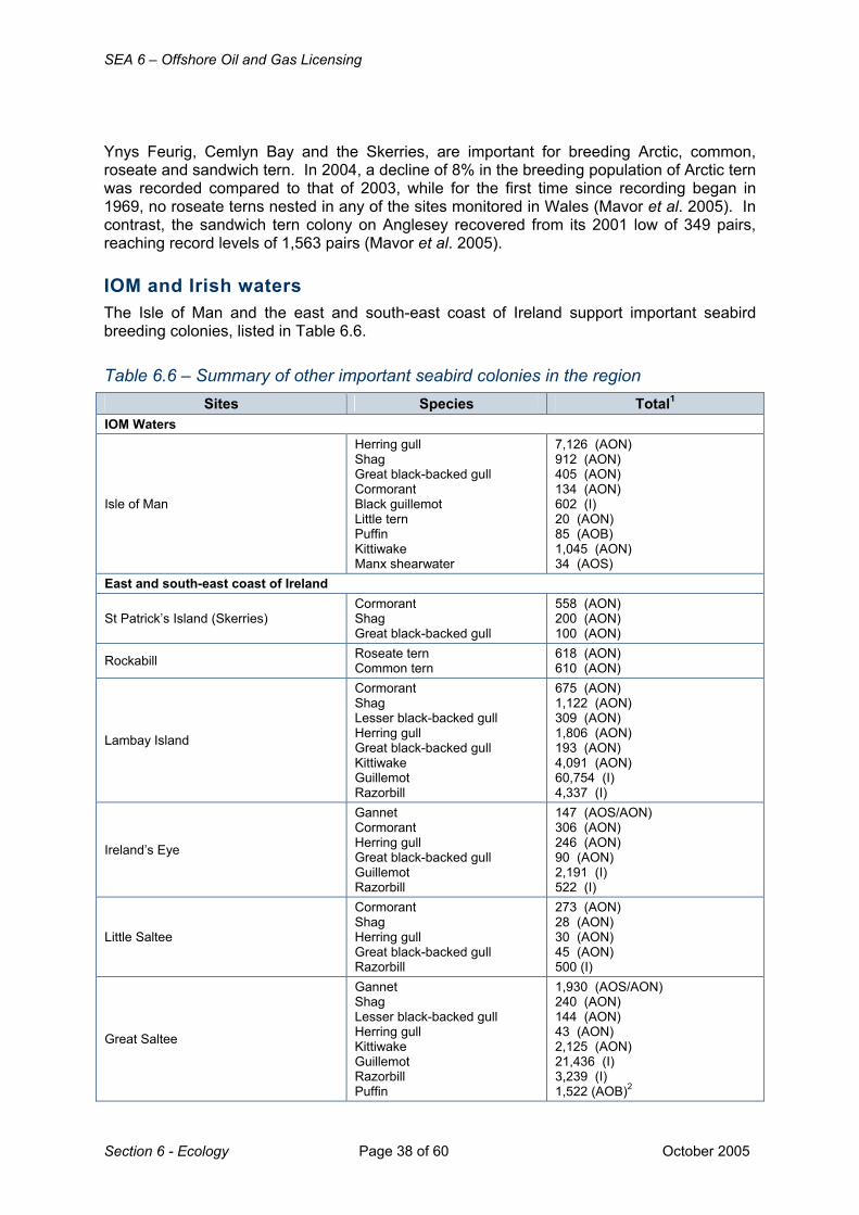
SEA 6 – Offshore Oil and Gas Licensing
Section 6 - Ecology Page 38 of 60 October 2005
Ynys Feurig, Cemlyn Bay and the Skerries, are important for breeding Arctic, common, roseate and sandwich tern. In 2004, a decline of 8% in the breeding population of Arctic tern was recorded compared to that of 2003, while for the first time since recording began in 1969, no roseate terns nested in any of the sites monitored in Wales (Mavor et al. 2005). In contrast, the sandwich tern colony on Anglesey recovered from its 2001 low of 349 pairs, reaching record levels of 1,563 pairs (Mavor et al. 2005). IOM and Irish waters The Isle of Man and the east and south-east coast of Ireland support important seabird breeding colonies, listed in Table 6.6.
Table 6.6 – Summary of other important seabird colonies in the region Sites Species Total1
IOM Waters
Isle of Man
Herring gull Shag Great black-backed gull Cormorant Black guillemot Little tern Puffin Kittiwake Manx shearwater
7,126 (AON) 912 (AON) 405 (AON) 134 (AON) 602 (I) 20 (AON) 85 (AOB) 1,045 (AON) 34 (AOS)
East and south-east coast of Ireland
St Patrick’s Island (Skerries) Cormorant Shag Great black-backed gull
558 (AON) 200 (AON) 100 (AON)
Rockabill Roseate tern Common tern
618 (AON) 610 (AON)
Lambay Island
Cormorant Shag Lesser black-backed gull Herring gull Great black-backed gull Kittiwake Guillemot Razorbill
675 (AON) 1,122 (AON) 309 (AON) 1,806 (AON) 193 (AON) 4,091 (AON) 60,754 (I) 4,337 (I)
Ireland’s Eye
Gannet Cormorant Herring gull Great black-backed gull Guillemot Razorbill
147 (AOS/AON) 306 (AON) 246 (AON) 90 (AON) 2,191 (I) 522 (I)
Little Saltee
Cormorant Shag Herring gull Great black-backed gull Razorbill
273 (AON) 28 (AON) 30 (AON) 45 (AON) 500 (I)
Great Saltee
Gannet Shag Lesser black-backed gull Herring gull Kittiwake Guillemot Razorbill Puffin
1,930 (AOS/AON) 240 (AON) 144 (AON) 43 (AON) 2,125 (AON) 21,436 (I) 3,239 (I) 1,522 (AOB)2

SEA 6 – Offshore Oil and Gas Licensing
October 2005 Page 39 of 60 Section 6 - Ecology
Sites Species Total1
Lady’s Island Lake Roseate tern Common tern
116 (AON) 480 (AON)
Wexford Harbour Little tern 40 (AON) Notes: AON: Apparently Occupied Nests, AOB: Apparently Occupied Burrows, AOS: Apparently Occupied Sites, I: Individuals
1. Population counts from Mitchell et al. 2004 – Seabird 2000 survey results 2. 1 bird approximates to 1 AOB
Source: Mitchell et al. 2004, Key areas for non-breeding seabirds Key areas for non-breeding seabirds in the SEA 6 area are listed Table 6.7.
Table 6.7 – Summary of key areas for non-breeding seabirds in the SEA 6 area Site Species1 Site Species
Scenario area 1 Tremadog Bay Cormorant Scenario area 3
Clyde Estuary Cormorant, black-headed gull, sandwich tern
Copeland Islands Manx shearwater2, razorbill2, Arctic tern
Belfast Lough
Herring gull, black-headed gull, sandwich tern, cormorant, common gull, black guillemot, great black-backed gull
Dundrum Bay Sandwich tern, black guillemot
Outer Ards Black-headed gull, shag, herring gull, cormorant, great black-backed gull
Carlingford Lough Cormorant
Strangford Lough Black-headed gull, cormorant, shag
St John’s Point Manx shearwater2, black guillemot2, kittiwake2, razorbill2
Scenario area 4
Solway Firth Cormorant Furness Coast Lesser black-backed gull, herring gull, cormorant
South Walney & Foulney Island Herring gull Duddon Estuary Sandwich tern, little tern,
lesser black-backed gull
Morecambe Bay
Great black-backed gull, herring gull, lesser-black-backed gull, cormorant, black-headed gull
Scenario area 5
Hilbre & Dee Estuary
Sandwich tern, little gull, little tern, common tern, cormorant, great black-backed gull
Alt Estuary Common tern, lesser black-backed gull, cormorant, little gull, herring gull
Shell Flat Little gull Marshside Herring gull Dee Estuary Sandwich tern2 Scenario area 7
Formby Point Lesser black-backed gull, common tern, cormorant
Seaforth NR Little gull, common tern, lesser black-backed gull, cormorant
Source: Barton & Pollock 2005a Notes 1. Species marked in bold occur in internationally important numbers
2. Passage counts

SEA 6 – Offshore Oil and Gas Licensing
Section 6 - Ecology Page 40 of 60 October 2005
Seabirds at sea Areas of the Irish Sea vary in importance over the year. Manx shearwater return to European waters in spring to breed. From May to August birds remain relatively close to their breeding colonies. In August and particularly in September, in flocks the Irish Sea Front area possibly hold the majority of the population from the adjacent breeding colonies before they leave for their wintering grounds. Fronts are regions of enhanced biological productivity. Different species were found to use frontal areas differently (Begg & Reid 1997). Little gulls (Larus minutus) winter in the Irish Sea and concentrations are found off Liverpool. During the breeding season, sandwich, common and Arctic terns are generally seen in waters near their colonies. Following the breeding season, a concentration of terns occurs between Holyhead and Ireland. Gannet, is present in the SEA 6 area throughout the year, but are generally only in the North Channel and St George’s Channel in autumn and winter (Mackey et al. 2005). Birds concentrate around colonies during the breeding season and following breeding, are more widely distributed throughout the Irish Sea, with concentrations found around the Irish Sea and Celtic Sea Fronts. Cormorant and shag are present year round in coastal areas with concentrations found off Liverpool (cormorant) and in the North Channel (shag). Herring gull are also present year round with concentrations found offshore and in coastal waters of the central Irish Sea. Kittiwakes are widely distributed over the whole of the SEA 6 area at relatively high densities throughout the year, with the exception of the waters to the south-west of the Lleyn Peninsula in the post breeding season and autumn (Mackey et al. 2005). Highest densities of guillemot are generally observed during the breeding and post-breeding seasons. Densities decrease during autumn and winter, however they remain present in the SEA 6 area at this time (Mackey et al. 2005). The distribution of razorbill, is generally less widespread than that of guillemots. Both species congregate in large concentrations post breeding, where adults moult and the young are still flightless. Concentrations of moulting auks are found throughout the Irish Sea from July through August, becoming more localised in the western and central Irish Sea during late August and September. By October and through November high densities are still present in the North Channel, with concentrations also found in the eastern Irish Sea and Cardigan Bay (Webb et al. 1995).
6.7.3 Waterbird species and geographical distributions Waterbirds include divers and grebes, bitterns and herons, rails, crakes and coots, wildfowl (JNCC refer to this group as waterfowl) and waders. Seaducks will also be discussed in this section. Key areas for breeding waterbirds In general, the numbers of breeding waders and other waterbirds on the west coast of Wales (Scenario areas 1 and 2), is relatively low compared to other parts of Britain. However, the Dyfi Estuary is one of the most important areas in Wales for breeding waders, particularly breeding redshank (Tringa totanus), teal (Anas crecca), red-breasted merganser (Mergus serrator) and shelduck (Tadorna tadorna). The area also includes the Milford Haven and the Cleddau Estuaries, both of which support summer breeding populations of shelduck.

SEA 6 – Offshore Oil and Gas Licensing
October 2005 Page 41 of 60 Section 6 - Ecology
The Ribble, Morecambe Bay and the Solway Firth have species-rich breeding wader assemblages (Craddock & Stroud 1996). Large numbers of ringed plover (Charadrius hiaticula) breed in Morecambe Bay, the Solway Firth and Luce Bay (all within Scenario area 4). These are the main breeding concentrations of this species on the west coast of Britain outside the Outer Hebrides (Cradock & Stroud 1996). The Inner Solway, the Ribble (Scenario area 5), Morecambe Bay and Duddon Estuary (Scenario area 4) have large breeding populations of shelduck, redshank, oystercatcher, dunlin (the most southerly regularly saltmarsh breeding dunlin in Britain) and curlew. The dry grassland breeding population of shelduck in the Ribble Estuary is the most numerous in Britain. Breeding eider (Somateria mollissima) are also found in Morecambe Bay (the most southerly breeding population in Britain) and around Walney Island (Gibbons et al. 1993). One of the main concentrations of shelduck in Scotland is found in Kintyre (Scenario area 3) (Gibbons et al. 1993), with other breeding sites including the shores of Bute, Inchmarnock and Little Cumbrae. The majority of the Scottish breeding population of red-breasted merganser are concentrated on the west coast of Scotland, some of which is included in the SEA 6 area, while eider breed on Lady Isle (off Troon) and on Horse Isle (off Ardrossan). Little Cumbrae supports large numbers of nesting ducks, predominantly eider, mallard (Anas platyrhynchos), shelduck, teal and red-breasted merganser. There are large colonies of eider duck on Sanda, Sheep and Glunimore Islands, off the Kintyre Peninsula. A small number of red-throated diver (Gavia stellata) nest on the south-west mainland of Scotland. Sites with breeding birds along the east coast of Ireland include Lady’s Island Lake and the islands within it, which support a number of breeding waterbirds including great crested grebe, mallard, tufted duck, coots and moorhens (Hutchinson 1994). Key areas for wintering and migrant waterbirds The SEA 6 area contains some of the most important sites for many wintering or migratory species of waterbird in the UK (Figure 6.20). The Dyfi, Dee, Mersey, Ribble and Alt Estuaries, Morecambe Bay, Duddon Estuary, Belfast Lough, Strangford Lough and the Solway Firth are individually and collectively of major international and national importance for their over winter populations of waterbirds. There is considerable interchange in the movements of wintering birds between sites The SEA 6 area lies on a major migratory flyway and in spring and autumn many birds pass through and utilise the region as a staging post during onward migration to wintering grounds (Rehfisch et al 2003). SEA 6 area Scenario area 1 Along with Liverpool Bay and Carmarthan Bay (just to the south of SEA 6), the area is of particular importance for common scoter, red-throated diver and great-crested grebe. The Dyfi estuary complex contains extensive sand dunes together with sand banks, mud flats, saltmarshes, peat bogs, river channels and creeks. The site supports nationally important numbers of wigeon (Anas penelope) (Pollitt et al. 2003) and is an important wintering area for Greenland white-fronted geese (Anser albifrons flavirostris). They generally arrive at their wintering grounds in October (Fox & Stroud 2002) and remain until mid-April (Wernham et al. 2002). Other important sites in Scenario area 1 include the Cleddau Estuary, with nationally important numbers of dunlin, curlew, shelduck, wigeon and teal (Pollitt et al. 2003) and
SEA 6 – Offshore Oil and Gas Licensing
Section 6 - Ecology Page 42 of 60 October 2005
Tremadog Bay with wintering common scoter and Slavonian grebe (Podiceps auritus) (Barton & Pollock 2005a).
Figure 6.20 - General distribution and movements of migratory waterbirds
Source: Cranswick 2003, Cranswick et al. 2004, Dean et al. 2003, Wernham et al. 2002

SEA 6 – Offshore Oil and Gas Licensing
October 2005 Page 43 of 60 Section 6 - Ecology
Scenario area 2 The important areas in Scenario area 2 such as the Holy Island Coast are primarily for breeding and wintering chough and see Other Bird Species section below.
Scenario area 3 Strangford Lough qualifies as a Wetland of International Importance as it regularly supports over 60,000 individual waterbirds in winter. The area holds internationally important numbers of shelduck, redshank and light-bellied Brent goose (Branta bernicla hrota), and the area is of All-Ireland importance in Northern Ireland for a further 20 species. The numbers of light-bellied Brent geese during winter exceeds the internationally important threshold at Killough Harbour; Dundrum Bay; Outer Ards; Larne Lough and Carlingford Lough. Carlingford Lough includes is an important feeding area for the wintering Brent geese and is of All-Ireland Importance for eleven species, shelduck, scaup (Aythya marila), oystercatcher, ringed plover, great-crested grebe, dunlin, goldeneye (Bucephala clangula), redshank, long-tailed duck, (Clangula hyemalis), red-breasted merganser and grey plover (Pluvialis squatarola) (Pollitt et al. 2003). Belfast Lough is a Wetland of International Importance and regularly supports over 20,000 individual waterbirds over winter. The area is of international importance for great crested grebe and redshank, and nationally important for mute swan (Cygnus olor), shelduck, scaup, eider, goldeneye, red-breasted merganser, oystercatcher, ringed plover, knot, dunlin, black-tailed godwit (Limosa limosa) and turnstone (Arenaria interpres) (Pollitt et al. 2003). Purple sandpiper (Calidris maritima), red-throated diver, black-throated diver (Gavia arctica), long-tailed duck and common scoter are of All-Ireland importance in Northern Ireland (Pollitt et al. 2003 and Barton & Pollock 2005a). Larne Lough is an area of All-Ireland Importance for at least six species of waterbird including Slavonian grebe, and has internationally important numbers of light-bellied Brent geese. Outer Ards Peninsula has at least eleven species of All-Ireland Importance for Northern Ireland (Pollitt et al. 2003). Other important sites for wintering waterbirds on the coast of Northern Ireland include the Copeland Islands, St John’s Point and Dundrum Bay (Pollitt et al. 2003, Barton & Pollock 2005a). The Clyde Estuary supports internationally important numbers of redshank and eider and nationally important numbers of oystercatcher and curlew. Other wintering species include Slavonian grebe, red-throated diver, goldeneye, red-breasted merganser, scaup, red-necked grebe (Podiceps grisegena) and whooper swan (Cygnus cygnus).
Scenario area 4 The Upper Solway Flats, Morecambe Bay and the Duddon Estuary are all Wetlands of International Importance.
The flats and marshes of the Upper Solway form one of the largest continuous areas of intertidal habitat in Britain and is of international importance for shelduck, pintail (Anas acuta), oystercatcher, knot, dunlin, bar-tailed godwit (Limosa lapponica), curlew, redshank, whooper swan, pink-footed goose (Anser brachyrhynchus) and Svalbard barnacle goose (Branta leucopsis) with at least another 6 species of national importance (Pollitt et al. 2003, Barton & Pollock 2005a, b). The Solway Firth and nearby Nith Estuary, along with

SEA 6 – Offshore Oil and Gas Licensing
Section 6 - Ecology Page 44 of 60 October 2005
Morecambe Bay are key sites along the SEA 6 east coast for great-crested grebe (Barton & Pollock 2005a). The Solway Firth also supports wintering scaup, common scoter and red-throated diver. Morecambe Bay is one of the largest estuarine systems in the UK and regularly holds over 210,000 waterbirds in winter. The bay is of particular importance for migrating waders. The site has internationally important numbers of eider, shelduck, pintail, oystercatcher, knot, dunlin, bar-tailed godwit, curlew, redshank, turnstone and pink-footed goose and nationally important numbers of eleven other species (Pollitt et al. 2003, Barton & Pollock 2005a, b). The Duddon Estuary is important for large numbers of wintering and passage waterbirds. The area regularly has over 70,000 waterbirds and acts as a cold weather refuge when numbers may increase. The area has important high tide roosts for wintering waterbirds and feeding areas for both wintering and migratory waterbirds, and is of international importance for redshank and nationally important for a further seven species. Torrs Warren has important numbers of Greenland white-fronted geese. South Walney and Foulney Island support red-throated diver and internationally important numbers of eider (Pollitt et al. 2003).
Scenario area 5 Liverpool Bay is a key area for common scoter with Shell Flats and Colwyn Bay being of particular importance. Aerial surveys of common scoter in Liverpool Bay between 2000 and 2004 indicated an apparent shift of birds to deeper waters as winter progresses presumed to be in response to food depletion (Cranswick et al. 2004). Over 6,000 birds were recorded during a survey in August 2002 (Cranswick et al. 2004), when the birds where in moult. Observations in the spring of 2002 indicated that main departure of common scoter from Liverpool Bay is in late April or early May (Cranswick et al. 2004). Cranswick et al. also recorded a number of divers (chiefly thought to be red-throated divers) widely distributed throughout the Bay and extending further offshore than scoters. As numbers of divers exceeded the 1% national threshold in three months for both 2001-02 and 2002/03, Liverpool Bay qualifies for potential designation as a Marine SPA. At least fourteen species occur in internationally important numbers at the Ribble & Alt Estuaries and at least a further four species in nationally important numbers. The Dee Estuary and Mersey Estuary are Wetlands of International Importance regularly supporting over 130,000 and 99,000 individual waterbirds respectively in winter. The Dee estuary is one of the most important sites in England for redshank and curlew, present in internationally important numbers, as are teal, pintail, oystercatcher, grey plover, knot, black-tailed godwit, bar-tailed godwit and turnstone (Pollitt et al. 2003). Shelduck, teal, pintail, dunlin, black-tailed godwit, turnstone and redshank are present in international important numbers in the Mersey Estuary and a further three species are of national importance (Pollitt et al. 2003). The Mersey Narrows, North Wirral Foreshore and Blackpool can hold species at internationally or nationally important levels.
Scenario areas 6 and 7 Lavan Sands, Conway Bay and Formby Point support common scoter and red-throated diver. Lavan Sands and Conway Bay also hold red-breasted merganser, Slavonian grebe, great-crested grebe and are of particular importance for wintering oystercatchers acting as refuge areas for birds displaced from the Dee estuary during severe winter weather.

SEA 6 – Offshore Oil and Gas Licensing
October 2005 Page 45 of 60 Section 6 - Ecology
IoM and Irish waters The Isle of Man supports a number of wintering waterbirds, particularly golden plover, sandpiper and curlew. Several areas along the east and south-east coast of Ireland support internationally and nationally important numbers of wintering and passage birds, with a number of sites designated as Wetlands of International Importance. Black-throated divers are regularly seen off the coast of Lady’s Island Lake in spring, along with red-throated and great northern diver. Wexford Reserve (on the northern side of Wexford Harbour) is very important for wintering Green-fronted goose, and also holds Bewick’s swan, Svalbard light-bellied brent goose, wigeon, lapwing, golden plover and black-tailed godwit. In winter common scoter, goldeneye, scaup and red-breasted merganser are found off the east and south-east coast of Ireland. Flocks of common scoter occur off Courtown, Curracloe and Rosslare (Co. Wexford), as well as Gile’s Quay at Dundalk Bay (Co. Louth) and North Bull, while several other species use the shallow sandy waters of Wexford Harbour (Nairn et al. 1995).
6.7.4 Other bird species Within the SEA 6 area there are several SPAs designated for their breeding (and wintering) chough (Pyrrhocorax pyrrhocorax) populations with important sites along the west coast of Wales including Aberdaron Coast, Bardsey Island, Myndd Cilan, Trwyn y Wylfa, the St Tudwal Islands, Ramsey, St David’s Peninsula Coast, Skokholm, Skomer and the Holy Island Coast. The SEA 6 coastline has nationally important coastal breeding populations of peregrine (Falco peregrinus) particularly Cumbria, Dumfries and Galloway. Short-eared owls (Asio flammeus) breed on Skomer & Skokholm. The Isle of Man is also important for breeding chough and peregrine.
6.7.5 SPAs and other important bird areas Special Protection Areas and their seaward extension In the UK, terrestrial and coastal SPAs have already been classified in compliance with the Birds Directive (Council Directive on the Conservation of Wild Birds 79/409/EEC) and there are a number of SPAs in the SEA 6 area (see Section 7.3). Work is currently underway to identify marine SPAs (mSPA) and includes three complimentary components:
A. Seaward extensions to existing breeding seabird colony SPAs B. Inshore areas used by non-breeding birds e.g. seaduck, grebes and divers C. Aggregations of wide-ranging seabirds
To address A, in 2001 the JNCC surveyed seabirds in the waters immediately adjacent (to approximately 5km) to six seabird colonies hosting nationally and internationally important numbers of seabird species in order to formulate possible generic proposals for identifying seaward extensions of existing breeding seabird SPAs (McSorley et al. 2003). Grassholm SPA and Skokholm and Skomer SPA were included in this research. The JNCC recommended that boundaries of existing common guillemot, razorbill and puffin colony SPAs be extended by 1km and that the boundaries of gannet colony SPAs be extend by 2km (McSorley et al. 2003). With respect to the other components of mSPA identification:

SEA 6 – Offshore Oil and Gas Licensing
Section 6 - Ecology Page 46 of 60 October 2005
• An initial review of various survey data has resulted in a list of inshore sites for seaduck, divers and grebes that might be considered for SPA status.
• The European Seabirds at Sea database will be analysed to identify possible hotpots for seabirds with a view to possible SPA classification
A second consultation document on progress in this strand of work was issued in December 2004, the purpose of which was to explore whether generic guidance can be applied to extend existing breeding colony SPAs for seabirds other than guillemot, razorbill, puffin and gannet and provide the rationale behind the recommended action (Turnbull 2004). In June 2005 the JNCC published details of the methodological basis for identifying inshore SPAs for seaducks, divers and grebes (McSorley et al. 2005). Further details of the identification of mSPAs can be found in Section 7.4 Important Bird Areas
Figure 6.21 - Coastal IBAs in the SEA 6 region Source: Heath & Evans (2000) The Important Bird Areas (IBA) Programme of Birdlife International is a non-statutory worldwide initiative aimed at identifying and protecting a network of critical sites for the conservation of the world’s birds. (Heath & Evans 2000). Thirty-seven IBAs are located on the SEA 6 area coastline (Figure 6.21) many of which are also protected by existing SPA and other designations.
6.7.6 Seabird and Waterbird population trends in the UK Seabirds UK breeding population trends in seabird species are reviewed by Mavor et al (2005) and Mitchell et al. (2004). Over the last 30 years the numbers of seabirds breeding in Britain and Ireland has risen steadily from around 5 million (1969-1970) to over 8 million (1998-2002). However, over the last few years, productivity has been declining, with several species failing to rear many chicks and some experiencing complete breeding failure. The 2004 breeding season was the least productive since records began, particularly for colonies on the Northern Isles and many on the east coast of Britain (Mavor et al. 2005). Preliminary data from 2005 also suggests widespread breeding failure, on both east and west coasts. Factors influencing adult survival include senescence, disease, reduced food availability,
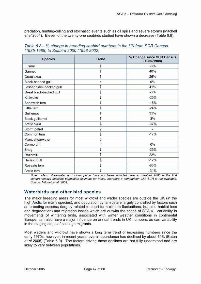
SEA 6 – Offshore Oil and Gas Licensing
October 2005 Page 47 of 60 Section 6 - Ecology
predation, hunting/culling and stochastic events such as oil spills and severe storms (Mitchell et al 2004). Eleven of the twenty-one seabirds studied have shown a decrease (Table 6.8).
Table 6.8 – % change in breeding seabird numbers in the UK from SCR Census (1985-1988) to Seabird 2000 (1998-2002)
Species Trend % Change since SCR Census (1985-1988)
Fulmar ↓ -3% Gannet ↑ 40% Great skua ↑ 26% Black-headed gull = 0% Lesser black-backed gull ↑ 41% Great black-backed gull ↓ -3% Kittiwake ↓ -25% Sandwich tern ↓ -15% Little tern ↓ -24% Guillemot ↑ 31% Black guillemot ↑ 3% Arctic skua ↓ -37% Storm petrel ? - Common tern ↓ -17% Manx shearwater ? - Cormorant = 0% Shag ↓ -25% Razorbill ↑ 22% Herring gull ↓ -12% Roseate tern ↓ -83% Arctic tern ↓ -31%
Note: Manx shearwater and storm petrel have not been included here as Seabird 2000 is the first comprehensive baseline population estimate for these, therefore a comparison with SCR is not available. Source: Mitchell et al. 2004.
Waterbirds and other bird species The major breeding areas for most wildfowl and wader species are outside the UK (in the high Arctic for many species), and population dynamics are largely controlled by factors such as breeding success (largely related to short-term climate fluctuations, but also habitat loss and degradation) and migration losses which are outwith the scope of SEA 6. Variability in movements of wintering birds, associated with winter weather conditions in continental Europe, can also have a major influence on annual trends in UK numbers, as can variability in the staging stops of passage migrants. Most waders and wildfowl have shown a long term trend of increasing numbers since the early 1970s, however, in recent years, overall abundance has declined by about 14% (Eaton et al 2005) (Table 6.9). The factors driving these declines are not fully understood and are likely to vary between populations.

SEA 6 – Offshore Oil and Gas Licensing
Section 6 - Ecology Page 48 of 60 October 2005
The UK supports more than 25% of the East Atlantic flyway populations of ten species of wading bird in winter and several of these have declined over both the long term and ten-year periods – see Table 6.9 (Eaton et al 2005).
Table 6.9 - Long term population trends of wintering waterbirds
Species *Long-term trend
**Ten-year trend
Species *Long-term trend
**Ten-year trend
European white-fronted goose ↓ ↓ Shoveler ↑ ↓ Bar-tailed godwit ↑ ↓ Curlew ↑ ↓ Mallard ↓ ↓ Pintail ↑ ↓ Knot ↑ ↓ Mute swan ↑ ↑ Pochard ↓ ↓ Greenland barnacle goose ↑ ↑ Dunlin ↓ ↓ Teal ↑ ↑ Shelduck ↑ ↓ whooper swan ↑ ↑ Ringed plover ↓ ↓ Pink-footed goose ↑ ↑ Turnstone ↓ ↓ Black-tailed godwit ↑ ↑ Sanderling ↑ ↑ Grey plover ↑ ↓ Icelandic greylag goose ↑ ↓ Svalbard barnacle goose ↑ ↑ Red-breasted merganser ↑ ↑ Canada goose ↑ ↑ Tufted duck ↑ ↑ Gadwall ↑ ↑ Goldeneye ↑ ↓ Dark-bellied Brent goose ↑ ↓ Oystercatcher ↑ ↓ Coot N/A ↑ Wigeon ↑ ↑ Great crested grebe N/A ↑
Goosander ↑ ↓ Greenland white fronted goose N/A ↑
Redshank ↓ ↓ Canadian light-bellied Brent goose N/A ↑
Svalbard light-bellied Brent goose ↑ ↑ Little grebe N/A ↑
Bewick’s swan ↓ ↓ Note: *Long term trends are % changes between the 3-year mean for the winters 1968-69, ’69-70 & ’70-71 and the winters 2000-01, ’01-02 & ’02-03 for wildfowl and between the 3-year mean for the winters 1974-04, ’75-76 & ’76-77 and the winters 2000-01, ‘02-02 & ’02-03 for wading birds. **Ten-year trends are % changes between the 3-year mean for the winters 1990-91, ’91-92 & ’92-93 and the winters 2000-01, ’01-02 & ’02-03. National monitoring of coot, great crested grebe, little grebe, Canadian light-bellied Brent goose and Greenland white-fronted goose started later than for other species and only 10-year trends are shown. Source: Eaton et al 2005.
The long-term decline in UK numbers of European white-fronted goose is not reflected in the overall trend of this population at a flyway scale (Eaton et al. 2005). Conversely, in recent years, the Greenland white-fronted goose population has declined, which is not reflected in the ten-year trend in the UK. With the exception of both the Icelandic greylag goose (Anser anser) and the dark-bellied Brent goose which remain in short-term decline, most other geese populations are faring well. Both shelduck and goosander have shown downward trends over the last ten years, although, both appear to be stabilising after periods of rapid declines and increase. However, the rapid decline in recent years in the number of Bewick’s swan (Cygnus columbianus bewickii) is of increasing concern (Eaton et al. 2005).

SEA 6 – Offshore Oil and Gas Licensing
October 2005 Page 49 of 60 Section 6 - Ecology
6.7.7 Seabird vulnerability to surface pollution
Figure 6.22 - Overall vulnerability of seabirds to surface pollution Source: JNCC (1999) The vulnerability of seabird species to oil pollution at sea is dependant on a number of factors and varies considerably throughout the year. The Offshore Vulnerability Index (OVI) developed by JNCC and used to assess the vulnerability of bird species to surface pollution considers four factors: • the amount of time spent
on the water • total biogeographical
population • reliance on the marine
environment • potential rate of population
recovery (Williams et al. 1994)
Of the species commonly present in the SEA 6 area, Manx shearwater, gannet, auk species and seaducks, in
particular common scoter and divers are the most vulnerable to oil pollution due to a combination of heavy reliance on the marine environment, low breeding output with a long period of immaturity before breeding, the regional presence of a large percentage of the biogeographic population and that some species congregate in large concentrations on the sea surface and are flightless due to annual moults. In contrast, the aerial habits of the fulmar and gulls, together with large populations and widespread distribution, reduce vulnerability of these species. Overall vulnerability to surface pollutants (taking seasonal variability into account); seasonality (expressed as number of months in which very high vulnerability occurs) and data gaps (defined as blocks for which two or more consecutive months are unsurveyed) are shown in Figures 6.22 and 6.23. Overall vulnerability of seabirds to surface pollution is very high in some blocks of Quadrants 111 and 108 (Scenario area 3), 110 (Scenario area 5), 105, 103 and 107 (Scenario area 1) and high in some blocks of Quadrants 111, 108 (Scenario area 3), 109 (Scenario areas 2, 3

SEA 6 – Offshore Oil and Gas Licensing
Section 6 - Ecology Page 50 of 60 October 2005
and 6), 110 (Scenario areas 5 and 7), 105 (Scenario areas 1 and 2) and 107 (Scenario areas 1 and 2). All of the other blocks within the SEA 6 area are either moderate or low.
Figure 6.23 - Seasonal vulnerability of seabirds to surface pollution Note: Seasonal vulnerability expressed as number of months in which very high vulnerability is present. Source: JNCC (1999). Much of the seabird vulnerability is associated with proximity of breeding colonies and post-breeding dispersal of auks and is seasonal. Vulnerability is very high for between 6 and 8 months of the year in some blocks of Quadrants 111 and 108 (Scenario area 3) and Quadrant 103 (southern part of Scenario area 1). The rest of the blocks have very high vulnerability for less than 6 months per year, with the exception of some blocks in Quadrants 113 (Scenario area 4), 109 (Scenario areas 2 and 6), 110 (Scenario areas 5, 6 and 7) and 106 and 107 (Scenario area 1) with no months of very high vulnerability (Figure 6.23). There are no areas with two or more consecutive months without survey data in the SEA 6
area.
6.7.8 Relevant data gaps Understanding of seabird and waterbird distribution in the SEA 6 area is generally adequate to support the SEA 6 process. Several gaps were identified by the SEA 6 assessment workshop and stakeholder meeting. OVI analyses needs to be updated to include new (since ≈1999) data, e.g. recent aerial survey data. As a consequence, some areas with high vulnerability for common scoter are not reflected in OVI maps – both Shell Flat and Colwyn Bay are very important. A review of spatial and seasonal gaps in ESAS coverage is currently being undertaken funded through the SEA process. New information on nearshore bird distribution will be generated by further aerial survey effort planned to support identification of potential offshore SPAs (JNCC) and in Round 2 offshore windfarm areas.

SEA 6 – Offshore Oil and Gas Licensing
October 2005 Page 51 of 60 Section 6 - Ecology
6.8 Marine mammals
6.8.1 Data sources The Sea Mammal Research Unit (SMRU), St Andrews, was commissioned to produce a review describing the distribution and abundance of marine mammals in the SEA 6 area. No quantitative information on absolute cetacean abundance is available for the region, with information coming from various surveys including a 2001 survey of the Cardigan Bay Special Area of Conservation and the SCANS (Small Cetacean Abundance in the North Sea) (1994 and 2005). Other effort related sightings surveys (Figure 6.24) have been conducted by Sea Watch Foundation, the JNCC Seabirds at Sea Team, Earthkind, Whale and Dolphin Conservation Society and Friends of Cardigan Bay. A three year study of short-beaked common dolphins (Delphinus delphis) and other cetaceans off Pembrokeshire was reported by Earl et al. (2004). A series of INTERREG projects (Kiely et al. 2000, Rogan et al. 2001) provide useful information on marine mammal distributions in the Irish and Celtic Seas. Also of relevance is information from the UK national cetacean sightings database of observations in Wales since 1990 and a more localised database for south west Wales produced in the wake of the Sea Empress oil spill (Baines et al. 1997).
Figure 6.24 - Distribution of sighting effort in the SEA 6 area Source: Hammond et al. (2005). During the SCANS-II survey in summer 2005, over 30,000km of transects were surveyed by ship and more than 200 hours surveyed by aircraft. The survey area included all shelf waters from 36º-62ºN. The focal species was the harbour porpoise, as new estimates of abundance were needed to assess and manage bycatch of this species in certain fisheries (see Section 6.8.2 for details of SCANS II harbour porpoise sightings, SCANS II website - http://biology.st-andrews.ac.uk/scans2/). Data analysis is currently underway with results expected mid-2006. The Coastal and Marine Resources Centre, University College Cork produced a review for SEA 6 (Mackey et al. 2005) summarising the availability, type and quality of available data on the seasonal distribution of offshore
cetacean populations in the SEA 6, 7 and 8 areas. The Atlas of cetacean distribution in north-west European waters (Reid et al. 2003) provides an account of the 28 cetacean species which have occurred in the waters off north-west Europe in the last 25 years. Information on the distribution and abundance of grey seals around Britain is available from various SMRU and other studies (SCOS 2004, Matthiopoulos et al. 2004 etc). In the SEA 6 area, most work on grey seals has been conducted by CCW (Baines et al. 1995; Wescott &

SEA 6 – Offshore Oil and Gas Licensing
Section 6 - Ecology Page 52 of 60 October 2005
Stringell 2004) but new data are now available from DTI funded SMRU study work (Hammond et al. 2005). There is less information available on harbour seal; the most detailed data are from SMRU aerial thermal imaging surveys conducted during the moult (SCOS 2004, Cronin et al. 2004).
6.8.2 Distribution and abundance The SEA 6 area, particularly scenario areas 1, 2 and 3, is an important area for marine mammals (Figure 6.25, Hammond et al. 2005).
Figure 6.25 – Important areas for marine mammals
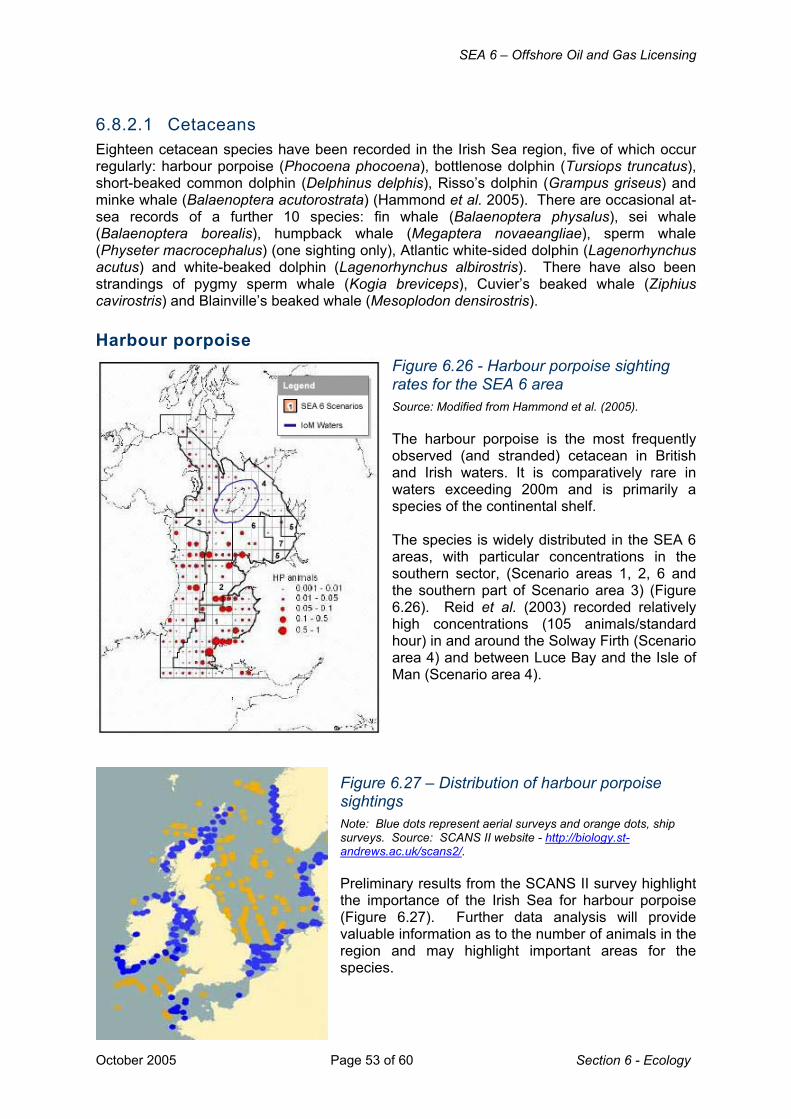
SEA 6 – Offshore Oil and Gas Licensing
October 2005 Page 53 of 60 Section 6 - Ecology
6.8.2.1 Cetaceans Eighteen cetacean species have been recorded in the Irish Sea region, five of which occur regularly: harbour porpoise (Phocoena phocoena), bottlenose dolphin (Tursiops truncatus), short-beaked common dolphin (Delphinus delphis), Risso’s dolphin (Grampus griseus) and minke whale (Balaenoptera acutorostrata) (Hammond et al. 2005). There are occasional at-sea records of a further 10 species: fin whale (Balaenoptera physalus), sei whale (Balaenoptera borealis), humpback whale (Megaptera novaeangliae), sperm whale (Physeter macrocephalus) (one sighting only), Atlantic white-sided dolphin (Lagenorhynchus acutus) and white-beaked dolphin (Lagenorhynchus albirostris). There have also been strandings of pygmy sperm whale (Kogia breviceps), Cuvier’s beaked whale (Ziphius cavirostris) and Blainville’s beaked whale (Mesoplodon densirostris). Harbour porpoise
Figure 6.26 - Harbour porpoise sighting rates for the SEA 6 area Source: Modified from Hammond et al. (2005). The harbour porpoise is the most frequently observed (and stranded) cetacean in British and Irish waters. It is comparatively rare in waters exceeding 200m and is primarily a species of the continental shelf. The species is widely distributed in the SEA 6 areas, with particular concentrations in the southern sector, (Scenario areas 1, 2, 6 and the southern part of Scenario area 3) (Figure 6.26). Reid et al. (2003) recorded relatively high concentrations (105 animals/standard hour) in and around the Solway Firth (Scenario area 4) and between Luce Bay and the Isle of Man (Scenario area 4).
Figure 6.27 – Distribution of harbour porpoise sightings Note: Blue dots represent aerial surveys and orange dots, ship surveys. Source: SCANS II website - http://biology.st-andrews.ac.uk/scans2/. Preliminary results from the SCANS II survey highlight the importance of the Irish Sea for harbour porpoise (Figure 6.27). Further data analysis will provide valuable information as to the number of animals in the region and may highlight important areas for the species.

SEA 6 – Offshore Oil and Gas Licensing
Section 6 - Ecology Page 54 of 60 October 2005
Bottlenose dolphin
Figure 6.28 - Bottlenose sighting rates for the SEA 6 area Source: Modified from Hammond et al. 2005 The bottlenose dolphin is locally fairly common off the coasts of Spain, Portugal, north-west France, southern and western Ireland, north-east and south-west Scotland, in the Irish Sea and the English Channel (Reid et al. 2003, Evans et al. 2003). This social dolphin commonly forms groups of 2-25 animals (Reid et al. 2003) and in coastal waters often favours river estuaries, headlands or sandbanks where there is an uneven bottom relief and/or strong tidal currents (Lewis & Evans 1993, Liret et al. 1994, Wilson et al. 1997, Rogan et al. 2000, Ingram & Rogan 2002). In the Irish Sea, there are concentrations of bottlenose dolphins in Cardigan Bay, particularly the southern portion and off the coast of Co. Wexford (south-east Ireland) (Figure 6.28).
Although effort-related observations are few in the northern Irish Sea, this species is regularly sighted in summer off the Galloway coast of south-west Scotland, around the Isle of Man and north Anglesey (Hammond et al. 2005). The bottlenose population of the Cardigan Bay SAC and coastal waters down to Fishguard has been estimated at 213 individuals, which are mainly concentrated in coastal waters (Baines et al. 2002), although the overall population may be larger since animals are sighted some distance north of the SAC (Hammond et al. 2005). In Wales, sightings rates increase through the summer, peaking in July-August, with a low between October and April. A long-term land-based study (1989-96) at New Quay in Cardigan Bay, found that 92% of all sightings occurred between April and November, with 48% between June and August; sightings rates were lowest in March and highest in July (Bristow & Rees 2001). Short-beaked common dolphin The short-beaked common dolphin is abundant and widely distributed in the eastern North Atlantic, mainly occurring in deeper waters from the Iberian Peninsula north to the Faroe Islands. Relative to other areas round the UK, the most important areas for this species include the southern Irish Sea, the Celtic Sea, South West Approaches and the south-west coast of Ireland (Reid et al. 2003). This species is regularly seen in the far south of the SEA 6 area (Figure 6.29), particularly in summer and autumn. In near-shore waters of Ireland, the greatest number of sightings reported to the Irish Whale and Dolphin Group has been from Galway Bay, around the Aran Islands and along the south Cork coast (Berrow et al. 2001).

SEA 6 – Offshore Oil and Gas Licensing
October 2005 Page 55 of 60 Section 6 - Ecology
The population estimate from the 1994 SCANS survey covering the Celtic Sea to approximately 11°W and 48°S was 75,449 (95% CI:22,900-249,900). The population status of this species within the southern Irish Sea is currently unknown and the 1994 SCANS survey did not include the waters around the Pembrokeshire coast
Figure 6.29 - Short-beaked common dolphin sighting rates for the SEA 6 area Source: Modified from Hammond et al. 2005 A study was initiated in 2001 to examine the distribution and abundance of this species in the sea area between St David’s Head and Linney Head, including the Pembrokeshire islands of Skomer, Skokholm and Ramsey, west to the Smalls reef and across a part of St George’s Channel, and 22 boat-based surveys were carried out between November 2001 and September 2003 (excluding winter months December – February) (Earl et al. 2004). In late summer and early autumn, short-beaked common dolphin are thought to migrate north from the Bay of Biscay and the southern Celtic Sea, which may be correlated with shifting prey distribution (Earl et al. 2004).
Risso’s dolphin
Figure 6.30 - Risso’s dolphin sighting rates for the SEA 6 area Source: Modified from Hammond et al. 2005 Risso’s dolphin is generally a gregarious species forming small to medium-sized groups (6-12 individuals), but sometimes recorded singly (Reid et al. 2003). A major concentration of Risso’s dolphin in northern European waters occurs in the Hebrides but the species is regularly seen in other areas including the Irish Sea, while it is rare in all but the western end of the English Channel (Hammond et al. 2005). In the Irish Sea this species is seen particularly off north Wales (around Bardsey Island) and in the St George’s Channel (mainly off the Wexford coast of Ireland near the Saltee islands and west of Pembrokeshire islands (Figure 6.30) with incidental sightings also recorded around the Isle of Man (Hammond et al. 2005).

SEA 6 – Offshore Oil and Gas Licensing
Section 6 - Ecology Page 56 of 60 October 2005
Minke whale Minke whales are widely distributed in all the major oceans of the world. They are usually seen singly or in pairs, although when feeding they sometimes aggregate into larger groups (10-15 individuals, Reid et al. 2003). They take a wide variety of fish and shellfish such as herring, cod, capelin, haddock, saithe and sandeels as well as euphausiids and pteropods.
Figure 6.31 - Minke whale sighting rates for the SEA 6 area Source: Modified from Hammond et al. 2005 In the SEA 6 area, minke whales occur mainly on the western side, south of the Isle of Man (Figure 6.31). They are not common in the Irish Sea, occurring mainly in summer and are rarely recorded north of the Isle of Man. A recent news report recorded sightings of 10 minke whales in the Irish Sea during one week in August 2005. The increased numbers are thought to be as a result of prey availability in the area - BBC news website http://www.bbc.co.uk/1/hi/wales/4162578.stm. The International Whaling Commission considers SEA 6 area minke whales to be part of a single north-eastern Atlantic stock. The SEA 6 area does not represent an important area for this species.
Other species Fin whale, long-finned pilot whale and killer whale have been regularly recorded in the area. Fin whale Most sightings of fin whales are of single animals or pairs (Reid et al. 2005) and in the eastern North Atlantic, this species is uncommon, occurring mainly in deep waters (200-4,000m depth, particularly around 1,000m isobath). In the SEA 6 and adjacent areas fin whales are occasionally sighted off southern Ireland and into the St George’s Channel (Scenario area 1) (Hammond et al. 2005). Fin whales have also been recorded close inshore from Strumble Head (PORPP/Sea Trust records, as cited in Earl et al. 2004). In August 2005 a school of fin whales were noted in the Irish Sea - BBC news website http://www.bbc.co.uk/1/hi/wales/4162578.stm. Long-finned pilot whale In British and Irish waters, long-finned pilot whales occur mainly along the continental slope, particularly around the 1,000m isobath. They are rare in the Irish Sea, mainly recorded in the eastern sector, sometimes very close to the coast (Hammond et al. 2005). Pilot whales have also been recorded around the Smalls in the southern Irish Sea (PORPP/Sea Trust records, as cited in Earl et al. 2004).

SEA 6 – Offshore Oil and Gas Licensing
October 2005 Page 57 of 60 Section 6 - Ecology
Killer whale Most sightings of killer whales in UK waters are of single animals or small, although groups of up to one hundred have been observed (Evans 1988, Pollock et al. 2000). In the SEA 6 area killer whales are occasionally seen around the Isle of Man and St George’s Channel (Hammond et al. 2005) and have been recorded around the Smalls and closer inshore from Strumble Head and Fishguard Bay (PORPP/Sea Trust records, as cited in Earl et al. 2004). 6.8.2.2 Pinnipeds Grey seal
Figure 6.32 – Distribution of grey seal haul-out sites around the Irish Sea Note: pink lines delimit areas for which surveys have not been done but opportunistic sightings recorded. Source: Hammond et al. 2005 Grey seals are restricted to the North Atlantic and adjacent seas. They haul out on land between foraging trips and for pupping and moulting. Timing of pupping differs throughout the range of the species. In northern Britain pupping occurs from October to late November. In Wales pups have been born in all months of the year with a peak in September. In the SEA 6 area, moulting occurs February-April (Hammond et al. 2005). The British grey seal population is estimated at 113,000 individuals and has been increasing by around 6% annually since the 1960s (SCOS 2004). The breeding population in Wales and Ireland is estimated at 5-7,000 animals (Keily et al. 2000) and the distribution of their haul-out
sites are shown in Figure 6.32. Most grey seals spend the majority of their time on land for several weeks in autumn (pupping and mating) and in spring (moult), therefore densities at sea are lower during these periods (Hammond et al. 2005). Hammond et al. (in press) employed satellite relay data loggers fitted to grey seals to examine the distribution of this species at sea. Figure 6.33a shows the tracks of 19 animals recorded from July to December 2004, while Figure 6.33b shows the predicted distribution of grey seals in the Irish Sea based on these data and counts of haul-out sites during the summer. All tracked seals remained in the Irish Sea and the north-western part of the Bristol Channel. There was very limited activity in the north-west Irish Sea. No animals travelled north of the Mull of Galloway through the North Channel (Hammond et al. 2005). There was much individual variability in the movement patterns with some animals ranging widely and spending time in a variety of locations, while others remained in one limited area for most of the time.

SEA 6 – Offshore Oil and Gas Licensing
Section 6 - Ecology Page 58 of 60 October 2005
Figure 6.33 – Grey seals in the SEA 6 area a) Tracks of tagged grey seals b) Estimated at sea usage by grey seals
Note: a) Each colour denotes the tracks of individual seals b) brightly coloured areas represent areas of greatest predicted use. Source: Modified from Hammond et al. 2005
The modelled at-sea usage for grey seals shows several areas of relatively high usage (Figure 6.33b). Predicted at-sea usage is based on return trips to the same haul-out sites so these high use areas are not simply the result of travelling between haul-out sites and can be assumed to be foraging. Much of the southern SEA 6 area out to around 40-50km offshore is important as foraging habitat for grey seals hauling out in Wales and Ireland (Hammond et al. 2005). Grey seals from other satellite relayed data logger deployments off western Scotland and off northern France have not entered the Irish Sea (Matthiopoulos et al. 2004). These data suggest that the grey seals that haul out in Liverpool Bay, Wales and the south-east Ireland may form a separate population from the seals to the north off western Scotland to the south off Cornwall and France (Hammond et al. 2005). Harbour seal Harbour seal pupping occurs from June to July pupping at which time females and pups spend a high proportion of their time ashore. The moult is centred around August extending into September when seals also spend a high proportion of their time ashore. (Hammond et al. 2005). Based on population counts during the moult (SCOS 2004), the number of harbour seals around Britain is estimated to be at least 50,000. There are few harbour seals around the Irish Sea, except along the coast of Northern Ireland and in the Firth of Clyde
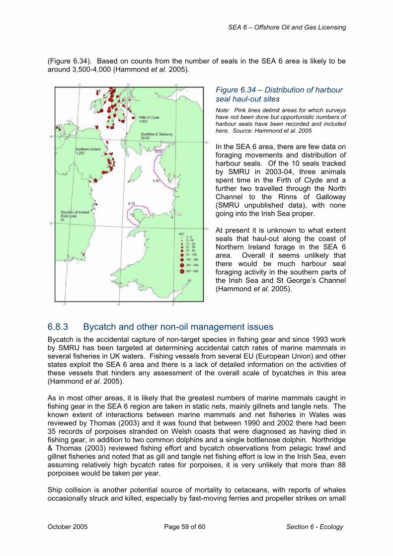
SEA 6 – Offshore Oil and Gas Licensing
October 2005 Page 59 of 60 Section 6 - Ecology
(Figure 6.34). Based on counts from the number of seals in the SEA 6 area is likely to be around 3,500-4,000 (Hammond et al. 2005).
Figure 6.34 – Distribution of harbour seal haul-out sites Note: Pink lines delimit areas for which surveys have not been done but opportunistic numbers of harbour seals have been recorded and included here. Source: Hammond et al. 2005 In the SEA 6 area, there are few data on foraging movements and distribution of harbour seals. Of the 10 seals tracked by SMRU in 2003-04, three animals spent time in the Firth of Clyde and a further two travelled through the North Channel to the Rinns of Galloway (SMRU unpublished data), with none going into the Irish Sea proper. At present it is unknown to what extent seals that haul-out along the coast of Northern Ireland forage in the SEA 6 area. Overall it seems unlikely that there would be much harbour seal foraging activity in the southern parts of the Irish Sea and St George’s Channel (Hammond et al. 2005).
6.8.3 Bycatch and other non-oil management issues Bycatch is the accidental capture of non-target species in fishing gear and since 1993 work by SMRU has been targeted at determining accidental catch rates of marine mammals in several fisheries in UK waters. Fishing vessels from several EU (European Union) and other states exploit the SEA 6 area and there is a lack of detailed information on the activities of these vessels that hinders any assessment of the overall scale of bycatches in this area (Hammond et al. 2005). As in most other areas, it is likely that the greatest numbers of marine mammals caught in fishing gear in the SEA 6 region are taken in static nets, mainly gillnets and tangle nets. The known extent of interactions between marine mammals and net fisheries in Wales was reviewed by Thomas (2003) and it was found that between 1990 and 2002 there had been 35 records of porpoises stranded on Welsh coasts that were diagnosed as having died in fishing gear, in addition to two common dolphins and a single bottlenose dolphin. Northridge & Thomas (2003) reviewed fishing effort and bycatch observations from pelagic trawl and gillnet fisheries and noted that as gill and tangle net fishing effort is low in the Irish Sea, even assuming relatively high bycatch rates for porpoises, it is very unlikely that more than 88 porpoises would be taken per year. Ship collision is another potential source of mortality to cetaceans, with reports of whales occasionally struck and killed, especially by fast-moving ferries and propeller strikes on small

SEA 6 – Offshore Oil and Gas Licensing
Section 6 - Ecology Page 60 of 60 October 2005
cetaceans and seals from small vessels. There are very few data with which to estimate the frequency of such events (Hammond et al. 2005).
6.8.4 Conservation framework Cetaceans and seals are listed on a raft of European Directives and UK Acts which offer protection from amongst other things, capture, disturbance or killing. Of particular relevance is that bottlenose dolphin, harbour porpoise, grey and harbour seals are listed on Annex II of the EC Habitats Directive requiring the designation of Special Areas of Conservation. Within the SEA 6 area there are designated SACs for bottlenose dolphin either as a primary reason for site selection (Cardigan Bay) or as a qualifying feature, but not the primary reason for selection (Lleyn Peninsula and the Sarnau). To date, no candidate SACs have yet been established for harbour porpoise. There are also SAC sites within SEA 6 for both grey and harbour seal (Table 6.10).
Table 6.10 – SACs for grey and harbour seals in the SEA 6 area
Species Presence of species as primary reason for site section
Species present as a feature but not primary reason for site selection
Grey seal Pembrokeshire Marine Cardigan Bay Lleyn Peninsula and the Sarnau
Harbour seal None Murlough Strangford Lough
Source: JNCC website http://www.jncc.gov.uk JNCC and the country conservation agencies are currently in the process of identifying offshore SAC sites (both within and outside territorial waters) for Annex II species. Details of this work and progress to date are presented in Section 7.3.
6.8.5 Relevant data gaps Work funded by the SEA programme has addressed the at-sea distribution of grey seals. A number of marine mammal ecology data gaps remain identified by Hammond et al. (2005) and the SEA 6 assessment workshop and stakeholder meeting: • The regularity and extent of cetacean migrations; specifically those of short-beaked
common dolphin • Effects of climate change on cetacean distribution – e.g. whether increased numbers of
sightings of fin and minke whales in recent years are likely to be a significant trend • Foraging distribution of harbour seals from haul-out sites in Northern Ireland • Whether specific areas are utilised by cetaceans – specifically harbour porpoise – for
calving (and if so, whether animals are particularly sensitive to disturbance) • Impact of by-catch and ship collision mortality on marine mammal population dynamics • The diet and feeding ecology of marine mammals in the SEA 6 area. For example,
because of the link between the abundance and availability of fish prey and the reproductive success of marine mammals, changes in the availability of principal forage fish may be expected to result in population level changes of marine mammals (Hammond et al. 2005).
However, although these are all important areas of understanding in the context of conservation of marine mammal species, they are not considered to represent significant constraints on the SEA 6 process.