3D Laser Scanning for Road Safety and Accident Reconstruction · 3D Laser Scanning for Road Safety...
15
TS 38 – Engineering Surveys for Construction Works I Vassilios Pagounis, Maria Tsakiri, Spiridon Palaskas, Barbara Biza, Elizabeth Zaloumi 3D Laser Scanning for Road Safety and Traffic Accident Reconstruction Shaping the Change XXIII FIG Congress Munich, Germany, October 8-13, 2006 1/15 3D Laser Scanning for Road Safety and Accident Reconstruction Vassilios PAGOUNIS, Maria TSAKIRI, Spriridon PALASKAS, Barbara BIZA and Elizabeth ZALOUMI, Greece Key words: terrestrial laser scanning, 3D model, traffic accident reconstruction, road safety SUMMARY The aim of traffic reconstruction is to recreate motor vehicle collision scenes in order to analyze the dynamics of the collision events, to provide evidence in court cases and allow the manufacturers to evaluate the vehicle’s design. However, at the scene of the accident it is not known exactly the amount of information that will be required at the analysis and often relevant data are missing. The emergence of terrestrial laser scanning has enabled the 3D documentation of accident events in a safer way, as information can be collected without any lane closures or traffic interruptions, and in a more flexible and faster way, as a single user can operate the instrument in complete darkness or direct sunlight. The notion of this paper is to describe the use of terrestrial laser scanning for roadway and roadside data collection in intersection areas and extract geometric features for road safety analysis. Also emphasis is given on the qualitative assessment of condition classification road data obtained by terrestrial laser scanning and results are presented from a variety of data collected by a Leica HDS2500 laser scanner from simulated traffic accident scenarios.
Transcript of 3D Laser Scanning for Road Safety and Accident Reconstruction · 3D Laser Scanning for Road Safety...
TS 38 – Engineering Surveys for Construction Works I Vassilios Pagounis, Maria Tsakiri, Spiridon Palaskas, Barbara Biza, Elizabeth Zaloumi 3D Laser Scanning for Road Safety and Traffic Accident Reconstruction Shaping the Change XXIII FIG Congress Munich, Germany, October 8-13, 2006
1/15
3D Laser Scanning for Road Safety and Accident Reconstruction
Vassilios PAGOUNIS, Maria TSAKIRI, Spriridon PALASKAS, Barbara BIZA and Elizabeth ZALOUMI, Greece
Key words: terrestrial laser scanning, 3D model, traffic accident reconstruction, road safety SUMMARY The aim of traffic reconstruction is to recreate motor vehicle collision scenes in order to analyze the dynamics of the collision events, to provide evidence in court cases and allow the manufacturers to evaluate the vehicle’s design. However, at the scene of the accident it is not known exactly the amount of information that will be required at the analysis and often relevant data are missing. The emergence of terrestrial laser scanning has enabled the 3D documentation of accident events in a safer way, as information can be collected without any lane closures or traffic interruptions, and in a more flexible and faster way, as a single user can operate the instrument in complete darkness or direct sunlight. The notion of this paper is to describe the use of terrestrial laser scanning for roadway and roadside data collection in intersection areas and extract geometric features for road safety analysis. Also emphasis is given on the qualitative assessment of condition classification road data obtained by terrestrial laser scanning and results are presented from a variety of data collected by a Leica HDS2500 laser scanner from simulated traffic accident scenarios.
TS 38 – Engineering Surveys for Construction Works I Vassilios Pagounis, Maria Tsakiri, Spiridon Palaskas, Barbara Biza, Elizabeth Zaloumi 3D Laser Scanning for Road Safety and Traffic Accident Reconstruction Shaping the Change XXIII FIG Congress Munich, Germany, October 8-13, 2006
2/15
3D Laser Scanning for Road Safety and Accident Reconstruction
Vassilios PAGOUNIS, Maria TSAKIRI, Spriridon PALASKAS, Barbara BIZA and Elizabeth ZALOUMI, Greece
1. INTRODUCTION Traffic accidents can occur whenever significant deficiencies, oversights, errors, omissions, or unanticipated changes are present. Any one of these conditions can be a precursor for an accident; the only uncertainties are when the accident will occur and how severe its consequences will be. To conduct a complete accident/incident investigation, the factors contributing to an accident, as well as the means to prevent accidents, must be clearly understood. Understanding how to prevent or control traffic accidents requires knowledge of the sequence of events leading to an accident, in order to identify and implement countermeasures. Therefore, the process of accident reconstruction can be considered as a sequence of operations involving the collection of data about the road transportation components (road, vehicles and people) and continues through inferences and conclusions about the sequence of events that constitute the accident and the relationship of these components during the events. Typically, there are five levels of activity in accident investigation as described in ANSI D (1983); (a) reporting, where basic data collection is used to identify and classify an accident, (b) at-scene investigation, whereby extra data are collected at the accident scene along with the results of the accident, such as marks on the road and debris, tire marks etc, (c) technical follow-up, which studies all available data relating to an accident, such as speed and acceleration of vehicles, visibility of vehicles, pedestrians etc, and is undertaken for legal and other specific purposes, (d) professional reconstruction which determines from the available data how the road, driver and vehicle contributed to a particular accident, and (e) cause analysis, which determines from the available data why the accident happened (eg deficiencies of road or vehicle design). Clearly, the data collection and recording at the accident scene is the most critical aspect as they are needed in all the aforementioned five levels of investigation. Furthermore, traffic recording systems should be technologically sophisticated to provide more timely, fast, accurate, integrated, accessible and more standardized and uniform data. Also, the measurement process should be as least disruptive to traffic as possible and provide end products that are easily transformed to 2D drawings. The most commonly measuring approach is 2D surveying where measurements of distances along and offset from a road edge or centerline are performed. Frequently, total stations and laser range finders are employed but with the disadvantage of being disruptive to traffic. GPS surveying is successfully used but only in unobstructed areas. Recently, close-range digital photogrammetric systems have been developed (e.g. Duignan et al., 1996; Fraser et al., 2004)
TS 38 – Engineering Surveys for Construction Works I Vassilios Pagounis, Maria Tsakiri, Spiridon Palaskas, Barbara Biza, Elizabeth Zaloumi 3D Laser Scanning for Road Safety and Traffic Accident Reconstruction Shaping the Change XXIII FIG Congress Munich, Germany, October 8-13, 2006
3/15
which provide fast and accurate data acquisition but can be relatively expensive and complex to use for local police and traffic agencies. More recently, the emergence of terrestrial laser scanning has enabled the 3D documentation of accident events in a safer way, as information can be collected without any lane closures or traffic interruptions, and in a more flexible and faster way, as a single user can operate the instrument in complete darkness or direct sunlight. The end products of the laser scanner data include 3D animations of scenes, and even 3D physical models that can be used into the jury room. The advantage of the 3D digital models is that they provide further help in analysing what happened in a crash, for example measuring the vehicle deformation helps to determine the speed at impact and other contributing factors. Scene capture that is both fast and complete is another advantage. For example, the need to capture all relevant information is constrained by time pressures and investigators typically revisit a crime scene between 8 and 12 times (Jenkins, 2005). The huge volumes of data collected with a laser scanner may not always be used at each level of traffic investigation but certainly allow the return visits to the accident scene be made virtually. The notion of this paper is to discuss the possibility of using terrestrial laser scanning for roadway and roadside data collection in intersection areas that can be used to create 3D models in order to extract intersection features, especially those for road safety analysis, as used in various levels of traffic investigation. Section 2 describes the type of information required for safety analysis and section 3 gives examples of such information obtained by terrestrial laser scanner data. Also, the paper considers some of the issues affecting the use of terrestrial laser scanning that call for special attention when applied in forensic and traffic accident reconstruction. Section 4 presents results from simulated traffic accident scenarios and emphasis is given on the qualitative assessment of condition classification road data obtained by terrestrial laser scanning. Concluding remarks follows in the last section of the paper. 2. ROAD SAFETY 2.1 General Considerations The field of road safety is concerned with reducing the numbers or consequences of vehicle crashes, by developing and implementing management systems based in a multidisciplinary and holistic approach, with interrelated activities in a number of fields (http://www.reference.com/browse/wiki/Road_safety). Road-traffic safety aims to reduce harm (deaths, injuries, and property damage) resulting from crashes of road vehicles traveling on public roads (http://en.wikipedia.org/wiki/Road-traffic_safety). In road safety terms, it has been found that intersection and intersection-related crashes consistently make up a high proportion of total fatal crashes, up to 23 percent. More than 50 percent of the combined fatal and injury crashes occur at intersections; hence the improvement of safety in these structures is a major issue (http://www.tfhrc.gov/safety/intersect.htm). In order to improve the design and operation of
TS 38 – Engineering Surveys for Construction Works I Vassilios Pagounis, Maria Tsakiri, Spiridon Palaskas, Barbara Biza, Elizabeth Zaloumi 3D Laser Scanning for Road Safety and Traffic Accident Reconstruction Shaping the Change XXIII FIG Congress Munich, Germany, October 8-13, 2006
4/15
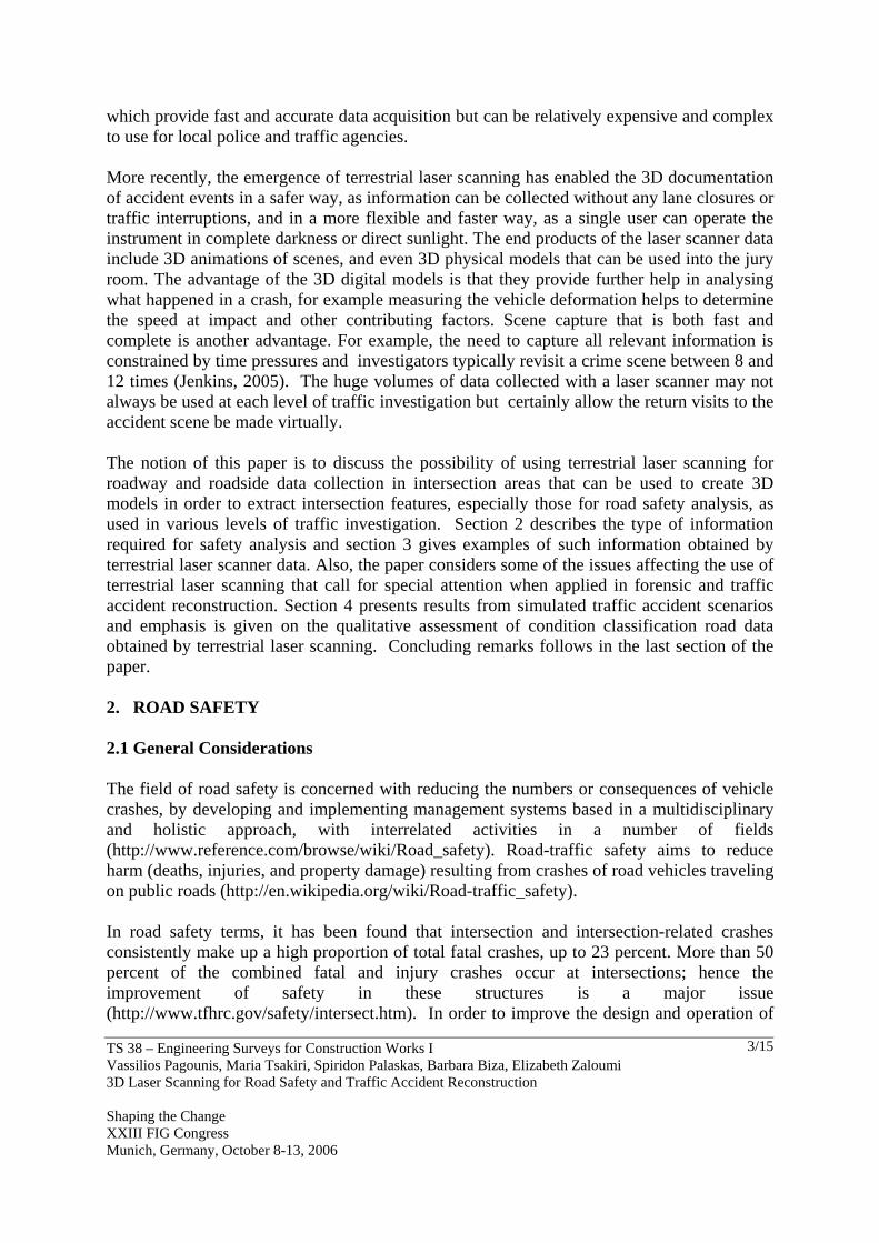
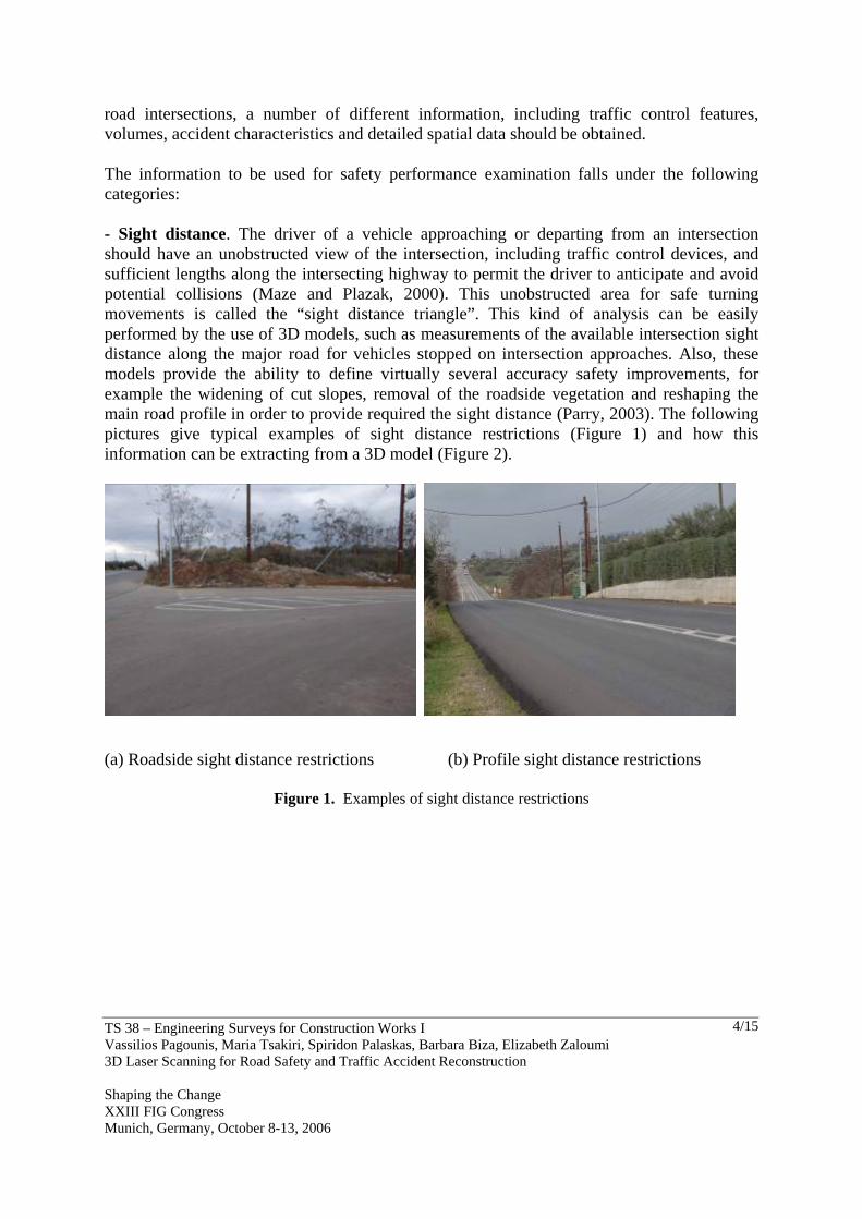
road intersections, a number of different information, including traffic control features, volumes, accident characteristics and detailed spatial data should be obtained. The information to be used for safety performance examination falls under the following categories: - Sight distance. The driver of a vehicle approaching or departing from an intersection should have an unobstructed view of the intersection, including traffic control devices, and sufficient lengths along the intersecting highway to permit the driver to anticipate and avoid potential collisions (Maze and Plazak, 2000). This unobstructed area for safe turning movements is called the “sight distance triangle”. This kind of analysis can be easily performed by the use of 3D models, such as measurements of the available intersection sight distance along the major road for vehicles stopped on intersection approaches. Also, these models provide the ability to define virtually several accuracy safety improvements, for example the widening of cut slopes, removal of the roadside vegetation and reshaping the main road profile in order to provide required the sight distance (Parry, 2003). The following pictures give typical examples of sight distance restrictions (Figure 1) and how this information can be extracting from a 3D model (Figure 2).
(a) Roadside sight distance restrictions (b) Profile sight distance restrictions
Figure 1. Examples of sight distance restrictions
TS 38 – Engineering Surveys for Construction Works I Vassilios Pagounis, Maria Tsakiri, Spiridon Palaskas, Barbara Biza, Elizabeth Zaloumi 3D Laser Scanning for Road Safety and Traffic Accident Reconstruction Shaping the Change XXIII FIG Congress Munich, Germany, October 8-13, 2006
5/15
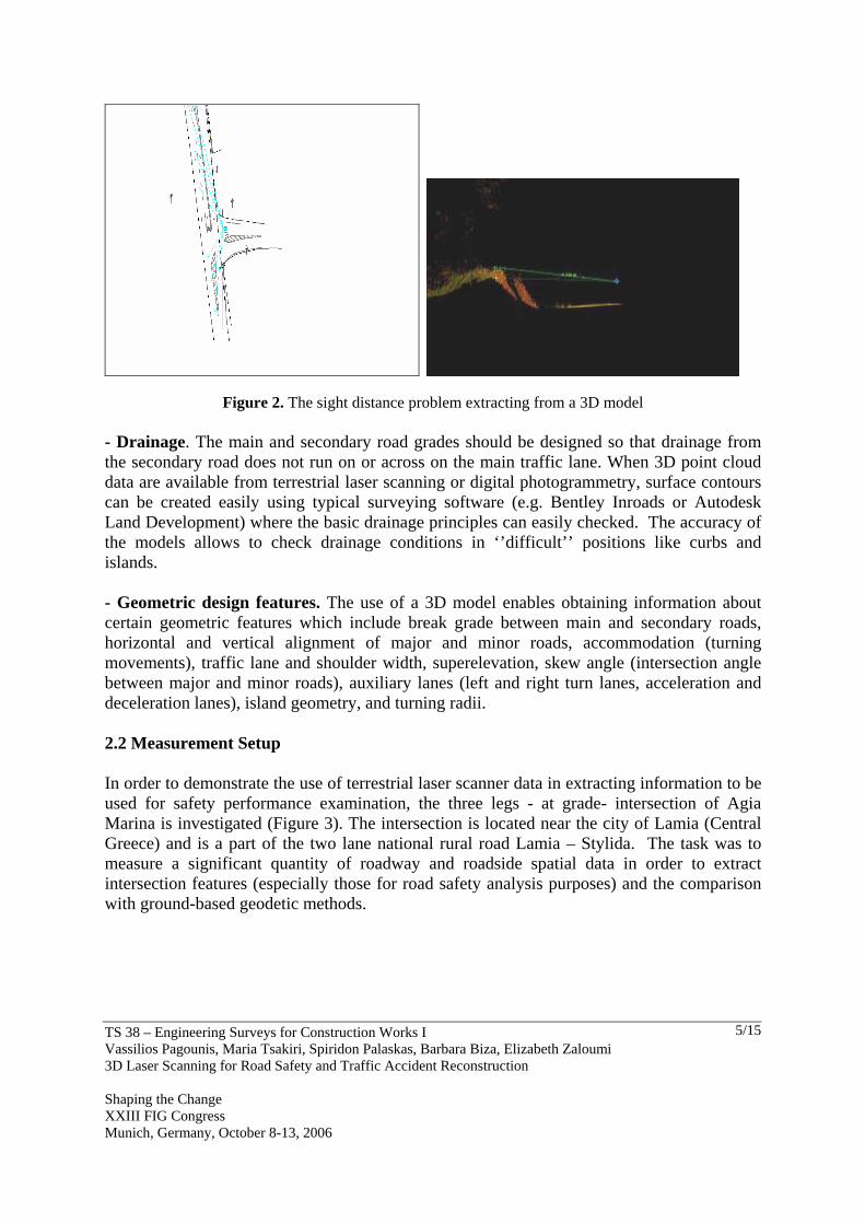
Figure 2. The sight distance problem extracting from a 3D model - Drainage. The main and secondary road grades should be designed so that drainage from the secondary road does not run on or across on the main traffic lane. When 3D point cloud data are available from terrestrial laser scanning or digital photogrammetry, surface contours can be created easily using typical surveying software (e.g. Bentley Inroads or Autodesk Land Development) where the basic drainage principles can easily checked. The accuracy of the models allows to check drainage conditions in ‘’difficult’’ positions like curbs and islands. - Geometric design features. The use of a 3D model enables obtaining information about certain geometric features which include break grade between main and secondary roads, horizontal and vertical alignment of major and minor roads, accommodation (turning movements), traffic lane and shoulder width, superelevation, skew angle (intersection angle between major and minor roads), auxiliary lanes (left and right turn lanes, acceleration and deceleration lanes), island geometry, and turning radii. 2.2 Measurement Setup In order to demonstrate the use of terrestrial laser scanner data in extracting information to be used for safety performance examination, the three legs - at grade- intersection of Agia Marina is investigated (Figure 3). The intersection is located near the city of Lamia (Central Greece) and is a part of the two lane national rural road Lamia – Stylida. The task was to measure a significant quantity of roadway and roadside spatial data in order to extract intersection features (especially those for road safety analysis purposes) and the comparison with ground-based geodetic methods.
TS 38 – Engineering Surveys for Construction Works I Vassilios Pagounis, Maria Tsakiri, Spiridon Palaskas, Barbara Biza, Elizabeth Zaloumi 3D Laser Scanning for Road Safety and Traffic Accident Reconstruction Shaping the Change XXIII FIG Congress Munich, Germany, October 8-13, 2006
6/15
Figure 3. Intersection of Agia Marina
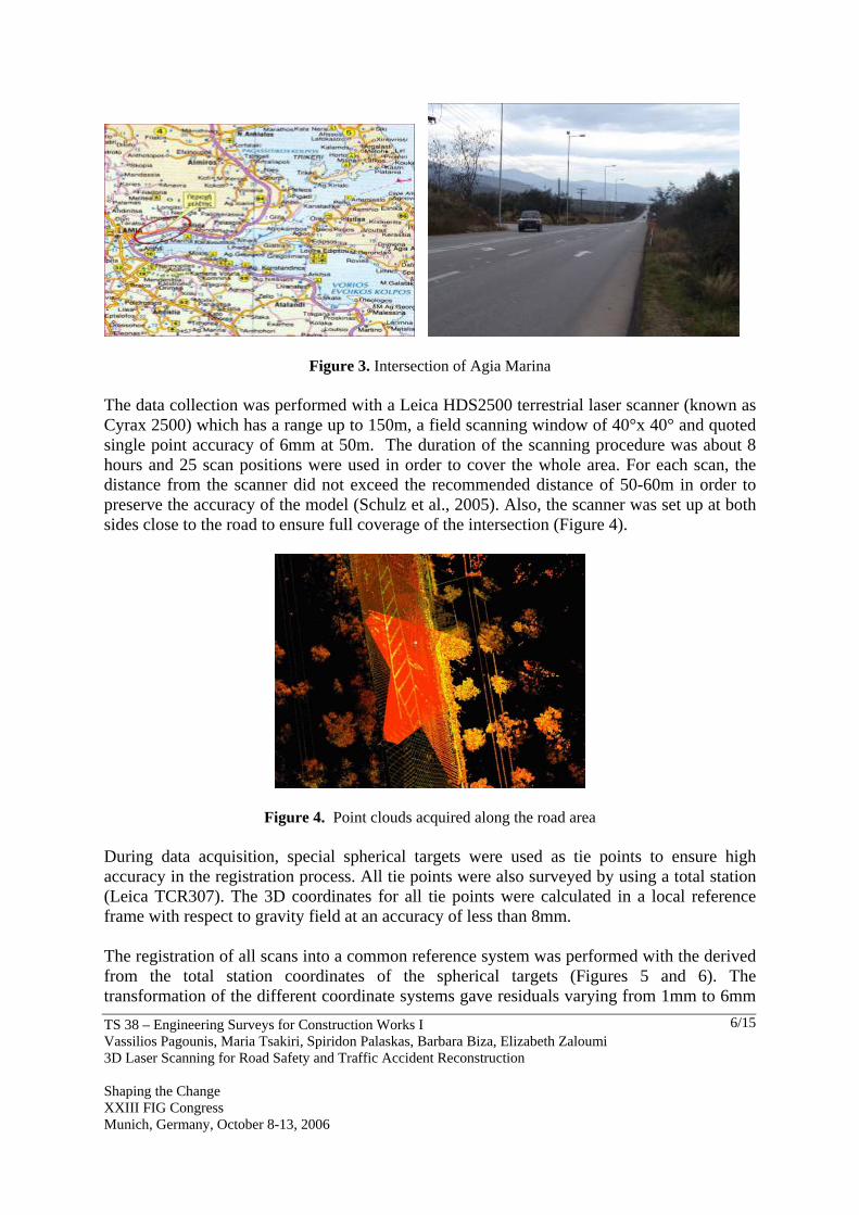
The data collection was performed with a Leica HDS2500 terrestrial laser scanner (known as Cyrax 2500) which has a range up to 150m, a field scanning window of 40°x 40° and quoted single point accuracy of 6mm at 50m. The duration of the scanning procedure was about 8 hours and 25 scan positions were used in order to cover the whole area. For each scan, the distance from the scanner did not exceed the recommended distance of 50-60m in order to preserve the accuracy of the model (Schulz et al., 2005). Also, the scanner was set up at both sides close to the road to ensure full coverage of the intersection (Figure 4).
Figure 4. Point clouds acquired along the road area
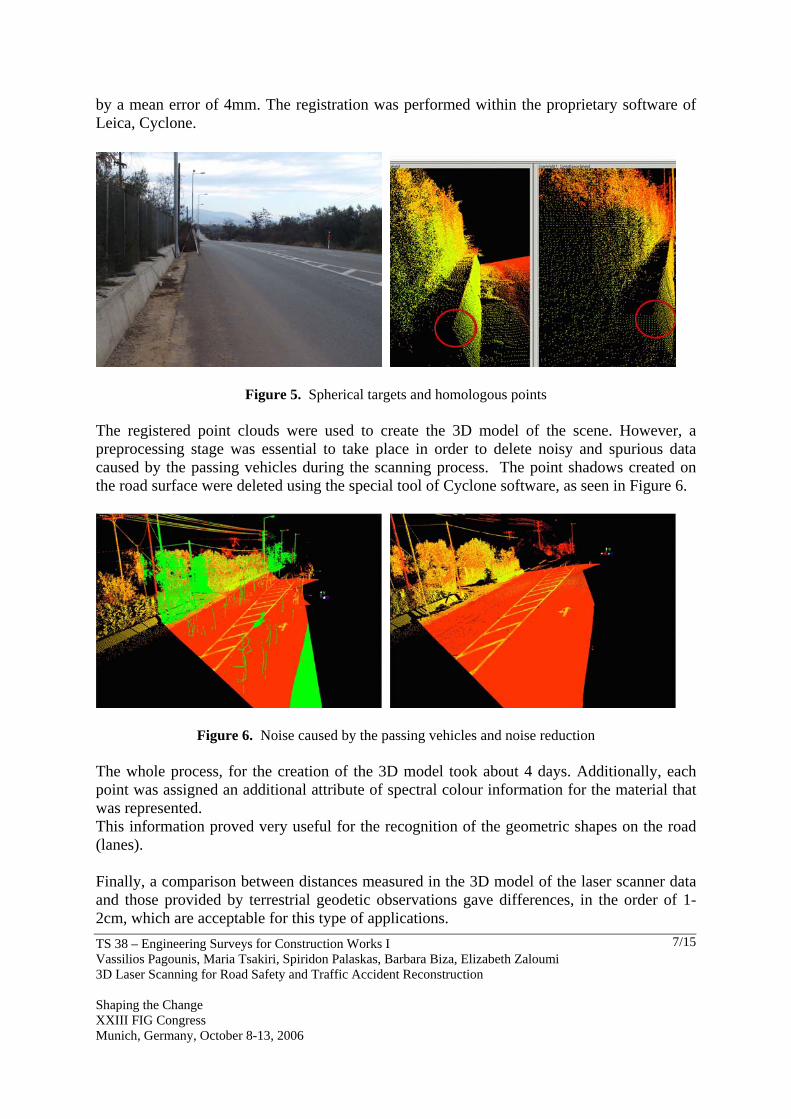
During data acquisition, special spherical targets were used as tie points to ensure high accuracy in the registration process. All tie points were also surveyed by using a total station (Leica TCR307). The 3D coordinates for all tie points were calculated in a local reference frame with respect to gravity field at an accuracy of less than 8mm. The registration of all scans into a common reference system was performed with the derived from the total station coordinates of the spherical targets (Figures 5 and 6). The transformation of the different coordinate systems gave residuals varying from 1mm to 6mm
TS 38 – Engineering Surveys for Construction Works I Vassilios Pagounis, Maria Tsakiri, Spiridon Palaskas, Barbara Biza, Elizabeth Zaloumi 3D Laser Scanning for Road Safety and Traffic Accident Reconstruction Shaping the Change XXIII FIG Congress Munich, Germany, October 8-13, 2006
7/15
by a mean error of 4mm. The registration was performed within the proprietary software of Leica, Cyclone.
Figure 5. Spherical targets and homologous points
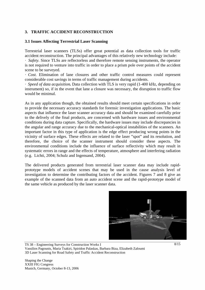
The registered point clouds were used to create the 3D model of the scene. However, a preprocessing stage was essential to take place in order to delete noisy and spurious data caused by the passing vehicles during the scanning process. The point shadows created on the road surface were deleted using the special tool of Cyclone software, as seen in Figure 6.
Figure 6. Noise caused by the passing vehicles and noise reduction The whole process, for the creation of the 3D model took about 4 days. Additionally, each point was assigned an additional attribute of spectral colour information for the material that was represented. This information proved very useful for the recognition of the geometric shapes on the road (lanes). Finally, a comparison between distances measured in the 3D model of the laser scanner data and those provided by terrestrial geodetic observations gave differences, in the order of 1-2cm, which are acceptable for this type of applications.
TS 38 – Engineering Surveys for Construction Works I Vassilios Pagounis, Maria Tsakiri, Spiridon Palaskas, Barbara Biza, Elizabeth Zaloumi 3D Laser Scanning for Road Safety and Traffic Accident Reconstruction Shaping the Change XXIII FIG Congress Munich, Germany, October 8-13, 2006
8/15
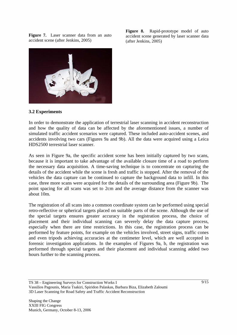
3. TRAFFIC ACCIDENT RECONSTRUCTION 3.1 Issues Affecting Terrestrial Laser Scanning Terrestrial laser scanners (TLSs) offer great potential as data collection tools for traffic accident reconstruction. The principal advantages of this relatively new technology include: · Safety. Since TLSs are reflectorless and therefore remote sensing instruments, the operator is not required to venture into traffic in order to place a prism pole over points of the accident scene to be surveyed. · Cost. Elimination of lane closures and other traffic control measures could represent considerable cost savings in terms of traffic management during accidents. · Speed of data acquisition. Data collection with TLS is very rapid (1-400 kHz, depending on instrument) so, if in the event that lane a closure was necessary, the disruption to traffic flow would be minimal. As in any application though, the obtained results should meet certain specifications in order to provide the necessary accuracy standards for forensic investigation applications. The basic aspects that influence the laser scanner accuracy data and should be examined carefully prior to the delively of the final products, are concerned with hardware issues and environmental conditions during data capture. Specifically, the hardware issues may include discrepancies in the angular and range accuracy due to the mechanical-optical instabilities of the scanners. An important factor in this type of application is the edge effect producing wrong points in the vicinity of surface edges. These effects are related to the laser ”spot” and its resolution, and therefore, the choice of the scanner instrument should consider these aspects. The environmental conditions include the influence of surface reflectivity which may result in systematic errors in range and the effects of temperature, atmosphere and interfering radiation (e.g. Lichti, 2004; Schulz and Ingensand, 2004). The delivered products generated from terrestrial laser scanner data may include rapid-prototype models of accident scenes that may be used in the cause analysis level of investigation to determine the contributing factors of the accident. Figures 7 and 8 give an example of the scanned data from an auto accident scene and the rapid-prototype model of the same vehicle as produced by the laser scanner data.
TS 38 – Engineering Surveys for Construction Works I Vassilios Pagounis, Maria Tsakiri, Spiridon Palaskas, Barbara Biza, Elizabeth Zaloumi 3D Laser Scanning for Road Safety and Traffic Accident Reconstruction Shaping the Change XXIII FIG Congress Munich, Germany, October 8-13, 2006
9/15
Figure 7. Laser scanner data from an auto accident scene (after Jenkins, 2005)
Figure 8. Rapid-prototype model of auto accident scene generated by laser scanner data (after Jenkins, 2005)
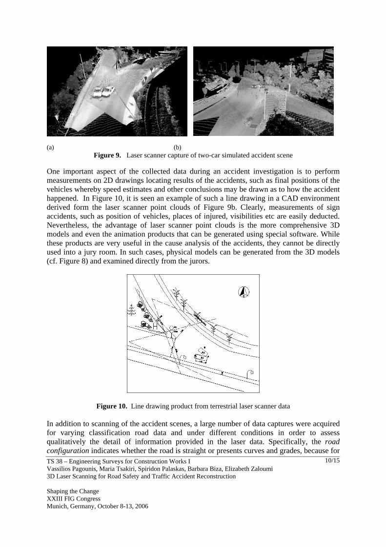
3.2 Experiments In order to demonstrate the application of terrestrial laser scanning in accident reconstruction and how the quality of data can be affected by the aforementioned issues, a number of simulated traffic accident scenarios were captured. These included auto-accident scenes, and accidents involving two cars (Figures 9a and 9b). All the data were acquired using a Leica HDS2500 terrestrial laser scanner. As seen in Figure 9a, the specific accident scene has been initially captured by two scans, because it is important to take advantage of the available closure time of a road to perform the necessary data acquisition. A time-saving technique is to concentrate on capturing the details of the accident while the scene is fresh and traffic is stopped. After the removal of the vehicles the data capture can be continued to capture the background data to infill. In this case, three more scans were acquired for the details of the surrounding area (Figure 9b). The point spacing for all scans was set to 2cm and the average distance from the scanner was about 10m. The registration of all scans into a common coordinate system can be performed using special retro-reflective or spherical targets placed on suitable parts of the scene. Although the use of the special targets ensures greater accuracy in the registration process, the choice of placement and their individual scanning can severely delay the data capture process, especially when there are time restrictions. In this case, the registration process can be performed by feature points, for example on the vehicles involved, street signs, traffic cones and even tripods achieving accuracies at the centimeter level, which are well accepted in forensic investigation applications. In the examples of Figures 9a, b, the registration was performed through special targets and their placement and individual scanning added two hours further to the scanning process.
TS 38 – Engineering Surveys for Construction Works I Vassilios Pagounis, Maria Tsakiri, Spiridon Palaskas, Barbara Biza, Elizabeth Zaloumi 3D Laser Scanning for Road Safety and Traffic Accident Reconstruction Shaping the Change XXIII FIG Congress Munich, Germany, October 8-13, 2006
10/15
(a) (b) Figure 9. Laser scanner capture of two-car simulated accident scene
One important aspect of the collected data during an accident investigation is to perform measurements on 2D drawings locating results of the accidents, such as final positions of the vehicles whereby speed estimates and other conclusions may be drawn as to how the accident happened. In Figure 10, it is seen an example of such a line drawing in a CAD environment derived form the laser scanner point clouds of Figure 9b. Clearly, measurements of sign accidents, such as position of vehicles, places of injured, visibilities etc are easily deducted. Nevertheless, the advantage of laser scanner point clouds is the more comprehensive 3D models and even the animation products that can be generated using special software. While these products are very useful in the cause analysis of the accidents, they cannot be directly used into a jury room. In such cases, physical models can be generated from the 3D models (cf. Figure 8) and examined directly from the jurors.
Figure 10. Line drawing product from terrestrial laser scanner data In addition to scanning of the accident scenes, a large number of data captures were acquired for varying classification road data and under different conditions in order to assess qualitatively the detail of information provided in the laser data. Specifically, the road configuration indicates whether the road is straight or presents curves and grades, because for
TS 38 – Engineering Surveys for Construction Works I Vassilios Pagounis, Maria Tsakiri, Spiridon Palaskas, Barbara Biza, Elizabeth Zaloumi 3D Laser Scanning for Road Safety and Traffic Accident Reconstruction Shaping the Change XXIII FIG Congress Munich, Germany, October 8-13, 2006
11/15
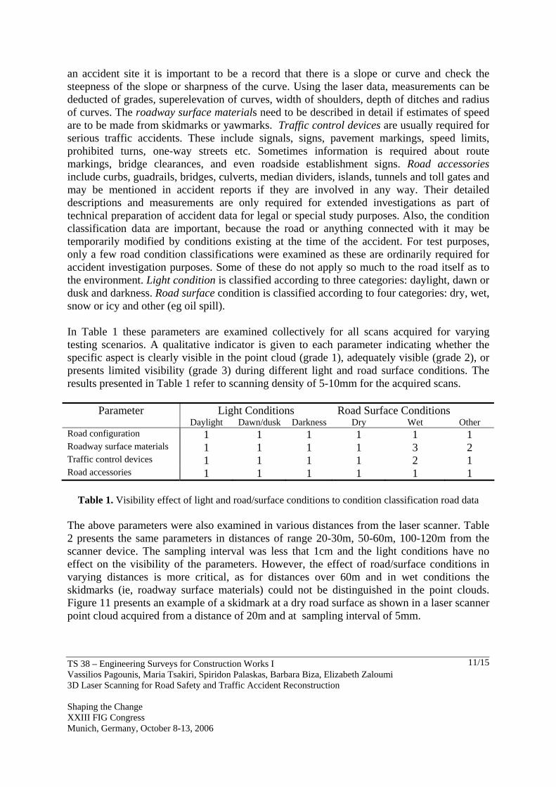
an accident site it is important to be a record that there is a slope or curve and check the steepness of the slope or sharpness of the curve. Using the laser data, measurements can be deducted of grades, superelevation of curves, width of shoulders, depth of ditches and radius of curves. The roadway surface materials need to be described in detail if estimates of speed are to be made from skidmarks or yawmarks. Traffic control devices are usually required for serious traffic accidents. These include signals, signs, pavement markings, speed limits, prohibited turns, one-way streets etc. Sometimes information is required about route markings, bridge clearances, and even roadside establishment signs. Road accessories include curbs, guadrails, bridges, culverts, median dividers, islands, tunnels and toll gates and may be mentioned in accident reports if they are involved in any way. Their detailed descriptions and measurements are only required for extended investigations as part of technical preparation of accident data for legal or special study purposes. Also, the condition classification data are important, because the road or anything connected with it may be temporarily modified by conditions existing at the time of the accident. For test purposes, only a few road condition classifications were examined as these are ordinarily required for accident investigation purposes. Some of these do not apply so much to the road itself as to the environment. Light condition is classified according to three categories: daylight, dawn or dusk and darkness. Road surface condition is classified according to four categories: dry, wet, snow or icy and other (eg oil spill). In Table 1 these parameters are examined collectively for all scans acquired for varying testing scenarios. A qualitative indicator is given to each parameter indicating whether the specific aspect is clearly visible in the point cloud (grade 1), adequately visible (grade 2), or presents limited visibility (grade 3) during different light and road surface conditions. The results presented in Table 1 refer to scanning density of 5-10mm for the acquired scans.
Parameter Light Conditions Road Surface Conditions Daylight Dawn/dusk Darkness Dry Wet Other Road configuration 1 1 1 1 1 1 Roadway surface materials 1 1 1 1 3 2 Traffic control devices 1 1 1 1 2 1 Road accessories 1 1 1 1 1 1
Table 1. Visibility effect of light and road/surface conditions to condition classification road data The above parameters were also examined in various distances from the laser scanner. Table 2 presents the same parameters in distances of range 20-30m, 50-60m, 100-120m from the scanner device. The sampling interval was less that 1cm and the light conditions have no effect on the visibility of the parameters. However, the effect of road/surface conditions in varying distances is more critical, as for distances over 60m and in wet conditions the skidmarks (ie, roadway surface materials) could not be distinguished in the point clouds. Figure 11 presents an example of a skidmark at a dry road surface as shown in a laser scanner point cloud acquired from a distance of 20m and at sampling interval of 5mm.
TS 38 – Engineering Surveys for Construction Works I Vassilios Pagounis, Maria Tsakiri, Spiridon Palaskas, Barbara Biza, Elizabeth Zaloumi 3D Laser Scanning for Road Safety and Traffic Accident Reconstruction Shaping the Change XXIII FIG Congress Munich, Germany, October 8-13, 2006
12/15
Figure 11. Example of a skidmark in a point cloud acquired at a distance of 20m from the laser scanner
Similarly to Table 1, a qualitative indicator is given to each parameter indicating whether this is clearly visible in the point cloud (grade 1), adequately visible (grade 2), or presents limited visibility (grade 3) at varying distances. The results presented in Table 2 refer to scanning density of the acquired scans of 5-10mm.
Parameter Distance from Laser Scanner 20-30m 50-60m 100-120m Road configuration 1 1 1 Roadway surface materials 1 3 3 Traffic control devices 1 1 2 Road accessories 1 1 2
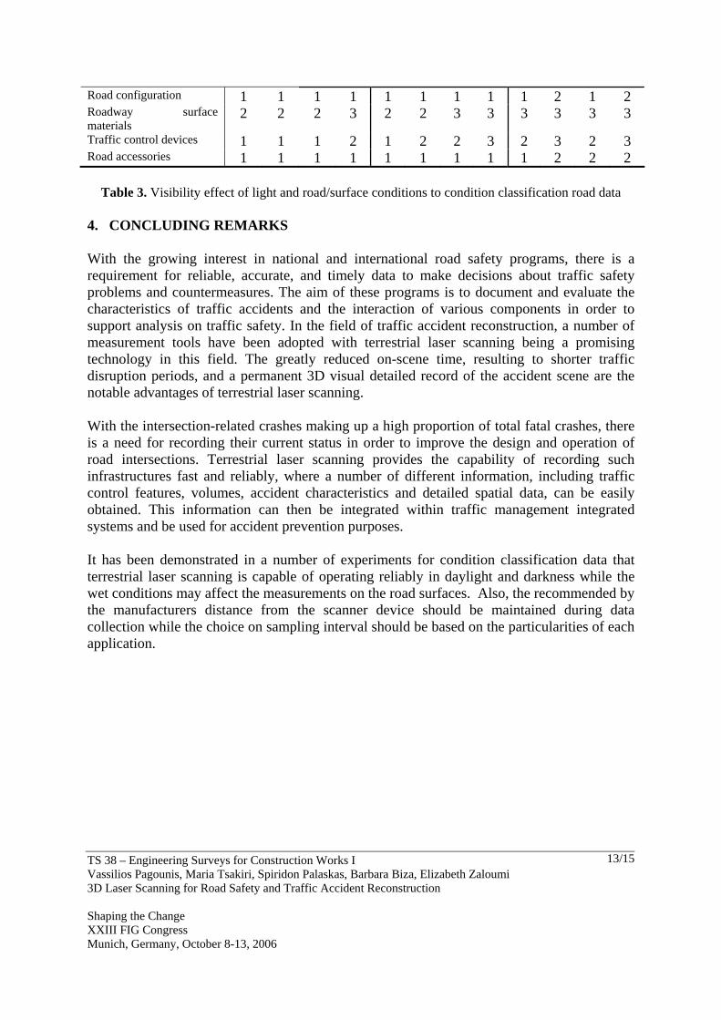
Table 2. Visibility effect of distance from laser scanner to condition classification road data Finally, the visibility of the same parameters was assessed within the laser scans of varying sampling interval in typical distances of 50m from the scanner device. Table 3 presents qualitatively the effect of sampling interval during data acquisition and in light conditions of daylight /darkness and road surface conditions of dry/wet. Similarly to the previous tables, a qualitative indicator is given to each parameter indicating whether this is clearly visible in the point cloud (grade 1), adequately visible (grade 2), or presents limited visibility (grade 3) at varying densities. As can be suggested by Table 3, when the sampling interval is over 7cm the resolution of the discussed parameters becomes poor and may affect the subsequent measurements.
Parameter Sampling Interval 5-10mm 10-25mm 50-70mm
Daylight Darkness Daylight Darkness Daylight Darkness Dry Wet Dry Wet Dry Wet Dry Wet Dry Wet Dry Wet
TS 38 – Engineering Surveys for Construction Works I Vassilios Pagounis, Maria Tsakiri, Spiridon Palaskas, Barbara Biza, Elizabeth Zaloumi 3D Laser Scanning for Road Safety and Traffic Accident Reconstruction Shaping the Change XXIII FIG Congress Munich, Germany, October 8-13, 2006
13/15
Road configuration 1 1 1 1 1 1 1 1 1 2 1 2 Roadway surface materials
2 2 2 3 2 2 3 3 3 3 3 3
Traffic control devices 1 1 1 2 1 2 2 3 2 3 2 3 Road accessories 1 1 1 1 1 1 1 1 1 2 2 2
Table 3. Visibility effect of light and road/surface conditions to condition classification road data 4. CONCLUDING REMARKS With the growing interest in national and international road safety programs, there is a requirement for reliable, accurate, and timely data to make decisions about traffic safety problems and countermeasures. The aim of these programs is to document and evaluate the characteristics of traffic accidents and the interaction of various components in order to support analysis on traffic safety. In the field of traffic accident reconstruction, a number of measurement tools have been adopted with terrestrial laser scanning being a promising technology in this field. The greatly reduced on-scene time, resulting to shorter traffic disruption periods, and a permanent 3D visual detailed record of the accident scene are the notable advantages of terrestrial laser scanning. With the intersection-related crashes making up a high proportion of total fatal crashes, there is a need for recording their current status in order to improve the design and operation of road intersections. Terrestrial laser scanning provides the capability of recording such infrastructures fast and reliably, where a number of different information, including traffic control features, volumes, accident characteristics and detailed spatial data, can be easily obtained. This information can then be integrated within traffic management integrated systems and be used for accident prevention purposes. It has been demonstrated in a number of experiments for condition classification data that terrestrial laser scanning is capable of operating reliably in daylight and darkness while the wet conditions may affect the measurements on the road surfaces. Also, the recommended by the manufacturers distance from the scanner device should be maintained during data collection while the choice on sampling interval should be based on the particularities of each application.
TS 38 – Engineering Surveys for Construction Works I Vassilios Pagounis, Maria Tsakiri, Spiridon Palaskas, Barbara Biza, Elizabeth Zaloumi 3D Laser Scanning for Road Safety and Traffic Accident Reconstruction Shaping the Change XXIII FIG Congress Munich, Germany, October 8-13, 2006
14/15
REFERENCES ANSI D 16.1 (1983). Manual on classification of motor vehicle traffic accidents. National
Safety Council, Chicago IL 60611, p. 43. Duignan, P., M. Griffiths and A. Lie (1996). Photogrammetric Methods in Crash
Investigation. Proceedings of the 15th International Technical Conference on Enhanced Safety of Vehicles, May 13-26, Melbourne, Australia, pp. 1514-1518.
Fraser C.S. and H.B. Hanley (2004). Developments in close-range phtogrammetry for 3D modeling: the iWitness example. In Proc. of International Workshop “Processing and visualization using high-resolution imagery”, 18-20 Nov., Pitsanulok, Thailand.
Jenkins B. (2005) Laser scanner for forensic investigation. www.spallc.com, 22/06/2005. Maze, T. and D. Plazak (2000). Access Management Handbook: Balancing the
Demands on Our Roadways. Ames, Iowa: Center for Transportation Research and Education, Iowa State University.
Schulz T., H. Ingensand , M. Steiner (2005). Laser scanning and noise reduction applied to 3D road surface analysis. In Proc. of the Optical 3-D, Measurement techniques VII, 3-5 October, Vienna, Austria.
Parry I. and F. Marsh, (2003). Constructing detailed road surfaces for vehicle dynamics simulation using 3D laser scanning techniques, Transport Research Laboratory (TRL Limited) United Kingdom.
BIOGRAPHICAL NOTES Dr Vassilios Pagounis is currently an Associate Professor at the Department of Topography Engineering of the Technological Educational Institution of Athens in Greece. He obtained his PhD in 2000 from the National Technical University of Athens (NTUA) in Greece. Dr Maria Tsakiri is currently an Assistant Professor at the School of Surveying Engineering of the NTUA in Greece. She obtained her PhD in 1996 from the University of Nottingham in UK. She is chairman of the FIG Task Force 6.1.5 “Terrestrial laser scanning in deformation monitoring”. Spiridon Palaskas is a research assistant at the Department of Topography of the Technological Educational Institution of Athens in Greece. He obtained his Master in Geoinformatics in 2004 from the NTUA and he is currently a PhD candidate (scholar of the Public Benefit Foundation Alexander S. Onassis) at the School of Surveying Engineering of the same university. Barbara Biza is a research assistant at the Laboratory of Geodesy-Topography of the Department of Topography of the Technological Educational Institution of Athens in Greece. She graduated from the Technological Educational Institution of Athens in 2005. Elizabeth Zaloumi is a final-year student of the Department of Topography of the Technological Educational Institution of Athens in Greece.

TS 38 – Engineering Surveys for Construction Works I Vassilios Pagounis, Maria Tsakiri, Spiridon Palaskas, Barbara Biza, Elizabeth Zaloumi 3D Laser Scanning for Road Safety and Traffic Accident Reconstruction Shaping the Change XXIII FIG Congress Munich, Germany, October 8-13, 2006
15/15
CONTACTS Dr Vassilios Pagounis Associate Professor Technological Educational Institution of Athens Ag. Spyridonos Egaleo 12210 GREECE Tel. + 30 2105385360 Fax + 30 2105385345 Email [email protected], [email protected]