3D SCANNING AND PHOTOGRAMMETRY FOR … tacheometry or close-range photogrammetry might be completely...
8
Geoinformatics 2004 Proc. 12th Int. Conf. on Geoinformatics − Geospatial Information Research: Bridging the Pacific and Atlantic University of Gävle, Sweden, 7-9 June 2004 291 3D SCANNING AND PHOTOGRAMMETRY FOR HERITAGE RECORDING: A COMPARISON W. Boehler and A. Marbs i3mainz, Institute for Spatial Information and Surveying Technology, Holzstrasse 36, 55116 Mainz, Germany, [email protected] Abstract There is a high demand in documentation of cultural heritage objects such as artifacts, sculptures or buildings. In the past years, laser scanning, or 3D scanning in general, has been used increasingly for cultural heritage recording and the question arose if this new method can replace traditional methods like close-range photogrammetry. To investigate the advantages and disadvantages of both methods, i3mainz has carried out some case studies for cultural heritage documentation. Different typical objects were chosen and characteristical parts of them were recorded both by photogrammetry and scanning. Documented objects include an archaeological stone wall, baroque relief plates, Stone Age artifacts, ancient statues and the façade of a classical castle. Besides 3D scanning all these examplary objects were also recorded with standard stereophotogrammetry which is the most popular heritage recording method so far. Results are usually line drawings, but the creation of orthophotos or digital surface models is possible, too. In this paper five case studies are shortly introduced and the results of both measurement techniques are presented and compared. The aim is to give users (especially those who are not surveying experts) recommendations, which method is suited best for what kind of application, or even if a combination of 3D scanning and photogrammetry is advisable. Criteria like quality of the results, amount of cost and time, required equipment and occurring problems are to be considered. INTRODUCTION In the past years 3D scanning techniques have gained much interest (also in the cultural heritage sector). Very optimistic people even predicted that traditional surveying methods like tacheometry or close-range photogrammetry might be completely replaced by 3D scanning in the future. But there is still a lot of misunderstanding and ignorance concerning this new method. Many potential users do not know in detail how 3D scanning works, which results can be expected and how much it costs. Therefore i3mainz, Institute for Spatial Information and Surveying Technology, decided to initiate a project with the aim to compare 3D scanning with the common measurement technique for complex heritage recording tasks: close-range photogrammetry. For this purpose, several typical objects in architecture, archaeology and cultural heritage were documented with both methods and compared regarding quality of results, accuracy, cost and other criteria. As a final result of these investigations, a guidebook was published to give users recommendations which technique is suited best for their applications. The publication (Marbs, 2004) will be handed out to German authorities for historical monuments and other institutions that are involved in heritage recording.
Transcript of 3D SCANNING AND PHOTOGRAMMETRY FOR … tacheometry or close-range photogrammetry might be completely...

Geoinformatics 2004Proc. 12th Int. Conf. on Geoinformatics − Geospatial Information Research: Bridging the Pacific and Atlantic
University of Gävle, Sweden, 7-9 June 2004
291
3D SCANNING AND PHOTOGRAMMETRY FOR HERITAGERECORDING: A COMPARISON
W. Boehler and A. Marbsi3mainz, Institute for Spatial Information and Surveying Technology, Holzstrasse 36, 55116 Mainz, Germany,
AbstractThere is a high demand in documentation of cultural heritage objects such as artifacts,sculptures or buildings. In the past years, laser scanning, or 3D scanning in general, hasbeen used increasingly for cultural heritage recording and the question arose if this newmethod can replace traditional methods like close-range photogrammetry. To investigatethe advantages and disadvantages of both methods, i3mainz has carried out some casestudies for cultural heritage documentation. Different typical objects were chosen andcharacteristical parts of them were recorded both by photogrammetry and scanning.Documented objects include an archaeological stone wall, baroque relief plates, Stone Ageartifacts, ancient statues and the façade of a classical castle. Besides 3D scanning all theseexamplary objects were also recorded with standard stereophotogrammetry which is themost popular heritage recording method so far. Results are usually line drawings, but thecreation of orthophotos or digital surface models is possible, too.
In this paper five case studies are shortly introduced and the results of both measurementtechniques are presented and compared. The aim is to give users (especially those who arenot surveying experts) recommendations, which method is suited best for what kind ofapplication, or even if a combination of 3D scanning and photogrammetry is advisable.Criteria like quality of the results, amount of cost and time, required equipment andoccurring problems are to be considered.
INTRODUCTIONIn the past years 3D scanning techniques have gained much interest (also in the culturalheritage sector). Very optimistic people even predicted that traditional surveying methodslike tacheometry or close-range photogrammetry might be completely replaced by 3Dscanning in the future. But there is still a lot of misunderstanding and ignorance concerningthis new method. Many potential users do not know in detail how 3D scanning works,which results can be expected and how much it costs.
Therefore i3mainz, Institute for Spatial Information and Surveying Technology, decided toinitiate a project with the aim to compare 3D scanning with the common measurementtechnique for complex heritage recording tasks: close-range photogrammetry. For thispurpose, several typical objects in architecture, archaeology and cultural heritage weredocumented with both methods and compared regarding quality of results, accuracy, costand other criteria. As a final result of these investigations, a guidebook was published togive users recommendations which technique is suited best for their applications. Thepublication (Marbs, 2004) will be handed out to German authorities for historicalmonuments and other institutions that are involved in heritage recording.

W. Boehler and A. Marbs
292
This paper is a condensed version of the guidebook (which amounts to approx. 50 pages)and will give a short overview about the case studies and the measurement technologiesused for these projects. In the end, the experiences and insights will be summarized to afinal conclusion.
TECHNOLOGY
3D Scanning3D scanning (often called laser scanning) is a surface-based three-dimensionalmeasurement technique. One scan results in a large quantity of points in a systematicpattern – also called point cloud (Boehler and Marbs, 2002). Final results after processingof the raw data can be line drawings, CAD models, 3D surface models (with artificial orphotorealistic textures) or video animations.
Many different systems are on the market for all kinds of object sizes, ranges andaccuracies. 3D scanners are already used in industry (e.g. automotive, clothing) for design,development, quality control and rapid prototyping as well as in engineering andconstruction for the documentation of plants, buildings and landscapes. But 3D scanningoffers new possibilities for the recording of objects in archaeology, architecture and culturalheritage as well, which is the main aspect of this paper.
For the case studies, three different scanners were used: The GOM ATOS II is a structuredlight digitizer for small objects. It captures a maximum scanning volume of 1 m³ withaccuracies of 0.02 mm and better. The MENSI S25 is a triangulation type laser scanner thatworks best at ranges of 2 to 10 meters with accuracies between 0.5 and 2 mm. Leica’s HDS2500 ranging laser scanner (former Cyrax 2500) is able to scan objects up to 100 m with asingle point accuracy of 4 mm.
In addition to a relatively expensive scanner (typically between € 50,000 and € 200,000), aproper software kit is needed to process the raw point data and to achieve satisfactoryresults. Normally, the scanner manufacturers provide their own software which might beadequate. But often this is not the case and an additional software package has to bepurchased. Different stand-alone products are available. Some focus on fitting features andthe creation of CAD models, others are primarily specializing in mesh creation. The latter isusually the appropriate method for heritage objects. A detailed list of scanner hardware andsoftware can be found at i3mainz (2004).
Close-range photogrammetryAnalytical stereophotogrammetry is still the predominant method for the geometricdocumentation of complex heritage objects. Analogue film contains a maximum ofinformation and can be archived for a long time. Analytical plotters for aerial photographscan be used for close-range applications in the same way. Any camera can be used forphotogrammetric purposes, from low-cost 35 mm cameras to high-end large format metriccameras. But depending on the accuracy requirements, the camera should meet certaincriteria like a stable interior orientation.
A camera like the Rolleiflex 6008 metric middle format camera, which was used for thecase studies, is a good compromise. It is equipped with exchangeable metric lenses and abuilt-in grid (réseau) plate with 11 x 11 reference crosses. The camera is calibrated by themanufacturer for each lens and can therefore be used for any close-range photogrammetric

3D scanning and photogrammetry for heritage recording: a comparison
293
application. With a total cost of about € 10,000 (including lens) it is an affordableinvestment. The result of photogrammetric plotting is usually a line drawing in 2D or 3D ina CAD system. This can be used as the basis for restoration, visualization or furtherinvestigations.
CASE STUDIES
Stone wall with archaeological findingsNearly 2000 years ago, the Romans started to mine the huge tuff deposit in the EasternEifel which originate from the eruption of the Lacher-See volcano 13,000 years ago. Eventoday, the tuff is mined there, thus most of the ancient quarries were destroyed. But an areaof 3,000 m² was roofed and protected against further destruction. Today tourists can visitsingle mining walls and inspect the underground workplace of the Romans. One of thosetuff stone walls (size 4.5 x 3 m²) was documented with laser scanning and photogrammetry.It was demanded that special working traces like wedge holes, cuts and tool marks shouldbe clearly perceptible in the recordings.
A MENSI S25 laser scanner was used to record the wall with an accuracy of 1 to 2 mm. Aregular point grid of 5 mm was chosen for the whole wall and 2 mm for interesting areaslike the working traces. Since the scanner achieves its highest accuracy at short distances (2to 3 m) and space in front of the wall was limited, the scanner was not able to capture thewhole wall in one shot. Scans from three different observation points had to be carried outand were connected using small spheres which were distributed around the scanning site.The final registered point cloud was used to create a closed surface mesh for visualizationpurposes (Figure 1).
Figure 1: Screenshots of a video animation of the stone wall.
The photogrammetric work was accomplished simultaneously with a Rolleiflex 6008metric middle format camera. The use of a 50 mm lens allowed image scales of 1:60 whichis by far enough to achieve a final output scale of 1:20. Twelve images were taken for sixstereo pairs. For the exterior orientation of the models, 15 reference targets had to be co-ordinated using a total station. The final result after approximately three hours ofstereocompilation on a Zeiss P3 Planicomp stereo plotter is a vector map and can be seen inFigure 2.
This project is a typical example for heritage recording, where 3D scanning yields betterresults than photogrammetric techniques (within a comparable time). A 3D model of thestone wall contains by far more information than a line drawing and conveys the three-dimensional shape of the wall much better. The vector map only shows the most importantfeatures and edges and does not provide any information about the areas between the lines.

W. Boehler and A. Marbs
294
Figure 2: Vector map of the stone wall.
Façade of a classical castleClose-range photogrammetry is the typical method for the documentation of façades.Already shortly after the invention of photography in the middle of the 19th century, peoplestarted to develop cameras and measurement techniques for the purpose of conservation,restoration and documentation of architecture. But nowadays, laser scanners also measurecontact-free and nearly as fast as photogrammetry and thus can be an alternative solution.
The castle ‘Schloss Herrnsheim’ near Worms, Germany, was used as an exemplary objectfor the comparison of both methods. This castle was built in the 15th century and got itspresent shape around 1840. The recorded façade is 34 m wide and 13 m high and wasdocumented with the aim of creating a three-dimensional vector map. Six images weretaken with a Rollei 6008 for the stereocompilation. Three to four days of work on the stereoplotter resulted in a line drawing that can be seen in Figure 3.
Figure 3: Line drawing of Schloss Herrnsheim.
Scanning was accomplished with a Cyrax 2500 laser scanner. Within two hours of scanningfrom three observation points, the whole façade was captured using an average pointdensity of 15 mm. After the registration of the three scans, a plugin allowed the loading ofthe resulting 2.7 million points into AutoCAD. Then a line drawing was created on thebasis of the snapped 3D points. This procedure is very time-consuming, because the pointcloud has to be rotated permanently to get a 3D impression and to be able to snap the

3D scanning and photogrammetry for heritage recording: a comparison
295
correct points (e.g. on edges). In any case, the resulting lines will have certain deviationsfrom their correct positions due to the point density of the laser scans.
The line drawing originating from this procedure is similar to the stereoplotting results, butcontains less information. For instance, it is not possible to detect the joints in the brick-work, which can easily be measured with a stereo plotter. The amount of time for process-ing the data to a final line drawing is much the same for both methods. But it has to be con-sidered that the scanning results are of lower quality regarding accuracy and level of detail.
But 3D scanning offers other interesting applications, for example a deformation analysis.The result in Figure 4 shows the deviations of the scanned wall from a reference plane.
Figure 4: Deformation analysis.
Renaissance relief plateThe Hofkirche at Innsbruck with the tomb of Emperor Maximilian I is probably the mostimportant art-historical monument in the State of Tyrol. The cuboid shaped cenotaph(empty tomb) consists of a frame of black marble in which 24 reliefs of white marble (eachapprox. 82 cm x 55 cm) are embedded in two horizontal rows around the object. Thesereliefs show scenes of Emperor Maximilian’s life. They have a level of detail within therange of 0.1 mm and had to be documented down to the smallest detail and with the highestprecision available. Due to the uniqueness of the object, a combination of surveyingmethods was applied. Both, close-range photogrammetry and high-accuracy 3D scanningwere used.
Due to the complexity of the object, each plate was captured with 12 to 33 scans with aGOM Atos II light projection digitizer. Up to 25 million points were recorded per plate.This amount of data had to be reduced intelligently, because current software products donot allow the handling of more than a few million points. After triangulation of the points,the resulting mesh had to be edited manually to reduce noise and to fill holes in hiddenparts of the surface (e.g. behind arms, swords etc.). The whole postprocessing work tookabout one week for each relief plate.
The photogrammetric work was done with a UMK 1318 large format metric camera. Thestereocompilation of two stereo pairs per relief plate also took about one week. In Figure 5a comparison of photo, line drawing and 3D model is shown, which gives a goodimpression about the level of detail of these representations of the relief. Thephotogrammetric vector map is not suited to get a real three-dimensional impression of theobject. It only contains the most important contours and feature lines. The 3D model, on the

W. Boehler and A. Marbs
296
other hand, comprises a virtual copy of the original relief plate with only little loss ofinformation and detail. See also Boehler et al. (2003b).
Figure 5: Part of a relief plate (about 10 cm x 10 cm): Photo, line drawing, 3D model.
Archaeological artifactsUp to now the documentation of Stone Age artifacts is usually confined to manualdrawings. Characteristical parts like tool marks or concave and convex faces have to behighlighted by shading. But this method does not contain any true 3D information and isvery time-consuming. Innovative solutions are desirable for a more automatic documen-tation of archaeological artifacts.
For this purpose, a Stone Age hand-axe was recorded with both, a GOM Atos II scannerand a Rollei 6006 camera. A procedure was developed that allows the creation of a closed3D surface model within 45 minutes, including the scanning time. The stereo plotting ofboth sides of the artifact using the Rollei imagery took about four hours. Results of bothmethods can be seen in Figure 6. See Boehler et al. (2003a) for more information on thisproject.
Figure 6: Stone Age artifact (about 11 cm x 4 cm): Photo, line drawing, 3D model.
3D scanning offers new possibilities for analyzing archaeological findings. Once scanned,those findings are available as a digital copy (e.g. via internet) worldwide. At present,algorithms are in development at i3mainz for an automatic extraction of characteristicaldimensions (e.g. sizes, volumes) and features like edges, concave and convex surfaces.
3D scanning and photogrammetry for heritage recording: a comparison
297
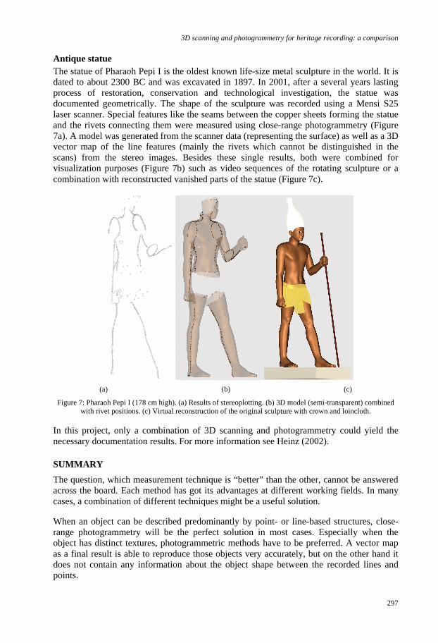
Antique statueThe statue of Pharaoh Pepi I is the oldest known life-size metal sculpture in the world. It isdated to about 2300 BC and was excavated in 1897. In 2001, after a several years lastingprocess of restoration, conservation and technological investigation, the statue wasdocumented geometrically. The shape of the sculpture was recorded using a Mensi S25laser scanner. Special features like the seams between the copper sheets forming the statueand the rivets connecting them were measured using close-range photogrammetry (Figure7a). A model was generated from the scanner data (representing the surface) as well as a 3Dvector map of the line features (mainly the rivets which cannot be distinguished in thescans) from the stereo images. Besides these single results, both were combined forvisualization purposes (Figure 7b) such as video sequences of the rotating sculpture or acombination with reconstructed vanished parts of the statue (Figure 7c).
(a) (b) (c)
Figure 7: Pharaoh Pepi I (178 cm high). (a) Results of stereoplotting. (b) 3D model (semi-transparent) combinedwith rivet positions. (c) Virtual reconstruction of the original sculpture with crown and loincloth.
In this project, only a combination of 3D scanning and photogrammetry could yield thenecessary documentation results. For more information see Heinz (2002).
SUMMARYThe question, which measurement technique is “better” than the other, cannot be answeredacross the board. Each method has got its advantages at different working fields. In manycases, a combination of different techniques might be a useful solution.
When an object can be described predominantly by point- or line-based structures, close-range photogrammetry will be the perfect solution in most cases. Especially when theobject has distinct textures, photogrammetric methods have to be preferred. A vector mapas a final result is able to reproduce those objects very accurately, but on the other hand itdoes not contain any information about the object shape between the recorded lines andpoints.

W. Boehler and A. Marbs
298
Instead of traditional line drawings, orthophotos might be alternative solutions for thedocumentation of flat, regular shaped objects like architectural façades. Besides geometricaccuracy, orthophotos contain radiometric information (gray or color values). But it shouldbe noted that orthophotos are always only two-dimensional.
Further advantages of photogrammetry for heritage recording are the short time needed forthe recording on site, particularly when no stable recording platform is available, and thestorage qualities of photographic film which can be archived for a long time.
On the other hand, 3D scanning techniques have to be preferred when very complex andirregular objects like sculptures, reliefs or archaeological findings are to be documented.Due to its surface-based working principle, those objects can be captured by 3D scannersvery accurately and in full detail. In addition the results of scanning projects can bepresented and visualized much better than the results of any other geodetic method. Byusing artificial illumination and surface textures for the visualization of 3D models,impressive realistic presentations can be achieved which are often more valuable forinspection than the original object itself (see Figure 5 left and right).
In many cases, a combination of scanning and photogrammetric techniques is the bestsolution. When both, line- and surface-based structures have to be captured, one singlemethod often does not produce satisfactory results.
ACKNOWLEDGEMENTSThe project was funded by the Federal German Government (BMBF) in its aFuE program(grant 170 26 02). G. Heinz from Roemisch-Germanisches Zentralmuseum, M. BordasVicent and C. Treber from i3mainz contributed data from their projects. The photogram-metric line drawing (Figure 5) was produced by Linsinger Vermessung, St. Johann, Austria.
REFERENCESBoehler, W., Boehm, K., Heinz, G., Justus, A., Schwarz, C. and Siebold, M., 2003a:
Documentation of Stone Age artifacts. The ISPRS International Archives ofPhotogrammetry, Remote Sensing and Spatial Information Sciences, Vol. 34, Part 5,506-510
Boehler, W., Bordas Vicent, M., Hanke, K. and Marbs, A., 2003b: Documentation of theGerman Emperor Maximilian I’s tomb. The ISPRS International Archives ofPhotogrammetry, Remote Sensing and Spatial Information Sciences, Vol. 34, Part 5,474-479
Boehler, W. and Marbs, A., 2002: 3D scanning instruments. CIPA – ISPRS workshop onscanning for cultural heritage recording, Corfu, Greece. http://www.isprs.org/commission5/workshop/
Heinz, G., 2002: Pharaoh Pepi I.: Documentation of the oldest known life-size metalsculpture using laser scanning and photogrammetry. CIPA – ISPRS workshop onscanning for cultural heritage recording, Corfu, Greece. http://www.isprs.org/commission5/workshop/
i3mainz, 2004: WEB site of i3mainz about 3D scanning in cultural heritage.http://scanning.fh-mainz.de/
Marbs, A., 2004: Vergleich von 3D-Scanning und Photogrammetrie zur geometrischenDokumentation im Denkmalbereich. Edited and published by i3mainz. In print.