37 no. 4 - American Rock Art Research Association
20
The Official Newsletter of the American Rock Art Research Association Member of the International Federation of Rock Art Organizations http://www.arara.org La Pintura Membership Year 2011 Volume 37, Number 4 December 2011 e ARARA 2012 Logo O ur logo for the upcoming conference is from a panel at Anasazi Ridge. This site is located in Santa Clara Canyon, west of St. George and Ivins, Utah, at a general location known as Land’s End to the BLM. Nearby are several Virgin Anasazi villages and their fields along the river bottom. Welcome to St. George! By Jeff Allen, Local Coordinator e Event ARARA’s 2012 annual conference will be held at the Lexington Hotel and Convention Center in St. George on Memorial Day Weekend, May 25-28. This venue provides large guest rooms and very convenient meeting rooms. Our conference room rate is $79.99, which includes a great full breakfast. Further details on the conference, making your reservations, registration, and abstract submittal are provided at www.arara.org. The call for papers is now open. Abstracts are due April 1, and must be submitted electronically. e Land and Its Rock Art Southwestern Utah is a land tortured by geology, flamboyant to the eyes, and a surprising palette for Native American rock artists over the centuries. Patinated red rock sandstone is abundant. Small rivers and creeks provided farming land for the Ancestral Puebloans who inhabited the area, only to abandon the land before the florescence of its culture. Formative petroglyphs were pecked sometimes in close proximity to western desert archaic panels with Paiute pictographs not far away. It has been a strange land for a long time. Once on the edge of the continent, beaches remain—small pebbles are cemented by conglomerate. Right on the edge of town, you can still see ancient beaches near the Santa Clara River with magnificent petroglyphs and the remains of pithouse villages at Anasazi Ridge. Dinosaurs were here, too, in shallow lake beds, leaving tracks that as recent as ten years ago have changed our understanding of early Jurassic paleontology. Visit our Dinosaur Museum while you are here. The Ancestral Puebloans knew some sort of beast had been here. Deep in Grand Staircase Escalante National Monument area there are dinosaur tracks, and below them, representations of the same tracks in the rock art. Volcanic activity also shaped the area. The Pine Valley Mountains just north of town rise 7,500 feet above the St. George Basin. Geologists say that the Pine Valley Mountains are the largest laccolithic mountains in the world, formed by a lava lake forced up below the layers of sandstone until the sandstone broke and eroded away. There is rock art here. Go to Peter’s Leap if you don’t mind uneven footing, and you’ll find hundreds of petroglyphs along a creek that cuts through this lava and, at the top of a pioneer dugway, spirals that were pecked hundreds of years ago. North from Cedar City, tectonic forces split open a ridge and formed Parowan Gap. Here, the Fremont people found a perfectly natural way of recording the seasons and the lunar cycle. At the summer solstice, the sun drops right ...continued on next page
Transcript of 37 no. 4 - American Rock Art Research Association

The Official Newsletter of the American Rock Art Research AssociationMember of the International Federation of Rock Art Organizations
http://www.arara.org
La Pintura Membership Year 2011Volume 37, Number 4
December 2011
The ARARA 2012 Logo
Our logo for the upcoming conference is from a panel at Anasazi Ridge. This site is located in Santa Clara
Canyon, west of St. George and Ivins, Utah, at a general location known as Land’s End to the BLM. Nearby are several Virgin Anasazi villages and their fields along the river bottom.
Welcome to St. George!By Jeff Allen, Local Coordinator
The Event ARARA’s 2012 annual conference will be held at the
Lexington Hotel and Convention Center in St. George on Memorial Day Weekend, May 25-28. This venue provides large guest rooms and very convenient meeting rooms. Our conference room rate is $79.99, which includes a great full breakfast. Further details on the conference, making your reservations, registration, and abstract submittal are provided at www.arara.org. The call for papers is now open. Abstracts are due April 1, and must be submitted electronically.
The Land and Its Rock Art Southwestern Utah is a land tortured by geology,
flamboyant to the eyes, and a surprising palette for Native American rock artists over the centuries. Patinated red rock sandstone is abundant. Small rivers and creeks provided farming land for the Ancestral Puebloans who inhabited the area, only to abandon the land before the florescence of its culture. Formative petroglyphs were pecked sometimes in close proximity to western desert archaic panels with Paiute pictographs not far away.
It has been a strange land for a long time. Once on the edge of the continent, beaches remain—small pebbles are cemented by conglomerate. Right on the edge of town, you can still see ancient beaches near the Santa Clara River with magnificent petroglyphs and the remains of pithouse villages at Anasazi Ridge. Dinosaurs were here, too, in shallow lake beds, leaving tracks that as recent as ten years ago have changed our understanding of early Jurassic paleontology. Visit our Dinosaur Museum while you are here. The Ancestral Puebloans knew some sort of beast had been here. Deep in Grand Staircase Escalante National Monument area there are dinosaur tracks, and below them, representations
of the same tracks in the rock art.Volcanic activity also shaped the area. The Pine Valley
Mountains just north of town rise 7,500 feet above the St. George Basin. Geologists say that the Pine Valley Mountains are the largest laccolithic mountains in the world, formed by a lava lake forced up below the layers of sandstone until the sandstone broke and eroded away. There is rock art here. Go to Peter’s Leap if you don’t mind uneven footing, and you’ll find hundreds of petroglyphs along a creek that cuts through this lava and, at the top of a pioneer dugway, spirals that were pecked hundreds of years ago.
North from Cedar City, tectonic forces split open a ridge and formed Parowan Gap. Here, the Fremont people found a perfectly natural way of recording the seasons and the lunar cycle. At the summer solstice, the sun drops right
...continued on next page

2 La Pintura December 2011
into the Gap. The winter solstice is recorded there, too, as are the equinoxes. Archaic petroglyphs in a lava cave have been dated to 5,000 B.C. And for the Paiutes, this is where Tabatz swallows the Sun between November and February. Not far off are petroglyphs in Bock’s Canyon, Spirit Ridge, and Black Point. The Fremont anthropomorphs at Black Point are exceptional. Are they a human counterpoint to the celestial activities recorded at Parowan Gap? What does that east-facing sky rock with its petroglyphs say?
West of Cedar City in Great Basin territory is Lion’s Mouth, a cave full of brilliant Paiute pictographs. My favorite is the Bird Shaman; it will make you a believer. On the Arizona Strip, in Paiute Cave, is another set of brilliant pictographs, polychrome arcs, and golden anthropomorphs. And in Zion National Park, Cave Valley is in a beautiful area where rice grass still grows, where smoke darkens the eroded slickrock, and where dozens of pictographs have been painted, sometimes superimposed. This is the site type for Cave Valley style rock art with its unique triangulate anthropomorphs. Look close and you’ll see couple of flute players playing into an anthropomorph’s ear.
They are not the only flute players around, for sure. South of Mesquite, in the Gold Butte area, are three flute players, one in a long headdress playing the flute while supine. Look for orange sandstone here, and you find petroglyphs: large public panels expertly pecked, and a lexicon of Ancestral Puebloan symbols for those who lived along the flood-prone Virgin River and the spring-fed Muddy River.
To the east of the St. George Basin, as you climb up to the Colorado Plateau, you will find miles and miles of cliffs and dozens of archaeological sites. As you travel east, you are going toward the homelands of the Kayenta Branch of the Ancestral Puebloans. Basketmakers left pictographs in the canyons along the cliffs, a wall of them in the South Fork of Indian Canyon, well preserved and mesmerizing. Ancestral Puebloans filled a crack in the Vermilion Cliffs with petroglyphs. Near the top of the Vermilion Cliffs along the Paria Plateau rim, Paiutes left a giant thunderbird. Pioneers left their signatures at a spring at the base of the Vermilion Cliffs on what was to be named the Honeymoon Trail. These trade routes to the east have been used for a long time.
Things to Do in the Area Zion National Park is no more than an hour away. Its
cliffs are the highest, unbroken sandstone cliffs in the world, geologists say. Take the wonderful River Trail, Emerald Pool Trail, or Hidden Canyon Trail. Cedar Breaks National
Monument, east of Cedar City, is only two hours away, and features intricately eroded, colorful cliffs. (In a heavy snow year, it may still be closed by Memorial Day.) The North Rim of the Grand Canyon is three hours away. At an elevation of 8,000-9,000 feet, it is always cool. There are Ancestral Puebloan ruins on the Walhalla Plateau. Take the Transept Trail or the longer Widforss Trail for a walk through the pine forest to the rim.
Lake Powell and Page, Arizona, are also three hours away. Antelope Canyon is a world-class slot canyon, or you can take a boat ride to Rainbow Bridge. Four hours away is Grand Staircase-Escalante National Monument, with its wonderful red rock canyons. Hike the Lower Calf Falls Trail, and see Fremont pictographs high on the way. Or hike up the Escalante River from the Highway 12 Bridge, and see a spectacularly sited ruin in a high alcove, complete with a ten-foot-long lightning pictograph. If you like creature comforts, stay at the Boulder Mountain Lodge in the little town of Boulder and eat at Hells Backbone Grill.
You might want to travel another hour north to Capitol Reef National Park, where there are more Fremont petroglyphs and many wonderful trails. Travel further to Moab with Arches National Park and Canyonlands National Park. Ask at the Moab Visitors Center for their Moab rock art tour. Or head to back to Bluff where ARARA had its conference a few years ago. Stay at the Recapture Inn and take a one-day raft trip down the San Juan River to see the famous Butler Wash petroglyphs.
Welcome to St. George... continued from page 1
Falling Man in the Gold Butte, Nevada area (photograph by Amy Gilreath).

3December 2011La Pintura
St. George Field Trips, ARARA 2012Friday May 25, 2012
#1. Santa Clara River and Anasazi Ridge Petroglyphs7:30 am to 4:00 pm. Limit 15. Any vehicle. Moderately easy, two miles walking, some rocky talus.
These extensive petroglyph sites represent some of the finest rock art of one of the major settlement areas of the Virgin River Ancestral Puebloans. There are solstice sites, a Venus symbol, exceptional bighorn sheep, an unusual negative glyph, and some excellent story panels, as well as pit houses, house blocks, and other structures nearby. You will begin with an easy walk along the Santa Clara River. Most panels can be seen from an old road and path. Some require a short scramble up the talus to see panels that would be otherwise be hidden from view. After a short drive, moving to Anasazi Ridge, there are numerous glyphs on top of the ridge along the edge carved into the patina. Twenty feet below the ridge along a hikers’ path are many more glyphs including major story panels and two fine bighorn sheep and a coyote singing or speaking (the ARARA logo for the conference). Anasazi Ridge requires a short walk uphill to reach the site. These sites are located just west of St. George and Santa Clara.
#2. Zion National Park and Quail Creek7:30 am to 4:00 pm. Limit 12. Any vehicle. Moderate walking.
You will see three sites in Zion National Park and one site on private land. Petroglyph Canyon is an Ancestral Puebloan site located in a shaded narrow slickrock canyon. Among the glyphs are several figures with burden baskets. Near the south entrance station is a possible solstice site. In the higher Kolob Terrace region is the site type for the Cave Valley style, a large sandstone cave with dozens of pictographs, some superimposed, in a variety of colors. They date from archaic to Paiute. On the return, the group will see the Quail Creek petroglyph site. This major site along the Virgin River has an extensive archaic panel, a large bear paw with an unusual number of toes, and an artful and dramatic story panel. Petroglyph Canyon requires a short, steep drop into the wash. Cave Valley is less than one mile of mostly sandy walking. Many Quail Creek glyphs can be seen from the road, but to see all the glyphs requires some easy to moderate slickrock walking. About 120 miles driving on paved roads.
#3. Gunlock Reservoir and Nearby Sites7:30 am to 4:00 pm. Limit 15. Most sites accessible by any vehicle; high-clearance may make access to some sites easier.
Located in the beautiful red rock country of the upper Santa Clara River Valley, there are up to a dozen petroglyph and village sites in this area. The sites are predominately Ancestral Puebloan with archaic glyphs as well. One striking and well-photographed site is on a boulder at the very edge of a ridge on which an Ancestral Puebloan village is located. There are anthropomorphs, very large human feet, and a variety of other symbols. A second site features heavily patinated animal tracks on a large flat rock. These sites were well populated a thousand years ago.
#4. Fort Pierce Wash 7:30 am to 4:00 pm. Limit 15. 4WD high-clearance vehicle required, deep drifting sand possible. Moderately strenuous three-mile hike.
This trip departs from St. George and travels 10 miles east of St. George to an early pioneer defensive position protecting a spring. There are petroglyphs near the fort. Walking down the wash, you will see a panel with a “necklace” (common in the area) and an anthropomorph within it (uncommon), several pioneer signatures, and a large boulder with a variety of glyphs facing the southern horizon. Further downstream there are panels about 100 feet above the wash that have a variety of unique glyphs. As you approach Redman, a four-foot pictograph that is the largest anthropomorph in the area, you may see a metate and a heavily patinated panel with well pecked deer hooves and bear paws. Redman is a sky watcher and climbing 150 feet up the steep talus is quite worthwhile. There are also dinosaur tracks nearby which you can see, as well as the dramatic Bear Site and Serenity Hills, where a striking anthropomorph and other glyphs are located along a ridge.
#5. Little Creek Mesa 7:30 am to 4:00 pm. Limit 15. High-clearance vehicle required. Driving is on generally good dirt roads. Moderately easy hike.
Located 35 miles east of St. George, there are a variety of Ancestral Puebloan sites and glyphs on this mesa top
...continued on next page

4 La Pintura December 2011
overlooking the St. George Basin. Most of the glyphs are on patinated flat rocks, and feature unusual variations of Formative symbols and anthropomorphs. There is a 12-foot, pecked snake and two “waterglyphs.” “Waterglyphs” are unique to this general area, feature similar patterns of circles, lines, and dots, and probably have nothing to do with water.
#6. Browse and Peter’s Leap 7:30 am to 4:00 pm. Limit 15. High-clearance vehicle required. Moderately strenuous to strenuous hike (maybe water crossing).
The sites at Browse and Peter’s Leap are most likely related. Browse has an intriguing collection of concentric circles, striking quadrupeds, and other heavily patinated glyphs, and lies along a seasonal watercourse. Peter’s Leap has an extensive petroglyph site along Leap Creek, and has an exceptional pioneer dugway on what was the original road between St. George and Cedar City. There are petroglyphs throughout the Peter’s Leap area, and it requires some
scrambling and exploration to see them all. Browse requires a two-mile roundtrip walk with the possibility of a creek crossing if winter snow fall has been heavy. For Peter’s Leap, we plan to access the site by a private ranch road. From the ranch it is less than one half mile to the site. To see the petroglyphs, you need to descend about 100 feet to Leap Creek on a rocky path and cross Leap Creek, which usually has a small flow. The petroglyphs are located on a small knoll and on boulders and rocky walls throughout this area. One of the most striking panels in the area is located here. The ambitious may hike up the dugway to see a spiral or two. Bring binoculars and telephoto lenses. Located 30 miles north of St. George.
#7. Snow Canyon East, Lion’s Mouth, and Black Point7:30 am to 4:00 pm. Limit 15. The first two sites accessible in any vehicle. The last requires a short stretch of dirt roads for which high clearance is preferable. The first site requires 2+ hours of moderately strenuous hiking.
This trip travels back roads to see three petroglyphs and pictographs from three very different cultures. Snow Canyon East has four petroglyphs in an area of beautiful slickrock. These glyphs are Ancestral Puebloan. Lion’s Mouth is a shallow cave filled with dramatic pictographs. This site is archaic and Paiute. Black Point has wonderfully interesting anthropomorphs and a sky panel facing east. It is Fremont.
Snow Canyon requires at least two hours of moderately strenuous hiking on trails with one cross-country stretch without trail. Lion’s Mouth is a short uphill into a shallow cave, about one-half mile roundtrip. Black Point requires hiking up a talus slope and contouring around the cliff face. Moderately strenuous. 150 miles driving mostly on paved roads, with one section of good graded dirt road and one short section of rougher dirt road.
#8. Quail Creek and Babylon 7:30 am to 2:00 pm. Limit 15. High-clearance recommended. Most of these sites are drive-ups. Or a moderately easy hike.
Quail Creek has a large archaic panel, a large Virgin River Ancestral Puebloan story panel, a bear paw with an unusual number of toes, and a variety of other glyphs along the Virgin River. The most dramatic panel is on private land. In the afternoon, you visit two sites on the Red Cliffs Reserve near Babylon (an 1870s smelter site along the Virgin River), both Ancestral Puebloan. One site has a line of walking quail, or are those anthropomorphs with burden baskets? Nearby is the second site on a large rock.
Cave Valley-style anthropomorph at the type site in Zion National Park (photograph by Amy Gilreath).
Friday Field Trips... continued from page 3

5December 2011La Pintura
Some slickrock walking is needed to access glyphs along the slope at Quail Creek. One of the sites in Red Cliffs is a short walk along an abandoned road/trail. About thirty miles driving. Access to Babylon is along a rough dirt road requiring high clearance.
#9. Little Black Mountain, Serenity Hills, and Bear Site 7:30 am to 1:00 pm. Limit 15. High-clearance required. Most are drive-ups or short walk.
These sites are within ten miles of St. George. Little Black Mountain is an extensive Ancestral Puebloan site with numerous glyphs on boulders including a large story panel featuring a heron drinking from a depression in the boulder that fills with water when it rains. Serenity Hills is an endangered site on private land in a subdivision featuring a striking anthropomorph with a dramatic headdress. Other glyphs are on the ridge above. The Bear Site is a dramatic site that looks like a charging bear. True to its name, there are bear paws on the formation.
Little Black Mountain is a drive-up with walking on mostly level trails. Serenity Hills is a drive-up site although the glyphs on the ridge require light scrambling. The Bear Site is a drive-up with a short walk.
#10. Parowan Gap to Black Point Loop7:30 am to 4:00 pm. Limit 15. High-clearance recommended. Easy to moderately strenuous walking, and a drive-up.
This trip will focus primarily on the famous astro-archaeological sites in Parowan, and petroglyph sites in close proximity to Parowan Gap: East Parowan Gap, Bock’s Canyon, and Black Point. East Parowan Gap has two major panels with numerous glyphs. Parowan Gap is a Fremont site where the sun sets directly in the Gap. The Winter Solstice and the Equinox are close by. The well-known “Zipper” glyph records this interaction. There is archaic rock art in a cave that has been dated to 5,000 years B.C. Bock’s Canyon has a variety of glyphs along the canyon walls and floor, including concentric circles. Black Point has unusual anthropomorphs and an intriguing sky panel facing east. The extensive petroglyphs in these sites have often been overlooked in relation to the more well-known Parowan Gap. These sites seem to have a direct relationship to the Gap and most likely should be considered together.
East Parowan can be seen from the road although a short walk reveals much more detail. Parowan Gap is a very extensive drive-up site. Bock’s Canyon is quite short but requires light scrambling to see glyphs on the walls. Black
Canyon requires a 150 foot climb up a moderate slope and some rocks to negotiate along the talus walls.
#11. Whitney-Hartman and the Sheep Panel 7:00 am to 3:00 pm. Limit 12 persons and three vehicles by BLM regulation. High-clearance required. Moderately strenuous hiking.
Whitney-Hartman is the most extensive Virgin River Ancestral Puebloan petroglyph site in the Gold Butte area south of Mesquite. In an area of beautiful orange slickrock are hundreds of petroglyphs, some as isolated glyphs, and many are in large story panels. The famous Falling Man glyph is here. This is an area that invites patient exploration and comfort in negotiating slickrock. A half-mile away on a good trail is a very large panel featuring 40+ sheep and many more glyphs. On the way out, you can stop at another large panel with archaic and Ancestral Puebloan glyphs.
The Gold Butte area is one hour south of St. George on I-15 and a half-hour east, first on a locally paved and then on a rough dirt road.
A pair of anthropomorphs from the Gold Butte area, south of Mesquite, Nevada (photograph by Amy Gilreath).
...continued on next page
6 La Pintura December 2011
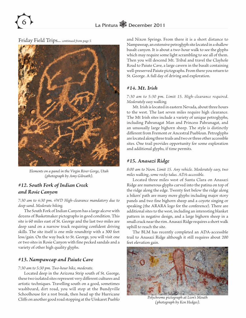
Elements on a panel in the Virgin River Gorge, Utah (photograph by Amy Gilreath).
Polychrome pictograph at Lion’s Mouth (photograph by Ken Hedges).
#12. South Fork of Indian Creek and Rosie Canyon 7:30 am to 4:30 pm. 4WD High-clearance mandatory due to deep sand. Moderate hiking.
The South Fork of Indian Canyon has a large alcove with dozens of Basketmaker pictographs in good condition. This site is 60 miles east of St. George and the last two miles are deep sand on a narrow track requiring confident driving skills. The site itself is one mile roundtrip with a 300 feet loss/gain. On the way back to St. George, you will visit one or two sites in Rosie Canyon with fine pecked sandals and a variety of other high quality glyphs.
#13. Nampaweap and Paiute Cave 7:30 am to 5:30 pm. Two-hour hike, moderate.
Located deep in the Arizona Strip south of St. George, these two isolated sites represent very different cultures and artistic techniques. Travelling south on a good, sometimes washboard, dirt road, you will stop at the Bundyville Schoolhouse for a rest break, then head up the Hurricane Cliffs on another good road stopping at the Uinkaret Pueblo
and Nixon Springs. From there it is a short distance to Nampaweap, an extensive petroglyph site located in a shallow basalt canyon. It is about a two-hour walk to see the glyphs which may require some light scrambling to see all of them. Then you will descend Mt. Tribal and travel the Clayhole Road to Paiute Cave, a large cavern in the basalt containing well-preserved Paiute pictographs. From there you return to St. George. A full day of driving and exploration.
#14. Mt. Irish 7:30 am to 5:30 pm. Limit 15. High-clearance required. Moderately easy walking.
Mt. Irish is located in eastern Nevada, about three hours to the west. The last seven miles require high clearance. The Mt Irish sites include a variety of unique petroglyphs, including Pahranagat Man and Princess Pahranagat, and an unusually large bighorn sheep. The style is distinctly different from Fremont or Ancestral Puebloan. Petroglyphs are located along three trails and two or three other accessible sites. One trail provides opportunity for some exploration and additional glyphs, if time permits.
#15. Anasazi Ridge 8:00 am to Noon. Limit 15. Any vehicle. Moderately easy, two miles walking, some rocky talus. ADA-accessible.
Located three miles west of Santa Clara on Anasazi Ridge are numerous glyphs carved into the patina on top of the ridge along the edge. Twenty feet below the ridge along a hikers’ path are many more glyphs including major story panels and two fine bighorn sheep and a coyote singing or speaking (the ARARA logo for the conference). There are additional sites to the west, including an interesting blanket pattern in negative design, and a large bighorn sheep in a small crack near the rim. Anasazi Ridge requires a short walk uphill to reach the site.
The BLM has recently completed an ADA-accessible trail to Anasazi Ridge although it still requires about 200 feet elevation gain.
Friday Field Trips... continued from page 5

7December 2011La Pintura
#16. Santa Clara and Anasazi Ridge 7:30 am to 4:00 pm. Limit 15.
See #1 above for trip description.
#17. Zion National Park and Quail Creek 7:30 am to 4:00 pm. Limit 12.
See #2 above for trip description.
#18. Gunlock Reservoir and Nearby Sites 7:30 am to 4:00 pm. Limit 15.
See #3 above for trip description.
#19. Fort Pierce Wash 7:30 am to 4:00 pm. Limit 15
See #4 above for trip description.
#20. Red Cliffs, Babylon, and Quail Creek 7:30 am to 4:00 pm. Limit 15. High-clearance vehicle required. Moderate hiking.
The Red Cliffs site is not far from an Ancestral Puebloan village site that has been excavated. There is a panel of petroglyphs on an east-facing ridge that may have solar interactions. After visiting this site, you will travel to Babylon, with its walking quail or anthropomorphs with burden baskets (your choice) and another site on a boulder nearby. You will end at the Quail Creek site near the Virgin River with its large archaic panel, large Ancestral Puebloan story panel, and numerous petroglyphs on boulders and slickrock. Babylon and Quail Creek are mostly drive-up sites. Red Cliffs involves a one mile cross-country walk and a short climb.
#21. Canaan Gap, Yellow Man, Cave Valley7:30 am to 4:00 pm. Limit 12. Moderate hike.
Located 35 miles east of St. George near the villages of Little Creek Mesa is a series of rock art sites. Canaan Gap has a very large panel and several smaller panels of deeply incised petroglyphs, including dozens of anthropomorphs. A few miles north is Yellow Man, a large pictograph with an ornately painted headdress. We will travel north along the Smithsonian Butte Scenic Byway to Cave Valley in Zion
National Park where you will see the site type for Cave Valley style rock art, wonderfully triangulate anthropomorphs. In a smoke-lined cave are many figures painted in diverse colors and often superimposed. Of particular interest are the flute players near the ear of the largest anthropomorph. Canaan Gap and Yellow Man involve about 50 feet of climbing, and Cave Valley requires a walk of about one mile in sandy soil. About 120 miles of driving.
#22. Virgin River Gorge, Little Black Mountain, and the Bear Site 7:30 am to 3:00 pm. Limit 15. High-clearance recommended. Moderately strenuous due to the Virgin River Gorge hike; other two are drive-up with easy walking.
These three sites are located with a 20-mile radius of St. George, and have in common a totemic quality. There are four sites in the Gorge, including the glyph sometimes referred to as DaVinci Man, a large boulder with hunting scenes, and a remarkably well done petroglyph of a heron diving toward the nearby Virgin River. To the southeast of St. George is Little Black Mountain with dozens of panels on boulders, including a very large story panel with a heron drinking water from a depression that fills with rain water—a perfect counterpoint to the diving heron in the Virgin River Gorge? Close by is the Bear Site, with its dramatic stone image of a charging bear and pecked bear paws. The Virgin River
St. George Field Trips, ARARA 2012Monday, May 28, 2012
An abstract element from one of many panels at Black Point, near Cedar City, Utah (photograph by Amy Gilreath).
...continued on next page

8 La Pintura December 2011
Gorge sites involve descending (and ascending) 150 feet on a rocky trail, two miles total hiking. Little Black Mountain is a walk-up site with smooth, wide trails; and the Bear Site is a drive-up site with a very short walk.
#23. Rosie Slots and Rosie Canyon Petroglyphs 7:30 am to 4:00 pm. Limit 15.
The Rosie Slots are located north and east of St. George, and are narrow slot canyons with unusual petroglyphs, a fine hidden site. Rosie Canyon has many petroglyph and village sites. The one you will be visiting has multiple, large pecked sandals and other high quality glyphs.
#24. Lion’s Mouth, Black Point, and Parowan Gap 7:30 am to 3:00 pm. Limit 15. High-clearance recommended. Moderate hiking at the first two; third is a drive-up.
These sites are north and west of Cedar City. Lion’s Mouth is a cave with exceptional Paiute pictographs. Black Point has high quality Fremont petroglyphs including unusual anthropomorphs and a sky panel facing east. Lion’s Mouth requires a walk of less than one mile up a small hill on a gentle trail. Black Point requires a 150 foot climb up a moderately steep slope with some rocks to negotiate along the talus slope. Parowan Gap is a drive-up site. About 180 miles driving, mostly on paved roads. Black Point has the only section that may require high clearance.
#25. Parowan Gap to Black Point Loop 7:30 am to 4:00 pm. Limit 15.
See #10 above for trip description.
#26. Kirk’s Grotto and Babe’s Butte 7:00 am to 3:00 pm. Limit 12 people and three vehicles at the trailhead by BLM regulation. High-clearance required. Moderate hike.
These sites are located about 1 ½ hours south of St. George in an area of eroded red slickrock. You will visit Kirk’s Grotto and Babe’s Butte, both of which have extensive petroglyphs that are Ancestral Puebloan. Kirk’s Grotto is in a shaded slot canyon with petroglyphs inside and outside the slot, including an interesting upside-down plant or tree of life. Babe’s Butte is a sandstone spire with rock art almost completely around the base, including a Venus symbol. Babe’s
Butte requires a short walk along a closed road. Kirk’s Grotto requires a 100 foot descent down a moderately steep hill on an old road.
#27. Nampaweap and Paiute Cave 7:30 am to 5:30 pm. Limit 15.
See #13 for trip description.
#28. Snake Gulch 7:00 am to 7:00 pm. Limit 15. Strenuous. High-clearance recommended. 10-mile roundtrip hike easy except for its length.
Located east of St. George approximately two hours away, Snake Gulch is a gentle, shallow canyon that originates along the base of the Kaibab Plateau. It also has the most spectacular Fremont pictographs in the area, many individuals and family groups decked out in polychrome finery. Pictographs stretch out on canyon walls for at least two miles. 240 miles driving.
#29. White River Narrows 7:30 am to 6:30 pm. Limit 15. High-clearance recommended. Easy hike, drive-ups with short walk.
This group of sites in eastern Nevada has seven individual locations where there are archaic, Ancestral Puebloan, and Shoshone petroglyphs located along the wall of an old river channel. The sites vary in size: some solitary (and intriguing) like “Shoshone Frog,” others with large complex panels with a variety of symbols, some perhaps calendrical. Access to the sites is by a short unpaved spur off of paved roads. 240 miles driving.
#30. Quail Creek and Cave Valley 8:00 am to 1:00 pm. Limit 12. Any vehicle. Moderately easy hike and drive-ups.
The first stop will be the archaic and Ancestral Puebloan petroglyphs at Quail Creek. Later you will go to Zion National Park’s Cave Valley where you will see the site type for Cave Valley Style rock art. In a smoke-lined cave, you will see archaic and Paiute pictographs in a variety of colors and superimposed. The major panels at Quail Creek are drive-up sites although there are many glyphs on slickrock and boulders above the road which are moderately easy to see. Cave Valley requires a one-mile roundtrip walk on sandy soil. 100 miles driving.
Monday Field Trips... continued from page 7

9December 2011La Pintura
Virgin River Gorge, Utah
(photograph by Amy Gilreath).
Parowan Gap (photograph by Ken Hedges).

10 La Pintura December 2011
The IFRAO 2013 planning committee met in August to work on field trips, the program, and general
organizational items. For those of you who have not been to an international conference before, one of the interesting offerings at these venues are companions trips, which are day excursions for those attending the meeting with their rock art aficionado spouse or friend who want to spend their day learning about something other than rock art. Albuquerque is a multicultural town, and companions will have several opportunities to learn about the Southwest during the conference. For example, a visit to the Hispanic Cultural center that houses the Disney Performing Arts Theaters was overwhelming. There are many theaters and performing arts companies presenting productions in Albuquerque. There will be a list available at the conference. Supporting organizations for the conference —Petroglyph National Monument and the Indian Pueblo Cultural Center (IPCC)—met with the committee. Both will be open before, during, and after the conference for attendees to visit as well as companions.
We have a dynamic Field Trip Committee with a strong knowledge of the area and genuine excitement about sharing those sites with a broad-based audience. New Mexico has a long history in both written media and in images left on the stone. The biggest challenge is trips have to be limited to one day, and the committee is cognizant of not over-visiting any one site on that day. The conference-sponsored field trips will be on Wednesday, May 29, 2013, in the middle of the conference. Of course, there will be pre- and post-conference trips handled by local destination management tour companies. Watch for further announcements as the conference gets closer.
The program is shaping up, too. The Call for Sessions went out in January. If you are interested in organizing a session check the arara.org web site under IFRAO for the requirements, then contact Mavis Greer with your session proposal. A number of sessions have already been proposed, and will soon be posted to the web site. In addition to organized thematic sessions, there is also room for individual papers on the topic of your choice. That call will formally be issued at the end of the year, but if you have an idea you would like to submit, please email your abstract to [email protected] at your earliest convenience. As this is an international conference, the committee has invited a
number of public speakers to educate the interested public and the attendees.
One of the delightful projects the planning committee engages in is to research eating establishments in the area of the venue. There is a shopping mall across the highway with many chain restaurants. The real treat is a strip mall one block away from the Marriott conference hotel with three coffee shops, four local restaurants including an Italian trattoria, a FedEx for shipping, and even a beauty shop. There are a number of fast-food places within six blocks. There is a shuttle to the Sandia Casino from the conference hotel that will transport guests to the six restaurants there.
We are working hard to make the conference one to look forward to, as well as one that leaves great memories for all attendees.
Teddy Lou Stickney Honored
As indications of our community’s deep appreciation for Teddy Stickney’s efforts in education, public outreach,
and preservation of rock art, she has recently received two awards. The Shumla School, located between the Lower Pecos River and the Rio Grande in Texas, is creating a scholarship fund in her name. And, at this year’s Texas Historical Commissions Annual Historic Preservation Conference, she was presented with the prestigous Curtis D. Tunnell Lifetime Achievement Award in Archeology. To see Teddy Lou in action and hear tributes offered by her colleagues, view the wonderful video that THC featured at their awards banquet: http://www.thc.state.tx.us/awards/awdwin11.shtml
ARARA has greatly benefited from Teddy Lou’s support and involvement. She was elected and first served on our Board in 1995, and most recently served as our President in 2002-2003.
Teddy in Puerto Rico at the 2006 Society for American Archaeology conference (photograph by John Greer).

11December 2011La Pintura
Rock Art Bookshelf
Discovering South Carolina’s Rock Art
Tommy CharlesColumbia: University of South Carolina Press, 2010.168 pp., 18 color and 101 b/w illustrations, $29.95 (cloth)
Reviewed by Gretchen Monroe
Rock art is almost taken for granted in the American Southwest. It adorns river beds, caves, shelters, and rock
outcroppings, occurs along ancient trails, has been the subject of study and cataloging, and is the focus of ARARA.
Rock art in the Southeast is not as extensive, and here rock art sites are more elusive because of the nature of the climate, structure of geological formations, types of rock, and extensive modern development. Like those who once maintained that there is little rock art in the Northern Rio Grande Valley, there have been many who doubted that prehistoric rock art exists in South Carolina. At last they are proven wrong by Tommy Charles’s book.
According to Charles, interest in South Carolina rock art began “unofficially and unintentionally in 1983 when a collector of Indian artifacts reported a petroglyph located in the Blue Ridge Mountains of Oconee County.” It was not until January 1997 that the University of South Carolina Institute of Archaeology and Anthropology (SCIAA) began an official survey to find and record rock art sites in the state. This book is Charles’s story of that journey of discovery, one that begins to fill in a missing chapter in the story of the state’s prehistoric and historic past.
Highly readable, extensively researched, and supported with photographs and charts, Charles’s book is hard to put down. A modest man, he gives full credit not only to the help of his researchers and survey participants, but also to the general public since it is their information that primarily allowed him to make up for the lack of a preexisting study of South Carolina’s rock art. He discusses the difficulty of obtaining good quality images of panels prior to digital photography, and acknowledges how modern tools, like Photoshop and other programs, help acquire interpretable pictures of ancient rock art. Other interesting aspects of his book are the coverage he provides of historic art, and the accurate locations and time periods he provides for the sites.
Charles’s book reminds the reader of how fragile rock art panels are, subject not only to the ravages of weather but also to the destructive impacts we are having on them. He
Rock Art Bookshelf
El Arte Indígena de CoahuilaSolveig Turpin Saltillo: Universidad Autónoma de Coahuila, 2010. Available in the U.S. in very limited supply through Whole Earth Provision Co., 1010 West 11th Street, Austin, Texas 78703 (512-476-1555). 226 pp., parallel text in English and Spanish, 153 color plates and illustrations, $35.00 (soft cover)
Reviewed by William B. Murray
With the publication of Solveig Turpin’s new book on the rock art of Coahuila, a large blank spot on
the North American rock art map just south of the Texas border begins to come into view. Her book represents the first attempt to fit Coahuila’s abundant (300+) rock art sites into the larger continental picture and shed some light on this strategic area astride the east edge of the Chihuahuan Desert of North America.
The book is written in a very readable style and published in an amply illustrated bilingual (Spanish/English parallel text) edition by the Universidad Autónoma de Coahuila. In it, Turpin summarizes the findings of almost 20 years of archaeological explorations and projects in both Coahuila and Nuevo León. Her extensive field work in south and west Texas provides a broader view that reconnects the two sides of the border zone and thereby offers a new and more integral perspective on regional prehistory.
At the center of her account is the conclusive identification of Pecos-style paintings in the high mountain caves of northern Coahuila. Turpin’s documentation of these sites is presented here for the first time in full color illustrations and considerable detail. They broaden the range of this unique early painted tradition, which many ARARAns got to see during the recent annual conference in Del Rio, Texas. Turpin also relates the Pecos tradition stylistically to other ones on the Mexican side, such as the Chiquihuitillos painted style which she identified in northern Nuevo León, as well as the petroglyphs of the La Presa style further south near Saltillo (Coahuila), and to a lesser degree the polychrome rock art further to the west in Chihuahua.
Her discussion of indigenous art is not just limited to rock art either. She views other artistic/symbolic manifestations as complementary data. They include painted deer scapulae, carved bone scarifiers found in northern Coahuila and apparently used in blood-letting rituals, and particularly the incised pebbles first discovered in northeast Mexico at Boca de Potrerillos (Nuevo León) and later in a much larger sample at El Pelillal (Coahuila). These are a parallel type of artifact
...continued on next page ...continued on next page

12 La Pintura December 2011
to the well-documented painted pebbles from south Texas. Although their use is still not conclusively determined, the Mexican artifacts display at least three distinct styles, and Turpin speculates on their possible use as fertility amulets.
Nor does indigenous rock art cease with the arrival of the white man. Turpin’s chapter on the rich trove of Coahuila rock art from the colonial period is especially strong, and makes good use of historic accounts to place both Spanish inscriptions and Native American manifestations in context. The rugged mountains in central Coahuila became the last redoubt of the Native American resistance to Spanish incursions. Rock art provides the only Native view of this confrontation, documenting both their curiosity for the new things brought by the Spaniards (built structures like the missions and horses) and the ensuing conflict (headless Spanish horsemen) which led to their decimation and disappearance by the end of the eighteenth century, only to be replaced in the nineteenth century by Apache and Comanche raiders. In this later phase, the modern border doesn’t really exist. Coahuila and Texas formed a single political unit and shared a common history up to the time of the Mexican-American War.
This work also represents Turpin’s most complete exposition of a shamanic explanation of the Pecos rock art, a topic which she has developed in various earlier publications. A shamanic context for this tradition was first advanced in the 1960s, but Turpin updates it by applying the current ASC model formulated by David Lewis-Williams, in order to identify features indicative of altered states of consciousness in the Pecos-style panels of northern Coahuila. Whether one agrees with this interpretation or not, Turpin presents the key evidence here and argues the case as she sees it in full detail.
She also explores the shamanic explanation for the rock art further south in Coahuila and Nuevo León, where both similarities and differences can be noted. There are no Pecos-style anthropomorphs here, and both the media and site context change. Although they are rare in south Texas, petroglyphs are by far the most common form of rock art
in northeastern Mexico. The sites vary greatly in size, but some of them are very extensive, and located on the exposed rocky ridges which afford a dominant view of the semi-desert landscape. This is a very different setting from the more confined and intimate river shelters of the Pecos Tradition. At many sites, different rock art traditions are present and sometimes even superimposed, but their chronology remains vague, although probably very long. All these differences make comparisons more difficult.
With regard to the shamanic interpretation, there are no direct ethnohistoric accounts linking Amerindian rock art production to altered states of consciousness, but the ritual use of peyote is well documented in colonial sources. The plant was relatively abundant in this area until recently, and often found in association with rock art sites. It continues to be a sacred plant even today for the Rarámuri of southern Chihuahua and the Huichol of Jalisco/Nayarit. Debate centers not so much on the antiquity of peyote use, but whether it has any specific relevance for interpreting the rock art iconography. Turpin points out numerous features of it which illustrate Lewis-Williams’s postulates.
Turpin’s work is obviously not the last word on the rock art of Coahuila, which still remains understudied and even undocumented in some cases, but it is certainly an auspicious beginning, and its limitations do not undermine its positive contributions. While her knowledge of transborder connections is comprehensive, Turpin is much less concerned with connections to rock art in other parts of Mexico, especially its possible relation to the cultural expressions further south in the Mesoamerican high civilizations. For example, while the La Presa style is discussed extensively, no mention is made of the seven-month lunar tally at its type site which includes notations of the lunar eclipse cycles recorded in the Dresden Codex. It seems as if the Mesoamerican frontier may be a more formidable barrier than the current international border, and we must wait for more in-depth rock art studies by Mexican researchers to breach this gap.
recounts disappointments of attempting to relocate rock art and other sites only to find that they have been bulldozed for residential or commercial purposes. These accounts remind us that preservation is becoming an increasingly important aspect of maintaining heritage sites for the public
trust. Charles’s book, Discovering South Carolina’s Rock Art, leaves the reader with the enjoyment of a very readable and professional presentation of South Carolina’s rock art, one that fills a gap in the discussion of rock art in North America.
South Carolina’s Rock Art... continued from page 11
El Arte Indígena de Coahuila... continued from page 11
13December 2011La Pintura
The Editor’s Corner
What’s New?
One of the best parts of archaeology is that there are always new discoveries. Archaeology explores new frontiers and
does make news, sometimes inflated, by encountering things that fill in the picture of the past in surprising ways.
This came home to me recently when I had the opportunity to attend the 16th Román Piña Chan Symposium at the National Museum of Anthropology in Mexico City. The event—originally initiated by his former students—is a posthumous honor to one of the eminences of Mexican archaeology, and features exclusively invited talks on topics of current archaeological interest. This year’s special theme was “Mexico-Brazil: Archaeology in Development.” The poster advertising the meeting showed rock paintings from the Sierra de Capivara, so I was hooked.
Unfortunately, only two Brazilians participated, but their contributions were of exceptional value. Dr. Tania Andrade Lima of the National Museum at the Federal University of Río de Janeiro gave a broad historical review of Brazilian archaeological studies, including a recent emphasis on historical archaeology which documents how the capitalist world system impacted on the Native population.
The other Brazilian participant, Dr. Gisele Daltini Felice of the Museum of American Man Foundation, spoke about the Sierra de Capivara in relation to the question of human antiquity in the Americas. This is a special problem which is inescapable for Brazilian archaeologists, and her talk was the keynote for a broader panel on the Early Man question which presented recent Mexican studies on the same topic.
Dr. Daltini refrained from categorical statements and simply showed a listing of the early dates from Brazil obtained so far, but her presentation emphasized at least two main points which are frequently overlooked in this often passionate debate. First, although the Pedro Furada site has received the most attention and publicity, there are in fact many other rock art sites in the same region, some of which have very thorough archaeological documentation. The Brazilian interior is one of those open frontiers of rock art studies, and more sites are being discovered all the time. Second, although the early dates (40,000-35,000 B.P.) are few, there are many more dates from the period of 20,000-12,000 B.P. deriving from a variety of sites, all of which fit comfortably with the early dates now available from other parts of South America. The challenge arises because all of them are earlier than those from North America where the earliest horizon is still post-glacial.
If earlier evidence is to be found, it would more likely come from areas further to the south unaffected by the glacial ice sheet. Here the Mexican participants filled-in some blank spaces with new data from Baja California, Sonora, and Chihuahua, as well as subaquatic data from Quintana Roo on the Maya coast. In Mayaland coastal sites occupied earlier were flooded by rising post-glacial sea levels, creating extraordinary preservation conditions for both human bones and artifacts. The data from these sites were presented by Alejandro Terrazas of the National University of Mexico, and go back to 13,600 B.P.
For Baja California, Harumi Fujita presented occupations associated with shell mounds dated to 11,000-10,300 B.P., indicating an early use of the coastal route. But in the rest of the region, due to erosional processes, most early lithic artifacts are found on the surface and cannot be conclusively dated. This is particularly the case in Chihuahua, where Rafael Cruz found many records of Clovis and other early point types, but none associated with stratified deposits.
This made the recently discovered site of Fin del Mundo, Sonora (yes, the town’s name does mean End of the World!), such a special case. It is located on the flat plains just south of Hermosillo, Sonora, and preserves some stratified terraces whose layers are dated from 11,000-10,000 B.P. Their remains include late glacial megafauna, including the smallest of the New World elephants, and at one location eight to ten Clovis points made from a local source. While the association is not direct, it is indeed close, and work on the site continues with American collaborators from the University of Arizona and INAH’s Sonora regional office forming part of the team. The Fin del Mundo site is another archaeological frontier still opening up.
Other Mexican presenters brought new discoveries unrelated to early man, but equally surprising. For example, the discovery of an extensive tunnel under the Quetzalcoatl temple adjoining the Ciudadela in Teotihuacan is adding an exciting new dimension to that key site. The director of the Tlalocan project, Sergio Gómez Chávez, gave an update on the laser scanning and excavation of this feature, which involves removing cultural debris used to close it sometime in the 2nd-3rd centuries A.D. According to the laser images, a large empty chamber lies ahead under the center of the structure, and the drama mounts as the excavators approach this tantalizing objective.
The tunnel served as drainage from the huge enclosed plaza of the Ciudadela, which Gómez speculated was designed to be inundated in order to recreate a ritual setting simulating the emergence of the present world from the primordial waters. Whether that is true or not, it would certainly have been quite a spectacle!
...continued on next page

14 La Pintura December 2011
Conservation Report
Vandals Guilty—Idaho Rock Art Site, Restoration PendingBy Julie Altman
On January 6, 2010, I visited Red Elk Rockshelter, a Nez Perce pictograph site a few miles south of Lewiston,
Idaho, along the Snake River by Hell’s Gate State Park. I am a master’s student in Anthropology at the University of Idaho in Moscow, Idaho, and I was in the beginning stages of writing a thesis about rock art. My major professor, Lee Sappington, suggested that I visit Red Elk Rockshelter in order to familiarize myself with Columbia Plateau rock art. I photographed the site extensively, impressed by the beauty of the spectacular volcanic basalt formations and location along the river.
The following month I was shocked to learn that the rockshelter had been severely vandalized. Nearly all of the pictographs had been covered by spray paint with marijuana references. Since I was the last person known to have documented the site before the vandalism, I turned my photos over to the U.S. Army Corps of Engineers.
Three young men were implicated in the vandalism and charged under the Archaeological Resources Protection Act of 1979. Two chose to plead guilty and the other maintained his innocence. On October 4 of this year, the federal case went to trial. I was called as a witness and asked to testify about the pictures I had taken. During the trial my photographs were displayed on a large screen, and I explained what was visible in each. I testified that the site had been in pristine condition prior to the vandalism, with only a few small scratched initials alongside the pictographs. The defense claimed that there were over 80 graffiti marks already at the site, and that the
site was in such poor condition that the vandals thought nothing of adding a little more graffiti to the mix. However, I and other witnesses who had viewed the site prior to the vandalism disagreed.
Two days later, I was happy to learn that the young man on trial was found guilty. All three men involved in the vandalism will be sentenced in January 2012. Restoration of the rock art will be undertaken at an estimated cost of $150,000. Hopefully this well-publicized case will serve as an example of why not to vandalize rock art sites. This incident illustrates the importance of our interest in rock art and the potential value of the photographs that we take.
Red Elk Rockshelter pictographs, January 2010, before vandalism. Red Elk Rockshelter Pictographs, after vandalism.
...continued on page 17
Equally surprising has been the discovery and exploration of the large site at Cantona, Puebla, presented by Katrina Vackimes, which may have been Teotihuacan’s successor as the prime Mesoamerican trade center. Only 1% of the site has been excavated so far, but its size (14 km2) and layout are definitely urban and its estimated population maximum is 90,000 inhabitants, dedicated mainly to trade and craft production. Petroglyphs are scattered around the site, some of them associated with the more than 20 ball courts which are one of its most exceptional features.
Further south, Lourdes Budar of the Universidad Veracruzana has been exploring earlier Olmec ball courts at Piedra Labrada, Veracruz. These are made of mounded earth
What’s New... continued from page 13

15December 2011La Pintura
San Diego Museum of Man’s 36th Annual SymposiumBy Sherry Eberwein & Elanie Moore
This year’s day-long event was held on November 5 at the San Diego Zoo’s Otto Center in Balboa Park. The
symposium logo featured a Maricopa shield design adapted from a petroglyph in Red Rock Canyon in the lower Gila River region of southwestern Arizona. This logo was used on the programs, commemorative ceramic mugs, and t-shirts that were available. The papers presented results of rock art research from around the world in illustrated lectures divided into four sessions.
Ken Hedges opened the meeting with a moment of reflection in memory of Cahuilla elder Katherine Siva Saubel, who passed away on November 1 at the age of 90. Dr. Saubel was a Native American scholar, historian, linguist, co-founder of the Malki Museum, and author or coauthor of numerous books and articles on her culture. She was one of California’s most respected tribal elders and her enduring commitment to the cultural and spiritual beliefs of Native Americans will be missed. Her remembrance was accompanied by photos of her at the important ringing rock petroglyph sites in Menifee Valley and Zion Wash.
The first two papers in the opening session were given by noted researchers from California.
A preliminary report on Saline Valley (California) was given by Don Christensen. Saline Valley occupies an interior-drained basin between Owens Valley and Death Valley. A major habitation site with a variety of archaeological features is being documented, including rock art, milling features, an artifact scatter, a historic arrastra, cobble mounds, and rock cairns. The ritualistic and domestic activities at this site are still under study.
Steve Freers of Murrieta, California, gave what was the most disturbing of all presentations for the day. His research on “The Wildfire is Over, Now Cross your Fingers: The Impact of Chemical Fire Suppression Agents on Rock Art,” dealt with the impact of a 200-acre fire last August in southern California near pictograph shelters. New chemical fire retardants used to fight California’s annual wildfires have the potential for damaging pictographs. Although there seems to have been no damage to them during recent wildfires, there is concern that incremental runoff of soluble chemicals during rainfall may still do damage. Steve used Jon Harman’s DStretch to photograph the fire retardant, and local land managers, Native American specialists, archaeologists, the Fire Chief, and manufacturers of the retardant material were consulted before conservation efforts to remove the retardant material from the boulder surfaces
near the pictographs were implemented.Care was taken to protect the rock art sites while removal
of the retardant was done. His conclusions are incomplete, and he will be following up in the future.
Ron Barber from Los Alamos, New Mexico, closed the first morning session with a paper on “Stone Calendars of the Southwest.” He has been studying calendars with specific glyphs that align with unique shadows to mark times of the year, including winter and summer solstices, equinoxes, and cross-quarters, as well as other dates. The Stone Calendar Research Project is attempting to identify the western regional extent of this type of calendar technology. He treated the audience to a fascinating DVD from 4 years in the field, compiling time-lapse photography of many solstice, equinox, and cross-quarter solar interactive events from across the Southwest to Washington’s Columbia River and Mexico’s Sierra Madre. We watched shadows move across what Barber called prehistoric “stone calendars.” One after another they were uniquely different in their imagery but very accurate in marking the solar event.
The second session included three papers from Baja California Sur, Mexico, that complemented each other: “Los Pozos: A Nostalgic Look at a Petroglyph Site in Baja California Sur,” by François Gohier, laid the geographical groundwork for all three papers. He showed maps of the Baja California peninsula where ancient trails ran along the Pacific Coast to the Sea of Cortez, and compared slides he made on visits to the Rancho Carricitos petroglyph site near the village of San Ignacio in 1982, 1983, and 2000, where more than 2,000 petroglyphs are pecked into andesite boulders. He ended his presentation with photos from the nearby Great Mural pictograph sites, pointing out several images that may relate to similar ones among the petroglyphs.
François’s presentation led right into Elaine Moore’s paper “At Cueva Pintada, the Proof is in the Pole,” which presented recent evidence demonstrating that long poles of cardon ribs and carrizo cane could be used to produce Great Mural paintings that occur as high as 45 feet above the shelter floors in the Sierra de San Francisco. Surface pressure keeps the lightweight pole from bouncing off the cave surface so there would be no sway as paint is applied. Further experiments are planned to determine if the ends of the cane can be prepared to hold paint and release it by capillary action onto the rock through surface pressure between the cave wall and the tip of the pole.
In “Creation Emergence Mythology: The Great Mural
...continued on next page

16 La Pintura December 2011
Site of Cueva Pintada, Baja California Sur, Mexico,” Eve Ewing gave an appropriate interpretation of what appears to be a symbolic birthing chamber in a small cave below the most famous mural at Cueva Pintada, also in the Sierra de San Francisco. Ewing seamlessly tied together the natural surface and its undulations and cracks, the pictographs upon it, a natural yoni formation in the cave, and a perennial water seep in an interpretation that suggests power and life force can be regenerated on an annual basis through re-enactment of their Creation Mythology.
She concluded that the chamber has a correlation with the ethnographic records for Native Baja Californians regarding their creation mythology about receiving power and life force.
John Rafter made a poignantly thorough study of 30-foot high Phallic Rock, a natural formation near Aguanga in the Luiseño territory of southern California. By applying DStretch, he could see about 85% more pictographic imagery on boulders near and around the prominent rock formation. A vulva-shaped rock shelter was also found nearby. A phallic-shaped beam of light penetrates the concave shelter, reaching furthest back on the summer solstice during what is” spring” to us, regarded as the beginning of the new year to the Luiseño. A natural bulge in the shelter wall marks the equinox between summer and winter solstices. Other painted and engraved images appear related to Phallic Rock and the female cave. Rafter believes the various elements combine to illustrate the Luiseño creation myth of the sky impregnating the earth as was revealed in detail by their elders around 1908.
The first afternoon session had four thought-provoking papers. “About our Logo: Late Period Rock Art on the Lower Gila” was presented by Ken Hedges. The Maricopa shield motif is found in the lower Gila River region of southwestern Arizona where Ken has been researching rock art for many decades. He noted that from Gillespie Dam downstream, identifiable Patayan rock art elements continue into the historic period, but that the latest Patayan rock art is idiosyncratic and cannot be assigned to specific or defined styles. He shared an overview of the most recent studies distinguishing between two major rock art sites, focusing on Red Rock Canyon where the logo design is found.
“Contact Period Indigenous Inscriptive Art at Mission San Diego and the Presidio San Diego” by Richard L. Carrico, a historian from San Diego State University, was unique. His research was about baked roof tiles and paving stones that were recovered from early missions in both Alta and Baja California. His interest began during an excavation that started at the San Diego Mission and the Presidio San Diego in 1989.
Incised inscriptions were made in wet adobe clay with fingers, sharp tools, and even punctuated possibly with an awl, and their images hardened into permanency when the tiles and paving stones were fired. The array of imagery on the tiles at the mission on Presidio Hill (A.D. 1774 to 1889) are consistent with those similar images found on Kumeyaay Tizon Brown Ware and their rock art. Carrico suggests they had simply moved from one technology, stone, to another, adobe clay. The cultural meanings probably remained the same
Greg Erickson’s paper, “New Insight into Old Rock Art,” reported the results of a four-year investigation of a major Rancho Bernardo Style rock art site in the heart of Rancho Bernardo. By using DStretch, Greg was able to discover new pictographs, including a unique anthropomorphic figure with cloven hoof-like feet. In the course of documenting the site, he found six cupule boulders and carved motifs. He concluded that some cupules show alignments toward other sites.
The final paper of this session was “Rock Art and Prehistoric Populations of the El Paso Range, Eastern Kern County, California,” by Alexander K. Rogers of the Maturango Museum in Ridgecrest, California. The El Paso Mountains were the home of the ethnographic Desert Kawaiisu, and represent a linguistic and geographic border. The rock art in this area shows affinities with the Coso region and the Mojave Desert. Alexander presented the typical rock art of the region and the chronology from early Archaic, ca. 10,000 B.P., to the Northern Uto-Aztecan speakers.
The final afternoon session had the participants travel from New Mexico to England, and then ended the adventurous day in Western Canada. “Report on Results of Rock Art Recording at Cottonwood, New Mexico” was presented by Margaret (Marglyph) Berrier. The Cottonwood Site is located north of Las Cruces on the Jornada Experimental Range. Because people are allowed into this site only with special permission, the rock art has been well preserved. She presented information on recording methods, distribution, dating, and possible cultural affiliations, as well as comparisons between the Archaic and Jornada Mogollon rock art styles that are found at Cottonwood and in the surrounding areas.
In “Stonehenge Rock Art and Soundscape,” Steven J. Waller continued his research on acoustics and rock art around the world, and provided the audience with his observations of rock art carvings of axes on several megaliths at Stonehenge. In European mythology the ax represents thunder, and Steve wanted to test for thunderous reverberations there. During his presentation he played a recording of echoes from Stonehenge on “E-stretch,” which slowed down the echo to make it easier to hear. The evidence that he presented by using these sound echoes and auditory illusion with blindfolded volunteers demonstrated that dead zones of sound wave cancellation
Symposium... continued from page 15
...continued on next page

17December 2011La Pintura
IFRAO June 2012: Bolivia
There is still time to get your passport and make travel plans to attend the upcoming International Federation
of Rock Art Organizations (IFRAO) annual congress this coming summer. The meetings are being held in La Paz. The program and session abstracts are now provided at the website dedicate to this event: www.siarbcongress.org. The meetings will include a tribute to Dr. Juan Schobinger (1928-2000) for his pioneering work with the archaeological record of Argentina and the Andes. Should you have any questions, the event organizer is Matthias Strecker who may be contacted at [email protected] or SIARB, Casilla 3091, La Paz, Bolivia.
Excursions that are being offered before and after the congress include the following:
Tours to the archaeological and rock art sites of Titicaca •LakeOne-day excursion to Tiwanaku•Special La Paz city tour•City of Potosi and Betanzos rock art sites•City of Sucre and rock art of Incamachay-Pumamachay•Rock art sites in western Santa Cruz department (2-day tour •from the city of Santa Cruz): Mataral and Paja ColoradoSculptured rock of Samaipata, World Heritage site (1-day •excursion from Santa Cruz)Archaeological and rock art sites of Tarija, south Bolivia.•
These tours are exclusively arranged for congress participants. More detailed information will be provided on the dedicated website for the event.
ForumIs It or Isn’t It?
A recent article by Ekkehart Malotki and Henry Wallace argues that the petroglyph shown below from the Sand
Creek site near Bluff, Utah, illustrates a mammoth. If confirmed, it would be the first example of a
mammoth representation in North American rock art, and a powerful indicator for the relative antiquity of at least some rock art representations. Malotki and Wallace’s arguments for this interpretation are available in Rock Art Research Vol. 28(2):143-152, available online at: http://www.bradshawfoundation.com/pdf/Malotki_Wallace_RAR_mammoths_paper.pdf. But the identification is still controversial…What do you think? Is it or isn’t it a mammoth? Send your considered opinion (pro or con) to the Editor, La Pintura: [email protected]. Responses will be published in a future edition of this journal.
Sand Island, Utah, petroglyph (photograph by Henry D. Wallace), from Rock Art Research 2011 28(2):147.
and are sometimes associated with rock art. Her colleague, Lourdes Hernández Jiménez, showed rock paintings from the Cueva Uxpanapa in the adjoining Chiapas highlands which included a pictographic inscription in an early form of Zapotec writing. These explorations point further back in time, and begin to document rock art’s relation to early forms of writing, a field still to be explored when an adequate interdisciplinary database can be assembled.
Overall, rock art was only a tangential part of the Piña Chan symposium, but it pointed out new challenges for rock art researchers. Dating and chronological control may still be lacking, but relationships become more obvious once all the pieces are on the table. In order to fill in the gaps in the prehistoric picture, we need to get the broadest view possible of the whole field—an opportunity which can be realized at our upcoming international meeting in Albuquerque 2013.
What’s New... continued from page 14
Symposium.. continued from page 16
inspired the design of Stonehenge.“Forgotten Dreams—A New Look at Ancient Pictograph
Sites in Western Canada,” by Brad Himour from Parks Canada Western and Northern Service Centre, was read by Ken Hedges. It described a two-year project to preserve, protect, and interpret pictographs near Kootenay National Park, British Columbia. Archaeologists worked with five First Nation elders to record traditional knowledge that may give meaning to sites. DStretch was applied to photographs of weather-faded rock art images, so the elders could see enough to interpret.
A big Thank You for a successful 36th Annual Rock Art Symposium goes to Ken Hedges for his dedication, planning, and hard work, in collaboration with the San Diego Museum of Man, and to all the presenters.
Courtesy of Australian Rock Art Research Association and International Federation of Rock Art Organisations.

18 La Pintura December 2011
ARARA AddressesARARA has several addresses. To get the most timely response, please send your inquiry to the right place.
MembershipFor all Membership matters, including new and renewal memberships (see full membership information on inside back cover), replacement of undelivered issues of La Pintura, and corrections or changes in membership information and addresses, contact:
ARARA MembershipDonna Yoder2533 W. Calle GenovaTucson, AZ [email protected]
La Pintura Editorial MattersFor editorial matters relating to La Pintura, including letters and articles for publication (see guidelines on inside back cover), preferred contact is by e-mail:
William Breen Murray, [email protected]
Postal mail for the La Pintura Editor may be sent to:
ARARAAttn: Editor, La Pintura3711 W. Deer Valley Rd.Glendale, AZ 85308-2038
For matters regarding production of La Pintura, con-tact:
Amy Gilreath Far Western Anthropological Research Group, Inc. 1180 Center Point Drive, Suite 100 Henderson, NV 98074 [email protected]
Archive, Library, Book OrdersFor information on the ARARA Archive, Library, and publications available for sale, contact:
ARARA Archive3711 W. Deer Valley Rd.Glendale, AZ 85308-2038(623) [email protected]
La Pintura is the official newsletter of the American Rock Art Research Association. Subscription to this publication is a benefit of membership in ARARA. Back issues of La Pintura are available electronically on the ARARA website, http://www.arara.org.
International Newsletter on Rock Art
INORA — The International Newsletter on Rock Art, edited by Jean Clottes and published in French and English three times a year (February, June, November) — is available to ARARA members for $25 a year. Subscribe through ARARA and save the $10 French bank charge. The 32-page newsletter contains the latest international rock art news. To subscribe, send a check for $25 made out to ARARA to:
Donna Gillette1147 Vaquero WayNipomo, CA [email protected]
Call for Papersfor La Pintura
ARARA members would love to read about your new rock art discovery, recording project, or new idea for interpretation. La Pintura needs members to submit articles on current research or fieldwork. Doing so will make La Pintura a better journal. Editorial guidelines can be found on the inside back cover of every issue.
Editorial Deadlines for La PinturaTo insure timely publication of each issue of La Pintura, please follow the following schedule of deadlines for all editorial copy and other submissions:
Issue 1: February 1Issue 2: May 1
Issue 3: August 1Issue 4: November 1
Send all materials for inclusion in La Pintura to: William Breen Murray, Editor

19December 2011La Pintura
ARARA Code of EthicsThe American Rock Art Research Association subscribes to the following Code of Ethics and enjoins its members, as a condition of membership, to abide by the standards of conduct stated herein.1. All local, state, and national antiquities laws will be strictly adhered to by the membership of ARARA. Rock art research shall be subject to appropriate regulations and property access requirements.2. All rock art recording shall be non-destructive with regard to the rock art itself and the associated archaeological remains which may be present. No artifacts shall be collected unless the work is done as part of a legally constituted program of archaeological survey or excavation.3. No excavation shall be conducted unless the work is done as part of a legally constituted excavation project. Removal of soil shall not be undertaken for the sole purpose of exposing sub-surface rock art.4. Potentially destructive recording and research procedures shall be undertaken only after careful consideration of any potential damage to the rock art site.5. Using the name of the American Rock Art Research Association, the initials of ARARA, and/or the logos adopted by the Association and the identification of an individual as a member of ARARA are allowed only in conjunction with rock art projects undertaken in full accordance with accepted professional archaeological standards. The name ARARA may not be used for commercial purposes. While members may use their affiliation with ARARA for identification purposes, research projects may not be represented as having the sponsorship of ARARA without express approval of the Executive Committee.The ARARA Code of Ethics, points 1 through 5, was adopted at the annual business meeting on May 24, 1987. The Code of Ethics was amended with the addition of the opening paragraph at the annual business meeting, May 28, 1988.
ARARA Officers & Boarde-mail: [email protected]
President Ron Smith Vice-President Diane Hamann Secretary Caroline Maddock Treasurer Garry Gillette Conference Planner Donna Gillette Board Members Chris Gralapp Jennifer Huang Jim Keyser Marvin Rowe
La Pintura is published by the American Rock Art Research Association. All Editorial material for La Pintura should be sent via e-mail to the Editor, William Breen Murray, at [email protected]. Opinions expressed in signed articles are those of the authors and do not necessar-ily represent the views of the American Rock Art Research Association. La Pintura solicits articles, news, letters to the editor, and other items of interest to its readers. Please observe the following criteria for all manuscripts submitted. Letter to the Editor: No special format necessary. News Items: Please indicate all pertinent information such as the event, time, place, cost (if any), group or person in charge, who to contact, addresses, and deadlines. Rock Art current events and news items of interest to our members that need public notice prior to the next issue of La Pintura should be sent to ARARA’s monthly electronic newsletter “ARARA Online.” Contact Amy Gilreath at [email protected]. Articles: Manuscripts of original research are always welcome. They should embrace sound principles of investigation and present data in a clear and concise manner. Consult American Antiquity for body copy, notes, literature citations, and the proper format for References Cited. Articles are subject to editing for length. Please submit all materials intended for publication via e-mail ([email protected]). Please include author’s name, title or profes-sion, affiliation, city, state, and return e-mail address. Send illustrations as e-mail attachments. Submit line drawings as 1200dpi bitmap .tif files and black-and-white or color photographs as grayscale 300dpi high-quality-level .jpg images. Materials that cannot be e-mailed may be sent to the mailing address: ARARA, Attn: Amy Gilreath, Far Western, 1180 Center Point Circle, Suite 100, Henderson, NV 89074.
http://www.arara.org
The American Rock Art Research Association is a non-profit organization dedicated to encour-age and to advance research in the field of rock art. Association members work for the protec-tion and preservation of rock art sites through cooperative action with private landowners and appropriate state and federal agencies. The Association strives to promote non-destructive utilization of rock art for scientific, educational, and artistic purposes. This is ac-complished through a wide-ranging program to inform and educate the members as well as the general public regarding the rock art heritage of the United States as well as world-wide. These goals are comunicated through the quarterly newsletter, La Pintura. Annual
three-day conferences give both members and others interested in rock art the opportunity to share professional papers, slide presentations, and informal discussions. Membership in the American Rock Art Research Association is open to all with an active interest in research, non-destructive use, and preservation of rock art, regardless of their nationality or country of residence. Membership fees are: Donor $120.00 Family $50.00 Individual $45.00 Society/Institution $60.00 Student $35.00
*Student rate requires photocopy of current student ID. Foreign members please add $5.00 for Canada/Mexico, $10 for other countries.
Membership runs from January 1 through December 31 of each year. The Association is concerned primarily with American rock art, but membership is international in scope. Benefits include La Pintura, one copy of American Indian Rock Art for the year, reduced conference fees, and current news in the field of rock art. More importantly, membership means a shared concern for the ongoing conservation and preservation of one of the most significant elements of our heritage. Send member-ships to: ARARA Membership Donna Yoder 2533 W. Calle Genova Tucson, AZ 85745-2526 e-mail: [email protected]

Dated Material
La Pintura is the Official Newsletter of the American Rock Art Research AssociationAddress all editorial materials via e-mail to William Breen Murray, Editor, at [email protected] mailing address is: ARARA, Attn: La Pintura, 3711 W. Deer Valley Rd., Glendale, AZ 85308-2038
La Pintura American Rock Art Research Association8153 Cinderella PlaceLemon Grove, CA 91945-3000
First Class MailAddress Service Requested
Volume 37, Number 4
In This Issue...1 Welcome to St. George!1 The ARARA 2012 Logo3 St. George Field Trips10 ARARA/IFRAO 2013: A Progress Report10 Teddy Lou Stickney Honored 11 Rock Art Bookshelf: Tommy Charles’s Discovering Southern Carolina’s Rock Art11 Rock Art Bookshelf: Solveig Turpin’s El Arte Indigena de Coahuila13 Editor’s Corner: What’s New?14 Conservation Report: Vandals Guilty—Idaho Rock Art Site, Restoration Pending15 San Diego Museum of Man’s 36th Annual Symposium17 IFRAO June 2012: Bolivia17 Forum: Is It or Isn’t It?