3.0 APPLICABLE GOVERNMENT REGULATIONS
12
Visual and Aesthetic Resources Impact Technical Report 3.0—Applicable Government Regulations WESTSIDE SUBWAY EXTENSION August 13, 2010 Page 3-1 3.0 APPLICABLE GOVERNMENT REGULATIONS 3.1 Federal Several Federal regulations govern the assessment and consideration of visual quality and aesthetic character. The regulations consider the protection and enhancement of existing resources and aesthetic character, as well as the incorporation of design considerations in the development and construction of projects. The Federal regulatory policies discussed in this section apply to the evaluation of visual effects for the project. The National Environmental Policy Act (NEPA) (42 USC 4321-4347) puts regulatory responsibility on the Federal government to “use all practicable means” to ensure for all Americans “safe, healthful, productive, and aesthetically and culturally pleasing surroundings.” The FHWA and the Urban Mass Transportation Administration (UMTA), now the FTA, established Environmental Impact and Related Procedures (23 CFR 771) for the evaluation of urban mass transit projects and the compliance of these projects with 23 USC 109(h) and 303, as well as other Federal statutes. FTA Circular 9400.1A, Design and Art in Transit Projects, encourages the uses of design and artistic considerations in transit projects. The FTA recognizes that specific types of transit projects require an assessment of visual effects. The circular provides guidance on opportunities for incorporating art and design into transit projects. The Safe, Accountable, Flexible, Efficient Transportation Equity Act: A Legacy for Users (PL 109-59) (SAFETEA-LU), Sections 6002-6009, places additional emphasis on environmental considerations such as mitigation, enhancement activities, context sensitive solutions, and Section 4(f). It also advances the idea of coordinating public and agency involvement and promoting the use of visualization techniques to improve stakeholder understanding of the alternatives. The U.S. Department of Transportation (USDOT) Act, Section 4(f), which has been part of Federal transportation law since 1996, applies to agencies within the USDOT and is generally referred to as 49 USC 303. Section 4(f) focuses on the preservation of public parks and recreational lands, wildlife and waterfowl refuges, and historic sites, and includes the preservation of their aesthetic integrity. Section 106 of the Historic Preservation Act of 1966 furthers the preservation of historic resources, including resources that any Native American tribe or Native Hawaiian organization has attached religious and cultural significance to or with. Effects to historic resources may include impacts to the setting of an historic structure, which could include views of the resource as well as views from the resource. 3.2 State The California Environmental Quality Act (CEQA) (Public Resources Code, Div. 13, Sec. 21000-21177) and the State CEQA Guidelines (14 CCR 15000-15387 with appendices)
Transcript of 3.0 APPLICABLE GOVERNMENT REGULATIONS

Visual and Aesthetic Resources Impact Technical Report
3.0—Applicable Government Regulations
W E S T S I D E S U B W A Y E X T E N S I O N August 13, 2010 Page 3-1
3.0 APPLICABLE GOVERNMENT REGULATIONS
3.1 Federal
Several Federal regulations govern the assessment and consideration of visual quality and aesthetic character. The regulations consider the protection and enhancement of existing resources and aesthetic character, as well as the incorporation of design considerations in the development and construction of projects. The Federal regulatory policies discussed in this section apply to the evaluation of visual effects for the project.
The National Environmental Policy Act (NEPA) (42 USC 4321-4347) puts regulatory responsibility on the Federal government to “use all practicable means” to ensure for all Americans “safe, healthful, productive, and aesthetically and culturally pleasing surroundings.”
The FHWA and the Urban Mass Transportation Administration (UMTA), now the FTA, established Environmental Impact and Related Procedures (23 CFR 771) for the evaluation of urban mass transit projects and the compliance of these projects with 23 USC 109(h) and 303, as well as other Federal statutes.
FTA Circular 9400.1A, Design and Art in Transit Projects, encourages the uses of design and artistic considerations in transit projects. The FTA recognizes that specific types of transit projects require an assessment of visual effects. The circular provides guidance on opportunities for incorporating art and design into transit projects.
The Safe, Accountable, Flexible, Efficient Transportation Equity Act: A Legacy for Users (PL 109-59) (SAFETEA-LU), Sections 6002-6009, places additional emphasis on environmental considerations such as mitigation, enhancement activities, context sensitive solutions, and Section 4(f). It also advances the idea of coordinating public and agency involvement and promoting the use of visualization techniques to improve stakeholder understanding of the alternatives.
The U.S. Department of Transportation (USDOT) Act, Section 4(f), which has been part of Federal transportation law since 1996, applies to agencies within the USDOT and is generally referred to as 49 USC 303. Section 4(f) focuses on the preservation of public parks and recreational lands, wildlife and waterfowl refuges, and historic sites, and includes the preservation of their aesthetic integrity.
Section 106 of the Historic Preservation Act of 1966 furthers the preservation of historic resources, including resources that any Native American tribe or Native Hawaiian organization has attached religious and cultural significance to or with. Effects to historic resources may include impacts to the setting of an historic structure, which could include views of the resource as well as views from the resource.
3.2 State
The California Environmental Quality Act (CEQA) (Public Resources Code, Div. 13, Sec. 21000-21177) and the State CEQA Guidelines (14 CCR 15000-15387 with appendices)
Visual and Aesthetic Resources Impact Technical Report
3.0—Applicable Government Regulations
W E S T S I D E S U B W A Y E X T E N S I O N August 13, 2010 Page 3-2
require an evaluation of scenic resources in consideration of effects to the quality of the environment. The evaluation considers site-specific history, context, and area sensitivity.
3.3 Local
The Build Alternative alignments would operate in portions of the County of Los Angeles and the local cities of Los Angeles, West Hollywood, Beverly Hills, and Santa Monica.
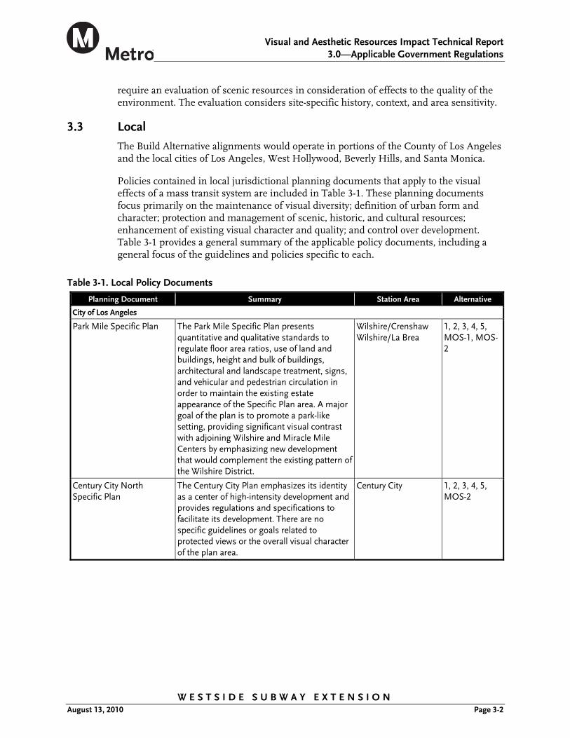
Policies contained in local jurisdictional planning documents that apply to the visual effects of a mass transit system are included in Table 3-1. These planning documents focus primarily on the maintenance of visual diversity; definition of urban form and character; protection and management of scenic, historic, and cultural resources; enhancement of existing visual character and quality; and control over development. Table 3-1 provides a general summary of the applicable policy documents, including a general focus of the guidelines and policies specific to each.
Table 3-1. Local Policy Documents
Planning Document Summary Station Area Alternative
City of Los Angeles
Park Mile Specific Plan The Park Mile Specific Plan presents quantitative and qualitative standards to regulate floor area ratios, use of land and buildings, height and bulk of buildings, architectural and landscape treatment, signs, and vehicular and pedestrian circulation in order to maintain the existing estate appearance of the Specific Plan area. A major goal of the plan is to promote a park-like setting, providing significant visual contrast with adjoining Wilshire and Miracle Mile Centers by emphasizing new development that would complement the existing pattern of the Wilshire District.
Wilshire/Crenshaw Wilshire/La Brea
1, 2, 3, 4, 5, MOS-1, MOS-2
Century City North Specific Plan
The Century City Plan emphasizes its identity as a center of high-intensity development and provides regulations and specifications to facilitate its development. There are no specific guidelines or goals related to protected views or the overall visual character of the plan area.
Century City 1, 2, 3, 4, 5, MOS-2
Visual and Aesthetic Resources Impact Technical Report
3.0—Applicable Government Regulations
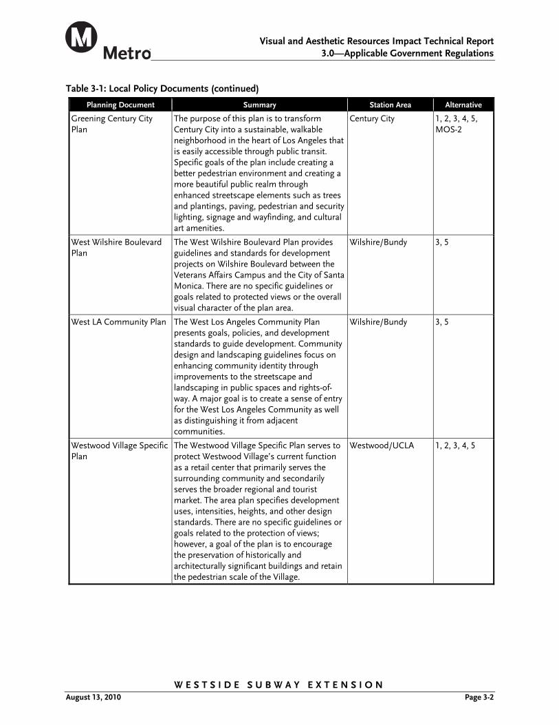
Table 3-1: Local Policy Documents (continued)
W E S T S I D E S U B W A Y E X T E N S I O N August 13, 2010 Page 3-2
Planning Document Summary Station Area Alternative
Greening Century City Plan
The purpose of this plan is to transform Century City into a sustainable, walkable neighborhood in the heart of Los Angeles that is easily accessible through public transit. Specific goals of the plan include creating a better pedestrian environment and creating a more beautiful public realm through enhanced streetscape elements such as trees and plantings, paving, pedestrian and security lighting, signage and wayfinding, and cultural art amenities.
Century City 1, 2, 3, 4, 5, MOS-2
West Wilshire Boulevard Plan
The West Wilshire Boulevard Plan provides guidelines and standards for development projects on Wilshire Boulevard between the Veterans Affairs Campus and the City of Santa Monica. There are no specific guidelines or goals related to protected views or the overall visual character of the plan area.
Wilshire/Bundy 3, 5
West LA Community Plan The West Los Angeles Community Plan presents goals, policies, and development standards to guide development. Community design and landscaping guidelines focus on enhancing community identity through improvements to the streetscape and landscaping in public spaces and rights-of-way. A major goal is to create a sense of entry for the West Los Angeles Community as well as distinguishing it from adjacent communities.
Wilshire/Bundy 3, 5
Westwood Village Specific Plan
The Westwood Village Specific Plan serves to protect Westwood Village’s current function as a retail center that primarily serves the surrounding community and secondarily serves the broader regional and tourist market. The area plan specifies development uses, intensities, heights, and other design standards. There are no specific guidelines or goals related to the protection of views; however, a goal of the plan is to encourage the preservation of historically and architecturally significant buildings and retain the pedestrian scale of the Village.
Westwood/UCLA 1, 2, 3, 4, 5

Visual and Aesthetic Resources Impact Technical Report
3.0—Applicable Government Regulations
Table 3-1: Local Policy Documents (continued)
W E S T S I D E S U B W A Y E X T E N S I O N August 13, 2010 Page 3-3
Planning Document Summary Station Area Alternative
City of Beverly Hills
Beverly Hills General Plan Visual resources are discussed in Chapter Four of the Beverly Hills General Plan. The City’s greatest aesthetic resource is its rich architectural heritage and elaborate network of landscaping and scenic vistas. The City has several policies to achieve its goal of maintaining and protecting significant visual and aesthetic resources, which contribute to the identity and character of Beverly Hills. Specific policies relate to the protection of scenic views and parkways; landscaping; minimizing the removal of existing resources; and standards for new development, lighting, and glare.
Wilshire/La Cienega Wilshire/Rodeo
1, 2, 3, 4, 5, MOS-2
City of Santa Monica
Santa Monica Land Use and Circulation Element
The Santa Monica Land Use and Circulation Element encompasses the community’s vision for the City’s future and provides several goals and policies to maintain the City’s character, protect its neighborhoods, manage its transportation system, and encourage additional housing. One of the City’s goals is to transform Wilshire Boulevard into Santa Monica’s premier pedestrian/transit boulevard. The vision for Wilshire Boulevard is that of a “complete street” with a continuous landscaped center median, enhanced pedestrian sidewalks and crosswalks, and efficient transit service. The vision also includes new transit shelters and state-of-the-art electronic information kiosks to add to the streetscape while making public transportation more convenient, inviting, and pleasant to use. Additionally streets such as Wilshire Boulevard provide the predominant Downtown open space and direct and define views to the ocean and the mountains to the north.
Wilshire/26th Wilshire/16th Wilshire/4th
3, 5
3.3.1 Scenic Corridors
In general, citywide policies on scenic views or vistas aim to protect the panoramic public view access to natural features, including views of the ocean, striking or unusual natural terrain, or unique urban or historic features. Appendix E, Inventory of Designated Scenic Highways, of the Transportation Element, of the LA City General Plan designates 69 corridor segments as scenic highways. Of these 69 corridor segments, three are proposed to have stations located along them.

Visual and Aesthetic Resources Impact Technical Report
3.0—Applicable Government Regulations
W E S T S I D E S U B W A Y E X T E N S I O N August 13, 2010 Page 3-2
3.3.1.1 City of Los Angeles Scenic corridors in the City of Los Angeles include Avenue of the Stars, Santa Monica Boulevard, and Wilshire Boulevard.
Avenue of the Stars is designated scenic between Santa Monica and Pico Boulevards. The scenic features within this area include a wide landscaped median and fountains. Stations located along this segment include Century City Avenue of the Stars and Century City Constellation.
Santa Monica Boulevard is designated scenic between Sepulveda Boulevard and the Los Angeles City boundary with Beverly Hills. The unique urban features along this corridor segment include the wide center medians and access to shops and buildings. Stations located along this segment include Century City Avenue of the Stars.
Wilshire Boulevard is designated scenic between Sycamore and Fairfax Avenues. This segment is considered the Miracle Mile Community Design Overlay District. The Miracle Mile is characterized by numerous high-rise office buildings, neighborhood retail, well-known entertainment establishments, and the city’s greatest concentration of museums. In addition, it contains some of the best examples of Art Deco architecture in the country. The Miracle Mile Community Design Overlay District Design Guidelines & Standards intend to promote and enhance the identity of the District. Specific goals include preserving and enhancing the physical appearance of the corridor, encouraging development that adds to the pedestrian-friendly retail environment, and preserving architecturally significant buildings. Stations located along this corridor include Wilshire/La Brea and Wilshire/Fairfax.
3.3.1.2 City of West Hollywood There are no city-designated scenic highways or byways located in the city of West Hollywood.
3.3.1.3 City of Beverly Hills Amendments to the city’s existing general plan document indicate that there are no scenic highways designated in the city.
3.3.1.4 City of Santa Monica In general, citywide policies on scenic vistas focus on protecting the city’s natural resources as well as views along significant streets and boulevards. The 1975 Scenic Corridors Element identified seven potential scenic corridors within the city, including Wilshire Boulevard from the Santa Monica city boundary to Ocean Avenue. The Scenic Corridors Element lays the groundwork for the preparation and adoption of a specific corridor plan based on analysis of the corridor’s resources, characteristics, potential, and consequences of a scenic corridor designation. However, no such plans have been prepared to date and, as a result, there are no officially designated scenic highways in the city.


Visual and Aesthetic Resources Impact Technical Report
4.0—Affected Environment
W E S T S I D E S U B W A Y E X T E N S I O N August 13, 2010 Page 4-3
4.0 AFFECTED ENVIRONMENT
This section describes viewer characteristics and sensitivity, as well as the existing visual character, quality, and key views in the study area. The study area for visual and aesthetics consists of the viewsheds around station entrances (elevator/escalator enclosures), ventilation structures, and locations where maintenance and operation facility sites, staging areas, or other support facilities are proposed. Viewsheds are the areas from which the project elements and alternatives could be viewed. In general, the viewsheds for the Project encompass the foreground viewing distance (generally along the project alignment and within a half mile of a given viewpoint), but this may vary depending upon elements in the landscape (e.g., terrain, vegetation, and buildings that can block views of objects).
The existing visual quality of each station area has been categorized as low, moderate, or high. The three quality categories are as follows:
Low Visual Quality. Areas that have low visual quality exhibit features that seem visually out of place, lack visual coherence, do not have a compositional harmony, and contain eyesores.
Moderate Visual Quality. These areas are generally pleasant appearing but may lack an overall distinctiveness, memorability, drama, and compositional harmony, or may simply be common and ordinary landscapes that lack strong and consistent architectural and urban design features.
High Visual Quality. These areas tend to be memorable, distinctive, unique (in a positive way), intact natural or park-like areas, or urban areas with strong and consistent architectural and urban design features.
4.1 Viewer Characteristics and Sensitivity
The viewer population is a mix of major viewer groups, which includes residents, tourists, shoppers, commuters, people taking advantage of the cultural and culinary attractions in the study area, and people who work in the area. Commuters, including bicyclists and motorists on streets, generally have lower expectations and sensitivity about visual quality than other viewer groups because they are focused on driving in traffic. The remaining viewers would have higher expectations about the visual quality of the environment either because their activities are elective or because they spend a great deal of time in the study area.
Viewer sensitivity or concern is based on the visibility of resources in the landscape, the proximity of viewers to the visual resource, the relative elevation of the viewers compared to the visual resource, the frequency and duration of views, the number of viewers, and the types and expectations of individuals. In considering visual impacts of the Project’s alternatives, key views and visually prominent features have been assessed to determine how they would most influence impact perception.
4.2 Visual Setting
The Westside Subway Extension is primarily a subway project where the train would travel underground. Because the visual impacts would be primarily limited to station
Visual and Aesthetic Resources Impact Technical Report
4.0—Affected Environment
W E S T S I D E S U B W A Y E X T E N S I O N August 13, 2010 Page 4-4
areas, most of the visual setting discussion is focused on these areas. However, the maintenance facility sites are also discussed.
Overall, the visual setting within the study area varies and includes a combination of residential, commercial, transportation and utilities, industrial, and public/institutional buildings of varied height and scale. Residences, both single-family residences and multistory apartments and condominiums, are the primary land use in the study area. Commercial buildings are concentrated along major roadways, such as Wilshire and Santa Monica Boulevards and La Brea, Fairfax, and La Cienega Avenues.
4.2.1 Wilshire/Crenshaw Station Area
The Wilshire/Crenshaw Station area is in an area that is characterized by a mix of three- to six-story commercial/office buildings that front Wilshire Boulevard. Smaller commercial buildings and residences comprise the residential neighborhoods to the north and south, where there is a mix of building sizes and densities, including single-family houses, duplexes, and multi-story apartment complexes.
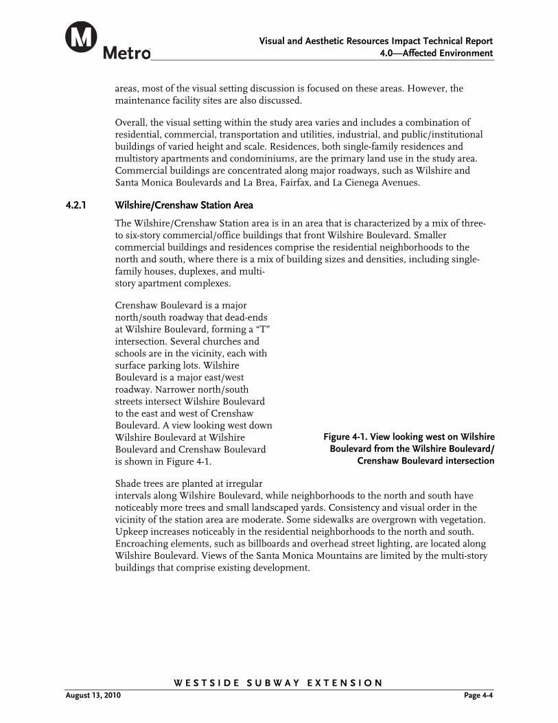
Crenshaw Boulevard is a major north/south roadway that dead-ends at Wilshire Boulevard, forming a “T” intersection. Several churches and schools are in the vicinity, each with surface parking lots. Wilshire Boulevard is a major east/west roadway. Narrower north/south streets intersect Wilshire Boulevard to the east and west of Crenshaw Boulevard. A view looking west down Wilshire Boulevard at Wilshire Boulevard and Crenshaw Boulevard is shown in Figure 4-1.
Shade trees are planted at irregular intervals along Wilshire Boulevard, while neighborhoods to the north and south have noticeably more trees and small landscaped yards. Consistency and visual order in the vicinity of the station area are moderate. Some sidewalks are overgrown with vegetation. Upkeep increases noticeably in the residential neighborhoods to the north and south. Encroaching elements, such as billboards and overhead street lighting, are located along Wilshire Boulevard. Views of the Santa Monica Mountains are limited by the multi-story buildings that comprise existing development.
Figure 4-1. View looking west on Wilshire
Boulevard from the Wilshire Boulevard/Crenshaw Boulevard intersection

Visual and Aesthetic Resources Impact Technical Report
4.0—Affected Environment
W E S T S I D E S U B W A Y E X T E N S I O N August 13, 2010 Page 4-5
Figure 4-3. View of the E. Clem Wilson
Building on northeast corner of Wilshire Boulevard and S. La Brea Avenue
The Hancock Park residential area lies directly north of the station area. It includes many single-family residences that were built in the 1920s to 1930s. The Harbor Insurance and Los Altos Apartment buildings are important visual resources in the station area. Figure 4-2 shows the Los Altos Apartments. Other notable visual resources in this area include the Modern Scottish Rite Temple, the Queen Anne Higgins/Verbeck/Hirsch, the Gothic Revival Wilshire United Methodist Church, and the Renaissance Revival Ebell of Los Angeles Women’s Club. The Wilshire/Crenshaw Station area’s existing visual quality is moderate due to its generally pleasant appearance.
4.2.2 Wilshire/La Brea Station Area
The Wilshire/La Brea Station area is located within the Miracle Mile District of Los Angeles. It includes a variety of retail and mixed-use buildings of varying heights (ranging from one to eleven stories) and large surface parking lots along the streets and behind retail stores. Several vacant undeveloped lots are also located along Wilshire Boulevard. Northwest of the Wilshire Boulevard/S. La Brea Avenue intersection, residential buildings vary in size, many with landscaped courtyards. Buildings on Wilshire Boulevard are generally taller than buildings on S. La Brea Avenue, which are mostly one- to two-story businesses.
Occasional intermittent palm trees along the roadway serve as visual amenities. Neighborhoods to the north and south have denser landscaping with shade trees, planted parkways, and small yards.
While there is no apparent architectural design aesthetic in the area, the prevailing architectural style of the station area is Art Deco. Notable Art Deco buildings in the area include the E. Clem Wilson (or “Samsung”) building (Figure 4-3), which has a large iconic vibrant neon sign atop it; the Dominguez-Wilshire building; the historical El Rey Theater (Art Deco/Streamline); and the Wilshire Tower.
Figure 4-2. View of Los Altos Apartments and vacant lot at the northeast corner of S. Irving
Boulevard and Wilshire Boulevard

Visual and Aesthetic Resources Impact Technical Report
4.0—Affected Environment
W E S T S I D E S U B W A Y E X T E N S I O N August 13, 2010 Page 4-6
Figure 4-4 shows the Dominguez Wilshire Building. The Prudential Insurance building is an example of the Modern architecture of the area. All of these visual resources are visible from Wilshire Boulevard and/or S. La Brea Avenue, and are prominent features of the area.
Figure 4-5 shows the view north on S. La Brea Avenue to the Santa Monica Mountains. On clear days there are views east down Wilshire Boulevard to Downtown Los Angeles and farther south to the Culver City Hills. The Samsung neon sign is a prominent visual feature at the Wilshire Boulevard/S. La Brea Avenue intersection. Encroaching elements, such as billboards and overhead street lighting, are located along Wilshire Boulevard. The Wilshire/La Brea Station area’s existing visual quality is moderate due to its generally pleasant appearance but a lack of strong consistent architectural and urban design features.
4.2.3 Wilshire/Fairfax Station Area
The Wilshire/Fairfax Station area is home to several regional visual resources, including the Los Angeles County Museum of Art (LACMA), the La Brea Tar Pits and surrounding Hancock Park, and the Petersen Automotive Museum. Buildings along Wilshire Boulevard and north of S. Fairfax Avenue are multi-story, from one to fifteen stories, and include a mix of commercial, retail, and office uses. Wilshire Boulevard is lined with small, low-rise retail buildings on the north side of the street and larger, taller buildings on the south side. East of S. Fairfax Avenue, the museums and La Brea Tar Pits are prominent visual resources along Wilshire Boulevard.
Densely developed residential neighborhoods with single-family residences on small lots lie north and south of Wilshire Boulevard. Northeast of Wilshire Boulevard is the historical Park La Brea apartment development, which contains over 4,000 apartments in garden style and high-rise buildings within a gated perimeter. Southeast of Wilshire Boulevard lay more dense residential neighborhoods with single-family and small multifamily buildings. A large parking lot is located on the south side of Wilshire Boulevard across from the LACMA. Several small parking lots lie west of Wilshire Boulevard, behind shops and abutting the street front.
Figure 4-4. View of the Dominguez Wilshire Building
Figure 4-5. View looking north on S. La Brea
Avenue to Santa Monica Mountains

Visual and Aesthetic Resources Impact Technical Report
4.0—Affected Environment
W E S T S I D E S U B W A Y E X T E N S I O N August 13, 2010 Page 4-7
The station area includes several buildings with noteworthy architectural styles, including the Petersen Automotive Museum, the LACMA building, May Company/LACMA West building, and Johnie’s Coffee Shop. Johnie’s is considered to be a landmark structure, a well known example of Googie style architecture and is listed under the National Register of Historic Places and California Register of Historic Resources.
The May Company building and Johnie’s Coffee shop, both shown in Figure 4-6, are two prominent visual resources of vastly different scales. Johnie’s is a one-story blue and white striped building with a prominent lighted sign and a roof sloping up toward Wilshire Boulevard. The May Company Building is a four-story commercial structure with a defining gold, cylindrical architectural element, located on the corner of Wilshire Boulevard and Fairfax Avenue.
As shown in Figure 4-7, prominent rows of palm and shade trees are clustered in front of LACMA and the Tar Pits. Figure 4-7 shows the view east along Wilshire Boulevard, in front of the new LACMA building, looking toward the La Brea Tar Pits.
Tall palm trees and other street trees are planted in center medians along Wilshire Boulevard, creating a contrasting visual element. Hancock Park, the major green open space, is landscaped and includes several mature trees. Prominent views are north along S. Fairfax Avenue to the Santa Monica Mountains and south toward Culver City. Views to the east and west, looking down the Wilshire Boulevard corridor, are dominated by intermittent office towers. Commercial signage, overhead street lights, and traffic signals are also prominent visual elements along Wilshire Boulevard (Figure 4-6). The Wilshire/Fairfax Station area’s existing visual quality is moderate due to its general pleasant appearance, but lack of strong consistent architectural and urban design features.
Figure 4-6. View of Johnie’s Coffee Shop and May Company at Wilshire Boulevard and S. Fairfax Avenue
Figure 4-7. View looking east along
Wilshire, in front of the new LACMA Building, toward La Brea Tar Pits
Visual and Aesthetic Resources Impact Technical Report
4.0—Affected Environment
W E S T S I D E S U B W A Y E X T E N S I O N August 13, 2010 Page 4-8
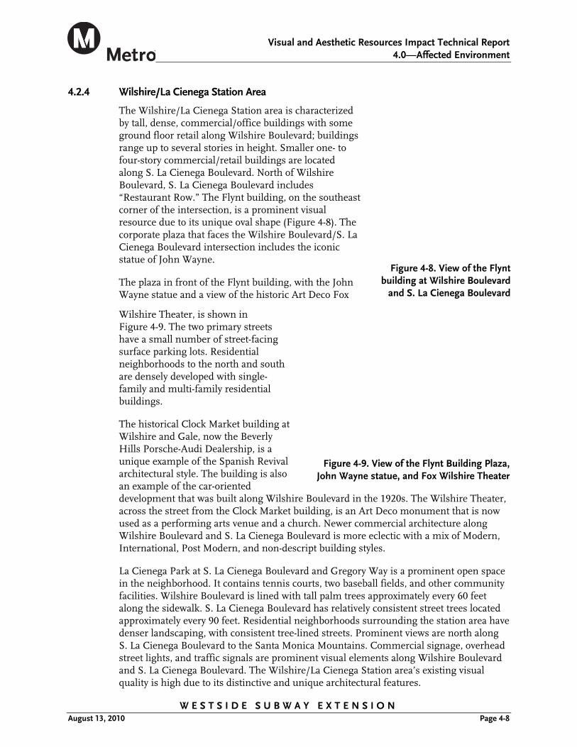
4.2.4 Wilshire/La Cienega Station Area
The Wilshire/La Cienega Station area is characterized by tall, dense, commercial/office buildings with some ground floor retail along Wilshire Boulevard; buildings range up to several stories in height. Smaller one- to four-story commercial/retail buildings are located along S. La Cienega Boulevard. North of Wilshire Boulevard, S. La Cienega Boulevard includes “Restaurant Row.” The Flynt building, on the southeast corner of the intersection, is a prominent visual resource due to its unique oval shape (Figure 4-8). The corporate plaza that faces the Wilshire Boulevard/S. La Cienega Boulevard intersection includes the iconic statue of John Wayne.
The plaza in front of the Flynt building, with the John Wayne statue and a view of the historic Art Deco Fox
Wilshire Theater, is shown in Figure 4-9. The two primary streets have a small number of street-facing surface parking lots. Residential neighborhoods to the north and south are densely developed with single-family and multi-family residential buildings.
The historical Clock Market building at Wilshire and Gale, now the Beverly Hills Porsche-Audi Dealership, is a unique example of the Spanish Revival architectural style. The building is also an example of the car-oriented development that was built along Wilshire Boulevard in the 1920s. The Wilshire Theater, across the street from the Clock Market building, is an Art Deco monument that is now used as a performing arts venue and a church. Newer commercial architecture along Wilshire Boulevard and S. La Cienega Boulevard is more eclectic with a mix of Modern, International, Post Modern, and non-descript building styles.
La Cienega Park at S. La Cienega Boulevard and Gregory Way is a prominent open space in the neighborhood. It contains tennis courts, two baseball fields, and other community facilities. Wilshire Boulevard is lined with tall palm trees approximately every 60 feet along the sidewalk. S. La Cienega Boulevard has relatively consistent street trees located approximately every 90 feet. Residential neighborhoods surrounding the station area have denser landscaping, with consistent tree-lined streets. Prominent views are north along S. La Cienega Boulevard to the Santa Monica Mountains. Commercial signage, overhead street lights, and traffic signals are prominent visual elements along Wilshire Boulevard and S. La Cienega Boulevard. The Wilshire/La Cienega Station area’s existing visual quality is high due to its distinctive and unique architectural features.
Figure 4-8. View of the Flynt building at Wilshire Boulevard
and S. La Cienega Boulevard
Figure 4-9. View of the Flynt Building Plaza, John Wayne statue, and Fox Wilshire Theater