29 Native Vegetation Cover for Rural Residential Land · 29 Native Vegetation Cover for Rural...
31
Wagga Wagga Development Control Plan 2005 _______________________________________________________________________________ _ 29 Native Vegetation Cover for Rural Residential Land Flowchart of Responsibilities and Actions 29.1 INTRODUCTION 29.1.1 Title 29.1.2 Land to Which the Plan Applies 29.1.3 Aims of the Plan 29.1.4 Achievement of Aims 29.1.5 Relationship to other Planning Instruments and Documents 29.1.6 Definitions Used in the Plan 29.2 INFORMATION REQUIREMENTS 29.2.1 Application of this Section 29.2.2 Information Requirements for a Developer 29.2.3 Information Requirements for a New Landowner 29.3 REQUIREMENTS FOR PROTECTING EXISTING NATIVE VEGETATION 29.3.1 Application of this Section 29.3.2 Protection of Existing Native Vegetation 29.4 REQUIREMENTS FOR ESTABLISHING NEW NATIVE VEGETATION 29.4.1 Application of this Section 29.4.2 Establishment of New Native Vegetation 29.4.2.1 General 29.4.2.2 Suitable Species 29.4.2.3 Rural Land Capability Classes and Required Vegetation Cover 29.4.2.4 Planting Seedlings 29.4.2.5 Direct Seeding 29.4.2.6 Natural Regeneration 29.4.2.7 New Native Vegetation in Existing Native Grasslands 29.5 ACHIEVING SATISFACTORY PERFORMANCE AND CERTIFYING COMPLIANCE 29.5.1 Application of this Section 29.5.2 Responsibility for Assessment 29.5.3 Standards and Certification of Work 29.5.4 Fee Schedule for Assessment ATTACHMENTS 1 Map of Areas where this Plan May Apply 2 Rural Land Capability Class Definitions Last updated December 2005 Chapter 29 Page 29.1
Transcript of 29 Native Vegetation Cover for Rural Residential Land · 29 Native Vegetation Cover for Rural...

Wagga Wagga Development Control Plan 2005 _______________________________________________________________________________
_
29 Native Vegetation Cover for Rural Residential Land Flowchart of Responsibilities and Actions
29.1 INTRODUCTION 29.1.1 Title 29.1.2 Land to Which the Plan Applies 29.1.3 Aims of the Plan 29.1.4 Achievement of Aims 29.1.5 Relationship to other Planning Instruments and Documents 29.1.6 Definitions Used in the Plan
29.2 INFORMATION REQUIREMENTS 29.2.1 Application of this Section 29.2.2 Information Requirements for a Developer 29.2.3 Information Requirements for a New Landowner 29.3 REQUIREMENTS FOR PROTECTING EXISTING NATIVE VEGETATION 29.3.1 Application of this Section 29.3.2 Protection of Existing Native Vegetation 29.4 REQUIREMENTS FOR ESTABLISHING NEW NATIVE VEGETATION 29.4.1 Application of this Section 29.4.2 Establishment of New Native Vegetation
29.4.2.1 General 29.4.2.2 Suitable Species 29.4.2.3 Rural Land Capability Classes and Required Vegetation Cover 29.4.2.4 Planting Seedlings 29.4.2.5 Direct Seeding 29.4.2.6 Natural Regeneration 29.4.2.7 New Native Vegetation in Existing Native Grasslands
29.5 ACHIEVING SATISFACTORY PERFORMANCE AND CERTIFYING COMPLIANCE 29.5.1 Application of this Section 29.5.2 Responsibility for Assessment 29.5.3 Standards and Certification of Work 29.5.4 Fee Schedule for Assessment ATTACHMENTS 1 Map of Areas where this Plan May Apply 2 Rural Land Capability Class Definitions
Last updated December 2005 Chapter 29 Page 29.1

Wagga Wagga Development Control Plan 2005 _______________________________________________________________________________
3 Developer Contributions and Assessment Fees 4 Native Vegetation Profiles
Last updated December 2005 Chapter 29 Page 29.2

Wagga Wagga Development Control Plan 2005 _______________________________________________________________________________
Flowchart of Responsibilities and Actions
Does this DCP apply to the land in question?
(Section 1.2)
No s
No s
No
No further action required under this DCP.
Any areas of native vegetation >2 hectares? (Section 3.2)
Developer to fence areas. (Section 3.2)
Developer to assess existing native vegetation cover for each rural land capability class. Does it meet minimum cover requirements?
(Section 4.2.3)
Developer lodges ½ the dollar cost revegetation works in a Council trust fund
or developer plants ½ the required vegetation
(Section 4.2.1)
New owner completes revegetation works w2 years of receiving consent for the construof a new dwelling. If works satisfadeveloper contribution paid to new landown
(Section 4.2.1)
Last updated December 2005
Ye
Ye
Yes
No further action required under this DCP.
of ,
.
ithin ction
ctory, er.
Chapter 29 Page 29.3

Wagga Wagga Development Control Plan 2005 _______________________________________________________________________________
29.1 INTRODUCTION 29.1.1 TITLE
The name of this plan is the “Wagga Wagga Development Control Plan No. 11 - Native Vegetation Cover for Rural Residential Land”.
29.1.2 LAND TO WHICH THE PLAN APPLIES
This plan applies to all land within the Wagga Wagga Local Government Area where rural residential or smallholding development is permissible. These areas are defined in the City of Wagga Wagga Development Control Plan 2005.
Within the shaded area shown in Attachment 1, this plan applies to:
• any parcel of land created by subdivision as from 23rd October 2000, or
• any parcel of land not created by development consent where a new dwelling is proposed.
29.1.3 AIMS OF THE PLAN
a. To conserve existing native vegetation and establish new native vegetation on rural residential land in order to reduce the potential for dryland salinity, groundwater recharge and soil erosion, and to maintain and enhance biodiversity.
b. To define Wagga Wagga City Council’s development standards for the conservation of existing native vegetation and establishment of new native vegetation on rural residential land.
c. To define the responsibilities of developers and new landowners regarding the conservation of existing native vegetation and establishment of new native vegetation on rural residential land.
d. To advise on the most suitable species for particular sites and the most appropriate means of establishing and protecting them.
e. To compliment the Wagga Wagga Draft Natural Resource Management Plan by providing a statutory planning framework for the establishment of minimum native vegetation cover levels on rural residential land.
29.1.4 ACHIEVEMENT OF AIMS
The above aims are achieved by requiring:
• minimum native vegetation cover levels for the different rural land capability classes,
Last updated December 2005 Chapter 29 Page 29.4

Wagga Wagga Development Control Plan 2005 _______________________________________________________________________________
• the developer to fence out existing stands of native vegetation with areas greater than 2 hectares for the purpose of controlling access by stock,
• the new landowner to establish new native vegetation to meet the minimum native vegetation cover levels for each rural land capability class,
• the new landowner to fence out the newly established native vegetation to control access by stock,
• new native vegetation to be established at a rate of 1,000 plants per hectare on land requiring 100% vegetation cover, with a pro rata reduction in the level of planting on land where less than 100 % cover is required,
• new native vegetation to be established using the ratio of 1 tree to 4 shrubs.
Developers are encouraged to consider low-cost options to raise the level of native vegetation prior to subdivision or the construction of a new dwelling on an existing portion. Fencing of an area some years before works are planned to allow natural regeneration may be sufficient to achieve a particular vegetation cover level. In addition, a range of incentives (e.g. tax deductions, tax rebates, grants) are available for revegetation and vegetation protection works through various government programs.
29.1.5 RELATIONSHIP TO OTHER PLANNING INSTRUMENTS AND DOCUMENTS
29.1.5.1 Local Environmental Plans
This Development Control Plan (DCP) relates to the Wagga Wagga Local Environmental Plan 1985 as amended and the Wagga Wagga Rural Local Environmental Plan 1991 as amended. In the event of any inconsistency, the provisions of the Local Environmental Plans shall prevail.
29.1.5.2 Wagga Wagga Draft Natural Resource Management Plan
The Wagga Wagga Draft Natural Resource Management Plan specifies vegetation cover recommendations for different rural land capability classes. This DCP compliments the Wagga Wagga Draft Natural Resource Management Plan by providing a statutory planning framework specifically directed at establishing minimum native vegetation cover requirements for rural residential land. In the event of any inconsistency, the provisions of this DCP shall prevail.
29.1.5.3 Mid Murrumbidgee Catchment - Proposals for the Integrated Management of Soil Erosion and Related Land Degradation
The Mid Murrumbidgee Catchment document of the Department of Land and Water Conservation (1997) states that the vegetation cover recommendations outlined in the Wagga Wagga Draft Natural Resource Management Plan are applicable across the entire Wagga Wagga Local Government Area.
Last updated December 2005 Chapter 29 Page 29.5

Wagga Wagga Development Control Plan 2005 _______________________________________________________________________________
29.1.5.4 Wagga Wagga City Council Tree Preservation Order
Following the establishment of native vegetation cover requirements under the provisions of this DCP, Council’s Tree Preservation Order provides subsequent controls over the clearing of trees in the specified sub-zones.
29.1.5.5 Native Vegetation Conservation Act 1997
Following the establishment of native vegetation cover requirements under the provisions of this DCP, the NSW Native Vegetation Conservation Act 1997 provides subsequent controls over the clearing of trees in the specified sub-zones.
29.1.6 DEFINITIONS USED IN THE PLAN
“biodiversity” means the variety of life forms (plants, animals, micro-organisms), the genes they contain, and the ecosystems they form.
“developer” means an individual, company or other entity subdividing land, or constructing a new dwelling on an existing portion, in areas specified in Section 1.2 above.
“development consent” means development consent as defined in the Environmental Planning and Assessment Act 1979.
“DLWC” means the Department of Land and Water Conservation or its equivalent.
“dryland salinity” means the process of natural salts rising through subsurface soil layers with rising groundwater to accumulate at or near the ground surface. Dryland salinity is a consequence of water escaping down past the root zone of plants, allowing excess water to enter the groundwater system. This leakage causes the watertable to rise through the soil profile.
“existing portion” means any parcel of land not created by development consent in areas specified in Section 1.2 above.
“fire break” means any natural or man-made gap between combustible materials which may limit the movement of fire across the landscape.
“groundwater recharge” means the process of excess water leaking past the root zone and into the groundwater system, resulting in rising water tables.
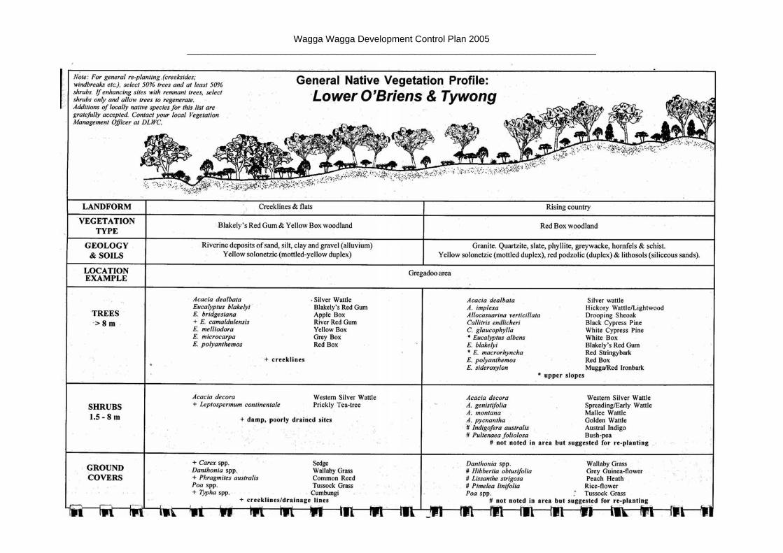
“locally native plants” means plant species referred to in native vegetation profiles for particular sub-catchments, as presented in the South West Slopes Revegetation Guide 1998 (Edited by Fleur Stelling and available from Greening Australia).
“native grasslands” means areas where more than 50% of the ground cover is native grasses and/or other native herbaceous plants.
“native vegetation” means vegetation that is indigenous to the local area, including both trees and shrubs.
Last updated December 2005 Chapter 29 Page 29.6

Wagga Wagga Development Control Plan 2005 _______________________________________________________________________________
“native vegetation profile” means a profile of the landscape which shows the likely occurrence of locally native plant species, as presented in the South West Slopes Revegetation Guide 1998.
“new landowner” means an individual, company or other entity purchasing land subdivided after 23rd October 2000, or constructing a new dwelling on an existing portion, in areas specified in Section 1.2 above.
“noxious plant” means plants declared noxious by the Wagga Wagga City Council under the Noxious Weeds Act 1993.
“overstorey” means plants with a potential height at maturity of greater than 8 metres. These species are identified in the native vegetation profiles. Overstorey species are the taller component of a vegetation community, occurring above the understorey.
“pest animal” means any member of the animal kingdom declared by a pest control order to be a pest under the Rural Lands Protection Act 1998.
“revegetation works” means all works associated with the planting, direct seeding or natural regeneration of a site including ground ripping, weed control, perimeter fencing, seedling planting and direct seeding.
“rural land capability class” means the categorisation of the capability of lands for sustained agricultural production, as defined by the NSW Department of Land and Water Conservation (see Attachment 2 for details).
“rural residential” means the land specified in Section 1.2 above.
“soil erosion” means the loss of excessive amounts of soil from a site due to disturbance by water or wind.
“stock” means the range of domesticated animals that are found in the area, including cattle, sheep, horses, goats, donkeys, pigs, deer and alpaca.
“understorey” means plants with a potential height at maturity no greater than 8 metres. These species are identified in the native vegetation profiles. Understorey species are the shrubby component of a vegetation community, occurring underneath the overstorey.
“WWCC” means Wagga Wagga City Council.
29.2 INFORMATION REQUIREMENTS 29.2.1 APPLICATION OF THIS SECTION
This Section specifies the information required by Wagga Wagga City Council when a developer lodges a development application or when a new landowner lodges a development/construction application for a new dwelling.
Last updated December 2005 Chapter 29 Page 29.7

Wagga Wagga Development Control Plan 2005 _______________________________________________________________________________
29.2.2 INFORMATION REQUIREMENTS WHEN A DEVELOPER LODGES A DEVELOPMENT APPLICATION
Please note that a developer is defined as individual, company or other entity subdividing land, or constructing a new dwelling on an existing portion, in areas specified in Section 29.1.2 above.
The following information is to be submitted with a development application:
i) Plans/maps showing:
Last updated December 2005 Chapter 29
• the different rural land capability classes on the block at a minimum scale of 1:25,000 (available from DLWC or WWCC).
• the existing native vegetation cover on the block.
• any proposed clearing of existing native vegetation on the block.
• the areas of existing native vegetation that are to be fenced out (i.e. areas >2 hectares), including locations of existing fences and proposed additional fences.
• the location of any proposed fire breaks.
ii) Tables showing:
• the names of the main overstorey and understorey species making up the existing native vegetation cover.
• the area (in hectares) of each rural land capability class.
• the percentage area of existing native vegetation cover within each rural land capability class. Some of this information, based on air photo interpretation, is available from DLWC and WWCC. Such information may need to be supplemented with recent aerial photographs and on-site visits.
• for the entire un-subdivided block, the numbers of plants that need to be planted within each rural land capability class to reach the minimum native vegetation cover requirements.
• for each lot, the number of plants that need to be planted within each rural land capability class to reach the minimum native vegetation cover requirements (as outlined in Section 29.4.2.2).
29.2.3 INFORMATION REQUIREMENTS WHEN A NEW LANDOWNER LODGES A DEVELOPMENT/CONSTRUCTION APPLICATION FOR A NEW DWELLING
Where the assessment of native vegetation cover by the developer indicates that further vegetation cover is required, the information listed below is to be submitted by the new landowner with a development/construction application for a new dwelling.
Page 29.8

Wagga Wagga Development Control Plan 2005 _______________________________________________________________________________
In the case of existing portions, the developer may also be the new landowner; therefore, the information specified in this Section is required at the same time as the information specified in Section 33.2.2.
i) Plans showing:
• the existing native vegetation cover on the lot.
• the proposed location of revegetation works on the lot.
• the location of any proposed fire breaks.
ii) Tables showing:
• the names of the main overstorey and understorey species making up the existing native vegetation cover.
• a list of species to be established.
• the area (in hectares) to be planted and the number of seedlings of the different species, for each rural land capability class.
iii) Descriptions of:
• the method of revegetation.
• the timing of the various components of the fencing and revegetation works.
29.3 REQUIREMENTS FOR PROTECTING EXISTING NATIVE VEGETATION
29.3.1 APPLICATION OF THIS SECTION
This Section specifies the actions to be taken by developers and new landowners for the protection of existing native vegetation.
29.3.2 PROTECTION OF EXISTING NATIVE VEGETATION
Areas of existing native vegetation greater than 2 hectares are to be protected. The developer is required to fence these areas out with a stockproof fence (and gates). The identification of areas greater than 2 hectares is to take place on the un-subdivided block. If a covenant is used to either exclude stock from lots or only allow stock onto lots for limited grazing for fuel hazard and weed reduction as per the conditions below, fencing of the existing native vegetation on those lots is not required.
Last updated December 2005 Chapter 29 Page 29.9

Wagga Wagga Development Control Plan 2005 _______________________________________________________________________________
Where a developer proposes the establishment of man-made fire breaks on land currently under native vegetation, they must show that the proposed clearing is in accordance with any Bush Fire Risk Management Plan prepared under the Rural Fires Act 1997. If no Plan exists, the developer must show that the appropriate fire management agency (Rural Fire Service or NSW Fire Brigade) has deemed such fire breaks to be necessary. The developer must also show that any necessary vegetation clearing approvals have been obtained from DLWC (under the provisions of Native Vegetation Conservation Act 1997) or WWCC (under the provisions of the Tree Preservation Order). The document “Bush Fire Hazard Reduction in Rural NSW under the Native Vegetation Conservation Act (DLWC, January 2000)” outlines some of the issues concerning fire management.
Any required fencing of existing native vegetation has to be completed before commencement of works or release of survey plans, whichever is appropriate.
The new landowner is required to:
i) maintain any fencing of existing native vegetation in a stockproof condition,
ii) continually suppress and destroy all noxious plants and pest animals on the land by any lawful means. Control of the noxious plants blackberry (Rubus spp.) and briar (Rosa spp.) is particularly important for the health of native vegetation because they harbour noxious animals, especially rabbits, which damage new plant growth. The landowner is also encouraged to control non-noxious weeds.
iii) exclude stock except :
• in respect of fuel hazard reduction, where the appropriate fire management agency (Rural Fire Service or NSW Fire Brigade) deems that the vegetation needs reducing by the use of strategic grazing,
• in respect of weed control, strategic grazing will be allowed using practices recommended by DLWC to manage weeds in native vegetation.
To alert new landowners to their responsibilities and to ensure a formal requirement is in place, the developer is required to place an 88B covenant (with uplifting power vested in Council) on all lots created outlining the above conditions.
Areas of existing native vegetation less than 2 hectares are also considered important and new landowners are encouraged to protect and enhance them.
Last updated December 2005 Chapter 29 Page 29.10

Wagga Wagga Development Control Plan 2005 _______________________________________________________________________________
29.4 REQUIREMENTS FOR ESTABLISHING NEW NATIVE VEGETATION 29.4.1 APPLICATION OF THIS SECTION
This Section specifies the actions to be taken by new landowners for the establishment of new native vegetation.
29.4.2 ESTABLISHMENT OF NEW NATIVE VEGETATION
29.4.2.1 General
In general, new landowners are responsible for organising and undertaking the establishment of new native vegetation. This revegetation is required where the assessment of existing cover shows that the minimum requirements have not been met. The work is to be completed within 2 years of Wagga Wagga City Council granting consent for the construction of a new dwelling.
Where a property is subdivided after the adoption date of this Development Control Plan, the new landowners should be notified of any obligations to undertake revegetation works on the Section 149 Planning Certificate and on a covenant placed over the lot by the developer. Details of new native vegetation requirements are to be specified as a condition of development consent for construction of a new dwelling.
In the case of existing portions, where the developer and new landowner are different entities, the new landowner should be notified of any obligations to undertake revegetation works on a covenant placed over the lot by the developer and/or in a property management plan for the lot in question. For existing portions, details of new native vegetation requirements are to be specified as a condition of development consent for construction of a new dwelling.
The costs of establishing new native vegetation are to be shared equally between the new landowner and the developer, through the use of a developer contribution scheme.
The developer is required to set aside 50% of the estimated revegetation costs (based on the use of planted seedlings) in an account administered by WWCC before commencement of works or release of survey plans, whichever is appropriate. The funds are to be used to partially reimburse the new landowner after confirmation that the work has been completed satisfactorily and on presentation of receipts for revegetation work done. WWCC will refund any unused portion of the contribution to the developer. Developer contributions are set out in the Wagga Wagga City Council Management Plan. These contributions are reviewed annually by Council. The contributions for 2000/01 are shown in Attachment 3.
As an alternative to contributing 50% of the revegetation costs, developers can choose to undertake 50% of the estimated revegetation works prior to release of survey plans, following the standards set out in this document. Last updated December 2005 Chapter 29 Page 29.11
Wagga Wagga Development Control Plan 2005 _______________________________________________________________________________
29.4.2.2 Suitable Species
Locally native plants are to be used for the revegetation works. Lists of suitable species are provided in Attachment 4, which have been taken from the South West Slopes Revegetation Guide 1998. The on-ground location of the proposed revegetation areas is to be matched with the appropriate native vegetation profile (e.g. Lake Albert, Wagga Wagga City) and landform description (e.g. ridgeline, higher slope, lower slope, flat, etc) in Attachment 4 to determine the suite of species available for selection. The Director of Environmental Services (WWCC) has delegated authority to vary the selection of species on receipt of a written request outlining the reasons for the proposed variation.
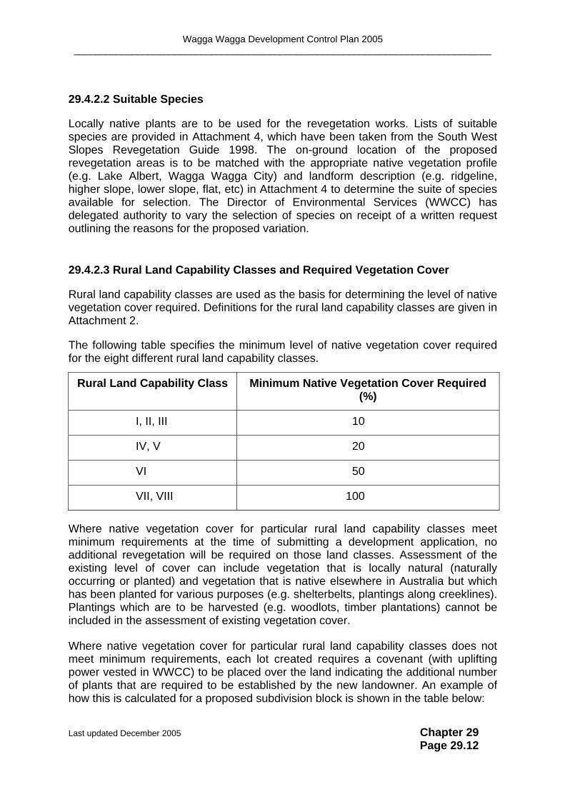
29.4.2.3 Rural Land Capability Classes and Required Vegetation Cover
Rural land capability classes are used as the basis for determining the level of native vegetation cover required. Definitions for the rural land capability classes are given in Attachment 2.
The following table specifies the minimum level of native vegetation cover required for the eight different rural land capability classes.
Rural Land Capability Class Minimum Native Vegetation Cover Required (%)
I, II, III 10
IV, V 20
VI 50
VII, VIII 100
Where native vegetation cover for particular rural land capability classes meet minimum requirements at the time of submitting a development application, no additional revegetation will be required on those land classes. Assessment of the existing level of cover can include vegetation that is locally natural (naturally occurring or planted) and vegetation that is native elsewhere in Australia but which has been planted for various purposes (e.g. shelterbelts, plantings along creeklines). Plantings which are to be harvested (e.g. woodlots, timber plantations) cannot be included in the assessment of existing vegetation cover.
Where native vegetation cover for particular rural land capability classes does not meet minimum requirements, each lot created requires a covenant (with uplifting power vested in WWCC) to be placed over the land indicating the additional number of plants that are required to be established by the new landowner. An example of how this is calculated for a proposed subdivision block is shown in the table below:
Last updated December 2005 Chapter 29 Page 29.12

Wagga Wagga Development Control Plan 2005 _______________________________________________________________________________
Rural Land
Capability Class
Minimum Native
Vegetation Cover
Required
Actual Native Vegetation Cover
of Un-subdivided
Block
Native Vegetation Cover Deficit
1Additional No. of Plants
Needed per Hectare for
each Lot
I 210% 3% 7% 70
II 10% 6% 4% 40
III 10% 10% 0% 0
IV 320% 14% 6% 60
V 20% 28% 0% 0
VI 450% 37% 13% 130
VII 5100% 73% 27% 270
Notes:
1 the figures in this column relate to the number of plants that need to be established on the particular rural land capability class indicated. Planting requirements are not transferable between rural land capability classes.
2 10% native vegetation cover = 100 plants/hectare. 3 20% native vegetation cover = 200 plants/hectare. 4 50% native vegetation cover = 500 plants/hectare. 5 100% native vegetation cover = 1,000 plants/hectare.
Where a new landowner proposes the establishment of man-made fire breaks on land that requires 100% native vegetation cover (i.e. rural land capability classes VII and VIII), they must show that:
1 the location of the fire break is in accordance with any Bush Fire Risk Management Plan prepared under the Rural Fires Act 1997, or
2 the appropriate fire management agency (Rural Fire Service or NSW Fire Brigade) has deemed such fire breaks to be necessary.
29.4.2.4 Planting Seedlings
• The WWCC document “Guidelines for Revegetation - Planted Seedlings” sets out the minimum standards required for planting seedlings. This document is available from the Natural Environment Division of WWCC.
• Where 100% native vegetation cover is required (i.e. land classes VII and VIII), seedling establishment shall be at a rate of 1,000 plants per hectare. As a guide, this equates to a plant spacing of 4.0 x 2.5 metres. Natural landscape features
Last updated December 2005 Chapter 29 Page 29.13

Wagga Wagga Development Control Plan 2005 _______________________________________________________________________________
(e.g. granite outcrops, waterbodies) and approved fire breaks should be subtracted from the area to be planted.
• Where less than 100% native vegetation cover is required (i.e. land classes I to VI), a pro-rata reduction in the planting rate applies (e.g. 50% vegetation cover will require 500 plants/hectare, 10% vegetation cover will require 100 plants/hectare). Plants should be established in clusters to suit the characteristics of the block and the needs of the owner (e.g. along fencelines and creeklines, at break-of-slope, in paddock corners), using similar plant spacing as specified for the areas requiring 100% vegetation cover.
• The planted seedlings are to be a mixture of overstorey species and understorey species at a ratio of 1 overstorey plant to 4 understorey plants. That is, 1 tree to 4 shrubs. For 100% vegetation cover, this equates to a stocking rate of 200 trees and 800 shrubs per hectare.
• A minimum of 3 different overstorey species are to be planted, in approximately equal numbers. A minimum of 5 different understorey species are to be planted and there should not be more than 30%, and less than 10%, of any one species. Planting should include a range species in addition to Eucalyptus and Acacia species. The different species should be evenly spread across the site so that clumps of individual species are avoided, unless there are specific reasons for doing otherwise (e.g. shelterbelts). The Director of Environmental Services (WWCC) has delegated authority to vary the mix of species on receipt of a written request outlining the reasons for the proposed variation (e.g. saline or waterlogged sites, plant species unavailable in nurseries).
• The revegetation works (i.e. ground preparation, fencing, weed control, planting) are to be completed within 2 years of Wagga Wagga City Council granting consent for the construction of a new dwelling.
• Fencing of the perimeter using a stockproof fence is required before planting. This condition does not apply if there is a covenant over the land excluding stock.
• Weed control within the proposed planting area is required before planting. Depending on the severity of weed infestation, weed control should begin anywhere between 3 and 18 months before planting.
• Deep ripping of the proposed planting area is required before planting, unless it can be demonstrated that ripping is likely to cause an environmental hazard or is otherwise unnecessary. The Director of Environmental Services (WWCC) has delegated authority to vary the requirement for deep ripping on receipt of a written request outlining the reasons for the proposed variation.
• Areas that are regenerating naturally should not be cleared to plant seedlings.
Last updated December 2005 Chapter 29 Page 29.14
Wagga Wagga Development Control Plan 2005 _______________________________________________________________________________
29.4.2.5 Direct Seeding
New landowners may choose to use direct seeding to achieve the minimum native vegetation cover requirements.
• The WWCC document “Guidelines for Revegetation - Direct Seeding” sets out the minimum standards required for direct seeding. This document is available from the Natural Environment Division of WWCC.
• Direct seeding is required to achieve, at a minimum, the same stocking rate as set out for planted seedlings (i.e. 1,000 plants per hectare for sites requiring 100% vegetation cover). Current practice is to use about 300 to 350 grams of mixed locally-native seed per hectare with spacing between direct seeded rows of about 4 metres.
• Direct seeding is to achieve, at a minimum, the same mixture of overstorey and understorey species as set out for the planted seedlings.
• Direct seeding is to be undertaken within 2 years of WWCC granting consent for the construction of a new dwelling.
• Direct seeding requires the same standards of fencing and weed control as set out for planted seedlings and is required to be done within 2 years of WWCC granting consent for the construction of a new dwelling. Fencing must be completed before the direct seeding is commenced.
• Areas that are regenerating naturally should not be cleared to undertake direct seeding.
29.4.2.6 Natural Regeneration
Where it is clear that regeneration of native species is occurring naturally, new landowners may consider this as an option to achieve the minimum native vegetation cover requirements. However, a site visit from a suitably qualified person to assess the quality and extent of the regeneration is required before this option can be used to meet the minimum vegetation requirements set out in the DCP.
• The WWCC document “Guidelines for Revegetation - Natural Regeneration” sets out the minimum standards required for natural regeneration. This document is available from the Natural Environment Division of WWCC.
• Natural regeneration is required to achieve, at a minimum, the same stocking rate as set out for planted seedlings (i.e. 1,000 plants per hectare for sites requiring 100% vegetation cover). This needs to be evenly spaced and cannot be small clumps of dense regeneration in otherwise cleared areas.
• Where natural regeneration is of 1 or 2 species only, the new landowner is encouraged to plant additional species in gaps to increase the plant diversity on the site.
Last updated December 2005 Chapter 29 Page 29.15

Wagga Wagga Development Control Plan 2005 _______________________________________________________________________________
• The new landowner has to provide evidence that a suitably qualified person has assessed the site and confirmed that there will be sufficient natural regeneration within 2 years of WWCC granting consent for the construction of a new dwelling, otherwise planted seedlings or direct seeding must be used.
• Fencing of the perimeter of the natural regeneration using a stockproof fence is required within 3 months of deciding that this method is to be used to achieve the minimum native vegetation cover requirements. The fencing condition does not apply if there is a covenant over the land excluding stock.
29.4.2.7 New Native Vegetation in Existing Native Grasslands
Native grasslands are a valuable component of the natural ecosystem and are protected under the Native Vegetation Conservation Act 1997. Wherever possible, establishment of new native vegetation should be undertaken on land not supporting native grassland.
In some circumstances, new landowners may have to establish native vegetation (i.e. trees and shrubs) within native grasslands to meet the minimum vegetation cover requirements. To ensure that native grasslands are not being cleared, a reduced number of seedlings per hectare are required, the purpose being to limit the amount of grass control necessary before the site is planted or direct seeded. Where landowners deem that grass and weed control is necessary to reduce competition before planting, only spot or strip clearing (mechanical or chemical) can be used. This minimises erosion and allows the gradual recolonisation of the cleared areas by native grasses.
• To qualify for the reduced planting rate, new landowners need to demonstrate that native grasses cover more than 50% of the site. Confirmation of this is required from DLWC or other competent agency or individual.
• The reduced planting rate only applies to native grasslands on rural land capability classes VI, VII and VIII.
• The reduced planting rate is to be determined on a case by case basis but is to be no more than 500 plants per hectare for sites requiring 100% vegetation cover (land classes VII and VIII) and no more than 250 plants per hectare for sites requiring 50% vegetation cover (land class VI).
29.5 ACHIEVING SATISFACTORY PERFORMANCE AND CERTIFYING COMPLIANCE
29.5.1 APPLICATION OF THIS SECTION
This Section specifies who is responsible for assessing whether the work carried out by developers and/or new landowners has been satisfactory, the standard by which that work is assessed, and the schedule of fees for assessment.
Last updated December 2005 Chapter 29 Page 29.16

Wagga Wagga Development Control Plan 2005 _______________________________________________________________________________
29.5.2 RESPONSIBILITY FOR ASSESSMENT Wagga Wagga City Council is responsible for determining whether fencing of existing native vegetation and establishment of new native vegetation has been completed satisfactorily. Suitably qualified officers from the Council may undertake the assessment, or Council may invite other suitably qualified individuals or organisations to undertake the assessment. 29.5.3 STANDARDS AND CERTIFICATION OF WORK
Where developers are required to erect stockproof fences to enclose existing native vegetation, a field visit by a qualified officer is required to confirm that the work has been completed satisfactorily.
Where new native vegetation is to be established, the party responsible for the work is to follow the standards set out in the WWCC documents “Guidelines for Revegetation - Planted Seedlings”, “Guidelines for Revegetation - Direct Seeding”, and/or “Guidelines for Revegetation - Natural Regeneration”. A field visit by a qualified officer is required to confirm that the work has been completed satisfactorily. 29.5.4 FEE SCHEDULE FOR ASSESSMENT The cost of assessing whether fencing of existing native vegetation has been completed satisfactorily is to be borne by the developer. The fee for the assessment is calculated based on the length of fencing erected.
The cost of assessing whether new native vegetation has been established satisfactorily is to be borne by the party responsible for the work. The fee for the assessment is calculated on a per hectare basis, using a sliding scale for larger areas. The costs of assessment are set out in the Wagga Wagga City Council Management Plan. The fees are reviewed annually by Council. Assessment costs for 2000/01 are set out in Attachment 3.
Last updated December 2005 Chapter 29 Page 29.17

Wagga Wagga Development Control Plan 2005 _______________________________________________________________________________
Last updated December 2005 Chapter 33 Page 33.18

Wagga Wagga Development Control Plan 2005 _______________________________________________________________________________
Last updated December 2005 Chapter 29 Page 29.19

Wagga Wagga Development Control Plan 2005 _______________________________________________________________________________
Last updated December 2005 Chapter 29 Page 29.20

Wagga Wagga Development Control Plan 2005 _______________________________________________________________________________
Last updated December 2005 Chapter 29 Page 29.21

Wagga Wagga Development Control Plan 2005 _______________________________________________________________________________
Last updated December 2005 Chapter 29 Page 29.22
Wagga Wagga Development Control Plan 2005 _______________________________________________________________________________
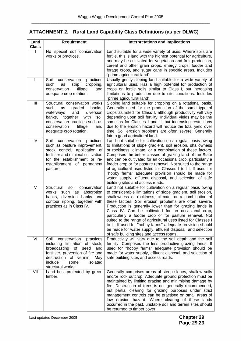
ATTACHMENT 2. Rural Land Capability Class Definitions (as per DLWC)
Land Class
Requirement Interpretations and Implications
I No special soil conservation works or practices.
Land suitable for a wide variety of uses. Where soils are fertile, this is land with the highest potential for agriculture, and may be cultivated for vegetation and fruit production, cereal and other grain crops, energy crops, fodder and forage crops, and sugar cane in specific areas. Includes "prime agricultural land".
II Soil conservation practices such as strip cropping, conservation tillage and adequate crop rotation.
Usually gently sloping land suitable for a wide variety of agricultural uses. Has a high potential for production of crops on fertile soils similar to Class I, but increasing limitations to production due to site conditions. Includes "prime agricultural land".
III Structural conservation works such as graded banks, waterways and diversion banks, together with soil conservation practices such as conservation tillage and adequate crop rotation.
Sloping land suitable for cropping on a rotational basis. Generally used for the production of the same type of crops as listed for Class I, although productivity will vary depending upon soil fertility. Individual yields may be the same as for Classes I and II, but increasing restrictions due to the erosion hazard will reduce the total yield over time. Soil erosion problems are often severe. Generally fair to good agricultural land.
IV Soil conservation practices such as pasture improvement, stock control, application of fertiliser and minimal cultivation for the establishment or re-establishment of permanent pasture.
Land not suitable for cultivation on a regular basis owing to limitations of slope gradient, soil erosion, shallowness or rockiness, climate, or a combination of these factors. Comprises the better classes of grazing land of the State and can be cultivated for an occasional crop, particularly a fodder crop or for pasture renewal. Not suited to the range of agricultural uses listed for Classes I to III. If used for "hobby farms" adequate provision should be made for water supply, effluent disposal, and selection of safe building sites and access roads.
V Structural soil conservation works such as absorption banks, diversion banks and contour ripping, together with practices as in Class IV.
Land not suitable for cultivation on a regular basis owing to considerable limitations of slope gradient, soil erosion, shallowness or rockiness, climate, or a combination of these factors. Soil erosion problems are often severe. Production is generally lower than for grazing lands in Class IV. Can be cultivated for an occasional crop, particularly a fodder crop or for pasture renewal. Not suited to the range of agricultural uses listed for Classes I to Ill. If used for "hobby farms" adequate provision should be made for water supply, effluent disposal, and selection of safe building sites and access roads.
VI Soil conservation practices including limitation of stock, broadcasting of seed and fertiliser, prevention of fire and destruction of vermin. May include some isolated structural works.
Productivity will vary due to the soil depth and the soil fertility. Comprises the less productive grazing lands. If used for "hobby farms" adequate provision should be made for water supply, effluent disposal, and selection of safe building sites and access roads.
VII Land best protected by green timber.
Generally comprises areas of steep slopes, shallow soils and/or rock outcrop. Adequate ground protection must be maintained by limiting grazing and minimising damage by fire. Destruction of trees is not generally recommended, but partial clearing for grazing purposes under strict management controls can be practised on small areas of low erosion hazard. Where clearing of these lands occurred in the past, unstable soil and terrain sites should be returned to timber cover.
Last updated December 2005 Chapter 29 Page 29.23

Wagga Wagga Development Control Plan 2005 _______________________________________________________________________________
VIII Cliffs, lakes or swamps and other lands unsuitable for agricultural and pastoral production.
Land unusable for agricultural or pastoral uses. Recommended uses are those compatible with the preservation of the natural vegetation namely: water supply catchments, wildlife refuges, national and state parks, and scenic areas.
Last updated December 2005 Chapter 29 Page 29.24

Wagga Wagga Development Control Plan 2005 _______________________________________________________________________________
ATTACHMENT 3. Developer Contributions and Assessment Fees (2000/01)
1 Developer Contributions for Establishing New Native Vegetation
Item Contribution
Fencing $1500 per kilometre
Revegetation $1 per seedling
Note: These two figures represent half the estimated cost of those items as outlined in the South West Slopes Revegetation Guide 1998 (page 428).
2 Assessment Costs to Determine Satisfactory Fencing of Existing Native Vegetation
Area Fenced Fees
Up to 6 hectares $80 (Minimum Fee)
Hectares 7 to 10 plus $10 per hectare
Above 10 hectares plus $5 per hectare
3 Assessment Costs to Determine Satisfactory Revegetation Works
Area Planted Fees
Up to 4 hectares $100 (Minimum Fee)
Hectares 5 to 7 plus $20 per hectare
Hectares 8 to 10 plus $10 per hectare
Above 10 hectares plus $5 per hectare
Last updated December 2005 Chapter 29 Page 29.25

Wagga Wagga Development Control Plan 2005 _______________________________________________________________________________
ATTACHMENT 4. Native Vegetation Profiles
Last updated December 2005 Chapter 29 Page 29.26

Wagga Wagga Development Control Plan 2005 _______________________________________________________________________________
Last updated December 2005 Chapter 33 Page 33.27

Wagga Wagga Development Control Plan 2005 _______________________________________________________________________________
Last updated December 2005 Chapter 29 Page 29.28

Wagga Wagga Development Control Plan 2005 _______________________________________________________________________________
Last updated December 2005 Chapter 29 Page 29.29
Wagga Wagga Development Control Plan 2005 _______________________________________________________________________________
Last updated December 2005 Chapter 29 Page 29.30

Wagga Wagga Development Control Plan 2005 _______________________________________________________________________________
Page 29.31
Last updated December 2005 Chapter 29