City of Ballarat Native Vegetation Mapping and Review of ... · PDF fileCity of Ballarat...
22
School of Science & Engineering City of Ballarat Native Vegetation Mapping and Review of the Vegetation Protection Overlay (VPO1) Centre for Environmental Management
Transcript of City of Ballarat Native Vegetation Mapping and Review of ... · PDF fileCity of Ballarat...
School of Science & Engineering
City of Ballarat Native Vegetation Mapping and Review of the Vegetation
Protection Overlay (VPO1)
Centre for Environmental Management
Native Vegetation Mapping and Review of the
Vegetation Protection Overlay (VPO1)
Prepared for the City of Ballarat
By: Centre for Environmental Management University of Ballarat Project Team Robert Milne
Tim D’Ombrain (BEN Biodiversity Services)
Janet Leversha
August 2005
This document may be cited as:
Milne, R., D’Ombrain, T and Leversha, J. (2005). Native Vegetation Mapping and Review of the Vegetation Protection Overlay. Report to City of Ballarat. Centre for Environmental Management, University of Ballarat, Mt. Helen, Victoria.

ii
ACKNOWLEDGEMENTS
The project team would like to acknowledge the City of Ballarat project manager Miriam Semmel and the project steering committee, Melanie Emmett, Govind Maksay, Chris Pitfield, Cr Wayne Rigg, Brenda Rutherford and Craig Whiteford, for providing project support, guidance and feedback. The project team would also like to thank Roger Thomas and Kurtis Noyce for providing valuable information on native vegetation of the region.

iii
CONTENTS
1. INTRODUCTION....................................................................................................................... 1 1.1 Background .......................................................................................................................................1 1.2 Project objectives ..............................................................................................................................2 1.3 Project outputs ..................................................................................................................................2 1.4 Study area.........................................................................................................................................2
2. THE VEGETATION PROTECTION OVERLAY........................................................................ 3 2.1 Vegetation Significance.....................................................................................................................3 2.2 Vegetation Protection Objective........................................................................................................6 2.3 Current extent of the Vegetation Protection Overlay ........................................................................6
3. NATIVE VEGETATION MAPPING ........................................................................................... 8 3.1 Existing vegetation mapping .............................................................................................................8 3.2 Project mapping ................................................................................................................................8 3.3 Significant vegetation and proposed Vegetation Protection Overlay amendments........................11
4. RECOMMENDATIONS........................................................................................................... 15
REFERENCES................................................................................................................................ 16
APPENDIX 1 – SIGNIFICANT VEGETATION CRITERIA.............................................................. 17
Figures Figure 1.1 Location of the project study area..................................................................................................2 Figure 2.1 Current Vegetation Protection Overlay (VPO1) .............................................................................7 Figure 3.1 Native vegetation occurring on private land or roadsides within the study area. ........................10 Figure 3.2 Significant native vegetation and associated land parcels ..........................................................13 Figure 3.3 Proposed Vegetation Protection Overlay 1..................................................................................14
Tables Table 3.1 EVCs occurring within the study area on private land or roadsides. .............................................9 Table 3.2 The area of each bioregional conservation status category occurring within the study
area on private land or roadsides ..................................................................................................9

1
1. INTRODUCTION
1.1 Background The current distribution and status of native vegetation in the Ballarat region is strongly related to the pattern of historical events and landuse. Prior to European occupation the region supported a range of native vegetation types from eucalypt forests and woodlands to treeless grasslands and herbfields. These vegetation types were associated with the various landtypes of the region and were present over virtually all terrestrial environments and some aquatic systems.
The extent of native vegetation of the region has been greatly reduced since the early 1800’s through clearing for agriculture, mining, urban development, forestry, water supply, roads and other human infrastructure. Much of the remaining native vegetation has be modified by disturbances such as changed fire regimes, weed invasion, selective removal of vegetation, altered hydrological processes, grazing by domestic stock, artificial fertilisation and soil disturbance. A large proportion of the remnant vegetation occurring in the City of Ballarat region is located on private land. Remnant vegetation also exists in conservation parks and reserves, state forest, recreation reserves, roadsides, streamside reserves, rail reserves and other public land blocks throughout the City.
Conservation and protection of the remaining native vegetation in the region is a key element of biodiversity conservation and sustainable land use practices. Biodiversity conservation and sustainable land use are recognised by local, state and federal governments as fundamental to the future sustainability of our society. Supported by the National Strategy for the Conservation of Australia’s Biological Diversity (Commonwealth of Australia 1996), the first priority action listed in the Australian Government’s National Objectives and Targets for Biodiversity Conservation 2001–2005 (Environment Australia 2001) is to ‘protect and restore native vegetation and terrestrial ecosystems’. Under the Victorian Government’s Biodiversity Strategy (NRE 1997a, b, c), goals for biodiversity management include “a reversal, across the entire landscape, of the long-term decline in the extent and quality of native vegetation”. Victoria’s Native Vegetation Management – A Framework for Action (DNRE 2002) establishes the strategic direction for the protection, enhancement and revegetation of native vegetation across the State. The Framework identifies the retention and management of remnant native vegetation as the primary method of conserving natural biodiversity.
The Ballarat Region Conservation Strategy (City of Ballarat 1999) includes the protection of native vegetation and maintenance of biodiversity as primary objectives of native vegetation management in the region. Protection of native flora and fauna is listed as a key planning issue relating to the environment in the Municipal Strategic Statement (Clause 21.04-1, 7 April 2005) of the Ballarat Planning Scheme.
The City of Ballarat aims to ensure that all significant native vegetation is protected under the controls of the Ballarat Planning Scheme. The Ballarat Planning Scheme includes a Vegetation Protection Overlay (VPO) as part of the Local Provisions. The VPO is based on the State Planning Policy Framework. The City of Ballarat recognises that the current Vegetation Protection Overlay does not include all areas of significant native vegetation within the municipality. This project was undertaken to identify significant native vegetation within the City of Ballarat and to review the application of the Vegetation Protection Overlay.
INTRODUCTION
2
1.2 Project objectives The primary objectives of this project were;
• Develop selection criteria for the identification of significant vegetation. • Identify and map areas of significant native vegetation on private land within the
urban area of Ballarat and immediate surrounds. • Review the existing VPO1 areas and identify changes or additions to the Overlay.
1.3 Project outputs The outputs of this project are:
• Maps showing areas of identified significant native vegetation. • Documentation of the reasons for the inclusion of the identified areas of significant
vegetation within the Vegetation Protection Overlay. • Recommendations for amendments to the Ballarat Planning Scheme. • A spatial layer (polygons) of the areas of proposed Vegetation Protection Overlay.
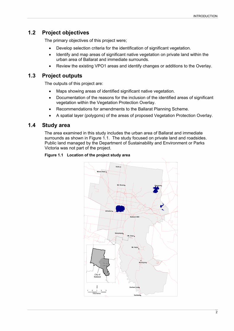
1.4 Study area The area examined in this study includes the urban area of Ballarat and immediate surrounds as shown in Figure 1.1. The study focused on private land and roadsides. Public land managed by the Department of Sustainability and Environment or Parks Victoria was not part of the project. Figure 1.1 Location of the project study area
Miners RestMiners RestMiners RestMiners RestMiners RestMiners RestMiners RestMiners RestMiners Rest
SulkySulkySulkySulkySulkySulkySulkySulkySulky
Mt. RowanMt. RowanMt. RowanMt. RowanMt. RowanMt. RowanMt. RowanMt. RowanMt. Rowan
SebastopolSebastopolSebastopolSebastopolSebastopolSebastopolSebastopolSebastopolSebastopol
AlfredtonAlfredtonAlfredtonAlfredtonAlfredtonAlfredtonAlfredtonAlfredtonAlfredton
Durham LeadDurham LeadDurham LeadDurham LeadDurham LeadDurham LeadDurham LeadDurham LeadDurham Lead
GaribaldiGaribaldiGaribaldiGaribaldiGaribaldiGaribaldiGaribaldiGaribaldiGaribaldi
BuninyongBuninyongBuninyongBuninyongBuninyongBuninyongBuninyongBuninyongBuninyong
Mt. HelenMt. HelenMt. HelenMt. HelenMt. HelenMt. HelenMt. HelenMt. HelenMt. Helen
Ballarat CBDBallarat CBDBallarat CBDBallarat CBDBallarat CBDBallarat CBDBallarat CBDBallarat CBDBallarat CBD
Mt. ClearMt. ClearMt. ClearMt. ClearMt. ClearMt. ClearMt. ClearMt. ClearMt. Clear
GlenparkGlenparkGlenparkGlenparkGlenparkGlenparkGlenparkGlenparkGlenpark
1 0 1 2 3
Kilometres
StudyStudyStudyStudyStudyStudyStudyStudyStudyareaareaareaareaareaareaareaareaarea
City ofCity ofCity ofCity ofCity ofCity ofCity ofCity ofCity ofBallaratBallaratBallaratBallaratBallaratBallaratBallaratBallaratBallarat

3
2. THE VEGETATION PROTECTION OVERLAY
Section 42.02 of the Victorian Planning Provisions provides a statewide framework for the application of Vegetation Protection Overlays (VPO) in local planning schemes. The purpose of the Vegetation Protection Overlay as stated in section 42.02 is:
• To implement the State Planning Policy Framework and the Local Planning Policy Framework, including the Municipal Strategic Statement and local planning policies.
• To protect areas of significant vegetation. • To ensure that development minimises loss of vegetation. • To preserve existing trees and other vegetation. • To recognise vegetation protection areas as locations of special significance,
natural beauty, interest and importance. • To maintain and enhance habitat and habitat corridors for indigenous fauna. • To encourage the regeneration of native vegetation.
Section 42.02-1 also states that a schedule to the VPO must contain:
• A statement of the nature and significance of the vegetation to be protected. • The vegetation protection objective to be achieved.
Section 42.02-2 states that a permit is required to remove, destroy or lop any vegetation specified in a schedule to the VPO.
2.1 Vegetation Significance Native vegetation is considered important because it is one of the major components of the environment that contribute to proper ecosystem function. At a primary level, native vegetation is a component of water, gas and nutrient cycles that provide essential elements for living things. Native vegetation influences the quality of land and water resources and biodiversity. For example it provides food and shelter resources to a wide range of soil, terrestrial and aquatic biota. It also helps prevent and control land degradation by reducing soil erosion and dryland salinity as well as reducing sedimentation, excess nutrient buildup and salinisation of waterways and waterbodies.
The aesthetic and functional values of the landscape are also improved by native vegetation and are valued by the communities living within it. Many people undertake recreational activities within reserves and privately owned land containing native vegetation. Living amongst or near native vegetation is appealing to people because of their interest in natural values and the enjoyment they gain from experiencing plants and animals in their immediate living environment. Native trees and shrubs are also valued for the shade, shelter and privacy they provide.
The significance of remnant native vegetation is defined by a range of biological, social and sometimes economic criteria applied at various scales. A commonly used method for assessing the significance of vegetation is to determine the depletion of a particular vegetation type in relation to its estimated original extent. Vegetation types that have been highly depleted, such as native grassland communities, are considered highly significant. Many of the native plant and animal species associated with such depleted communities are likely to have been lost. This type of assessment can be undertaken at a large scale, such as the national extent of a particular vegetation type, through to a regional or local scale where a vegetation community may be depleted in one region but is still abundant in other regions or locations.

THE VEGETATION PROTECTION OVERLAY
4
Measures of the depletion of native vegetation are commonly combined with an assessment of the threats to the remaining areas to determine the conservation status a particular vegetation type or community. The level of threat is often assessed by determining the proportion of a particular vegetation type that is conserved or protected on land managed for conservation purposes. For example a highly depleted vegetation community may be assigned a low level threatened status if the majority of remaining examples are located on land managed for conservation purposes such as national parks or flora and fauna reserves. Conversely a more abundant vegetation community may be considered at risk if the majority of it’s current extent is on freehold land.
Additional criteria used for defining the significance of vegetation include its value as habitat for animals, particularly rare and threatened species, its role in preventing and controlling land degradation and its function in aquatic systems.
VPO1 vegetation significance criteria Schedule 1 of the current Ballarat Planning Scheme Local Provisions describes the nature and significance of vegetation to be protected under VPO1 as:
• The high level of vegetation cover makes a valuable contribution to the character of the area.
• The vegetation has high habitat value. • The vegetation is valuable in the management of the land including the prevention
of erosion and salinity.
This current statement of significance does not adequately consider all factors that contribute to native vegetation being classified as significant, such as the EVC bioregional conservation status, vegetation quality, presence of rare or threatened plants or animals, or its role of riparian and wetland ecosystems. A further limitation of the current VPO1 is that it only applies to native vegetation with a height over 1 metre (VPO Schedule 1, section 3.0). Some of the most depleted and threatened vegetation communities of the region, such as native grasslands and wetland systems, are therefore not currently protected by the VPO1.
Revised criteria for defining the significance of native vegetation covered by a VPO are shown in Appendix 1. The first stage of the process involves classifying vegetation as either a native remnant, native revegetation or as non native. If the vegetation is classified as a native remnant then it is assessed against six significance criteria outlined below:
1. Vegetation community/class conservation status. The Department of Sustainability and Environment has developed criteria for assessing the bioregional conservation status (BCS) of EVCs within Victoria (DNRE 2002). This assessment is based on a refinement of biodiversity criteria developed by Commonwealth and State agencies as part of the Regional Forest Agreement Process. The criteria include assessments of depletion, degradation, current threats and rarity to classify EVCs as presumed extinct, endangered, vulnerable, depleted, rare or of least concern. The bioregional conservation status is used to determine the conservation significance of vegetation under Victoria’s native vegetation management framework (DNRE 2002). Vegetation communities or ecosystems may also be listed as threatened under the Commonwealth’s Environmental Protection and Biodiversity Conservation Act 1999 (EPBC Act) or Victoria’s Flora and Fauna Guarantee Act 1988 (FFG Act).
2. Rare or threatened flora or fauna. Protection of rare or threatened plants and animals reduces the rate of species extinction and helps conserve biodiversity. Rare and threatened plants and animals
THE VEGETATION PROTECTION OVERLAY
5
are protected under a variety of National and State legislation and policy. Rare or threatened plant and animal species and their conservation status are listed under the Commonwealth’s EPBC Act, the State’s FFG Act, and the Department of Sustainability and Environment’s Advisory Lists of Rare or Threatened Plants and Vertebrate Fauna. Plants and animals listed under EPBC Act are classified as extinct, critically endangered, endangered or vulnerable. Species listed under the FFG Act are considered threatened in Victoria. Plants and animals listed under the DSE List of Rare or Threatened Plants and Vertebrate Fauna may be classified as presumed extinct in Victoria, endangered in Victoria, vulnerable in Victoria, rare in Victoria or poorly known in Victoria.
3. Fauna habitat Native vegetation remnants may be significant because they provide habitat for significant native fauna. These remnants may provide a combination of food, shelter and protection from predators for threatened animals. Protection of habitat is one of the most important management options for conserving threatened fauna.
4. Riparian and wetland ecosystems Native vegetation is an integral component of riparian ecosystems providing habitat for fauna associated with waterways and waterbodies. Native vegetation also stabilises river and stream banks, reducing soil erosion and associated sedimentation of waterways. It also helps reduce excess nitrification of waterways. High levels of nutrients in water bodies can lead to undesirable algal blooms and facilitate weed invasion.
5. Landscape function Native vegetation plays an important role in the function and health of ecosystems at the regional, state, national and global scales. Native vegetation is an integral component of air, water, soil and climatic systems. Examples of landscape functions performed by native vegetation include:
• Corridors and linkages between remnant patches. • Prevention and control of soil erosion. • Prevention and control of salinity. • Nutrient cycling. • Carbon sinks.
6. Vegetation condition High quality remnants of native vegetation are valuable because they are the most complete examples of ecosystems that were present prior to European occupation. These remnants are more likely to contain the range of expected plant lifeforms for a particular vegetation community (e.g. trees, shrubs, perennial grasses), support the highest species richness and provide quality habitat for fauna. The biodiversity value of these remnants is therefore high. The condition of high quality remnants is generally indicative of relatively low levels of human disturbance and related impacts.
Native vegetation that satisfies one or more of the above mentioned criteria is classified as significant and qualifies for protection under the VPO1. The criteria are presented in no particular order and are considered of equal importance. These criteria have been used to classify the significance of native vegetation mapped in this project (see section 3.3).
Predominately revegetated areas are not assessed against the native remnant criteria and do not qualify to be covered under the VPO1. It may be more appropriate to develop a separate VP0 category for such areas of native vegetation (see section 4). Vegetation that is determined to be non-native, also does not qualify to be covered by the VPO1.

THE VEGETATION PROTECTION OVERLAY
6
2.2 Vegetation Protection Objective The vegetation protection objective to be achieved via the VPO1 is currently stated in schedule 1 of the Ballarat Planning Scheme Local Provisions as:
• Protection of vegetation within areas which are characterised by extensive tree cover.
• Protection of vegetation which has habitat value. • Protection of vegetation which has land management value and ensuring that where
existing vegetation is removed replacement planting takes place where required to address existing or prevent future land management problems.
The current objectives should be modified and extended to incorporate additional reasons for protection of areas under the VPO1. The objectives should aim to protect or enhance the values identified in the significance criteria described in section 2.1. The following objectives are proposed:
• Protection of threatened Ecological Vegetation Classes and regionally significant vegetation communities within the City of Ballarat.
• Protection of populations of rare or threatened flora or fauna and regionally significant species within the City of Ballarat.
• Prevent removal or degradation of rare or threatened and regionally significant fauna habitat.
• Protect instream and fringing vegetation associated with riparian and wetland ecosystems to prevent loss of fauna habitat, water quality decline, bank erosion, sedimentation and loss of riparian and wetland vegetation.
• Protect native vegetation that contributes to landscape function through provision of connectivity between remnants, prevention and control of salinity and soil erosion, and maintenance of natural hydrological regimes.
2.3 Current extent of the Vegetation Protection Overlay The coverage of the current VPO1 for the City of Ballarat is shown in Figure 2.1. The extent of the current VPO1 is limited to Buninyong, Mt Helen, Invermay, Nerrina, and Durham Lead areas. The total area covered by the current VPO1 is 2,901.5 ha.
It is recognised that many areas of significant native vegetation within the study area are not covered by the current VPO1. For example, potentially significant vegetation not covered by the current VPO1 occurs on private land surrounding the Creswick State Forest, the Canadian State Forest, Union Jack Reserve and areas of public land in the Durham Lead and Garibaldi areas. Significant native vegetation on private land also occurs in the Napoleans, Magpie, Mt Helen, Ballarat East and Glenpark regions.

THE VEGETATION PROTECTION OVERLAY
7
Figure 2.1 Current Vegetation Protection Overlay (VPO1)
VPO1
Study area
Main roads

8
3. NATIVE VEGETATION MAPPING
3.1 Existing vegetation mapping Vegetation mapping has been previously undertaken within the study area at various scales and for a range of purposes. The following maps were obtained for this project in digital format.
• Vegetation has been mapped on a statewide basis by the Department of Sustainability and Environment (DSE) at a scale of 1:100,000. Vegetation has been identified and classified into Ecological Vegetation Classes (EVCs) using a combination of techniques including aerial photo interpretation, satellite image interpretation and field survey. DSE has also modeled the presumed statewide distribution of Ecological Vegetation Classes at 1750.
• Significant roadsides and remnant vegetation within the City of Ballarat mapped by DSE.
• The Australian Koala Foundation has undertaken vegetation mapping within the City of Ballarat region. Native tree cover was mapped and classified according to the type and proportion of tree species present.
• Roadside native vegetation assessments by the LINCS project. Individually, none of the above layers were directly suitable for development of the revised VPO1. These layers were, however, used to augment and guide the mapping undertaken for this project.
3.2 Project mapping Mapping was undertaken for this project to refine, extend and improve information on the extent, type and potential significance of native vegetation occurring on private land and roadsides within the study area. Digital aerial photograph interpretation (API) was the primary method used to map vegetation for this project. Manual digitising of native vegetation polygons at a scale of 1:5000 was undertaken in a GIS environment using high resolution digital aerial photographs provided by the City of Ballarat. Existing vegetation mapping layers, including the AKF koala habitat map and extant EVCs, were used as references where necessary. Roadside vegetation was mapped using the aerial photographs and the existing LINCS roadside vegetation assessments.
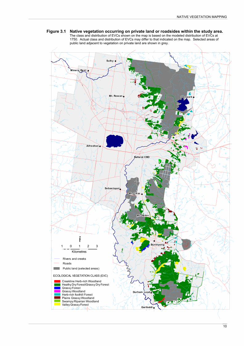
Approximately 3,693 ha of native vegetation on private land and roadsides were identified and mapped. The resulting layer was then overlayed with the Pre-1750 EVC map layer to classify the identified native vegetation into EVCs. The distribution and classification of the mapped native vegetation is shown in Figure 3.1. It is acknowledged that API is limited in its ability to identify non-treed native vegetation such as grassland or wetland communities. It is possible, therefore, that some remnants of these communities have not been identified by this project. Where feasible, known grassland or wetland remnants have been identified by consulting local native vegetation experts and have been added to the vegetation map.
The type, area and bioregional conservation status of EVCs identified within the study area are shown in Table 3.1. Table 3.2 shows the area of each bioregional conservation status category occurring within the study area on private land or roadsides. It must be noted that the Pre 1750 EVC layer is a modeled distribution of vegetation type and has been used in this project as preliminary guide to the distribution of EVCs within the study area. On the ground, EVC boundaries will be more complex and each area is likely to support more EVCs than those shown by the map. More intensive aerial photograph

NATIVE VEGETATION MAPPING
9
interpretation and systematic ground truthing is required to confirm the classification and boundaries of EVCs within the study area. These tasks are beyond the scope of this study.
The Heathy Dry Forest and Grassy Dry Forest EVCs have been combined into a single unit for this project as they often occur together as a complex or mosaic throughout the study area. These EVCs grade into one class or the other depending on site characteristics such as soil type, aspect and soil moisture. Additionally gullys and valleys within the Heathy Dry Forest/Grassy Dry Forest unit commonly support other EVCs. For example, Creekline Herb-rich Woodland may occur in wetter areas of the drainage lines while Valley Grassy Forest may fringe the adjacent bank or slope. The current EVC mapping is not at a sufficient scale and accuracy to show clear separation of these and other discretely distributed EVCs. Table 3.1 EVCs occurring within the study area on private land or roadsides.
EVC code EVC name Bioregional Conservation Status1
Area (ha)2
20/22 Heathy Dry Forest/ Grassy Dry Forest
Least concern/Depleted 3294
47 Valley Grassy Forest Vulnerable 203
55 Plains Grassy Woodland Endangered 83
23 Herb-rich Foothill Forest Vulnerable 50
128 Grassy Forest Vulnerable 22
175 Grassy Woodland Endangered 17
164 Creekline Herb-rich Woodland
Vulnerable 15
83 Swampy Riparian Woodland
Endangered 6
1 Department of Sustainability and Environment bioregional conservation assessment of EVCs (DSE 2005). 2 Approximate area based on mapping of existing vegetation undertaken for this project overlayed with the DSE pre-1750 Ecological Vegetation Class layer to estimate distribution of vegetation types.
Table 3.2 The area of each bioregional conservation status category occurring within the study area on private land or roadsides
EVC Bioregional Conservation Status1 Area (ha) Endangered 106
Vulnerable 290
Depleted/Least Concern 3294 1 Department of Sustainability and Environment bioregional conservation assessment of EVCs (DSE 2005)
NATIVE VEGETATION MAPPING
10
Figure 3.1 Native vegetation occurring on private land or roadsides within the study area. The class and distribution of EVCs shown on the map is based on the modeled distribution of EVCs at 1750. Actual class and distribution of EVCs may differ to that indicated on the map. Selected areas of public land adjacent to vegetation on private land are shown in grey.
Miners RestMiners RestMiners RestMiners RestMiners RestMiners RestMiners RestMiners RestMiners Rest
SulkySulkySulkySulkySulkySulkySulkySulkySulky
Mt. Row anMt. Row anMt. Row anMt. Row anMt. Row anMt. Row anMt. Row anMt. Row anMt. Row an
SebastopolSebastopolSebastopolSebastopolSebastopolSebastopolSebastopolSebastopolSebastopol
AlfredtonAlfredtonAlfredtonAlfredtonAlfredtonAlfredtonAlfredtonAlfredtonAlfredton
Durham LeadDurham LeadDurham LeadDurham LeadDurham LeadDurham LeadDurham LeadDurham LeadDurham Lead
GaribaldiGaribaldiGaribaldiGaribaldiGaribaldiGaribaldiGaribaldiGaribaldiGaribaldi
BuninyongBuninyongBuninyongBuninyongBuninyongBuninyongBuninyongBuninyongBuninyong
Mt. HelenMt. HelenMt. HelenMt. HelenMt. HelenMt. HelenMt. HelenMt. HelenMt. Helen
Ballarat CBDBallarat CBDBallarat CBDBallarat CBDBallarat CBDBallarat CBDBallarat CBDBallarat CBDBallarat CBD
Mt. ClearMt. ClearMt. ClearMt. ClearMt. ClearMt. ClearMt. ClearMt. ClearMt. Clear
GlenparkGlenparkGlenparkGlenparkGlenparkGlenparkGlenparkGlenparkGlenpark
1 0 1 2 3
Creekline Herb-rich WoodlandHeathy Dry Forest/Grassy Dry ForestGrassy ForestGrassy WoodlandHerb-rich foothill ForestPlains Grassy WoodlandSwampy Riparian WoodlandValley Grassy Forest
ECOLOGICAL VEGETATION CLASS (EVC)
Kilometres
Public land (selected areas)
RoadsRivers and creeks

NATIVE VEGETATION MAPPING
11
Virtually all the mapped native vegetation occurs in the eastern half of the study area and extends from the northern areas surrounding the Creswick State Forest and Creswick Regional Park south to Durham Lead and Garibaldi. Much of the remaining native vegetation in this area has regenerated following extensive clearing for mining and related activities in the 1800s.
Most public land areas supporting native vegetation within the study area, such as Creswick Regional Park, Creswick State Forest, Canadian State Forest, Union Jack Reserve, Mount Buninyong and Crown land in the Durham Lead area, are surrounded by patches of remnant native vegetation on private land. Remnants abutting public land are particularly important because they increase the overall size of remnant vegetation in an area, improve connectivity between blocks and form buffers against disturbances from activities on private land. Similarly the presence of native vegetation on adjacent public land enhances the conservation value of remnants on private land.
With the exception of some roadside vegetation, very few areas of remnant native vegetation remain in the west of the study area. This reflects past and current land use in these areas. Higher soil fertility in the west has led to more extensive clearing for agriculture. The eastern section of the study area is dominated by older and less productive soil types that are less suited to agriculture.
Very little remnant native vegetation remains in the more established and densely populated areas of Ballarat. Most public parks and reserves in this area contain non-native plants. However, much of the mapped native vegetation within the study area occurs within medium density residential and semi-rural areas.
3.3 Significant vegetation and proposed Vegetation Protection Overlay amendments The native vegetation map layer produced by this project was classified using the significance criteria specified in section 2.1. Native vegetation classified as significant was determined eligible for inclusion in the updated VPO1 coverage. All areas of mapped native vegetation were classified as significant as they satisfied Criteria 1 (EVC conservation status). All the mapped native vegetation includes EVCs that have a bioregional conservation status of endangered, vulnerable or depleted. While Heathy Dry Forest, a common component of the vegetation of the study area, is classified as Least Concern, most occurrences of this EVC include patches of Grassy Dry Forest which is classified as depleted in the bioregion.
Heathy Dry Forest was combined with Grassy Dry Forest for this project due to mapping limitations. The combined Heathy Dry Forest/Grassy Dry Forest mapping unit, therefore, has been assigned the higher conservation status of depleted as a precautionary measure. Clarification of the distribution of Heathy Dry Forest, Grassy Dry Forest and other EVCs can either be achieved by more detailed mapping of the study area or by individual site assessments undertaken for planning permit applications.
Similarly, the precautionary principal had been applied to the other significance criteria including presence of threatened species, fauna habitat quality, presence of riparian and wetland vegetation, landscape function and vegetation quality. Where available information confirmed the presence of these criteria, vegetation was classified as significant. Where there was limited information on the characteristics of a remnant it could not be assumed that significant values were not present. In this case it is assumed that a remnant could contain significant values and therefore qualifies for inclusion in the VPO1. More detailed assessments of sites should be undertaken on a case by case situation to evaluate the values present within a particular remnant. Such assessments would provide the necessary information to evaluate the site against the vegetation significance criteria as part of the planning permit application process. Once the

NATIVE VEGETATION MAPPING
12
vegetation significance classification is clarified a decision can be made on whether a planning permit should be granted or refused.
The significant vegetation layer derived from the vegetation mapping was overlayed with the most recent cadastral layer to identify land parcels supporting significant vegetation. Significant vegetation and corresponding land parcels are shown in Figure 3.2. Crown land parcels supporting native vegetation and not managed by Parks Victoria or the Department of Sustainability primarily as conservation reserves were also identified. These parcels were combined with the parcels supporting significant vegetation to produce the proposed amended VPO1 layer shown in Figure 3.3. The proposed VPO1 covers approximately 10,519 ha.
It is recognised that the proposed VPO1 includes property parcels that are only partially covered with native vegetation. In such cases a planning permit application is still required to fully assess the native vegetation values in relation to a proposed development.

NATIVE VEGETATION MAPPING
13
Figure 3.2 Significant native vegetation and associated land parcels
Miners RestMiners RestMiners RestMiners RestMiners RestMiners RestMiners RestMiners RestMiners Rest
SulkySulkySulkySulkySulkySulkySulkySulkySulky
Mt. Row anMt. Row anMt. Row anMt. Row anMt. Row anMt. Row anMt. Row anMt. Row anMt. Row an
SebastopolSebastopolSebastopolSebastopolSebastopolSebastopolSebastopolSebastopolSebastopol
AlfredtonAlfredtonAlfredtonAlfredtonAlfredtonAlfredtonAlfredtonAlfredtonAlfredton
Durham LeadDurham LeadDurham LeadDurham LeadDurham LeadDurham LeadDurham LeadDurham LeadDurham Lead
GaribaldiGaribaldiGaribaldiGaribaldiGaribaldiGaribaldiGaribaldiGaribaldiGaribaldi
BuninyongBuninyongBuninyongBuninyongBuninyongBuninyongBuninyongBuninyongBuninyong
Mt. HelenMt. HelenMt. HelenMt. HelenMt. HelenMt. HelenMt. HelenMt. HelenMt. Helen
Ballarat CBDBallarat CBDBallarat CBDBallarat CBDBallarat CBDBallarat CBDBallarat CBDBallarat CBDBallarat CBD
Mt. ClearMt. ClearMt. ClearMt. ClearMt. ClearMt. ClearMt. ClearMt. ClearMt. Clear
GlenparkGlenparkGlenparkGlenparkGlenparkGlenparkGlenparkGlenparkGlenpark
1 0 1 2 3
Kilometres
Land parcel boundary
Signficant vegetation

NATIVE VEGETATION MAPPING
14
Figure 3.3 Proposed Vegetation Protection Overlay 1
Miners RestMiners RestMiners RestMiners RestMiners RestMiners RestMiners RestMiners RestMiners Rest
SulkySulkySulkySulkySulkySulkySulkySulkySulky
Mt. Row anMt. Row anMt. Row anMt. Row anMt. Row anMt. Row anMt. Row anMt. Row anMt. Row an
SebastopolSebastopolSebastopolSebastopolSebastopolSebastopolSebastopolSebastopolSebastopol
AlfredtonAlfredtonAlfredtonAlfredtonAlfredtonAlfredtonAlfredtonAlfredtonAlfredton
Durham LeadDurham LeadDurham LeadDurham LeadDurham LeadDurham LeadDurham LeadDurham LeadDurham Lead
GaribaldiGaribaldiGaribaldiGaribaldiGaribaldiGaribaldiGaribaldiGaribaldiGaribaldi
BuninyongBuninyongBuninyongBuninyongBuninyongBuninyongBuninyongBuninyongBuninyong
Mt. HelenMt. HelenMt. HelenMt. HelenMt. HelenMt. HelenMt. HelenMt. HelenMt. Helen
Ballarat CBDBallarat CBDBallarat CBDBallarat CBDBallarat CBDBallarat CBDBallarat CBDBallarat CBDBallarat CBD
Mt. ClearMt. ClearMt. ClearMt. ClearMt. ClearMt. ClearMt. ClearMt. ClearMt. Clear
GlenparkGlenparkGlenparkGlenparkGlenparkGlenparkGlenparkGlenparkGlenpark
1 0 1 2 3
Kilometres
Proposed VPO1Current VPO1
15
4. RECOMMENDATIONS
• Update VPO1 schedule to include the revised statement of vegetation significance (see section 2.1).
• Update VPO1 schedule to include revised vegetation protection objectives (see section 2.2).
• Develop an information package for applicants including background information on native vegetation of the region, description of the VPO1 including statements of significance and objectives, and permit application guidelines including a description of the information required from the applicant. The information kit, Native Vegetation Conservation in the City of Ballarat (Schembri 2004), could be revised and expanded as part of the information package.
• Use the vegetation significance criteria for determining the type and significance of native vegetation as part of the assessment of planning permit applications relating to the VPO1.
• Develop a system for tracking and storing information from site vegetation assessments undertaken for planning permit applications under the VPO1 and any resulting conditions associated with granted permits. The system could also be used to store information on habitat hectare assessments and any vegetation planting or protection offsets required due to clearance of native vegetation on a site in accordance with the State Government’s Native Vegetation Framework.
• Develop a map layer of revegetation works and offset plantings within the City of Ballarat using existing mapping and databases, and new mapping as required. This would include revegetation works funded under Local, State and Commonwealth initiatives. It is suggested that this be undertaken in partnership with Catchment Management Authorities, being the primary agency for facilitating revegetation projects, and the Department of Sustainability and Environment as the agency responsible for the Native Vegetation Framework and the associated vegetation removal offset process.
• Develop a new VPO category for the protection of revegetation works (with a focus on those works funded by Local Government, State and Commonwealth funds) and offset plantings resulting from clearance of native vegetation.
• Periodically update the native vegetation map with information on the location, class and significance of native vegetation from planning permit applications and other relevant site assessments.

16
REFERENCES
City of Ballarat (1999). Ballarat Region Conservation Strategy: A Strategy for Sustainable Living. City of Ballarat, Ballarat, Victoria.
Commonwealth of Australia (1996). The National Strategy for the Conservation of Australia's Biological Diversity. Commonwealth Department of the Environment, Sport and Territories.
DNRE (2002). Victoria's Native Vegetation Management: A Framework for Action. Department of Natural Resources and Environment, Victoria.
DSE (2005). Ecological Vegetation Classes (EVC) Benchmarks. Retrieved 2 May, 2005, from ttp://www.dse.vic.gov.au/dse/nrence.nsf/LinkView/43FE7DF24A1447D9CA256EE6007EA8788062D358172E420C4A256DEA0012F71C.
Environment Australia (2001). National Objectives and Targets for Biodiversity Conservation 2001-2005. Environment Australia, Canberra.
NRE (1997a). Victoria's Biodiversity: Directions in Management. Department of Natural Resources and Environment, East Melbourne.
NRE (1997b). Victoria's Biodiversity: Our Living Wealth. Department of Natural Resources and Environment, East Melbourne.
NRE (1997c). Victoria's Biodiversity: Sustaining Our Living Wealth. Department of Natural Resources and Environment, East Melbourne.
Schembri, P. (2004). Native Vegetation Conservation in the City of Ballarat: Information Kit. Report produced for the City of Ballarat.

17
APPENDIX 1 – SIGNIFICANT VEGETATION CRITERIA
Is the vegetation a native remnant or native regrowth?
> 10 % of native understorey (shrubs and/or ground layer) plants present, and/or Mature (capable of recruitment) indigenous trees present
Is the vegetation a rare or threatened EVC1 in the
bioregion?
Vegetation classified as Significant
Vegetation
qualifies for VPO1
Are rare, threatened or regionally significant flora or
fauna species present2?
Is the vegetation part of a riparian or wetland
ecosystem4?
Vegetation does not qualify for VPO1
State wide EVC Bioregional Conservation Status of: • Endangered • Vulnerable • Depleted • Rare
Nationally rare or threatened flora listed under the EPBC Act 1999 as:
• Critically endangered • Endangered • Vulnerable
Victorian rare or threatened flora & fauna (DSE 2003) listed as:
• Endangered • Vulnerable • Rare • Poorly known
Flora and fauna listed under part 3 of the FFG Act 1988 as:
• Threatened • Nominated for listing as threatened
Species listed on regionally significant flora and fauna lists.
Does the vegetation contribute to landscape
function5?
Is the vegetation potential habitat3 for regionally, state and/or nationally significant
fauna?
Components of landscape function include: • Corridors and linkages between other areas of
native vegetation. • Prevention and control of soil erosion • Prevention and control of salinity. • Visual amenity and landscape character values
Native vegetation is an integral component of riparian ecosystems providing habitat for fauna associated with waterways and waterbodies. Native vegetation stabilises river and stream banks, reducing soil erosion and associated sedimentation of waterways.
Is the vegetation a high quality remnant6?
High quality native vegetation is characterised by a combination of:
• Presence of all or most of the expected life forms.
• Low weed cover. • Wide range of habitat features (eg logs, litter,
hollows). • Old trees (if trees present)
Vegetation not classified as Significant
Vegetation does not qualify for VPO1
NO
NO
NO
NO
NO
NO
Is the vegetation native revegetation?
Native vegetation planted for one or more of the following purposes:
• Wind protection • Fauna habitat • Biodiversity gains • Wetland and riparian
ecosystem enhancement • Erosion control • Salinity control • Visual amenity
YES
NO NO
See protection of revegetation
recommendations (Section 4)
YES
YES
YES
YES
YES
YES
YES

18
Footnotes to significance criteria (Appendix 1)
1. Ecological Vegetation Class Bioregional Conservation Status as determined by the Department of Sustainability and Environment. The Bioregional Conservation Status of EVCs occurring in the study area is specified in the GIS layer EVC_BCS100.
2. Rare, threatened or regionally significant species presence may be indicated by records from the Flora Information System (DSE) or the Atlas of Victorian Wildlife (DSE) or by records from a qualified botanist, zoologist or environmental scientist. Regionally significant flora defined as:
Species that meet one or more of the following criteria: 1. The population is an outlier of a species at the edge of its geographical range (i.e.
uncommon in the region but possibly more common in an adjacent region with more suitable conditions) and is present in small numbers (total known population in region <10,000 plants)
2. The plant has been recorded at less than six separate sites across the region (sites within the same Wild Plants of the Ballarat Area 10km2 grid are taken as being one site) and/or the occurrences of the species in the region would cover less than 10km2 in total area
3. The species is not represented in any regional, state or national parks or other secure reserve and/or the occurrences of the species in the region would cover less than 10km2 in total area
4. The form of the species in the region exhibits a high degree of local variation (i.e. a distinct form)
Note any plant of national or state significance listing found in the region overrides the above regional significance criteria
3. Potential habitat may be EVCs identified as suitable for supporting significant fauna. Suitable EVCs may be identified in published literature or be known to support significant fauna populations within other parts of the region.
4. Wetland or riparian vegetation may include areas classified as supporting EVCs with wetland or riparian characteristics.
5. Information from existing landscape studies, LCC reports, CMA priority areas, urban character studies, existing mapping of salinity and erosion.
6. High quality remnant vegetation is defined as vegetation that closely matches the EVC benchmark specified by the Department of Sustainability and Environment.