2500’ Mandatory Setback from Oil and Gas Development · 2500’ Mandatory Setback from Oil and...
20
Colorado Oil & Gas Conservation Commission 2500’ Mandatory Setback from Oil and Gas Development GIS-based assessment of impact proposed 2016 Colorado ballot initiative #78 would have on surface lands available for new oil and gas development facilities or hydraulic fracturing operations. 5/27/2016
Transcript of 2500’ Mandatory Setback from Oil and Gas Development · 2500’ Mandatory Setback from Oil and...

Colorado Oil & Gas Conservation Commission
2500’ Mandatory Setback from Oil and Gas Development GIS-based assessment of impact proposed 2016 Colorado ballot initiative #78 would have on surface lands available for new oil and gas development facilities or hydraulic fracturing operations.
5/27/2016
2
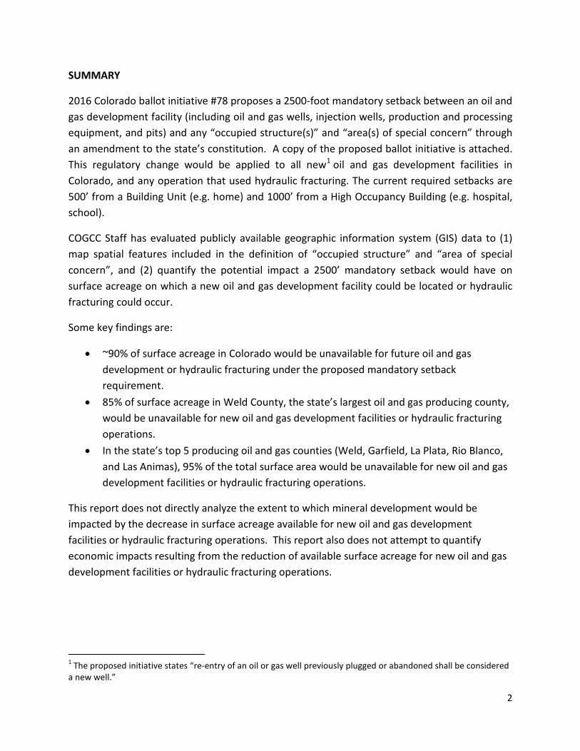
SUMMARY
2016 Colorado ballot initiative #78 proposes a 2500-foot mandatory setback between an oil and gas development facility (including oil and gas wells, injection wells, production and processing equipment, and pits) and any “occupied structure(s)” and “area(s) of special concern” through an amendment to the state’s constitution. A copy of the proposed ballot initiative is attached. This regulatory change would be applied to all new1 oil and gas development facilities in Colorado, and any operation that used hydraulic fracturing. The current required setbacks are 500’ from a Building Unit (e.g. home) and 1000’ from a High Occupancy Building (e.g. hospital, school).
COGCC Staff has evaluated publicly available geographic information system (GIS) data to (1) map spatial features included in the definition of “occupied structure” and “area of special concern”, and (2) quantify the potential impact a 2500’ mandatory setback would have on surface acreage on which a new oil and gas development facility could be located or hydraulic fracturing could occur.
Some key findings are:
• ~90% of surface acreage in Colorado would be unavailable for future oil and gas development or hydraulic fracturing under the proposed mandatory setback requirement.
• 85% of surface acreage in Weld County, the state’s largest oil and gas producing county, would be unavailable for new oil and gas development facilities or hydraulic fracturing operations.
• In the state’s top 5 producing oil and gas counties (Weld, Garfield, La Plata, Rio Blanco, and Las Animas), 95% of the total surface area would be unavailable for new oil and gas development facilities or hydraulic fracturing operations.
This report does not directly analyze the extent to which mineral development would be impacted by the decrease in surface acreage available for new oil and gas development facilities or hydraulic fracturing operations. This report also does not attempt to quantify economic impacts resulting from the reduction of available surface acreage for new oil and gas development facilities or hydraulic fracturing operations.
1 The proposed initiative states “re-entry of an oil or gas well previously plugged or abandoned shall be considered a new well.”
3
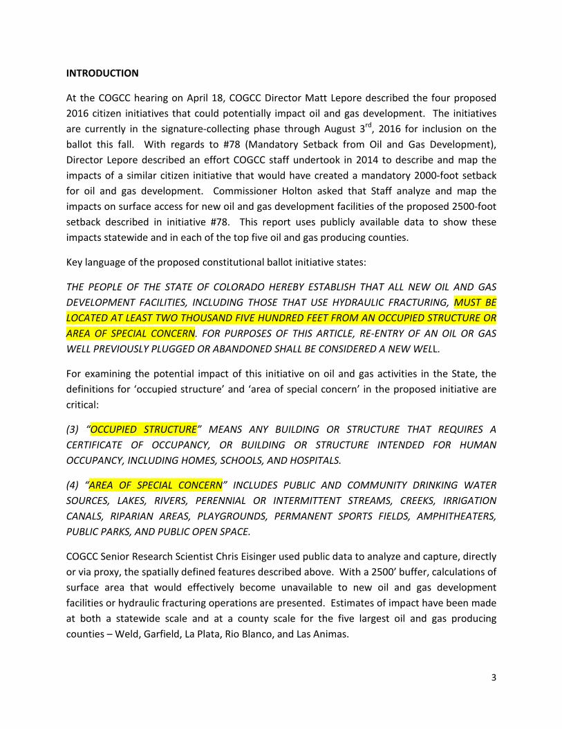
INTRODUCTION
At the COGCC hearing on April 18, COGCC Director Matt Lepore described the four proposed 2016 citizen initiatives that could potentially impact oil and gas development. The initiatives are currently in the signature-collecting phase through August 3rd, 2016 for inclusion on the ballot this fall. With regards to #78 (Mandatory Setback from Oil and Gas Development), Director Lepore described an effort COGCC staff undertook in 2014 to describe and map the impacts of a similar citizen initiative that would have created a mandatory 2000-foot setback for oil and gas development. Commissioner Holton asked that Staff analyze and map the impacts on surface access for new oil and gas development facilities of the proposed 2500-foot setback described in initiative #78. This report uses publicly available data to show these impacts statewide and in each of the top five oil and gas producing counties.
Key language of the proposed constitutional ballot initiative states:
THE PEOPLE OF THE STATE OF COLORADO HEREBY ESTABLISH THAT ALL NEW OIL AND GAS DEVELOPMENT FACILITIES, INCLUDING THOSE THAT USE HYDRAULIC FRACTURING, MUST BE LOCATED AT LEAST TWO THOUSAND FIVE HUNDRED FEET FROM AN OCCUPIED STRUCTURE OR AREA OF SPECIAL CONCERN. FOR PURPOSES OF THIS ARTICLE, RE-ENTRY OF AN OIL OR GAS WELL PREVIOUSLY PLUGGED OR ABANDONED SHALL BE CONSIDERED A NEW WELL.
For examining the potential impact of this initiative on oil and gas activities in the State, the definitions for ‘occupied structure’ and ‘area of special concern’ in the proposed initiative are critical:
(3) “OCCUPIED STRUCTURE” MEANS ANY BUILDING OR STRUCTURE THAT REQUIRES A CERTIFICATE OF OCCUPANCY, OR BUILDING OR STRUCTURE INTENDED FOR HUMAN OCCUPANCY, INCLUDING HOMES, SCHOOLS, AND HOSPITALS.
(4) “AREA OF SPECIAL CONCERN” INCLUDES PUBLIC AND COMMUNITY DRINKING WATER SOURCES, LAKES, RIVERS, PERENNIAL OR INTERMITTENT STREAMS, CREEKS, IRRIGATION CANALS, RIPARIAN AREAS, PLAYGROUNDS, PERMANENT SPORTS FIELDS, AMPHITHEATERS, PUBLIC PARKS, AND PUBLIC OPEN SPACE.
COGCC Senior Research Scientist Chris Eisinger used public data to analyze and capture, directly or via proxy, the spatially defined features described above. With a 2500’ buffer, calculations of surface area that would effectively become unavailable to new oil and gas development facilities or hydraulic fracturing operations are presented. Estimates of impact have been made at both a statewide scale and at a county scale for the five largest oil and gas producing counties – Weld, Garfield, La Plata, Rio Blanco, and Las Animas.
4
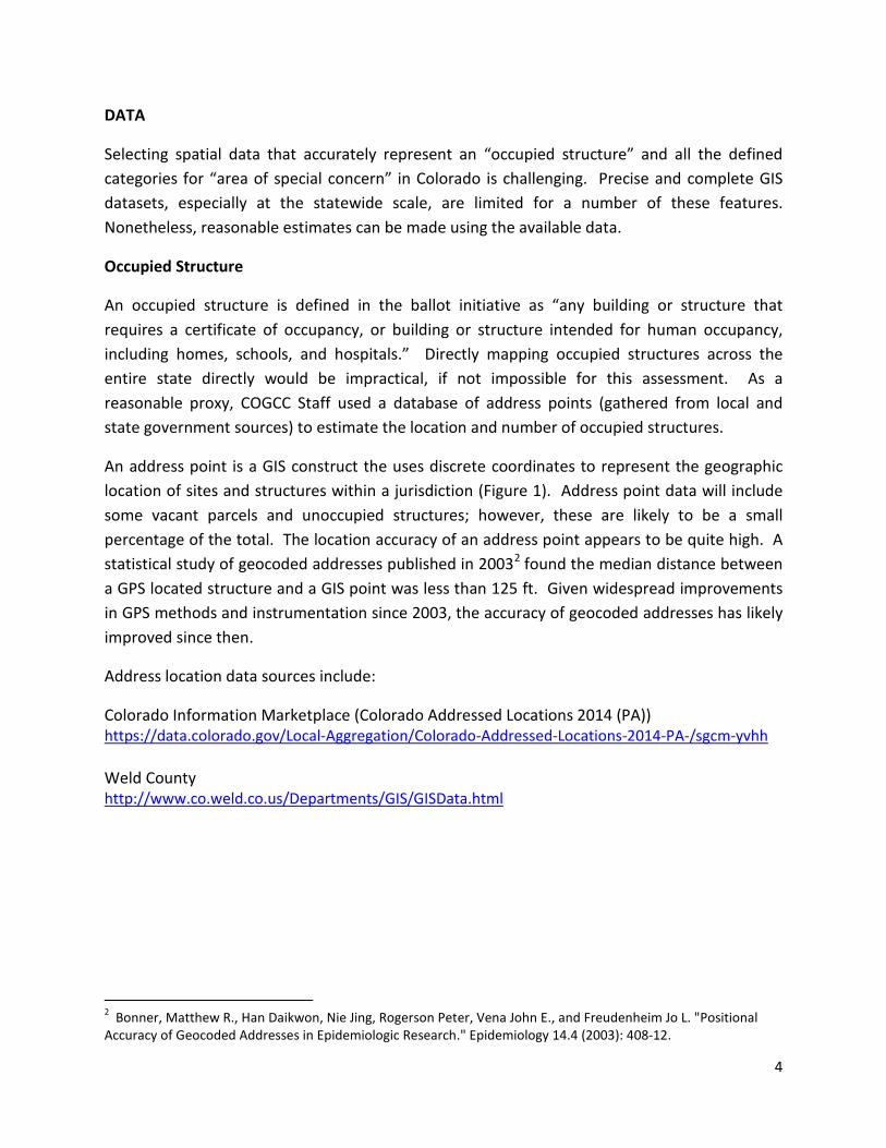
DATA
Selecting spatial data that accurately represent an “occupied structure” and all the defined categories for “area of special concern” in Colorado is challenging. Precise and complete GIS datasets, especially at the statewide scale, are limited for a number of these features. Nonetheless, reasonable estimates can be made using the available data.
Occupied Structure
An occupied structure is defined in the ballot initiative as “any building or structure that requires a certificate of occupancy, or building or structure intended for human occupancy, including homes, schools, and hospitals.” Directly mapping occupied structures across the entire state directly would be impractical, if not impossible for this assessment. As a reasonable proxy, COGCC Staff used a database of address points (gathered from local and state government sources) to estimate the location and number of occupied structures.
An address point is a GIS construct the uses discrete coordinates to represent the geographic location of sites and structures within a jurisdiction (Figure 1). Address point data will include some vacant parcels and unoccupied structures; however, these are likely to be a small percentage of the total. The location accuracy of an address point appears to be quite high. A statistical study of geocoded addresses published in 20032 found the median distance between a GPS located structure and a GIS point was less than 125 ft. Given widespread improvements in GPS methods and instrumentation since 2003, the accuracy of geocoded addresses has likely improved since then.
Address location data sources include:
Colorado Information Marketplace (Colorado Addressed Locations 2014 (PA)) https://data.colorado.gov/Local-Aggregation/Colorado-Addressed-Locations-2014-PA-/sgcm-yvhh Weld County http://www.co.weld.co.us/Departments/GIS/GISData.html
2 Bonner, Matthew R., Han Daikwon, Nie Jing, Rogerson Peter, Vena John E., and Freudenheim Jo L. "Positional Accuracy of Geocoded Addresses in Epidemiologic Research." Epidemiology 14.4 (2003): 408-12.

5
Figure 1 – Example of Weld County address point dataset (yellow circles) that represent “occupied structure(s)”. Address points are typically located at a corner or center of structure.
Area of Special Concern
The area of special concern as defined in the proposed ballot initiative includes the following explicit spatial features:
PUBLIC AND COMMUNITY DRINKING WATER SOURCES, LAKES, RIVERS, PERENNIAL OR INTERMITTENT STREAMS, CREEKS, IRRIGATION CANALS, RIPARIAN AREAS, PLAYGROUNDS, PERMANENT SPORTS FIELDS, AMPHITHEATERS, PUBLIC PARKS, AND PUBLIC OPEN SPACE
Due to poor aggregate availability, the following datasets were NOT included in this assessment: public and community drinking water sources, playgrounds, permanent sports fields, amphitheaters, public parks, and public open spaces.
For this impact study, all hydrography data was taken from the USGS National Hydrography Dataset (NHD) (http://nhd.usgs.gov/data.html), with riparian areas augmented by USFWS National Wetlands Inventory (NWI) data (http://www.fws.gov/wetlands/Data/State-Downloads.html).

6
To represent “lakes, rivers, perennial or intermittent streams, creeks, (and) irrigation canals”, the following data resources were used from the NHD:
NHDFlowline – Fcodes 336 (CanalDitch) & 460 (StreamRiver)
NHDArea – Fcodes 336 (CanalDitch) & 460 (StreamRiver)
NHDWaterbody – Fcodes 390(LakePond) & 436 (Reservoir)
Ephemeral-designated hydrographic features were not included. NHDArea and NHDWaterbody resources are polygon features that often encompass or overlap NHDFlowline features. The riparian areas designated by the USFWS, also commonly overlap the NHD hydrographic features.
All hydrography features were merged into a single layer for spatial buffering (Figure 2).
Figure 2 – Example of merged hydrography (blue lines and polygons) in Weld County.
7
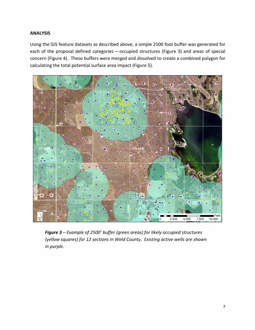
ANALYSIS
Using the GIS feature datasets as described above, a simple 2500 foot buffer was generated for each of the proposal defined categories – occupied structures (Figure 3) and areas of special concern (Figure 4). These buffers were merged and dissolved to create a combined polygon for calculating the total potential surface area impact (Figure 5).
Figure 3 – Example of 2500’ buffer (green areas) for likely occupied structures (yellow squares) for 12 sections in Weld County. Existing active wells are shown in purple.

8
Figure 4 – Example of 2500’ buffer (orange areas) for areas of special concern (i.e. hydrographic features) (blue) for 12 sections in Weld County. Existing active wells are shown in purple.

9
Figure 5 – Example of 2500’ buffer (red areas) for both occupied structure AND area of special concern setback for 12 sections in Weld County. Existing active wells are shown in purple.

10
RESULTS
The 2500’ setback for oil and gas facilities proposed in ballot initiative #78 would result in an estimated 90% of the state’s surface area being unavailable for new oil and gas facility development or hydraulic fracturing operations (Table 1). In the top 5 producing counties 95% of the surface area would be within mandatory setback zones and unavailable for new oil and gas development or hydraulic fracturing operations. The ballot initiative language does not provide any exceptions to or possibility of variance from the mandatory 2,500’ setback distance.
Of the two defined feature categories in the proposed initiative, the setback from an “Area of Special Concern” (which includes lakes, rivers, perennial or intermittent streams, creeks, irrigation canals, and riparian areas) would have a larger impact on surface acreage available for oil and gas facility development statewide. A 2500’ setback from “Area(s) of Special Concern” will result in 89% of the surface land being unavailable for new oil and gas facilities; whereas for “Occupied Structure(s)” the calculated estimate is 22% of the state surface acreage being unavailable. In Weld County, the proposed setback requirement from an “Occupied Structure” will potentially make more than 40% of the land unavailable.
Total area in acres
2500' setback from “Occupied
Structure” in acres (% of total area)
2500' setback from “Area of Special
Concern” in acres (% of total area)
2500' setback from “Occupied Structure” AND “Area of Special
Concern” in acres (% of total area)
Statewide 66,616,355 14,461,299 (21.7%) 59,327,172 (89.1%) 60,109,708 (90.2%)
Weld 2,568,943 1,055,234 (41.1%) 2,043,322 (79.5%) 2,184,240 (85.0%) Garfield 1,893,530 286,835 (15.1%) 1,871,802 (98.9%) 1,873,206 (98.9%) La Plata 1,087,758 442,412 (40.7%) 1,081,498 (99.4%) 1,083,115 (99.6%)
Rio Blanco 2,064,869 224,465 (10.9%) 2,046,974 (99.1%) 2,047,405 (99.2%) Las Animas 3,051,409 530,251 (17.4%) 2,927,861 (96.0%) 2,939,904 (96.3%)
Top 5 Producing Counties 10,666,509 2,539,197 (23.8%) 9,971,456 (93.5%) 10,127,870 (95.0%)
Table 1 – Surface area impacted by proposed 2500’ mandatory setbacks.

11
Maps showing the potential impact of a 2500’ mandatory setback have been generated for the entire state (Figures 5-7) and specifically for the top 5 oil and producing counties (Figures 8-12). Note in many cases the “Area of Special Concern” setback will overlap with the “Occupied Structure” setback; the combined surface impact is only slightly greater, however, than the impact of a area-of-special-concern buffer on its own.
Statewide – 2500’ Setbacks
Figure 5 – 2500’ buffer for occupied structures. Nearly 14.5 million acres of surface area could be affected statewide. No address location data was available for counties outlined in orange; blue-outlined counties are Colorado’s top oil and gas producers.
12
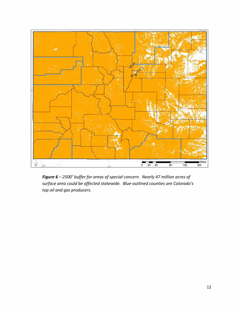
Figure 6 – 2500’ buffer for areas of special concern. Nearly 47 million acres of surface area could be affected statewide. Blue-outlined counties are Colorado’s top oil and gas producers.
13
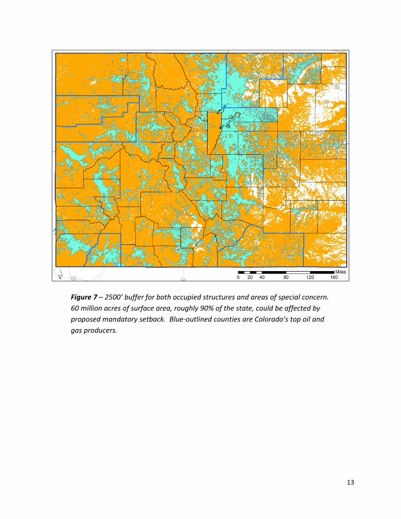
Figure 7 – 2500’ buffer for both occupied structures and areas of special concern. 60 million acres of surface area, roughly 90% of the state, could be affected by proposed mandatory setback. Blue-outlined counties are Colorado’s top oil and gas producers.

14
Colorado’s Top Producing Counties – 2500’ Setbacks 1) Weld County (2,568,943 acres – 22,723 active wells as of 3/31/2016)
Occupied Structures 1,055,234 acres (41.1% of total area)
Areas of Special Concern 2,043,322 acres (79.5% of total area)
Combined impact 2,184,240 acres (85.0% of total area)
Figure 8 – Potential surface impact of 2500’ setbacks for Weld County
15
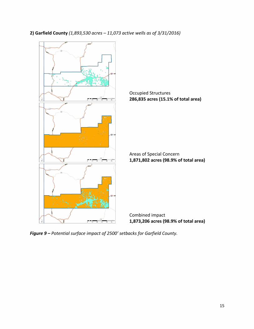
2) Garfield County (1,893,530 acres – 11,073 active wells as of 3/31/2016)
Occupied Structures 286,835 acres (15.1% of total area)
Areas of Special Concern 1,871,802 acres (98.9% of total area)
Combined impact 1,873,206 acres (98.9% of total area)
Figure 9 – Potential surface impact of 2500’ setbacks for Garfield County.

16
3) La Plata County (1,087,758 acres – 3,323 active wells as of 3/31/2016)
Occupied Structures 442,412 acres (40.7% of total area)
Areas of Special Concern 1,081,498 acres (99.4% of total area)
Combined impact 1,083,115 acres (99.6% of total area)
Figure 10 – Potential surface impact of 2500’ setbacks for La Plata County.

17
4) Rio Blanco County (2,064,869 – 2,900 active wells as of 3/31/2016)
Occupied Structures 224,465 acres (10.9% of total area)
Areas of Special Concern 2,046,974 acres (99.1% of total area)
Combined impact 2,047,405 acres (99.2% of total area)
Figure 11 – Potential surface impact of 2500’ setbacks for Rio Blanco County.

18
5) Las Animas County (3,051,409 – 2,946 active wells as of 3/31/2016)
Occupied Structures 530,251 acres (17.4% of total area)
Areas of Special Concern 2,927,861 acres (96.0% of total area)
Combined impact 2,939,904 acres (96.3% of total area)
Figure 12 – Potential surface impact of 2500’ setbacks for Las Animas County.