
20/20 Inner City Development Subcommittee 1 August 2012€¦ · 20/20 Inner City Development (City...
29
20/20 Inner City Development (City Centre/Urban Design) Subcommittee Notice of Meeting A meeting of the 20/20 Inner City Development (City Centre/Urban Design) Subcommittee will be held in the Council Chamber, Forum North, Whangarei on: Wednesday 1 August 2012 1.00 pm Subcommittee of: Council Committee Cr P R Halse (Chairperson) His Worship the Mayor Cr S J Deeming Cr A J Edwards Cr G M Martin Cr K J Sutherland Cr M R Williams
-
Upload
nguyenxuyen -
Category
Documents
-
view
216 -
download
1
Transcript of 20/20 Inner City Development Subcommittee 1 August 2012€¦ · 20/20 Inner City Development (City...

20/20 Inner City Development (City Centre/Urban Design) Subcommittee
Notice of Meeting A meeting of the 20/20 Inner City Development (City Centre/Urban Design) Subcommittee will be held in the Council Chamber, Forum North, Whangarei on:
Wednesday
1 August 2012 1.00 pm
Subcommittee of: Council
Committee Cr P R Halse (Chairperson)
His Worship the Mayor Cr S J Deeming Cr A J Edwards
Cr G M Martin Cr K J Sutherland
Cr M R Williams

20/20 Inner City Development (City Centre/Urban Design) Subcommittee CONFIDENTIAL – not for publication
Notice of Meeting A meeting of the 20/20 Inner City Development (City Centre/Urban Design) Subcommittee will be held in the Council Chamber, Forum North, Whangarei on:
Wednesday
1 August 2012 1.00 pm
Subcommittee of: Council
Committee Cr P R Halse (Chairperson)
His Worship the Mayor Cr S J Deeming Cr A J Edwards
Cr G M Martin Cr K J Sutherland
Cr M R Williams
INDEX Item No Page No 1. Walkway Stage 2 – Loop Walkway ........................................................................................... 1
CONFIDENTIAL INDEX Item No Page No C.1 Carpark ..................................................................................................................................... 1

20/20 Inner City Development (City Centre / Urban Desgin) Subcommittee 1 August 2012
1. Walkway Stage 2 - Loop Walkway
Reporting officer Bruno Gilmour (Senior Landscape Architect)
Date July 2012
Vision, Mission and Values
This project will contribute to the vision of creating a vibrant, attractive and thriving District by finalising a walking and cycle way loop 4 kilometres long around the inner harbour and through the Town Basin. This will enhance Sense of Place objectives through providing a remarkable open space experience particular to Whangarei, showcasing existing facilities, while providing a framework for future activities. The walkway will be an attraction for current Whangarei residents, as well as contributing significantly to the larger Sense of Place mission to attract potential residents to the city.
Local Government Act 2002 – The four well-beings
Cultural This project will provide connections between a range of existing cultural elements such as the heritage walk and art park, Reyburn House, Okara, and Pohe Island. Opening up the Okara section of the walkway, currently cut off and neglected, will be a significant step toward incorporating that landscape back into cultural and community stewardship.
Economic The project aims to be a draw card, attracting potential residents to Whangarei, thereby contributing to the local economy. On a smaller scale, the framework of the walkway loop will provide opportunity for small businesses to take advantage of the increased use of currently outlying areas around the inner harbour.
Environmental The environment of the Hatea Riverbank on the true right (Okara), will be considerably enhanced through the development of the walkway. Increased patronage of the Pohe Island section will bring with it improved environment as node of increased activity are developed, along with improved access. Hihiaua’s environment will be improved through improved drainage among other measures.
Social The project creates a framework for raising the social profile of areas through which it passes, while enhancing opportunities for social engagement, whether they be regular events along its route, the social acts of walking and cycling with others, or events that will be based around the use of the walkway itself.
Background
Council at it’s meeting of the 28th March 2012 approved construction of further stages of the looped walkway
within existing budget.
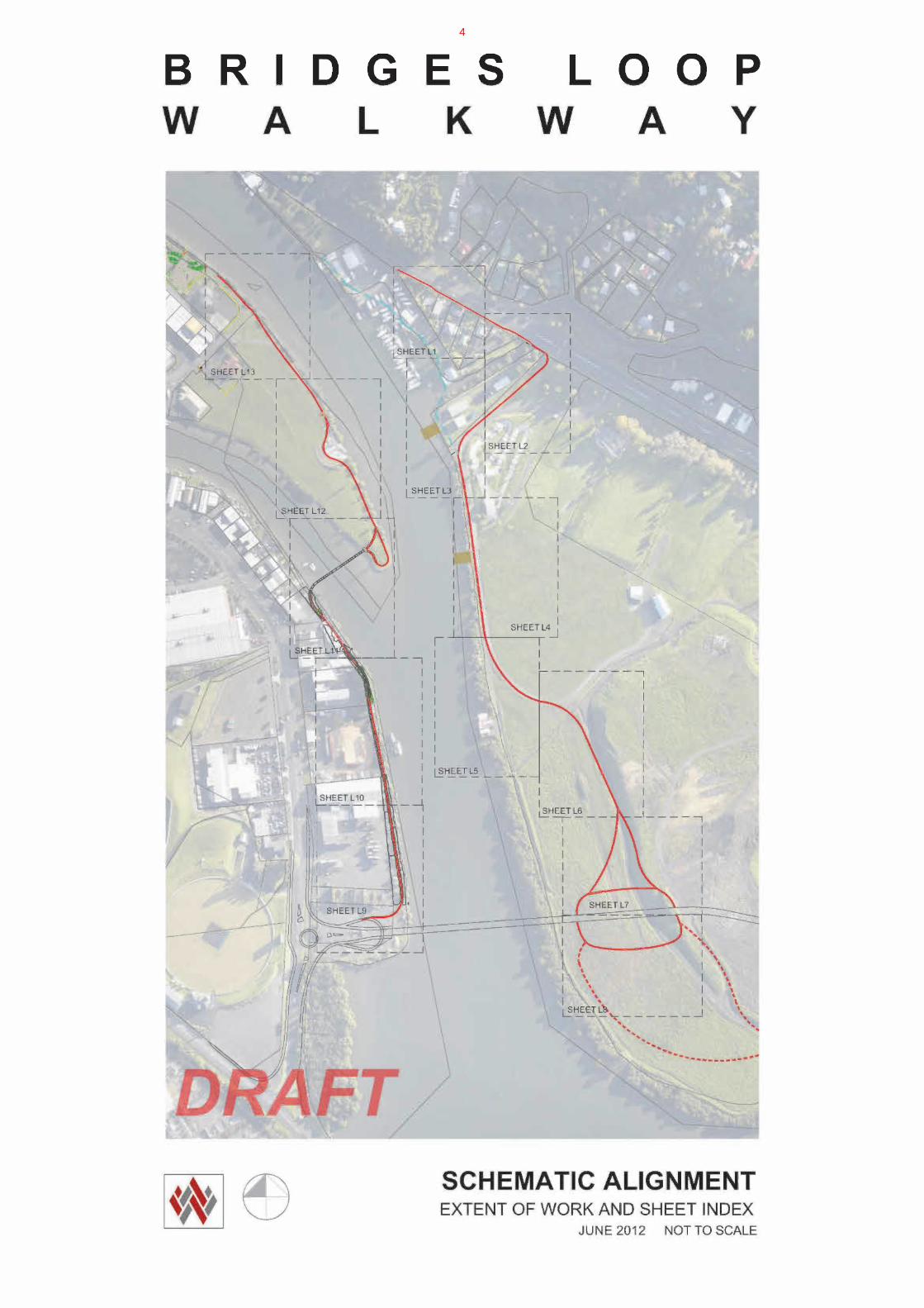
This project builds on work completed in 2011 including the Art Park, Heritage Walk and Hihiaua walkway, as well as along Riverside Drive, to create a 4 kilometer cycle and pedestrian loop around the inner harbor and Town Basin. This document provides an overview of Stage 2 of the Ring of Walkways, currently referred to as The Loop Walkway. A separate visioning document was developed for the Loop Walkway between January and March 2012. (Attached). The walkway sits within the allocation from the current Long Term Plan (LTP) (including carry forward), with a budget of approximately $1.1 million dollars.
The Loop Walkway route
In its simplest sense, this is a 2.5 meter wide high quality concrete trail, functioning as a framework which will support diverse public activities at various points along its route. Some of these already exist, while others are planned for the future. The walkway will be accessible by vehicle at numerous points along its route, with car park facilities already in existence, and more planned.
The walkway contains two significant sections of new 2.5m wide concrete path. From the path completed to the end of the Hihiaua peninsula in 2011, the walkway will cross a proposed cycle and pedestrian cycle opening bridge over the Waiarohia River, (separate project), to arrive on the Okara side. This is the start of one of the two main new sections of walkway.
1

From this landing point, the walkway follows the river’s edge between the CMA and property boundaries south for approximately 500 meters, to the Lower Hatea bascule traffic bridge.
Having crossed the bridge, the route lands on Pohe Island, the second major section of new walkway. It then heads north west to the water’s edge, before connecting back to Riverside Drive at the north east corner of William Frazer Park.
Below are more detailed descriptions of all component sections of the Loop Walkway.
Hihiaua Section
Drainage will be installed throughout the section of Hihiaua from south of Riverside Theater car park, to the general location of the Wave Waka sculpture. This will be similar to that installed as a first step in the recent development of the Art Park, and seen contributing to that projects year round appeal and usability.
To better integrate the Wave and Waka sculpture into the experience of Hihiaua and the Loop Walkway, a curved section of path is being added, to allow pedestrians and cyclists to flow around the outside of the sculpture, rather than ‘dead end’ at it. In addition, seating is being added, to match the swing back benches in the Art Park and Town Basin, along with a heritage plinth, detailing the story behind the sculpture. As lighting is provided for the walkway route along the water’s edge of Hihiaua, it will be upgraded at the sculpture, to improve security and consistency with other lighting in the area.
Also work is being undertaken to improve existing features in the area of Reyburn House. This includes: Improved drainage and ground levels at the boardwalk, a concrete path connection between the promenade boardwalk and the path between Reyburn house and the art studio, removal of palms to facilitate the planting of heritage roses, and the addition of a heritage plinth.
Much of the actual walkway on Hihiaua is established. Lighting will be provided from the Art Park, (to match lighting in that location), along the walkway, to the end of the peninsula where the walkway will be connected to the proposed Waiarohia pedestrian and cycle opening bridge.
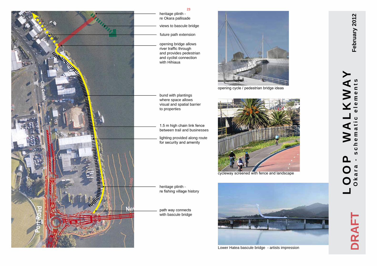
Wairohia Pedestrian and Cycle Opening Bridge
While a separate project with its own budget, this bridge will be designed specifically to accommodate the Loop Walkway. As such, the western end will be oriented to allow the best flow of pedestrians and cyclists to and from the narrow strip between the top of river bank, and the property boundaries.
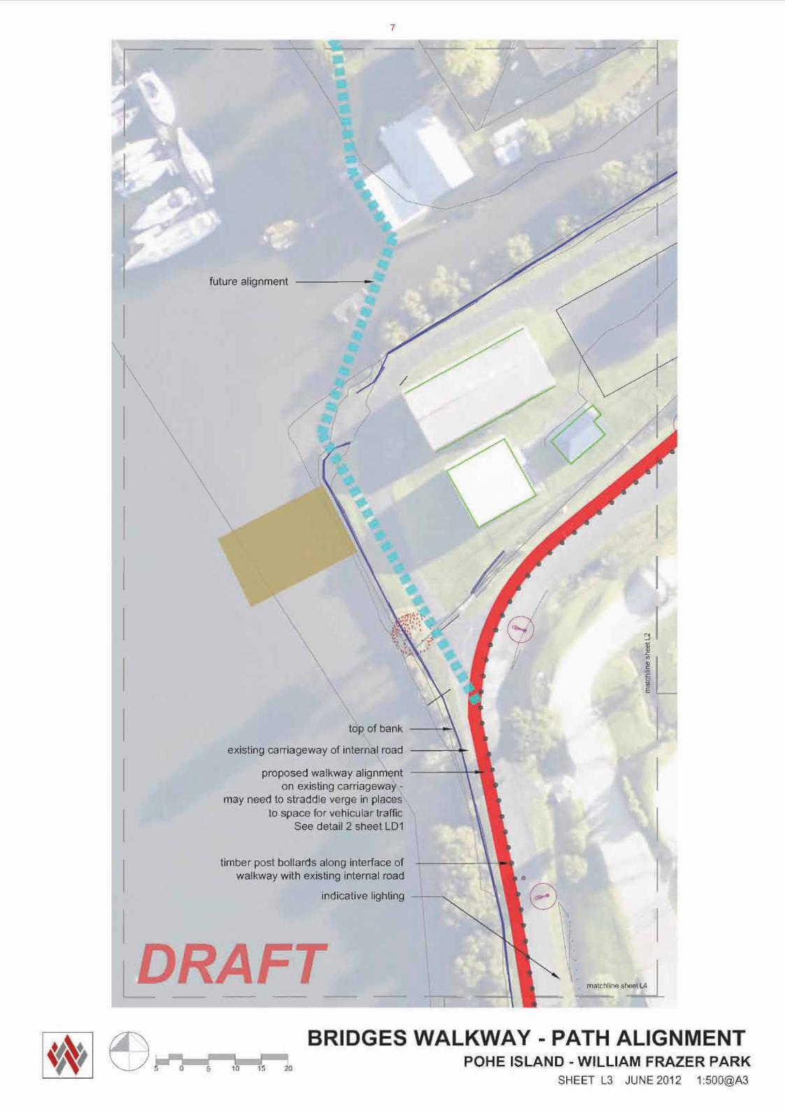
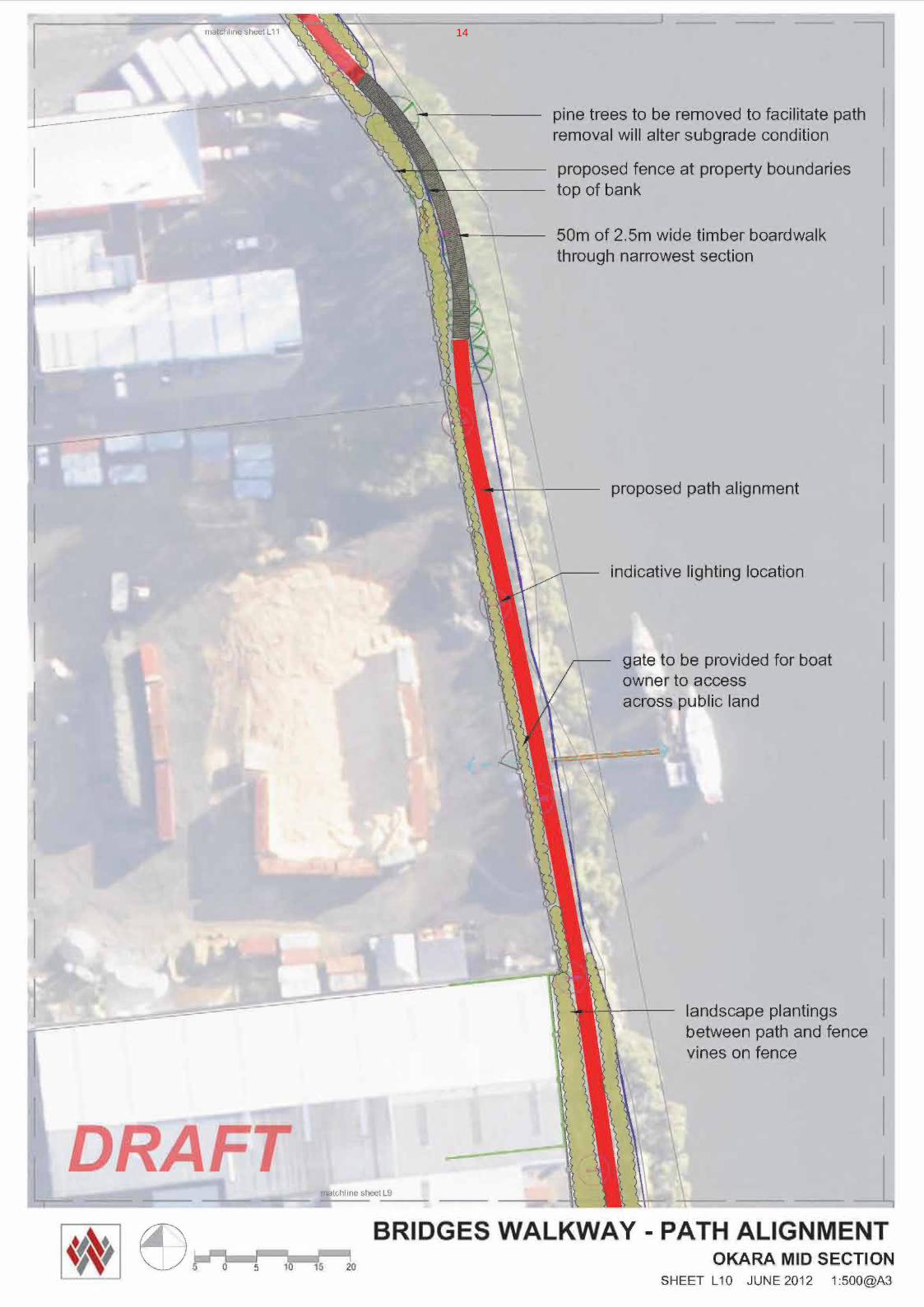
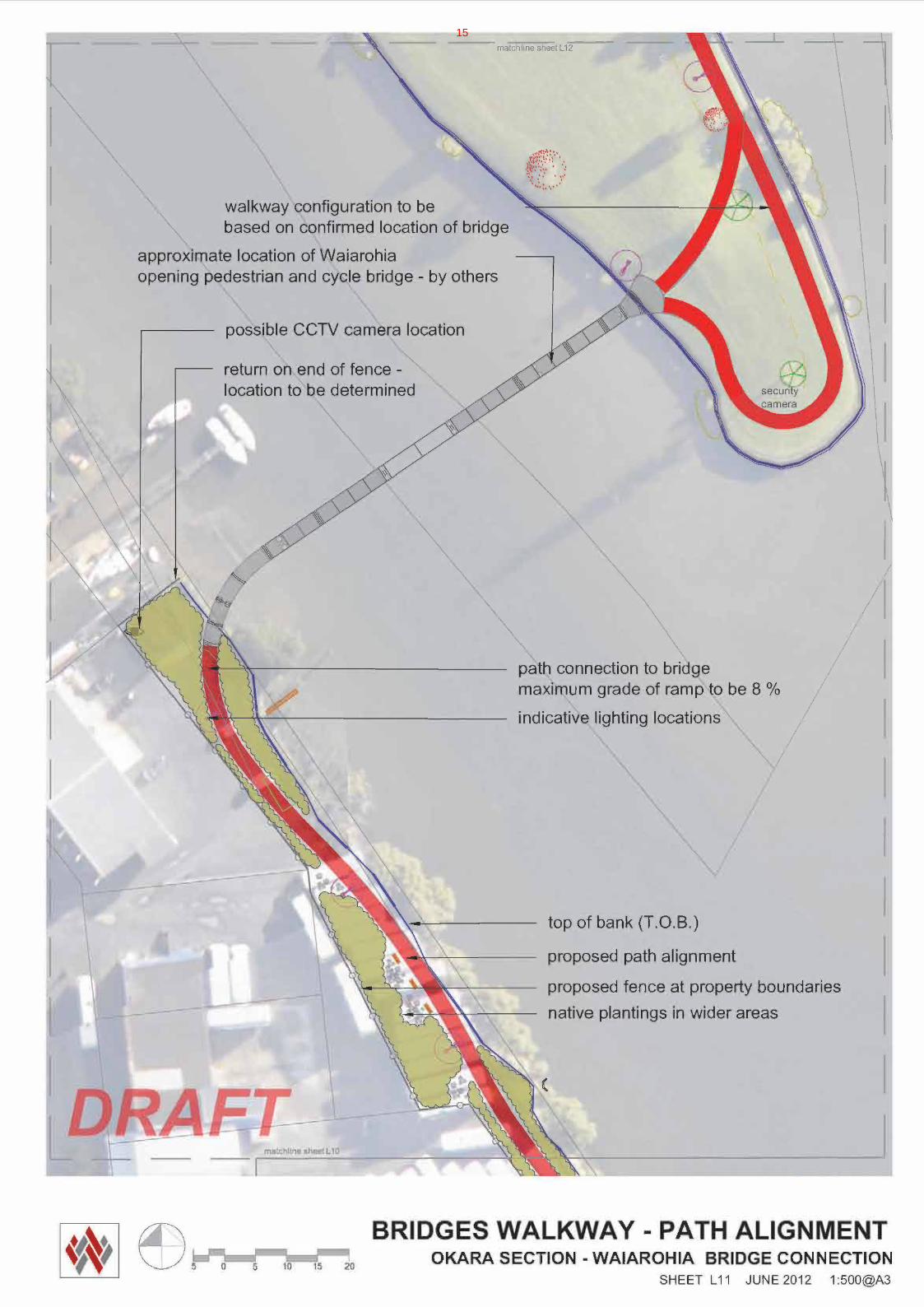
Okara section
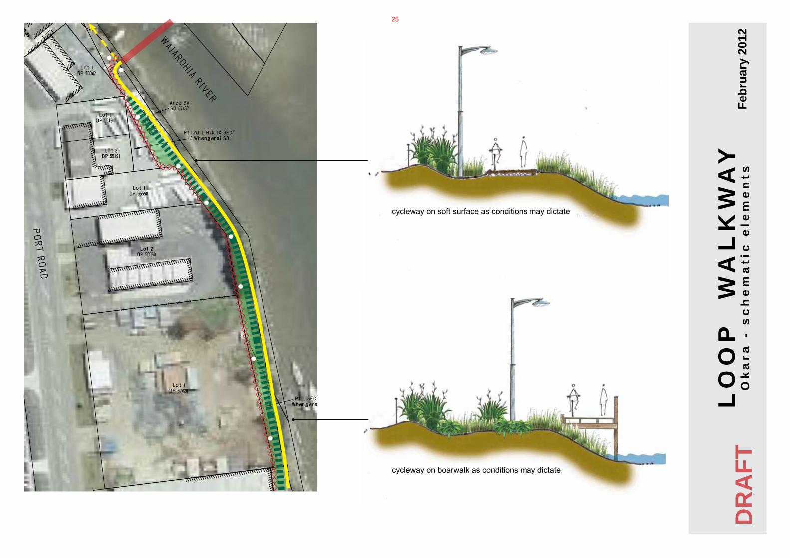
Leaving the bridge, the walkway heads south along the edge of the Hatea River. The ground conditions in this area are varied, with some areas fairly solid, with others that are loose and unconsolidated. The path structure in this section will be 100mm thick concrete with steel mesh throughout. In areas considered more susceptible to subsidence, steel reinforcing rods may be required through the length of the path.
A crux along the section of the route exists where property boundaries run close to the top of the river bank, separated only by a rough row of mature pine trees. These trees will shortly be felled, as they are weed species. At this stage a clearer understanding of the ground condition will be apparent. A section of boardwalk may be needed for this approximately 50m section.
A chain link fence will be provided along the property boundaries that define the western edge of the space, with landscape plantings mediating between this and the walkway. Lighting will be provided in the same manner as at Hihiaua. At the southern end of the Okara section, the walkway connects with the Lower Hatea bascule traffic bridge, to cross the river to Pohe Island.
Staff from the Property Department have been liaising with landowners over the timing of the project and when certain activities are programmed to commence.
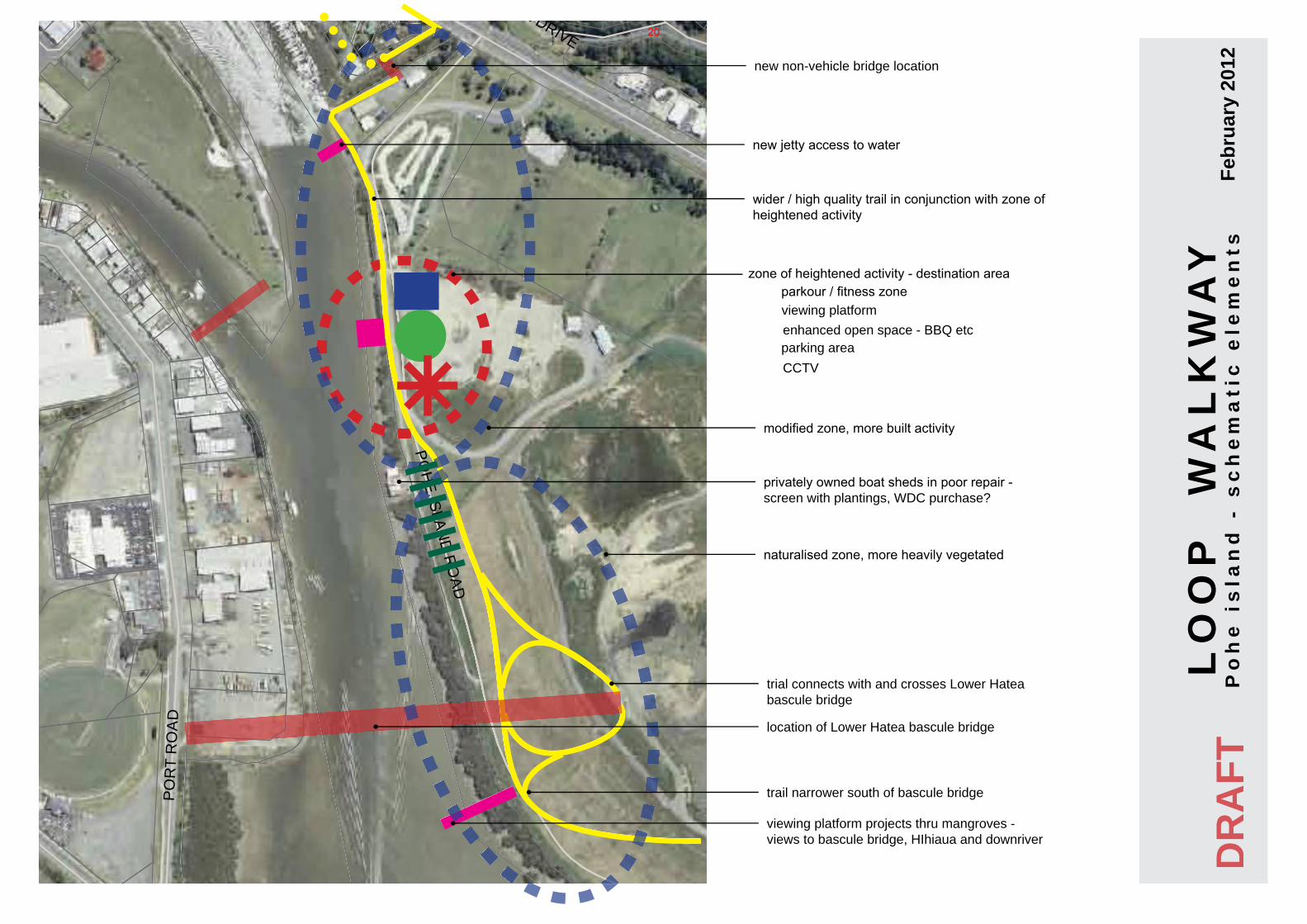
Pohe Island section of Loop Walkway
From the bascule bridge, the Loop Walkway will connect with another section of pathway that will swings south and east to connect with Riverside Drive on the Onerahi side of Pohe Island.
From the bascule traffic bridge the walkway heads north traversing a relatively steep slope, at grades no greater that 1:12, to reach lower ground. Being on a landfill, there is no opportunity to cut into the clay cap to form the bench for the walkway, so this section will be built on imported structural fill.
2

At the bottom of the slope, the walkway joins the existing internal road, which in the past has been used for rally sprint events. With the construction of the new bridge, this section of gravel road will be truncated.
Crossing an existing drain by means of a culvert, the walkway joins another internal road, sharing the carriageway, to reach the water’s edge to the North West.
The carriageway is between six and eight meters wide and as such is considered to be suitable for supporting the walkway as well as the limited vehicular traffic that still use it. Timber bollards will provide a safe buffer between vehicles and walkway users. As access into William Frazer Park at Pohe Island is refined in the short to medium future, it is expected that vehicle traffic on this particular stretch will be further reduced. This alignment, sharing existing carriageways, allows savings in construction, since existing structures will be more stable and require less structural work than crossing open ground on the capped landfill. The same reasoning suggests that the walkway be last longer on the existing carriageway than it would otherwise. Also, this route achieves the best balance of visual experience with manageable grades for young cyclists, wheel chairs, prams etc.
The walkway travels north along the edge of the carriage way on the true left of the river’s edge, until it reaches the buildings of the rowing club. Here it turns away from the water to the east, to reach Riverside Drive. In the longer term, the preferred route stays close to the water, past the marina, to connect with the park approximately 200m to the north. In the shorter term, alignment, CPTED and cost issues have precluded this option.
In response to the challenges of building a high quality 2.5m wide concrete trail on a capped landfill, the walkway on the Pohe island will have steel mesh along with steel reinforcing bars running along its length. The alignment on Pohe Island has been reviewed by a civil engineer, and the route and structural details will be further reviewed for rigor as construction drawings are developed.
The walkway on Pohe Island will be lighted in a manner similar to the river edge walkway on Hihiaua, which will be clearly visible across the water, reinforcing the connectivity that the walkway establishes.
Work programme
Currently completed, the schematic alignment master plan. Next step will be detailed design, with a view to developing biddable construction documentation. Construction, due to the various components, contingent projects (bridges), and site locations, will be phased, with a possible start date of September 2012. The bulk of work will take place in the first half of 2013, with construction is to be completed in time for the opening of the Lower Hatea Bascule traffic bridge, on 1 July 2013.
Recommendation
1 That the report be received.
2 That the project proceeds for detailed design, construction documentation and construction with a view to having the works completed by June 2013.
Attachments:
1 Schematic alignment master plan
2 ROW Vision
3
4

5

6
7

8

9

10

11

12

13
14
15

16

17

18

RIVERSIDE DRIVE
DENT STREET
PO
RT
RO
AD
OK
ARA
DR
IVE
NORTH AUCKLANDLINE
MEMORIAL DRIVE
POH
EISLAN
DR
OA
D
POROWINI AVENUE
MORNINGSIDE ROAD
ROBERT STREET
WALTON
STREET
RAILWAY ROAD (CITY)
BAN
KST
REE
T
JOHN
STREET
KA
KA
STR
EE
T
COMMERCE STREET
HANNAHSTREET
HEREKINO STREET
JAMES
STREET
REYBURN HOUSE LANE
DUNDAS ROAD
QUAYSIDE
CAMERONSTREET
ALBERT STREET
TANEKAHA DRIVE
EUREKA PLACE
RATHBONE
STREET
CARRUTHSTREET
CLYDESTREET
KOHE STREET
VALE ROAD
VINE STREET
THE BLUFF
RE
YB
UR
NS
TRE
ET
PANORAMA DRIVE
FINL
AYSO
NST
REET
WO
OD
SR
OAD
JELLICOE STREET
THE
GR
OV
E
LIMEBURNERS STREET
EWIN
GROAD
KAURI PLACE
ALBERT STREET SERVICE LANE
CAMERONSTREET MALL
REYBURNSTREET
LO
OP
W
AL
KW
AY
cu
rre
nt
ph
as
es
of
de
ve
lop
me
nt
Feb
ruar
y 20
12
Riverside Drive (stage 4 Ring of Walkways)
Hihiaua peninsula(stage 2 Ring of Walkways)
Pohe Island section (stage 6 Ring of Walkways)
Okara Industrial trail (stage 7 Ring of Walkways)
DR
AFT
Waiarohia opening bridge - cycle and pedestrian link(stage 7 Ring of Walkways)
POH
EISLAN
DR
OA
D
POH
EISLAN
DR
OA
D
POH
EISLAN
DR
OA
D
POH
EISLAN
DR
OA
D
POH
EISLAN
DR
OA
D
POH
EISLAN
DR
OA
D
MEMORIAL DRIVE
MEMORIAL DRIVE
MEMORIAL DRIVE
MEMORIAL DRIVE
MEMORIAL DRIVE
19
RIVERSIDE DRIVE
DENT STREET
PO
RT
RO
AD
OK
ARA
DR
IVE
NORTH AUCKLANDLINE
MEMORIAL DRIVE
POH
EISLAN
DR
OA
D
POROWINI AVENUE
MORNINGSIDE ROAD
ROBERT STREET
WALTON
STREET
RAILWAY ROAD (CITY)
BAN
KST
REE
T
JOHN
STREET
KA
KA
STR
EE
T
COMMERCE STREET
HANNAHSTREET
HEREKINO STREET
JAMES
STREET
REYBURN HOUSE LANE
DUNDAS ROAD
QUAYSIDE
CAMERONSTREET
ALBERT STREET
TANEKAHA DRIVE
EUREKA PLACE
RATHBONE
STREET
CARRUTHSTREET
CLYDESTREET
KOHE STREET
VALE ROAD
VINE STREET
THE BLUFF
RE
YB
UR
NS
TRE
ET
PANORAMA DRIVE
FINL
AYSO
NST
REET
WO
OD
SR
OAD
JELLICOE STREET
THE
GR
OV
E
LIMEBURNERS STREET
EWIN
GROAD
KAURI PLACE
ALBERT STREET SERVICE LANE
CAMERONSTREET MALL
REYBURNSTREET
location of Lower Hatea bascule bridge
parking area
viewing platform projects thru mangroves -views to bascule bridge, HIhiaua and downriver
LO
OP
W
AL
KW
AY
Po
he
is
lan
d -
sc
he
ma
tic
ele
me
nts
Feb
ruar
y 20
12
viewing platform parkour / fitness zone
zone of heightened activity - destination area
wider / high quality trail in conjunction with zone of heightened activity
trail narrower south of bascule bridge
trial connects with and crosses Lower Hatea bascule bridge
new non-vehicle bridge location
enhanced open space - BBQ etc
CCTV
privately owned boat sheds in poor repair - screen with plantings, WDC purchase?
modified zone, more built activity
naturalised zone, more heavily vegetated
DR
AFT
new jetty access to water
POH
EISLAN
DR
OA
D
POH
EISLAN
DR
OA
D
POH
EISLAN
DR
OA
D
POH
EISLAN
DR
OA
D
POH
EISLAN
DR
OA
D
20

RIVERSIDE DRIVE
DENT STREET
PO
RT
RO
AD
OK
ARA
DR
IVE
NORTH AUCKLANDLINE
MEMORIAL DRIVE
POH
EISLAN
DR
OA
D
POROWINI AVENUE
MORNINGSIDE ROAD
ROBERT STREET
WALTON
STREET
RAILWAY ROAD (CITY)
BAN
KST
REE
T
JOHN
STREET
KA
KA
STR
EE
T
COMMERCE STREET
HANNAHSTREET
HEREKINO STREET
JAMES
STREET
REYBURN HOUSE LANE
DUNDAS ROAD
QUAYSIDE
CAMERONSTREET
ALBERT STREET
TANEKAHA DRIVE
EUREKA PLACE
RATHBONE
STREET
CARRUTHSTREET
CLYDESTREET
KOHE STREET
VALE ROAD
VINE STREET
THE BLUFF
RE
YB
UR
NS
TRE
ET
PANORAMA DRIVE
FINL
AYSO
NST
REET
WO
OD
SR
OAD
JELLICOE STREET
THE
GR
OV
E
LIMEBURNERS STREET
EWIN
GROAD
KAURI PLACE
ALBERT STREET SERVICE LANE
CAMERONSTREET MALL
REYBURNSTREET
LO
OP
W
AL
KW
AY
Po
he
is
lan
d -
sc
he
ma
tic
ele
me
nts
Feb
ruar
y 20
12
parking area
open gathering spaceviewing deck over river
parkour / adult play areas
DR
AFT
parkour - illustration only
parkour - illustration only
viewing deck - illustration only
POH
EISLAN
DR
OA
D
POH
EISLAN
DR
OA
D
21

cycleway on boardwalk - timber surface
LO
OP
W
AL
KW
AY
Po
he
is
lan
d -
sc
he
ma
tic
ele
me
nts
Feb
ruar
y 20
12
cycleway just above bund - concrete surface
DR
AFT
cycleway traversing slope - fill / retaining required.
RIVERSIDE DRIVE
DENT STREET
PO
RT
RO
AD
OK
ARA
DR
IVE
NORTH AUCKLANDLINE
MEMORIAL DRIVE
POH
EISLAN
DR
OA
D
POROWINI AVENUE
MORNINGSIDE ROAD
ROBERT STREET
WALTON
STREET
RAILWAY ROAD (CITY)
BAN
KST
REE
T
JOHN
STREET
KA
KA
STR
EE
T
COMMERCE STREET
HANNAHSTREET
HEREKINO STREET
JAMES
STREET
REYBURN HOUSE LANE
DUNDAS ROAD
QUAYSIDE
CAMERONSTREET
ALBERT STREET
TANEKAHA DRIVE
EUREKA PLACE
RATHBONE
STREET
CARRUTHSTREET
CLYDESTREET
KOHE STREET
VALE ROAD
VINE STREET
THE BLUFF
RE
YB
UR
NS
TRE
ET
PANORAMA DRIVE
FINL
AYSO
NST
REET
WO
OD
SR
OAD
JELLICOE STREET
THE
GR
OV
E
LIMEBURNERS STREET
EWIN
GROAD
KAURI PLACE
ALBERT STREET SERVICE LANE
CAMERONSTREET MALL
REYBURNSTREET
POH
EISLAN
DR
OA
D
POH
EISLAN
DR
OA
D
22
1.5 m high chain link fence between trail and businesses
LO
OP
W
AL
KW
AY
Ok
ara
- s
ch
em
ati
c e
lem
en
ts F
ebru
ary
2012
DR
AFT
lighting provided along routefor security and amenity
bund with plantingswhere space allows visual and spatial barrier to properties
opening bridge allows river traffic through and provides pedestrian and cyclist connection with Hihiaua
views to bascule bridge
path way connects with bascule bridge
heritage plinth -re Okara pallisade
heritage plinth -re fishing village history
future path extension
opening cycle / pedestrian bridge ideas
cycleway screened with fence and landscape
Lower Hatea bascule bridge - artists impression
23

REYBURNBRYANT
SURVEYORS, PLANNERS &
PROJECT MANAGERS
7 Selwyn Ave - Whangarei Ph (09) 438 3563 - Fax (09) 438 0251
Email: [email protected]
Reyburn & Bryant 1999 LtdPO Box 191
Web: http://www.reyburnandbryant.co.nz
LO
OP
W
AL
KW
AY
Ok
ara
- s
ch
em
ati
c e
lem
en
ts F
ebru
ary
2012
heritage plinth as exists in Art Park
cycleway screened with fence and landscape
DR
AFT
24
REYBURNBRYANT
SURVEYORS, PLANNERS &
PROJECT MANAGERS
7 Selwyn Ave - Whangarei Ph (09) 438 3563 - Fax (09) 438 0251
Email: [email protected]
Reyburn & Bryant 1999 LtdPO Box 191
Web: http://www.reyburnandbryant.co.nz
LO
OP
W
AL
KW
AY
Ok
ara
- s
ch
em
ati
c e
lem
en
ts F
ebru
ary
2012
cycleway on soft surface as conditions may dictate
cycleway on boarwalk as conditions may dictate
DR
AFT
25
RIVERSIDE DRIVE
DENT STREET
PO
RT
RO
AD
OK
ARA
DR
IVE
NORTH AUCKLANDLINE
MEMORIAL DRIVE
POH
EISLAN
DR
OA
D
POROWINI AVENUE
MORNINGSIDE ROAD
ROBERT STREET
WALTON
STREET
RAILWAY ROAD (CITY)
BAN
KST
REE
T
JOHN
STREET
KA
KA
STR
EE
T
COMMERCE STREET
HANNAHSTREET
HEREKINO STREET
JAMES
STREET
REYBURN HOUSE LANE
DUNDAS ROAD
QUAYSIDE
CAMERONSTREET
ALBERT STREET
TANEKAHA DRIVE
EUREKA PLACE
RATHBONE
STREET
CARRUTHSTREET
CLYDESTREET
KOHE STREET
VALE ROAD
VINE STREET
THE BLUFF
RE
YB
UR
NS
TRE
ET
PANORAMA DRIVE
FINL
AYSO
NST
REET
WO
OD
SR
OAD
JELLICOE STREET
THE
GR
OV
E
LIMEBURNERS STREET
EWIN
GROAD
KAURI PLACE
ALBERT STREET SERVICE LANE
CAMERONSTREET MALL
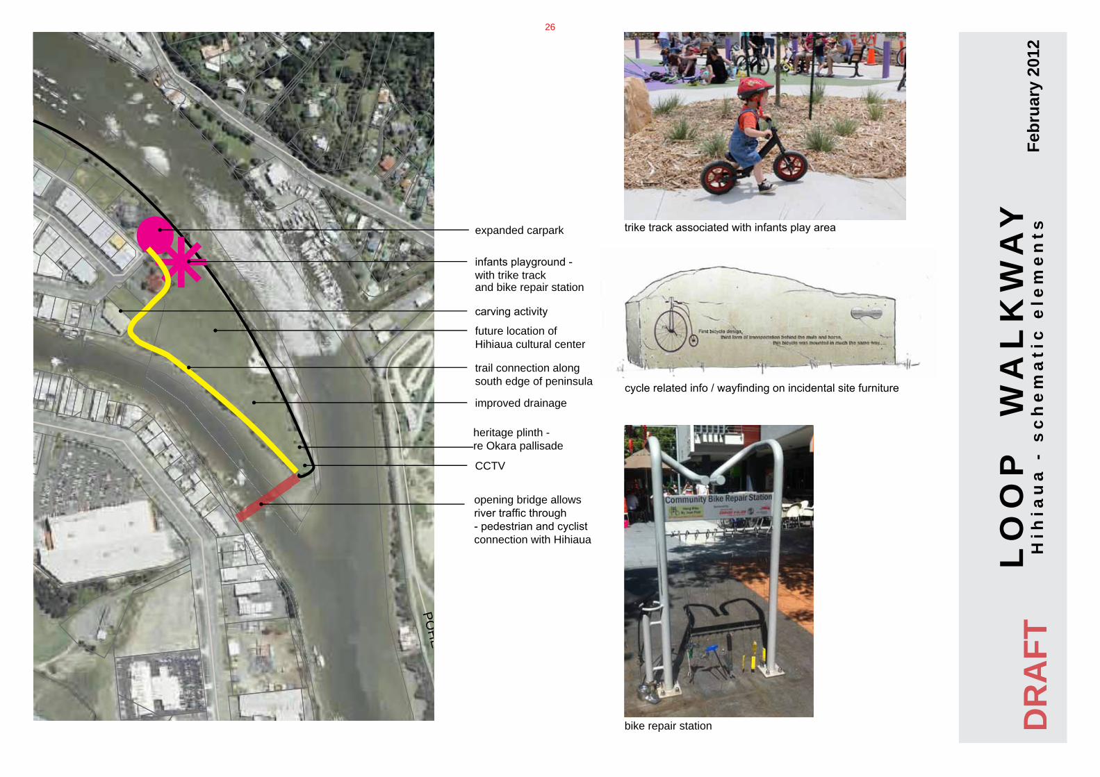
REYBURNSTREET expanded carpark
LO
OP
W
AL
KW
AY
Hih
iau
a -
sc
he
ma
tic
ele
me
nts
Feb
ruar
y 20
12
infants playground - with trike track
future location of Hihiaua cultural center
trike track associated with infants play area
cycle related info / wayfinding on incidental site furniture
bike repair station
trail connection along south edge of peninsula
CCTV
and bike repair station
improved drainage
carving activity
DR
AFT
opening bridge allows river traffic through - pedestrian and cyclist connection with Hihiaua
heritage plinth -re Okara pallisade
26