2011 MORGANZA CONTROL STRUCTURE TAILBAY …€¦ · · 2015-05-19are that tailwater conditions...
12
1 2011 MORGANZA CONTROL STRUCTURE TAILBAY SCOUR DEVELOPMENT & SEDIMENT DISTRIBUTION T. (Jerry) Shih, Ph.D., P.E., U.S. Army Corps of Engineers, New Orleans, Louisiana, [email protected] Suchen Chien, U.S. Army Corps of Engineers, New Orleans, Louisiana, [email protected] Abstract Completed in February 1954, the Morganza Control Structure (MCS) is a very unique Mississippi River flow diversion structure. When the forebay stage reaches 56.0 feet design height, the MCS is capable of diverting 600,000 cubic feet per section (cfs) water. Since completion, the MCS has been used to divert the flood water twice. The first operation was started on April 17, 1973. The 1973 diversion caused significant scour at the MCS tailbay. As a remedy to protect the MCS tailbay from future scour, a reinforced concrete plunge pool was built in 1977. The second operation was started on May 15, 2011, but significant scour occurred again and promulgated even further downstream. Six multi-beam surveys were performed between May 17 and June 6, 2011 to monitor the scour development. Each survey showed new scour holes and the development of original findings. The most severe scour holes were approximately 30 feet lower than their original elevations. Scour holes were un-watered in April 2012 and a Terrestrial LiDAR survey was performed on June 23, 2012. According to the survey results scour holes continued to develop after June 6, 2011, but they were not as severe as those in the early operation. In May 2011, USGS performed a preliminary sediment deposition survey. Daniel Kroes et al. found that an estimated 326,000 cubic yards of dense soil were scoured away immediately downstream of the structure. The scoured soil became approximately 571,000 cubic yards of loose sediment and was deposited at least 30 miles from the MCS. If sediment that was deposited in the forebay and the sediment that came through the structure are included, the deposited sediment could be as high as 2 million cubic yards. USACE’s Engineering & Research Development Center (ERDC) was asked to perform an investigational study using a physical model as it is better than the numerical model for this type of rehabilitation experiment. After 18 months of repair and construction, successfully completed in March 2014, the MCS is now ready and capable of passing the project flood. Based on ERDC’s modeled results, three principle reasons caused the 2011 MCS tailbay scouring: (1) little to no tailwater immediately behind the structure (2) benchmarked headwater stage had been increased since the structure was constructed in 1954 and (3) only some of the 125 gates were used to pass the flood waters. Lessons learned from both 1973 and 2011 operations and ERDC’s physical model experiment are that tailwater conditions are critical for the stilling basin design and energy dissipation calculation, operation needs to be maintained no more than the maximum headwater design stage, and gate operations are extremely important to minimize and prevent tailbay scour.
Transcript of 2011 MORGANZA CONTROL STRUCTURE TAILBAY …€¦ · · 2015-05-19are that tailwater conditions...

1
2011 MORGANZA CONTROL STRUCTURE TAILBAY SCOUR DEVELOPMENT &
SEDIMENT DISTRIBUTION
T. (Jerry) Shih, Ph.D., P.E., U.S. Army Corps of Engineers, New Orleans, Louisiana,
Suchen Chien, U.S. Army Corps of Engineers, New Orleans, Louisiana,
Abstract Completed in February 1954, the Morganza Control Structure (MCS) is a very unique
Mississippi River flow diversion structure. When the forebay stage reaches 56.0 feet design
height, the MCS is capable of diverting 600,000 cubic feet per section (cfs) water. Since
completion, the MCS has been used to divert the flood water twice.
The first operation was started on April 17, 1973. The 1973 diversion caused significant scour at
the MCS tailbay. As a remedy to protect the MCS tailbay from future scour, a reinforced
concrete plunge pool was built in 1977. The second operation was started on May 15, 2011, but
significant scour occurred again and promulgated even further downstream.
Six multi-beam surveys were performed between May 17 and June 6, 2011 to monitor the scour
development. Each survey showed new scour holes and the development of original findings.
The most severe scour holes were approximately 30 feet lower than their original elevations.
Scour holes were un-watered in April 2012 and a Terrestrial LiDAR survey was performed on
June 23, 2012. According to the survey results scour holes continued to develop after June 6,
2011, but they were not as severe as those in the early operation.
In May 2011, USGS performed a preliminary sediment deposition survey. Daniel Kroes et al.
found that an estimated 326,000 cubic yards of dense soil were scoured away immediately
downstream of the structure. The scoured soil became approximately 571,000 cubic yards of
loose sediment and was deposited at least 30 miles from the MCS. If sediment that was
deposited in the forebay and the sediment that came through the structure are included, the
deposited sediment could be as high as 2 million cubic yards.
USACE’s Engineering & Research Development Center (ERDC) was asked to perform an
investigational study using a physical model as it is better than the numerical model for this type
of rehabilitation experiment. After 18 months of repair and construction, successfully completed
in March 2014, the MCS is now ready and capable of passing the project flood.
Based on ERDC’s modeled results, three principle reasons caused the 2011 MCS tailbay
scouring: (1) little to no tailwater immediately behind the structure (2) benchmarked headwater
stage had been increased since the structure was constructed in 1954 and (3) only some of the
125 gates were used to pass the flood waters.
Lessons learned from both 1973 and 2011 operations and ERDC’s physical model experiment
are that tailwater conditions are critical for the stilling basin design and energy dissipation
calculation, operation needs to be maintained no more than the maximum headwater design
stage, and gate operations are extremely important to minimize and prevent tailbay scour.

2
INTRODUCTION
Completed in February 1954, the Morganza Control Structure (MCS) is a very unique
Mississippi River flow diversion structure. The MCS forebay and the Mississippi River are
separated by a three-mile long potato ridge. The waters of the Mississippi River can flood the
MCS forebay when the stage is above elevation 43.0 feet NGVD29. When the forebay stage
reaches 56.0 feet design height, the MCS is capable of diverting 600,000 cfs water.
The structure has 125 gate bays and is 3,906 feet long. Each gate bay has a crest weir with a top
elevation of 37.5 feet NGVD29, and on top of the crest weir is a two-leaf (upper and lower
panel) gate. According to the current MCS water control manual, a gate shall be either fully
opened or closed to divert sufficient floodwater from the Mississippi River to avoid unacceptable
stress along the main stem of the Mississippi River. At the toe of the weir’s downfall, there are
two rows of baffle blocks installed on the stilling basin floor to dissipate the energy of the
floodwaters passing through the structure. The floor and end-sill wall of the 86 feet long stilling
basin is at elevation 29.0 and 32.0 feet NAVD29, respectively. Behind the end-sill wall, there is
an 80 feet long extended derrick stone apron installed parallel to the structure as shown in Figure
1.
Figure 1 The Morganza Control Structure (MCS) in 1954
The operation of the MCS is based on a Mississippi River and Tributaries flood damage risk
reduction feature called “Project Flood” to prevent riverine flood stages from (1) exceeding the
approved flow line, i.e. encroachment on freeboard requirements, (2) limiting flows to design
discharge of 1,500,000 cfs between MCS and Bonnet Carre Spillway, and (3) limiting flow
below the Bonnet Carre Spillway to the design flow of 1,250,000 cfs.

3
1973 OPERATION
Since completion, the MCS has been used to divert the flood water twice. The first operation
was started on April 17, 1973. The operation was not triggered by the Mississippi River flow
rate, but by the vulnerability of the Atchafalaya River primary diversion facility, the Old River
Control Structure. At the peak stage, 46.0 feet, approximately 210,000 cfs were diverted by the
MCS. The 1973 diversion caused significant scour at the MCS tailbay. As a remedy to protect
the MCS tailbay from future scour, a reinforced concrete plunge pool was built in 1977 as shown
in Figure 2.
Figure 2 The MCS with Plunge Pool in 1976
The pool is located downstream of the derrick stone apron, between Gates 42 and 86, which had
a Vertical (V)/Horizontal (H) =1/10 concrete paved front slope and a V/H=1/4 back slope. The
plunge pool bottom was partially lined with concrete and riprap with a bottom elevation of 19.0
feet NGVD29. The horizontal distances of concrete and riprap varied from 90 feet to 110 feet
and 10 feet to 30 feet, respectively. The front and back slopes met with ground elevations at
31.0 feet and 32.0 feet NGVD29, respectively. The repair made in 1977 was believed to be
sufficient in preventing future scour.
2011 SCOUR DAMAGES
The second operation was started on May 15, 2011. While the operation in 2011 was successful,
significant scour occurred which promulgated even further downstream. During the 2011 flood

4
fight, even though the highest forebay stage was 59.6 feet, the maximum diversion flow rate was
only 185,000 cfs because fewer gates were used in 2011 than in 1977.
Severe scour located downstream of the MCS was observed by the operation manager on May
16, 2011 because scour indicators embedded five feet below the ground were missing. Since the
MCS could be vulnerable if scour holes extended back toward the structure, a survey was
immediately ordered to investigate the scour development at the MCS tailbay.
Six multi-beam surveys were performed between May 17 and June 6, 2011 to monitor the scour
development. They were May 17, 2011; May 18, 2011 (plunge pool south only); May 19, 2011
(plunge pool only); May 20, 2011, May 26, 2011 (no plunge pool); and June 6, 2011. Each
survey showed new scour holes and the development of original findings. The most severe areas
were at the vicinity of the plunge pool downstream, which were approximately 30 feet lower
than their original elevations. The scour development was obtained by using the “Fledermaus”
program to compute and plot ground elevation changes between surveys. Scour damage that
developed between June 6, 2011 & May 17, 2011 is presented in Figure 3. Major scour that
developed between two referenced dates were downstream of the plunge pool, especially at areas
located at two extruded corners, which were close to 27.5 feet in difference.
Figure 3 Scour Damage Developed between June 6, 2011 & May 17, 2011
Scour damage that developed between June 6, 2011 & May 18, 2011 (south plunge pool only)
are presented in Figure 4. Major scours developed between two referenced dates remained
downstream of the plunge pool, especially at areas located at two extruded corners. It seems like
there was not much scour development from May 17, 2011 to May 18, 2011.

5
Figure 4 Scour Damage Developed between June 6, 2011 & May 18, 2011
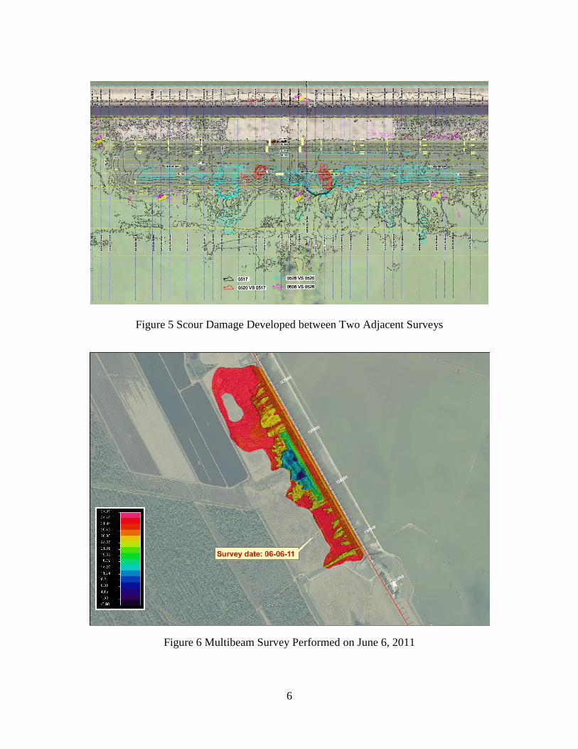
Contours plotted according to May 17, 2011 survey, and scour (elevation difference) contours
that developed between May 20, 2011 and May 17, 2011; May 26, 2011 and May 20, 2011; as
well as June 06, 2011 and May 26, 2011 are presented in Figure 5. Survey results concluded that
the tailbay terrain was changing continuously while the MCS was in operation. All surveys
showed that major scour areas were downstream of the plunge pool, especially at areas located
near two extruded corners.
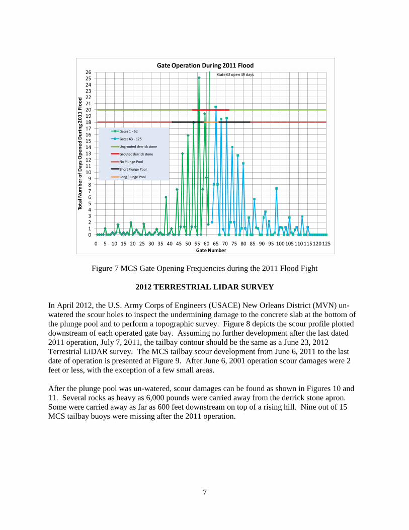
The multibeam survey performed on June 6, 2011 showed that scour holes were created at
almost all of the tailbay for a distance as far as 600 feet away from the structure. The worst
scour area was at the immediate downstream of the plunge pool, which had elevations lower than
10 feet NAVD88. At the plunge pool’s two extruded corners, elevations were close to 3 feet
NAVD88, which mean approximately 30 feet of ground earth was scoured away from its
location. Presented in Figure 6 is the survey performed on June 6, 2011.
The generated scour maps helped tremendously with gate operation exercise during the 2011
operation. Since the MCS middle gates faced plunge pool, the 2011 flood fight used middle
gates more frequently. The MCS gate opening frequencies during the 2011 flood fight are
presented in Figure 7.
6
Figure 5 Scour Damage Developed between Two Adjacent Surveys
Figure 6 Multibeam Survey Performed on June 6, 2011
7
Figure 7 MCS Gate Opening Frequencies during the 2011 Flood Fight
2012 TERRESTRIAL LIDAR SURVEY
In April 2012, the U.S. Army Corps of Engineers (USACE) New Orleans District (MVN) un-
watered the scour holes to inspect the undermining damage to the concrete slab at the bottom of
the plunge pool and to perform a topographic survey. Figure 8 depicts the scour profile plotted
downstream of each operated gate bay. Assuming no further development after the last dated
2011 operation, July 7, 2011, the tailbay contour should be the same as a June 23, 2012
Terrestrial LiDAR survey. The MCS tailbay scour development from June 6, 2011 to the last
date of operation is presented at Figure 9. After June 6, 2001 operation scour damages were 2
feet or less, with the exception of a few small areas.
After the plunge pool was un-watered, scour damages can be found as shown in Figures 10 and
11. Several rocks as heavy as 6,000 pounds were carried away from the derrick stone apron.
Some were carried away as far as 600 feet downstream on top of a rising hill. Nine out of 15
MCS tailbay buoys were missing after the 2011 operation.
0123456789
1011121314151617181920212223242526
0 5 10 15 20 25 30 35 40 45 50 55 60 65 70 75 80 85 90 95 100 105 110 115 120 125
Tota
l Nu
mb
er
of
Day
s O
pe
ne
d D
uri
ng
20
11
Flo
od
Gate Number
Gate Operation During 2011 Flood
Gates 1 - 62
Gates 63 - 125
Ungrouted derrick stone
Grouted derrick stone
No Plunge Pool
Short Plunge Pool
Long Plunge Pool
Gate 62 open 49 days

8
Figure 8 Scour Profile Downstream of Each Operated Gate Bay
Figure 9 Scour Damage Developed between June 6, 2011 & End of Operation
0
5
10
15
20
25
30
35
40
0 100 200 300 400 500 600 700 800
Ele
vati
on
, ft
NA
VD
88
(20
04.6
5)
Distance from End Sill, ft
XS25 Gate 43
XS26 Gate 46
XS27 Gate 49
XS28 Gate 52
XS29 Gate 55
XS30 Gate 58
XS31 Gate 61
XS32 Gate 64
XS33 Gate 67
XS34 Gate 71
XS35 Gate 74
XS36 Gate 77
XS37 Gate 80
XS38 Gate 83

9
Figure 10 Scoured MCS Tailbay after 2011 Operation
Figure 11 Scour Holes Downstream of the Plunge Pool’s Extruded Corners

10
MCS TAILBAY REPAIR
USACE’s Engineering & Research Development Center (ERDC) was asked to perform an
investigational study using a physical model as it is better than the numerical model for this type
of rehabilitation experiment. The investigation had four specific purposes: (1) to develop a scour
protection plan for the plunge pool gate bays (2) to develop a scour protection plan for the non-
plunge pool gate bays (3) to update the 1951 discharge rating curve to include a higher
headwater, actual crest design, and actual pier design information and (4) to use the study
findings to update the MCS gate operation sequence to reduce/eliminate the scour damage seen
in 1973 and 2011.
To meet the primary project goal of having the MCS fully repaired by the 2014 flood season, the
construction phase of the repair work was executed by the New Orleans District (MVN) in three
consecutive phases, each occurring upon completion of its respective physical model experiment.
The repair and construction materials (mainly riprap stone) were hauled from pre-approved
quarries along the upper Mississippi River via barges to an off loading site along the west bank
of the Mississippi River near the town of Morganza. The material strength, stability, slopes and
protection of critical sections replicated the conditions tested by the model. After 18 months of
repair and construction, successfully completed in March 2014, the MCS is now ready and
capable of passing the project flood.
Presented in Figure 12 is a MCS physical model in 1:22 scale. A MCS physical model with
plunge pool experiment is presented in Figure 13.
Figure 12 MCS Physical Model in 1:22 Scale

11
Figure 13 MCS Physical Model with Plunge Pool Experiment
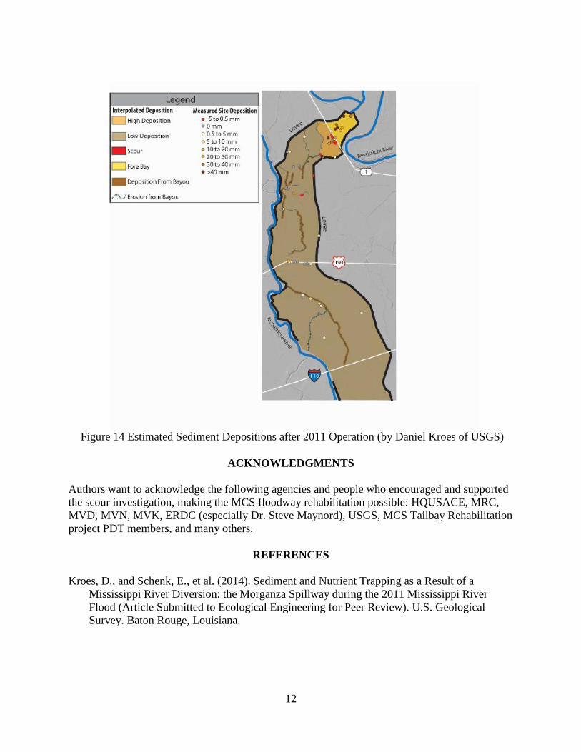
SEDIMENT DEPOSITION AFTER 2011 OPERATION
In May 2011, USGS performed a preliminary sediment deposition survey. Daniel Kroes et al.
(2014) found that an estimated 326,000 cubic yards of dense soil were scoured away
immediately downstream of the structure. The scoured soil became approximately 571,000
cubic yards of loose sediment and was deposited at least 30 miles from the MCS. If sediment
that was deposited in the forebay and the sediment that came through the structure are included,
the deposited sediment could be as high as 2 million cubic yards.
An estimated sediment distribution caused by the 2011 operation is presented in Figure 14.
CONCLUSIONS
Based on ERDC’s modeled results, three principle reasons caused the 2011 MCS tailbay
scouring: (1) little to no tailwater immediately behind the structure (2) benchmarked headwater
stage had been increased since the structure was constructed in 1954 and (3) only some of the
125 gates were used to pass the flood waters.
Lessons learned from both 1973 and 2011 operations and ERDC’s physical model experiment
are that tailwater conditions are critical for the stilling basin design and energy dissipation
calculation, operation needs to be maintained no more than the maximum headwater design
stage, and gate operations are extremely important to minimize and prevent tailbay scour.
12
Figure 14 Estimated Sediment Depositions after 2011 Operation (by Daniel Kroes of USGS)
ACKNOWLEDGMENTS
Authors want to acknowledge the following agencies and people who encouraged and supported
the scour investigation, making the MCS floodway rehabilitation possible: HQUSACE, MRC,
MVD, MVN, MVK, ERDC (especially Dr. Steve Maynord), USGS, MCS Tailbay Rehabilitation
project PDT members, and many others.
REFERENCES
Kroes, D., and Schenk, E., et al. (2014). Sediment and Nutrient Trapping as a Result of a
Mississippi River Diversion: the Morganza Spillway during the 2011 Mississippi River
Flood (Article Submitted to Ecological Engineering for Peer Review). U.S. Geological
Survey. Baton Rouge, Louisiana.