2010-11 SHPO Project Final Report Submitted: FINAL...
19
2010-11 SHPO Project Final Report West Virginia Civil War Conflict Sites and Areas GIS Map Page 1 of 19 Submitted: June 2011 FINAL REPORT Project Title: GIS Map of West Virginia Civil War Conflicts Contributors: Jessica L. Brewer, WVGISTC; Kurt Donaldson, WVGISTC Administration/Contact: Kurt Donaldson, Manager, WV GIS Technical Center, Department of Geology and Geography, West Virginia University, 330 Brooks Hall, P.O. Box 6300, Morgantown, WV 26506-6300, Phone: (304) 293-9467, Fax: (304) 293-6522, E-Mail: [email protected] , Web: http://wvgis.wvu.edu Collaborating Organization: WV State Historic Preservation Office (SHPO) PROJECT SUMMARY The GIS Map of West Virginia Civil War Conflicts compiles all known skirmishes, battles and conflict areas occurring throughout the state during the American Civil War. The West Virginia GIS Technical Center, under the purview of the West Virginia State Historic Preservation Office, researched and digitized point and polygon features that represent each of these conflict sites. There were 300 known skirmishes and battles between June 3, 1861 and April 1865. While the purpose of this project was to inventory and locate each site in order to more efficiently facilitate inquiries from the public, it is most importantly, a collection of comprehensive historical data that serves as the foundation for more extensive future projects. Ultimately, the map is the basis for preservation, education and awareness of a state that was a critical battleground, both figuratively and literally, during the Civil War. Each digitized feature was given attributes relative to the available historical data found during the course of research at West Virginia Regional History Collection, the West Virginia Division of Culture and History State Archives, the Official Records of the War of the Rebellion, various primary and secondary battle maps and atlases, and other primary and secondary source material. Each source used as references for the project has been documented in Appendix A. PROJECT HIGHLIGHTS The issues surrounding the Civil War were critical in the formation of the state on June 20, 1863, as was the course of the war transversely impacted by its creation. The first land battle of the Civil War was at Philippi, West Virginia and the Baltimore and Ohio Railroad, the most contested and sought-after artery of transportation during the war, not only was the cause and site of numerous conflicts between the north and south, but was the reason behind much of the state’s unique shape. There were several major operational campaigns of which significant portions were fought in West Virginia. Some battles lasted for days, while others a few short hours, yet all had a lasting impact on the outcome of the war. Some cities like Martinsburg and Romney changed hands dozens of times and
-
Upload
vuongtuong -
Category
Documents
-
view
222 -
download
1
Transcript of 2010-11 SHPO Project Final Report Submitted: FINAL...

2010-11 SHPO Project Final Report West Virginia Civil War Conflict Sites and Areas GIS Map
Page 1 of 19
Submitted: June 2011
FINAL REPORT
Project Title: GIS Map of West Virginia Civil War Conflicts
Contributors: Jessica L. Brewer, WVGISTC; Kurt Donaldson, WVGISTC
Administration/Contact: Kurt Donaldson, Manager, WV GIS Technical Center, Department of Geology
and Geography, West Virginia University, 330 Brooks Hall, P.O. Box 6300, Morgantown, WV 26506-6300,
Phone: (304) 293-9467, Fax: (304) 293-6522, E-Mail: [email protected] , Web:
http://wvgis.wvu.edu
Collaborating Organization: WV State Historic Preservation Office (SHPO)
PROJECT SUMMARY
The GIS Map of West Virginia Civil War Conflicts compiles all known skirmishes, battles and conflict
areas occurring throughout the state during the American Civil War. The West Virginia GIS Technical
Center, under the purview of the West Virginia State Historic Preservation Office, researched and
digitized point and polygon features that represent each of these conflict sites. There were 300 known
skirmishes and battles between June 3, 1861 and April 1865. While the purpose of this project was to
inventory and locate each site in order to more efficiently facilitate inquiries from the public, it is most
importantly, a collection of comprehensive historical data that serves as the foundation for more
extensive future projects. Ultimately, the map is the basis for preservation, education and awareness of
a state that was a critical battleground, both figuratively and literally, during the Civil War.
Each digitized feature was given attributes relative to the available historical data found during the
course of research at West Virginia Regional History Collection, the West Virginia Division of Culture and
History State Archives, the Official Records of the War of the Rebellion, various primary and secondary
battle maps and atlases, and other primary and secondary source material. Each source used as
references for the project has been documented in Appendix A.
PROJECT HIGHLIGHTS
The issues surrounding the Civil War were critical in the formation of the state on June 20, 1863, as was
the course of the war transversely impacted by its creation. The first land battle of the Civil War was at
Philippi, West Virginia and the Baltimore and Ohio Railroad, the most contested and sought-after artery
of transportation during the war, not only was the cause and site of numerous conflicts between the
north and south, but was the reason behind much of the state’s unique shape.
There were several major operational campaigns of which significant portions were fought in West
Virginia. Some battles lasted for days, while others a few short hours, yet all had a lasting impact on the
outcome of the war. Some cities like Martinsburg and Romney changed hands dozens of times and

2010-11 SHPO Project Final Report West Virginia Civil War Conflict Sites and Areas GIS Map
Page 2 of 19
were the sites of numerous conflicts. Yet other parts of the state, as in the northern panhandle,
escaped the destruction caused by battles during the war. As a result, it was at times difficult to
pinpoint exact locations of the battles. In truth, much of the state was traversed in one way or another
by Confederate and Union armies, and creating stringent boundaries proved to be problematic.
Ultimately, the boundaries created for each site and area represent the interpretation of the researcher
after collecting in-depth data from multiple sources.
Most accounts of the battles were taken from The Official Records of the War of the Rebellion, a
compilation of primary source data in the form of letters, telegrams, orders and maps written by the
officers leading both the Union and Confederate armies. These accounts described the action occurring
during the war, some very detailed, as in the case of much of the Gauley River area and Eastern
Panhandle. They were used in conjunction with Civil War era atlases and map sketches. Once a location
was obtained for each conflict site, it was compared with USGS topographical maps and 2009 NAIP
orthophotographic imagery in order to position each point as accurately as possible. If a definitive
location could not be established, a polygonal area was digitized that most closely represented all
known landmarks and features detailed in the battle accounts.
There were two files created for the project: a point shapefile and a polygon shapefile. While the point
shapefile contains an individual point for every known battle/skirmish site, the polygon file identifies the
area and extent of action given the information available via the Official Records of the War of the
Rebellion, other correspondence, atlases, and any additional primary source material. The following
table summarizes the features created during the project:
Battle/Skirmish Features
Points 300
Polygons 51
Total Features Digitized 351
PROCESS
Identification
The first step in the process was to identify the conflict events that occurred in West Virginia. Each
conflict was labeled skirmish, battle, engagement, expedition or affair. According to
www.civilwarhome.com a skirmish was a “limited combat, involving troops other than those of the
main body” and an engagement, affair or battle was a conflict where the main body was involved as
well. While this definition is limited and somewhat subjective, it generally identifies skirmishes as
those small conflicts occurring throughout the war between small groups of soldiers, whereas a
battle, affair or engagement was a major action taking place between a large group or several
troops of soldiers.

2010-11 SHPO Project Final Report West Virginia Civil War Conflict Sites and Areas GIS Map
Page 3 of 19
Approximately a third of the conflicts during the Civil War in West Virginia were “Affairs”, “Actions”
or “Engagements”, while the “Skirmishes” numbered several hundred. Some of these skirmishes
were decidedly more significant than others, often becoming turning points for the North and the
South. For example, the April 26, 1863 skirmishes at Rowlesburg, lasting but a few hours, and by all
accounts should have probably been a southern victory, were by, cunning, strategy and a little bit of
luck significant victories for the Union in that they prevented a costly and devastating destruction of
the Baltimore and Ohio Railroad, an important line that supplied troops and supplies to western
areas.
Verification and Validation
The initial data for the project was supplied by the State Historic Preservation Office and then
verified by the West Virginia GIS Technical Center through extensive historical research. Initially
each battle/skirmish was researched in secondary sources, such as National Geographic’s Atlas of
the Civil War and various internet sources, including local and county historical societies, the
National Park Service, and the National Battlefield Protection Program. For a complete list of
sources, please see Appendix A.
The SHPO master list of battle/skirmishes contained the city, date of the event and identified each
event as a skirmish, affair, engagement or expedition. With this information, a general search of
information was implemented, of which the most significant and well-known battles, such as
Harpers Ferry, Charles Town, Martinsburg, Fayetteville, Romney, and Princeton returned multiple
sources that detailed most components of event. The greatest difficulty in sorting the information
for each battle/skirmish was in isolating the minor skirmishes for each site. For instance, Harpers
Ferry experienced some type of conflict, officially, at least 12 times during the Civil War, and for the
most part, the destruction of the armory, bridges, and the battles near Boliver and Maryland Heights
are detailed in most accounts. There is little mention of the other 8 minor conflicts, and ultimately
the only reference to them was often in The Official Records of the War of the Rebellion, and even
then, there was perhaps a single line that stated that it occurred on a particular date and who the
commanding officers were in the skirmish. For a list of features in which limited information existed
and how they were identified, see Appendix C. If a skirmish could not be identified after all sources
were consulted, then it was not digitized. For a list of non-digitized, but SHPO supplied sites, see
Appendix C.
The SHPO master list of events was populated from multiple sources (according to the SHPO
representative), and as a result contains a number of duplicate sites under various or alternate
names, making it difficult at times to identify the event during the research process. For example,
Harpers Ferry and Bolivar Heights were listed as separate events occurring in Harpers Ferry and
Bolivar Heights, when in one case, this was the same event, although the “event” took place over a
wide area (downtown Harpers Ferry area and Bolivar Heights area, see figure 1).

2010-11 SHPO Project Final Report West Virginia Civil War Conflict Sites and Areas GIS Map
Page 4 of 19
It was through careful research and an extensive
comparison process, that any possible duplicate
features were identified correctly. Great care was
taken in ensuring that both events were not double or
even triple listed and that events were not left out
merely because they were in close proximity and
shared the same date with another event. The
primary methodology for ascertaining the validity of
the features was its presence in The Official Records of
the War of the Rebellion. If the skirmish/battle was
specifically listed in The Official Records of the War of the Rebellion, then it was included. A field
was created in the final shapefile that includes any alternate names for each battle/skirmish. The
primary name used for the battle was selected based on its reference in The Official Records of the
War of the Rebellion. For a complete list of duplicate events, see Appendix C.
After removing duplicate entries in the SHPO master list,
a search was completed for additional skirmishes
occurring in the state that may have not been included.
Again, not only are there over 300 known
battle/skirmish sites in the state, but there were in all
likelihood a number of undocumented ones, making it
difficult to compile a fully comprehensive list.
Whenever events were not included, but verifiably
occurred, they were added to the dataset. It is quite
possible that as the map is reviewed, sites still may need
to be added based on additional research, local
knowledge and suggestions from the users. For a list of
added features see Appendix C.
A final master list was created which served as the
primary inventory utilized in the project. After
completing a general search for data in secondary
sources, which essentially provided supplementary and
foundational information that aided in primary source
research, each battle/skirmish was researched
individually in The Official Records of the War of the
Rebellion, military correspondence, and maps /atlases
housed at various institutions, including the Library of Congress American Memory Digital Map
Collection and The David Rumsey Collection (see example figure 2). For a complete list of sources
and websites consulted, please see Appendix A.
Figure 1
Figure 2

2010-11 SHPO Project Final Report West Virginia Civil War Conflict Sites and Areas GIS Map
Page 5 of 19
Digitization
Every event digitized was done so only when primary research material
supported its existence. Each of these references is contained within an
attribute field in the point shapefile. Given that the bibliographic
information for each source was extensive, a key was developed to
identify them. A key to the sources is provided in both this report in
Appendix A and the metadata associated with the shapefile.
After the research process was complete, each event was digitized in a point shapefile [see figure 3].
Given that the battles/skirmishes did not only occur at a specific point, each digitized point is a
representation of the location of the battle, set at approximately the center of the area in which the
event took place. To supplement the point shapefile, a polygon shapefile was created that
incorporated each point and the approximate area, according to the completed research, that the
conflict took place [see figure 3]. It should be noted that these areas are somewhat subjective in
that they are based on the descriptions provided by the primary source
materials and are interpretations thereof.
Each digitized point was located spatially with the aid of USGS
topographic maps and 2009 NAIP orthophotographic imagery [see
figures 4 & 5]. These resources were most helpful when locating points
relative to descriptive information in the primary sources that indicated
battle/skirmish sites at a specific creek, road, mountain or
other recognizable landmark. The primary purpose for
utilizing these resources was to ensure accuracy in the
placement of points.
Once each point was digitized, the attribute fields were
populated. For a complete list of fields, see Appendix B. In
that extensive research was completed during the project
which yielded a wealth of information, additional fields
were created beyond those required. The goal was to
provide a foundation for later use by utilizing all collected
data, rather than only that which was required by SHPO.
See Appendix B for these additional fields.
DELIVERABLES
Point shapefile with each battle/skirmish digitized
Polygon shapefile with battle/skirmish areas digitized
Project final report
Bibliography and links to sources
Figure 5
Figure 3
Figure 4

2010-11 SHPO Project Final Report West Virginia Civil War Conflict Sites and Areas GIS Map
Page 6 of 19
CHALLENGES
During the project, several issues surfaced that should be noted when reviewing the final product.
Duplicates and Alternate Names
There were 20 battle/skirmishes provided by the SHPO master list that were listed twice and in a
couple of cases, three times under different names. Often, battles/skirmishes were fought in areas
in which military officials may have been unfamiliar with the local colloquialisms. This, tethered
with the reality that they were fought over several miles, skirmishing along routes for extended
stretches, made it difficult to definitively label each conflict with one single name. Where possible,
duplicates were removed, and features were given the most common or well-known name as it is
referred to in official correspondence. Alternate names were included in a separate field in order to
facilitate the search process. One example of this is the Battle of Laurel Hill in Barbour County on
July 7-12, 1861, which was also listed as “Belington”, the town to which Laurel Hill is adjacent. The
battle, in most records is referred to as Laurel Hill, but “Belington” is listed as an alternate name.
See Appendix C for a complete list and descriptions of each of these duplicates.
In addition to duplicates, some events contain alternate names or spellings across a number of
sources. For example, Corrick’s Ford in Tucker County was a significant skirmish in 1861, but even
The Official Records of the War of the Rebellion refer to it as “Carrick’s Ford” in some instances. As a
result any alternate spellings or names found in the course of the research have been included in
the shapefile.
Incorrect, Unverifiable or Inconsistent Dates
While each of the events in the SHPO master list contained a date field, in some instances the dates
did not match up with the research. For example, the first battle of Harpers Ferry [destruction of
the bridge] was in June 1861, but the SHPO master list identified it as being July 4, 1861. All
consulted sources identified the correct date as June 1861. In some of these cases, it was difficult to
ascertain whether the information from SHPO was incorrect or if it was based on information
missed by the researcher. Ultimately, The Official Records of the War of the Rebellion were used as
the deciding force, and if the battle was listed or mentioned in the records, then it was digitized, but
if it could not be found after extensive research, it was flagged and was not included. For a
complete list of these events, see Appendix C.
Each digitized point and polygon was created based on locations and descriptions yielded from
research in primary and secondary sources. It should be noted that some events were described in
great detail in the The Official Records of the War of the Rebellion and/or were documented on
period atlases and maps, while others were not. In the case that the event was well-documented,
the precision with which the points and polygons were located was higher. However, several
battle/skirmish sites lacked details and limited maps exist beyond major conflicts which introduces a
certain factor of error. In addition, without intimate local knowledge, it is difficult to ascertain the
exact location of landmarks detailed in the sources.

2010-11 SHPO Project Final Report West Virginia Civil War Conflict Sites and Areas GIS Map
Page 7 of 19
FUTURE DIRECTIONS
The GIS map of West Virginia Civil War Conflicts has the potential to be a catalyst for further education,
preservation and awareness about a the most significant period in West Virginia history. It is the
foundation upon which greater, more in depth projects can be based on. In itself, it is an invaluable
resource to both public and private sectors and the data collected for the project can be used in a
number of ways, but in particular it is an instrument that can be used for education and preservation.
Increasingly, historical data and maps have been made available via the internet. Using the
technological, in this case GIS, to further experience the qualitative (the human side) of cultural
resources is becoming increasingly possible and valuable. For example, The Valley of the Shadow: Two
Communities in the Civil War (www.valley.lib.virginia.edu), a site that relates the story of two Civil War
towns, one Union and the other Confederate, in Virginia, engages the user by providing links to primary
source materials and creates another dimension to a historical event, taking it beyond the written word.
The GIS map of West Virginia Civil War Conflicts has the potential as a multimedia application. Creating
layers on the GIS map application by geo-referencing historical maps and linking other images, archival
records, diaries and websites help to integrate primary source data with technology. Through both
turning on and off layers and adjusting the opacity, battles and campaigns occurring within the state are
given spatial context and become comparable to modern maps and aerial imagery.
In addition, there is an extensive amount of data associated with each shapefile. As a result, additional
attribute fields to further enhance the application are suggested. Battles/skirmishes could be
designated as Union or Confederate victories. Significant persons could be identified that were
associated with the battles/skirmishes. Last, the campaigns with which the battles/skirmishes were a
part could be identified on the map, leading to the digitization of troop movement over the course of
the war and giving context as to the sequence of events.
West Virginia played a critical role during the Civil War and while the major conflicts like Harpers Ferry,
Fayetteville, Princeton, Romney, Charles Town and Martinsburg are remembered and documented,
there are many small skirmish sites that were crucial links between the greater battles. The GIS map of
West Virginia Civil War Conflicts inventories these sites and has the potential to create resources that
will highlight the importance of all conflicts in the state. Most people do not realize that there were
over 300 skirmishes and battles in the state. Much of the state was a battlefield, and while every site
cannot be preserved or even publicly identified, they are still a critical part of the history of West
Virginia. Ultimately, building on the foundation of the data produced in this project increases awareness
that educates as well as preserve the state’s vast cultural heritage.

2010-11 SHPO Project Final Report West Virginia Civil War Conflict Sites and Areas GIS Map
Page 8 of 19
APPENDIX A: Sources and Bibliography
Within the scope of this project, an emphasis was placed on the use of primary source materials
whenever possible. In most cases, secondary sources, such as various Civil War History books and
websites were first consulted in order to solicit details, which were then used in primary source
searches. All digitized sites and areas have an Official War of the Rebellion Records reference in that it is
considered the definitive source for first hand Civil War data. In addition, each site, when possible has
also one or more additional primary and secondary source references whenever possible. To simplify
the references in the shapefile, abbreviations were used, followed by reference details (volume,
chapter, series, page, etc.).
TABLE A-1: Types of Sources
Bibliographic Source
Source Abbreviation
Example
Digital Map DM DM[ImageNumber] DMlva0098
See Table A-3
Official Records of the War of the Rebellion
RR RR[Series][Volume][Part][Chapter][Page] RRS1V5P1CH2P345
See Shapefile Report
Book B B [Author Last Name][Page] BLEWIS56
See Table A-4
Official Records of the War of the Rebellion Atlas
RRATLAS RRATLAS[Plate No.] RRATLAS69
See Table A-3
TABLE A-2: Web Sources
Bibliographic Sources Location or Link
West Virginia Online Encyclopedia www.wvencyclopedia.org
www.americancivilwar.com www.americancivilwar.com
http://www.americanwars101.com/civilwar.html
http://www.americanwars101.com/civilwar.html
West Virginia Department of Commerce www.wvcommerce.org
Department of Culture and History Civil War Online Archives
http://www.wvculture.org/history/civilwar.html
The National Park Service: The American Battlefield Protection Program
http://www.nps.gov/hps/abpp/battles/bystate.htm#wv
Shepherdstown Battlefield Protection Association Inc.
www.battleofshepherdstown.org
The Civil War Trust www.civilwar.org
The Jefferson County Historical Society http://jeffersonhistoricalwv.org/CWmarkers.html#12
The National Park Service: Harpers Ferry National Historical Park
http://www.nps.gov/hafe/index.htm
Historical Marker Database www.hmdb.org

2010-11 SHPO Project Final Report West Virginia Civil War Conflict Sites and Areas GIS Map
Page 9 of 19
Bibliographic Sources Location or Link
Civilwartraveler.com www.civilwartraveler.com
The Battle of Dry Creek www.battleofdrycreek.com
Battle of Lewisburg www.battleoflewisburg.org
The Civil War Archive http://www.civilwararchive.com/
Guyandotte Civil War Days http://www.guyandottecivilwardays.com/
Civil War Landscapes www.civilwarlandscapes.org
West Virginia in the Civil War Sesquicentennial
http://www.civilwar150.wv.gov/Pages/default.aspx
The Battle of Rich Mountain www.battleofrichmountain.org

2010-11 SHPO Project Final Report West Virginia Civil War Conflict Sites and Areas GIS Map
Page 10 of 19
TABLE A-3: Map Sources
The Civil War era maps used as primary sources for this project can be found at the Library of Congress
Geography and Map Reading Room [http://www.loc.gov/rr/geogmap/guides.html] and as plates
appended to The Official Records of the War of the Rebellion. The location or link of those maps from
the Library of Congress is preceded by the accession number. Given that many of the maps in the
Library of Congress collection have unknown authors and/or questionable dates, the reference
abbreviation used is “DM” followed by the image number provided by the Library of Congress as a part
of their collection.
Title Abbreviation Author; Year Location or Link
Berkeley County, VA: 1861 DMlva00082 Col. J.N. Macomb http://hdl.loc.gov/loc.ndlpcoop/glva01.lva00082
Map shewing [sic] vicinity of Harper's Ferry, Virginia, and the upper Potomac River.
DMvhs00045 Sneden, Robert Knox; 1861-65
gvhs01 vhs00045 http://hdl.loc.gov/loc.ndlpcoop/g
vhs01.vhs00045
Map shewing [sic] movements of Union and Rebel armies from 30th June to 13th July 1863.
DMvhs00047 Sneden, Robert Knox; 1861-65
gvhs01 vhs00047 http://hdl.loc.gov/loc.ndlpcoop/gvhs01.vhs00047
Map of part of Pocahontas, Randolph, and Webster counties, West Virginia
DMcws00179 1865 g3893p cws00179 http://hdl.loc.gov/loc.gmd/g3893p.cws00179
Sketch of the region west of Charlestown, West Virginia, showing fortifications
DMcwh00184 1864 g3894c cwh00184 http://hdl.loc.gov/loc.gmd/g3894c.cwh00184
Map of Raleigh, Mercer and Summers Counties, West Virginia / prepared by residents of western Virginia for General Loring
DMlva00131 1862 glva01 lva00131 http://hdl.loc.gov/loc.ndlpcoop/glva01.lva00131
Sketch of western Virginia and eastern West Virginia, between Staunton and Clarksburg
DMcwh00066 1861 g3884s cwh00066 http://hdl.loc.gov/loc.gmd/g3884s.cwh00066
Military reconnaissance in the vicinity of Gauley Bridge, Department of western Virginia, Brig. Genl. W. S. Rosecrans, comd'g., Sept. 11th to Nov. 15, 1861 By W. F. Raynolds, Capt. Top. Engr's., W. Margedant, O. V. [and] W. Angelo Powell, C. Engr. Published by authority of the
DMcw0695000 Raynolds, W. F. (William Franklin), Office of the Chief of Engineers, U.S. Army; 1879
g3894g cw0695000 http://hdl.loc.gov/loc.gmd/g3894g.cw0695000

2010-11 SHPO Project Final Report West Virginia Civil War Conflict Sites and Areas GIS Map
Page 11 of 19
Title Abbreviation Author; Year Location or Link
Hon. the Secretary of War in the office of the Chief of Engineers, U.S. Army
Map of portions of Hampshire and Mineral Counties, W. Va., and Garrett County, Md
DMcwh00068 1861 g3893h cwh00068 http://hdl.loc.gov/loc.gmd/g3893h.cwh00068
Pencil sketch of the road from Slaven's Cabin to the top of Cheat Mountain in the area of the battle of Rich Mountain, July 11-12, 1861
DMcwh00081 Unknown g3892r cwh00081 http://hdl.loc.gov/loc.gmd/g3892r.cwh00081
Vicinity of Harpers Ferry DMcwh00192 1864 g3894h cwh00192 http://hdl.loc.gov/loc.gmd/g3894h.cwh00192
Two sketches on one sheet of the road from Huntersville, W. Va. along Knap Creek to the Greenbrier River, and from the Greenbrier River across Brushy Ridge
DMcwh00079 1861 g3894h cwh00079 http://hdl.loc.gov/loc.gmd/g3894h.cwh00079
Map of Wyoming, Fayette and Raleigh Counties, West Va. / prepared by residents of 1862western Virginia for Gen. Loring
DMlva00135 Unknown glva01 lva00135 http://hdl.loc.gov/loc.ndlpcoop/glva01.lva00135
Map of part of eastern West Virginia, extending from Romney westward to Clarksburg, centering on the Rich Mountain Battle area
DMcwh00067 1861 g3892r cwh00067 http://hdl.loc.gov/loc.gmd/g3892r.cwh00067
Map of the battle field of Carnifex Ferry, Gauley River, West Va., Sept. 10th 1861. United States forces commanded by Brig. Gen. W. S. Rosecrans Published by authority of the Hon. the Secretary of War.
DMcw694000 1876 g3894m cw0694000 http://hdl.loc.gov/loc.gmd/g3894m.cw0694000
Map of Greenbrier, Summers, Raleigh, Mercer and Monroe Counties, West Va. and Bland, Giles and Craig Counties, Va. / prepared by residents for General Loring
DMlva00134 1862 glva01 lva00134 http://hdl.loc.gov/loc.ndlpcoop/glva01.lva00134
Averill's map of western Va DMcwh00069 1861 g3892r cwh00069 http://hdl.loc.gov/loc.gmd/g3892r.cwh00069

2010-11 SHPO Project Final Report West Virginia Civil War Conflict Sites and Areas GIS Map
Page 12 of 19
Title Abbreviation Author; Year Location or Link
The attack on Harper's Ferry Va., by Jackson, September 14th and 15th, 1862.
DMvhs00296 Sneden, Robert Knox; 1862-65
gvhs01 vhs00296 http://hdl.loc.gov/loc.ndlpcoop/gvhs01.vhs00296
Plan of the Battle of Carnifex Ferry, West Virginia.
DMvhs00280 Sneden, Robert Knox; 1861-65
gvhs01 vhs00280 http://hdl.loc.gov/loc.ndlpcoop/gvhs01.vhs00280
Map of Jefferson County, Va. photographed for the Bureau of Topographical Engineers Oct., 1862
DMlva00085 1862 glva01 lva00085 http://hdl.loc.gov/loc.ndlpcoop/glva01.lva00085
Map of a part of Greenbrier County, West Va. / prepared by residents for General Loring
DMlva00137 1862 glva01 lva00137 http://hdl.loc.gov/loc.ndlpcoop/glva01.lva00137
Hunter's victory at Mount Crawford [October 2, 1864]. Scene of the operations in Shenadoah Valley-capture of Staunton
DMcw0654800 1864 g3882s cw0654800 http://hdl.loc.gov/loc.gmd/g3882s.cw0654800
Map of parts of Highland County, Va., and Pendleton County, W. Va
DMcwh00082 1861 g3883h cwh00082 http://hdl.loc.gov/loc.gmd/g3883h.cwh00082
Map of the battle ground of Greenbrier River
DMcw0697000 McRae, A. T.; 1861
g3892g cw0697000 http://hdl.loc.gov/loc.gmd/g3892g.cw0697000
The attack on and surrender of Harper's Ferry
DMvhs00112 Sneden, Robert Knox; 1862-65
gvhs01 vhs00112 http://hdl.loc.gov/loc.ndlpcoop/gvhs01.vhs00112
Military map showing the topographical features of the country adjacent to Harper's Ferry, Va.; including Maryland, Loudoun, and Bolivar Heights, and portions of South and Short Mountains, with the positions of the defensive works, also the junction of the Potomac & Shenandoah Rivers, and their passage through the Blue Ridge / Surveyed from August 3d to Sept. 20th 1863, under the direction of Capt. N. Michler, Corps of Engrs., U.S. Army
DMcw0699000 Major John E. Weyss ;1863
g3894h cw0699000 http://hdl.loc.gov/loc.gmd/g3894h.cw0699000
2010-11 SHPO Project Final Report West Virginia Civil War Conflict Sites and Areas GIS Map
Page 13 of 19
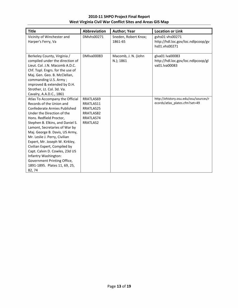
Title Abbreviation Author; Year Location or Link
Vicinity of Winchester and Harper's Ferry, Va
DMvhs00271 Sneden, Robert Knox; 1861-65
gvhs01 vhs00271 http://hdl.loc.gov/loc.ndlpcoop/gvhs01.vhs00271
Berkeley County, Virginia / compiled under the direction of Lieut. Col. J.N. Macomb A.D.C. Chf. Topl. Engrs. for the use of Maj. Gen. Geo. B. McClellan, commanding U.S. Army ; improved & extended by D.H. Strother, Lt. Col. 3d. Va. Cavalry, A.A.D.C., 1861
DMlva00083 Macomb, J. N. (John N.); 1861
glva01 lva00083 http://hdl.loc.gov/loc.ndlpcoop/glva01.lva00083
Atlas To Accompany the Official Records of the Union and Confederate Armies Published Under the Direction of the Hons. Redfield Proctor, Stephen B. Elkins, and Daniel S. Lamont, Secretaries of War by Maj. George B. Davis, US Army, Mr. Leslie J. Perry, Civilian Expert, Mr. Joseph W. Kirkley, Civilian Expert, Compiled by Capt. Calvin D. Cowles, 23d US Infantry Washington: Government Printing Office, 1891-1895. Plates 11, 69, 25, 82, 74
RRATLAS69 RRATLAS11 RRATLAS25 RRATLAS82 RRATLAS74 RRATLAS2
http://ehistory.osu.edu/osu/sources/records/atlas_plates.cfm?set=49

2010-11 SHPO Project Final Report West Virginia Civil War Conflict Sites and Areas GIS Map
Page 14 of 19
TABLE A-4: Book Sources
Title Abbreviation Author Publication
The Civil War Battlefield Guide
BKennedy Kennedy, Frances H. Houghton Mifflin, 1998
Atlas of the Civil War: A Complete Guide to the Tactics and Terrain of Battle (National Geographic)
BHyslop Hyslop, Stephen National Geographic, 2009
A History of Pendleton County West Virginia
BMorton Morton, Oren F. Ruebush-Elkins, 1910
History of Hampshire County West Virginia From its Earliest Settlement to the Present
BMaxwellHamp Maxwell, Hu A. Brown Boughner, 1897
History of Harrison County from the Early Days of the Northwestern Railroad to the Present
BHaymond Haymond, Henry Acme Publishing, 1910
History of Tucker County, West Virginia From the Earliest Explorations and Settlements to its Present Time
BMaxwellTuck Maxwell, Hu Preston Publishing, 1884

2010-11 SHPO Project Final Report West Virginia Civil War Conflict Sites and Areas GIS Map
Page 15 of 19
APPENDIX B: Attribute Fields
While certain fields were required by the State Historic Preservation Office, other relative attribute
fields were included that created a more comprehensive shapefile. Included within the attribute fields is
the primary reference in which one can consult for further information about the battle or skirmish.
TABLE B-1: Point and Polygon Shapefile Fields
Attribute Field Description Required
FID Internal field for shapefile N/A
Shape Internal field for shapefile. Indicates whether the digitized feature is a point or polygon
N/A
Id Internal feature Id assigned to each point N/A
Conflict Site Name of battle, skirmish, affair, engagement, or expedition for which the point has been digitized
Y
Alt_Name Any alternate names or spelling for the battle/skirmish. Multiple names are separated by a semicolon.
N
City The primary city to which the point is closest in proximity. This field is somewhat subjective, but will provide for a better search and analysis process.
N
County The primary county in which the digitized point is located Y
State In all cases this field is WV
Month The primary month in which the battle took place. Date is separated into Month/Day/Year fields to simplify analysis at a later date if desired. It is able to be sorted and searched by month, day or year.
N
Day The primary date or dates for which the battle/skirmish was fought. Multiple dates are separated by a hyphen.
N
Year The primary year in which the battle took place N
Date Date of the conflict in MM/DD/YYYY format Y
Primary Source The primary source document [see table A-1 for types and abbreviations] for the battle/skirmish.
Y
Conflict Type Indicates battle, skirmish, affair, engagement or expedition N
Lat_Dec The decimal latitude for the digitized point. Y
Long_Dec The decimal longitude for the digitized point Y
Private Indicates whether site is on public or private lands N
Restricted Indicates whether the information associated with the point is restricted from the general public
N

2010-11 SHPO Project Final Report West Virginia Civil War Conflict Sites and Areas GIS Map
Page 16 of 19
APPENDIX C: Issues for Individual Events
TABLE C-1: Duplicate Events
Duplicate Events Official Name Alternate Names Source
Belington (7/7-12/1861) Laurel Hill
Laurel Hill Belington RRS1V2P1CHIXP216-218
Blue’s Gap (10/4/1862) Hanging Rock
Blue’s Gap Hanging Rock RRS1V19P2CHXXXIP16-25
Burlington (4/6/1863) Purgitsville
Burlington Purgitsville RRS1V25P1CHXXXVIIP81
Hedgesville (7/18-19/1863) Martinsburg
Martinsburg Hedgesville
Moorefield (9/4/1863) Petersburg Gap
Petersburg Gap Moorefield RRS1V29P1CHXLIP102
Blue Sulphur Road (12/14/1863) Meadow Bluff
Meadow Bluff Blue Sulphur Road RRS1V29P1CHXLIP940
Springfield (6/26/1864) Wire Bridge
Wire Bridge Springfield RRS1V37P1CHXLIXP356
Moorefield (8/7/1864) Oldfields
Oldfields Moorefield RRS1V43P1CHLVP724-26
Welch’s Springs (8/21/1864) Middleway Flowing Springs
Welch’s Springs Middleway Flowing Springs
RRS1V43P1CHLVP19-22
Springfield; Hanging Rock Pass (10/26//1861)
Springfield Hanging Rock Pass RRS1V5P1CHXIVP378-79
Fayetteville (11/12/1861) Laurel Creek Layral Creek
Laurel Creek
Layrel Creek Fayetteville
RRS1V5P1CHXIVP283
Cross-Lanes Kesslers Cross Lanes Cross-lanes RRS1V5P1CHXIVP118
TABLE C-2: Events with Multiple Spellings and/or Alternate Names
Events Official Name Alternate Names Source
Corrick’s Ford
Corrick’s Ford Carrick’s Ford RRS1V5P1CHXIVP378-79
Cross-Lanes Kesslers Cross Lanes Cross-lanes RRS1V5P1CHXIVP118
Fayetteville (11/12/1861)
Laurel Creek
Layrel Creek Fayetteville
RRS1V5P1CHXIVP283
Gauley Bridge (11/1-3/1861 Cotton Hill Cotton Hill RRS1V5P1CHXIVP250

2010-11 SHPO Project Final Report West Virginia Civil War Conflict Sites and Areas GIS Map
Page 17 of 19
TABLE C-3: Unverified Events
Unverified Events Date Reason
Shanghai 7/16/1863 Insufficient sources to verify exact location of this skirmish
Flat Top Mountain 7/27/1862 The SHPO list indicated that this skirmish is in Berkeley County, but references and maps identify Flat Top Mountain in Mercer County. Are there two?
South Fork (Potomac River) 11/9/1862 Insufficient sources to verify exact location of this skirmish
Clark’s Hollow 5/1/1862 Insufficient sources to verify exact location of this skirmish
West Fork 6/10/1862 Insufficient sources to verify exact location of this skirmish
Black Creek Bridge 7/27/1864 Unable to find this skirmish in references. Possibly “Back Creek Bridge”?
Loup Creek 6/26/1863 SHPO list indicates that it is in Braxton County, but Loup Creek or Loop Creek on the same day and referenced in the Official Records and on maps is in Fayette County
Cheat Mountain 9/11-17-1861 Cheat Mountain consisted of skirmishes at Cheat Mountain Pass, Cheat Summit, Elk Water and Point Mountain** Turnpike, there for each individual event was digitized and a polygon was created that encompassed all features, but a point feature was not solely made for Cheat Mountain.

2010-11 SHPO Project Final Report West Virginia Civil War Conflict Sites and Areas GIS Map
Page 18 of 19
TABLE C-4: Additional Events
Additional Events Date Bibliographic Source
Droop Mountain 11/6/1863 http://www.droopmountainbattlefield.com/; http://www.nps.gov/hps/abpp/battles/wv012.htm
Damn No. 5 C&O Canal, Falling Water
12/8/1861 RRS1V5P1CHXIVP3
Carnifex Ferry 9/10/1861 http://www.carnifexferrybattlefieldstatepark.com/; http://www.wvculture.org/history/civilwar/carnifex01.html S1V5P1CHXIVP122-65
Hoke’s Run (Falling Water Hainesville)
12/20 http://www.nps.gov/hps/abpp/battles/wv004.htm
Bowman’s Place 7/15/1861 S1V2P1CHIXP2
Righter 6/23/1861 S1V2P1CHIXP2
Romney 6/13/1861 S1V2P1CHIXP123-124
Hedgesville; Spring Mills Road; Hoke’s Run
6/30/1861 S1V2P1CHIXP160-181
Red House; Barboursville
7/13/1861 S1V2P1CHIXP193
Piggot’s Mill; Big Run
8/25/1861 S1V5P1CHXIV
Blue’s House 8/26/1861 S1V5P1CHXIV
Wayne County Court House
8/26-27-1861 S1V5P1CHXIV
Blue Creek 9/1/1861 S1V5P1CHXIV
Boone County Court House
9/1/1861 S1V5P1CHXIV
Hawk’s Nest; Turkey Creek
9/2/1861 S1V5P1CHXIVP122-123
Beller’s Mill; Harpers Ferry
9/2/1861 S1V5P1CHXIV
Beckley Courthouse 12/28/1861 S1V5P1CHXIV
Cherry Run 12/25/1861 S1V5P1CHXIV
Bath 1/3-4/1862 S1V5P1CHXIV
Dry Fork of Great River
1/8/1862 S1V5P1CHXIV
Mouth of Blue Stone
2/8/1861 S1V5P1CHXIV
Affair at Roane County
12/15/1861 S1V5P1CHXIV
Elkwater 9/12/1861 S1V5P1CHXIVP184
Grafton 5/25-30/1861 S1V2P1CHIXP51-52

2010-11 SHPO Project Final Report West Virginia Civil War Conflict Sites and Areas GIS Map
Page 19 of 19
TABLE C-5: Incorrect, Unverifiable or Inconsistent Dates
Events SHPO Date Corrected Date
Harpers Ferry 7/4/1861 6/1861
Hawk’s Nest 8/20/1861 9/4/1861
Gatewood’s 12/12/1863 12/14/1863
Laurel Creek 11/14/1861 11/12/1861