2006 OSRI Workplan
27
2006 Workplan Prince William Sound Oil Spill Recovery Fiscal Year 2006 OSRI Work Plan
Transcript of 2006 OSRI Workplan
2006 Workplan
Prince William Sound Oil Spill Recovery
Fiscal Year 2006 OSRI Work Plan
Table of Contents
I. Purpose and organization of this document.....................................................3
II. OSRI Strategic Goals and FY06 Workplan ...................................................3
A. Goal #1 - Understand ............................................................................3
1. Physical science programs ...........................................................3
2. Biological science programs ......................................................11
3. Modeling....................................................................................12
4. Data management.......................................................................17
5. Research fellowships .................................................................17
B. Goal #2 - Respond ...............................................................................20 1. Technology research and development .....................................20
2. Research fellowships .................................................................22 C. Goal #3 - Inform ..................................................................................24 1. Education ...................................................................................24
2. Research fellowships .................................................................25
3. Outreach.....................................................................................26
III. Administration...............................................................................................27
Fiscal Year 2006 OSRI Work Plan
Prince William Sound Oil Spill Recovery Institute 2006 Workplan
I. Purpose and organization of this document This document describes the OSRI 2006 Workplan in the context of the overall Science
Plan approved by the OSRI Board in February 2005 for fiscal years 2005 through 2010. The
Science Plan should be referenced for detailed descriptions of the OSRI Program, the planning
process and supporting documents. The 2006 Workplan summarizes the status of projects
funded by OSRI under the 2005 Workplan and provides descriptions of projects proposed for
funding in the 2006 fiscal year beginning October 1, 2005. The OSRI Science Plan and the
2005 OSRI Workplan can be found on the internet at: www.pws-osri.org.
II. OSRI Strategic Goals and FY06 Workplan
The Advisory Board of OSRI and the Executive Committee of the Board of Directors
for the PWSSC conducted a strategic planning session in 2002. The purpose of the planning
session was to evaluate the past, the present, and plan for the future of OSRI and the PWSSC
through 2012. Four goals were identified as part of the strategic plan: Understand, Respond,
Inform, and Partner (see OSRI Science Plan). The fiscal year (FY) 2006 Workplan has been
placed in the context of these four goals.
A. Goal #1 (understand)
Attain a four-dimensional interdisciplinary understanding of Prince William Sound
to enable detection and prediction of spill-related impacts and subsequent recovery.
1. Physical science programs
a. A Demonstration of the Alaska Ocean Observing System in Prince William Sound
There are two primary goals of the Prince William Sound Observing System
(PWSOS). The first is to combine long-term monitoring with short-term hypothesis-driven
process studies to understand mechanisms underlying the regional ecosystem dynamics.
Understanding the circulation and the patterns of water exchange will provide a solid
scientific foundation for addressing fisheries and ecosystem management needs related to
Fiscal Year 2006 OSRI Work Plan
long term oceanic and climatic variability. The second goal is to provide information to the
major user groups in PWS including the coastal communities, oil and gas transportation
industry (tanker traffic and oil spill response), air taxis, commercial fishermen, recreational
and commercial boaters, and Coast Guard search and rescue operations. For example, the
high-resolution wind, wave and ocean current forecast products will provide improved
information to recreational and commercial vessel and aircraft operators and enhance the
safety of oil tanker traffic in PWS. The improved physical and ecological forecasting
products will enable resources managers (e.g., PWS hatchery and commercial fishing
organizations) to make informed and scientifically sound management decisions on food
supply, predation, and human activities such as commercial and recreational fishing.
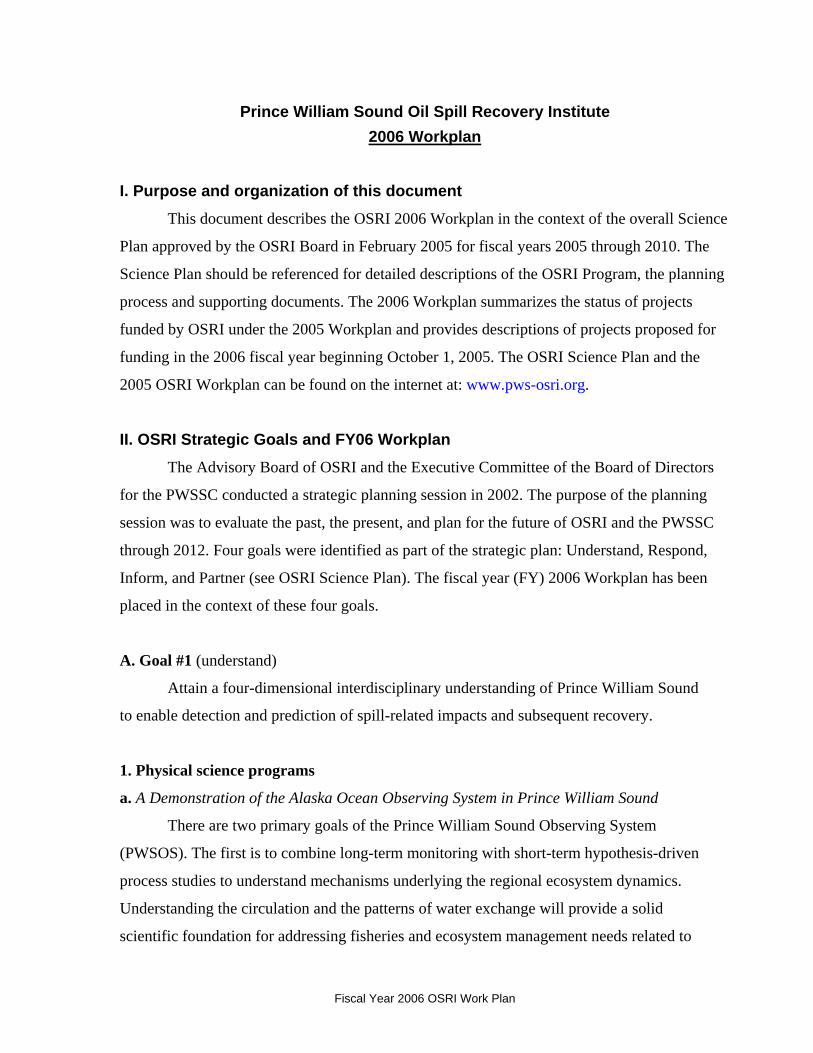
Figure 1. Satellite image that shows the Prince William Sound region and the locations of in situ observational instrumentation. Red symbols indicate real-time data accessible on the internet, yellow are data loggers (not real-time), and purple are real-time but not accessible.
Fiscal Year 2006 OSRI Work Plan
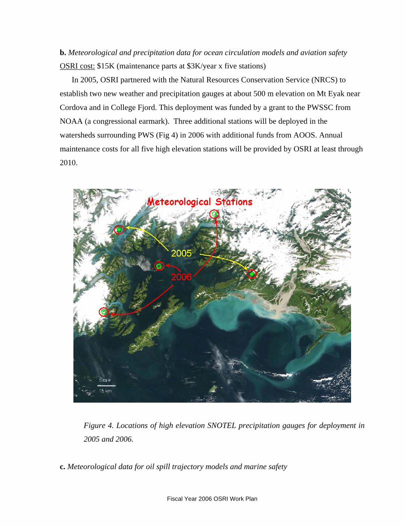
b. Meteorological and precipitation data for ocean circulation models and aviation safety
OSRI cost: $15K (maintenance parts at $3K/year x five stations)
In 2005, OSRI partnered with the Natural Resources Conservation Service (NRCS) to
establish two new weather and precipitation gauges at about 500 m elevation on Mt Eyak near
Cordova and in College Fjord. This deployment was funded by a grant to the PWSSC from
NOAA (a congressional earmark). Three additional stations will be deployed in the
watersheds surrounding PWS (Fig 4) in 2006 with additional funds from AOOS. Annual
maintenance costs for all five high elevation stations will be provided by OSRI at least through
2010.
Figure 4. Locations of high elevation SNOTEL precipitation gauges for deployment in
2005 and 2006.
c. Meteorological data for oil spill trajectory models and marine safety
Fiscal Year 2006 OSRI Work Plan
OSRI cost: $25K ($10K for logistics, plus $15K/year for maintenance parts at $3K/year x
five stations)
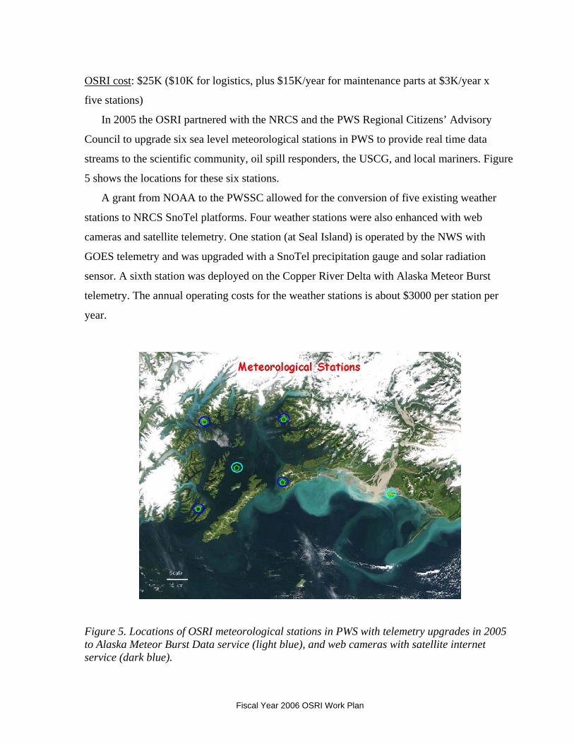
In 2005 the OSRI partnered with the NRCS and the PWS Regional Citizens’ Advisory
Council to upgrade six sea level meteorological stations in PWS to provide real time data
streams to the scientific community, oil spill responders, the USCG, and local mariners. Figure
5 shows the locations for these six stations.
A grant from NOAA to the PWSSC allowed for the conversion of five existing weather
stations to NRCS SnoTel platforms. Four weather stations were also enhanced with web
cameras and satellite telemetry. One station (at Seal Island) is operated by the NWS with
GOES telemetry and was upgraded with a SnoTel precipitation gauge and solar radiation
sensor. A sixth station was deployed on the Copper River Delta with Alaska Meteor Burst
telemetry. The annual operating costs for the weather stations is about $3000 per station per
year.
Figure 5. Locations of OSRI meteorological stations in PWS with telemetry upgrades in 2005 to Alaska Meteor Burst Data service (light blue), and web cameras with satellite internet service (dark blue).
Fiscal Year 2006 OSRI Work Plan
d. PWS circulation and water exchange processes in Hinchinbrook Entrance and
Montague Strait (by Claude Belanger, PWSSC)
OSRI cost: $75K ($10K equipment, $15K logistical support, plus $35K PWSSC
technician salary, plus $15K for project senior advisor)
This program is a constituent of the Prince William Sound Observing System
(PWSOS). In its current state, the program encompasses three components: 1) Long-term
monitoring of the water exchange between the Gulf of Alaska (GOA) and Prince William
Sound (PWS), 2) Long-term monitoring of sea water temperature, salinity and fluorescence at
nearshore sites in northern and western PWS, and 3) Monitoring of the seasonal variability of
the hydrographic properties and circulation in PWS.
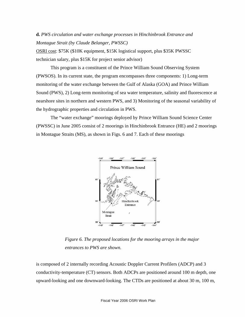
The “water exchange” moorings deployed by Prince William Sound Science Center
(PWSSC) in June 2005 consist of 2 moorings in Hinchinbrook Entrance (HE) and 2 moorings
in Montague Straits (MS), as shown in Figs. 6 and 7. Each of these moorings
Figure 6. The proposed locations for the mooring arrays in the major
entrances to PWS are shown.
is composed of 2 internally recording Acoustic Doppler Current Profilers (ADCP) and 3
conductivity-temperature (CT) sensors. Both ADCPs are positioned around 100 m depth, one
upward-looking and one downward-looking. The CTDs are positioned at about 30 m, 100 m,
Fiscal Year 2006 OSRI Work Plan
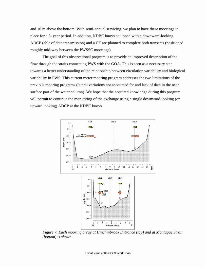
and 10 m above the bottom. With semi-annual servicing, we plan to have these moorings in
place for a 5- year period. In addition, NDBC buoys equipped with a downward-looking
ADCP (able of data transmission) and a CT are planned to complete both transects (positioned
roughly mid-way between the PWSSC moorings).
The goal of this observational program is to provide an improved description of the
flow through the straits connecting PWS with the GOA. This is seen as a necessary step
towards a better understanding of the relationship between circulation variability and biological
variability in PWS. This current meter mooring program addresses the two limitations of the
previous mooring programs (lateral variations not accounted for and lack of data in the near
surface part of the water column). We hope that the acquired knowledge during this program
will permit to continue the monitoring of the exchange using a single downward-looking (or
upward looking) ADCP at the NDBC buoys.
Figure 7. Each mooring array at Hinchinbrook Entrance (top) and at Montague Strait (bottom) is shown.
Fiscal Year 2006 OSRI Work Plan
A third component consists of a regular monitoring of the hydrographic properties in
the central basin of PWS and at the main entrances. A direct goal of this work is to acquire a
description of the seasonal evolution of the hydrographic properties at these locations. This is
done through seasonal vessel-based hydrographic surveys (4 cruises per year) during which
CTD profiles are acquired at a number of stations. For each survey, four transects (west-east,
north-south, HE and MS) are visited (giving a total of 28 stations), and extra stations may be
added depending on the needs of the moment. The planned duration of this project is the same
as for the “water exchange” moorings.
For the “water exchange” and “seasonal surveys” components of the program, the
data will be processed at PWSSC, archived at UAF, and posted on an internet site
maintained at the Alaska Experimental Forecast Facility (AEFF) in Anchorage. There will
be a monthly quality control at PWSSC and the quality controlled data will be sent to
replace the raw data. The data from the three components will be downloadable and the
diverse information relative to data acquisition and processing will be provided in
downloadable data reports.
Mooring maintenance through 2010 will be conducted about every six months with funding
from OSRI. The moorings were deployed in June 2005. During the first recovery mission
scheduled for September 2005, the HE subsurface moorings will be recovered and while
aboard ship, the data will be downloaded from the instruments, the instruments cleaned, and
the mooring strings inspected and then re-deployed for another six months. The MS subsurface
instruments will be replaced with spares. In May 2006, the HE moored instruments will be
replaced with spares, and the MS moored instruments will be cleaned and then re-deployed for
another six months. The sampling strategy of sequential six-month deployments is preferable
to a single, yearlong deployment because the risk of data loss due to instrument failure/loss is
diminished. This six-month rotation cycle will continue for a minimum of 5 years.
The simplest data analyses will be time series plots of the physical field variables (velocity,
transport, temperature, salinity, and winds) measured in or near HE and MS. Basic statistical
measures such as record mean, variance, and monthly mean will be computed for each time
series. Axes of maximum variance will be computed for currents at each bin depth for each
mooring location and for winds at each wind observation location. Correlations between the
time series of physical field variables will also be computed. Least squares methods will be
Fiscal Year 2006 OSRI Work Plan
used to extract the principal tidal constituents from the ADCP velocity data. A time series of
subtidal volume transports will be calculated from the de-tided records. All subsurface mooring
data will be posted on the web within one month of instrument recovery. The NDBC will
process and post ADCP and CTD data from the surface buoy in real time. OSRI will fund the
logistics costs and the salary of a marine technician (.5 FTE) to aid with the maintenance and
deployment of the oceanographic moorings, instrument calibration, and data processing. OSRI
will also fund a senior advisor to oversee the project.
e. PWSSC oceanography research fellowship (Post doctoral data analyst)
OSRI cost: $75K
The intent of the OSRI Post doctoral positions is to 1) provide research staff to the
PWSSC; 2) to research diverse issues relevant to the OSRI mission; and 3) to maintain the
highest caliber of research possible. The term of the post doc positions are two years, with
possible one-year extensions if the project warrants the extra time. The intent is not to support
full time PWSSC staff, but staff can advise post docs and leverage other funds to utilize the
expertise of OSRI post docs for their projects. Post docs will be recruited and hired by the
PWSSC based on competitive ranking of criteria including but not limited to their task relevant
expertise, education, experience, and recommendations from previous employers
For the oceanography program, OSRI will fund a postdoctoral position to conduct basic
and applied research in Prince William Sound and the Gulf of Alaska utilizing the ocean
observing system to meet one or more of the OSRI research focus issues. The general research
focus will be on understanding the physical circulation and mixing of PWS waters and how
these affect oil spill trajectories in space and time. The research area includes the Sound and
the adjacent Gulf of Alaska. This position will be responsible for two main categories of work:
1) participate in the research and monitoring programs required by the OSRI grant, including
hydrographic data acquisition and analyses, drifter trajectory analyses, large scale field
experiments, and publication in peer reviewed journals (75%), and 2) assume a lead role in
securing external funds to develop process oriented studies to further our understanding of how
PWS, the Gulf of Alaska, and the surrounding watersheds interact (25%). Under the first
category, this position will be responsible for the routine quarterly oceanographic transects
across Hinchinbrook Entrance and Montague Strait, as well as maintaining fixed moorings and
Fiscal Year 2006 OSRI Work Plan
meteorological arrays, and telemetry networks as part of the PWS Observing System. The
position will also be required to participate in an integrated science, education, and outreach
program conducted by the education staff of the PWSSC.
2. Biological science programs
a. Funding partnership with the North Pacific Research Board (NPRB)
Funding partners: NPRB OSRI cost:$100K
The NPRB and OSRI have science plans that encourage research partnerships. Section
4.2.3 of NPRB’s science plan directly responds to a strong recommendation of the National
Research Council to seek partnerships with other entities to support joint research and funding
of projects of mutual interest. Similarly, Section IV.A.5.b.i of OSRI’s science plan identifies a
potential partnership with NPRB to support ecological research projects in arctic and sub-arctic
climates, generally within the NPRB geographic area of interest, but with particular emphasis
on the Gulf of Alaska and Prince William Sound. Both organizations have a strong interest in
ocean observing, habitat, and ecological studies. The NPRB and OSRI have science and
implementation plans that provide the foundation for defining research priorities of mutual
interest in any given year. The OSRI science and implementation plans are cognizant of and
consistent with the NPRB Science Plan and the Gulf of Alaska Integrated Ecosystem Research
Plan.
A workshop sponsored by the Alaska Ocean Observing System to identify important
ecological issues in the Gulf of Alaska was held in Cordova during the summer of 2005.
Groups representing marine birds, marine mammals, nearshore habitats, and fishes, all
emphasized the need for more information on forage fish. An opportunity now exists to
conduct collaborative research on the role of forage fish in the Northern Gulf of Alaska and
Prince William Sound. Proposals to this joint RFP between OSRI and the NPRB would be
directed at more fully understanding the role of forage fish in the northern Gulf and Prince
William Sound ecosystems, physical and biological factors that cause fluctuations in forage
fish population size and/or range, and field operations that would aid in developing strategies
for filling information gaps, testing various techniques for assessment, and examining food
web relationships.
Some important questions include: how resilient is this ecosystem to changes in
Fiscal Year 2006 OSRI Work Plan
physical forcing and to alterations in upper trophic level community composition; e.g., what
are the relative roles of bottom-up and top-down forcing in shaping this ecosystem; what are
the major atmospheric and oceanic mechanisms including exchanges between Prince William
Sound and the adjacent shelf and slope that affect northern GOA ecosystem structure and
function? How do fluctuations of strength and eddy behavior of the Alaska Coastal Current,
together with its role as a source of nutrients, impact ecosystem dynamics, including
recruitment of commercially fished species, distribution and abundance of forage fish species,
and therefore populations of upper trophic fish, seabird and marine mammal species? How
does habitat quality and interspecific competition influence commercial and forage species
production and distribution. Are the criteria for "good habitat" similar for all forage species?
Is there the potential for competition among forage fish species? Are there interannual
variations in habitat quality and fish production? What are the potential effects of variations in
fish production to other trophic levels, e.g., seabirds and marine mammals?
The NPRB and OSRI Science Plans have each committed $100K/yr for 5 yrs to the
partnership initiative. Therefore, projects can be up to five years with combined OSRI-
NPRB support of $200,000/year.
b. PWSSC Biological Monitoring Grant
OSRI cost: $75K
Neocalanus copepods and pteropods represent the bulk of forage for planktivorous
fishes (herring, walleye Pollock, salmon fry, etc.) during the annual spring bloom in Prince
William Sound. Past zooplankton studies supported by OSRI have verified and elucidated the
importance of large zooplankton for pink salmon survival. Given the importance of
zooplankton as forage for fishes at risk to oil spills, OSRI will continue funding the monitoring
of zooplankton and fish populations in FY06. For more information on this program, see:
http://www.pwssc.gen.ak.us/hydroacoustics/hydroacoustics.html
c. PWSSC Copper River Delta Grant
OSRI cost: $75K
Beginning in the spring of 2000, OSRI funded studies on the intertidal resources of the
Copper River Delta at risk to oil spills. In 2003, the research program was expanded with new
Fiscal Year 2006 OSRI Work Plan
funding support from the Exxon Valdez Oil Spill Trustee Council’s Gulf Ecosystem
Monitoring program. The ultimate goal of the Copper River Delta research is to understand the
spatial and temporal dynamics of the biological community of the Copper River Delta in order
to predict how this community would respond to anthropogenic (e.g., an oil spill) or naturally
induced changes (e.g., climate change) in the physical and chemical environment. The
approach to achieve this goal has been to focus on the central part of the food web (benthic
invertebrates) and then to add components that focus on higher (predators) and lower trophic
levels (primary producers) as funding allows. The FY05 OSRI funding represents year 2 of a
3-year project that will be completed at the end of FY06. For further information on this
project, see: http://www.pwssc.gen.ak.us/nearshore/MarineInvert-Bishop.html
3. Modeling
a. Atmospheric circulation modeling (by Peter Olsson, AEFF)
OSRI cost: $60K (technicians salary and computer costs for operational mode forecasts)
At the Alaska Experimental Forecast Facility (AEFF), a daily numerical weather
forecast model— the Regional Atmospheric Modeling System (RAMS)— is operational for
the region of Prince William Sound (PWS). As is true of all weather forecast models, this
involves using computers (lots of computers) to solve a mathematical model of how we think
the atmosphere works. In fact this is the same thing that the National Centers for
Environmental Prediction (NCEP) does for the National Weather Service (NWS). What is
different with our project is that while NCEP does this for all of Alaska, AEFF concentrates
available computing power on the region of Prince William Sound. This allows for a finer-
scale grid spacing (4-km) than the NCEP models (12.5 km at best). This finer resolution
accommodates smaller scale topographic effects that are not in the NWS simulations
In our study we exploit the capability in RAMS of grid nesting, in effect telescoping
down from a coarse grid-mesh grid that covers all of Alaska and surrounding oceans, to an
intermediate grid that covers all of southern Alaska and the Gulf of Alaska, and ultimately
down to the fine-mesh grid that covers PWS and its surrounding terrain/ocean.
The model simulations produce hourly 3-d forecast fields of a host of variables,
including: temperature. pressure, winds (3-d), humidity, precipitation, and cloudiness. This is
just a small sampling of variables of most interest to most users, a host of other 2- and 3-d
Fiscal Year 2006 OSRI Work Plan
variables are available and more can be calculated from the raw output.
The model can also act as an integrator of data, by filling in the gaps or data voids.
Several weather stations have been deployed in the Sound and there are several C-MAN
stations and NDBC buoys in the Sound. Still there are several data-sparse sections in a
region where weather and wave conditions can vary dramatically over a scale of 10 km or
so. The model can act to fill in the gaps, acting as surrogate observations in those places
where direct observations do not exist. These are, of course, predictions and so will never
replace having an actual observation at a given point in space and time
The RAMS output is currently available at the AEFF Weather Briefer’s web page:
http://aeff.uaa.alaska.edu/wx_brief.html
To access the PWS images, click on the RAMS button on the left of the page, choose the
12Z forecast time on the top right hand choose Prince William Sound as the domain. The
select the field of interest and a time-step (3 hr is recommended for slow connections)
b. Synoptic wave modeling (by Vijay Panchang, TAMU)
OSRI cost: $5K (post doc salary and computer costs for operational mode forecasts)
The basic system has been developed to extend NOAA’s coarse-grid ocean wave
forecasts into the Prince William Sound area. We have developed the computer protocols to
interface this local PWS domain to the outer-ocean NOAA predictions. We have established
the procedures to do this automatically. At intervals of 12 hours, wave spectral information
from NOAA’s predictions at grid-points on the local model boundary and NOAA’s wind-fields
are downloaded. With these inputs, the local model SWAN is now running continuously, and
the results are posted on TAMUG website every 12 hours. The results are automatically
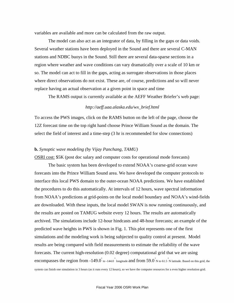
archived. The simulations include 12-hour hindcasts and 48-hour forecasts; an example of the
predicted wave heights in PWS is shown in Fig. 1. This plot represents one of the first
simulations and the modeling work is being subjected to quality control at present. Model
results are being compared with field measurements to estimate the reliability of the wave
forecasts. The current high-resolution (0.02 degree) computational grid that we are using
encompasses the region from -149.0o
to -144.0 o
longitude and from 59.0 o
N to 61.5 o
N latitude. Based on this grid, the
system can finish one simulation in 3 hours (as it runs every 12 hours), so we have the computer resources for a even higher resolution grid.
Fiscal Year 2006 OSRI Work Plan
Because we are still in the early stages of this project, the resolution of the current grid most likely will be changed to a higher resolution based
on comparison of the model results and field measurements. Currently we are working on switching to the project’s “official” bathymetry set
Fig. 1. Significant Wave height forecast for Prince William Sound in Alaska. and the “official”
wind-fields (rather than the NOAA winds we are now using). We are also exploring the use of
artificial neural networks to provide point forecasts from instruments; wave height forecasts
using data are being made for buoys 46082 and 46060 (e.g. Fig. 2). This technique may help
to “add value” to the expanding network of instruments and also to effect judicious and
efficient deployment of instruments in the future.
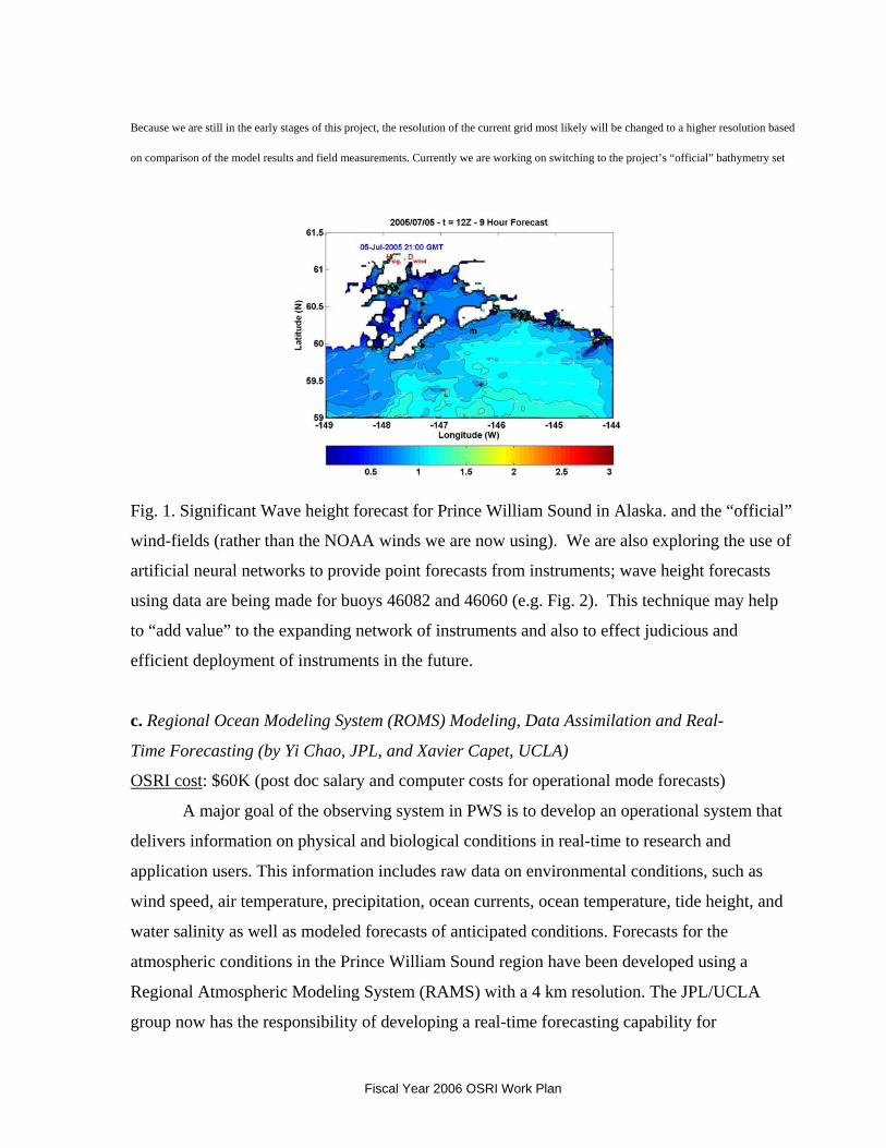
c. Regional Ocean Modeling System (ROMS) Modeling, Data Assimilation and Real-
Time Forecasting (by Yi Chao, JPL, and Xavier Capet, UCLA)
OSRI cost: $60K (post doc salary and computer costs for operational mode forecasts)
A major goal of the observing system in PWS is to develop an operational system that
delivers information on physical and biological conditions in real-time to research and
application users. This information includes raw data on environmental conditions, such as
wind speed, air temperature, precipitation, ocean currents, ocean temperature, tide height, and
water salinity as well as modeled forecasts of anticipated conditions. Forecasts for the
atmospheric conditions in the Prince William Sound region have been developed using a
Regional Atmospheric Modeling System (RAMS) with a 4 km resolution. The JPL/UCLA
group now has the responsibility of developing a real-time forecasting capability for
Fiscal Year 2006 OSRI Work Plan
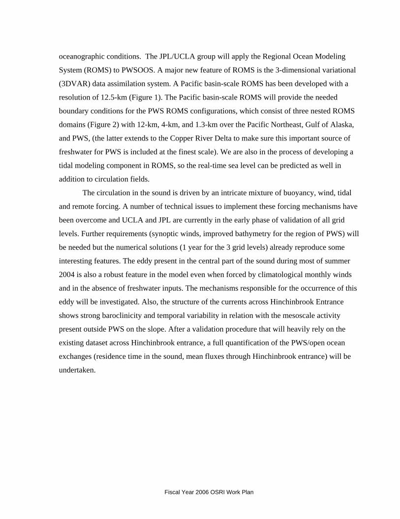
oceanographic conditions. The JPL/UCLA group will apply the Regional Ocean Modeling
System (ROMS) to PWSOOS. A major new feature of ROMS is the 3-dimensional variational
(3DVAR) data assimilation system. A Pacific basin-scale ROMS has been developed with a
resolution of 12.5-km (Figure 1). The Pacific basin-scale ROMS will provide the needed
boundary conditions for the PWS ROMS configurations, which consist of three nested ROMS
domains (Figure 2) with 12-km, 4-km, and 1.3-km over the Pacific Northeast, Gulf of Alaska,
and PWS, (the latter extends to the Copper River Delta to make sure this important source of
freshwater for PWS is included at the finest scale). We are also in the process of developing a
tidal modeling component in ROMS, so the real-time sea level can be predicted as well in
addition to circulation fields.
The circulation in the sound is driven by an intricate mixture of buoyancy, wind, tidal
and remote forcing. A number of technical issues to implement these forcing mechanisms have
been overcome and UCLA and JPL are currently in the early phase of validation of all grid
levels. Further requirements (synoptic winds, improved bathymetry for the region of PWS) will
be needed but the numerical solutions (1 year for the 3 grid levels) already reproduce some
interesting features. The eddy present in the central part of the sound during most of summer
2004 is also a robust feature in the model even when forced by climatological monthly winds
and in the absence of freshwater inputs. The mechanisms responsible for the occurrence of this
eddy will be investigated. Also, the structure of the currents across Hinchinbrook Entrance
shows strong baroclinicity and temporal variability in relation with the mesoscale activity
present outside PWS on the slope. After a validation procedure that will heavily rely on the
existing dataset across Hinchinbrook entrance, a full quantification of the PWS/open ocean
exchanges (residence time in the sound, mean fluxes through Hinchinbrook entrance) will be
undertaken.
Fiscal Year 2006 OSRI Work Plan
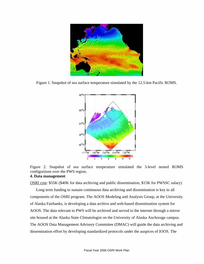
Figure 1. Snapshot of sea surface temperature simulated by the 12.5-km Pacific ROMS.
Figure 2. Snapshot of sea surface temperature simulated the 3-level nested ROMS configurtions over the PWS region. 4. Data management
OSRI cost: $55K ($40K for data archiving and public dissemination, $15K for PWSSC salary)
Long term funding to sustain continuous data archiving and dissemination is key to all
components of the OSRI program. The AOOS Modeling and Analysis Group, at the University
of Alaska Fairbanks, is developing a data archive and web-based dissemination system for
AOOS. The data relevant to PWS will be archived and served to the internet through a mirror
site housed at the Alaska State Climatologist on the University of Alaska Anchorage campus.
The AOOS Data Management Advisory Committee (DMAC) will guide the data archiving and
dissemination effort by developing standardized protocols under the auspices of IOOS. The
Fiscal Year 2006 OSRI Work Plan
prototype web page for data dissemination is at http://www.aoos.org. This component of the
Science Plan ensures sustained support for data dissemination and archiving through the UAA
mirror site. The technician salary is to cover the costs of operating and maintaining the data
communication links between the Cordova based PWSSC, and UAF and UAA.
5. Research fellowships (2)
The OSRI is focusing on research within high latitude areas at risk from oil and gas
activities. Under Goal#1 of the OSRI strategic plan, the suggested focus areas for research
projects funded by the OSRI fellowship program are:
Ocean observations and modeling
. • seasonal and interannual variation of ocean circulation and mixing;
. • quantitative ecology of marine and estuarine habitats.
a. Graduate student fellowships
OSRI cost: $50K (two students at $25K per student per year)
OSRI funds are provided to support graduate student research projects that will enhance
scientific understanding of the marine ecosystem, provide information needed by managers and
decision-makers for oil spill response and recovery, and improve public awareness and
understanding of marine and estuarine ecosystems. The OSRI Graduate Research Fellowship
(GRF) Program offers qualified master's and doctoral students the opportunity to address
scientific questions of significance to high latitude cold climate regions (see OSRI Science
Plan). The result is high-quality research focused on improving oil spill response and recovery
issues.
Abstract by Sean-Bob Kelly (funded for 2005 and 2006, University of Alaska Fairbanks)
The overall objective of this study is to identify past habitat use and essential habitat of
Pacific herring (Clupea pallasii) from Prince William Sound (PWS). My specific objectives
are to (1) use trace element signatures of core portions of herring otoliths to identify individual
spawning bays within PWS, (2) use trace element signatures of edge portions of juvenile
herring otoliths to identify individual rearing bays within PWS, (3) use adult otoliths to identify
Fiscal Year 2006 OSRI Work Plan
bays that contribute a greater portion to the herring population, and (4) use adult otoliths to
identify past habitat use and temporal changes.
My research focus fits within OSRI research focus area (#1), the observation and
modeling of the quantitative ecology of marine and estuarine habitats. Following the Exxon
Valdez oil spill in March 1989 and the decline of herring stocks in the 1990´s, the need for
quantitative analysis of essential fish habitat has become more critical to the conservation of
this important fisheries stock. Identification of essential fish habitats (EFH) for various life
stages of herring in PWS is necessary to examine the status and recovery potential of the stock,
which is a priority of fisheries managers. Identification of habitat change since 1995, the oldest
available samples, through 2006, the latest samples, would be an indicator of the recovery of
the herring populations in PWS. Herring spawning on documented oil-damaged habitat and
surviving to recruitment is an indication that those habitats have recovered. Otolith chemical
analysis of regional signatures enables my research to quantify ecological recovery status
through shifts in herring habitat usage over time.
Abstract by Xinglong Wu (funded for 2004-2006, University of Miami) The goal of the present
study is to understand the response of Prince William Sound (PWS) to such forcing as surface
wind, atmospheric pressure, tides, buoyancy flux, inflow and mass structures at open
boundaries, and bottom topography. and to evaluate the relative roles played by these forcings
in driving the synoptic and general circulation in the Sound. Specifically, the following
questions are expected to be answered in the dissertation: 1. 1. Why does a large cyclonic gyre occur in PWS in September with little year-to-year variability, while in other seasons the circulation pattern in central PWS could be transient in either the cyclonic or anti-cyclonic direction? 2. 2. How does the seasonal inflow/outflow structure in Hinchinbrook Entrance (HE) change the circulation in PWS? Considering the sills just outside the two main entrances guarding the Sound from the NGOA coastal waters, and what controls the properties and variability of the PWS deep water? 3. 3. What is the nature and strength of the buoyancy-driven (thermohaline) circulation in a small semi-enclosed sea such as PWS? 4. 4. Associated with the complex bottom topography and density stratification in PWS, what roles do the tides, including barotropic and baroclinic components, play in influencing the general circulation? How much of the tidal energy is dissipated inside the Sound? What is the Sound’s annual tidal energy budget?
Fiscal Year 2006 OSRI Work Plan
B. Goal #2 (respond): Enhance the ability of oil spill responders to mitigate impacts of spills
in Arctic and sub-Arctic marine environments.
1. Technology research and development
Funding partners: Cooperative Institute for Coastal and Estuarine Environmental Technology
(CICEET), Coastala Response Research Center (CRRC), Minerals Management Service
(MMS) OSRI cost: $150K
In 2004, CRRC, CICEET and OSRI formed a partnership for the development and
application of new technologies, and/or innovative approaches using existing technologies, to
address issues related to oil spill response and restoration in cold climate coastal marine areas
and the Great Lakes. In 2005, MMS joined the partnership. This collaboration will allow the
partners to take advantage of pooled funding and resources, while supporting their individual
missions. CRRC is a partnership between the University of New Hampshire (UNH) and the
National Oceanic and Atmospheric Administration (NOAA); the goal of the Center is to reduce
the consequences of spills and other hazards threatening coastal environments and
communities. Additional information about this Center can be found at www.crrc.unh.edu.
CICEET is also a partnership between NOAA and UNH and was established as a national
center for the development and application of innovative environmental technologies for
monitoring, management and prevention of contamination in estuaries and coastal waters.
Additional information can be found on the CICEET website (http://ciceet.unh.edu). OSRI was
established to conduct research and educational and demonstration projects in order to identify
and develop the best available techniques, equipment and materials for dealing with oil spills in
Arctic and sub-arctic marine environments. Additional information about OSRI can be found at
www.pws-osri.org. MMS is the Federal agency responsible for managing the nation’s natural
gas, oil and other mineral resources in Federal waters offshore the U.S. Information on MMS
can be found at www.mms.gov. A partnership between these Centers for the purpose of this
RFP will use the strengths and expertise of each and allow for the solicitation and funding of a
broad, integrated range of relevant research. The projects will be funded and administered by
the individual partners; the results of the funded projects will be disseminated by all of the
partners.
The goals of this partnership for cold climate spill research are to:
Fiscal Year 2006 OSRI Work Plan
1. 1. Conduct research and development on new technologies for preventing, responding to, and recovering from oil spills. 2. 2. Identify and develop cost effective technology and methods for the restoration of spill impacted habitats and ecosystems. 3. 3. Facilitate and promote collaborative research and development and the exchange of ideas to increase collective productivity and the application of the findings to improve technological and operational activities in spill preparedness, response and restoration. 4. 4. Involve students (undergraduate and graduate) to the extent practical in ongoing research, testing, and demonstration activities.
CRRC, CICEET, MMS and OSRI are collaborating in this effort to conduct research
and development on new technologies for responding to oil spills in cold climate coastal
marine areas and the Great Lakes. For the purpose of this RFP, cold climate environments are
defined as having average annual winter (January, February and March) water temperatures
less than or equal to 38° F. Geographical areas of special interest include those subject to
severe storms, large waves, and prolonged winter weather, as these regions may develop
extensive broken or continuous ice. Research areas of special interest include developing
techniques and technologies to: detect oil in ice, remove oil from under ice or from broken ice,
prevent the spread of spilled oil in ice covered waters or in broken ice, improve the
effectiveness and efficiency of response operations, and to restore and recover impacted
habitats and ecosystems in cold climate environments. Specific research areas of interest for
this cold climate RFP include, but are not limited to: 1. 1. Exposure and Injury Assessment Tools: Development of new, cost effective tools that can be rapidly deployed, including technologies, methods, protocols and models and their application for assessing the exposure and injury of marine resources to the presence of oil in the water column, on or under ice, in and among broken ice, in sediments or in organisms. A proposed tool should be simple, rapidly deployable, low cost, and easy to use. A developed tool being applied to a cold climate must be suitable for commercialization. 2. Data Development: Processes and Rates Affecting Oil: Data and information on the short and long term processes and rates affecting the composition and properties of oil as a function of three dimensional transport, and/or stranding in cold climates. The proposed work may consider the interaction of oil and relevant habitat type (i.e., changes in oil composition, toxicity and effects as a result of habitat type) as a part of this effort. Habitat types must be those of cold climates, as defined above. The results of this work must be quantitative and suitable for modeling. 2. 3. Human Use Valuation of Ecosystems: Valuation or valuation methods for human use of ecosystem components and attributes (e.g., subsistence fishing and hunting, recreational boating and tourism) impacted by cold climate oil spills. The methods or developed data must be suitable for quantifying lost or diminished use and provide information to monitor the progress of restoration.
Fiscal Year 2006 OSRI Work Plan
3. 4. Habitat Recovery and Restoration Technologies: Efficient, effective technologies to expedite the recovery and restoration of spill impacted habitats and organisms. The project results must quantitatively demonstrate the effectiveness of the technology. 4. 5. Oil Recovery and Spread Prevention: Development of new technologies or operational methods to prevent the spread and/or improve the recovery of spilled oil associated with ice or broken ice.
The partnership will issue joint annual solicitations through the CRRC. The partnership
will issue one solicitation and will involve joint marketing, joint review, but then separate
funding (OSRI funds one or two projects, CICEET funds one or two, CRRC funds one or
two). All parties would get credit for supporting the partnership. At this time, the level of
funding agreed upon is $200K from CICEET, $100K from CRRC, $150K from OSRI, and
$100K from MMS. CRRC will develop an online database and project archive for public
dissemination of projects and project results. The 2006 RFP is on the internet at:
www.crrc.unh.edu.
2. Research fellowships (1)
The OSRI is focusing on research within high latitude areas at risk from oil and gas
activities. Under Goal#2 of the OSRI strategic plan, the suggested focus areas for
research projects funded by the OSRI fellowship program are:
Technology development
. • mechanisms for removing oil from water, sediments, and oil in and under ice;
. • quantifying the fate and effects of oil spills in high latitude cold climates; a. Graduate student fellowships
OSRI cost: $25K (one student at $25K per student per year)
OSRI funds are provided to support graduate student research projects that will design
and/or develop technologies and techniques to aid in the response and recovery of oil spills in
high latitude cold climates, provide information needed by managers and decision-makers for
oil spill response and recovery, and improve public awareness and understanding of marine
and estuarine ecosystems. The OSRI Graduate Research Fellowship (GRF) Program offers
qualified master's and doctoral students the opportunity to address scientific questions of
significance to high latitude cold climate regions. The result is high-quality research focused
Fiscal Year 2006 OSRI Work Plan
on improving oil spill response and recovery issues.
Abstract by Jim Alanko (funded for 2005-2007, University of Alaska Fairbanks)
The temporal variability in Prince William Sound surface current patterns occurs over
interannual, seasonal, synoptic, and tidal time scales and the spatial variability associated
with these circulation patterns is significant. Yet the variability has been under sampled in
both time and space. I propose to use newly available High Frequency radar technology to
measure and analyze the surface currents of Prince William Sound and provide the first
comprehensive study of the variability of surface circulation patterns. This technology will
be used to provide hourly maps with spatial resolutions of approximately 2 km. I will also
investigate the relationship of the surface current patterns to wind forcing, flow through
Hinchinbrook Entrance and Montague Strait, and tides. As part of this project, I will
investigate the use of surface current maps from High Frequency radar for trajectory
analysis for oil spill contingency planning and for use in search and rescue scenarios. This
work will address the research focus area specified in the GRF Program Description
“Observations and Modeling”: seasonal and interannual variation of oceanic or
atmospheric circulation, stratification, and mixing.
C. Goal #3 (inform): Disseminate information and educate the public on the issues of oil
spill prevention, response, and impacts.
1. Education
OSRI intends to continue building upon the existing regional outreach programs. In
addition, within the next year, OSRI will seek out partnering opportunities to broaden the
geographic influence of the PWSSC education programs to state and national audiences and
share expertise among a consortium of other education and outreach institutions.
a. Discovery Room
OSRI cost: $40K (PWSSC education staff salaries and program materials)
The Discovery Room and Outreach Discovery programs create the opportunity for hands-
Fiscal Year 2006 OSRI Work Plan
on science in both classroom and outdoor settings. The Discovery Room enhances the science
curriculum for 300 Cordova students in kindergarten through sixth grade. This program alone
provides 16,200 contact hours to Cordova children each year. Outreach Discovery takes
Discovery Room lessons to the villages of Chenega Bay and Tatitlek. These lessons greatly
enhance the limited resources these schools have available for science education. Community
Programs serve adults and families in Cordova and include field trips, lectures, and seminars.
b. Forest to the Sea
OSRI cost: $15K (PWSSC education staff salaries and program materials)
This summer camp program provides the tools and guidance for campers to understand the
interdependence of all ecosystems. Hands-on education in the outdoor classroom and scientific
knowledge, combined with positive experiences in the outdoors, builds a foundation for
campers to grow into good environmental stewards and wise decision-makers. While immersed
in their surroundings, participants learn how ecosystems are connected through interactive
studies of the temperate rainforest, glacier, wetlands, and ocean.
c. Coastal community outreach and education
OSRI cost: $15K
For 12 years the Prince William Sound Science Center has augmented local education
curriculum with hands-on science programs and, in addition to Cordova students, has delivered
these programs to Tatitlek and Chenega Bay. In order to expand delivery of these classes to
other remote coastal Alaska communities we are partnering with organizations such as the
Imaginarium, the Denali Institute, and the Yosemite Institute to develop programs with a
general emphasis on the marine environment. We will explore ways of utilizing the real time
data streams and model output from the PWSOS in the classroom.
d. High school student scholarships
OSRI cost: $1K
OSRI will provide institutional sponsorship for the annual Cordova Science Festival by
providing scholarships for winners of presentation categories, including posters,
demonstrations, and oral presentations.
Fiscal Year 2006 OSRI Work Plan
e. National Ocean Sciences Bowl
OSRI cost: $4K (staff salary and institutional sponsorship)
OSRI will provide institutional sponsorship for the Alaska Tsunami Bowl, the
regional competition for the National Ocean Science Bowl. This program encourages
high school students to excel in math and science studies by involving them in a quiz-
bowl competition focused on ocean sciences.
2. Research fellowships (1)
a. Student fellowships
OSRI cost: $25K (one student at $25K per student per year)
Under Goal#3 of the OSRI strategic plan, the suggested focus areas for research
projects funded by the OSRI fellowship program are: 1. 1. Social science, education, and outreach; 2. 2. economic, sociological, and/or anthropological research applicable to the effects of oil spills on coastal communities; 3. 3. application of ocean observing system products in coastal community education programs.
OSRI funds are provided to support graduate and native student projects that will
better understand the social and economic effects of oil spills on coastal communities,
provide information needed by managers and decision-makers for oil spill response
and recovery, and improve public awareness and understanding of marine and
estuarine ecosystems.
Abstract by Catherine Foster (funded for 2005, University of Washington)
This project will employ archaeological and paleoenvironmental data to assess the
effects of climate change on resource availability over the last 2200 years along the
northeastern Pacific Rim, and will test the effects of this availability on prehistoric
fisheries. It is well known that prehistoric fisheries along the northeastern Pacific Rim
depended heavily on salmon, and also that the resources in this region fluctuated both
temporally and spatially. Recent data produced by Dr. Bruce Finney (Finney et al. 2002)
show that salmon abundance fluctuated dramatically over the last 2200 years due to
Fiscal Year 2006 OSRI Work Plan
climate change, and the research proposed here will assess the effects of these
fluctuations on human foraging strategies.
The proposed project will examine these issues in the context of foraging theory to
test whether people altered their foraging strategies to accommodate climate change and
resource fluctuation by moving their fisheries from the riverine to the marine
environment. To test this hypothesis, several lines of evidence will be utilized: a) stable
oxygen isotopes extracted from fish otoliths will be used to reconstruct the
paleoenvironment; b) archaeological faunal materials will be analyzed to test for changes
in foraging focus; and c) salmon abundance data from the last 2200 years will be used as
a control for the paleoenvironmental and archaeological data.
The significance of this project lies in its unique archaeological perspective, and the
potential of archaeological data to contribute to an understanding of the larger, long-term
processes affecting the marine environment, fish ecology, human-environmental
interaction and climate change, and Native Alaskan fisheries.
3. Outreach
a. OSRI Advisory Board discretionary
workshops OSRI cost: $30K
These funds are for workshops or special projects at the discretion of the OSRI
Advisory Board.
b. OSRI web page maintenance and upgrades OSRI cost: $5K Support for upgrading the
OSRI web site and ongoing maintenance.
III. Administration A. Annual report
OSRI cost: $10K The OSRI will contract for a FY05 Report that details the
programmatic activities and provides a summary financial status report. This report
serves as a document of recording and evaluating the process of the OSRI program.
Fiscal Year 2006 OSRI Work Plan
C. Program coordination
OSRI cost: $120K The position of OSRI Research Program Manager is a programmatic
expense. The total costs include salary, benefits, travel and equipment..
B. OSRI Science and Technical Committee meetings
OSRI Cost: $15K
Funds are set aside to support the functions of the OSRI Science and Technical
Committee, and to support travel related expenses associated with OSRI partnerships
such as the CRRC, NPRB, etc.
Fiscal Year 2006 OSRI Work Plan