
15-03 Relief Line Public Meeting Presentation
35
March 2015 Public Meetings
-
Upload
toronto-public-consultation-unit -
Category
Government & Nonprofit
-
view
1.789 -
download
0
Transcript of 15-03 Relief Line Public Meeting Presentation

March 2015 Public Meetings

Why Are We Here Today?
Relief Line Project Assessment
1. Transit Planning in Toronto
2. Setting the Context
3. How Do We Address the Challenges?
4. Potential Station Areas
5. Evaluation Process and Framework
6. Public Consultation
2

DRAFT

Network Transit Planning
4
The Relief Line is being planned in the context of the overall Transit Network
25 Rapid Transit Projects are being reviewed as part of the “Feeling Congested?” Official Plan Review Process

How is Network Transit Planning Coordinated?
• Relief Line, SmartTrack and the Scarborough Subway Extension studies are interrelated – work is being coordinated for all three projects by City Planning
• Transit studies are all being led by City Planning, as part of overall transit network planning, in partnership with TTC
• Work on the Relief Line will inform the other projects and vice versa
• We are currently in the process of undertaking the integrated assessment
• We are seeking your input tonight on the Relief Line study
5
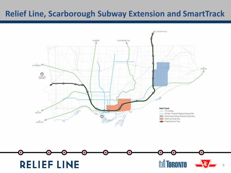
Relief Line, Scarborough Subway Extension and SmartTrack
6

Coordination of SmartTrack/RER and Relief Line
• Metrolinx and the Province are developing Regional Express Rail (RER) to provide 15 minute all-day transit service on all 7 GO corridors.
• SmartTrack is a part of RER, comprising elements on 3 of the 7 corridors.
• SmartTrack is expected to provide some relief to the Yonge Subway and may delay the need for the Relief Line. This needs to be assessed.
• The Metrolinx Yonge Relief Network Study will inform the timing of the Relief Line.
7

Key Dates for Related Transit Studies
8
• Consultation will be coordinated to ensure emerging findings of all initiatives are discussed in public meetings for these projects
• All of these rapid transit projects (Relief Line, Scarborough Subway Extension and SmartTrack/RER) have a target delivery of key findings for late 2015 –early 2016

9
Network Transit PlanningThe Relief Line is being planned in the context of the overall transit network

Local Transportation Planning Context Other initiatives and improvements that we will consider
10

DRAFT

Building Toronto
12
The Official Plan envisions a safe city that evokes pride, passion and a sense of belonging – a city where people of all ages and abilities can enjoy a good quality of life.
A city with…
A comprehensive and high quality affordable transit
system that lets people move quickly and conveniently

13
How did we get here?
2008 Metrolinx Big Move Includes Relief Line in 25-year regional transit network plan
2009 City Council Approves Yonge North Extension EA, contingent on Relief Line
City/TTC commence study to determine need for the Relief Line
2012 Downtown Rapid Transit Expansion Study Study concludes that initial phase of Relief Line and GO Transit improvements would help solve congestion on the transit network
2012 Relief Line identified as part of the “Next Wave” of transit projects
Relief Line identified by Metrolinx as a priority for future transit investment
2013 Ongoing Official Plan review identifies Relief Line as a top performing rapid transit project
Relief Line identified by City as a priority rapid transit project
2014 Yonge Relief Network Study launched Metrolinx commences work on a regional approach to addressing congestion on the Yonge Subway
2014 Relief Line Project Assessment launched City/TTC commence planning for the preferred route alignment and station locations for the Relief Line

Where Are We in the Study Process?
14

DRAFT

• Transfer between Bloor-Danforth and Yonge Subway Lines is seriously constrained
• Yonge Subway is currently over-capacity south of Bloor Station
• Capacity improvements now underway on Line 1 (YUS) include:‒ New “Toronto Rocket” Subway
Trains (+10% capacity)‒ Automatic Train Control (+25%
capacity)
• Crowding on the King and Queen Streetcar is deteriorating the quality of transit service
Existing Crowding and Congestion
16
0
4,000
8,000
12,000
16,000
20,000
24,000
28,000
32,000
36,000
40,000
Travel Today2031 Ridership Estimate2031 Ridership Estimate with Yonge line extension to Richmond Hill
Pas
sen
ger
Per
Ho
ur
in t
he
Pea
k D
irec
tio
n
Capacity Today (26,000)
2031
Forecasted
Riders
2031
Forecasted
Riders, with
Yonge Line
Extension
Riders
Today
Existing levels of crowding and congestion will continue to deteriorate without transit expansion

Future Conditions will Further Deteriorate Service
• Even with planned and funded improvements to Line 1 (YUS) by 2031 additional investment will be needed to accommodate growth
• Future extension of the Yonge Subway north will increase ridership
• Continued growth in the Downtown will attract ridership‒ 51% of GDP
‒ 33% of jobs (446,000)
‒ 557,000 m2 of office space being planned and under construction
‒ 18% Population Growth Between 2006-2011 (four times higher than the City as a whole)
17
0
4,000
8,000
12,000
16,000
20,000
24,000
28,000
32,000
36,000
40,000
Travel Today2031 Ridership Estimate2031 Ridership Estimate with Yonge line extension to Richmond Hill
Pas
sen
ger
Per
Ho
ur
in t
he
Pea
k D
irec
tio
n
Future Capacity (33-38,000*)
Capacity Today (26,000)
2031
Forecasted
Riders
2031
Forecasted
Riders, with
Yonge Line
Extension
Riders
Today
Additional transit capacity is needed to meet anticipated demand on the Yonge Subway Line
* DRTES used a capacity of 38,000 , the maximum potential for signalling improvementsActual capacity is expected to fall between 33,000 to 38,000 .


Relief Line Can Address Crowding and Congestion on the Transit Network
Lin
e 1
-Y
US
Sherbourne
Wellesley
Rosedale
Bay
The Relief Line will ease congestion at Yonge-Bloor by providing an alternative route to downtown
Source: DRTES Phase 1 Strategic Plan2031 Modeling includes Yonge Subway Extension
Line 2 - BD
Yonge -Bloor
Transfers at Yonge-Bloor will be reduced by 30% and Line 1 (Yonge) riders will be reduced by 12%
19

Initial Phase of Relief Line Addresses Downtown Streetcar Crowding
20
Source: DRTES Phase 1 Strategic Plan*Assumes the Yonge Subway Extension and modelled on a conceptual King Street corridor
Queen
King
The Relief Line reduces crowding on the downtown streetcar system, on both the Queen and King Lines
St. Andrew
Osgoode
Union
King Streetcar
Queen StreetcarUp to 35% of streetcar riders coming into Downtown from the east will be redirected to the Relief Line.
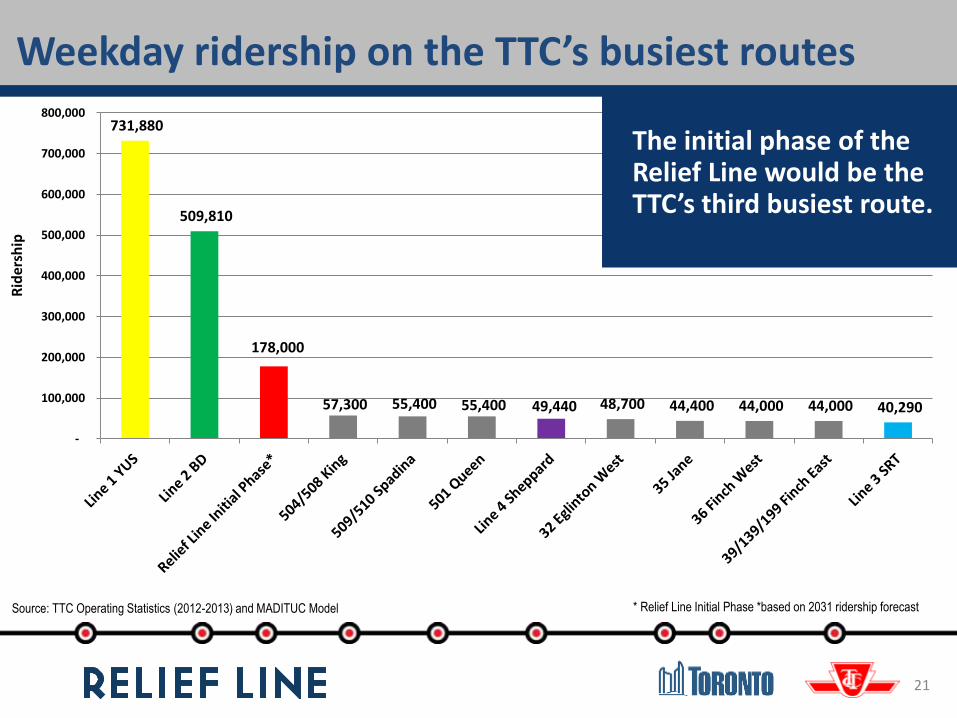
Weekday ridership on the TTC’s busiest routes
21
Source: TTC Operating Statistics (2012-2013) and MADITUC Model
731,880
509,810
178,000
57,300 55,400 55,400 49,440 48,700 44,400 44,000 44,000 40,290
-
100,000
200,000
300,000
400,000
500,000
600,000
700,000
800,000
* Relief Line Initial Phase *based on 2031 ridership forecast
The initial phase of the Relief Line would be the TTC’s third busiest route.
Rid
ersh
ip

22
Preferred Technology: Subway
• Subway is the right technology for the Relief Line:
‒ Serves transit network needs in terms of capacity, frequency, station spacing
‒ Addresses congestion and crowding problems on the Line 1 (Yonge) and at Yonge-Bloor Station
‒ Supports growth in the City, especially downtown
‒ Can use existing facilities for vehicle storage and maintenance


Potential Station Area Options
24
Policy Framework
Key Destinations
Planning Framework Transit Connections
Opportunities for Change Transit Oriented Development

25
Potential Station Area Options: 3 Areas of Focus
Potential Downtown Station Options
Key Activity Centres –Potential Station Area Options
Potential Danforth Subway Connection
Existing Stations
Potential Station Area Options
Potential Downtown Connections
Potential Danforth Connections
Potential SmartTrack Stations
Rapid Transit
Potential SmartTrack

26
Existing Stations
Potential Station Area Options
Potential Downtown Connections
Potential Danforth Connections
Potential SmartTrack Stations
Rapid Transit
Potential SmartTrack
Key Activity Centres –Potential Station Area Options
Will be assessed based on:– Neighbourhood fit– Protecting stable
neighbourhoods– Planning framework – Transit Oriented
Development
– Consideration of other planned transit
– Transit Connections– Key destinations– Fit with other local
transportation initiatives
Potential Station Area Options: Key Activity Areas
27
Existing Stations
Potential Station Area Options
Potential Downtown Connections
Potential Danforth Connections
Potential SmartTrack Stations
Rapid Transit
Potential SmartTrack
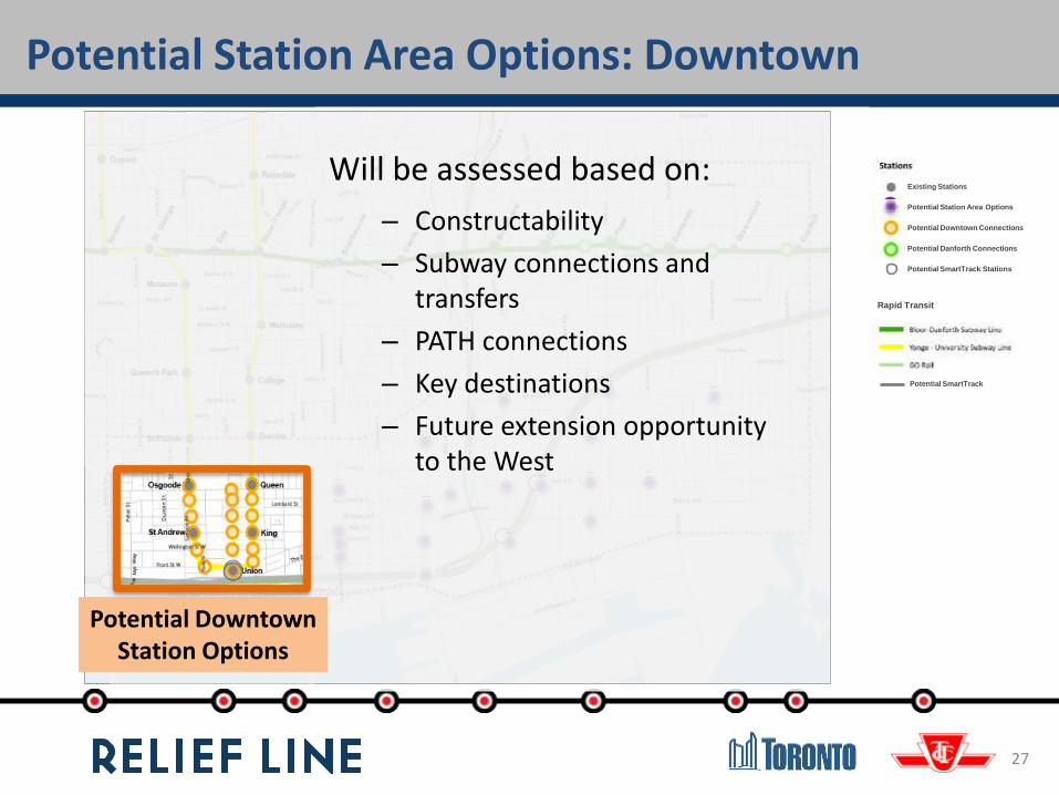
Potential Downtown Station Options
Will be assessed based on:
– Constructability
– Subway connections and transfers
– PATH connections
– Key destinations
– Future extension opportunity to the West
Potential Station Area Options: Downtown

28
Existing Stations
Potential Station Area Options
Potential Downtown Connections
Potential Danforth Connections
Potential SmartTrack Stations
Rapid Transit
Potential SmartTrack
Potential Danforth Subway Connection
Will be assessed based on:
– Neighbourhood fit
– Community impact and benefit
– Ease of transfers from TTC services
– Surface connections and access
– Future extension opportunities to the north
– Constructability
Potential Station Area Options: Danforth Subway

Evaluation Process
29

SERVING PEOPLE
STRENGTHENING PLACES
SUPPORTING PROSPERITY
Evaluation criteria based on principles
and criteria developed during the Official Plan
Review process “Feeling Congested?”
Evaluation Framework
30


Consultation with Public and Stakeholders
• Public meetings: three in the study area and one “city-wide” meeting along the Yonge Subway Line
• Stakeholder Advisory Group meeting
• Online consultation featuring interactive tools
• Pop-up consultations
• Symposium with transit leaders and experts
32
Comment Deadline is March 27, 2015

With the information we receive during this round of public consultation, we will:
• Finalize the evaluation criteria that will be used to determine the route and station locations
• Further assess potential station areas and identify potential corridors
Next Steps
33
• Next round of consultation will focus on the results of the evaluation of potential stationlocations and the corridors

Stay Involved
34


