1, 2.5 or 3D AEM inversion methods for targeting base ...
6
Extended Abstracts - 15 th SAGA Biennial Conference & Exhibition 2017 Page 1 1, 2.5 or 3D AEM inversion methods for targeting base-metal mineral systems in the McArthur Basin, NT? Decisions, decisions… T. Munday 1 , C. Soerensen 2 , S. Schmid 3 & S. Spinks 4 1. CSIRO, Australia, [email protected] 2. CSIRO, Australia, [email protected] 3. CSIRO, Australia, [email protected] 4. CSIRO, Australia, [email protected] BIOGRAPHY Tim Munday is a Research Group Leader in CSIRO Mineral Resources. He leads a research grouping concerned with the development and application of geophysical technologies for exploration through cover. He has over 20 years’ experience in the application of geophysical methods for the characterisation and exploration through and beneath cover, and in groundwater resource assessment. He firmly believes both are inextricably linked areas of study. SUMMARY The McArthur Basin in Australia’s Northern Territory is host to some Tier 1 base metal mineral deposits including the McArthur River Zn-Pb-Ag mine. AEM data are used as a key exploration technology in the search for these mineral systems. A geological interpretation of results arising from the use of different inversion techniques including a 1, 2.5 and 3D methods on a VTEM data set over a structurally complex area about 70kms north of the McArthur mine was undertaken. The targets were conductive mineralised units associated with the Barney Creek Formation. In the study area, 1D smooth model layered Earth inversions appear to map geological variability and structural complexity in greater detail even though the structures are more 3D in nature. Overall, the results from this study suggested that although the model fits were generally good, the derived geological models for the 2.5D and 3D inversions appeared to be either smooth, more simplified versions of geological reality. In one example, the 2.5D inversion results didn’t resolve conductive sedimentary units and/or mineralisation that that drilling suggested was present. We believe an assessment of all inversion approaches benefit greatly from the incorporation of a priori information and independent constraints. Key words: AEM inversion, 1, 2.5 and 3D inversion, Sediment-hosted base metals, McArthur Basin INTRODUCTION The southern McArthur Basin in Australia’s Northern Territory (Figure 1), has been subject to extensive coverage with a range of AEM systems. The potential for time domain EM systems to assist the exploration for base-metal bearing pyritic shale units was recognised in the early 1990s with results emerging from over the McArthur River Zn-Pb-Ag deposit using the QUESTEM and GeoTEM fixed wing, time domain EM systems. Both produced clear anomalies over the deposit (Shalley and Harvey 1992). This success was a spur to the wider acquisition of these data across the McArthur Basin with particular focus on the Batten Fault Zone. AEM systems continue to be employed for exploration throughout the Basin, although the challenges of exploration at depth (>500m) remain a perceived challenge by the exploration community, even though more powerful (higher moment, lower noise) AEM systems are now used routinely. As indicated, exploration targets for AEM systems in the McArthur Group are primarily the pyritic shale-bearing units of the Barney Creek Formation, and their identification was the principal objective for the VTEM AEM survey undertaken over the Caranbirini project area in the Batten Fault Zone; the focus for this study. A total of ~900 line kms of data were acquired along E-W oriented lines across the study area with a line spacing of 200m (Figure 2). Prior geological investigations over the study area indicated the presence of a complex basin architecture with NNW-SSE orientated folds and faults in shale- bearing units of the McArthur Group west of the Emu Fault (Figure 2). 1D Layered Earth Inversion algorithms assume that the earth can be represented by a set of one dimensional layers, extending to an infinite distance in the horizontal plane. However, this assumption has its limits, demonstrating to create artefacts when applied to heterogeneous three dimensional geology (e.g. Ellis, 1998 and Yang and Oldenburg, 2012). In such areas, arguably data from AEM surveys are best interpreted using 2.5D or 3D methods as they better model the physics involved in a decaying EM signal as it diffuses through the earth. Until more recently the prospect of inverting the large volumes characterized by airborne EM datasets was often considered too time consuming given the processing complexities and computational overheads involved in 2.5 and 3D approaches. These challenges have been addressed through, for example, a new forward model algorithm and a new 2.5D inversion solver with adaptive regularisation which allows the incorporation of a misfit to the reference model and the model smoothness function (see Silic et al., 2015), the use of a moving footprint to limit the number of data points required in calculating the large sensitivity matrix needed as input to a 3D inversion at any one location (see Cox et al., 2010), and by partition the forward problem into multiple meshes resulting in a forward modelling mesh that has
Transcript of 1, 2.5 or 3D AEM inversion methods for targeting base ...

Extended Abstracts - 15th SAGA Biennial Conference & Exhibition 2017 Page 1
1, 2.5 or 3D AEM inversion methods for targeting base-metal
mineral systems in the McArthur Basin, NT? Decisions, decisions…
T. Munday1, C. Soerensen2, S. Schmid3 & S. Spinks4
1. CSIRO, Australia, [email protected] 2. CSIRO, Australia, [email protected] 3. CSIRO, Australia, [email protected]
4. CSIRO, Australia, [email protected] BIOGRAPHY Tim Munday is a Research Group Leader in CSIRO Mineral Resources. He leads a research grouping concerned with the development and application of geophysical technologies for exploration through cover. He has over 20 years’ experience in the application of geophysical methods for the characterisation and exploration through and beneath cover, and in groundwater resource assessment. He firmly believes both are inextricably linked areas of study. SUMMARY The McArthur Basin in Australia’s Northern Territory is host to some Tier 1 base metal mineral deposits including the McArthur River Zn-Pb-Ag mine. AEM data are used as a key exploration technology in the search for these mineral systems. A geological interpretation of results arising from the use of different inversion techniques including a 1, 2.5 and 3D methods on a VTEM data set over a structurally complex area about 70kms north of the McArthur mine was undertaken. The targets were conductive mineralised units associated with the Barney Creek Formation. In the study area, 1D smooth model layered Earth inversions appear to map geological variability and structural complexity in greater detail even though the structures are more 3D in nature. Overall, the results from this study suggested that although the model fits were generally good, the derived geological models for the 2.5D and 3D inversions appeared to be either smooth, more simplified versions of geological reality. In one example, the 2.5D inversion results didn’t resolve conductive sedimentary units and/or mineralisation that that drilling suggested was present. We believe an assessment of all inversion approaches benefit greatly from the incorporation of a priori information and independent constraints. Key words: AEM inversion, 1, 2.5 and 3D inversion, Sediment-hosted base metals, McArthur Basin INTRODUCTION
The southern McArthur Basin in Australia’s Northern Territory (Figure 1), has been subject to extensive coverage with a range of AEM systems. The potential for time domain EM systems to assist the exploration for base-metal bearing pyritic shale units was recognised in the early 1990s with results emerging from over the McArthur River Zn-Pb-Ag deposit using the QUESTEM and GeoTEM fixed wing, time domain EM systems. Both produced clear anomalies over the deposit (Shalley and Harvey 1992). This success was a spur to the wider acquisition of these data across the McArthur Basin with particular focus on the Batten Fault Zone. AEM systems continue to be employed for exploration throughout the Basin, although the challenges of exploration at depth (>500m) remain a perceived challenge by the exploration community, even though more powerful (higher moment, lower noise) AEM systems are now used routinely. As indicated, exploration targets for AEM systems in the McArthur Group are primarily the pyritic shale-bearing units of the Barney Creek Formation, and their identification was the principal objective for the VTEM AEM survey undertaken over the Caranbirini project area in the Batten Fault Zone; the focus for this study. A total of ~900 line kms of data were acquired along E-W oriented lines across the study area with a line spacing of 200m (Figure 2). Prior geological investigations over the study area indicated the presence of a complex basin architecture with NNW-SSE orientated folds and faults in shale-bearing units of the McArthur Group west of the Emu Fault (Figure 2). 1D Layered Earth Inversion algorithms assume that the earth can be represented by a set of one dimensional layers, extending to an infinite distance in the horizontal plane. However, this assumption has its limits, demonstrating to create artefacts when applied to heterogeneous three dimensional geology (e.g. Ellis, 1998 and Yang and Oldenburg, 2012). In such areas, arguably data from AEM surveys are best interpreted using 2.5D or 3D methods as they better model the physics involved in a decaying EM signal as it diffuses through the earth. Until more recently the prospect of inverting the large volumes characterized by airborne EM datasets was often considered too time consuming given the processing complexities and computational overheads involved in 2.5 and 3D approaches. These challenges have been addressed through, for example, a new forward model algorithm and a new 2.5D inversion solver with adaptive regularisation which allows the incorporation of a misfit to the reference model and the model smoothness function (see Silic et al., 2015), the use of a moving footprint to limit the number of data points required in calculating the large sensitivity matrix needed as input to a 3D inversion at any one location (see Cox et al., 2010), and by partition the forward problem into multiple meshes resulting in a forward modelling mesh that has

1, 2.5 or 3D AEM inversion for base-metal exploration Munday et al.
Extended Abstracts - 15th SAGA Biennial Conference & Exhibition 2017 Page 2
far fewer cells than the full inversion mesh thereby reducing the bottleneck for 3D AEM inversions (see Yang et al., 2014). In this paper we examine the relative merits of different EM inversion approaches, specifically the results from applying 1D vs 2.5D and 3D methods using algorithms in common use by the exploration community. The intent was to assess their value in mapping the location and extent of conductive parts of the Barney Creek Formation at depth, particularly where the sediment package is known to be faulted and folded. METHOD AND RESULTS Inversion approaches Three inversion approaches were examined. 1D Inversion The 1D inversion scheme AarhusInv (Auken et al., 2015) was used in the Aarhus Workbench to process and invert the VTEM data. The algorithm inverts soundings for a set of 1D models connected through constraints. The inversion requires a data file as well as a model input definition file containing information on starting model, regularization constraints as well as any prior information. For the purposes of this study, a 30 layer model was used for the inversion employing Z component data. The first layer thickness was chosen to be 10m with logarithmically increasing thicknesses to a depth of 1500m, which is the depth of the last layer boundary. The starting model for the inversion was a homogenous halfspace with a resistivity of 40 ohmm. A depth of investigation (DOI) was also defined using the method of Christiansen and Auken (2012). 2.5D Inversion The 2.5D inversion was undertaken by Intrepid Geophysics and has been described by Paterson et al., (2016), and Silic et al., (2015). The inversion application used in this work is a re-engineered version of ArjunAir (Wilson et al., 2006), and it includes a new forward model algorithm and a new 2.5D inversion solver with adaptive regularisation which allows the incorporation of a misfit to the reference model and the model smoothness function. The regularisation parameter is chosen automatically and changed adaptively at each iteration, as the model, the sensitivity and the roughness matrices change (Silic et al., 2015). Z component data were inverted with the inversion using 10m stations, with a 40m (lateral dimension) mesh, and a 5m mesh at surface increasing with depth down to 600m. 3D Inversion The 3D inversion of the Caranbarini VTEM dataset was undertaken by Computational Geosciences Inc., using an adaptive OcTree mesh refinement, where the mesh spans the full computational domain but uses smaller mesh cells around the selected transmitters and receivers. This mesh refinement methodology results in a forward
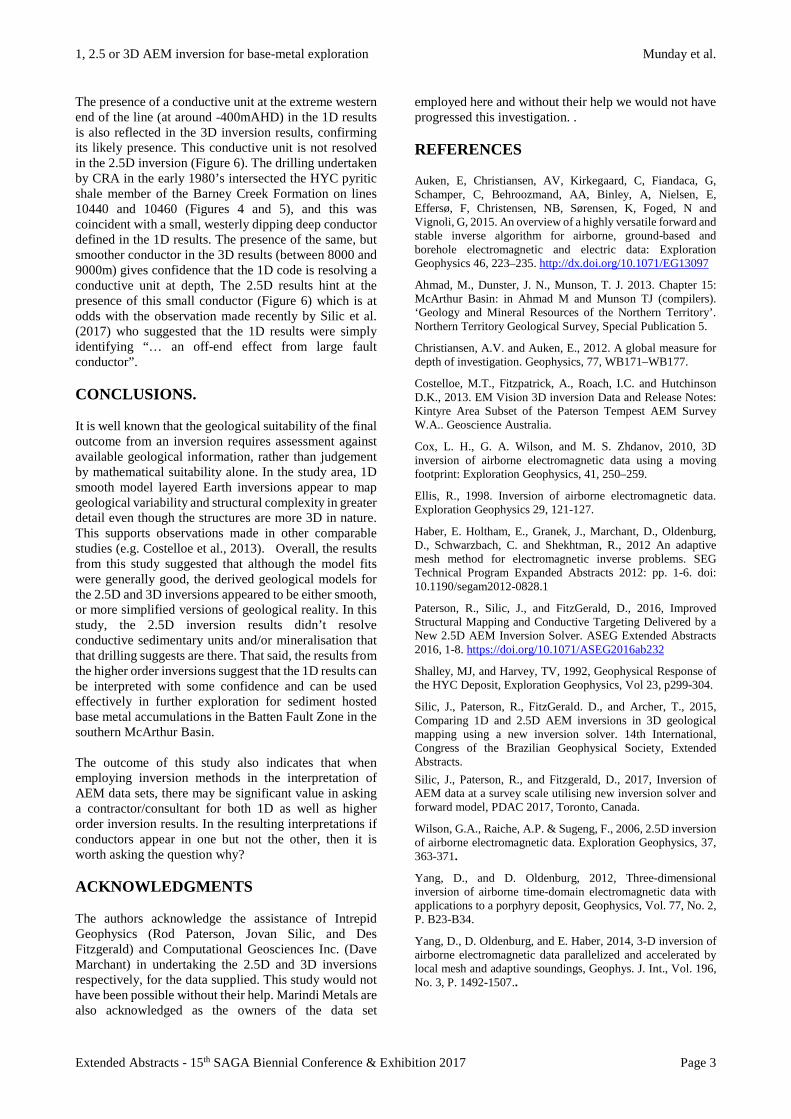
modelling mesh that has far fewer cells than the full inversion mesh. This procedure results in a highly parallel algorithm that can handle large datasets. It builds on the approach described by Haber et al., (2012) and Yang et al., (2014). Results Limited drilling is available in the study area, permitting the geological interpretation of the results generated from the inversions. An example is shown in Figure 3 for DD82CA1 - a diamond hole located just to the west of the Emu Fault on VTEM flight line 10440 (Figure 2). A 1D model for the fiducial closest to the hole suggests that the HYC pyritic shale member of the Barney Creek Formation, and the underlying Teena Dolostone, are conductive. The location of the drillhole and related stratigraphy are shown overlain on a 1D smooth model LEI in Figure 4. The section identifies a very conductive package east of the Emu Fault associated with Cambrian sediments of the Roper Group. West of the Emu Fault, more moderate folded and sub-horizontal conductors are identified between 2000 and 6000m along the line at elevations between -200 and -500mAHD. A deeper highly conductive unit is resolved just above the DOI and experience suggests this conductor may be an artefact. There is no drilling available to confirm this, either on this or adjacent lines. The folded conductors observed in the section for line 10440 (Figure 4) mirror the folds mapped at surface (Figure 2). This suggests that the 1D results are resolving a structurally contorted sediment package that might relate to transpression and uplift of part of the McArthur Group in this location. A similar structure is observed in the flight line further north (Line 10460) (Figure 5). The disruption of the lateral extent of the conductive unit also indicates the presence of growth (?) faults (potentially important conduits for mineralised fluids). The synclinally folded conductor centred at 2500m in Figure 5, might be interpreted at the westward extension of the HYC pyritic shale member of the Barney Creek Formation. Analysis of the results from the 2.5D inversion and the 3D inversion for line 10440 (Figure 6), indicate that the deep laterally extensive conductor defined in the 1D results is not present, supporting the previously discussed interpretation that this may be an artefact. However, both higher order inversions appear to generate a smoothed view of the subsurface, and neither define a folded conductive unit nor the suggestion of syncline centred at ~ 2500m from the west. It has been argued that these are artefacts in the 1D inversion, a consequence of “variable near surface overburden features” (cf Silic et al., 2017), but given their close correspondence with structures mapped at surface, and that the 3D results hint at a folded conductor extending west, we believe they are most likely real.
1, 2.5 or 3D AEM inversion for base-metal exploration Munday et al.
Extended Abstracts - 15th SAGA Biennial Conference & Exhibition 2017 Page 3
The presence of a conductive unit at the extreme western end of the line (at around -400mAHD) in the 1D results is also reflected in the 3D inversion results, confirming its likely presence. This conductive unit is not resolved in the 2.5D inversion (Figure 6). The drilling undertaken by CRA in the early 1980’s intersected the HYC pyritic shale member of the Barney Creek Formation on lines 10440 and 10460 (Figures 4 and 5), and this was coincident with a small, westerly dipping deep conductor defined in the 1D results. The presence of the same, but smoother conductor in the 3D results (between 8000 and 9000m) gives confidence that the 1D code is resolving a conductive unit at depth, The 2.5D results hint at the presence of this small conductor (Figure 6) which is at odds with the observation made recently by Silic et al. (2017) who suggested that the 1D results were simply identifying “… an off-end effect from large fault conductor”. CONCLUSIONS. It is well known that the geological suitability of the final outcome from an inversion requires assessment against available geological information, rather than judgement by mathematical suitability alone. In the study area, 1D smooth model layered Earth inversions appear to map geological variability and structural complexity in greater detail even though the structures are more 3D in nature. This supports observations made in other comparable studies (e.g. Costelloe et al., 2013). Overall, the results from this study suggested that although the model fits were generally good, the derived geological models for the 2.5D and 3D inversions appeared to be either smooth, or more simplified versions of geological reality. In this study, the 2.5D inversion results didn’t resolve conductive sedimentary units and/or mineralisation that that drilling suggests are there. That said, the results from the higher order inversions suggest that the 1D results can be interpreted with some confidence and can be used effectively in further exploration for sediment hosted base metal accumulations in the Batten Fault Zone in the southern McArthur Basin. The outcome of this study also indicates that when employing inversion methods in the interpretation of AEM data sets, there may be significant value in asking a contractor/consultant for both 1D as well as higher order inversion results. In the resulting interpretations if conductors appear in one but not the other, then it is worth asking the question why? ACKNOWLEDGMENTS The authors acknowledge the assistance of Intrepid Geophysics (Rod Paterson, Jovan Silic, and Des Fitzgerald) and Computational Geosciences Inc. (Dave Marchant) in undertaking the 2.5D and 3D inversions respectively, for the data supplied. This study would not have been possible without their help. Marindi Metals are also acknowledged as the owners of the data set
employed here and without their help we would not have progressed this investigation. . REFERENCES Auken, E, Christiansen, AV, Kirkegaard, C, Fiandaca, G, Schamper, C, Behroozmand, AA, Binley, A, Nielsen, E, Effersø, F, Christensen, NB, Sørensen, K, Foged, N and Vignoli, G, 2015. An overview of a highly versatile forward and stable inverse algorithm for airborne, ground-based and borehole electromagnetic and electric data: Exploration Geophysics 46, 223–235. http://dx.doi.org/10.1071/EG13097
Ahmad, M., Dunster, J. N., Munson, T. J. 2013. Chapter 15: McArthur Basin: in Ahmad M and Munson TJ (compilers). ‘Geology and Mineral Resources of the Northern Territory’. Northern Territory Geological Survey, Special Publication 5.
Christiansen, A.V. and Auken, E., 2012. A global measure for depth of investigation. Geophysics, 77, WB171–WB177.
Costelloe, M.T., Fitzpatrick, A., Roach, I.C. and Hutchinson D.K., 2013. EM Vision 3D inversion Data and Release Notes: Kintyre Area Subset of the Paterson Tempest AEM Survey W.A.. Geoscience Australia.
Cox, L. H., G. A. Wilson, and M. S. Zhdanov, 2010, 3D inversion of airborne electromagnetic data using a moving footprint: Exploration Geophysics, 41, 250–259.
Ellis, R., 1998. Inversion of airborne electromagnetic data. Exploration Geophysics 29, 121-127.
Haber, E. Holtham, E., Granek, J., Marchant, D., Oldenburg, D., Schwarzbach, C. and Shekhtman, R., 2012 An adaptive mesh method for electromagnetic inverse problems. SEG Technical Program Expanded Abstracts 2012: pp. 1-6. doi: 10.1190/segam2012-0828.1
Paterson, R., Silic, J., and FitzGerald, D., 2016, Improved Structural Mapping and Conductive Targeting Delivered by a New 2.5D AEM Inversion Solver. ASEG Extended Abstracts 2016, 1-8. https://doi.org/10.1071/ASEG2016ab232
Shalley, MJ, and Harvey, TV, 1992, Geophysical Response of the HYC Deposit, Exploration Geophysics, Vol 23, p299-304.
Silic, J., Paterson, R., FitzGerald. D., and Archer, T., 2015, Comparing 1D and 2.5D AEM inversions in 3D geological mapping using a new inversion solver. 14th International, Congress of the Brazilian Geophysical Society, Extended Abstracts. Silic, J., Paterson, R., and Fitzgerald, D., 2017, Inversion of AEM data at a survey scale utilising new inversion solver and forward model, PDAC 2017, Toronto, Canada.
Wilson, G.A., Raiche, A.P. & Sugeng, F., 2006, 2.5D inversion of airborne electromagnetic data. Exploration Geophysics, 37, 363-371.
Yang, D., and D. Oldenburg, 2012, Three-dimensional inversion of airborne time-domain electromagnetic data with applications to a porphyry deposit, Geophysics, Vol. 77, No. 2, P. B23-B34.
Yang, D., D. Oldenburg, and E. Haber, 2014, 3-D inversion of airborne electromagnetic data parallelized and accelerated by local mesh and adaptive soundings, Geophys. J. Int., Vol. 196, No. 3, P. 1492-1507..

Extended Abstracts - 15th SAGA Biennial Conference & Exhibition 2017 Page 4
Figure 1: Simplified Geological map of the McArthur Basin, divided into lower Tawallah Group, and undifferentiated McArthur and Roper Groups. The locations of the Caranbirini Project area and the McArthur River (HYC) deposit are also indicated. Modified after Ahmad et al. (2013)
Figure 2: Flight line map for VTEM AEM Caranbarini survey overlain on the regional geological map. The survey straddles the Emu Fault which marks the boundary between the Roper Group Sediments in the east and those of the McArthur Group in the west. The latter have been folded and faulted. Two lines of data subject to detailed geological analysis with reference to drill holes DD83CA3 and DD82CA1 are shown in yellow.

1, 2.5 or 3D AEM inversion for base-metal exploration Munday et al.
Extended Abstracts - 15th SAGA Biennial Conference & Exhibition 2017 Page 5
Figure 3: Lithology log (right) and 1D smooth model LEI inversion (left) for a VTEM fiducial closest to drill hole DD82CA1 on flight line 10440. The hole drilled in 1982 by CRA Exploration Pty Ltd targeted a gravity high adjacent to the Emu Fault and logged as McArthur Group stratigraphy. The hole was pre-collared to 288 m and cored to the end of hole at 1000.3 m. The cored stratigraphy consists of Reward Dolostone, Barney Creek Formation and Teena Dolostone. The upper part of the sequence was modelled as a resistor, with the Barney Creek Formation becoming increasingly conductive with depth.
Figure 4: Conductivity depth section for a smooth model 1D LEI of Line 10440, showing a dipping conductor west of the Emu Fault which is intercepted by DD82CA1. Possible westward extensions of the HYC shale member Barney Creek Formation are interpreted to be present between 2000 and 6000m along the line at depths ranging from -200 to -400mAHD. The sequence appears folded and faulted between 4000 and 6000m with a series of antiforms and synforms. These mirror folds mapped at surface (see Figure 2).

1, 2.5 or 3D AEM inversion for base-metal exploration Munday et al.
Extended Abstracts - 15th SAGA Biennial Conference & Exhibition 2017 Page 6
Figure 5: Conductivity depth section for a smooth model 1D LEI of Line 10460, showing a dipping conductor west of the Emu Fault which is intercepted by DD82CA3. Drillhole DD82CA3 was drilled in 1984 by CRA Exploration Pty Ltd and logged as McArthur Group stratigraphy. The cored stratigraphy consists of Lynott Formation, Reward Dolostone and Barney Creek Formation. The interpreted HYC Pyritic Shale member of the Barney Creek Formation was intercepted at a depth of ~540m below the ground surface.
Figure 6: Conductivity-depth sections for line 10440, with results for three inversion approaches shown in the three panels. The top panel (A) is derived from the 1D smooth model inversion using AarhusInv; the middle (B) generated by Intrepid Geophysics using their 2.5D code; and the lower panel (C) using results from CGI’s 3D inversion. The higher order inversion results produce smoother models with both suggesting the conductor at or just above the DOI fitted in the 1D code may be an artefact. The dipping conductor representing Barney Creek Formation sediments intersected by drillhole DD82CA1 (see Figure 4), is also defined in the 3D results (albeit smoothed - between 8000 and 9000m). There is a hint of a conductor in the same position in the 2.5D section. This gives confidence that the 1D codes are resolving a conductive unit at depth, with a sharper definition of the unit.