
· Web view2016 Indiana bat and northern long‐eared bat Programmatic Agreement ... OFFICE OF...
49
OHIO DEPARTMENT OF TRANSPORTATION OFFICE OF ENVIRONMENTAL SERVICES 1980 WEST BROAD STREET MAIL STOP 4170 COLUMBUS, OHIO 43223 (614) 466-7100 LEVEL 3 DRAFT ECOLOGICAL SURVEY REPORT (v. 05-16) The environmental review, consultation, and other actions required by applicable Federal environmental laws for this project are being, or have been, carried-out by ODOT pursuant to 23 U.S.C. 327 and a Memorandum of Understanding dated [December 11, Project C-R-S / Name: Project Identification Number (PID): Report Type: Level 3 Draft ESR Report Author(s): Affiliation: Phone: Email: Date of Submission: Certification (Must be acknowledged by a responsible party) ☐ I certify that I have personally examined and am familiar with the information in this report and all attachments, and that the data collection was supervised by an individual(s) prequalified to conduct ecological surveys for ODOT or by trained ODOT Environmental staff. Based on my inquiry of those persons immediately responsible for obtaining the information contained in the report, I believe that the information has been collected in accordance with the ODOT Ecological Manual current at the time of the report preparation, and is true, accurate, and complete. Name: Insert name of responsible party. Date: Click here to enter a date. Title: Insert title of responsible party.
-
Upload
duongkhanh -
Category
Documents
-
view
213 -
download
0
Transcript of · Web view2016 Indiana bat and northern long‐eared bat Programmatic Agreement ... OFFICE OF...

OHIO DEPARTMENT OF TRANSPORTATIONOFFICE OF ENVIRONMENTAL SERVICES
1980 WEST BROAD STREET MAIL STOP 4170COLUMBUS, OHIO 43223
(614) 466-7100
LEV
EL
3 D
RA
FT
EC
OLO
GIC
AL
SU
RV
EY
R
EP
OR
T (v
. 05-
16)
The environmental review, consultation, and other actions required by applicable Federal environmental laws for this project are being, or have been, carried-out by ODOT pursuant to 23 U.S.C. 327 and a Memorandum of Understanding dated [December 11, 2015], and executed by FHWA and ODOT.
Project C-R-S / Name:
Project Identification Number (PID):
Report Type: Level 3 Draft ESR
Report Author(s):
Affiliation:
Phone:
Email:
Date of Submission:
Certification (Must be acknowledged by a responsible party)☐ I certify that I have personally examined and am familiar with the information in this report and all
attachments, and that the data collection was supervised by an individual(s) prequalified to conduct ecological surveys for ODOT or by trained ODOT Environmental staff. Based on my inquiry of those persons immediately responsible for obtaining the information contained in the report, I believe that the information has been collected in accordance with the ODOT Ecological Manual current at the time of the report preparation, and is true, accurate, and complete.
Name: Insert name of responsible party. Date: Click here to enter a date.
Title: Insert title of responsible party.

DRAFT LEVEL 3 ESR
HOW TO MODIFY TABLES AND FORMATTING IN WORD:
This Level 3 Draft ESR Form contains pull down menus and content controls that will assist an author in filling in the tables. The choices in these pull down menus are the preferred content for the tables.
Deleting Tables:Tables can be deleted from the documents if the resources are not present. For example, if no wetlands were found within the study area, the results summary table should remain, and the wetland table and wetland impact table can be removed from the document. To delete an entire table hover the cursor near the top left corner of the tale and left click the 4-way arrow that appears. Once selected (the table will be highlighted) right click and select cut to remove the table.
Adding Rows or Columns to tables:Tables in the form contain Repeating Selection Content Controls. Rows can be added to a table to accommodate additional features by placing the cursor somewhere in the row to activate the icon at the end of the row. Clicking on this symbol will add a new row for data entry. Rows can also be selected and deleted when appropriate.
Deleting Rows or Columns to tables:Rows can also be selected and deleted when appropriate. In the impacts section, columns can also be added or deleted from the tables to accommodate the number of alternatives. To delete the table rows simply highlight the rows, right click on the mouse, and select “delete cells”. In the dialog box that opens select “delete cells” and then select “Delete entire row” or “Delete entire column”.
Report formatting:Section breaks within the report forms can be removed to condense documents (allowing for more than 1 table per page); however, these section breaks should not be removed between pages with different orientations (portrait vs. landscape). To make the section breaks visible, left click on the “Home” tab and then left click on the icon. This turns on formatting marks.
Spaces have been provided in each table to allow for additional discussion on resources; however, an author can also add text outside of the tables at their discretion.
These forms are the preferred format to use when preparing Ecological Survey Reports; however, any of these forms can be added to or expanded upon if warranted.
DELETE THIS PAGE PRIOR TO FINALIZING THE REPORT.

DRAFT LEVEL 3 ESR
TABLE OF CONTENTS PAGE #PROJECT SUMMARYLITERATURE REVIEWFIELD METHODSDATA COLLECTION RESULTS AND IMPACTS
Aquatic EcologyResults: Streams Impacts: StreamsResults: WetlandsImpacts: WetlandsResults: Potentially Jurisdictional DitchesImpacts: Potentially Jurisdictional DitchesResults: Pond, Lake, Reservoir, Retention/Detention BasinImpacts: Pond, Lake, Reservoir, Retention/Detention BasinResults: Aquatic Life, Fish Results: Aquatic Life, Aquatic Macroinvertebrates Results: Aquatic Life, Mussel Community Impacts: Aquatic Life
Terrestrial EcologyResults: Vegetative Communities Results: Vegetation Impacts: Vegetative Community and Land CoverResults: MammalsResults: BirdsResults: ReptilesResults: AmphibiansImpacts: Wildlife
Listed SpeciesResults: Federally Listed Species Impacts: Federally Listed SpeciesResults: State Listed Species Impacts: State Listed Species
LITERATURE CITEDAPPENDICES

DRAFT LEVEL 3 ESR
PROJECT SUMMARY
LOCATION DATA
ODOT District: Choose an item.
County(ies):
Township(s):
Project Center Latitude (DD.dddd):
Longitude (DD.dddd):
Project Area Size (ac):
PROJECT DESCRIPTION
ECOLOGICAL IMPACT SUMMARY (Impacts may be preliminary and subject to revision)
4

DRAFT LEVEL 3 ESR
LITERATURE REVIEW
Literature Source(s) Reviewed (check all that apply) Results of Review Map Included
In Appendix
Ecoregion Map List Ecoregion(s):(Choose an Ecoregion)(Choose an Ecoregion)
(Choose)
Physiographic Regions Map of OhioList Physiographic Region(s):(Choose Physiographic Region)(Choose Physiographic Region)
(Choose)
USGS 7.5 Minute Topographic Quadrangle Maps
List quadrangle(s): Map Required
County Soil Survey Mapped hydric soils within project area? (Choose)
Map Required
Ohio Water Quality Standards (Ohio Administrative Code, Chapter 3745-1) List stream designations in the Stream Table Not
Applicable
Biological and Water Quality Reports List reports that cover project area (if applicable): Not Applicable
Hydrologic Unit Code(s) (HUC) List 12 Digit Watershed boundaries within project area: (Choose)
Total Maximum Daily Load (TMDL) Program List TMDL status of project area (If applicable): (Choose)
National and State Wild and Scenic River lists, and the Nationwide Rivers Inventory (NRI)
List river(s) within or near the project area (if within applicable reach):(Choose River)(Choose River)
(Choose)
Federal Emergency Management Agency (FEMA) Flood Insurance Rate Maps (FIRM)
Is the project within a 100 year floodplain: (Choose) (Choose)
Ohio’s Coastal Zone Manag ement Area Is the project within the Coastal Zone Management Area: (Choose) (Choose)
National Wetlands Inventory (NWI) and or Ohio Wetland Inventory Mapping (OWI) (Choose)
ODNR Division of Natural Areas and Preserves Natural Heritage Database
Are there records for listed species within 1 mile of the project area? (Choose)Summarize on State Listed Species Table
(Choose)
Federally Endangered, Threatened, Proposed and Candidate Species in Ohio
List and summarize on Federally Listed Species Table
Not Applicable
Ohio Mussel Survey Protocols List streams located in Appendix A and group number on Mussel Table
Not Applicable
Oak Openings Region of Ohio Is the project located within the Oak Openings Region of Ohio? (Choose) (Choose)
ODNR Lands Is the project impacting or adjacent to ODNR property? (Choose) (Choose)
Other
5
Select...
Select...

DRAFT LEVEL 3 ESR
FIELD METHODSField Investigator Name(s):Affiliation:Date(s) of Field Work:Weather Conditions:
Check all that applyStream Survey (Habitat and Biology)
Field Evaluation Manual for Ohio’s Primary Headwater Habitat Streams (v 3.0) (OEPA 2012)
Methods for Assessing Habitat in Flowing Waters: Using the Qualitative Habitat Evaluation Index (QHEI). (OEPA 2006)Biological Criteria for the Protection of Aquatic Life: Volume I (OEPA 1987a), Volume II (OEPA 1987b, 2013a), Volume III (OEPA 1989, 2013b), ODOT Ecological Manual: Sections 2.2.1.1 -Stream, 2.2.1.5-Fishes, 2.2.1.6-Macrobenthos, 2.2.1.7-Mussels (ODOT 2014)
Ohio Mussel Survey Protocols (ODNR and USFWS 2015)
Other Methods (describe and cite):
Wetland Delineation and Classification
Corps of Engineers Wetlands Delineation Manual. Technical Report Y-87-1 (Environmental Laboratory 1987)
Regional Supplement to the Corps of Engineers Wetland Delineation Manual:
Midwest Region (Environmental Laboratory 2010)
Northcentral and Northeast Region (Environmental Laboratory 2012)
Eastern Mountains and Piedmont Region (Environmental Laboratory 2012)
Classification of Wetlands and Deepwater Habitats of the United States (Cowardin et.al. 1979)
Ohio Rapid Assessment Method for Wetlands v. 5.0, User’s Manual and Scoring Forms (OEPA 2001)
Other Methods (describe and cite):
Other Waters
ODOT Ecological Manual: Sections 2.2.1.3-Ditches/Swales, 203.2.1.4-Ponds/Lakes (ODOT 2014)
Other Methods (describe and cite):
TerrestrialODOT Ecological Manual: Section 2.2.2 -Terrestrial Ecology (ODOT 2014)
Other Methods (describe and cite):
Listed SpeciesODOT Ecological Manual: Sections 2.2.3 -Listed Species (ODOT 2014)
Other Methods (describe and cite):
6

DRAFT LEVEL 3 ESR
RESULTS: AQUATIC ECOLOGY - STREAMSWere any streams identified within the project area? (Choose)Total number of streams within the project area: Enter NumberTotal length of streams within the project area (linear feet): Enter Length
STREAM TABLE : RESOURCES IDENTIFIED ON FIGURE(S) Enter Figure #
Stre
am N
ame/
I.D.:
Phot
ogra
ph #
(s):
Rec
eivi
ng W
ater
s:
Dra
inag
e A
rea
(mi2 ):
Ohi
o EP
A R
iver
Mile
(if a
pplic
able
) :
12-D
igit
HU
C:
Tota
l Len
gth
With
in P
roje
ct
Are
a (li
n. ft
.):
Is th
is S
trea
m C
aptu
red
w
ithin
the
Roa
dway
Ditc
h:
*Str
eam
Hyd
rolo
gy T
ype:
ᶧ USA
CE F
low
Ch
arac
teris
tics:
Hab
itat A
sses
smen
t
Evid
ence
of M
usse
ls
Pres
ent:
Biological Sampling Conducted
Ohi
o EP
A Aq
uatic
Life
Use
D
esig
natio
n :
Ant
i-deg
rada
tion
Des
igna
tion:
Nat
iona
l or S
tate
Sce
nic
Riv
ers
or N
RI S
trea
ms
Des
igna
tion
for P
oten
tial
In-w
ater
Wor
k R
estr
ictio
n:
HU
C w
ith a
n A
ppro
ved
or
Pend
ing
TMD
L:
Sala
man
ders
O
bser
ved:
Fish
Obs
erve
d:
Aqu
atic
Mac
ro-
inve
rteb
rate
s O
bser
ved:
(Choose) (Choose)
Non-RPW(Choose)
Enter Score
(Choose) (Choose)
(Choose) (Choose) (Choose) (Choose) (Choose) (Choose) (Choose)
Additional Information. List how the stream connects to a Traditional Navigable Water (TNW) and any other pertinent observations (such as water quality measurements if taken) :
*P = Perennial, I= Intermittent, E = Ephemeral ᶧSubject to verification by the USACE (TNW=Traditional Navigable Water, RPW=Relatively Permanent Water) ᶧᶧ Indicates Provisional designations based on habitat assessment forms and/or HMFEI.
7

DRAFT LEVEL 3 ESR
IMPACTS: AQUATIC ECOLOGY - STREAMSWill any streams be impacts by the project? (Choose)
Total number of streams impacted by the project (list multiple alignments separately): Enter NumberTotal length of streams impacted by the project (feet): Enter Area
STREAM IMPACTS TABLE Alternative Impacts (ft.)
Stream I.D. Use Designation USACE Flow Characteristics Alternative 1 Alternative 2 Alternative 3
(Choose) (Choose) (Choose)
Discuss the type of impact(s) expected to each stream. If a stream is impacted at multiple locations, discuss each location separately and include the distance (stream length) from other impacted locations.
8
Total impacts (ft.)

DRAFT LEVEL 3 ESR
RESULTS: AQUATIC ECOLOGY - WETLANDSWere any wetlands identified within the project area? (Choose)
Total number of wetlands within the project area: Enter NumberTotal area of wetlands within the project area (acres): Enter Area
WETLAND TABLE : RESOURCES IDENTIFIED ON FIGURE(S) Enter Figure #
Wet
land
Nam
e/I.D
.:
Phot
ogra
ph #
(s):
Hyd
rolo
gic
Con
nect
ion:
Rec
eivi
ng W
ater
s (if
non
-isol
ated
):
12-D
igit
HU
C B
ound
ary
the
Wet
land
is L
ocat
ed
with
in:
Loca
ted
With
in a
M
appe
d H
ydric
Soi
l U
nit(s
):
App
roxi
mat
e To
tal S
ize
(ac.
):
Wet
land
Are
a Lo
cate
d w
ithin
the
Proj
ect A
rea
(ac.
):
OR
AM
Ass
essm
ent
Scor
e:
Prov
isio
nal W
etla
nd
Cat
egor
y (
base
d on
O
RA
M):
Kno
wn
Hig
h Q
ualit
y W
etla
nd (f
rom
Nat
ural
H
erita
ge D
atab
ase)
:
Dom
inan
t Wet
land
C
omm
unity
(ies)
Bas
ed
on C
owar
din
(197
9)
Wet
land
Cla
ssifi
catio
ns:
Estim
ated
Hyd
rope
riod
(Cow
ardi
n, 1
979)
(Choose)
(Choose)
Enter Soil
Symbol
Enter
Score
(Choose)(Choose)(Choose)
(Choose)(Choose Additional)(Choose Additional)
(Choose)
(Choose)Additional Information. List How the wetland connects to a Traditional Navigable Water (TNW) if non-isolated, dominant plant species, and any other pertinent observations :
9

DRAFT LEVEL 3 ESR
IMPACTS: AQUATIC ECOLOGY - WETLANDSWill any wetlands be impacted by the project? (Choose)Total number of wetlands impacted by the project Enter NumberTotal area of wetlands impacted by the project (acres): Enter Area
WETLAND IMPACTS TABLE Alternative Impacts (ac)
Wetland I.D. Provisional Wetland Category
Hydrologic Connection Alternative 1 Alternative 2 Alternative 3
(Choose)(Choose)(Choose)
Discuss the types of impact(s) expected to each wetland.
10
Total impacts (ac)

DRAFT LEVEL 3 ESR
RESULTS: AQUATIC ECOLOGY – DITCHESWere any potentially jurisdictional ditches or ditches serving as non-jurisdictional conveyances for adjacent wetlands identified within the project area?
(Choose)
Total number of potentially jurisdictional ditches within the project area: Enter NumberTotal area of potentially jurisdictional ditches within the project area (acres): Enter Area
POTENTIALLY JURISDICTIONAL DITCH TABLE : RESOURCES IDENTIFIED ON FIGURE(S) Enter Figure #(Note: ditches that acquire/possess an ordinary high water mark and become relatively permanent waters outside of right-of-way (upstream) should be assessed as streams and included on the
Stream Table)
Ditc
h I.D
.:
Phot
ogra
ph #
(s):
Rec
eivi
ng W
ater
s:
12-D
igit
HU
C
Bou
ndar
y th
e D
itch
is
Loca
ted
with
in:
USA
CE
Flow
C
hara
cter
istic
s:
OH
WM
Pre
sent
:
Con
stru
cted
Thr
ough
or
Dra
ins
a w
etla
nd:
Con
stru
cted
Thr
ough
a
Map
ped
Hyd
ric S
oil
Uni
t(s):
Flow
s B
etw
een
Two
or M
ore
Pote
ntia
l W
ater
s of
the
US:
Ave
rage
Wid
th o
f W
ette
d Pe
rimet
er
With
in P
roje
ct A
rea
(ft.)
Tota
l Len
gth
With
in
Proj
ect A
rea
(lin.
ft.):
(Choose)(Choose)(Choose)
(Choose)
(Choose)
Enter Soil Symbol
(Choose)Enter Width
Enter
Length
Additional Information. List How the ditch connects to a Traditional Navigable Water (TNW) and any other pertinent observations :
11

DRAFT LEVEL 3 ESR
IMPACTS: AQUATIC ECOLOGY - POTENTIALLY JURISDICTIONAL DITCHESWill any potentially jurisdictional ditches be impacted by the project? (Choose)Total number of potentially jurisdictional ditches impacted by the project: Enter NumberTotal area of potentially jurisdictional ditches impacted by the project (acres): Enter Area
DITCH IMPACS TABLE Alternative Impacts (ac.)
Ditch I.D. Receiving Waters
USACE Flow Characteristics Alternative 1 Alternative 2 Alternative 3
(Choose) (Choose)
Total impacts (ac)
Discuss the types of impact(s) expected to each potentially jurisdictional ditch or non-jurisdictional conveyance for an adjacent wetland resource.
12

DRAFT LEVEL 3 ESR
RESULTS: AQUATIC ECOLOGY – PONDS, LAKES, RESERVOIRS, RETENTION / DETENTION BASINSWere any ponds, lakes, reservoirs and retention/detention basins identified within the project area? (Choose)
Total number of ponds, lakes, reservoirs and retention/detention basins within the project area: Enter NumberTotal area of ponds, lakes, reservoirs and retention/detention basins within the project area (acres): Enter Area
PONDS, LAKES, RESERVOIRS, RETENTION / DETENTION BASINS TABLE : RESOURCES IDENTIFIED ON FIGURE(S) Enter Figure #
Wat
er B
ody
I.D.
Phot
ogra
ph #
(s):
Rec
eivi
ng W
ater
s
12 D
igit
HU
C B
ound
ary
the
Wat
er b
ody
is L
ocat
ed
with
in:
Hyd
rolo
gic
Con
nect
ion:
Type
Func
tion
Func
tioni
ng a
s In
tend
ed?
Loca
ted
With
in a
Map
ped
Hyd
ric S
oil U
nit(s
):
App
roxi
mat
e To
tal S
ize
(ac.
):
Pond
Are
a Lo
cate
d W
ithin
th
e Pr
ojec
t Are
a (a
c.):
(Choose) (Choose) Natural(Choose)
Abandoned (Borrow
Pit/Quarry)(Choose)
(Choose)
Enter Soil Symbol
Additional Information. List How the water body connects to a Traditional Navigable Water (TNW) and any other pertinent observations :
13

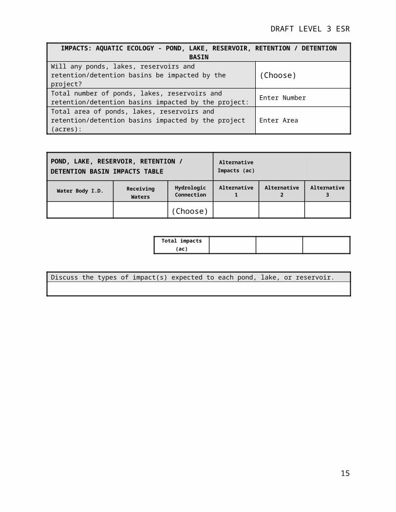
DRAFT LEVEL 3 ESR
IMPACTS: AQUATIC ECOLOGY - POND, LAKE, RESERVOIR, RETENTION / DETENTION BASIN Will any ponds, lakes, reservoirs and retention/detention basins be impacted by the project? (Choose)
Total number of ponds, lakes, reservoirs and retention/detention basins impacted by the project: Enter NumberTotal area of ponds, lakes, reservoirs and retention/detention basins impacted by the project (acres): Enter Area
POND, LAKE, RESERVOIR, RETENTION / DETENTION BASIN IMPACTS TABLE
Alternative Impacts (ac)
Water Body I.D. Receiving WatersHydrologic Connection Alternative 1 Alternative 2 Alternative 3
(Choose)
Total impacts (ac)
Discuss the types of impact(s) expected to each pond, lake, or reservoir.
14
DRAFT LEVEL 3 ESR
RESULTS: AQUATIC ECOLOGY – AQUATIC LIFE, FISHWere any fish communities sampled/observed within the project area? (Choose)
If yes, total number of fish species identified: Enter Number
FISH TABLE (Species Characteristics from OEPA, 2013a)
Scientific Name Common Name Feeding Guild: Breeding Guild: Pollution Tolerance:
Federally Listed:
State Listed:
Declining Species (OAC
3745-1-05, Table 5-2):
Observed in Stream(s) (Include
Quantity):
(Choose) ---(Choose) ---(Choose)---(Choose)
(Choose) (Choose)
General Fish Community Observations:
15

DRAFT LEVEL 3 ESR
RESULTS: AQUATIC ECOLOGY – AQUATIC LIFE, AQUATIC MACROINVERTEBRATES (NOT INCLUDING MUSSELS)
Were any aquatic macroinvertebrate communities sampled / observed within the project area? (Choose)
If yes, total number of aquatic macroinvertebrate species identified: Enter Number
AQUATIC MACROINVERTEBRATE TABLETaxa Observed Observed in Stream(s) (Include Quantity) :
Additional Aquatic Macroinvertebrate Community Observations:
16

DRAFT LEVEL 3 ESR
RESULTS: AQUATIC ECOLOGY – AQUATIC LIFE, MUSSELSStreams ≥ 10 mi2? (Choose)Were any mussel communities sampled /observed within the project area? (Provide appropriate documentation in the Mussel Table) (Choose)
MUSSEL TABLE
Stream Name:Group Listing: (Choose)
Evidence of Mussels: (Choose)
Level of Effort: (Choose)
Documentation Attached:(Choose)
Summary of Results:
17

DRAFT LEVEL 3 ESR
IMPACTS: AQUATIC ECOLOGY - AQUATIC LIFEDiscuss the expected impacts to aquatic fauna (fish, mussels, aquatic macroinvertebrates). Specific stream locations should be referenced when appropriate.
IMPACTS: AQUATIC ECOLOGY - OTHER WATER QUALITY IMPACTSDiscuss potential short term and long term water quality impacts that are likely expect to occur as a result of the proposed project.
Discuss how the project will be implemented to minimize these water quality impacts.Short term water quality impacts resulting from runoff from disturbed areas during construction will be minimized through the use of sediment and erosion controls in accordance with the ODOT Construction and Materials Specifications. Longer duration water quality impacts associated with roadway runoff will be minimized through the implementation of post-construction best management practices in accordance with the ODOT Location and Design Manual.
18

DRAFT LEVEL 3 ESR
RESULTS: TERRESTRIAL ECOLOGY - VEGETATIVE COMMUNITIESList the number of distinct vegetative communities identified within the project area Enter NumberWere any unique or high quality terrestrial habitats identified within the project area? (Choose)
VEGETATIVE COMMUNITIES AND LAND COVER TABLE
Vegetation and Land Cover Areas Identified on Figure(s) Enter Figure #
Vegetative Communities and Land Cover found within the project area:
Degree of Man Induced Ecological Disturbance (based on descriptions in Andreas et. al., 2004)
Unique, Rare, or High Quality?
Acres Within Study Area
(Choose)Other - enter two letter code and description(Choose)
Extreme Disturbance/Ruderal Community (dominated byopportunistic invaders or native highly tolerant taxa)(Choose)
Enter Acres
Community Description (list dominant species, include Anderson (1982) community classification if applicable):
19

DRAFT LEVEL 3 ESR
VEGETATION TABLE
Scientific Name: Common Name: Federally Listed: State Listed:
Location (use vegetative
community codes):
(Choose) (Choose)
Additional Vegetation Observations:
20

DRAFT LEVEL 3 ESR
IMPACTS: TERRESTRIAL ECOLOGY - VEGETATIVE COMMUNITY AND LAND COVER IMPACTSWill any vegetative communities be impacted by the project? (Choose)
Total number of vegetative communities impacted by the project: Enter NumberTotal area of vegetative communities impacted by the project (acres): Enter AreaDescribe any impacts to vegetative communities (with emphasis on rare or unique communities) from an ecological perspective:
VEGETATIVE COMMUNITY AND LAND COVER IMPACTS TABLE
Alternative Impacts
(ac)
Vegetative Community Disturbance LevelUnique, Rare,
or High Quality
Alternative 1
Alternative 2
Alternative 3
(Choose)Other - enter description(Choose)
Extreme Disturbance/Ruderal Community(Choose)
Total impacts
21

DRAFT LEVEL 3 ESR
RESULTS: TERRESTRIAL ECOLOGY - MAMMALSWere any mammals observed within the project area? (Choose)
If yes, total number of species identified: Enter Number
MAMMAL TABLE
Scientific Name Common Name Federally Listed:
State Listed:
Location (use vegetative community codes):
(Choose). (Choose)
Additional Mammal Observations:
22

DRAFT LEVEL 3 ESR
RESULTS: TERRESTRIAL ECOLOGY - BIRDSWere any birds observed within the project area? (Choose)If yes, total number of bird species identified: Enter Number
BIRD TABLE
Scientific Name Common Name Date of Observation
Typical Ohio Range
Federally Listed:
State Listed:
Location (use vegetative
community codes):
Click here to enter a date.
(Choose)
Year-Round Resident(Choose)
(Choose)
Additional Bird Observations:
23

DRAFT LEVEL 3 ESR
RESULTS: TERRESTRIAL ECOLOGY - REPTILESWere any reptiles observed within the project area? (Choose)If yes, total number of reptile species identified: Enter Number
REPTILE TABLE
Scientific Name Common Name Federally Listed:
State Listed:
Location (use vegetative community
codes):
(Choose) (Choose)
Additional Reptile Observations:
24

DRAFT LEVEL 3 ESR
RESULTS: TERRESTRIAL ECOLOGY - AMPHIBIANSWere any amphibian communities sampled/observed within the project area? (Choose)
If yes, total number of amphibian species identified: Enter Number
AMPHIBIAN TABLE
Scientific Name Common Name Federally Listed:
State Listed:
Location (use vegetative community codes):
(Choose) (Choose)
Additional Amphibian Observations:
25

DRAFT LEVEL 3 ESR
IMPACTS: TERRESTRIAL ECOLOGY - WILDLIFEDiscuss any terrestrial habitat alternations that may result from construction activities:
Discuss the expected duration of the impacts (temporary/short term or permanent/long-term):
Discuss if the project impacts would result in the likely extirpation of any taxa from the area:
Include a general discussion of impacts to terrestrial fauna (mammals, birds, reptiles, and amphibians):
26

DRAFT LEVEL 3 ESR
RESULTS: FEDERALLY LISTED SPECIESWere any federally listed species observed within the project area? (Choose)
Were any suitable habitats for federally listed species (known to be within the range of the project area) observed within the project area? (Choose)
Were any proposed or designated critical habitats for federally listed species present within the project area? (Choose)
FEDERALLY LISTED SPECIES Species Name: Indiana Bat (Myotis sodalis) and Northern Long-eared Bat (Myotis septentrionalis)
Listing Status: Endangered/Threatened
Effect Determination (Completed by
ODOT-OES):(Choose)
Suitable Habitat: The 2016 PBO defines suitable wooded habitat (SWH) for these species as any tree covered area that is 0.2 ha (0.5 ac) or larger, containing any potential roosts (i.e., live trees and/or snags ≥3 inches dbh that have exfoliating bark, cracks, crevices, and/or cavities) greater than 4 m (13 ft) tall and at least 7.6 cm (3 in) dbh, or any patch of trees with these characteristics that is less than ½ acre in size but is within 1,000 feet of or connected by a travel corridor to a PMRT, ½-acre or larger stand of SWH, or any patch of wooded riparian buffer. Additionally these species may use bridges over streams as summer roosting habitat. During the winter months these species inhabit hibernacula during the winter months (typically caves, or abandoned mines that provide cool, humid, stable conditions for hibernation).Complete Indiana Bat and Northern Long-eared Bat Field Habitat Assessment Checklist in its entirety and provide a brief discussion including impacts to suitable habitat:
Species Name: Bald Eagle (Haliaeetus leucocephalus)
Listing Status: Species of Concern
Effect Determination (Completed by
ODOT-OES):(Choose)
Is a known nest (based on NHDB or other source) located within 0.5 mile of the project?: (Choose) Will the project
require blasting?: (Choose)Based on field surveys and/or a NHDB record search, is a nest within 660 ft. and/or visible from the project or activity area? If yes, indicate proximity to construction limits:
(Choose)
Suitable Habitat: The bald eagle is protected under the Bald and Golden Eagle Protection Act which prohibits taking bald eagles, including disturbance. The preferred habitat includes mature forests adjacent to open water for nesting and foraging.Discussion Including Impacts to Suitable Habitat:
Species Name: Listing Status: (Choose)
Effect Determination (Completed by
ODOT-OES):(Choose)
Suitable Habitat Description:
Discussion Including Impacts to Suitable Habitat:
Additional Information:
27

DRAFT LEVEL 3 ESR
IMPACTS: FEDERALLY LISTED SPECIESWill any federally listed species or suitable habitat for federally listed potentially be impacted by the project? (Choose)
Will any proposed or designated critical habitats potentially be impacted by the project? (Choose)
FEDERALLY ENDANGERED INDIANA BAT AND FEDERALLY THREATENEDNORTHERN LONG-EARED BAT IMPACT TABLE
Alternative I.D.
Impacts to SWH within 100 ft. of edge of roadway pavement (ac)
Impacts to SWH >100 ft. from edge of roadway pavement (ac)
Potential Impacts to PMRTs located >100 ft. from edge of roadway pavement (#)
Consultation Category (Completed by ODOT-OES)
Anticipated Impacts(Completed by ODOT-OES)
Alternative Enter ID (Choose) (Choose)
Discussion of Impacts:
FEDERALLY LISTED SPECIES IMPACT TABLE (List Each Species Within the County/Range)
Effect Determination(Completed by ODOT-OES)
Scientific Name Common Name Listing Alternative 1 Alternative 2 Alternative 3
(Choose) (Choose) (Choose) (Choose)
Discuss the justification for any project activities that may result in impacts to federally listed species.
28

DRAFT LEVEL 3 ESR
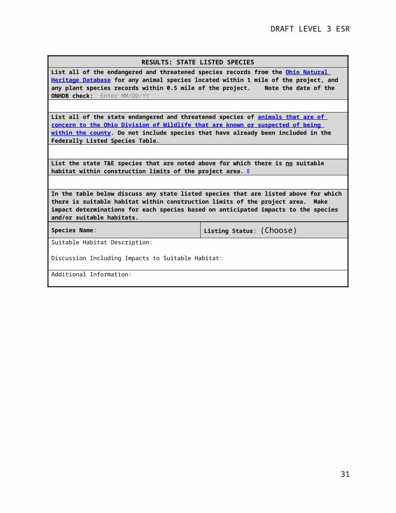
RESULTS: STATE LISTED SPECIESList all of the endangered and threatened species records from the Ohio Natural Heritage Database for any animal species located within 1 mile of the project, and any plant species records within 0.5 mile of the project. Note the date of the ONHDB check: Enter MM/DD/YY
List all of the state endangered and threatened species of animals that are of concern to the Ohio Division of Wildlife that are known or suspected of being within the county. Do not include species that have already been included in the Federally Listed Species Table.
List the state T&E species that are noted above for which there is no suitable habitat within construction limits of the project area.
In the table below discuss any state listed species that are listed above for which there is suitable habitat within construction limits of the project area. Make impact determinations for each species based on anticipated impacts to the species and/or suitable habitats.
Species Name: Listing Status: (Choose)
Suitable Habitat Description:
Discussion Including Impacts to Suitable Habitat:
Additional Information:
29

DRAFT LEVEL 3 ESR
IMPACTS: STATE LISTED SPECIESWill any state listed species potentially be impacted by the project? (Choose)
STATE LISTED SPECIES IMPACT TABLE (List Each Species Found Within or Known to be Within 1 Mile of the Project Area)
Anticipated Impacts
Scientific Name Common Name Listing Alternative 1 Alternative 2 Alternative 3
(Choose) (Choose) (Choose) (Choose)
Discuss the justification for any project activities that may result in impacts to state listed species.
30
DRAFT LEVEL 3 ESR
LITERATURE CITED
Anderson, D. M. 1982, unpublished. Plant communities of Ohio: a preliminary classification anddescription. Division of Natural Areas and Preserves, Ohio Department of NaturalResources, Columbus. 183p. Unpublished.
Andreas, B. K., J.J Mack, and J.S. McCormac. 2004. Floristic Quality Assessment Index (FQAI) for vascular plants and mosses for the State of Ohio. Ohio Environmental Protection Agency, Division of Surface Water, Wetland Ecology Group, Columbus, Ohio. 219 p.
Cowardin, L. M., V. Carter, F.C. Golet, and E. T. LaRoe. 1979. Classification of Wetlands and Deepwater Habitats of the United States. U.S. Fish and Wildlife Service. Biological Services Program Rept. FWS/OBS-79/31. 103 p.
Environmental Laboratory. 1987. Corps of Engineers Wetlands Delineation Manual. Technical Report Y-87-1, U.S. Army Engineer Waterways Experiment Station, Vicksburg, MS.
_____. 2010. Regional Supplement to the Corps of Engineers Wetland Delineation Manual: Midwest Region (Version 2.0). ERDC/EL TR-10-16, U.S. Army Engineer Research and Development Center, Vicksburg, MS.
_____. 2012. Regional Supplement to the Corps of Engineers Wetland Delineation Manual: Eastern Mountains and Piedmont Region (Version 2.0). ERDC/EL TR-12-9. U.S. Army Engineer Research and Development Center, Vicksburg, MS.
_____. 2012. Regional Supplement to the Corps of Engineers Wetland Delineation Manual: Northcentral and Northeast Region (Version 2.0). ERDC/EL TR-12-1. U.S. Army Engineer Research and Development Center, Vicksburg, MS.
Ohio Bird Records Committee (OBRC). 2004. Annotated Checklist of Ohio’s Birds. Columbus, OH. Available at: http://ohiobirds.org/wp-content/uploads/2015/11/OBRClist.pdf
Ohio Department of Transportation (ODOT). 2014. Ecological Manual. Columbus, OH. Available at: http://www.dot.state.oh.us/Divisions/Planning/Environment/Ecological_Resources_Permits/Ecology/Pages/MANUALSANDFORMS.aspx
Ohio Department of Natural Resources (ODNR), Division of Wildlife U.S. Fish and Wildlife Service (USFWS). 2015 Ohio Mussel Survey Protocols. Columbus, OH.
Ohio Environmental Protection Agency (OEPA). 1987a. Biological Criteria for the Protection of Aquatic Life: Volume I, The Role of Biological Data in Water Quality Assessment. Division of Water Quality Monitoring and Assessment, Surface Water Section, Columbus, OH.
_____. 1987b. Biological Criteria for the Protection of Aquatic Life: Volume II, Users Manual for Biological Field Assessment of Ohio Surface Waters. Division of Water Quality Monitoring and Assessment, Surface Water Section, Columbus, OH.
_____. 1989. Biological Criteria for the Protection of Aquatic Life: Volume III, Standardized Biological Field Sampling and Laboratory Methods for Assessing Fish and Macroinvertebrate Communities. Division of Water Quality Monitoring and Assessment, Surface Water Section, Columbus, OH.
_____. 2001. Ohio Rapid Assessment Method for Wetlands v. 5.0, User’s Manual and Scoring Forms. Ohio EPA Technical Report WET/2001-1. Ohio EPA, Division of Surface Water. Columbus, Ohio.
31

DRAFT LEVEL 3 ESR
_____. 2006. Methods for Assessing Habitat in Flowing Waters: Using the Qualitative Habitat Evaluation Index (QHEI). OHIO EPA Technical Bulletin EAS/2006-06-1. Ecological Assessment Section, Division of Surface Water Groveport, OH.
_____. 2012. Field Evaluation Manual for Ohio’s Primary Headwater Habitat Streams (v 3.0). Ohio EPA, Division of Surface Water. Columbus, Ohio.
_____. 2013a. Updates to Biological Criteria for the Protection of Aquatic Life: Volume II and Volume II Addendum. Users Manual for Biological Field Assessment of Ohio Surface Waters. Ecological Assessment Section, Division of Surface Water Groveport, OH.
_____. 2013b. Updates to Biological Criteria for the Protection of Aquatic Life: Volume III. Standardized Biological Field Sampling and Laboratory Methods for Assessing Fish and Macroinvertebrate Communities. Ecological Assessment Section, Division of Surface Water Groveport, OH.
32

DRAFT LEVEL 3 ESR
APPENDICIES
1- Figures
Project Location Mapping
Literature Review Mapping Results
Ecological Resource Mapping
Other (List):
2 - Photographs
Photograph Location Map
Photographs
3 - Data Forms
Stream Characterization/Assessment Data Forms
Wetland Characterization/Assessment Data Forms
Ohio Mussel Habitat Assessment Form
Indiana Bat Habitat Characterization Worksheet
Other (List):
4 – Agency Data RequestsODNR, Division of Natural Areas and Preserves – Natural Heritage Database Information Request
USFWS – Federally Listed Species Information Request
Other (List):
5 – Supporting Survey Reports
Other (List):

DRAFT LEVEL 3 ESR
APPENDIX 1Figures

DRAFT LEVEL 3 ESR
Appendix 2Photographs

DRAFT LEVEL 3 ESR
Appendix 3Data Forms

Ohio Mussel Habitat Assessment Form
Project Information
Project Name:
County: Township:
Latitude (DD.DDDD): Longitude (DD.DDDD):
Stream Name: Group # (From Appendix A):
Methods
Name of Surveyor(s):
Qualification of Surveyor(s): ☐ USFWS Approved ☐ ODNR Approved ☐ Aquatic Biologist (minimum)
Date of Survey: Distance Surveyed (ft.):Total Survey Time (min. x people): Scientific Collector’s Permit Number(s):
Note any deviations from the Ohio Mussel Habitat Assessment Methods :
Habitat Description of Survey Area
Drainage Area at Survey Location (mi2): Water Temp. (oF): Air Temp. (oF):
Substrate Types (include %):
☐ Boulder ☐ Gravel ☐ Bedrock ☐ Detritus ☐ Silt
☐Cobble ☐ Sand ☐ Hardpan ☐ Muck ☐ Artificial
Water Level: ☐ High ☐ Up ☐ Normal ☐ Low ☐Dry/Interstitial
Visibility: ☐ 0-15 cm ☐ 15-30 cm ☐ 30-50 cm ☐ >50 cm ☐ Visible to Bottom
Average Depth (cm): Riffle Run Pool
Max Depth (cm): Riffle Run Pool

Evidence of Mussels: Presence of fresh dead mussel shells and living mussels will trigger a full mussel survey☐ None ☐ Mussel Shell
Only - Subfossil☐ Mussel Shell Only – Weathered Dead
☐ Mussel Shell – Fresh Dead
☐ Living Mussels
ResultsSite Sketch. Approximate numbers and locations of shells and live mussels. Include species list if possible.
Required Attachments 1) Location Map and 2) Photo Log

Indiana Bat and Northern Long-eared Bat Field Habitat Assessment Checklist
PROJECT INFORMATIONCRS: PID:Date:
MANAGEMENT UNITEastern MU ☐Western MU ☐
BAT RECORD SEARCHIs project in a known bat buffer? Yes ☐ No☐Record type(s) (color)?Additional Info including date of records request:
BRIDGE HABITAT ASSESSMENTWill Project Impact a Bridge over a stream? Yes ☐ No ☐Bridge Inspection Conducted? Yes ☐ No ☐Results of Inspection including date:
SUITABLE WOODED HABITAT ASSESSMENTWill Project Impact Suitable Wooded Habitat (SWH)? Yes ☐ No ☐Is all SWH to be impacted within 100 feet of the roadway? If yes, just fill out Line 1. If no, fill out all lines.
Yes ☐ No ☐
Line 1. Acreage of SWH within 100 feet of the roadway ac.Line 2. Acreage of impacted SWH within 50 feet of a perennial stream but outside 100 feet of the roadway.
ac.
Line 3. Acreage of impacted SWH further than 100 feet of the edge of the roadway and not located within 50 feet of a perennial stream.
ac.
Line 4. Number of impacted PMRTs further than 100 feet of the edge of the roadway. Fill out PMRT table if PMRTs will be impacted.

Potential Maternity Roost Tree Determination Form – For use on SWH impacts beyond 100 feet from edge of pavement.
Project CRS Examiner Date of
ObservationsProject Area (ac)
Tree ID #
dbh in inches Species Condition
Crevice, split, or cavity
present?Y/N
% loose bark
above 4 m (13 ft)
Approx. hours of solar exposure
Located with GPS
Y/N

ODOT Bridge Bat Inspection FormOnly bridges spanning 20 feet and located over water require investigation. Refer to 2016 Indiana bat and northern long eared bat ‐Programmatic Agreement/Programmatic Biological Opinion (PA/PBO) –Technical Guidance for details on completing the form.
Project C-R-S: ODOT PID: Date of Inspection: Structure C-R-S: Inspector(s): Water Body:
Factors Affecting Habitat Suitability for Bats (Check all that apply) ☐ Bridge shows signs of frequent flooding (flood debris trapped under the deck in the substructure)☐ Human disturbance or traffic under the bridge. Indicate Intensity: ☐ High ☐ Medium ☐ Low ☐ Lack of quality flight corridor upstream and downstream of bridge (densely vegetated, obstructed, or lacking any
riparian corridor)☐ Other (describe):
Areas Associated with the Bridge and Inspected (Check all that apply) ☐ The underside of the bridge does not contain any areas that could be used for roosting bats☐ All vertical crevices sealed at the top, 0.5-1.25” wide, and ≥4” deep☐ All crevices >12” deep & not sealed☐ All guardrails☐ All expansion joints☐ Spaces between concrete end walls and the bridge deck☐ Crevices, rough surfaces or imperfections in concrete☐ Bird nests☐ Other suitable areas (describe):
Results of Observations for Bats (Check all that apply) ☐ Bats visually observed - Bats flying or roosting.☐ Sounds - High pitched squeaking or chirping. Note location.☐ Droppings/Guano - Small (mouse-like in appearance but less regular) brown or black pellets (older droppings may
be gray). Will accumulate on the ground, floor of a covered bridge or on structural components below where bats roost. Droppings may also adhere to support beams and walls below roosts.
☐ Staining from bat urine – Urine stains may appear wet and are usually found in dark places. Look for four to six inch wide dark stains located on concrete support beams and walls immediately below the ceiling of the bridge, and beneath joints. Do not include staining resulting from water and roadway runoff.
☐ Other evidence (describe):
Additional Notes (e.g., number & species of bats, if known):

Appendix 4Agency Data Requests

Appendix 5Supporting Survey Reports


![DIGITAL MARKETING BATTLES: BAT-EARED FOXMAN VS. SUPERDUDE [INFOGRAPHIC]](https://static.fdocuments.net/doc/165x107/5881d4661a28ab331a8b6027/digital-marketing-battles-bat-eared-foxman-vs-superdude-infographic.jpg)