Technical Report 3: Plan Development & Cost Feasible Projects · Plan Development & Cost Feasible...
57
315 East Robinson Street, Suite 355, Orlando, FL 32801 | 407-481-5672 www.metroplanorlando.com | MetroPlan Orlando | @metroplan_orl 2040 Long Range Transportation Plan Technical Report 3: Plan Development & Cost Feasible Projects Adopted -January 2016 Updated – August 2016
Transcript of Technical Report 3: Plan Development & Cost Feasible Projects · Plan Development & Cost Feasible...
315 East Robinson Street, Suite 355, Orlando, FL 32801 | 407-481-5672
www.metroplanorlando.com | MetroPlan Orlando | @metroplan_orl
2040 Long Range Transportation Plan
Technical Report 3:
Plan Development & Cost Feasible Projects
Adopted -January 2016 Updated – August 2016
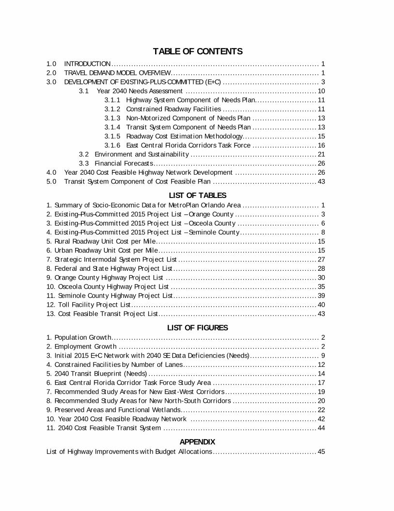
TABLE OF CONTENTS
1.0 INTRODUCTION .................................................................................... 1 2.0 TRAVEL DEMAND MODEL OVERVIEW ............................................................ 1 3.0 DEVELOPMENT OF EXISTING-PLUS-COMMITTED (E+C) ....................................... 3 3.1 Year 2040 Needs Assessment ..................................................... 10 3.1.1 Highway System Component of Needs Plan......................... 11 3.1.2 Constrained Roadway Facilities ...................................... 11 3.1.3 Non-Motorized Component of Needs Plan .......................... 13 3.1.4 Transit System Component of Needs Plan .......................... 13 3.1.5 Roadway Cost Estimation Methodology.............................. 15 3.1.6 East Central Florida Corridors Task Force .......................... 16 3.2 Environment and Sustainability ................................................... 21 3.3 Financial Forecasts .................................................................. 26 4.0 Year 2040 Cost Feasible Highway Network Development ................................. 26 5.0 Transit System Component of Cost Feasible Plan .......................................... 43
LIST OF TABLES 1. Summary of Socio-Economic Data for MetroPlan Orlando Area ............................... 1 2. Existing–Plus–Committed 2015 Project List – Orange County .................................. 3 3. Existing–Plus–Committed 2015 Project List – Osceola County ................................. 6 4. Existing–Plus–Committed 2015 Project List – Seminole County ................................ 8 5. Rural Roadway Unit Cost per Mile ................................................................. 15 6. Urban Roadway Unit Cost per Mile ................................................................ 15 7. Strategic Intermodal System Project List ........................................................ 27 8. Federal and State Highway Project List .......................................................... 28 9. Orange County Highway Project List ............................................................. 30 10. Osceola County Highway Project List ........................................................... 35 11. Seminole County Highway Project List .......................................................... 39 12. Toll Facility Project List ........................................................................... 40 13. Cost Feasible Transit Project List................................................................ 43
LIST OF FIGURES 1. Population Growth .................................................................................... 2 2. Employment Growth ................................................................................. 2 3. Initial 2015 E+C Network with 2040 SE Data Deficiencies (Needs) ............................ 9 4. Constrained Facilities by Number of Lanes ...................................................... 12 5. 2040 Transit Blueprint (Needs) .................................................................... 14 6. East Central Florida Corridor Task Force Study Area .......................................... 17 7. Recommended Study Areas for New East-West Corridors ..................................... 19 8. Recommended Study Areas for New North-South Corridors .................................. 20 9. Preserved Areas and Functional Wetlands ....................................................... 22 10. Year 2040 Cost Feasible Roadway Network ................................................... 42 11. 2040 Cost Feasible Transit System .............................................................. 44
APPENDIX List of Highway Improvements with Budget Allocations .......................................... 45
1
2040 Long Range Transportation Plan: Technical Report 3
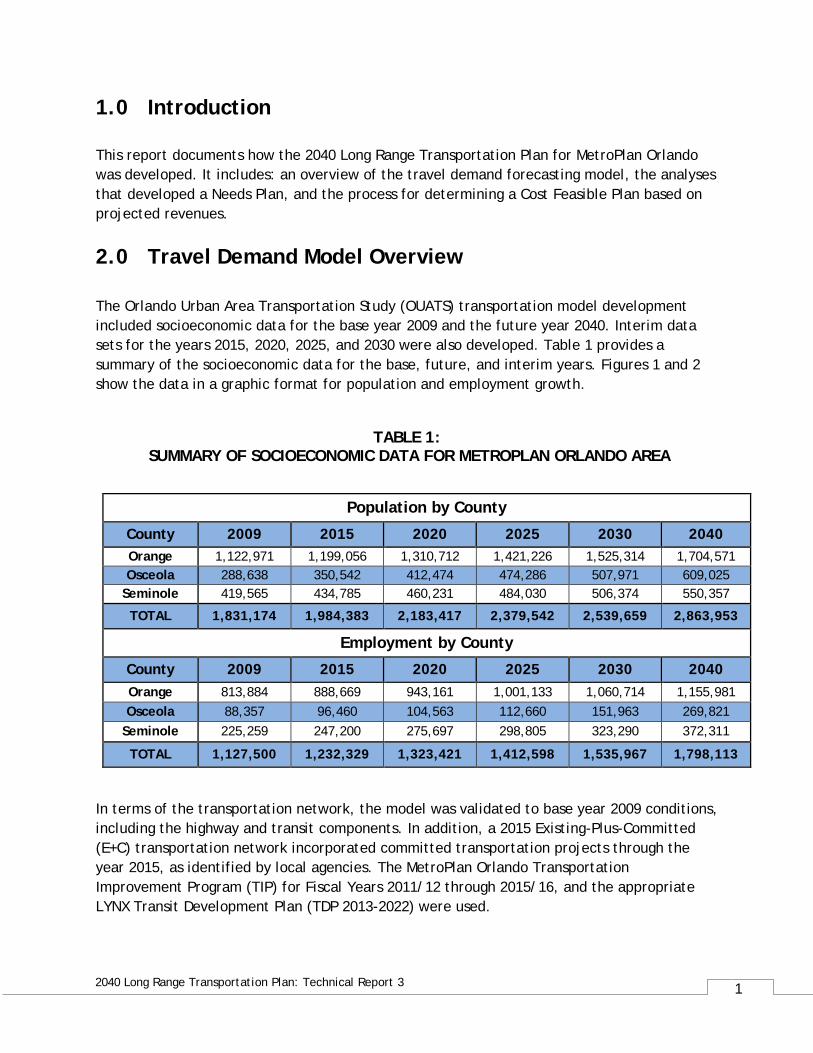
1.0 Introduction This report documents how the 2040 Long Range Transportation Plan for MetroPlan Orlando was developed. It includes: an overview of the travel demand forecasting model, the analyses that developed a Needs Plan, and the process for determining a Cost Feasible Plan based on projected revenues.
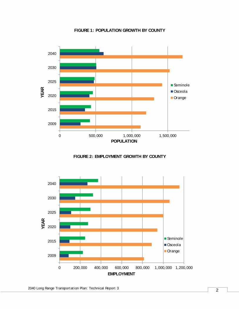
2.0 Travel Demand Model Overview The Orlando Urban Area Transportation Study (OUATS) transportation model development included socioeconomic data for the base year 2009 and the future year 2040. Interim data sets for the years 2015, 2020, 2025, and 2030 were also developed. Table 1 provides a summary of the socioeconomic data for the base, future, and interim years. Figures 1 and 2 show the data in a graphic format for population and employment growth.
TABLE 1: SUMMARY OF SOCIOECONOMIC DATA FOR METROPLAN ORLANDO AREA
Population by County
County 2009 2015 2020 2025 2030 2040 Orange 1,122,971 1,199,056 1,310,712 1,421,226 1,525,314 1,704,571 Osceola 288,638 350,542 412,474 474,286 507,971 609,025
Seminole 419,565 434,785 460,231 484,030 506,374 550,357
TOTAL 1,831,174 1,984,383 2,183,417 2,379,542 2,539,659 2,863,953
Employment by County
County 2009 2015 2020 2025 2030 2040 Orange 813,884 888,669 943,161 1,001,133 1,060,714 1,155,981 Osceola 88,357 96,460 104,563 112,660 151,963 269,821
Seminole 225,259 247,200 275,697 298,805 323,290 372,311
TOTAL 1,127,500 1,232,329 1,323,421 1,412,598 1,535,967 1,798,113
In terms of the transportation network, the model was validated to base year 2009 conditions, including the highway and transit components. In addition, a 2015 Existing-Plus-Committed (E+C) transportation network incorporated committed transportation projects through the year 2015, as identified by local agencies. The MetroPlan Orlando Transportation Improvement Program (TIP) for Fiscal Years 2011/12 through 2015/16, and the appropriate LYNX Transit Development Plan (TDP 2013-2022) were used.
2
2040 Long Range Transportation Plan: Technical Report 3
FIGURE 1: POPULATION GROWTH BY COUNTY
FIGURE 2: EMPLOYMENT GROWTH BY COUNTY
2009
2015
2020
2025
2030
2040
0 500,000 1,000,000 1,500,000
YEA
R
POPULATION
Seminole
Osceola
Orange
0 200,000 400,000 600,000 800,000 1,000,000 1,200,000
2009
2015
2020
2025
2030
2040
EMPLOYMENT
YEA
R
Seminole
Osceola
Orange
3
2040 Long Range Transportation Plan: Technical Report 3
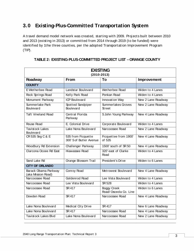
3.0 Existing-Plus-Committed Transportation System A travel demand model network was created, starting with 2009. Projects built between 2010 and 2013 (existing in 2013) or committed from 2014 through 2019 (to be funded) were identified by 1the three counties, per the adopted Transportation Improvement Program (TIP).
TABLE 2: EXISTING-PLUS-COMMITTED PROJECT LIST – ORANGE COUNTY
EXISTING (2010-2013)
Roadway From To Improvement COUNTY E Wetherbee Road Landstar Boulevard Wetherbee Road Widen to 4 Lanes Rock Springs Road Kelly Park Road Ponkan Road Widen to 4 Lanes
Monument Parkway ICP Boulevard Innovation Way New 2 Lane Roadway Summerlake Park Boulevard
Spotted Sandpiper Boulevard
Summerlakes Groves Street
New 2 Lane Roadway
Taft Vineland Road Central Florida Parkway
S John Young Parkway New 4 Lane Roadway
Rouse Road E. Colonial Drive Corporate Boulevard Widen to 4 Lanes Tavistock Lakes Boulevard
Lake Nona Boulevard Narcoossee Road New 2 Lane Roadway
CR 535 Seg C & E 535 from Ficquette 300' S of Butler Avenue
Ficquettee from 1900' of 535
New 4 Lane Roadway
Woodbury Rd Extension Challenger Parkway 1500' south of SR 50 New 4 Lane Roadway Clarcona Ocoee Rd East Hiawassee Road 320' east of Clarke
Road Widen to 4 Lanes
Sand Lake Rd Orange Blossom Trail President's Drive Widen to 6 Lanes
CITY OF ORLANDO
Barack Obama Parkway (aka Mission Road)
Conroy Road Metrowest Boulevard New 4 Lane Roadway
Narcoossee Road Goldenrod Road Lee Vista Boulevard Widen to 4 Lanes Narcoossee Road Lee Vista Boulevard SR 528 Widen to 4 Lanes
Narcoossee Road SR 417 Boggy Creek Road/Osceola Co. Line
Widen to 6 Lanes
Dowden Road SR 417 Narcoossee Road New 4 Lane Roadway
Lake Nona Boulevard Medical City Drive SR 417 New 6 Lane Roadway Lake Nona Boulevard SR 417 Narcoossee Road New 4 Lane Roadway Tavistock Lakes Blvd Lake Nona Boulevard Narcoossee Road New 2 Lane Roadway
4
2040 Long Range Transportation Plan: Technical Report 3
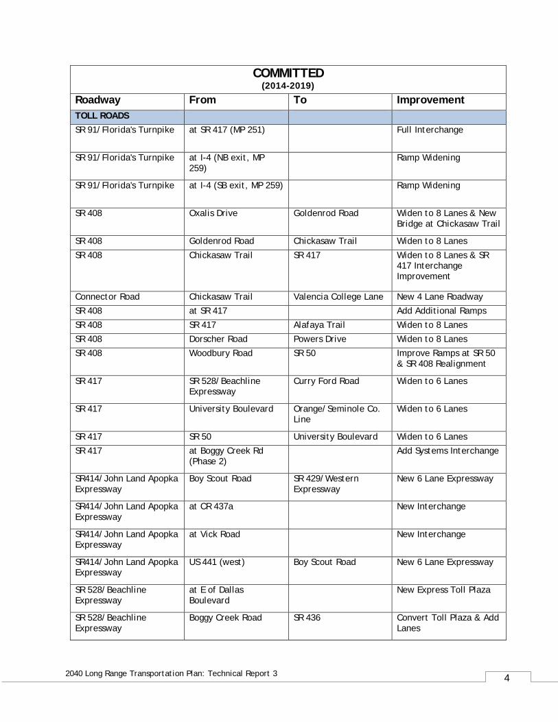
COMMITTED (2014-2019)
Roadway From To Improvement TOLL ROADS SR 91/Florida's Turnpike at SR 417 (MP 251) Full Interchange
SR 91/Florida's Turnpike at I-4 (NB exit, MP 259)
Ramp Widening
SR 91/Florida's Turnpike at I-4 (SB exit, MP 259) Ramp Widening
SR 408 Oxalis Drive Goldenrod Road Widen to 8 Lanes & New Bridge at Chickasaw Trail
SR 408 Goldenrod Road Chickasaw Trail Widen to 8 Lanes
SR 408 Chickasaw Trail SR 417 Widen to 8 Lanes & SR 417 Interchange Improvement
Connector Road Chickasaw Trail Valencia College Lane New 4 Lane Roadway SR 408 at SR 417 Add Additional Ramps SR 408 SR 417 Alafaya Trail Widen to 8 Lanes SR 408 Dorscher Road Powers Drive Widen to 8 Lanes SR 408 Woodbury Road SR 50 Improve Ramps at SR 50
& SR 408 Realignment
SR 417 SR 528/Beachline Expressway
Curry Ford Road Widen to 6 Lanes
SR 417 University Boulevard Orange/Seminole Co. Line
Widen to 6 Lanes
SR 417 SR 50 University Boulevard Widen to 6 Lanes SR 417 at Boggy Creek Rd
(Phase 2) Add Systems Interchange
SR414/John Land Apopka Expressway
Boy Scout Road SR 429/Western Expressway
New 6 Lane Expressway
SR414/John Land Apopka Expressway
at CR 437a New Interchange
SR414/John Land Apopka Expressway
at Vick Road New Interchange
SR414/John Land Apopka Expressway
US 441 (west) Boy Scout Road New 6 Lane Expressway
SR 528/Beachline Expressway
at E of Dallas Boulevard
New Express Toll Plaza
SR 528/Beachline Expressway
Boggy Creek Road SR 436 Convert Toll Plaza & Add Lanes
5
2040 Long Range Transportation Plan: Technical Report 3
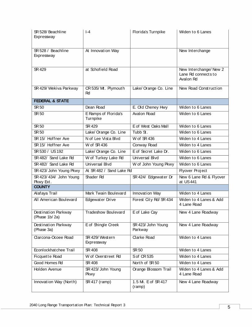
SR 528/Beachline Expressway
I-4 Florida's Turnpike Widen to 6 Lanes
SR 528 / Beachline Expressway
At Innovation Way New Interchange
SR 429 at Schofield Road New Interchange/New 2 Lane Rd connects to Avalon Rd
SR 429/Wekiva Parkway CR 535/Mt. Plymouth Rd
Lake/Orange Co. Line New Road Construction
FEDERAL & STATE SR 50 Dean Road E. Old Cheney Hwy Widen to 6 Lanes SR 50 E Ramps of Florida's
Turnpike Avalon Road Widen to 6 Lanes
SR 50 SR 429 E of West Oaks Mall Widen to 6 Lanes SR 50 Lake/Orange Co. Line Tubb St. Widen to 6 Lanes SR 15/ Hoffner Ave N of Lee Vista Blvd W of SR 436 Widen to 4 Lanes SR 15/ Hoffner Ave W of SR 436 Conway Road Widen to 4 Lanes
SR 530 / US 192 Lake/Orange Co. Line E of Secret Lake Dr. Widen to 6 Lanes SR 482/ Sand Lake Rd W of Turkey Lake Rd Universal Blvd Widen to 6 Lanes SR 482/ Sand Lake Rd Universal Blvd W of John Young Pkwy Widen to 6 Lanes SR 423/John Young Pkwy At SR 482 / Sand Lake Rd Flyover Project SR 423/434/ John Young Pkwy Ext.
Shader Rd SR 424/ Edgewater Dr New 6 Lane Rd & Flyover at US 441
COUNTY Alafaya Trail Mark Twain Boulevard Innovation Way Widen to 4 Lanes All American Boulevard Edgewater Drive Forest City Rd/SR 434 Widen to 4 Lanes & Add
4 Lane Road
Destination Parkway (Phase 1b/2a)
Tradeshow Boulevard E of Lake Cay New 4 Lane Roadway
Destination Parkway (Phase 3a)
E of Shingle Creek SR 423/John Young Parkway
New 4 Lane Roadway
Clarcona-Ocoee Road SR 429/Western Expressway
Clarke Road Widen to 4 Lanes
Econlockhatchee Trail SR 408 SR 50 Widen to 4 Lanes Ficquette Road W of Overstreet Rd S of CR 535 Widen to 4 Lanes Good Homes Rd SR 408 North of SR 50 Widen to 4 Lanes
Holden Avenue SR 423/John Young Pkwy
Orange Blossom Trail Widen to 4 Lanes & Add 4 Lane Road
Innovation Way (North) SR 417 (ramp) 1.5 Mi. E of SR 417 (ramp)
New 4 Lane Roadway
6
2040 Long Range Transportation Plan: Technical Report 3
Innovation Way (South) Moss Park Road OUC Railroad Coal Line
New 4 Lane Roadway
Innovation Way Over SR 528/Beachline Expressway
New 4 Lane Interchange w/ Ramps
International Drive S. Westwood Boulevard
N. Westwood Boulevard
Widen to 6 Lanes
John Young Parkway SR 528/Beachline Expressway
Florida's Turnpike/SR 91
Widen to 6 Lanes
Lake Underhill Road Goldenrod Road Chickasaw Trail Widen to 4 Lanes Rouse Road Lake Underhill Road SR 50 Widen to 4 Lanes
Wetherbee Road Balcombe Road Orange Avenue Widen to 4 Lanes & Lighting
Wildwood Avenue International Drive Palm Parkway New 4 Lane Roadway, Bridge, & Lighting
Wildwood Avenue Palm Parkway Apopka-Vineland Road New 4 Lane Roadway Winter Garden-Vineland Road
Magnolia Park Court SR 429 Widen to 4 Lanes & Lighting
Caneel Bay Boulevard Crosston Circle Orange/Osceola Co. Line
New 2 Lane Roadway
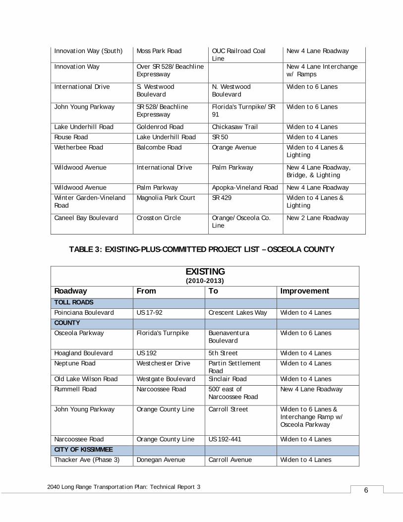
TABLE 3: EXISTING-PLUS-COMMITTED PROJECT LIST – OSCEOLA COUNTY
EXISTING (2010-2013)
Roadway From To Improvement TOLL ROADS
Poinciana Boulevard US 17-92 Crescent Lakes Way Widen to 4 Lanes COUNTY Osceola Parkway Florida's Turnpike Buenaventura
Boulevard Widen to 6 Lanes
Hoagland Boulevard US 192 5th Street Widen to 4 Lanes Neptune Road Westchester Drive Partin Settlement
Road Widen to 4 Lanes
Old Lake Wilson Road Westgate Boulevard Sinclair Road Widen to 4 Lanes Rummell Road Narcoossee Road 500' east of
Narcoossee Road New 4 Lane Roadway
John Young Parkway Orange County Line Carroll Street Widen to 6 Lanes & Interchange Ramp w/ Osceola Parkway
Narcoossee Road Orange County Line US 192-441 Widen to 4 Lanes
CITY OF KISSIMMEE Thacker Ave (Phase 3) Donegan Avenue Carroll Avenue Widen to 4 Lanes
7
2040 Long Range Transportation Plan: Technical Report 3
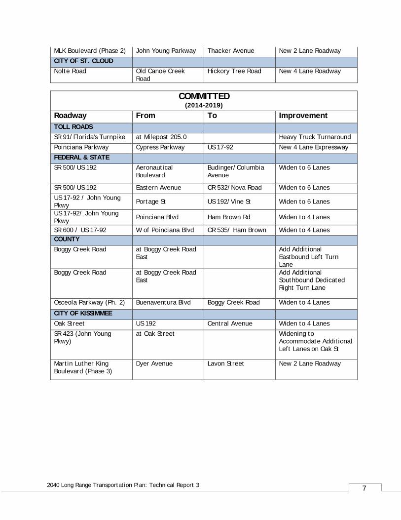
MLK Boulevard (Phase 2) John Young Parkway Thacker Avenue New 2 Lane Roadway CITY OF ST. CLOUD Nolte Road Old Canoe Creek
Road Hickory Tree Road New 4 Lane Roadway
COMMITTED (2014-2019)
Roadway From To Improvement TOLL ROADS SR 91/Florida's Turnpike at Milepost 205.0 Heavy Truck Turnaround
Poinciana Parkway Cypress Parkway US 17-92 New 4 Lane Expressway FEDERAL & STATE SR 500/US 192 Aeronautical
Boulevard Budinger/Columbia Avenue
Widen to 6 Lanes
SR 500/US 192 Eastern Avenue CR 532/Nova Road Widen to 6 Lanes US 17-92 / John Young Pkwy Portage St US 192/Vine St Widen to 6 Lanes
US 17-92/ John Young Pkwy Poinciana Blvd Ham Brown Rd Widen to 4 Lanes
SR 600 / US 17-92 W of Poinciana Blvd CR 535/ Ham Brown Widen to 4 Lanes COUNTY Boggy Creek Road at Boggy Creek Road
East Add Additional
Eastbound Left Turn Lane
Boggy Creek Road at Boggy Creek Road East
Add Additional Southbound Dedicated Right Turn Lane
Osceola Parkway (Ph. 2) Buenaventura Blvd Boggy Creek Road Widen to 4 Lanes
CITY OF KISSIMMEE
Oak Street US 192 Central Avenue Widen to 4 Lanes SR 423 (John Young Pkwy)
at Oak Street Widening to Accommodate Additional Left Lanes on Oak St
Martin Luther King Boulevard (Phase 3)
Dyer Avenue Lavon Street New 2 Lane Roadway
8
2040 Long Range Transportation Plan: Technical Report 3
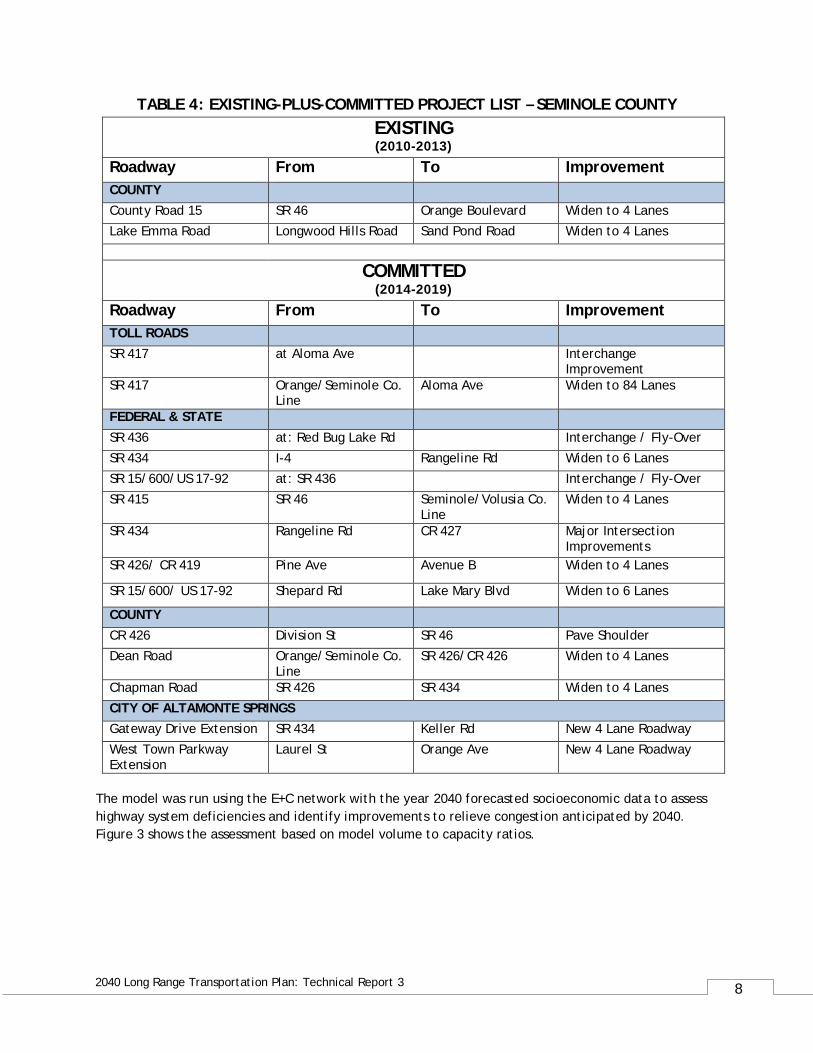
TABLE 4: EXISTING-PLUS-COMMITTED PROJECT LIST – SEMINOLE COUNTY EXISTING (2010-2013)
Roadway From To Improvement COUNTY County Road 15 SR 46 Orange Boulevard Widen to 4 Lanes Lake Emma Road Longwood Hills Road Sand Pond Road Widen to 4 Lanes
COMMITTED (2014-2019)
Roadway From To Improvement TOLL ROADS SR 417 at Aloma Ave Interchange
Improvement SR 417 Orange/Seminole Co.
Line Aloma Ave Widen to 84 Lanes
FEDERAL & STATE
SR 436 at: Red Bug Lake Rd Interchange / Fly-Over SR 434 I-4 Rangeline Rd Widen to 6 Lanes SR 15/600/US 17-92 at: SR 436 Interchange / Fly-Over SR 415 SR 46 Seminole/Volusia Co.
Line Widen to 4 Lanes
SR 434 Rangeline Rd CR 427 Major Intersection Improvements
SR 426/ CR 419 Pine Ave Avenue B Widen to 4 Lanes
SR 15/600/ US 17-92 Shepard Rd Lake Mary Blvd Widen to 6 Lanes
COUNTY CR 426 Division St SR 46 Pave Shoulder Dean Road Orange/Seminole Co.
Line SR 426/CR 426 Widen to 4 Lanes
Chapman Road SR 426 SR 434 Widen to 4 Lanes CITY OF ALTAMONTE SPRINGS Gateway Drive Extension SR 434 Keller Rd New 4 Lane Roadway West Town Parkway Extension
Laurel St Orange Ave New 4 Lane Roadway
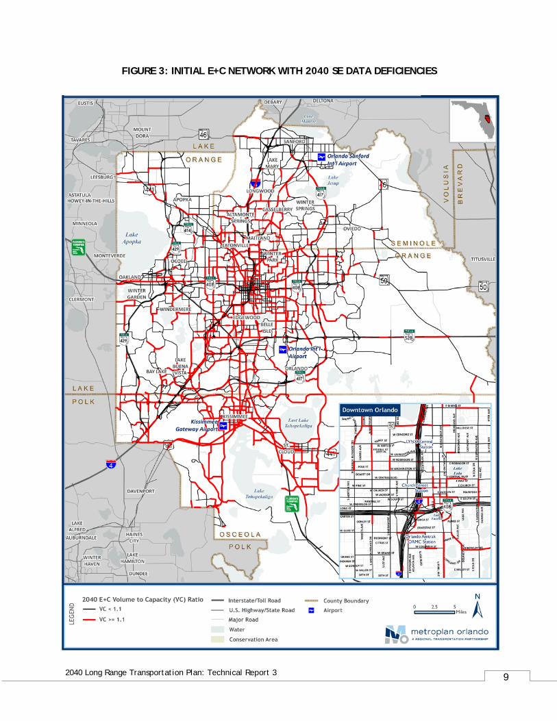
The model was run using the E+C network with the year 2040 forecasted socioeconomic data to assess highway system deficiencies and identify improvements to relieve congestion anticipated by 2040. Figure 3 shows the assessment based on model volume to capacity ratios.
9
2040 Long Range Transportation Plan: Technical Report 3
FIGURE 3: INITIAL E+C NETWORK WITH 2040 SE DATA DEFICIENCIES
10
2040 Long Range Transportation Plan: Technical Report 3
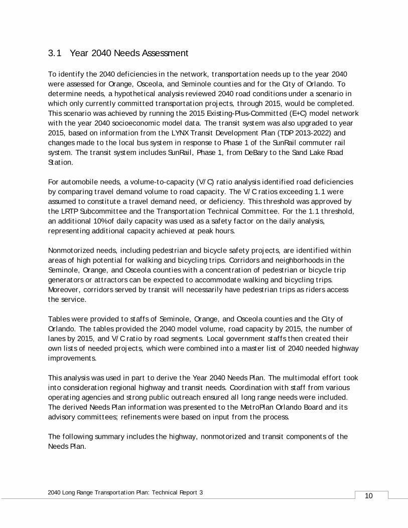
3.1 Year 2040 Needs Assessment To identify the 2040 deficiencies in the network, transportation needs up to the year 2040 were assessed for Orange, Osceola, and Seminole counties and for the City of Orlando. To determine needs, a hypothetical analysis reviewed 2040 road conditions under a scenario in which only currently committed transportation projects, through 2015, would be completed. This scenario was achieved by running the 2015 Existing-Plus-Committed (E+C) model network with the year 2040 socioeconomic model data. The transit system was also upgraded to year 2015, based on information from the LYNX Transit Development Plan (TDP 2013-2022) and changes made to the local bus system in response to Phase 1 of the SunRail commuter rail system. The transit system includes SunRail, Phase 1, from DeBary to the Sand Lake Road Station. For automobile needs, a volume-to-capacity (V/C) ratio analysis identified road deficiencies by comparing travel demand volume to road capacity. The V/C ratios exceeding 1.1 were assumed to constitute a travel demand need, or deficiency. This threshold was approved by the LRTP Subcommittee and the Transportation Technical Committee. For the 1.1 threshold, an additional 10% of daily capacity was used as a safety factor on the daily analysis, representing additional capacity achieved at peak hours. Nonmotorized needs, including pedestrian and bicycle safety projects, are identified within areas of high potential for walking and bicycling trips. Corridors and neighborhoods in the Seminole, Orange, and Osceola counties with a concentration of pedestrian or bicycle trip generators or attractors can be expected to accommodate walking and bicycling trips. Moreover, corridors served by transit will necessarily have pedestrian trips as riders access the service. Tables were provided to staffs of Seminole, Orange, and Osceola counties and the City of Orlando. The tables provided the 2040 model volume, road capacity by 2015, the number of lanes by 2015, and V/C ratio by road segments. Local government staffs then created their own lists of needed projects, which were combined into a master list of 2040 needed highway improvements. This analysis was used in part to derive the Year 2040 Needs Plan. The multimodal effort took into consideration regional highway and transit needs. Coordination with staff from various operating agencies and strong public outreach ensured all long range needs were included. The derived Needs Plan information was presented to the MetroPlan Orlando Board and its advisory committees; refinements were based on input from the process. The following summary includes the highway, nonmotorized and transit components of the Needs Plan.
11
2040 Long Range Transportation Plan: Technical Report 3
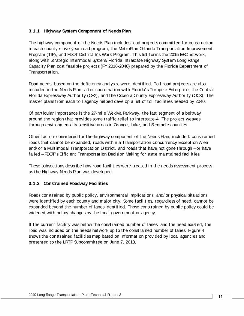
3.1.1 Highway System Component of Needs Plan The highway component of the Needs Plan includes road projects committed for construction in each county’s five-year road program, the MetroPlan Orlando Transportation Improvement Program (TIP), and FDOT District 5’s Work Program. This list forms the 2015 E+C network, along with Strategic Intermodal System/Florida Intrastate Highway System Long Range Capacity Plan cost feasible projects (FY 2016-2040) prepared by the Florida Department of Transportation. Road needs, based on the deficiency analysis, were identified. Toll road projects are also included in the Needs Plan, after coordination with Florida’s Turnpike Enterprise, the Central Florida Expressway Authority (CFX), and the Osceola County Expressway Authority (OCX). The master plans from each toll agency helped develop a list of toll facilities needed by 2040. Of particular importance is the 27-mile Wekiva Parkway, the last segment of a beltway around the region that provides some traffic relief to Interstate-4. The project weaves through environmentally sensitive areas in Orange, Lake, and Seminole counties. Other factors considered for the highway component of the Needs Plan, included: constrained roads that cannot be expanded, roads within a Transportation Concurrency Exception Area and/or a Multimodal Transportation District, and roads that have not gone through – or have failed – FDOT’s Efficient Transportation Decision Making for state maintained facilities. These subsections describe how road facilities were treated in the needs assessment process as the Highway Needs Plan was developed: 3.1.2 Constrained Roadway Facilities Roads constrained by public policy, environmental implications, and/or physical situations were identified by each county and major city. Some facilities, regardless of need, cannot be expanded beyond the number of lanes identified. Those constrained by public policy could be widened with policy changes by the local government or agency. If the current facility was below the constrained number of lanes, and the need existed, the road was included on the needs network up to the constrained number of lanes. Figure 4 shows the constrained facilities map based on information provided by local agencies and presented to the LRTP Subcommittee on June 7, 2013.
12
2040 Long Range Transportation Plan: Technical Report 3
FIGURE 4: CONSTRAINED FACILITIES BY NUMBER OF LANES
13
2040 Long Range Transportation Plan: Technical Report 3
3.1.3 Non-Motorized Component of Needs Plan The Sustainable Land Use Forecast, which was developed in coordination with partner jurisdictions, outlines the region’s land use plans and serves as a base for traffic and transit forecasts in the LRTP. It reflects the region’s vision for integrated multimodal transportation that supports transit-oriented development that takes full advantage of investments in SunRail commuter rail. As a part of the Sustainable Land Use Forecast, the LRTP outlines a 2040 Characterization Framework, which depicts the policies and visions of the member jurisdictions in an illustrative format. It depicts a development pattern with increased focused along transportation corridors, near employment centers and near transit stops, where it is most efficient to provide transportation, and at densities that allow for walking and cycling. These areas include:
• Primary Transit Shed • Secondary Transit Shed • Sustainable Development Corridor (locations where higher density, mixed use
development is more likely) • Areas of Special Interest (large amounts of developable land to be planned for
multimodal transportation options)
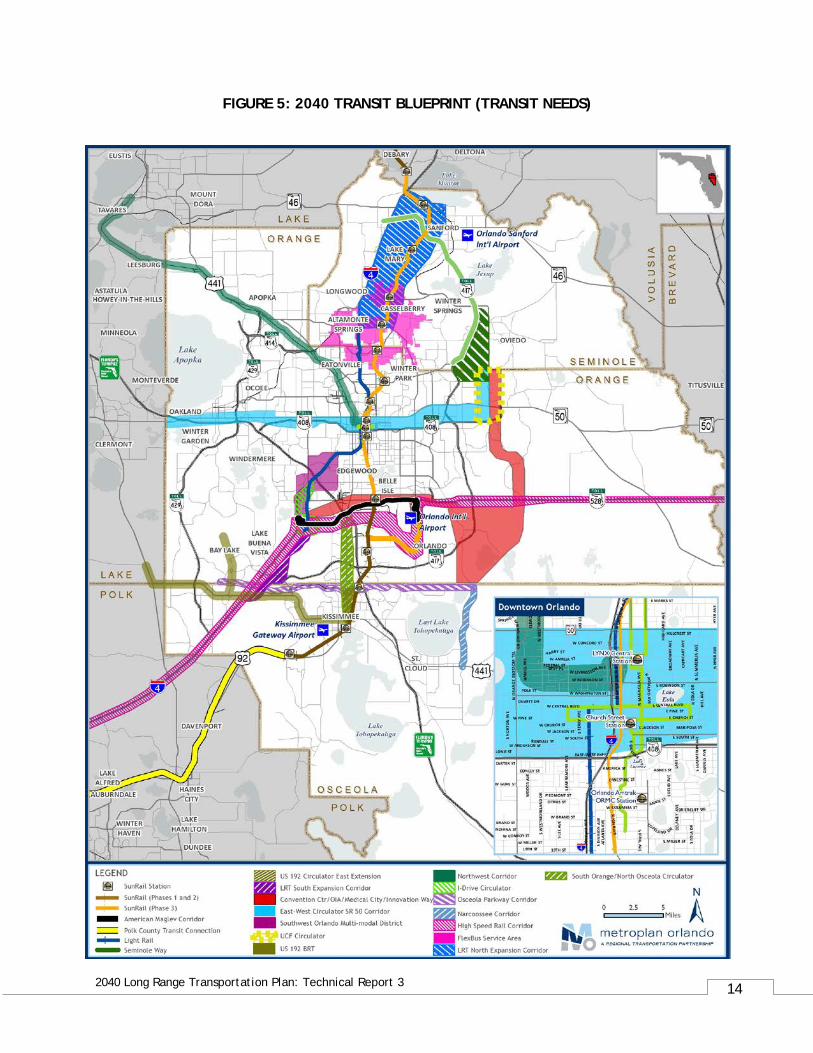
Transportation facilities in these areas are designated as needs for non-motorized transportation projects. 3.1.4 Transit System Component of Needs Plan The transit component of the 2040 Needs Plan is based on the region’s 2040 Transit Blueprint, initially adopted in the 2030 Long Range Transportation Plan as the Transit Vision Concept Plan. MetroPlan Orlando updated the Transit Vision Concept Plan during development of the 2040 Long Range Transportation Plan. Technical Report 5: Transit Element provides a summary of the transit blueprint for the region, independent of a horizon year. New and updated transit systems and respective corridors are also outlined. Figure 5 shows the 2040 Transit Blueprint, or transit needs, for the MetroPlan Orlando region.
14
2040 Long Range Transportation Plan: Technical Report 3
FIGURE 5: 2040 TRANSIT BLUEPRINT (TRANSIT NEEDS)
15
2040 Long Range Transportation Plan: Technical Report 3
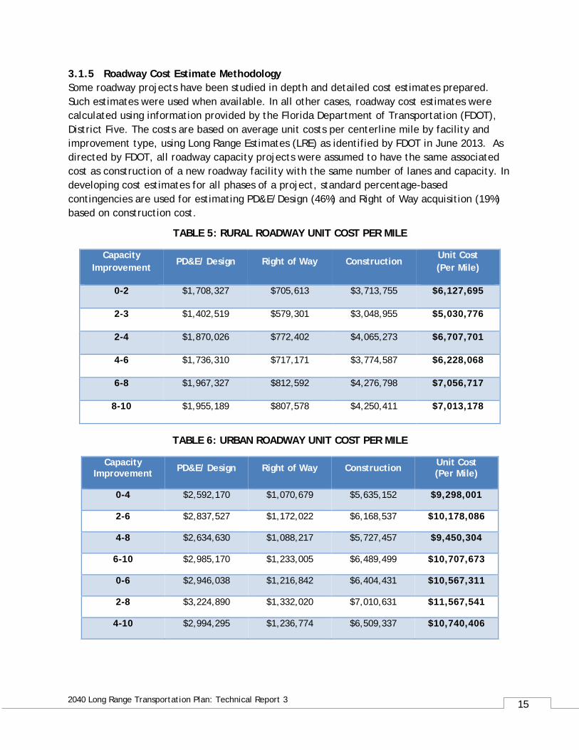
3.1.5 Roadway Cost Estimate Methodology Some roadway projects have been studied in depth and detailed cost estimates prepared. Such estimates were used when available. In all other cases, roadway cost estimates were calculated using information provided by the Florida Department of Transportation (FDOT), District Five. The costs are based on average unit costs per centerline mile by facility and improvement type, using Long Range Estimates (LRE) as identified by FDOT in June 2013. As directed by FDOT, all roadway capacity projects were assumed to have the same associated cost as construction of a new roadway facility with the same number of lanes and capacity. In developing cost estimates for all phases of a project, standard percentage-based contingencies are used for estimating PD&E/Design (46%) and Right of Way acquisition (19%) based on construction cost.
TABLE 5: RURAL ROADWAY UNIT COST PER MILE
Capacity Improvement
PD&E/ Design Right of Way Construction Unit Cost (Per Mile)
0-2 $1,708,327 $705,613 $3,713,755 $6,127,695
2-3 $1,402,519 $579,301 $3,048,955 $5,030,776
2-4 $1,870,026 $772,402 $4,065,273 $6,707,701
4-6 $1,736,310 $717,171 $3,774,587 $6,228,068
6-8 $1,967,327 $812,592 $4,276,798 $7,056,717
8-10 $1,955,189 $807,578 $4,250,411 $7,013,178
TABLE 6: URBAN ROADWAY UNIT COST PER MILE
Capacity Improvement PD&E/ Design Right of Way Construction Unit Cost
(Per Mile)
0-4 $2,592,170 $1,070,679 $5,635,152 $9,298,001
2-6 $2,837,527 $1,172,022 $6,168,537 $10,178,086
4-8 $2,634,630 $1,088,217 $5,727,457 $9,450,304
6-10 $2,985,170 $1,233,005 $6,489,499 $10,707,673
0-6 $2,946,038 $1,216,842 $6,404,431 $10,567,311
2-8 $3,224,890 $1,332,020 $7,010,631 $11,567,541
4-10 $2,994,295 $1,236,774 $6,509,337 $10,740,406
16
2040 Long Range Transportation Plan: Technical Report 3
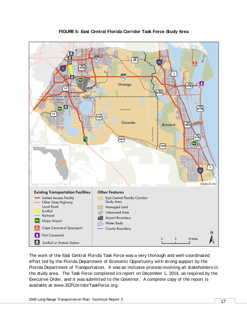
3.1.6 East Central Florida Corridors Task Force Recommendations The Florida Department of Transportation reinitiated its “New Corridors Program” in 2013 to take the lead with conducting visionary, long-term planning activities to meet the state’s future needs for moving both people and goods. This was to be done by transforming existing highways into multi-modal corridors and developing new multi-modal corridors where they were needed. The East Central Florida Corridor, part of the larger Tampa Bay-Central Florida Study Area, was chosen to be the first pilot study area in the “New Corridors Program.” Governor Rick Scott issued Executive Order 13-319 on November 11, 2013 establishing the East Central Florida Corridor Task Force. The Task Force was charged with developing recommendations for future transportation corridors to improve connectivity between established and emerging economic centers in portions of Brevard, Orange and Osceola Counties. A study area map is provided as figure 6. The study area includes a number of existing major activity centers. It also includes nearly 300,000 acres owned by two land owners, the Church of Latter Day Saints and the Viera Company. The North Ranch area, owned by the Church, is comprised of 250,000 acres. This is larger than all of Seminole County. Development of the area is not expected to begin until the year 2040 and build –out is expected by the year 2080. The population of the North Ranch area alone at build-out is expected to be about 500,000 people. A sector plan has been developed by Osceola County to shape the development that is expected to occur. Long-range planning done in a cooperative manner with landowners is an extraordinary opportunity to integrate transportation, land use and environmental planning such that outcomes are in keeping with the principles adopted through the “How Shall We Grow?” initiative. MetroPlan Orlando had two Board members serve on the Task Force – Orange County Commissioner Jennifer Thompson and Osceola County Commissioner Fred Hawkins, Jr. MetroPlan Orlando’s Executive Director served on the Task Force’s Technical Advisory Committee. The following is an excerpt from the Executive Order:
“The Orlando-Orange County Expressway Authority, the Osceola county Expressway Authority, MetroPlan Orlando, the Space Coast Transportation Planning Organization, the St. Johns River Water Management District, the East Central Florida Regional Planning Council, and other agencies, as appropriate, are encouraged to amend and revise their respective plans for future conservation, development and transportation, as the case may be, by September 30, 2015, to reflect and incorporate the recommendations of the Task Force and the long-term master plans prepared for adoption by the Local Governments.”
17
2040 Long Range Transportation Plan: Technical Report 3
FIGURE 6: East Central Florida Corridor Task Force Study Area
The work of the East Central Florida Task Force was a very thorough and well-coordinated effort led by the Florida Department of Economic Opportunity with strong support by the Florida Department of Transportation. It was an inclusive process involving all stakeholders in the study area. The Task Force completed its report on December 1, 2014, as required by the Executive Order, and it was submitted to the Governor. A complete copy of the report is available at www.ECFCorridorTaskForce.org.
18
2040 Long Range Transportation Plan: Technical Report 3
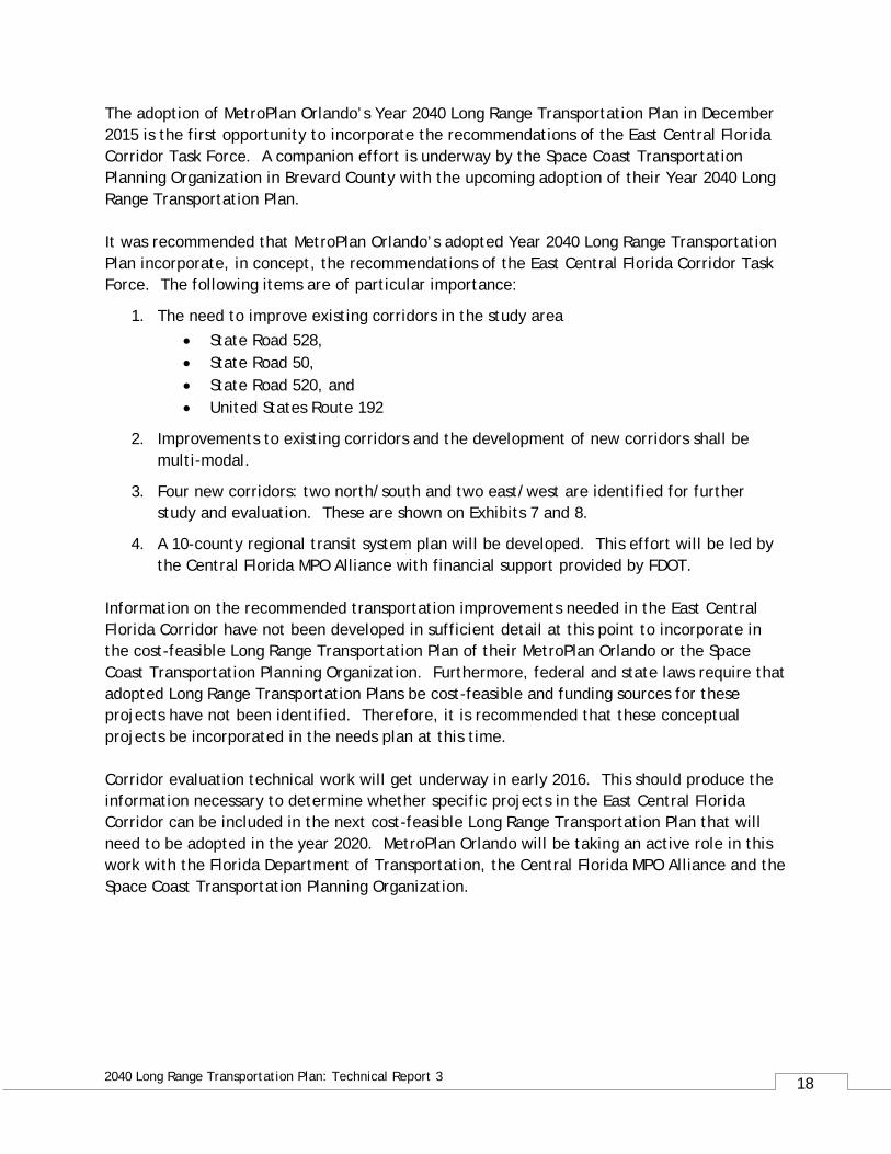
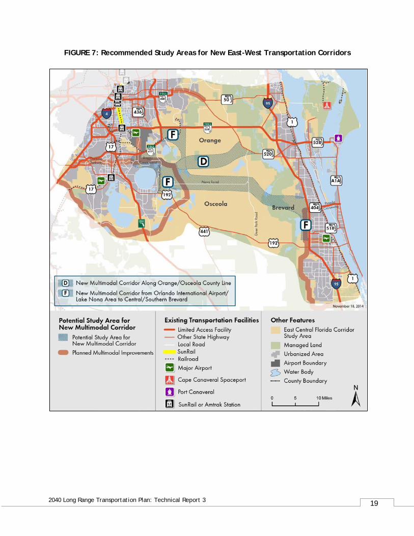
The adoption of MetroPlan Orlando’s Year 2040 Long Range Transportation Plan in December 2015 is the first opportunity to incorporate the recommendations of the East Central Florida Corridor Task Force. A companion effort is underway by the Space Coast Transportation Planning Organization in Brevard County with the upcoming adoption of their Year 2040 Long Range Transportation Plan. It was recommended that MetroPlan Orlando’s adopted Year 2040 Long Range Transportation Plan incorporate, in concept, the recommendations of the East Central Florida Corridor Task Force. The following items are of particular importance:
1. The need to improve existing corridors in the study area
• State Road 528, • State Road 50, • State Road 520, and • United States Route 192
2. Improvements to existing corridors and the development of new corridors shall be multi-modal.
3. Four new corridors: two north/south and two east/west are identified for further study and evaluation. These are shown on Exhibits 7 and 8.
4. A 10-county regional transit system plan will be developed. This effort will be led by the Central Florida MPO Alliance with financial support provided by FDOT.
Information on the recommended transportation improvements needed in the East Central Florida Corridor have not been developed in sufficient detail at this point to incorporate in the cost-feasible Long Range Transportation Plan of their MetroPlan Orlando or the Space Coast Transportation Planning Organization. Furthermore, federal and state laws require that adopted Long Range Transportation Plans be cost-feasible and funding sources for these projects have not been identified. Therefore, it is recommended that these conceptual projects be incorporated in the needs plan at this time. Corridor evaluation technical work will get underway in early 2016. This should produce the information necessary to determine whether specific projects in the East Central Florida Corridor can be included in the next cost-feasible Long Range Transportation Plan that will need to be adopted in the year 2020. MetroPlan Orlando will be taking an active role in this work with the Florida Department of Transportation, the Central Florida MPO Alliance and the Space Coast Transportation Planning Organization.
19
2040 Long Range Transportation Plan: Technical Report 3
FIGURE 7: Recommended Study Areas for New East-West Transportation Corridors
20
2040 Long Range Transportation Plan: Technical Report 3
FIGURE 8: Recommended Study Areas for New North-South Transportation Corridors
21
2040 Long Range Transportation Plan: Technical Report 3
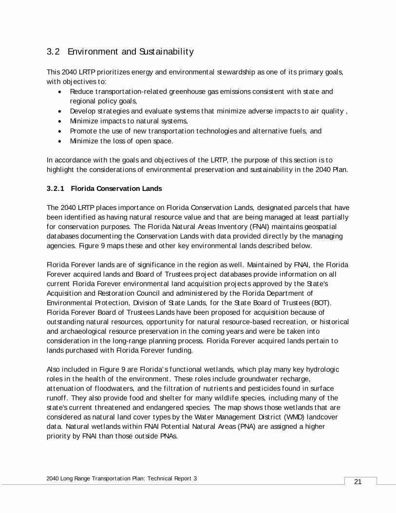
3.2 Environment and Sustainability This 2040 LRTP prioritizes energy and environmental stewardship as one of its primary goals, with objectives to:
• Reduce transportation-related greenhouse gas emissions consistent with state and regional policy goals,
• Develop strategies and evaluate systems that minimize adverse impacts to air quality , • Minimize impacts to natural systems, • Promote the use of new transportation technologies and alternative fuels, and • Minimize the loss of open space.
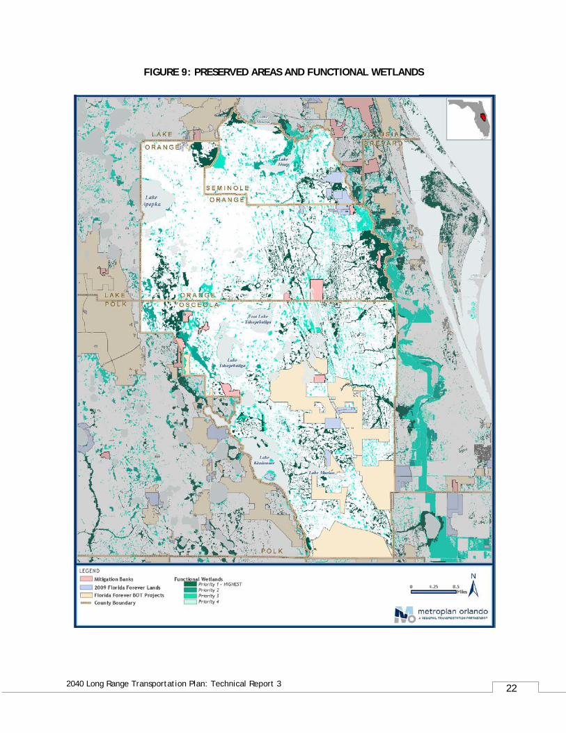
In accordance with the goals and objectives of the LRTP, the purpose of this section is to highlight the considerations of environmental preservation and sustainability in the 2040 Plan. 3.2.1 Florida Conservation Lands The 2040 LRTP places importance on Florida Conservation Lands, designated parcels that have been identified as having natural resource value and that are being managed at least partially for conservation purposes. The Florida Natural Areas Inventory (FNAI) maintains geospatial databases documenting the Conservation Lands with data provided directly by the managing agencies. Figure 9 maps these and other key environmental lands described below. Florida Forever lands are of significance in the region as well. Maintained by FNAI, the Florida Forever acquired lands and Board of Trustees project databases provide information on all current Florida Forever environmental land acquisition projects approved by the State's Acquisition and Restoration Council and administered by the Florida Department of Environmental Protection, Division of State Lands, for the State Board of Trustees (BOT). Florida Forever Board of Trustees Lands have been proposed for acquisition because of outstanding natural resources, opportunity for natural resource-based recreation, or historical and archaeological resource preservation in the coming years and were be taken into consideration in the long-range planning process. Florida Forever acquired lands pertain to lands purchased with Florida Forever funding. Also included in Figure 9 are Florida’s functional wetlands, which play many key hydrologic roles in the health of the environment. These roles include groundwater recharge, attenuation of floodwaters, and the filtration of nutrients and pesticides found in surface runoff. They also provide food and shelter for many wildlife species, including many of the state's current threatened and endangered species. The map shows those wetlands that are considered as natural land cover types by the Water Management District (WMD) landcover data. Natural wetlands within FNAI Potential Natural Areas (PNA) are assigned a higher priority by FNAI than those outside PNAs.
22
2040 Long Range Transportation Plan: Technical Report 3
FIGURE 9: PRESERVED AREAS AND FUNCTIONAL WETLANDS
23
2040 Long Range Transportation Plan: Technical Report 3
3.2.2 Mitigation Strategies Several strategies are available to MetroPlan to mitigate the environmental impacts of transportation projects in the region. The Florida Department of Transportation pursues wetland mitigation through regional, long range planning instead of conducting mitigation on a project by project basis. According to Section 373.4137, F.S. FDOT will fund and carry out the use of mitigation banks and other mitigation options that satisfy state and federal requirements. Local Water Management Districts prepare an annual inventory and Mitigation Plan. FDOT has agreements with the South Florida Water Management District and the St. Johns River Water Management District within the MetroPlan region. 3.2.3 Mitigation Banks Mitigation Banks are projects that enhance, restore, and/or preserve designated wetlands that serve to offset wetland impacts. The ecological benefits of mitigation projects are intended to compensate for the functional loss resulting from a permitted wetland impact. Florida Statute 373.4136, passed in 1996, provided the framework for permitting Mitigation Banks and established the FDOT Mitigation Program. Within Orange, Osceola, and Seminole counties reside 10 mitigation banks, shown in Figure 7. The largest of these are the TM Econ, Reedy Creek, and Southport Ranch mitigation banks. TM Econ Mitigation Bank The 5,199 acre TM-Econ Mitigation Bank provides a critical connection between the Orange County Split Oak Conservation Area and the Hal Scott Preserve in Eastern Orange County. This Bank embraces the headwaters of the Econlockhatchee River headwaters and is home to threatened and endangered species including the gopher tortoise and red-cockaded woodpecker nesting and foraging areas. The TM-Econ Mitigation Bank is also an integral part of the larger environmental corridor that extends from Lake Tohopeliga in Osceola County in the south to the St. Johns River headwaters of Lake Jessup and Lake Monroe to the north. The two most important goals of the restoration effort, removal of the man-made impacts and the restoration of natural hydro-periods were achieved by removing the historic impacts to an eight square mile area and by restoring past agricultural and industrial impacts. In addition, removal of access roads and the addition of miles of new drainage structures and ditch blocks have restored the natural hydro-period to this unique site. All construction and restoration has been completed and Conservation Easements have been placed over the entire 5,199 acre Bank Site. Additional information on this mitigation bank may be found online at http://www.tmeconmitigation.com/.
24
2040 Long Range Transportation Plan: Technical Report 3
Reedy Creek Mitigation Bank Reedy Creek Mitigation Bank (RCMB) is located in Polk and Osceola Counties, Florida, approximately ten (10) miles south of Kissimmee. The 3,520 acre bank has a service area that encompasses portions of Orange, Osceola, and Polk Counties. In addition to successful wetland restoration completed on the bank site, it also serves as a documented panther habitat. The bank is permitted by both the South Florida Water Management District and the U.S. Army Corps of Engineers and offers freshwater wetland credits for both herbaceous and forested impacts. Additional information may be found on the Reedy Creek Mitigation Bank website at http://www.mitigationmarketing.com/reedy_creek_mb.html. Southport Ranch Mitigation Bank Southport Ranch Mitigation Bank is located in the south-central portion of Osceola County, Florida. The 3,280 acre bank has a service area that encompasses portions of Orange, Osceola, and Polk Counties. The project site includes an extensive variety of habitat communities that are of regional significance, with its location adjacent to South Florida Water Management District lands, Disney Wilderness Preserve, Reedy Creek Swamp, and the Kissimmee Chain of Lakes. In addition, the majority of the site provides vital hydrologic recharge functions for the Florida Aquifer, Reedy Creek Swamp, and Kissimmee Chain of Lakes. Significant habitat within the project site is suitable for: the Florida black bear, crested caracara, bald eagle, red-cockaded woodpecker, Florida sandhill crane, and wood stork, as well as an extensive wading bird population, white-tailed deer, wild turkey, and other various mammals and reptiles. In addition, enhancement of the upland areas will provide habitat suitable for the gopher tortoise. Additional information on this mitigation bank may be found online at http://www.mitigationmarketing.com/southport_mb.html. 3.2.4 Federal and State Environmental Planning Provisions Environmental mitigation strategies are often developed for state- and federally-funded projects. MetroPlan Orlando is fully compliant with federal and state environmental planning provisions and project planning processes as part of this 2040 LRTP. 3.2.5 Federal Requirements The Safe, Accountable, Flexible, Efficient Transportation Equity Act: A Legacy for Users (SAFETEA-LU) and the Moving Ahead for Progress in the 21st Century Act (MAP-21) outlines federal requirements aimed at streamlining the environmental review process. This 2040 LRTP is consistent with these regulations outlined under SAFETEA-LU and MAP-21. Per regulation, the Federal Highway Administration (FHWA) requires that Long Range Transportation Plans include:
25
2040 Long Range Transportation Plan: Technical Report 3
• A discussion of potential environmental mitigation activities along with potential sites to carry out the activities to be included
• Representatives of users of pedestrian walkways, bicycle transportation facilities, and the disabled as parties to be provided with the opportunity to participate in the planning process
• A participation plan in consultation with interested parties that provides reasonable opportunities for all parties to comment
MetroPlan Orlando is required to consult with the State of Florida as well as the local agencies responsible for land use management, natural resources, environmental protection, conservation, and historic preservation concerning development of the LRTP. MetroPlan Orlando staff communicated with local government agencies responsible for land use management, natural resources, environmental protection, conservation, and historic preservation. MetroPlan staff also communicated with the Florida Department of Environmental Protection, and the Water Management Districts via email and phone during the months of August, September and November of 2015. During these communications, MetroPlan staff explained the LRTP process and requested the agencies to review and provide comment. Based on these consultations, no additional comments were received. The Federal Government additionally outlines air quality standards, including vehicle emissions-induced ozone thresholds, which the LRTP must include as part of the planning process. 3.2.6 State Requirements This 2040 LRTP additionally adheres to the Florida Department of Transportation (FDOT) MPO Program Management Handbook, which defines LRTP guidance for the safe and efficient management, operation, and development of a cost feasible intermodal transportation system. Under this guidance, LRTPs are required to address the development of surface transportation systems that will foster economic growth and development while minimizing transportation-related fuel consumption, air pollution and greenhouse gas emissions. FDOT advises that the plan should consider mitigation policies, strategies and activities derived from regional agency resource, conservation and mitigation plans, as available. This mitigation discussion should address a broad range of natural resources including wetlands, water resources, and protected species, in addition to impacts to the human environment. 3.2.7 Efficient Transportation Decision Making The Florida Department of Transportation’s Efficient Transportation Decision Making (ETDM) process was introduced into the MPO Long Range Transportation Plan for the first time in the 2025 Plan. ETDM provides resource agencies and the public with access to project plans and information about a project’s potential impact on Florida’s resources.
26
2040 Long Range Transportation Plan: Technical Report 3
ETDM includes early agency and community involvement during the MPO plan development. The Environmental Screening Tool (EST) ensures interaction between resource agencies and planners. MetroPlan Orlando worked with FDOT District 5 to identify new state facilities that required screening through this ETDM tool. The Highway Needs Plan network was finalized after coordinating with multiple agencies and gathering input from the MetroPlan Orlando Board, advisory committees, and subcommittees.
3.3 Financial Forecasts The currently committed and reasonably available funding levels are the foundation for the financials used in developing the Cost Feasible Plan detailed later in this report. These revenue forecasts were used to pare down the needed project list to a cost feasible list for 2040 and interim years 2020, 2025, and 2030. The list was based on year-of-expenditure (YOE) estimates for project costs and available funds for the same interim year. The adopted 2040 Long Range Transportation Plan adheres to the metropolitan planning rule from the U.S. Department of Transportation, which states:
The Plan shall include a financial plan that demonstrates the consistency of proposed transportation investments with already available and projected sources of revenue.
For additional information regarding the development of the revenue forecasts, refer to Technical Report 2: Financial Resources. Revenue forecasts are provided for federal, state, and county resources for road and transit components. Projected funds for each source (and for each county) are covered in Appendix B of that technical report.
4.0 Year 2040 Cost Feasible Highway Network Development Because of limited financial resources, some transportation needs cannot be funded. The list of needed projects was compared to revenue available for highway capacity improvements. The highway component of the Cost Feasible Plan includes all road projects committed for construction within each county’s Five Year Road Program and the MPO’s Transportation Improvement Program (TIP). In addition, all the Strategic Intermodal System (SIS)/Florida Intrastate Highway System (FIHS) Long Range Capacity Plan (Fiscal Years 2019-2040) projects prepared by the Florida Department of Transportation are included. Federal, state, county, and local projects were also defined for the Cost Feasible Plan, based on prioritization coordinated through local government staff. Budget allocation spreadsheets were developed for the different categories, including: SIS facilities funded by FDOT/FHWA; MPO Priority Projects funded by MPO using FDOT Non-SIS funds and TMA funds; Orange County funded projects that include City of Orlando; Osceola County funded projects that include City of Kissimmee and St. Cloud; and Seminole County
27
2040 Long Range Transportation Plan: Technical Report 3
funded projects that include local municipalities. Toll facilities were assumed to be paid by toll revenues. Simplified tables of the cost feasible project list are presented in Tables 5 through10 and the full budget allocation tables are included in the appendix of this report. A technical analysis followed to determine if implementing the key transportation projects would fulfill the region’s vision. As detailed in Technical Report 2, a projection of financial resources determined the region’s ability to fund the most critical transportation improvement needs by five-year increments (2020, 2025, 2030, and 2040). The major assumption is that each project is completed within the five-year increments. A project cost was developed for each improvement using year 2013 as the base and coordinated with each of the local agencies. For SIS facilities, the costs were provided by FDOT. A cost was estimated for the year 2013 using the FDOT-provided inflation factors to have a common base for all categories. The improvements identified in Tables 7 through 11 and shown in Figure 10 were used for cost estimating purposes only; the actual solutions will be determined during the project development phase of each project. All project needs - after removing those deemed constrained and/or in exception areas or transportation districts (see Figure 4) - were prioritized. Different methodologies were used by each county to complete the ranking. Projects were then separated into three categories, based on the funding source eligibility: SIS, priority, and county. SIS projects were based on the Cost Feasible Plan from FDOT. The MetroPlan Orlando priority projects include those deemed affordable, based on the available revenues by plan year. The county project list was pared down until anticipated revenues were exhausted. The cost feasible toll facilities list was developed using the master plans from Florida’s Turnpike Enterprise, Central Florida Expressway Authority (formerly OOCEA), and the Osceola County Expressway Authority(OCX) and information gathered from each of the agencies to allocate projects into the anticipated years. Based on projections, Orange County was able to fund 37 of 152 county projects. Osceola County was able to fund all 116 county project needs, plus 13 federal/state projects. Seminole County was able to fund 22 of the 23 highway projects. Figure 10 provides the highway system component of the 2040 Cost Feasible Plan. Lists of the adopted plan SIS, federal/state, county/city, and expressway/toll road projects are presented in the following pages. Detailed project financial and priority information can be found in Appendix A: Budget Allocation.
28
2040 Long Range Transportation Plan: Technical Report 3
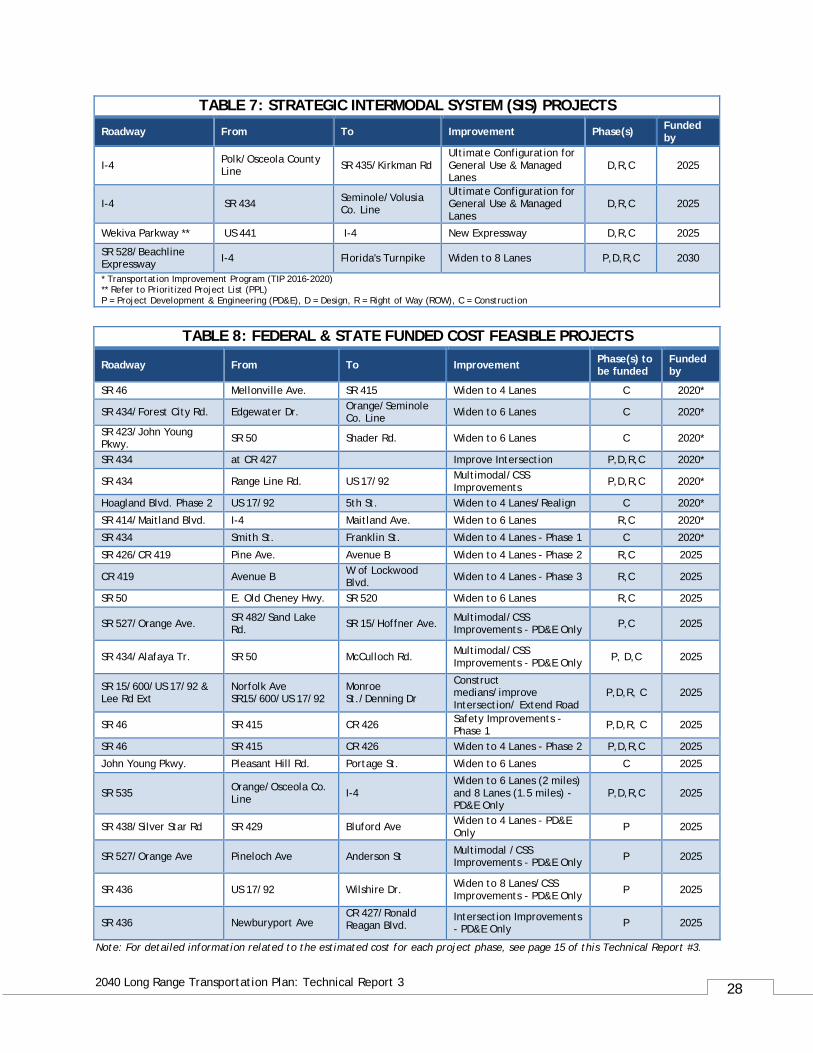
TABLE 7: STRATEGIC INTERMODAL SYSTEM (SIS) PROJECTS
Roadway From To Improvement Phase(s) Funded by
I-4 Polk/Osceola County Line SR 435/Kirkman Rd
Ultimate Configuration for General Use & Managed Lanes
D,R,C 2025
I-4 SR 434 Seminole/Volusia Co. Line
Ultimate Configuration for General Use & Managed Lanes
D,R,C 2025
Wekiva Parkway ** US 441 I-4 New Expressway D,R,C 2025
SR 528/Beachline Expressway I-4 Florida's Turnpike Widen to 8 Lanes P,D,R,C 2030
* Transportation Improvement Program (TIP 2016-2020) ** Refer to Prioritized Project List (PPL) P = Project Development & Engineering (PD&E), D = Design, R = Right of Way (ROW), C = Construction
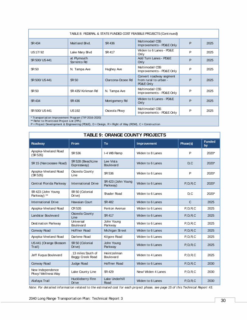
TABLE 8: FEDERAL & STATE FUNDED COST FEASIBLE PROJECTS
Roadway From To Improvement Phase(s) to be funded
Funded by
SR 46 Mellonville Ave. SR 415 Widen to 4 Lanes C 2020*
SR 434/Forest City Rd. Edgewater Dr. Orange/Seminole Co. Line Widen to 6 Lanes C 2020*
SR 423/John Young Pkwy. SR 50 Shader Rd. Widen to 6 Lanes C 2020*
SR 434 at CR 427 Improve Intersection P,D,R,C 2020*
SR 434 Range Line Rd. US 17/92 Multimodal/CSS Improvements P,D,R,C 2020*
Hoagland Blvd. Phase 2 US 17/92 5th St. Widen to 4 Lanes/Realign C 2020*
SR 414/Maitland Blvd. I-4 Maitland Ave. Widen to 6 Lanes R,C 2020*
SR 434 Smith St. Franklin St. Widen to 4 Lanes - Phase 1 C 2020*
SR 426/CR 419 Pine Ave. Avenue B Widen to 4 Lanes - Phase 2 R,C 2025
CR 419 Avenue B W of Lockwood Blvd. Widen to 4 Lanes - Phase 3 R,C 2025
SR 50 E. Old Cheney Hwy. SR 520 Widen to 6 Lanes R,C 2025
SR 527/Orange Ave. SR 482/Sand Lake Rd. SR 15/Hoffner Ave. Multimodal/CSS
Improvements - PD&E Only P,C 2025
SR 434/Alafaya Tr. SR 50 McCulloch Rd. Multimodal/CSS Improvements - PD&E Only P, D,C 2025
SR 15/600/US 17/92 & Lee Rd Ext
Norfolk Ave SR15/600/US 17/92
Monroe St./Denning Dr
Construct medians/improve Intersection/ Extend Road
P,D,R, C 2025
SR 46 SR 415 CR 426 Safety Improvements - Phase 1 P,D,R, C 2025
SR 46 SR 415 CR 426 Widen to 4 Lanes - Phase 2 P,D,R,C 2025
John Young Pkwy. Pleasant Hill Rd. Portage St. Widen to 6 Lanes C 2025
SR 535 Orange/Osceola Co. Line I-4
Widen to 6 Lanes (2 miles) and 8 Lanes (1.5 miles) - PD&E Only
P,D,R,C 2025
SR 438/Silver Star Rd SR 429 Bluford Ave Widen to 4 Lanes - PD&E Only P 2025
SR 527/Orange Ave Pineloch Ave Anderson St Multimodal /CSS Improvements - PD&E Only P 2025
SR 436 US 17/92 Wilshire Dr. Widen to 8 Lanes/CSS Improvements - PD&E Only P 2025
SR 436 Newburyport Ave CR 427/Ronald Reagan Blvd.
Intersection Improvements - PD&E Only P 2025
Note: For detailed information related to the estimated cost for each project phase, see page 15 of this Technical Report #3.
29
2040 Long Range Transportation Plan: Technical Report 3
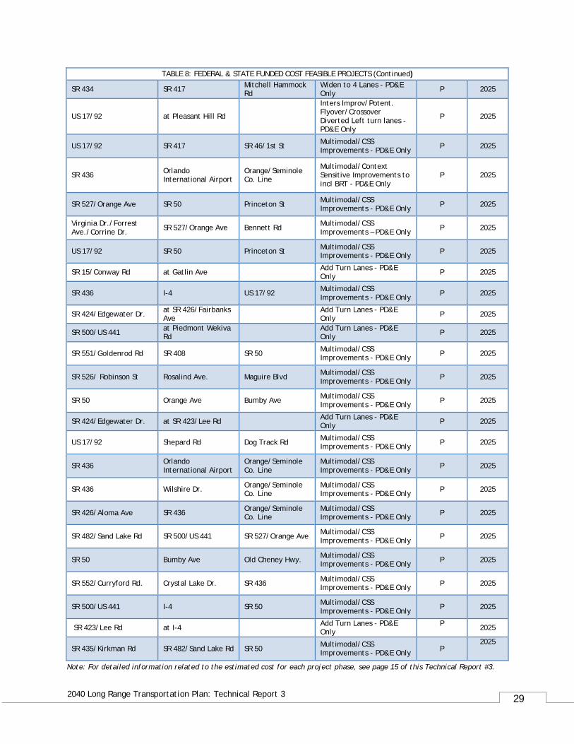
TABLE 8: FEDERAL & STATE FUNDED COST FEASIBLE PROJECTS (Continued)
SR 434 SR 417 Mitchell Hammock Rd
Widen to 4 Lanes - PD&E Only P 2025
US 17/92 at Pleasant Hill Rd
Inters Improv/Potent. Flyover/Crossover Diverted Left turn lanes - PD&E Only
P 2025
US 17/92 SR 417 SR 46/1st St Multimodal/CSS Improvements - PD&E Only P 2025
SR 436 Orlando International Airport
Orange/Seminole Co. Line
Multimodal/Context Sensitive Improvements to incl BRT - PD&E Only
P 2025
SR 527/Orange Ave SR 50 Princeton St Multimodal/CSS Improvements - PD&E Only P 2025
Virginia Dr./Forrest Ave./Corrine Dr. SR 527/Orange Ave Bennett Rd Multimodal/CSS
Improvements – PD&E Only P 2025
US 17/92 SR 50 Princeton St Multimodal/CSS Improvements - PD&E Only P 2025
SR 15/Conway Rd at Gatlin Ave Add Turn Lanes - PD&E Only P 2025
SR 436 I-4 US 17/92 Multimodal/CSS Improvements - PD&E Only P 2025
SR 424/Edgewater Dr. at SR 426/Fairbanks Ave Add Turn Lanes - PD&E
Only P 2025
SR 500/US 441 at Piedmont Wekiva Rd Add Turn Lanes - PD&E
Only P 2025
SR 551/Goldenrod Rd SR 408 SR 50 Multimodal/CSS Improvements - PD&E Only P 2025
SR 526/ Robinson St Rosalind Ave. Maguire Blvd Multimodal/CSS Improvements - PD&E Only P 2025
SR 50 Orange Ave Bumby Ave Multimodal/CSS Improvements - PD&E Only P 2025
SR 424/Edgewater Dr. at SR 423/Lee Rd Add Turn Lanes - PD&E Only P 2025
US 17/92 Shepard Rd Dog Track Rd Multimodal/CSS Improvements - PD&E Only P 2025
SR 436 Orlando International Airport
Orange/Seminole Co. Line
Multimodal/CSS Improvements - PD&E Only P 2025
SR 436 Wilshire Dr. Orange/Seminole Co. Line
Multimodal/CSS Improvements - PD&E Only P 2025
SR 426/Aloma Ave SR 436 Orange/Seminole Co. Line
Multimodal/CSS Improvements - PD&E Only P 2025
SR 482/Sand Lake Rd SR 500/US 441 SR 527/Orange Ave Multimodal/CSS Improvements - PD&E Only P 2025
SR 50 Bumby Ave Old Cheney Hwy. Multimodal/CSS Improvements - PD&E Only P 2025
SR 552/Curryford Rd. Crystal Lake Dr. SR 436 Multimodal/CSS Improvements - PD&E Only P 2025
SR 500/US 441 I-4 SR 50 Multimodal/CSS Improvements - PD&E Only P 2025
SR 423/Lee Rd at I-4 Add Turn Lanes - PD&E Only
P 2025
SR 435/Kirkman Rd SR 482/Sand Lake Rd SR 50 Multimodal/CSS Improvements - PD&E Only P
2025
Note: For detailed information related to the estimated cost for each project phase, see page 15 of this Technical Report #3.
30
2040 Long Range Transportation Plan: Technical Report 3
TABLE 8: FEDERAL & STATE FUNDED COST FEASIBLE PROJECTS (Continued)
SR 434 Maitland Blvd. SR 436 Multimodal/CSS Improvements - PD&E Only P 2025
US 17/92 Lake Mary Blvd SR 417 Widen to 6 Lanes - PD&E Only P 2025
SR 500/US 441 at Plymouth Sorrento Rd Add Turn Lanes - PD&E
Only P 2025
SR 50 N. Tampa Ave Hughey Ave Multimodal/CSS Improvements - PD&E Only P 2025
SR 500/US 441 SR 50 Clarcona-Ocoee Rd Convert roadway segment from rural to urban - PD&E Only
P 2025
SR 50 SR 435/Kirkman Rd N. Tampa Ave Multimodal/CSS Improvements - PD&E Only P 2025
SR 434 SR 436 Montgomery Rd Widen to 6 Lanes - PD&E Only P 2025
SR 500/US 441 US 192 Osceola Pkwy Multimodal/CSS Improvements - PD&E Only P 2025
* Transportation Improvement Program (TIP 2016-2020) ** Refer to Prioritized Project List (PPL) P = Project Development & Engineering (PD&E), D = Design, R = Right of Way (ROW), C = Construction
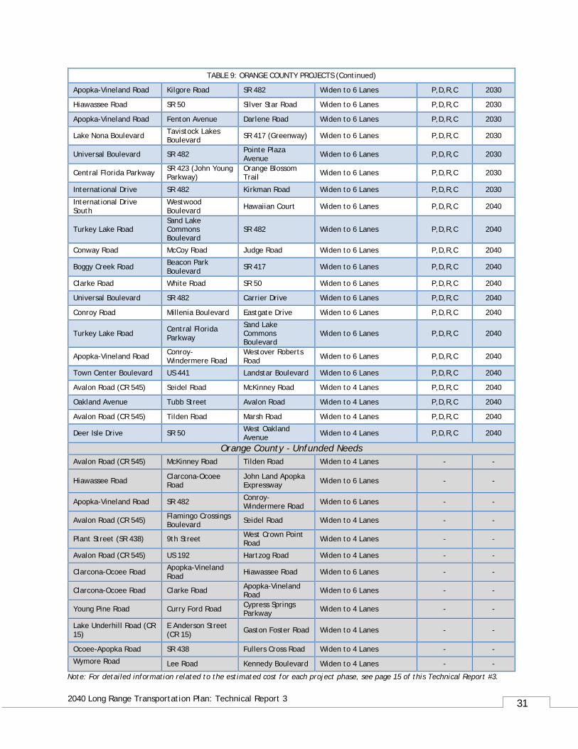
TABLE 9: ORANGE COUNTY PROJECTS
Roadway From To Improvement Phase(s) Funded by
Apopka-Vineland Road (SR 535) SR 536 I-4 WB Ramp Widen to 8 Lanes P 2020*
SR 15 (Narcoossee Road) SR 528 (BeachLine Expressway)
Lee Vista Boulevard Widen to 6 Lanes D,C 2020*
Apopka-Vineland Road (SR 535)
Osceola County Line SR 536 Widen to 6 Lanes P 2020*
Central Florida Parkway International Drive SR 423 (John Young Parkway) Widen to 6 Lanes P,D,R,C 2020*
SR 423 (John Young Parkway) **
SR 50 (Colonial Drive) Shader Road Widen to 6 Lanes D,C 2020*
International Drive Hawaian Court SR 482 Widen to 6 Lanes C 2025
Apopka-Vineland Road CR 535 Fenton Avenue Widen to 6 Lanes P,D,R,C 2025
Landstar Boulevard Osceola County Line SR 417 Widen to 6 Lanes P,D,R,C 2025
Destination Parkway Universal Boulevard
John Young Parkway Widen to 6 Lanes P,D,R,C 2025
Conway Road Hoffner Road Michigan Street Widen to 6 Lanes P,D,R,C 2025
Apopka-Vineland Road Darlene Road Kilgore Road Widen to 6 Lanes P,D,R,C 2025
US 441 (Orange Blossom Trail)
SR 50 (Colonial Drive)
John Young Parkway Widen to 6 Lanes P,D,R,C 2025
Jeff Fuqua Boulevard .13 miles South of Boggy Creek Road
Heintzelman Boulevard Widen to 4 Lanes P,D,R,C 2025
Conway Road Judge Road Hoffner Road Widen to 6 Lanes P,D,R,C 2030
New Independence Pkwy/Wellness Way Lake County Line SR 429 New/Widen 4 Lanes P,D,R,C 2030
Alafaya Trail Huckleberry Finn Drive
Lake Underhill Road Widen to 6 Lanes P,D,R,C 2030
Note: For detailed information related to the estimated cost for each project phase, see page 15 of this Technical Report #3.
31
2040 Long Range Transportation Plan: Technical Report 3
TABLE 9: ORANGE COUNTY PROJECTS (Continued)
Apopka-Vineland Road Kilgore Road SR 482 Widen to 6 Lanes P,D,R,C 2030
Hiawassee Road SR 50 Silver Star Road Widen to 6 Lanes P,D,R,C 2030
Apopka-Vineland Road Fenton Avenue Darlene Road Widen to 6 Lanes P,D,R,C 2030
Lake Nona Boulevard Tavistock Lakes Boulevard SR 417 (Greenway) Widen to 6 Lanes P,D,R,C 2030
Universal Boulevard SR 482 Pointe Plaza Avenue Widen to 6 Lanes P,D,R,C 2030
Central Florida Parkway SR 423 (John Young Parkway)
Orange Blossom Trail Widen to 6 Lanes P,D,R,C 2030
International Drive SR 482 Kirkman Road Widen to 6 Lanes P,D,R,C 2030
International Drive South
Westwood Boulevard Hawaiian Court Widen to 6 Lanes P,D,R,C 2040
Turkey Lake Road Sand Lake Commons Boulevard
SR 482 Widen to 6 Lanes P,D,R,C 2040
Conway Road McCoy Road Judge Road Widen to 6 Lanes P,D,R,C 2040
Boggy Creek Road Beacon Park Boulevard SR 417 Widen to 6 Lanes P,D,R,C 2040
Clarke Road White Road SR 50 Widen to 6 Lanes P,D,R,C 2040
Universal Boulevard SR 482 Carrier Drive Widen to 6 Lanes P,D,R,C 2040
Conroy Road Millenia Boulevard Eastgate Drive Widen to 6 Lanes P,D,R,C 2040
Turkey Lake Road Central Florida Parkway
Sand Lake Commons Boulevard
Widen to 6 Lanes P,D,R,C 2040
Apopka-Vineland Road Conroy-Windermere Road
Westover Roberts Road Widen to 6 Lanes P,D,R,C 2040
Town Center Boulevard US 441 Landstar Boulevard Widen to 6 Lanes P,D,R,C 2040
Avalon Road (CR 545) Seidel Road McKinney Road Widen to 4 Lanes P,D,R,C 2040
Oakland Avenue Tubb Street Avalon Road Widen to 4 Lanes P,D,R,C 2040
Avalon Road (CR 545) Tilden Road Marsh Road Widen to 4 Lanes P,D,R,C 2040
Deer Isle Drive SR 50 West Oakland Avenue Widen to 4 Lanes P,D,R,C 2040
Orange County - Unfunded Needs Avalon Road (CR 545) McKinney Road Tilden Road Widen to 4 Lanes - -
Hiawassee Road Clarcona-Ocoee Road
John Land Apopka Expressway Widen to 6 Lanes - -
Apopka-Vineland Road SR 482 Conroy-Windermere Road Widen to 6 Lanes - -
Avalon Road (CR 545) Flamingo Crossings Boulevard Seidel Road Widen to 4 Lanes - -
Plant Street (SR 438) 9th Street West Crown Point Road Widen to 4 Lanes - -
Avalon Road (CR 545) US 192 Hartzog Road Widen to 4 Lanes - -
Clarcona-Ocoee Road Apopka-Vineland Road Hiawassee Road Widen to 6 Lanes - -
Clarcona-Ocoee Road Clarke Road Apopka-Vineland Road Widen to 6 Lanes - -
Young Pine Road Curry Ford Road Cypress Springs Parkway Widen to 4 Lanes - -
Lake Underhill Road (CR 15)
E Anderson Street (CR 15) Gaston Foster Road Widen to 4 Lanes - -
Ocoee-Apopka Road SR 438 Fullers Cross Road Widen to 4 Lanes - -
Wymore Road Lee Road Kennedy Boulevard Widen to 4 Lanes - -
Note: For detailed information related to the estimated cost for each project phase, see page 15 of this Technical Report #3.
32
2040 Long Range Transportation Plan: Technical Report 3
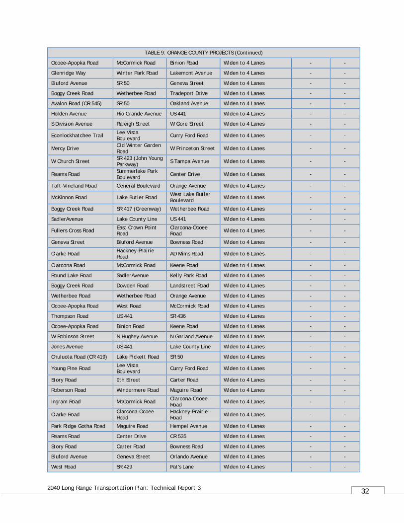
TABLE 9: ORANGE COUNTY PROJECTS (Continued)
Ocoee-Apopka Road McCormick Road Binion Road Widen to 4 Lanes - -
Glenridge Way Winter Park Road Lakemont Avenue Widen to 4 Lanes - -
Bluford Avenue SR 50 Geneva Street Widen to 4 Lanes - -
Boggy Creek Road Wetherbee Road Tradeport Drive Widen to 4 Lanes - -
Avalon Road (CR 545) SR 50 Oakland Avenue Widen to 4 Lanes - -
Holden Avenue Rio Grande Avenue US 441 Widen to 4 Lanes - -
S Division Avenue Raleigh Street W Gore Street Widen to 4 Lanes - -
Econlockhatchee Trail Lee Vista Boulevard Curry Ford Road Widen to 4 Lanes - -
Mercy Drive Old Winter Garden Road W Princeton Street Widen to 4 Lanes - -
W Church Street SR 423 (John Young Parkway) S Tampa Avenue Widen to 4 Lanes - -
Reams Road Summerlake Park Boulevard Center Drive Widen to 4 Lanes - -
Taft-Vineland Road General Boulevard Orange Avenue Widen to 4 Lanes - -
McKinnon Road Lake Butler Road West Lake Butler Boulevard Widen to 4 Lanes - -
Boggy Creek Road SR 417 (Greenway) Wetherbee Road Widen to 4 Lanes - -
SadlerAvenue Lake County Line US 441 Widen to 4 Lanes - -
Fullers Cross Road East Crown Point Road
Clarcona-Ocoee Road Widen to 4 Lanes - -
Geneva Street Bluford Avenue Bowness Road Widen to 4 Lanes - -
Clarke Road Hackney-Prairie Road AD Mims Road Widen to 6 Lanes - -
Clarcona Road McCormick Road Keene Road Widen to 4 Lanes - -
Round Lake Road SadlerAvenue Kelly Park Road Widen to 4 Lanes - -
Boggy Creek Road Dowden Road Landstreet Road Widen to 4 Lanes - -
Wetherbee Road Wetherbee Road Orange Avenue Widen to 4 Lanes - -
Ocoee-Apopka Road West Road McCormick Road Widen to 4 Lanes - -
Thompson Road US 441 SR 436 Widen to 4 Lanes - -
Ocoee-Apopka Road Binion Road Keene Road Widen to 4 Lanes - -
W Robinson Street N Hughey Avenue N Garland Avenue Widen to 4 Lanes - -
Jones Avenue US 441 Lake County Line Widen to 4 Lanes - -
Chuluota Road (CR 419) Lake Pickett Road SR 50 Widen to 4 Lanes - -
Young Pine Road Lee Vista Boulevard Curry Ford Road Widen to 4 Lanes - -
Story Road 9th Street Carter Road Widen to 4 Lanes - -
Roberson Road Windermere Road Maguire Road Widen to 4 Lanes - -
Ingram Road McCormick Road Clarcona-Ocoee Road Widen to 4 Lanes - -
Clarke Road Clarcona-Ocoee Road
Hackney-Prairie Road Widen to 4 Lanes - -
Park Ridge Gotha Road Maguire Road Hempel Avenue Widen to 4 Lanes - -
Reams Road Center Drive CR 535 Widen to 4 Lanes - -
Story Road Carter Road Bowness Road Widen to 4 Lanes - -
Bluford Avenue Geneva Street Orlando Avenue Widen to 4 Lanes - -
West Road SR 429 Pat's Lane Widen to 4 Lanes - -
33
2040 Long Range Transportation Plan: Technical Report 3
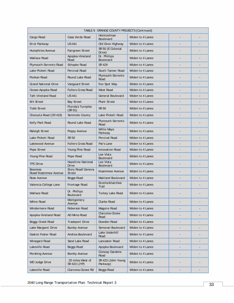
TABLE 9: ORANGE COUNTY PROJECTS (Continued)
Cargo Road Casa Verde Road Heintzelman Boulevard Widen to 4 Lanes - -
Errol Parkway US 441 Old Dixie Highway Widen to 4 Lanes - -
Humphries Avenue Fairgreen Street SR 50 (E Colonial Drive) Widen to 4 Lanes - -
Wallace Road Apopka-Vineland Road
Dr. Phillips Boulevard Widen to 4 Lanes - -
Plymouth-Sorrento Road Schopke Road SR 429 Widen to 4 Lanes - -
Lake Pickett Road Percival Road South Tanner Road Widen to 4 Lanes - -
Ponkan Road Round Lake Road Plymouth-Sorrento Road Widen to 4 Lanes - -
Grand National Drive Vanguard Street Fun Spot Way Widen to 4 Lanes - -
Ocoee-Apopka Road Fullers Cross Road West Road Widen to 4 Lanes - -
Taft-Vineland Road US 441 General Boulevard Widen to 4 Lanes - -
9th Street Bay Street Plant Street Widen to 4 Lanes - -
Tubb Street Florida's Turnpike (SR 91) SR 50 Widen to 4 Lanes - -
Chuluota Road (CR 419) Seminole County Lake Pickett Road Widen to 4 Lanes - -
Kelly Park Road Round Lake Road Plymouth-Sorrento Road Widen to 4 Lanes - -
Raleigh Street Poppy Avenue Willie Mays Parkway Widen to 4 Lanes - -
Lake Pickett Road SR 50 Percival Road Widen to 4 Lanes - -
Lakewood Avenue Fullers Cross Road Pat's Lane Widen to 4 Lanes - -
Pope Street Young Pine Road Innovation Road Widen to 4 Lanes - -
Young Pine Road Pope Road Lee Vista Boulevard Widen to 4 Lanes - -
TPC Drive Hazeltine National Drive
Lee Vista Boulevard Widen to 4 Lanes - -
Bowness Road/Kissimmee Avenue
Story Road/Geneva Street Kissimmee Avenue Widen to 4 Lanes - -
Rose Avenue Beggs Road Maitland Boulevard Widen to 4 Lanes - -
Valencia College Lane Frontage Road Econlockhatchee Trail Widen to 4 Lanes - -
Wallace Road Dr. Phillips Boulevard Turkey Lake Road Widen to 4 Lanes - -
White Road Montgomery Avenue Clarke Road Widen to 4 Lanes - -
Windermere Road Roberson Road Maguire Road Widen to 4 Lanes - -
Apopka-Vineland Road AD Mims Road Clarcona-Ocoee Road Widen to 4 Lanes - -
Boggy Creek Road Tradeport Drive Dowden Road Widen to 4 Lanes - -
Lake Margaret Drive Bumby Avenue Semoran Boulevard Widen to 4 Lanes - -
Gaston Foster Road Andrea Boulevard Lake Underhill Road Widen to 4 Lanes - -
Winegard Road Sand Lake Road Lancaster Road Widen to 4 Lanes - -
Lakeville Road Beggs Road Apopka Boulevard Widen to 4 Lanes - -
Pershing Avenue Bumby Avenue Conway Gardens Road Widen to 4 Lanes - -
WD Judge Drive .25 miles West of SR 423 (JYP)
SR 423 (John Young Parkway) Widen to 4 Lanes - -
Lakeville Road Clarcona-Ocoee Rd Beggs Road Widen to 4 Lanes - -
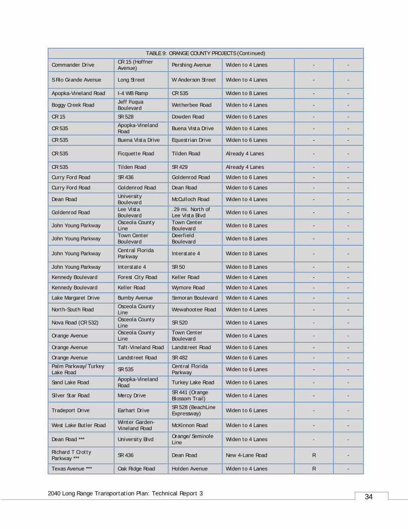
34
2040 Long Range Transportation Plan: Technical Report 3
TABLE 9: ORANGE COUNTY PROJECTS (Continued)
Commander Drive CR 15 (Hoffner Avenue) Pershing Avenue Widen to 4 Lanes - -
S Rio Grande Avenue Long Street W Anderson Street Widen to 4 Lanes - -
Apopka-Vineland Road I-4 WB Ramp CR 535 Widen to 8 Lanes - -
Boggy Creek Road Jeff Fuqua Boulevard Wetherbee Road Widen to 4 Lanes - -
CR 15 SR 528 Dowden Road Widen to 6 Lanes - -
CR 535 Apopka-Vineland Road Buena Vista Drive Widen to 4 Lanes - -
CR 535 Buena Vista Drive Equestrian Drive Widen to 6 Lanes - -
CR 535 Ficquette Road Tilden Road Already 4 Lanes - -
CR 535 Tilden Road SR 429 Already 4 Lanes - -
Curry Ford Road SR 436 Goldenrod Road Widen to 6 Lanes - -
Curry Ford Road Goldenrod Road Dean Road Widen to 6 Lanes - -
Dean Road University Boulevard McCulloch Road Widen to 4 Lanes - -
Goldenrod Road Lee Vista Boulevard
.29 mi. North of Lee Vista Blvd Widen to 6 Lanes - -
John Young Parkway Osceola County Line
Town Center Boulevard Widen to 8 Lanes - -
John Young Parkway Town Center Boulevard
Deerfield Boulevard Widen to 8 Lanes - -
John Young Parkway Central Florida Parkway Interstate 4 Widen to 8 Lanes - -
John Young Parkway Interstate 4 SR 50 Widen to 8 Lanes - -
Kennedy Boulevard Forest City Road Keller Road Widen to 4 Lanes - -
Kennedy Boulevard Keller Road Wymore Road Widen to 4 Lanes - -
Lake Margaret Drive Bumby Avenue Semoran Boulevard Widen to 4 Lanes - -
North-South Road Osceola County Line Wewahootee Road Widen to 4 Lanes - -
Nova Road (CR 532) Osceola County Line SR 520 Widen to 4 Lanes - -
Orange Avenue Osceola County Line
Town Center Boulevard Widen to 4 Lanes - -
Orange Avenue Taft-Vineland Road Landstreet Road Widen to 6 Lanes - -
Orange Avenue Landstreet Road SR 482 Widen to 6 Lanes - -
Palm Parkway/Turkey Lake Road SR 535 Central Florida
Parkway Widen to 6 Lanes - -
Sand Lake Road Apopka-Vineland Road Turkey Lake Road Widen to 6 Lanes - -
Silver Star Road Mercy Drive SR 441 (Orange Blossom Trail) Widen to 4 Lanes - -
Tradeport Drive Earhart Drive SR 528 (BeachLine Expressway) Widen to 6 Lanes - -
West Lake Butler Road Winter Garden-Vineland Road McKinnon Road Widen to 4 Lanes - -
Dean Road *** University Blvd Orange/Seminole Line Widen to 4 Lanes - -
Richard T Crotty Parkway *** SR 436 Dean Road New 4-Lane Road R -
Texas Avenue *** Oak Ridge Road Holden Avenue Widen to 4 Lanes R -

35
2040 Long Range Transportation Plan: Technical Report 3
TABLE 9: ORANGE COUNTY PROJECTS (Continued)
Augusta National Drive *** SR 15 Bent Pine Dr. New 2 Lane Road D,R -
Pres Barack Obama Parkway *** Metrowest Blvd. Old Winter Garden
Rd New 4 Lane Road & New 2 Lane Extension
D,R -
Boone Ave Extension *** Anderson Street Sylvia Lane New 2 Lane Road D,R - Hazeltine National Drive *** Goldenrod Road Narcoossee Road New 4 Lane Road D,R -
Terry Ave *** Washington Street Colonial Drive New 2 Lane Road D,R -
* Transportation Improvement Program (TIP 2016-2020) ** Refer to Prioritized Project List (PPL) *** Refer to FY14/15 - FY18/19 Transportation Improvement Program (TIP) P = Project Development & Engineering (PD&E), D = Design, R = Right of Way (ROW), C = Construction
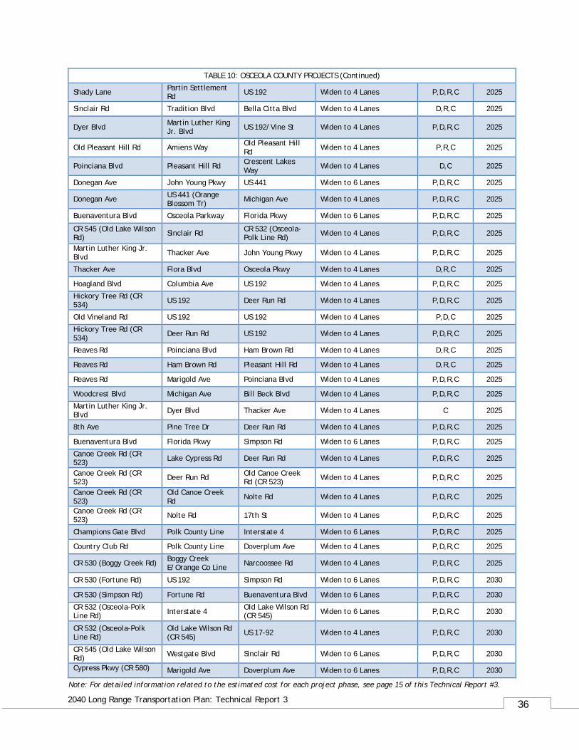
Table 10: OSCEOLA COUNTY PROJECTS
Roadway From To Improvement Phase(s) Funded by
Oak St Central Ave US 192 Widen to 4 Lanes D,R,C 2020*
Neptune Rd Old Canoe Creek Rd US 192 Widen to 4 Lanes D,R,C 2020*
Hoagland Blvd ** 500' W of Pleasant Hill Blvd John Young Pkwy Widen to 6 Lanes D,R,C 2020*
CR 530 (Simpson Rd) Osceola Pkwy Boggy Creek E/ Orange Co Widen to 4 Lanes R,C 2020*
Hoagland Blvd ** 5th St 500' W of Pleasant Hill Blvd Widen to 4 Lanes D,R,C 2020*
Canoe Creek Rd (CR 523) 17th St US 192 Widen to 4 Lanes P,D,R,C 2020*
Neptune Rd Partin Settlement Rd Henry Partin Rd Widen to 4 Lanes D,R,C 2020*
Neptune Rd Henry Partin Rd Old Canoe Creek Rd Widen to 4 Lanes D,R,C 2020*
CR 530 (Simpson Rd) Buenaventura Blvd Osceola Pkwy Widen to 6 Lanes R,C 2020*
Old Canoe Creek Rd Canoe Creek Rd (CR 523) Kissimmee Park Rd Widen to 4 Lanes D,R,C 2020*
Poinciana Blvd Old Tampa Hwy Oren Brown Rd Widen to 4 Lanes R,C 2020*
Central Ave US 192 Donegan Ave Widen to 4 Lanes R,C 2020*
Orange Ave Osceola Pkwy Orange Co. Line Widen to 4 Lanes R,C 2020*
Westside Blvd Bella Citta Blvd. Florence Villa Grove Rd Widen to 4 Lanes D,R,C 2020*
Carroll St John Young Pkwy US 441 (Orange Blossom Tr) Widen to 4 Lanes P,D,R,C 2020*
Carroll St US 441 (Orange Blossom Tr) Old Dixie Hwy Widen to 4 Lanes P,D,R,C 2020*
Carroll St Old Dixie Hwy Michigan Ave Widen to 4 Lanes P,D,R,C 2020*
Carroll St Columbia Ave John Young Pkwy Widen to 4 Lanes D,R,C 2025
Dyer Blvd Donegan Ave Carroll St Widen to 4 Lanes R,C 2025
Dyer Blvd Carroll St Osceola Pkwy Widen to 6 Lanes C 2025
Bill Beck Blvd Boggy Creek Rd Orange Ave Widen to 2 Lanes P,D,R,C 2025
Michigan Ave Mill Slough Rd Carroll St Widen to 6 Lanes P,D,R,C 2025
Michigan Ave Carroll St Mill Run Blvd Widen to 4 Lanes P,D,R,C 2025
Reaves Rd/Mac Overstreet Rd Pleasant Hill Rd Lake Toho Widen to 4 Lanes P,D,C 2025
Note: For detailed information related to the estimated cost for each project phase, see page 15 of this Technical Report #3.
36
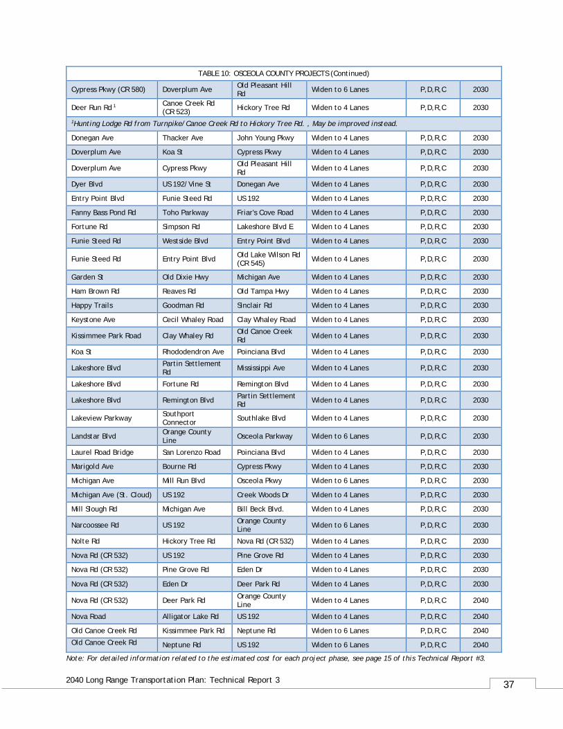
2040 Long Range Transportation Plan: Technical Report 3
TABLE 10: OSCEOLA COUNTY PROJECTS (Continued)
Shady Lane Partin Settlement Rd US 192 Widen to 4 Lanes P,D,R,C 2025
Sinclair Rd Tradition Blvd Bella Citta Blvd Widen to 4 Lanes D,R,C 2025
Dyer Blvd Martin Luther King Jr. Blvd US 192/Vine St Widen to 4 Lanes P,D,R,C 2025
Old Pleasant Hill Rd Amiens Way Old Pleasant Hill Rd Widen to 4 Lanes P,R,C 2025
Poinciana Blvd Pleasant Hill Rd Crescent Lakes Way Widen to 4 Lanes D,C 2025
Donegan Ave John Young Pkwy US 441 Widen to 6 Lanes P,D,R,C 2025
Donegan Ave US 441 (Orange Blossom Tr) Michigan Ave Widen to 4 Lanes P,D,R,C 2025
Buenaventura Blvd Osceola Parkway Florida Pkwy Widen to 6 Lanes P,D,R,C 2025
CR 545 (Old Lake Wilson Rd) Sinclair Rd CR 532 (Osceola-
Polk Line Rd) Widen to 4 Lanes P,D,R,C 2025
Martin Luther King Jr. Blvd Thacker Ave John Young Pkwy Widen to 4 Lanes P,D,R,C 2025
Thacker Ave Flora Blvd Osceola Pkwy Widen to 4 Lanes D,R,C 2025
Hoagland Blvd Columbia Ave US 192 Widen to 4 Lanes P,D,R,C 2025
Hickory Tree Rd (CR 534) US 192 Deer Run Rd Widen to 4 Lanes P,D,R,C 2025
Old Vineland Rd US 192 US 192 Widen to 4 Lanes P,D,C 2025
Hickory Tree Rd (CR 534) Deer Run Rd US 192 Widen to 4 Lanes P,D,R,C 2025
Reaves Rd Poinciana Blvd Ham Brown Rd Widen to 4 Lanes D,R,C 2025
Reaves Rd Ham Brown Rd Pleasant Hill Rd Widen to 4 Lanes D,R,C 2025
Reaves Rd Marigold Ave Poinciana Blvd Widen to 4 Lanes P,D,R,C 2025
Woodcrest Blvd Michigan Ave Bill Beck Blvd Widen to 4 Lanes P,D,R,C 2025
Martin Luther King Jr. Blvd Dyer Blvd Thacker Ave Widen to 4 Lanes C 2025
8th Ave Pine Tree Dr Deer Run Rd Widen to 4 Lanes P,D,R,C 2025
Buenaventura Blvd Florida Pkwy Simpson Rd Widen to 6 Lanes P,D,R,C 2025
Canoe Creek Rd (CR 523) Lake Cypress Rd Deer Run Rd Widen to 4 Lanes P,D,R,C 2025
Canoe Creek Rd (CR 523) Deer Run Rd Old Canoe Creek
Rd (CR 523) Widen to 4 Lanes P,D,R,C 2025
Canoe Creek Rd (CR 523)
Old Canoe Creek Rd Nolte Rd Widen to 4 Lanes P,D,R,C 2025
Canoe Creek Rd (CR 523) Nolte Rd 17th St Widen to 4 Lanes P,D,R,C 2025
Champions Gate Blvd Polk County Line Interstate 4 Widen to 6 Lanes P,D,R,C 2025
Country Club Rd Polk County Line Doverplum Ave Widen to 4 Lanes P,D,R,C 2025
CR 530 (Boggy Creek Rd) Boggy Creek E/Orange Co Line Narcoossee Rd Widen to 4 Lanes P,D,R,C 2025
CR 530 (Fortune Rd) US 192 Simpson Rd Widen to 6 Lanes P,D,R,C 2030
CR 530 (Simpson Rd) Fortune Rd Buenaventura Blvd Widen to 6 Lanes P,D,R,C 2030
CR 532 (Osceola-Polk Line Rd) Interstate 4 Old Lake Wilson Rd
(CR 545) Widen to 6 Lanes P,D,R,C 2030
CR 532 (Osceola-Polk Line Rd)
Old Lake Wilson Rd (CR 545) US 17-92 Widen to 4 Lanes P,D,R,C 2030
CR 545 (Old Lake Wilson Rd) Westgate Blvd Sinclair Rd Widen to 6 Lanes P,D,R,C 2030
Cypress Pkwy (CR 580) Marigold Ave Doverplum Ave Widen to 6 Lanes P,D,R,C 2030
Note: For detailed information related to the estimated cost for each project phase, see page 15 of this Technical Report #3.
37
2040 Long Range Transportation Plan: Technical Report 3
Note: For detailed information related to the estimated cost for each project phase, see page 15 of this Technical Report #3.
TABLE 10: OSCEOLA COUNTY PROJECTS (Continued)
Cypress Pkwy (CR 580) Doverplum Ave Old Pleasant Hill Rd Widen to 6 Lanes P,D,R,C 2030
Deer Run Rd 1 Canoe Creek Rd (CR 523) Hickory Tree Rd Widen to 4 Lanes P,D,R,C 2030
1Hunting Lodge Rd from Turnpike/Canoe Creek Rd to Hickory Tree Rd. , May be improved instead.
Donegan Ave Thacker Ave John Young Pkwy Widen to 4 Lanes P,D,R,C 2030
Doverplum Ave Koa St Cypress Pkwy Widen to 4 Lanes P,D,R,C 2030
Doverplum Ave Cypress Pkwy Old Pleasant Hill Rd Widen to 4 Lanes P,D,R,C 2030
Dyer Blvd US 192/Vine St Donegan Ave Widen to 4 Lanes P,D,R,C 2030
Entry Point Blvd Funie Steed Rd US 192 Widen to 4 Lanes P,D,R,C 2030
Fanny Bass Pond Rd Toho Parkway Friar's Cove Road Widen to 4 Lanes P,D,R,C 2030
Fortune Rd Simpson Rd Lakeshore Blvd E Widen to 4 Lanes P,D,R,C 2030
Funie Steed Rd Westside Blvd Entry Point Blvd Widen to 4 Lanes P,D,R,C 2030
Funie Steed Rd Entry Point Blvd Old Lake Wilson Rd (CR 545) Widen to 4 Lanes P,D,R,C 2030
Garden St Old Dixie Hwy Michigan Ave Widen to 4 Lanes P,D,R,C 2030
Ham Brown Rd Reaves Rd Old Tampa Hwy Widen to 4 Lanes P,D,R,C 2030
Happy Trails Goodman Rd Sinclair Rd Widen to 4 Lanes P,D,R,C 2030
Keystone Ave Cecil Whaley Road Clay Whaley Road Widen to 4 Lanes P,D,R,C 2030
Kissimmee Park Road Clay Whaley Rd Old Canoe Creek Rd Widen to 4 Lanes P,D,R,C 2030
Koa St Rhododendron Ave Poinciana Blvd Widen to 4 Lanes P,D,R,C 2030
Lakeshore Blvd Partin Settlement Rd Mississippi Ave Widen to 4 Lanes P,D,R,C 2030
Lakeshore Blvd Fortune Rd Remington Blvd Widen to 4 Lanes P,D,R,C 2030
Lakeshore Blvd Remington Blvd Partin Settlement Rd Widen to 4 Lanes P,D,R,C 2030
Lakeview Parkway Southport Connector Southlake Blvd Widen to 4 Lanes P,D,R,C 2030
Landstar Blvd Orange County Line Osceola Parkway Widen to 6 Lanes P,D,R,C 2030
Laurel Road Bridge San Lorenzo Road Poinciana Blvd Widen to 4 Lanes P,D,R,C 2030
Marigold Ave Bourne Rd Cypress Pkwy Widen to 4 Lanes P,D,R,C 2030
Michigan Ave Mill Run Blvd Osceola Pkwy Widen to 6 Lanes P,D,R,C 2030
Michigan Ave (St. Cloud) US 192 Creek Woods Dr Widen to 4 Lanes P,D,R,C 2030
Mill Slough Rd Michigan Ave Bill Beck Blvd. Widen to 4 Lanes P,D,R,C 2030
Narcoossee Rd US 192 Orange County Line Widen to 6 Lanes P,D,R,C 2030
Nolte Rd Hickory Tree Rd Nova Rd (CR 532) Widen to 4 Lanes P,D,R,C 2030
Nova Rd (CR 532) US 192 Pine Grove Rd Widen to 4 Lanes P,D,R,C 2030
Nova Rd (CR 532) Pine Grove Rd Eden Dr Widen to 4 Lanes P,D,R,C 2030
Nova Rd (CR 532) Eden Dr Deer Park Rd Widen to 4 Lanes P,D,R,C 2030
Nova Rd (CR 532) Deer Park Rd Orange County Line Widen to 4 Lanes P,D,R,C 2040
Nova Road Alligator Lake Rd US 192 Widen to 4 Lanes P,D,R,C 2040
Old Canoe Creek Rd Kissimmee Park Rd Neptune Rd Widen to 6 Lanes P,D,R,C 2040
Old Canoe Creek Rd Neptune Rd US 192 Widen to 6 Lanes P,D,R,C 2040
38
2040 Long Range Transportation Plan: Technical Report 3
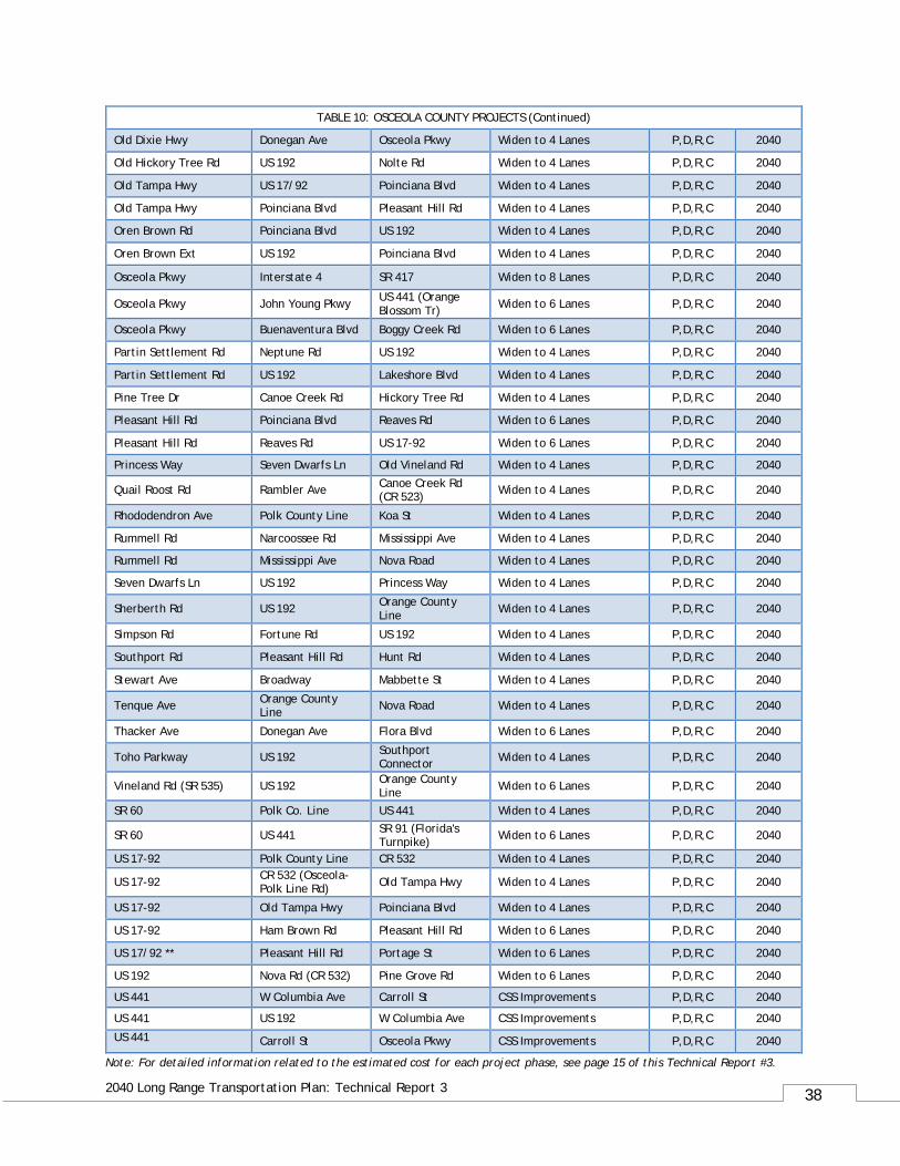
Note: For detailed information related to the estimated cost for each project phase, see page 15 of this Technical Report #3.
TABLE 10: OSCEOLA COUNTY PROJECTS (Continued)
Old Dixie Hwy Donegan Ave Osceola Pkwy Widen to 4 Lanes P,D,R,C 2040
Old Hickory Tree Rd US 192 Nolte Rd Widen to 4 Lanes P,D,R,C 2040
Old Tampa Hwy US 17/92 Poinciana Blvd Widen to 4 Lanes P,D,R,C 2040
Old Tampa Hwy Poinciana Blvd Pleasant Hill Rd Widen to 4 Lanes P,D,R,C 2040
Oren Brown Rd Poinciana Blvd US 192 Widen to 4 Lanes P,D,R,C 2040
Oren Brown Ext US 192 Poinciana Blvd Widen to 4 Lanes P,D,R,C 2040
Osceola Pkwy Interstate 4 SR 417 Widen to 8 Lanes P,D,R,C 2040
Osceola Pkwy John Young Pkwy US 441 (Orange Blossom Tr) Widen to 6 Lanes P,D,R,C 2040
Osceola Pkwy Buenaventura Blvd Boggy Creek Rd Widen to 6 Lanes P,D,R,C 2040
Partin Settlement Rd Neptune Rd US 192 Widen to 4 Lanes P,D,R,C 2040
Partin Settlement Rd US 192 Lakeshore Blvd Widen to 4 Lanes P,D,R,C 2040
Pine Tree Dr Canoe Creek Rd Hickory Tree Rd Widen to 4 Lanes P,D,R,C 2040
Pleasant Hill Rd Poinciana Blvd Reaves Rd Widen to 6 Lanes P,D,R,C 2040
Pleasant Hill Rd Reaves Rd US 17-92 Widen to 6 Lanes P,D,R,C 2040
Princess Way Seven Dwarfs Ln Old Vineland Rd Widen to 4 Lanes P,D,R,C 2040
Quail Roost Rd Rambler Ave Canoe Creek Rd (CR 523) Widen to 4 Lanes P,D,R,C 2040
Rhododendron Ave Polk County Line Koa St Widen to 4 Lanes P,D,R,C 2040
Rummell Rd Narcoossee Rd Mississippi Ave Widen to 4 Lanes P,D,R,C 2040
Rummell Rd Mississippi Ave Nova Road Widen to 4 Lanes P,D,R,C 2040
Seven Dwarfs Ln US 192 Princess Way Widen to 4 Lanes P,D,R,C 2040
Sherberth Rd US 192 Orange County Line Widen to 4 Lanes P,D,R,C 2040
Simpson Rd Fortune Rd US 192 Widen to 4 Lanes P,D,R,C 2040
Southport Rd Pleasant Hill Rd Hunt Rd Widen to 4 Lanes P,D,R,C 2040
Stewart Ave Broadway Mabbette St Widen to 4 Lanes P,D,R,C 2040
Tenque Ave Orange County Line Nova Road Widen to 4 Lanes P,D,R,C 2040
Thacker Ave Donegan Ave Flora Blvd Widen to 6 Lanes P,D,R,C 2040
Toho Parkway US 192 Southport Connector Widen to 4 Lanes P,D,R,C 2040
Vineland Rd (SR 535) US 192 Orange County Line Widen to 6 Lanes P,D,R,C 2040
SR 60 Polk Co. Line US 441 Widen to 4 Lanes P,D,R,C 2040
SR 60 US 441 SR 91 (Florida's Turnpike) Widen to 6 Lanes P,D,R,C 2040
US 17-92 Polk County Line CR 532 Widen to 4 Lanes P,D,R,C 2040
US 17-92 CR 532 (Osceola-Polk Line Rd) Old Tampa Hwy Widen to 4 Lanes P,D,R,C 2040
US 17-92 Old Tampa Hwy Poinciana Blvd Widen to 4 Lanes P,D,R,C 2040
US 17-92 Ham Brown Rd Pleasant Hill Rd Widen to 6 Lanes P,D,R,C 2040
US 17/92 ** Pleasant Hill Rd Portage St Widen to 6 Lanes P,D,R,C 2040
US 192 Nova Rd (CR 532) Pine Grove Rd Widen to 6 Lanes P,D,R,C 2040
US 441 W Columbia Ave Carroll St CSS Improvements P,D,R,C 2040
US 441 US 192 W Columbia Ave CSS Improvements P,D,R,C 2040
US 441 Carroll St Osceola Pkwy CSS Improvements P,D,R,C 2040
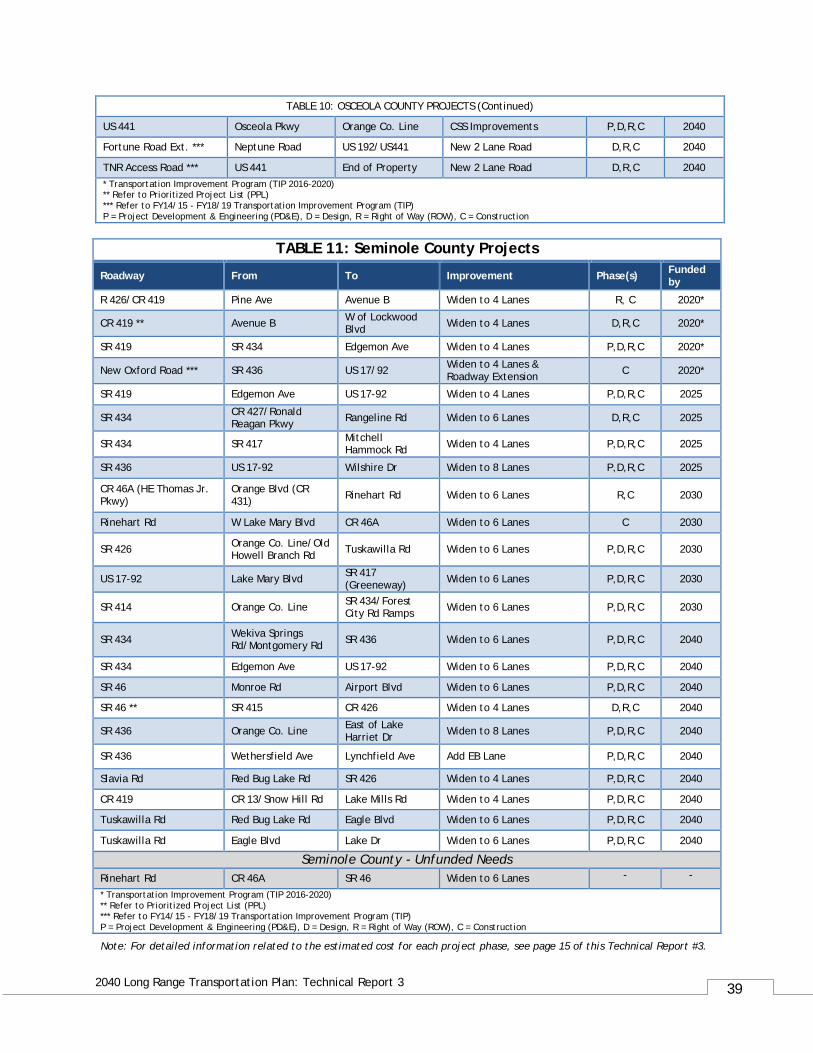
39
2040 Long Range Transportation Plan: Technical Report 3
TABLE 10: OSCEOLA COUNTY PROJECTS (Continued)
US 441 Osceola Pkwy Orange Co. Line CSS Improvements P,D,R,C 2040
Fortune Road Ext. *** Neptune Road US 192/US441 New 2 Lane Road D,R,C 2040
TNR Access Road *** US 441 End of Property New 2 Lane Road D,R,C 2040 * Transportation Improvement Program (TIP 2016-2020) ** Refer to Prioritized Project List (PPL) *** Refer to FY14/15 - FY18/19 Transportation Improvement Program (TIP) P = Project Development & Engineering (PD&E), D = Design, R = Right of Way (ROW), C = Construction
TABLE 11: Seminole County Projects
Roadway From To Improvement Phase(s) Funded by
R 426/CR 419 Pine Ave Avenue B Widen to 4 Lanes R, C 2020*
CR 419 ** Avenue B W of Lockwood Blvd Widen to 4 Lanes D,R,C 2020*
SR 419 SR 434 Edgemon Ave Widen to 4 Lanes P,D,R,C 2020*
New Oxford Road *** SR 436 US 17/92 Widen to 4 Lanes & Roadway Extension C 2020*
SR 419 Edgemon Ave US 17-92 Widen to 4 Lanes P,D,R,C 2025
SR 434 CR 427/Ronald Reagan Pkwy Rangeline Rd Widen to 6 Lanes D,R,C 2025
SR 434 SR 417 Mitchell Hammock Rd Widen to 4 Lanes P,D,R,C 2025
SR 436 US 17-92 Wilshire Dr Widen to 8 Lanes P,D,R,C 2025
CR 46A (HE Thomas Jr. Pkwy)
Orange Blvd (CR 431) Rinehart Rd Widen to 6 Lanes R,C 2030
Rinehart Rd W Lake Mary Blvd CR 46A Widen to 6 Lanes C 2030
SR 426 Orange Co. Line/Old Howell Branch Rd Tuskawilla Rd Widen to 6 Lanes P,D,R,C 2030
US 17-92 Lake Mary Blvd SR 417 (Greeneway) Widen to 6 Lanes P,D,R,C 2030
SR 414 Orange Co. Line SR 434/Forest City Rd Ramps Widen to 6 Lanes P,D,R,C 2030
SR 434 Wekiva Springs Rd/Montgomery Rd SR 436 Widen to 6 Lanes P,D,R,C 2040
SR 434 Edgemon Ave US 17-92 Widen to 6 Lanes P,D,R,C 2040
SR 46 Monroe Rd Airport Blvd Widen to 6 Lanes P,D,R,C 2040
SR 46 ** SR 415 CR 426 Widen to 4 Lanes D,R,C 2040
SR 436 Orange Co. Line East of Lake Harriet Dr Widen to 8 Lanes P,D,R,C 2040
SR 436 Wethersfield Ave Lynchfield Ave Add EB Lane P,D,R,C 2040
Slavia Rd Red Bug Lake Rd SR 426 Widen to 4 Lanes P,D,R,C 2040
CR 419 CR 13/Snow Hill Rd Lake Mills Rd Widen to 4 Lanes P,D,R,C 2040
Tuskawilla Rd Red Bug Lake Rd Eagle Blvd Widen to 6 Lanes P,D,R,C 2040
Tuskawilla Rd Eagle Blvd Lake Dr Widen to 6 Lanes P,D,R,C 2040
Seminole County - Unfunded Needs Rinehart Rd CR 46A SR 46 Widen to 6 Lanes - -
* Transportation Improvement Program (TIP 2016-2020) ** Refer to Prioritized Project List (PPL) *** Refer to FY14/15 - FY18/19 Transportation Improvement Program (TIP) P = Project Development & Engineering (PD&E), D = Design, R = Right of Way (ROW), C = Construction
Note: For detailed information related to the estimated cost for each project phase, see page 15 of this Technical Report #3.
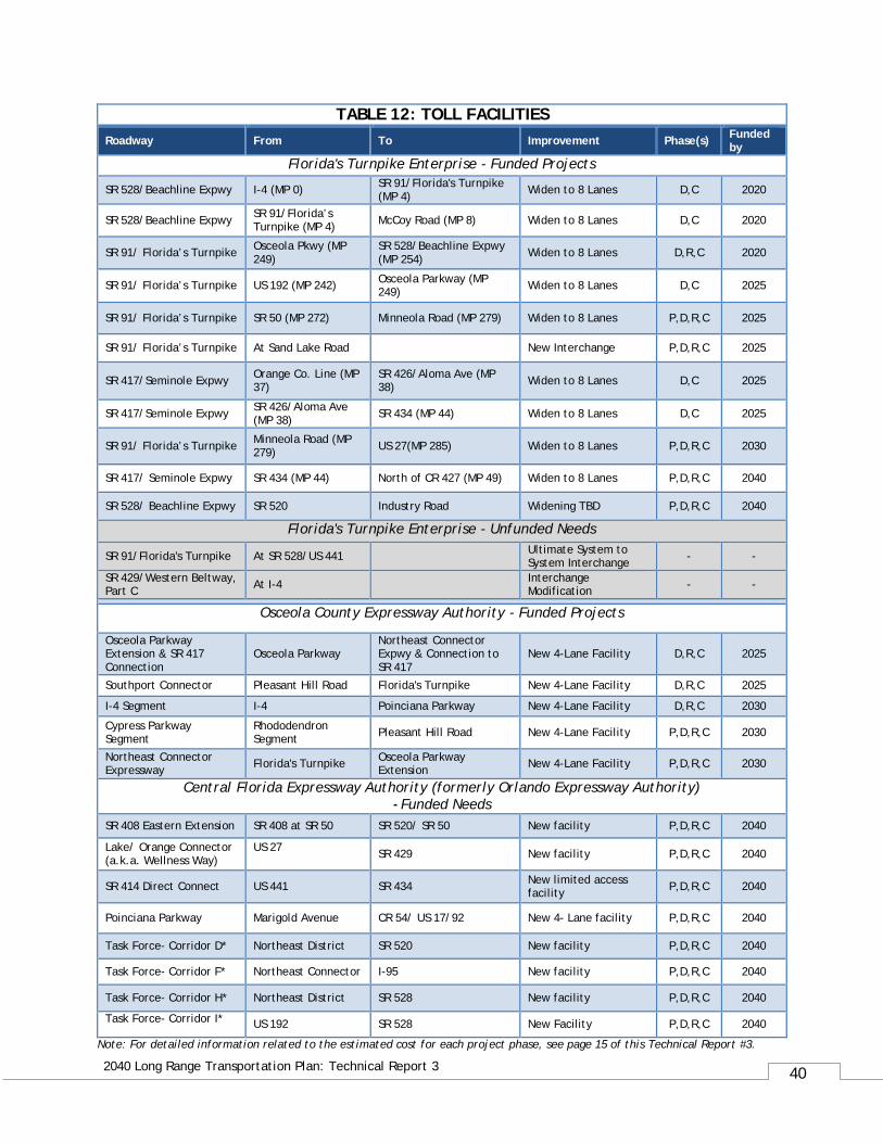
40
2040 Long Range Transportation Plan: Technical Report 3
Note: For detailed information related to the estimated cost for each project phase, see page 15 of this Technical Report #3.
TABLE 12: TOLL FACILITIES Roadway From To Improvement Phase(s) Funded
by Florida's Turnpike Enterprise - Funded Projects
SR 528/Beachline Expwy I-4 (MP 0) SR 91/Florida's Turnpike (MP 4) Widen to 8 Lanes D,C 2020
SR 528/Beachline Expwy SR 91/Florida’s Turnpike (MP 4) McCoy Road (MP 8) Widen to 8 Lanes D,C 2020
SR 91/ Florida’s Turnpike Osceola Pkwy (MP 249)
SR 528/Beachline Expwy (MP 254) Widen to 8 Lanes D,R,C 2020
SR 91/ Florida’s Turnpike US 192 (MP 242) Osceola Parkway (MP 249) Widen to 8 Lanes D,C 2025
SR 91/ Florida’s Turnpike SR 50 (MP 272) Minneola Road (MP 279) Widen to 8 Lanes P,D,R,C 2025
SR 91/ Florida’s Turnpike At Sand Lake Road New Interchange P,D,R,C 2025
SR 417/Seminole Expwy Orange Co. Line (MP 37)
SR 426/Aloma Ave (MP 38) Widen to 8 Lanes D,C 2025
SR 417/Seminole Expwy SR 426/Aloma Ave (MP 38) SR 434 (MP 44) Widen to 8 Lanes D,C 2025
SR 91/ Florida’s Turnpike Minneola Road (MP 279) US 27(MP 285) Widen to 8 Lanes P,D,R,C 2030
SR 417/ Seminole Expwy SR 434 (MP 44) North of CR 427 (MP 49) Widen to 8 Lanes P,D,R,C 2040
SR 528/ Beachline Expwy SR 520 Industry Road Widening TBD P,D,R,C 2040
Florida's Turnpike Enterprise - Unfunded Needs
SR 91/Florida's Turnpike At SR 528/US 441 Ultimate System to System Interchange - -
SR 429/Western Beltway, Part C At I-4 Interchange
Modification - -
Osceola County Expressway Authority - Funded Projects
Osceola Parkway Extension & SR 417 Connection
Osceola Parkway Northeast Connector Expwy & Connection to SR 417
New 4-Lane Facility D,R,C 2025
Southport Connector Pleasant Hill Road Florida's Turnpike New 4-Lane Facility D,R,C 2025
I-4 Segment I-4 Poinciana Parkway New 4-Lane Facility D,R,C 2030
Cypress Parkway Segment
Rhododendron Segment Pleasant Hill Road New 4-Lane Facility P,D,R,C 2030
Northeast Connector Expressway Florida's Turnpike Osceola Parkway
Extension New 4-Lane Facility P,D,R,C 2030
Central Florida Expressway Authority (formerly Orlando Expressway Authority) - Funded Needs
SR 408 Eastern Extension SR 408 at SR 50 SR 520/ SR 50 New facility P,D,R,C 2040
Lake/ Orange Connector (a.k.a. Wellness Way)
US 27 SR 429 New facility P,D,R,C 2040
SR 414 Direct Connect US 441 SR 434 New limited access facility P,D,R,C 2040
Poinciana Parkway Marigold Avenue CR 54/ US 17/92 New 4- Lane facility P,D,R,C 2040
Task Force- Corridor D* Northeast District SR 520 New facility P,D,R,C 2040
Task Force- Corridor F* Northeast Connector I-95 New facility P,D,R,C 2040
Task Force- Corridor H* Northeast District SR 528 New facility P,D,R,C 2040
Task Force- Corridor I* US 192 SR 528 New Facility P,D,R,C 2040
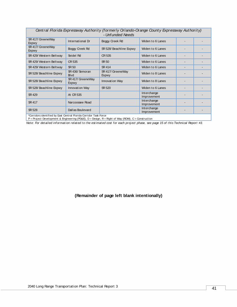
41
2040 Long Range Transportation Plan: Technical Report 3
Note: For detailed information related to the estimated cost for each project phase, see page 15 of this Technical Report #3.
Central Florida Expressway Authority (formerly Orlando-Orange County Expressway Authority) - Unfunded Needs
SR 417/GreeneWay Expwy International Dr Boggy Creek Rd Widen to 6 Lanes - -
SR 417/GreeneWay Expwy Boggy Creek Rd SR 528/Beachline Expwy Widen to 6 Lanes - -
SR 429/Western Beltway Seidel Rd CR 535 Widen to 6 Lanes - -
SR 429/Western Beltway CR 535 SR 50 Widen to 6 Lanes - -
SR 429/Western Beltway SR 50 SR 414 Widen to 6 Lanes - -
SR 528/Beachline Expwy SR 436/Semoran Blvd
SR 417/GreeneWay Expwy Widen to 8 Lanes - -
SR 528/Beachline Expwy SR 417/GreeneWay Expwy Innovation Way Widen to 8 Lanes - -
SR 528/Beachline Expwy Innovation Way SR 520 Widen to 6 Lanes - -
SR 429 At CR 535 Interchange Improvement - -
SR 417 Narcoossee Road Interchange Improvement - -
SR 528 Dallas Boulevard Interchange Improvement - -
*Corridors identified by East Central Florida Corridor Task Force P = Project Development & Engineering (PD&E), D = Design, R = Right of Way (ROW), C = Construction
(Remainder of page left blank intentionally)
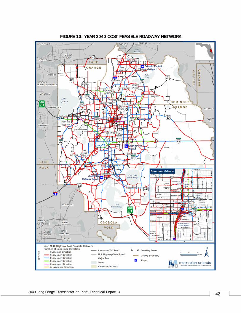
42
2040 Long Range Transportation Plan: Technical Report 3
FIGURE 10: YEAR 2040 COST FEASIBLE ROADWAY NETWORK
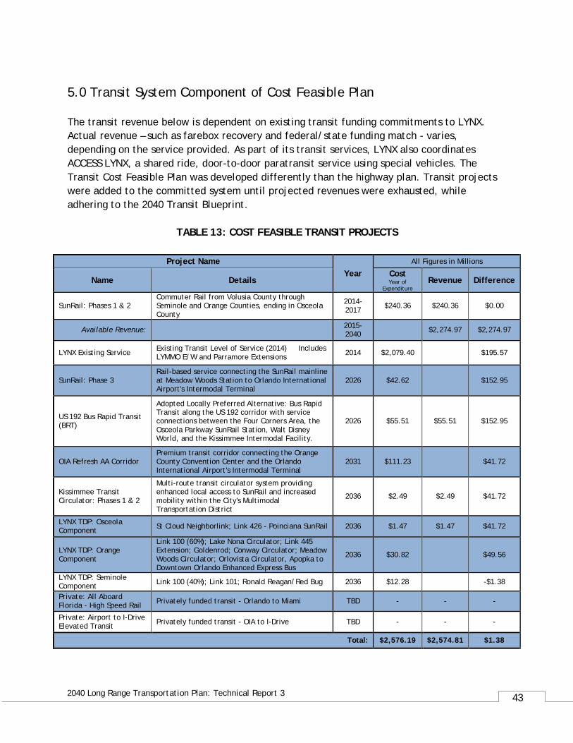
43
2040 Long Range Transportation Plan: Technical Report 3
5.0 Transit System Component of Cost Feasible Plan The transit revenue below is dependent on existing transit funding commitments to LYNX. Actual revenue – such as farebox recovery and federal/state funding match - varies, depending on the service provided. As part of its transit services, LYNX also coordinates ACCESS LYNX, a shared ride, door-to-door paratransit service using special vehicles. The Transit Cost Feasible Plan was developed differently than the highway plan. Transit projects were added to the committed system until projected revenues were exhausted, while adhering to the 2040 Transit Blueprint.
TABLE 13: COST FEASIBLE TRANSIT PROJECTS
Project Name Year
All Figures in Millions
Name Details Cost Year of
Expenditure Revenue Difference
SunRail: Phases 1 & 2 Commuter Rail from Volusia County through Seminole and Orange Counties, ending in Osceola County
2014-2017 $240.36 $240.36 $0.00
Available Revenue: 2015-2040 $2,274.97 $2,274.97
LYNX Existing Service Existing Transit Level of Service (2014) Includes LYMMO E/W and Parramore Extensions 2014 $2,079.40 $195.57
SunRail: Phase 3 Rail-based service connecting the SunRail mainline at Meadow Woods Station to Orlando International Airport's Intermodal Terminal
2026 $42.62 $152.95
US 192 Bus Rapid Transit (BRT)
Adopted Locally Preferred Alternative: Bus Rapid Transit along the US 192 corridor with service connections between the Four Corners Area, the Osceola Parkway SunRail Station, Walt Disney World, and the Kissimmee Intermodal Facility.
2026 $55.51 $55.51 $152.95
OIA Refresh AA Corridor Premium transit corridor connecting the Orange County Convention Center and the Orlando International Airport's Intermodal Terminal
2031 $111.23 $41.72
Kissimmee Transit Circulator: Phases 1 & 2
Multi-route transit circulator system providing enhanced local access to SunRail and increased mobility within the City's Multimodal Transportation District
2036 $2.49 $2.49 $41.72
LYNX TDP: Osceola Component St Cloud Neighborlink; Link 426 - Poinciana SunRail 2036 $1.47 $1.47 $41.72
LYNX TDP: Orange Component
Link 100 (60%); Lake Nona Circulator; Link 445 Extension; Goldenrod; Conway Circulator; Meadow Woods Circulator; Orlovista Circulator, Apopka to Downtown Orlando Enhanced Express Bus
2036 $30.82 $49.56
LYNX TDP: Seminole Component Link 100 (40%); Link 101; Ronald Reagan/Red Bug 2036 $12.28 -$1.38
Private: All Aboard Florida - High Speed Rail Privately funded transit - Orlando to Miami TBD - - -
Private: Airport to I-Drive Elevated Transit Privately funded transit - OIA to I-Drive TBD - - -
Total: $2,576.19 $2,574.81 $1.38
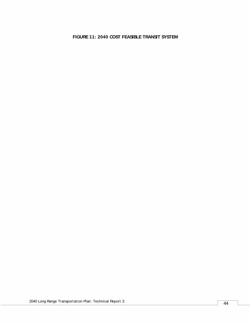
44
2040 Long Range Transportation Plan: Technical Report 3
FIGURE 11: 2040 COST FEASIBLE TRANSIT SYSTEM
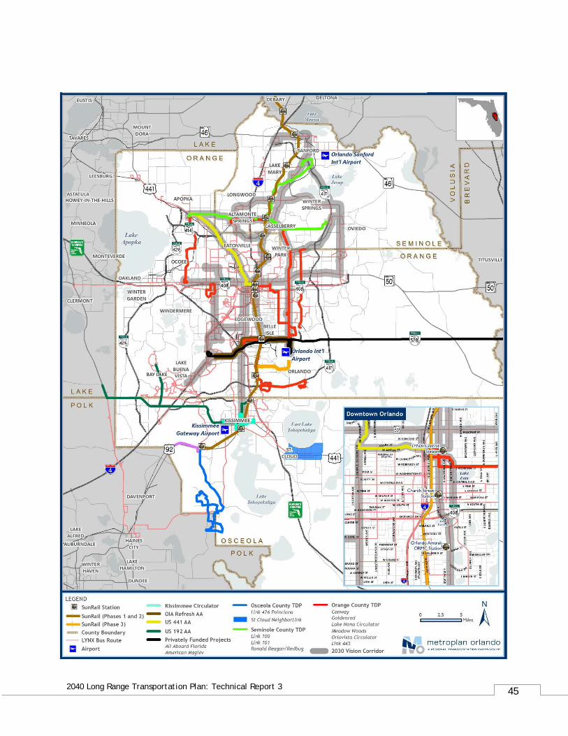
45
2040 Long Range Transportation Plan: Technical Report 3
46
2040 Long Range Transportation Plan: Technical Report 3
APPENDIX:
LIST OF HIGHWAY IMPROVEMENTS
WITH BUDGET ALLOCATION
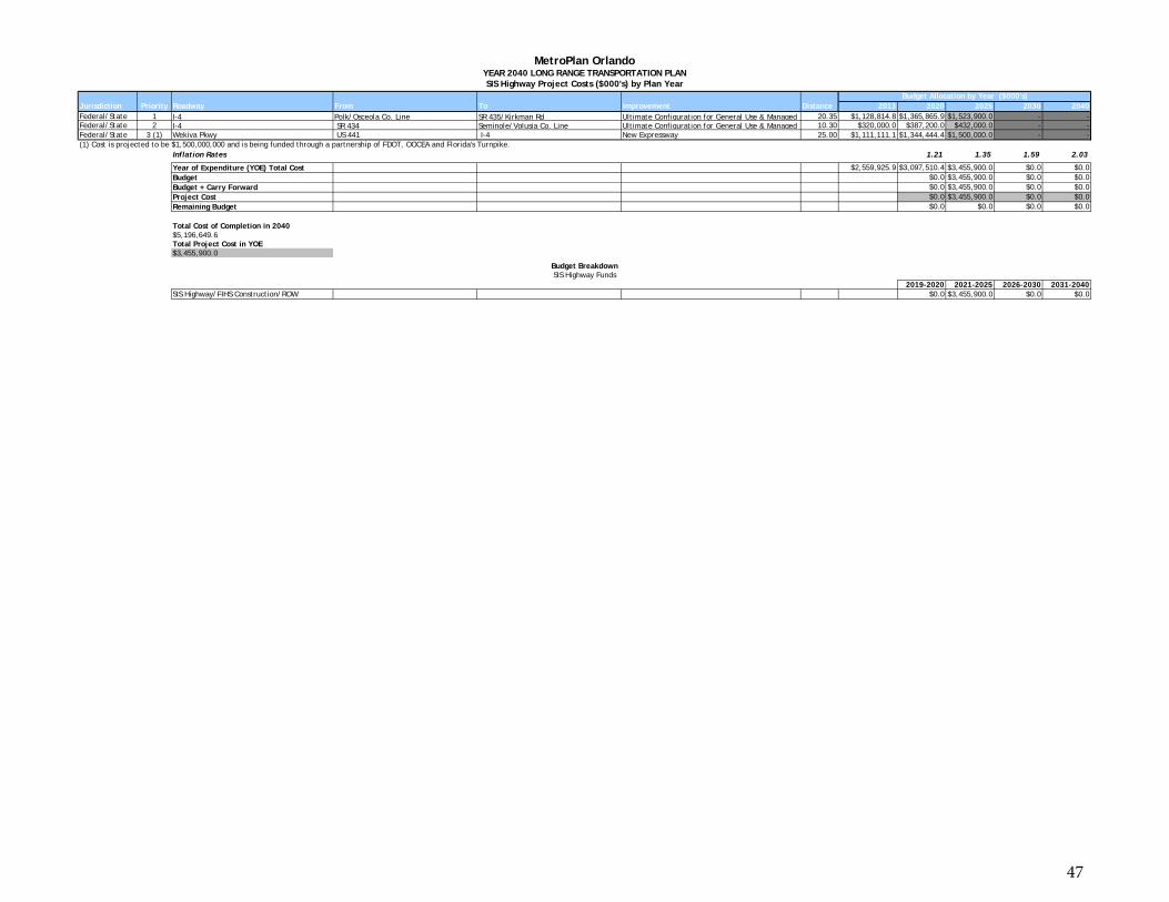
Jurisdiction Priority Roadway From To Improvement Distance 2013 2020 2025 2030 2040Federal/State 1 I-4 Polk/Osceola Co. Line SR 435/Kirkman Rd Ultimate Configuration for General Use & Managed 20.35 $1,128,814.8 $1,365,865.9 $1,523,900.0 - -Federal/State 2 I-4 SR 434 Seminole/Volusia Co. Line Ultimate Configuration for General Use & Managed 10.30 $320,000.0 $387,200.0 $432,000.0 - -Federal/State 3 (1) Wekiva Pkwy US 441 I-4 New Expressway 25.00 $1,111,111.1 $1,344,444.4 $1,500,000.0 - -(1) Cost is projected to be $1,500,000,000 and is being funded through a partnership of FDOT, OOCEA and Florida's Turnpike.
Inflation Rates 1.21 1.35 1.59 2.03
Year of Expenditure (YOE) Total Cost $2,559,925.9 $3,097,510.4 $3,455,900.0 $0.0 $0.0Budget $0.0 $3,455,900.0 $0.0 $0.0Budget + Carry Forward $0.0 $3,455,900.0 $0.0 $0.0Project Cost $0.0 $3,455,900.0 $0.0 $0.0Remaining Budget $0.0 $0.0 $0.0 $0.0
Total Cost of Completion in 2040$5,196,649.6Total Project Cost in YOE$3,455,900.0
2019-2020 2021-2025 2026-2030 2031-2040SIS Highway/FIHS Construction/ROW $0.0 $3,455,900.0 $0.0 $0.0
Budget BreakdownSIS Highway Funds
Budget Allocation by Year ($000's)
MetroPlan OrlandoYEAR 2040 LONG RANGE TRANSPORTATION PLANSIS Highway Project Costs ($000's) by Plan Year
47
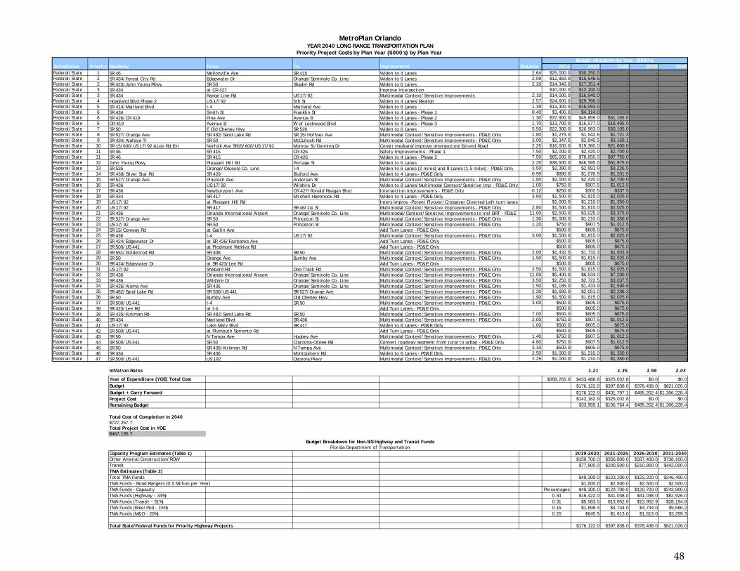
Jurisdiction Priority Roadway From To Improvement Distance 2013 2020 2025 2030 2040Federal/State 1 SR 46 Mellonville Ave SR 415 Widen to 4 Lanes 2.64 $25,000.0 $30,250.0 - - -Federal/State 2 SR 434/Forest City Rd Edgewater Dr Orange/Seminole Co. Line Widen to 6 Lanes 2.09 $12,850.0 $15,548.5 - - -Federal/State 2 SR 423/John Young Pkwy SR 50 Shader Rd Widen to 6 Lanes 2.20 $14,340.0 $17,351.4 - - -Federal/State 3 SR 434 at CR 427 Improve Intersection $10,000.0 $12,100.0 - - -Federal/State 3 SR 434 Range Line Rd US 17/92 Multimodal Context/Sensitive Improvements 2.10 $14,000.0 $16,940.0 - - -Federal/State 4 Hoagland Blvd Phase 2 US 17/92 5th St Widen to 4 Lanes/Realign 2.57 $24,600.0 $29,766.0 - - -Federal/State 5 SR 414/Maitland Blvd I-4 Maitland Ave Widen to 6 Lanes 1.39 $13,300.0 $16,093.0 - - -Federal/State 6 SR 434 Smith St Franklin St Widen to 4 Lanes - Phase 1 0.40 $3,400.0 $4,114.0 - - -Federal/State 6 SR 426/CR 419 Pine Ave Avenue B Widen to 4 Lanes - Phase 2 1.30 $37,900.0 $45,859.0 $51,165.0 - -Federal/State 6 CR 419 Avenue B W of Lockwood Blvd Widen to 4 Lanes - Phase 3 1.70 $13,700.0 $16,577.0 $18,495.0 - -Federal/State 7 SR 50 E Old Cheney Hwy SR 520 Widen to 6 Lanes 5.50 $22,300.0 $26,983.0 $30,105.0 - -Federal/State 8 SR 527/Orange Ave SR 482/Sand Lake Rd SR 15/Hoffner Ave Multimodal Context/Sensitive Improvements - PD&E Only 1.80 $1,275.0 $1,542.8 $1,721.3 - -Federal/State 9 SR 434/Alafaya Tr SR 50 McCulloch Rd Multimodal Context/Sensitive Improvements - PD&E Only 3.00 $2,347.5 $2,840.5 $3,169.1 - -Federal/State 10 SR 15/600/US 17/92 &Lee Rd Ext Norfolk Ave SR15/600/US 17/92 Monroe St/Denning Dr Constr medians/improve Intersection/Extend Road 2.25 $16,000.0 $19,360.0 $21,600.0 - -Federal/State 11 SR 46 SR 415 CR 426 Safety Improvements - Phase 1 7.50 $2,000.0 $2,420.0 $2,700.0 - -Federal/State 11 SR 46 SR 415 CR 426 Widen to 4 Lanes - Phase 2 7.50 $65,000.0 $78,650.0 $87,750.0 - -Federal/State 12 John Young Pkwy Pleasant Hill Rd Portage St Widen to 6 Lanes 2.20 $38,500.0 $46,585.0 $51,975.0 - -Federal/State 13 SR 535 Orange/Osceola Co. Line I-4 Widen to 6 Lanes (2 miles) and 8 Lanes (1.5 miles) - PD&E Only 3.50 $2,390.0 $2,891.9 $3,226.5 - -Federal/State 14 SR 438/Silver Star Rd SR 429 Bluford Ave Widen to 4 Lanes - PD&E Only 0.90 $890.0 $1,076.9 $1,201.5 - -Federal/State 15 SR 527/Orange Ave Pineloch Ave Anderson St Multimodal Context/Sensitive Improvements - PD&E Only 1.80 $2,000.0 $2,420.0 $2,700.0 - -Federal/State 16 SR 436 US 17/92 Wilshire Dr Widen to 8 Lanes/Multimodal Context/Sensitive Imp - PD&E Only 1.00 $750.0 $907.5 $1,012.5 - -Federal/State 17 SR 436 Newburyport Ave CR 427/Ronald Reagan Blvd Intersection Improvements - PD&E Only 0.12 $250.0 $302.5 $337.5 - -Federal/State 18 SR 434 SR 417 Mitchell Hammock Rd Widen to 4 Lanes - PD&E Only 3.60 $1,500.0 $1,815.0 $2,025.0 - -Federal/State 19 US 17/92 at Pleasant Hill Rd Inters Improv -Potent Flyover/Crossover Diverted Left turn lanes $1,000.0 $1,210.0 $1,350.0 - -Federal/State 20 US 17/92 SR 417 SR 46/1st St Multimodal Context/Sensitive Improvements - PD&E Only 2.80 $1,500.0 $1,815.0 $2,025.0 - -Federal/State 21 SR 436 Orlando International Airport Orange/Seminole Co. Line Multimodal/Context/Sensitive Improvements to incl BRT - PD&E 11.00 $2,500.0 $3,025.0 $3,375.0 - -Federal/State 22 SR 527/Orange Ave SR 50 Princeton St Multimodal Context/Sensitive Improvements - PD&E Only 1.30 $1,000.0 $1,210.0 $1,350.0 - -Federal/State 23 US 17/92 SR 50 Princeton St Multimodal Context/Sensitive Improvements - PD&E Only 1.20 $750.0 $907.5 $1,012.5 - -Federal/State 24 SR 15/Conway Rd at Gatlin Ave Add Turn Lanes - PD&E Only $500.0 $605.0 $675.0 - -Federal/State 25 SR 436 I-4 US 17/92 Multimodal Context/Sensitive Improvements - PD&E Only 3.00 $1,500.0 $1,815.0 $2,025.0 - -Federal/State 26 SR 424/Edgewater Dr at SR 426/Fairbanks Ave Add Turn Lanes - PD&E Only $500.0 $605.0 $675.0 - -Federal/State 27 SR 500/US 441 at Piedmont Wekiva Rd Add Turn Lanes - PD&E Only $500.0 $605.0 $675.0 - -Federal/State 28 SR 551/Goldenrod Rd SR 408 SR 50 Multimodal Context/Sensitive Improvements - PD&E Only 2.00 $1,432.5 $1,733.3 $1,933.9 - -Federal/State 29 SR 50 Orange Ave Bumby Ave Multimodal Context/Sensitive Improvements - PD&E Only 1.50 $1,500.0 $1,815.0 $2,025.0 - -Federal/State 30 SR 424/Edgewater Dr at SR 423/Lee Rd Add Turn Lanes - PD&E Only $500.0 $605.0 $675.0 - -Federal/State 31 US 17/92 Shepard Rd Dog Track Rd Multimodal Context/Sensitive Improvements - PD&E Only 2.50 $1,500.0 $1,815.0 $2,025.0 - -Federal/State 32 SR 436 Orlando International Airport Orange/Seminole Co. Line Multimodal Context/Sensitive Improvements - PD&E Only 11.00 $5,400.0 $6,534.0 $7,290.0 - -Federal/State 33 SR 436 Wilshire Dr Orange/Seminole Co. Line Multimodal Context/Sensitive Improvements - PD&E Only 3.50 $2,250.0 $2,722.5 $3,037.5 - -Federal/State 34 SR 426/Aloma Ave SR 436 Orange/Seminole Co. Line Multimodal Context/Sensitive Improvements - PD&E Only 1.50 $1,185.0 $1,433.9 $1,599.8 - -Federal/State 35 SR 482/Sand Lake Rd SR 500/US 441 SR 527/Orange Ave Multimodal Context/Sensitive Improvements - PD&E Only 2.30 $1,695.0 $2,051.0 $2,288.3 - -Federal/State 36 SR 50 Bumby Ave Old Cheney Hwy Multimodal Context/Sensitive Improvements - PD&E Only 1.90 $1,500.0 $1,815.0 $2,025.0 - -
$ $ $
Budget Allocation by Year ($000's)
MetroPlan OrlandoYEAR 2040 LONG RANGE TRANSPORTATION PLAN
Priority Project Costs by Plan Year ($000's) by Plan Year
Federal/State 37 SR 500/US 441 I-4 SR 50 Multimodal Context/Sensitive Improvements - PD&E Only 3.00 $500.0 $605.0 $675.0 - -Federal/State 38 SR 423/Lee Rd at I-4 Add Turn Lanes - PD&E Only $500.0 $605.0 $675.0 - -Federal/State 39 SR 435/Kirkman Rd SR 482/Sand Lake Rd SR 50 Multimodal Context/Sensitive Improvements - PD&E Only 7.00 $500.0 $605.0 $675.0 - -Federal/State 40 SR 434 Maitland Blvd SR 436 Multimodal Context/Sensitive Improvements - PD&E Only 2.00 $750.0 $907.5 $1,012.5 - -Federal/State 41 US 17/92 Lake Mary Blvd SR 417 Widen to 6 Lanes - PD&E Only 1.00 $500.0 $605.0 $675.0 - -Federal/State 42 SR 500/US 441 at Plymouth Sorrento Rd Add Turn Lanes - PD&E Only $500.0 $605.0 $675.0 - -Federal/State 43 SR 50 N Tampa Ave Hughey Ave Multimodal Context/Sensitive Improvements - PD&E Only 1.40 $750.0 $907.5 $1,012.5 - -Federal/State 44 SR 500/US 441 SR 50 Clarcona-Ocoee Rd Convert roadway segment from rural to urban - PD&E Only 4.80 $750.0 $907.5 $1,012.5 - -Federal/State 45 SR 50 SR 435/Kirkman Rd N Tampa Ave Multimodal Context/Sensitive Improvements - PD&E Only 3.10 $500.0 $605.0 $675.0 - -Federal/State 46 SR 434 SR 436 Montgomery Rd Widen to 6 Lanes - PD&E Only 2.50 $1,000.0 $1,210.0 $1,350.0 - -Federal/State 47 SR 500/US 441 US 192 Osceola Pkwy Multimodal Context/Sensitive Improvements - PD&E Only 2.25 $1,000.0 $1,210.0 $1,350.0 - -
Inflation Rates 1.21 1.35 1.59 2.03
Year of Expenditure (YOE) Total Cost $358,255.0 $433,488.6 $325,032.8 $0.0 $0.0Budget $176,122.0 $397,838.0 $378,438.0 $821,026.0Budget + Carry Forward $176,122.0 $431,797.1 $485,202.4 $1,306,228.4Project Cost $142,162.9 $325,032.8 $0.0 $0.0Remaining Budget $33,959.1 $106,764.4 $485,202.4 $1,306,228.4
Total Cost of Completion in 2040$727,257.7Total Project Cost in YOE$467,195.7
Capacity Program Estimates (Table 1) 2019-2020 2021-2025 2026-2030 2031-2040Other Arterial Construction/ROW $159,700.0 $356,800.0 $337,400.0 $738,100.0Transit $77,900.0 $200,500.0 $210,800.0 $442,000.0TMA Estimates (Table 2)Total TMA Funds $49,300.0 $123,200.0 $123,200.0 $246,400.0TMA Funds - Road Rangers (0.5 Million per Year) $1,000.0 $2,500.0 $2,500.0 $2,500.0TMA Funds - Capacity Percentages $48,300.0 $120,700.0 $120,700.0 $243,900.0TMA Funds (Highway - 34%) 0.34 $16,422.0 $41,038.0 $41,038.0 $82,926.0TMA Funds (Transit - 31%) 0.31 $5,583.5 $13,952.9 $13,952.9 $28,194.8TMA Funds (Bike/Ped - 15%) 0.15 $1,898.4 $4,744.0 $4,744.0 $9,586.2TMA Funds (M&O - 20%) 0.20 $645.5 $1,613.0 $1,613.0 $3,259.3
Total State/Federal Funds for Priority Highway Projects $176,122.0 $397,838.0 $378,438.0 $821,026.0
Florida Department of TransportationBudget Breakdown for Non-SIS Highway and Transit Funds
48
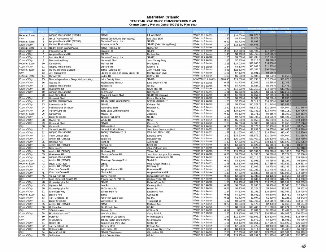
Jurisdiction Priority Rdway From To Improvement Distance 2013 2020 2025 2030 2040Federal/State 1 Apopka-Vineland Rd (SR 535) SR 536 I-4 WB Ramp Widen to 8 Lanes 1.50 $10,600.0 $12,826.0 - - -City 2 SR 15 (Narcoossee Rd) SR 528 (BeachLine Expressway) Lee Vista Blvd Widen to 6 Lanes 1.32 $8,200.0 $9,922.0 - - -Federal/State 3 Apopka-Vineland Rd (SR 535) Osceola County Line SR 536 Widen to 6 Lanes 0.92 $5,700.0 $6,897.0 - - -County/City 4 Central Florida Pkwy International Dr SR 423 (John Young Pkwy) Widen to 6 Lanes 1.94 $12,100.0 $14,641.0 - - -Federal/State 5 (1) SR 423 (John Young Pkwy) SR 50 (Colonial Dr) Shader Rd Widen to 6 Lanes 2.20 0.0 $0.0 - - -County/City 6 International Dr Hawaian Ct SR 482 Widen to 6 Lanes 2.05 $12,800.0 $15,488.0 $17,280.0 - -County/City 7 Apopka-Vineland Rd CR 535 Fenton Ave Widen to 6 Lanes 1.43 $8,900.0 $10,769.0 $12,015.0 - -County/City 8 Landstar Blvd Osceola County Line SR 417 Widen to 6 Lanes 1.53 $9,500.0 $11,495.0 $12,825.0 - -County/City 9 Destination Pkwy Universal Blvd John Young Pkwy Widen to 6 Lanes 1.15 $7,200.0 $8,712.0 $9,720.0 - -Federal/State 10 Conway Rd Hoffner Rd Michigan St Widen to 6 Lanes 2.25 $14,000.0 $16,940.0 $18,900.0 - -County/City 11 Apopka-Vineland Rd Darlene Rd Kilgore Rd Widen to 6 Lanes 1.34 $8,300.0 $10,043.0 $11,205.0 - -Federal/State 12 US 441 (Orange Blossom Tr) SR 50 (Colonial Dr) John Young Pkwy Widen to 6 Lanes 3.63 $22,600.0 $27,346.0 $30,510.0 - -City 13 Jeff Fuqua Blvd .13 miles South of Boggy Creek Rd Heintzelman Blvd Widen to 4 Lanes 1.06 $7,100.0 $8,591.0 $9,585.0 - -Federal/State 14 Conway Rd Judge Rd Hoffner Rd Widen to 6 Lanes 1.00 $6,200.0 $7,502.0 $8,370.0 $9,858.0 -County/City 15 New Independence Pkwy/Wellness Way Lake County Line SR 429 New/Widen 4 Lanes 1.07/0.45 $13,000.0 $15,730.0 $17,550.0 $20,670.0 -County/City 16 Alafaya Tr Huckleberry Finn Dr Lake Underhill Rd Widen to 6 Lanes 0.28 $1,700.0 $2,057.0 $2,295.0 $2,703.0 -County/City 17 Apopka-Vineland Rd Kilgore Rd SR 482 Widen to 6 Lanes 0.75 $4,700.0 $5,687.0 $6,345.0 $7,473.0 -County/City 18 Hiawassee Rd SR 50 Silver Star Rd Widen to 6 Lanes 1.76 $11,000.0 $13,310.0 $14,850.0 $17,490.0 -County/City 19 Apopka-Vineland Rd Fenton Ave Darlene Rd Widen to 6 Lanes 1.01 $6,300.0 $7,623.0 $8,505.0 $10,017.0 -City 20 Lake Nona Blvd Tavistock Lakes Blvd SR 417 (Greenway) Widen to 6 Lanes 0.28 $1,700.0 $2,057.0 $2,295.0 $2,703.0 -County/City 21 Universal Blvd SR 482 Pointe Plaza Ave Widen to 6 Lanes 1.00 $6,200.0 $7,502.0 $8,370.0 $9,858.0 -County/City 22 Central Florida Pkwy SR 423 (John Young Pkwy) Orange Blossom Tr Widen to 6 Lanes 1.23 $7,700.0 $9,317.0 $10,395.0 $12,243.0 -County/City 23 International Dr SR 482 Kirkman Rd Widen to 6 Lanes 1.39 $8,700.0 $10,527.0 $11,745.0 $13,833.0 -County/City 24 International Dr South Westwood Blvd Hawaian Ct Widen to 6 Lanes 2.50 $15,600.0 $18,876.0 $21,060.0 $24,804.0 $31,668.0County/City 25 Turkey Lake Rd Sand Lake Commons Blvd SR 482 Widen to 6 Lanes 1.63 $10,200.0 $12,342.0 $13,770.0 $16,218.0 $20,706.0Federal/State 26 Conway Rd McCoy Rd Judge Rd Widen to 6 Lanes 0.82 $5,100.0 $6,171.0 $6,885.0 $8,109.0 $10,353.0County/City 27 Boggy Creek Rd Beacon Park Blvd SR 417 Widen to 6 Lanes 1.56 $9,700.0 $11,737.0 $13,095.0 $15,423.0 $19,691.0County/City 28 Clarke Rd White Rd SR 50 Widen to 6 Lanes 0.80 $5,000.0 $6,050.0 $6,750.0 $7,950.0 $10,150.0County/City 29 Universal Blvd SR 482 Carrier Dr Widen to 6 Lanes 1.00 $6,200.0 $7,502.0 $8,370.0 $9,858.0 $12,586.0City 30 Conroy Rd Millenia Blvd Eastgate Dr Widen to 6 Lanes 0.29 $1,800.0 $2,178.0 $2,430.0 $2,862.0 $3,654.0County/City 31 Turkey Lake Rd Central Florida Pkwy Sand Lake Commons Blvd Widen to 6 Lanes 1.18 $7,300.0 $8,833.0 $9,855.0 $11,607.0 $14,819.0County/City 32 Apopka-Vineland Rd Conroy-Windermere Rd Westover Roberts Rd Widen to 6 Lanes 1 77 $11 000 0 $13 310 0 $14 850 0 $17 490 0 $22 330 0
Budget Allocation by Year ($000's)
MetroPlan OrlandoYEAR 2040 LONG RANGE TRANSPORTATION PLAN
Orange County Project Costs ($000's) by Plan Year
County/City 32 Apopka Vineland Rd Conroy Windermere Rd Westover Roberts Rd Widen to 6 Lanes 1.77 $11,000.0 $13,310.0 $14,850.0 $17,490.0 $22,330.0County/City 33 Town Center Blvd US 441 Landstar Blvd Widen to 6 Lanes 2.50 $15,600.0 $18,876.0 $21,060.0 $24,804.0 $31,668.0County/City 34 Avalon Rd (CR 545) Seidel Rd McKinney Rd Widen to 4 Lanes 3.88 $26,000.0 $31,460.0 $35,100.0 $41,340.0 $52,780.0County/City 35 Oakland Ave Tubb St Avalon Rd Widen to 4 Lanes 1.12 $7,500.0 $9,075.0 $10,125.0 $11,925.0 $15,225.0County/City 36 Avalon Rd (CR 545) Tilden Rd Marsh Rd Widen to 4 Lanes 0.73 $4,900.0 $5,929.0 $6,615.0 $7,791.0 $9,947.0County/City 37 Deer Isle Dr SR 50 West Oakland Ave Widen to 4 Lanes 0.09 $600.0 $726.0 $810.0 $954.0 $1,218.0County/City 38 Avalon Rd (CR 545) McKinney Rd Tilden Rd Widen to 4 Lanes 2.26 $15,200.0 $18,392.0 $20,520.0 $24,168.0 $30,856.0County/City 39 Hiawassee Rd Clarcona-Ocoee Rd John Land Apopka Expressway Widen to 6 Lanes 0.58 $3,600.0 $4,356.0 $4,860.0 $5,724.0 $7,308.0County/City 40 Apopka-Vineland Rd SR 482 Conroy-Windermere Rd Widen to 6 Lanes 3.15 $19,600.0 $23,716.0 $26,460.0 $31,164.0 $39,788.0County/City 41 Avalon Rd (CR 545) Flamingo Crossings Blvd Seidel Rd Widen to 4 Lanes 0.49 $3,300.0 $3,993.0 $4,455.0 $5,247.0 $6,699.0Federal/State 42 Plant St (SR 438) 9th St West Crown Point Rd Widen to 4 Lanes 1.95 $13,100.0 $15,851.0 $17,685.0 $20,829.0 $26,593.0County/City 43 Avalon Rd (CR 545) US 192 Hartzog Rd Widen to 4 Lanes 0.97 $6,500.0 $7,865.0 $8,775.0 $10,335.0 $13,195.0County/City 44 Clarcona-Ocoee Rd Apopka-Vineland Rd Hiawassee Rd Widen to 6 Lanes 1.37 $8,500.0 $10,285.0 $11,475.0 $13,515.0 $17,255.0County/City 45 Clarcona-Ocoee Rd Clarke Rd Apopka-Vineland Rd Widen to 6 Lanes 1.17 $7,300.0 $8,833.0 $9,855.0 $11,607.0 $14,819.0County/City 46 Young Pine Rd Curry Ford Rd Cypress Springs Pkwy Widen to 4 Lanes 0.35 $2,300.0 $2,783.0 $3,105.0 $3,657.0 $4,669.0City 47 Lake Underhill Rd (CR 15) E Anderson St (CR 15) Gaston Foster Rd Widen to 4 Lanes 1.20 $8,000.0 $9,680.0 $10,800.0 $12,720.0 $16,240.0County/City 48 Ocoee-Apopka Rd SR 438 Fullers Cross Rd Widen to 4 Lanes 1.50 $10,100.0 $12,221.0 $13,635.0 $16,059.0 $20,503.0County/City 49 Wymore Rd Lee Rd Kennedy Blvd Widen to 4 Lanes 0.89 $6,000.0 $7,260.0 $8,100.0 $9,540.0 $12,180.0County/City 50 Ocoee-Apopka Rd McCormick Rd Binion Rd Widen to 4 Lanes 0.65 $4,400.0 $5,324.0 $5,940.0 $6,996.0 $8,932.0County/City 51 Glenridge Way Winter Park Rd Lakemont Ave Widen to 4 Lanes 1.14 $7,600.0 $9,196.0 $10,260.0 $12,084.0 $15,428.0Federal/State 52 Bluford Ave SR 50 Geneva St Widen to 4 Lanes 0.63 $4,200.0 $5,082.0 $5,670.0 $6,678.0 $8,526.0County/City 53 Taft-Vineland Rd American Eagle Way US 441 Widen to 4 Lanes 0.21 $1,400.0 $1,694.0 $1,890.0 $2,226.0 $2,842.0County/City 54 Boggy Creek Rd Wetherbee Rd Tradeport Dr Widen to 4 Lanes 1.32 $8,900.0 $10,769.0 $12,015.0 $14,151.0 $18,067.0County/City 55 Avalon Rd (CR 545) SR 50 Oakland Ave Widen to 4 Lanes 0.27 $1,800.0 $2,178.0 $2,430.0 $2,862.0 $3,654.0County/City 56 Holden Ave Rio Grande Ave US 441 Widen to 4 Lanes 1.28 $8,600.0 $10,406.0 $11,610.0 $13,674.0 $17,458.0City 57 S Division Ave Raleigh St W Gore St Widen to 4 Lanes 0.14 $900.0 $1,089.0 $1,215.0 $1,431.0 $1,827.0County/City 58 Econlockhatchee Tr Lee Vista Blvd Curry Ford Rd Widen to 4 Lanes 2.25 $15,100.0 $18,271.0 $20,385.0 $24,009.0 $30,653.0City 59 Mercy Dr Old Winter Garden Rd W Princeton St Widen to 4 Lanes 1.67 $11,200.0 $13,552.0 $15,120.0 $17,808.0 $22,736.0City 60 W Church St SR 423 (John Young Pkwy) S Tampa Ave Widen to 4 Lanes 0.48 $3,200.0 $3,872.0 $4,320.0 $5,088.0 $6,496.0County/City 61 Reams Rd Summerlake Park Blvd Center Dr Widen to 4 Lanes 1.95 $13,100.0 $15,851.0 $17,685.0 $20,829.0 $26,593.0County/City 62 Taft-Vineland Rd General Blvd Orange Ave Widen to 4 Lanes 1.04 $7,000.0 $8,470.0 $9,450.0 $11,130.0 $14,210.0County/City 63 McKinnon Rd Lake Butler Rd West Lake Butler Blvd Widen to 4 Lanes 0.50 $3,400.0 $4,114.0 $4,590.0 $5,406.0 $6,902.0City 64 Boggy Creek Rd SR 417 (Greenway) Wetherbee Rd Widen to 4 Lanes 2.58 $17,300.0 $20,933.0 $23,355.0 $27,507.0 $35,119.0County/City 65 SadlerAve Lake County Line US 441 Widen to 4 Lanes 2.37 $15,900.0 $19,239.0 $21,465.0 $25,281.0 $32,277.0
49
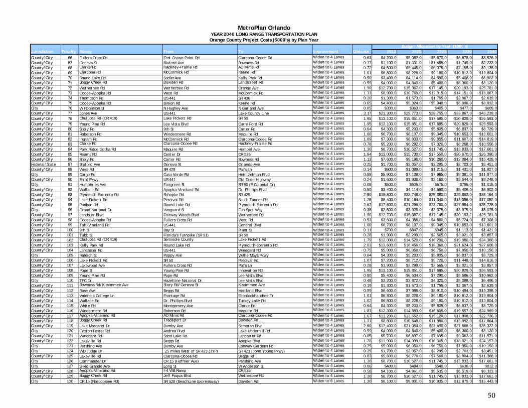
Jurisdiction Priority Rdway From To Improvement Distance 2013 2020 2025 2030 2040Budget Allocation by Year ($000's)
MetroPlan OrlandoYEAR 2040 LONG RANGE TRANSPORTATION PLAN
Orange County Project Costs ($000's) by Plan Year
County/City 66 Fullers Cross Rd East Crown Point Rd Clarcona-Ocoee Rd Widen to 4 Lanes 0.63 $4,200.0 $5,082.0 $5,670.0 $6,678.0 $8,526.0County/City 67 Geneva St Bluford Ave Bowness Rd Widen to 4 Lanes 0.17 $1,100.0 $1,331.0 $1,485.0 $1,749.0 $2,233.0County/City 68 Clarke Rd Hackney-Prairie Rd AD Mims Rd Widen to 6 Lanes 0.72 $4,500.0 $5,445.0 $6,075.0 $7,155.0 $9,135.0County/City 69 Clarcona Rd McCormick Rd Keene Rd Widen to 4 Lanes 1.01 $6,800.0 $8,228.0 $9,180.0 $10,812.0 $13,804.0County/City 70 Round Lake Rd SadlerAve Kelly Park Rd Widen to 4 Lanes 0.50 $3,400.0 $4,114.0 $4,590.0 $5,406.0 $6,902.0County/City 71 Boggy Creek Rd Dowden Rd Landstreet Rd Widen to 4 Lanes 0.59 $4,000.0 $4,840.0 $5,400.0 $6,360.0 $8,120.0County/City 72 Wetherbee Rd Wetherbee Rd Orange Ave Widen to 4 Lanes 1.90 $12,700.0 $15,367.0 $17,145.0 $20,193.0 $25,781.0County/City 73 Ocoee-Apopka Rd West Rd McCormick Rd Widen to 4 Lanes 1.33 $8,900.0 $10,769.0 $12,015.0 $14,151.0 $18,067.0County/City 74 Thompson Rd US 441 SR 436 Widen to 4 Lanes 0.20 $1,300.0 $1,573.0 $1,755.0 $2,067.0 $2,639.0County/City 75 Ocoee-Apopka Rd Binion Rd Keene Rd Widen to 4 Lanes 0.65 $4,400.0 $5,324.0 $5,940.0 $6,996.0 $8,932.0City 76 W Robinson St N Hughey Ave N Garland Ave Widen to 4 Lanes 0.05 $300.0 $363.0 $405.0 $477.0 $609.0County/City 77 Jones Ave US 441 Lake County Line Widen to 4 Lanes 3.17 $21,300.0 $25,773.0 $28,755.0 $33,867.0 $43,239.0County/City 78 Chuluota Rd (CR 419) Lake Pickett Rd SR 50 Widen to 4 Lanes 1.95 $13,100.0 $15,851.0 $17,685.0 $20,829.0 $26,593.0County/City 79 Young Pine Rd Lee Vista Blvd Curry Ford Rd Widen to 4 Lanes 1.95 $13,100.0 $15,851.0 $17,685.0 $20,829.0 $26,593.0County/City 80 Story Rd 9th St Carter Rd Widen to 4 Lanes 0.64 $4,300.0 $5,203.0 $5,805.0 $6,837.0 $8,729.0County/City 81 Roberson Rd Windermere Rd Maguire Rd Widen to 4 Lanes 1.00 $6,700.0 $8,107.0 $9,045.0 $10,653.0 $13,601.0County/City 82 Ingram Rd McCormick Rd Clarcona-Ocoee Rd Widen to 4 Lanes 1.09 $7,300.0 $8,833.0 $9,855.0 $11,607.0 $14,819.0County/City 83 Clarke Rd Clarcona-Ocoee Rd Hackney-Prairie Rd Widen to 4 Lanes 0.78 $5,200.0 $6,292.0 $7,020.0 $8,268.0 $10,556.0County/City 84 Park Ridge Gotha Rd Maguire Rd Hempel Ave Widen to 4 Lanes 1.30 $8,700.0 $10,527.0 $11,745.0 $13,833.0 $17,661.0County/City 85 Reams Rd Center Dr CR 535 Widen to 4 Lanes 1.94 $13,000.0 $15,730.0 $17,550.0 $20,670.0 $26,390.0County/City 86 Story Rd Carter Rd Bowness Rd Widen to 4 Lanes 1.13 $7,600.0 $9,196.0 $10,260.0 $12,084.0 $15,428.0Federal/State 87 Bluford Ave Geneva St Orlando Ave Widen to 4 Lanes 0.25 $1,700.0 $2,057.0 $2,295.0 $2,703.0 $3,451.0County/City 88 West Rd SR 429 Pat's Ln Widen to 4 Lanes 0.14 $900.0 $1,089.0 $1,215.0 $1,431.0 $1,827.0City 89 Cargo Rd Casa Verde Rd Heintzelman Blvd Widen to 4 Lanes 0.88 $5,900.0 $7,139.0 $7,965.0 $9,381.0 $11,977.0County/City 90 Errol Pkwy US 441 Old Dixie Highway Widen to 4 Lanes 0.24 $1,600.0 $1,936.0 $2,160.0 $2,544.0 $3,248.0City 91 Humphries Ave Fairgreen St SR 50 (E Colonial Dr) Widen to 4 Lanes 0.08 $500.0 $605.0 $675.0 $795.0 $1,015.0County/City 92 Wallace Rd Apopka-Vineland Rd Dr. Phillips Blvd Widen to 4 Lanes 0.50 $3,400.0 $4,114.0 $4,590.0 $5,406.0 $6,902.0County/City 93 Plymouth-Sorrento Rd Schopke Rd SR 429 Widen to 4 Lanes 2.80 $18,800.0 $22,748.0 $25,380.0 $29,892.0 $38,164.0County/City 94 Lake Pickett Rd Percival Rd South Tanner Rd Widen to 4 Lanes 1.25 $8,400.0 $10,164.0 $11,340.0 $13,356.0 $17,052.0County/City 95 Ponkan Rd Round Lake Rd Plymouth-Sorrento Rd Widen to 4 Lanes 2.62 $17,600.0 $21,296.0 $23,760.0 $27,984.0 $35,728.0City 96 Grand National Dr Vanguard St Fun Spot Way Widen to 4 Lanes 0.38 $2,500.0 $3,025.0 $3,375.0 $3,975.0 $5,075.0County/City 97 Landstar Blvd Fairway Woods Blvd Wetherbee Rd Widen to 4 Lanes 1 90 $12 700 0 $15 367 0 $17 145 0 $20 193 0 $25 781 0County/City 97 Landstar Blvd Fairway Woods Blvd Wetherbee Rd Widen to 4 Lanes 1.90 $12,700.0 $15,367.0 $17,145.0 $20,193.0 $25,781.0County/City 98 Ocoee-Apopka Rd Fullers Cross Rd West Rd Widen to 4 Lanes 0.53 $3,600.0 $4,356.0 $4,860.0 $5,724.0 $7,308.0County/City 99 Taft-Vineland Rd US 441 General Blvd Widen to 4 Lanes 1.00 $6,700.0 $8,107.0 $9,045.0 $10,653.0 $13,601.0County/City 100 9th St Bay St Plant St Widen to 4 Lanes 0.11 $700.0 $847.0 $945.0 $1,113.0 $1,421.0County/City 101 Tubb St Florida's Turnpike (SR 91) SR 50 Widen to 4 Lanes 0.28 $1,900.0 $2,299.0 $2,565.0 $3,021.0 $3,857.0County/City 102 Chuluota Rd (CR 419) Seminole County Lake Pickett Rd Widen to 4 Lanes 1.79 $12,000.0 $14,520.0 $16,200.0 $19,080.0 $24,360.0County/City 103 Kelly Park Rd Round Lake Rd Plymouth-Sorrento Rd Widen to 4 Lanes 2.03 $13,600.0 $16,456.0 $18,360.0 $21,624.0 $27,608.0County/City 104 Lancaster Rd US 441 Winegard Rd Widen to 4 Lanes 0.75 $5,000.0 $6,050.0 $6,750.0 $7,950.0 $10,150.0City 105 Raleigh St Poppy Ave Willie Mays Pkwy Widen to 4 Lanes 0.64 $4,300.0 $5,203.0 $5,805.0 $6,837.0 $8,729.0County/City 106 Lake Pickett Rd SR 50 Percival Rd Widen to 4 Lanes 1.07 $7,200.0 $8,712.0 $9,720.0 $11,448.0 $14,616.0County/City 107 Lakewood Ave Fullers Cross Rd Pat's Ln Widen to 4 Lanes 0.28 $1,900.0 $2,299.0 $2,565.0 $3,021.0 $3,857.0County/City 108 Pope St Young Pine Rd Innovation Rd Widen to 4 Lanes 1.95 $13,100.0 $15,851.0 $17,685.0 $20,829.0 $26,593.0County/City 109 Young Pine Rd Pope Rd Lee Vista Blvd Widen to 4 Lanes 0.80 $5,400.0 $6,534.0 $7,290.0 $8,586.0 $10,962.0City 110 TPC Dr Hazeltine National Dr Lee Vista Blvd Widen to 4 Lanes 0.48 $3,200.0 $3,872.0 $4,320.0 $5,088.0 $6,496.0County/City 111 Bowness Rd/Kissimmee Ave Story Rd/Geneva St Kissimmee Ave Widen to 4 Lanes 0.19 $1,300.0 $1,573.0 $1,755.0 $2,067.0 $2,639.0County/City 112 Rose Ave Beggs Rd Maitland Blvd Widen to 4 Lanes 0.99 $6,600.0 $7,986.0 $8,910.0 $10,494.0 $13,398.0County/City 113 Valencia College Ln Frontage Rd Econlockhatchee Tr Widen to 4 Lanes 1.01 $6,800.0 $8,228.0 $9,180.0 $10,812.0 $13,804.0County/City 114 Wallace Rd Dr. Phillips Blvd Turkey Lake Rd Widen to 4 Lanes 1.02 $6,800.0 $8,228.0 $9,180.0 $10,812.0 $13,804.0County/City 115 White Rd Montgomery Ave Clarke Rd Widen to 4 Lanes 0.64 $4,300.0 $5,203.0 $5,805.0 $6,837.0 $8,729.0County/City 116 Windermere Rd Roberson Rd Maguire Rd Widen to 4 Lanes 1.83 $12,300.0 $14,883.0 $16,605.0 $19,557.0 $24,969.0County/City 117 Apopka-Vineland Rd AD Mims Rd Clarcona-Ocoee Rd Widen to 4 Lanes 1.67 $11,200.0 $13,552.0 $15,120.0 $17,808.0 $22,736.0County/City 118 Boggy Creek Rd Tradeport Dr Dowden Rd Widen to 4 Lanes 1.31 $8,800.0 $10,648.0 $11,880.0 $13,992.0 $17,864.0County/City 119 Lake Margaret Dr Bumby Ave Semoran Blvd Widen to 4 Lanes 2.60 $17,400.0 $21,054.0 $23,490.0 $27,666.0 $35,322.0City 120 Gaston Foster Rd Andrea Blvd Lake Underhill Rd Widen to 4 Lanes 0.59 $4,000.0 $4,840.0 $5,400.0 $6,360.0 $8,120.0County/City 121 Winegard Rd Sand Lake Rd Lancaster Rd Widen to 4 Lanes 0.85 $5,700.0 $6,897.0 $7,695.0 $9,063.0 $11,571.0County/City 122 Lakeville Rd Beggs Rd Apopka Blvd Widen to 4 Lanes 1.78 $11,900.0 $14,399.0 $16,065.0 $18,921.0 $24,157.0City 123 Pershing Ave Bumby Ave Conway Gardens Rd Widen to 4 Lanes 0.75 $5,000.0 $6,050.0 $6,750.0 $7,950.0 $10,150.0City 124 WD Judge Dr .25 miles West of SR 423 (JYP) SR 423 (John Young Pkwy) Widen to 4 Lanes 0.25 $1,700.0 $2,057.0 $2,295.0 $2,703.0 $3,451.0County/City 125 Lakeville Rd Clarcona-Ocoee Rd Beggs Rd Widen to 4 Lanes 0.83 $5,600.0 $6,776.0 $7,560.0 $8,904.0 $11,368.0City 126 Commander Dr CR 15 (Hoffner Ave) Pershing Ave Widen to 4 Lanes 1.30 $8,700.0 $10,527.0 $11,745.0 $13,833.0 $17,661.0City 127 S Rio Grande Ave Long St W Anderson St Widen to 4 Lanes 0.06 $400.0 $484.0 $540.0 $636.0 $812.0County/City 128 Apopka-Vineland Rd I-4 WB Ramp CR 535 Widen to 8 Lanes 0.58 $4,100.0 $4,961.0 $5,535.0 $6,519.0 $8,323.0County/City 129 Boggy Creek Rd Jeff Fuqua Blvd Wetherbee Rd Widen to 4 Lanes 1.30 $8,700.0 $10,527.0 $11,745.0 $13,833.0 $17,661.0City 130 CR 15 (Narcoossee Rd) SR 528 (BeachLine Expressway) Dowden Rd Widen to 6 Lanes 1.30 $8,100.0 $9,801.0 $10,935.0 $12,879.0 $16,443.0
50
Jurisdiction Priority Rdway From To Improvement Distance 2013 2020 2025 2030 2040Budget Allocation by Year ($000's)
MetroPlan OrlandoYEAR 2040 LONG RANGE TRANSPORTATION PLAN
Orange County Project Costs ($000's) by Plan Year
County/City 131 CR 535 Apopka-Vineland Rd Buena Vista Dr Widen to 4 Lanes 1.88 $12,600.0 $15,246.0 $17,010.0 $20,034.0 $25,578.0County/City 132 CR 535 Buena Vista Dr Equestrian Dr Widen to 6 Lanes 1.17 $7,300.0 $8,833.0 $9,855.0 $11,607.0 $14,819.0Federal/State 133 Curry Ford Rd SR 436 Goldenrod Rd Widen to 6 Lanes 1.40 $8,700.0 $10,527.0 $11,745.0 $13,833.0 $17,661.0County/City 134 Curry Ford Rd Goldenrod Rd Dean Rd Widen to 6 Lanes 3.10 $19,300.0 $23,353.0 $26,055.0 $30,687.0 $39,179.0County/City 135 Dean Rd University Blvd McCulloch Rd Widen to 4 Lanes 1.02 $19,000.0 $22,990.0 $25,650.0 $30,210.0 $38,570.0City 136 Goldenrod Rd Lee Vista Blvd .29 miles North of Lee Vista Blvd Widen to 6 Lanes 0.29 $1,800.0 $2,178.0 $2,430.0 $2,862.0 $3,654.0County/City 137 John Young Pkwy Osceola County Line Town Center Blvd Widen to 8 Lanes 1.77 $12,500.0 $15,125.0 $16,875.0 $19,875.0 $25,375.0County/City 138 John Young Pkwy Town Center Blvd Deerfield Blvd Widen to 8 Lanes 0.64 $4,500.0 $5,445.0 $6,075.0 $7,155.0 $9,135.0County/City 139 John Young Pkwy Central Florida Pkwy Interstate 4 Widen to 8 Lanes 7.30 $51,500.0 $62,315.0 $69,525.0 $81,885.0 $104,545.0County/City 140 John Young Pkwy Interstate 4 SR 50 Widen to 8 Lanes 3.20 $22,600.0 $27,346.0 $30,510.0 $35,934.0 $45,878.0County/City 141 Kennedy Blvd Forest City Rd Keller Rd Widen to 4 Lanes 1.02 $6,800.0 $8,228.0 $9,180.0 $10,812.0 $13,804.0County/City 142 Kennedy Blvd Keller Rd Wymore Rd Widen to 4 Lanes 0.74 $5,000.0 $6,050.0 $6,750.0 $7,950.0 $10,150.0City 143 Lake Margaret Dr Bumby Ave Semoran Blvd Widen to 4 Lanes 2.60 $17,400.0 $21,054.0 $23,490.0 $27,666.0 $35,322.0County/City 144 North-South Rd Osceola County Line Wewahootee Rd New 4 Lane 5.30 $50,000.0 $60,500.0 $67,500.0 $79,500.0 $101,500.0County/City 145 Nova Rd (CR 532) Osceola County Line SR 520 Widen to 4 Lanes 2.63 $17,600.0 $21,296.0 $23,760.0 $27,984.0 $35,728.0County/City 146 Orange Ave Osceola County Line Town Center Blvd Widen to 4 Lanes 1.22 $8,200.0 $9,922.0 $11,070.0 $13,038.0 $16,646.0County/City 147 Orange Ave Taft-Vineland Rd Landstreet Rd Widen to 6 Lanes 1.08 $6,700.0 $8,107.0 $9,045.0 $10,653.0 $13,601.0County/City 148 Orange Ave Landstreet Rd SR 482 Widen to 6 Lanes 1.06 $6,600.0 $7,986.0 $8,910.0 $10,494.0 $13,398.0County/City 149 Palm Pkwy/Turkey Lake Rd SR 535 Central Florida Pkwy Widen to 6 Lanes 2.66 $16,600.0 $20,086.0 $22,410.0 $26,394.0 $33,698.0County/City 150 Sand Lake Rd Apopka-Vineland Rd Turkey Lake Rd Widen to 6 Lanes 1.33 $8,300.0 $10,043.0 $11,205.0 $13,197.0 $16,849.0City 151 Silver Star Rd Mercy Dr SR 441 (Orange Blossom Tr) Widen to 4 Lanes 1.33 $8,900.0 $10,769.0 $12,015.0 $14,151.0 $18,067.0City 152 Tradeport Dr Earhart Dr SR 528 (BeachLine Expressway) Widen to 6 Lanes 1.05 $6,500.0 $7,865.0 $8,775.0 $10,335.0 $13,195.0County/City 153 West Lake Butler Rd Winter Garden-Vineland Rd McKinnon Rd Widen to 4 Lanes 0.50 $3,400.0 $4,114.0 $4,590.0 $5,406.0 $6,902.0(1) Refer to Priority Project List
Inflation Rates 1.21 1.35 1.59 2.03
Budget $47,500.0 $119,500.0 $120,400.0 $243,700.0Budget + Carry Forward $47,500.0 $122,714.0 $121,074.0 $257,926.0Project Cost $44,286.0 $122,040.0 $106,848.0 $256,795.0Remaining Budget $3,214.0 $674.0 $14,226.0 $1,131.0
Total Cost of Completion in 2040$2 667 217 0$2,667,217.0Total Project Cost in YOE$529,969.0
2019-2020 2021-2025 2026-2030 2031-2040Constitutional Gas Tax $17,500.0 $44,500.0 $45,400.0 $93,700.0Traffic Impact Fees $30,000.0 $75,000.0 $75,000.0 $150,000.0General Fund $89,700.0 $266,800.0 $309,000.0 $770,600.0
LYNX -$89,700.0 -$248,780.0 -$288,430.0 -$721,810.0SunRail $0.0 -$18,020.0 -$20,570.0 -$48,790.0
Total Funding for Highway Projects $47,500.0 $119,500.0 $120,400.0 $243,700.0
Budget BreakdownOrange County
51
Jurisdiction Priority Roadway From To Improvement Distance 2013 2020 2025 2030 2040County/City 1 Oak St Central Ave US 192 Widen to 4 Lanes 1.19 $12,167.5 $14,722.7 - - -County/City 2 Neptune Rd Old Canoe Creek Rd US 192 Widen to 4 Lanes 0.48 $3,200.0 $3,872.0 - - -County/City 3 (1) Hoagland Blvd 500' W of Pleasant Hill Blvd John Young Pkwy Widen to 6 Lanes 0.81 $0.0 $0.0 - - -County/City 4 CR 530 (Simpson Rd) Osceola Pkwy Boggy Creek E/Orange Co Line Widen to 4 Lanes 1.09 $7,300.0 $8,833.0 - - -County/City 5 (1) Hoagland Blvd 5th St 500' W of Pleasant Hill Blvd Widen to 4 Lanes 1.76 $0.0 $0.0 - - -County/City 6 Canoe Creek Rd (CR 523) 17th St US 192 Widen to 4 Lanes 0.24 $1,600.0 $1,936.0 - - -County/City 7 Neptune Rd Partin Settlement Rd Henry Partin Rd Widen to 4 Lanes 1.19 $8,000.0 $9,680.0 - - -County/City 7 Neptune Rd Henry Partin Rd Old Canoe Creek Rd Widen to 4 Lanes 2.26 $15,200.0 $18,392.0 - - -County/City 8 CR 530 (Simpson Rd) Buenaventura Blvd Osceola Pkwy Widen to 6 Lanes 1.48 $9,200.0 $11,132.0 - - -County/City 9 Old Canoe Creek Rd Canoe Creek Rd (CR 523) Kissimmee Park Rd Widen to 4 Lanes 2.85 $19,100.0 $23,111.0 - - -County/City 10 Poinciana Blvd Old Tampa Hwy Oren Brown Rd Widen to 4 Lanes 3.59 $24,100.0 $29,161.0 - - -County/City 11 Central Ave US 192 Donegan Ave Widen to 4 Lanes 1.00 $7,500.0 $9,075.0 - - -County/City 12 Orange Ave Osceola Pkwy Orange Co. Line Widen to 4 Lanes 0.53 $3,600.0 $4,356.0 - - -County/City 13 Westside Blvd Bella Citta Blvd. Florence Villa Grove Rd Widen to 4 Lanes 3.00 $22,500.0 $27,225.0 - - -County/City 14 Carroll St Columbia Ave John Young Pkwy Widen to 4 Lanes 2.10 $14,100.0 $17,061.0 $19,035.0 - -County/City 14 Carroll St John Young Pkwy US 441 (Orange Blossom Tr) Widen to 4 Lanes 0.75 $5,000.0 $6,050.0 $6,750.0 - -County/City 14 Carroll St US 441 (Orange Blossom Tr) Old Dixie Hwy Widen to 4 Lanes 0.27 $1,800.0 $2,178.0 $2,430.0 - -County/City 14 Carroll St Old Dixie Hwy Michigan Ave Widen to 4 Lanes 0.49 $3,300.0 $3,993.0 $4,455.0 - -County/City 15 Dyer Blvd Donegan Ave Carroll St Widen to 4 Lanes 0.42 $3,150.0 $3,811.5 $4,252.5 - -County/City 15 Dyer Blvd Carroll St Osceola Pkwy Widen to 6 Lanes 1.25 $7,800.0 $9,438.0 $10,530.0 - -County/City 16 Bill Beck Blvd Boggy Creek Rd Orange Ave Widen to 2 Lanes 2.73 $20,475.0 $24,774.8 $27,641.3 - -County/City 17 Michigan Ave Mill Slough Rd Carroll St Widen to 6 Lanes 0.70 $4,400.0 $5,324.0 $5,940.0 - -County/City 17 Michigan Ave Carroll St Mill Run Blvd Widen to 4 Lanes 0.80 $6,000.0 $7,260.0 $8,100.0 - -County/City 18 Reaves Rd/Mac Overstreet Rd Pleasant Hill Rd Lake Toho Widen to 4 Lanes 0.90 $6,750.0 $8,167.5 $9,112.5 - -County/City 19 Shady Lane Partin Settlement Rd US 192 Widen to 4 Lanes 0.56 $4,200.0 $5,082.0 $5,670.0 - -County/City 20 Sinclair Rd Tradition Blvd Bella Citta Blvd Widen to 4 Lanes 1.50 $11,250.0 $13,612.5 $15,187.5 - -County/City 21 Dyer Blvd Martin Luther King Jr. Blvd US 192/Vine St Widen to 4 Lanes 0.24 $2,725.0 $3,297.3 $3,678.8 - -County/City 22 Old Pleasant Hill Rd Amiens Way Old Pleasant Hill Rd Widen to 4 Lanes 0.42 $3,150.0 $3,811.5 $4,252.5 - -County/City 23 Poinciana Blvd Pleasant Hill Rd Crescent Lakes Way Widen to 4 Lanes 5.69 $38,200.0 $46,222.0 $51,570.0 - -County/City 24 Donegan Ave John Young Pkwy US 441 (Orange Blossom Tr) Widen to 6 Lanes 0.75 $4,700.0 $5,687.0 $6,345.0 - -County/City 24 Donegan Ave US 441 (Orange Blossom Tr) Michigan Ave Widen to 4 Lanes 0.76 $5,100.0 $6,171.0 $6,885.0 - -County/City 25 Buenaventura Blvd Osceola Parkway Florida Pkwy Widen to 6 Lanes 1.42 $8,800.0 $10,648.0 $11,880.0 - -
Budget Allocation by Year ($000's)
MetroPlan OrlandoYEAR 2040 LONG RANGE TRANSPORTATION PLAN
Osceola County Project Costs ($000's) by Plan Year
Cou ty C ty 5 Buenaventura Blvd Osceola Parkway Florida Pkwy Widen to 6 Lanes . $8,800.0 $ 0,6 8.0 $ ,880.0County/City 26 CR 545 (Old Lake Wilson Rd) Sinclair Rd CR 532 (Osceola-Polk Line Rd) Widen to 4 Lanes 2.49 $16,700.0 $20,207.0 $22,545.0 - -County/City 26 Martin Luther King Jr. Blvd Thacker Ave John Young Pkwy Widen to 4 Lanes 0.50 $3,750.0 $4,537.5 $5,062.5 - -County/City 27 Thacker Ave Flora Blvd Osceola Pkwy Widen to 4 Lanes 0.77 $5,775.0 $6,987.8 $7,796.3 - -County/City 28 Hoagland Blvd Columbia Ave US 192 Widen to 4 Lanes 0.24 $2,500.0 $3,025.0 $3,375.0 - -County/City 29 Hickory Tree Rd (CR 534) US 192 Deer Run Rd Widen to 4 Lanes 4.43 $29,700.0 $35,937.0 $40,095.0 - -County/City 30 Old Vineland Rd US 192 US 192 Widen to 4 Lanes 1.36 $9,100.0 $11,011.0 $12,285.0 - -County/City 31 Hickory Tree Rd (CR 534) Deer Run Rd US 192 Widen to 4 Lanes 6.64 $44,500.0 $53,845.0 $60,075.0 - -County/City 32 Reaves Rd Poinciana Blvd Ham Brown Rd Widen to 4 Lanes 0.11 $700.0 $847.0 $945.0 - -County/City 33 Reaves Rd Ham Brown Rd Pleasant Hill Rd Widen to 4 Lanes 1.75 $11,700.0 $14,157.0 $15,795.0 - -County/City 34 Reaves Rd Marigold Ave Poinciana Blvd Widen to 4 Lanes 1.54 $11,550.0 $13,975.5 $15,592.5 - -County/City 35 Woodcrest Blvd Michigan Ave Bill Beck Blvd Widen to 4 Lanes 0.53 $3,975.0 $4,809.8 $5,366.3 - -County/City 36 Martin Luther King Jr. Blvd Dyer Blvd Thacker Ave Widen to 4 Lanes 0.76 $5,700.0 $6,897.0 $7,695.0 - -County/City 37 8th Ave Pine Tree Dr Deer Run Rd Widen to 4 Lanes 0.70 $4,700.0 $5,687.0 $6,345.0 - -County/City 38 Buenaventura Blvd Florida Pkwy Simpson Rd Widen to 6 Lanes 2.27 $14,100.0 $17,061.0 $19,035.0 - -County/City 39 Canoe Creek Rd (CR 523) Lake Cypress Rd Deer Run Rd Widen to 4 Lanes 6.88 $46,100.0 $55,781.0 $62,235.0 - -County/City 40 Canoe Creek Rd (CR 523) Deer Run Rd Old Canoe Creek Rd (CR 523) Widen to 4 Lanes 1.35 $9,100.0 $11,011.0 $12,285.0 - -County/City 41 Canoe Creek Rd (CR 523) Old Canoe Creek Rd Nolte Rd Widen to 4 Lanes 1.80 $12,100.0 $14,641.0 $16,335.0 - -County/City 42 Canoe Creek Rd (CR 523) Nolte Rd 17th St Widen to 4 Lanes 1.27 $8,500.0 $10,285.0 $11,475.0 - -County/City 44 Champions Gate Blvd Polk County Line Interstate 4 Widen to 6 Lanes 0.69 $4,300.0 $5,203.0 $5,805.0 - -County/City 45 Country Club Rd Polk County Line Doverplum Ave Widen to 4 Lanes 0.88 $5,900.0 $7,139.0 $7,965.0 - -County/City 46 CR 530 (Boggy Creek Rd) Boggy Creek E/Orange Co Line Narcoossee Rd Widen to 4 Lanes 5.33 $35,800.0 $43,318.0 $48,330.0 - -County/City 48 CR 530 (Fortune Rd) US 192 Simpson Rd Widen to 6 Lanes 1.24 $7,700.0 $9,317.0 $10,395.0 $12,243.0 -County/City 49 CR 530 (Simpson Rd) Fortune Rd Buenaventura Blvd Widen to 6 Lanes 1.27 $7,900.0 $9,559.0 $10,665.0 $12,561.0 -County/City 50 CR 532 (Osceola-Polk Line Rd) Interstate 4 Old Lake Wilson Rd (CR 545) Widen to 6 Lanes 1.88 $11,700.0 $14,157.0 $15,795.0 $18,603.0 -County/City 51 CR 532 (Osceola-Polk Line Rd) Old Lake Wilson Rd (CR 545) US 17-92 Widen to 4 Lanes 3.02 $20,300.0 $24,563.0 $27,405.0 $32,277.0 -County/City 52 CR 545 (Old Lake Wilson Rd) Westgate Blvd Sinclair Rd Widen to 6 Lanes 2.28 $14,200.0 $17,182.0 $19,170.0 $22,578.0 -County/City 53 Cypress Pkwy (CR 580) Marigold Ave Doverplum Ave Widen to 6 Lanes 1.12 $7,000.0 $8,470.0 $9,450.0 $11,130.0 -County/City 54 Cypress Pkwy (CR 580) Doverplum Ave Old Pleasant Hill Rd Widen to 6 Lanes 0.56 $3,500.0 $4,235.0 $4,725.0 $5,565.0 -County/City 55 (2) Deer Run Rd Canoe Creek Rd (CR 523) Hickory Tree Rd Widen to 4 Lanes 2.42 $16,200.0 $19,602.0 $21,870.0 $25,758.0 -County/City 56 Donegan Ave Thacker Ave John Young Pkwy Widen to 4 Lanes 0.51 $3,400.0 $4,114.0 $4,590.0 $5,406.0 -County/City 57 Doverplum Ave Koa St Cypress Pkwy Widen to 4 Lanes 0.72 $4,800.0 $5,808.0 $6,480.0 $7,632.0 -County/City 58 Doverplum Ave Cypress Pkwy Old Pleasant Hill Rd Widen to 4 Lanes 0.59 $4,000.0 $4,840.0 $5,400.0 $6,360.0 -County/City 59 Dyer Blvd US 192/Vine St Donegan Ave Widen to 4 Lanes 0.76 $5,100.0 $6,171.0 $6,885.0 $8,109.0 -
52
Jurisdiction Priority Roadway From To Improvement Distance 2013 2020 2025 2030 2040Budget Allocation by Year ($000's)
MetroPlan OrlandoYEAR 2040 LONG RANGE TRANSPORTATION PLAN
Osceola County Project Costs ($000's) by Plan Year
County/City 60 Entry Point Blvd Funie Steed Rd US 192 Widen to 4 Lanes 0.21 $1,400.0 $1,694.0 $1,890.0 $2,226.0 -County/City 61 Fanny Bass Pond Rd Toho Parkway Friar's Cove Road Widen to 4 Lanes 1.68 $12,600.0 $15,246.0 $17,010.0 $20,034.0 -County/City 62 Fortune Rd Simpson Rd Lakeshore Blvd E Widen to 4 Lanes 1.69 $11,300.0 $13,673.0 $15,255.0 $17,967.0 -County/City 63 Fria's Cove Rd 0.85 mi west of Florida's Turnpike Deer Run Rd/Canoe Creek Rd Widen to 4 Lanes 0.35 $2,300.0 $2,783.0 $3,105.0 $3,657.0 -County/City 64 Funie Steed Rd Westside Blvd Entry Point Blvd Widen to 4 Lanes 0.88 $5,900.0 $7,139.0 $7,965.0 $9,381.0 -County/City 65 Funie Steed Rd Entry Point Blvd Old Lake Wilson Rd (CR 545) Widen to 4 Lanes 0.32 $2,100.0 $2,541.0 $2,835.0 $3,339.0 -County/City 66 Garden St Old Dixie Hwy Michigan Ave Widen to 4 Lanes 0.42 $2,800.0 $3,388.0 $3,780.0 $4,452.0 -County/City 67 Ham Brown Rd Reaves Rd Old Tampa Hwy Widen to 4 Lanes 4.52 $30,300.0 $36,663.0 $40,905.0 $48,177.0 -County/City 68 Happy Trails Goodman Rd Sinclair Rd Widen to 4 Lanes 1.56 $10,500.0 $12,705.0 $14,175.0 $16,695.0 -County/City 69 Keystone Ave Cecil Whaley Road Clay Whaley Road Widen to 4 Lanes 2.90 $21,750.0 $26,317.5 $29,362.5 $34,582.5 -County/City 70 Kissimmee Park Road Clay Whaley Rd Old Canoe Creek Rd Widen to 4 Lanes 0.32 $2,100.0 $2,541.0 $2,835.0 $3,339.0 -County/City 71 Koa St Rhododendron Ave Poinciana Blvd Widen to 4 Lanes 1.96 $13,100.0 $15,851.0 $17,685.0 $20,829.0 -County/City 72 Lakeshore Blvd Partin Settlement Rd Mississippi Ave Widen to 4 Lanes 3.94 $26,400.0 $31,944.0 $35,640.0 $41,976.0 -County/City 73 Lakeshore Blvd Fortune Rd Remington Blvd Widen to 4 Lanes 0.96 $6,400.0 $7,744.0 $8,640.0 $10,176.0 -County/City 74 Lakeshore Blvd Remington Blvd Partin Settlement Rd Widen to 4 Lanes 0.79 $5,300.0 $6,413.0 $7,155.0 $8,427.0 -County/City 75 Lakeview Parkway Southport Connector Southlake Blvd Widen to 4 Lanes 0.74 $5,550.0 $6,715.5 $7,492.5 $8,824.5 -County/City 76 Landstar Blvd Orange County Line Osceola Parkway Widen to 6 Lanes 0.22 $1,400.0 $1,694.0 $1,890.0 $2,226.0 -County/City 77 Laurel Road Bridge San Lorenzo Road Poinciana Blvd Widen to 4 Lanes 1.57 $11,775.0 $14,247.8 $15,896.3 $18,722.3 -County/City 78 Marigold Ave Bourne Rd Cypress Pkwy Widen to 4 Lanes 2.21 $14,800.0 $17,908.0 $19,980.0 $23,532.0 -County/City 79 Michigan Ave Mill Run Blvd Osceola Pkwy Widen to 6 Lanes 0.29 $1,800.0 $2,178.0 $2,430.0 $2,862.0 -County/City 80 Michigan Ave (St. Cloud) US 192 Creek Woods Dr Widen to 4 Lanes 2.29 $15,400.0 $18,634.0 $20,790.0 $24,486.0 -County/City 81 Mill Slough Rd Michigan Ave Bill Beck Blvd. Widen to 4 Lanes 0.74 $5,000.0 $6,050.0 $6,750.0 $7,950.0 -County/City 82 Narcoossee Rd US 192 Orange County Line Widen to 6 Lanes 7.38 $46,000.0 $55,660.0 $62,100.0 $73,140.0 -County/City 83 Nolte Rd Hickory Tree Rd Nova Rd (CR 532) Widen to 4 Lanes 2.52 $18,900.0 $22,869.0 $25,515.0 $30,051.0 -County/City 84 Nova Rd (CR 532) US 192 Pine Grove Rd Widen to 4 Lanes 2.53 $17,000.0 $20,570.0 $22,950.0 $27,030.0 -County/City 85 Nova Rd (CR 532) Pine Grove Rd Eden Dr Widen to 4 Lanes 0.83 $5,600.0 $6,776.0 $7,560.0 $8,904.0 -County/City 86 Nova Rd (CR 532) Eden Dr Deer Park Rd Widen to 4 Lanes 15.92 $106,800.0 $129,228.0 $144,180.0 $169,812.0 -County/City 87 Nova Rd (CR 532) Deer Park Rd Orange County Line Widen to 4 Lanes 4.54 $30,500.0 $36,905.0 $41,175.0 $48,495.0 $61,915.0County/City 88 Nova Road Alligator Lake Road US 192 Widen to 4 Lanes 2.54 $19,050.0 $23,050.5 $25,717.5 $30,289.5 $38,671.5County/City 89 Old Canoe Creek Rd Kissimmee Park Rd Neptune Rd Widen to 6 Lanes 1.86 $11,600.0 $14,036.0 $15,660.0 $18,444.0 $23,548.0County/City 90 Old Canoe Creek Rd Neptune Rd US 192 Widen to 6 Lanes 0.29 $1,800.0 $2,178.0 $2,430.0 $2,862.0 $3,654.0County/City 91 Old Dixie Hwy Donegan Ave Osceola Pkwy Widen to 4 Lanes 1 33 $8 900 0 $10 769 0 $12 015 0 $14 151 0 $18 067 0County/City 91 Old Dixie Hwy Donegan Ave Osceola Pkwy Widen to 4 Lanes 1.33 $8,900.0 $10,769.0 $12,015.0 $14,151.0 $18,067.0County/City 92 Old Hickory Tree Rd US 192 Nolte Rd Widen to 4 Lanes 1.50 $10,100.0 $12,221.0 $13,635.0 $16,059.0 $20,503.0County/City 93 Old Tampa Hwy US 17/92 Poinciana Blvd Widen to 4 Lanes 3.00 $20,100.0 $24,321.0 $27,135.0 $31,959.0 $40,803.0County/City 94 Old Tampa Hwy Poinciana Blvd Pleasant Hill Rd Widen to 4 Lanes 3.31 $22,200.0 $26,862.0 $29,970.0 $35,298.0 $45,066.0County/City 95 Oren Brown Rd Poinciana Blvd US 192 Widen to 4 Lanes 0.90 $6,000.0 $7,260.0 $8,100.0 $9,540.0 $12,180.0County/City 96 Oren Brown Ext US 192 Poinciana Blvd Widen to 4 Lanes 3.10 $23,250.0 $28,132.5 $31,387.5 $36,967.5 $47,197.5County/City 97 Osceola Pkwy Interstate 4 SR 417 (Greeneway) Widen to 8 Lanes 0.78 $5,500.0 $6,655.0 $7,425.0 $8,745.0 $11,165.0County/City 98 Osceola Pkwy John Young Pkwy US 441 (Orange Blossom Tr) Widen to 6 Lanes 1.08 $6,700.0 $8,107.0 $9,045.0 $10,653.0 $13,601.0County/City 99 Osceola Pkwy Buenaventura Blvd Boggy Creek Rd Widen to 6 Lanes 2.21 $13,800.0 $16,698.0 $18,630.0 $21,942.0 $28,014.0County/City 100 Partin Settlement Rd Neptune Rd US 192 Widen to 4 Lanes 1.16 $7,800.0 $9,438.0 $10,530.0 $12,402.0 $15,834.0County/City 101 Partin Settlement Rd US 192 Lakeshore Blvd Widen to 4 Lanes 0.79 $5,300.0 $6,413.0 $7,155.0 $8,427.0 $10,759.0County/City 102 Pine Tree Dr Canoe Creek Rd Hickory Tree Rd Widen to 4 Lanes 2.00 $13,400.0 $16,214.0 $18,090.0 $21,306.0 $27,202.0County/City 103 Pleasant Hill Rd Poinciana Blvd Reaves Rd Widen to 6 Lanes 3.00 $18,700.0 $22,627.0 $25,245.0 $29,733.0 $37,961.0County/City 104 Pleasant Hill Rd Reaves Rd US 17-92 Widen to 6 Lanes 4.38 $27,300.0 $33,033.0 $36,855.0 $43,407.0 $55,419.0County/City 105 Princess Way Seven Dwarfs Ln Old Vineland Rd Widen to 4 Lanes 0.69 $4,600.0 $5,566.0 $6,210.0 $7,314.0 $9,338.0County/City 106 Quail Roost Rd Rambler Ave Canoe Creek Rd (CR 523) Widen to 4 Lanes 1.27 $8,500.0 $10,285.0 $11,475.0 $13,515.0 $17,255.0County/City 107 Rhododendron Ave Polk County Line Koa St Widen to 4 Lanes 0.83 $5,600.0 $6,776.0 $7,560.0 $8,904.0 $11,368.0County/City 108 Rummell Rd Narcoossee Rd Mississippi Ave Widen to 4 Lanes 1.60 $10,700.0 $12,947.0 $14,445.0 $17,013.0 $21,721.0County/City 109 Rummell Rd Mississippi Ave Nova Road Widen to 4 Lanes 1.01 $7,575.0 $9,165.8 $10,226.3 $12,044.3 $15,377.3County/City 110 Seven Dwarfs Ln US 192 Princess Way Widen to 4 Lanes 0.48 $3,200.0 $3,872.0 $4,320.0 $5,088.0 $6,496.0County/City 111 Sherberth Rd US 192 Orange County Line Widen to 4 Lanes 0.71 $4,800.0 $5,808.0 $6,480.0 $7,632.0 $9,744.0County/City 112 Simpson Rd Fortune Rd US 192 Widen to 4 Lanes 0.73 $4,900.0 $5,929.0 $6,615.0 $7,791.0 $9,947.0County/City 113 Southport Rd Pleasant Hill Rd Hunt Rd Widen to 4 Lanes 1.84 $12,300.0 $14,883.0 $16,605.0 $19,557.0 $24,969.0County/City 114 Stewart Ave Broadway Mabbette St Widen to 4 Lanes 0.12 $800.0 $968.0 $1,080.0 $1,272.0 $1,624.0County/City 115 Tenque Ave Orange County Line Nova Road Widen to 4 Lanes 5.10 $38,250.0 $46,282.5 $51,637.5 $60,817.5 $77,647.5County/City 116 Thacker Ave Donegan Ave Flora Blvd Widen to 6 Lanes 0.35 $2,200.0 $2,662.0 $2,970.0 $3,498.0 $4,466.0County/City 117 Toho Parkway US 192 Southport Connector Widen to 4 Lanes 8.23 $61,725.0 $74,687.3 $83,328.8 $98,142.8 $125,301.8Federal/State Vineland Rd (SR 535) US 192 Orange County Line Widen to 6 Lanes 1.06 $6,600.0 $7,986.0 $8,910.0 $10,494.0 $13,398.0Federal/State SR 60 Polk Co. Line US 441 Widen to 4 Lanes 19.68 $132,000.0 $159,720.0 $178,200.0 $209,880.0 $267,960.0Federal/State SR 60 US 441 SR 91 (Florida's Turnpike) Widen to 6 Lanes 0.40 $2,500.0 $3,025.0 $3,375.0 $3,975.0 $5,075.0Federal/State US 17-92 Polk County Line CR 532 (Osceola-Polk Line Rd) Widen to 4 Lanes 0.94 $6,300.0 $7,623.0 $8,505.0 $10,017.0 $12,789.0Federal/State US 17-92 CR 532 (Osceola-Polk Line Rd) Old Tampa Hwy Widen to 4 Lanes 0.67 $4,500.0 $5,445.0 $6,075.0 $7,155.0 $9,135.0Federal/State US 17-92 Old Tampa Hwy Poinciana Blvd Widen to 4 Lanes 2.86 $19,200.0 $23,232.0 $25,920.0 $30,528.0 $38,976.0Federal/State US 17-92 Poinciana Blvd Ham Brown Rd Widen to 4 Lanes 1.47 $9,900.0 $11,979.0 $13,365.0 $15,741.0 $20,097.0
53
Jurisdiction Priority Roadway From To Improvement Distance 2013 2020 2025 2030 2040Budget Allocation by Year ($000's)
MetroPlan OrlandoYEAR 2040 LONG RANGE TRANSPORTATION PLAN
Osceola County Project Costs ($000's) by Plan Year
Federal/State US 17-92 Ham Brown Rd Pleasant Hill Rd Widen to 6 Lanes 1.65 $10,300.0 $12,463.0 $13,905.0 $16,377.0 $20,909.0Federal/State (1) US 17/92 Pleasant Hill Rd Portage St Widen to 6 Lanes 2.20 $0.0 $0.0 $0.0 $0.0 $0.0Federal/State US 17/92 John Young Pkwy Portage St US 192/Vine St Widen to 6 Lanes 1.11 $6,900.0 $8,349.0 $9,315.0 $10,971.0 $14,007.0Federal/State US 192 Nova Rd (CR 532) Pine Grove Rd Widen to 6 Lanes 1.29 $8,000.0 $9,680.0 $10,800.0 $12,720.0 $16,240.0Federal/State US 441 W Columbia Ave Carroll St CSS Improvements 1.20 $900.0 $1,089.0 $1,215.0 $1,431.0 $1,827.0Federal/State US 441 US 192 W Columbia Ave CSS Improvements 0.29 $217.5 $263.2 $293.6 $345.8 $441.5Federal/State US 441 Carroll St Osceola Pkwy CSS Improvements 0.76 $570.0 $689.7 $769.5 $906.3 $1,157.1Federal/State US 441 Osceola Pkwy Orange Co. Line CSS Improvements 0.71 $532.5 $644.3 $718.9 $846.7 $1,081.0(1) Refer to Priority Project List. (2) Hunting Lodge Rd from Turnpike/Canoe Creek Rd to Hickory Tree Rd, may be done instead.
Inflation Rates 1.21 1.35 1.59 2.03
Year of Expenditure (YOE) Total Cost $1,706,262.5 $2,064,577.6 $2,123,273.3 $1,805,675.6 $1,269,907.1Budget $177,169.0 $582,300.0 $829,200.0 $2,559,300.0Budget + Carry Forward $177,169.0 $597,973.3 $837,020.8 $2,588,958.6Project Cost $161,495.7 $590,152.5 $807,362.3 $1,269,907.1Remaining Budget $15,673.3 $7,820.8 $29,658.6 $1,319,051.5
Total Cost of Completion in 2040$3,463,712.9Total Project Cost in YOE$2,828,917.5
2019-2020 2021-2025 2026-2030 2031-2040Infrastructure Sales Tax $21,500.0 $62,800.0 $100,500.0 $251,400.0Charter County Transportation Surtax $97,800.0 $301,600.0 $341,400.0 $865,400.0Existing Growth Designated Ad Valorem Tax $6,600.0 $35,300.0 $67,000.0 $259,800.0New Growth Designated Ad Valorem Tax $21,900.0 $113,800.0 $241,300.0 $966,100.0General Fund $47,900.0 $136,900.0 $165,400.0 $444,300.0LYNX -$18,531.0 -$58,430.0 -$75,805.0 -$203,735.0SunRail $0.0 -$9,670.0 -$10,595.0 -$23,965.0
T l F di f Hi h P j $177 169 0 $582 300 0 $829 200 0 $2 559 300 0
Budget BreakdownOsceola County
Total Funding for Highway Projects $177,169.0 $582,300.0 $829,200.0 $2,559,300.0
54
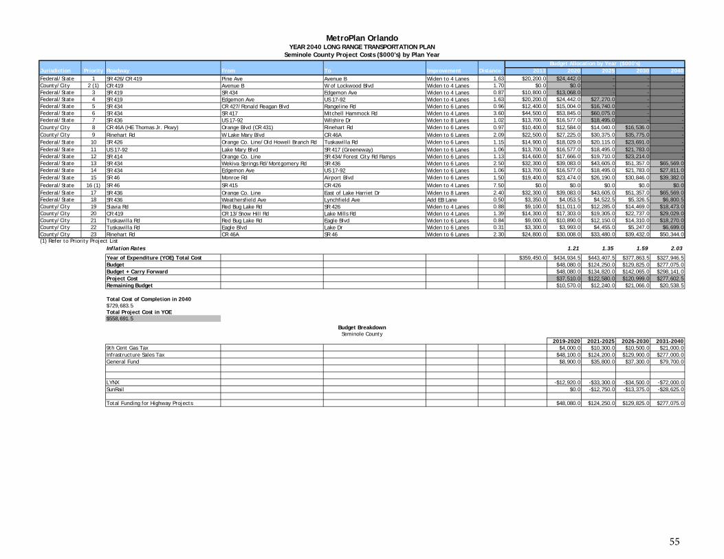
Jurisdiction Priority Roadway From To Improvement Distance 2013 2020 2025 2030 2040Federal/State 1 SR 426/CR 419 Pine Ave Avenue B Widen to 4 Lanes 1.63 $20,200.0 $24,442.0 - - -County/City 2 (1) CR 419 Avenue B W of Lockwood Blvd Widen to 4 Lanes 1.70 $0.0 $0.0 - - -Federal/State 3 SR 419 SR 434 Edgemon Ave Widen to 4 Lanes 0.87 $10,800.0 $13,068.0 - - -Federal/State 4 SR 419 Edgemon Ave US 17-92 Widen to 4 Lanes 1.63 $20,200.0 $24,442.0 $27,270.0 - -Federal/State 5 SR 434 CR 427/Ronald Reagan Blvd Rangeline Rd Widen to 6 Lanes 0.96 $12,400.0 $15,004.0 $16,740.0 - -Federal/State 6 SR 434 SR 417 Mitchell Hammock Rd Widen to 4 Lanes 3.60 $44,500.0 $53,845.0 $60,075.0 - -Federal/State 7 SR 436 US 17-92 Wilshire Dr Widen to 8 Lanes 1.02 $13,700.0 $16,577.0 $18,495.0 - -County/City 8 CR 46A (HE Thomas Jr. Pkwy) Orange Blvd (CR 431) Rinehart Rd Widen to 6 Lanes 0.97 $10,400.0 $12,584.0 $14,040.0 $16,536.0 -County/City 9 Rinehart Rd W Lake Mary Blvd CR 46A Widen to 6 Lanes 2.09 $22,500.0 $27,225.0 $30,375.0 $35,775.0 -Federal/State 10 SR 426 Orange Co. Line/Old Howell Branch Rd Tuskawilla Rd Widen to 6 Lanes 1.15 $14,900.0 $18,029.0 $20,115.0 $23,691.0 -Federal/State 11 US 17-92 Lake Mary Blvd SR 417 (Greeneway) Widen to 6 Lanes 1.06 $13,700.0 $16,577.0 $18,495.0 $21,783.0 -Federal/State 12 SR 414 Orange Co. Line SR 434/Forest City Rd Ramps Widen to 6 Lanes 1.13 $14,600.0 $17,666.0 $19,710.0 $23,214.0 -Federal/State 13 SR 434 Wekiva Springs Rd/Montgomery Rd SR 436 Widen to 6 Lanes 2.50 $32,300.0 $39,083.0 $43,605.0 $51,357.0 $65,569.0Federal/State 14 SR 434 Edgemon Ave US 17-92 Widen to 6 Lanes 1.06 $13,700.0 $16,577.0 $18,495.0 $21,783.0 $27,811.0Federal/State 15 SR 46 Monroe Rd Airport Blvd Widen to 6 Lanes 1.50 $19,400.0 $23,474.0 $26,190.0 $30,846.0 $39,382.0Federal/State 16 (1) SR 46 SR 415 CR 426 Widen to 4 Lanes 7.50 $0.0 $0.0 $0.0 $0.0 $0.0Federal/State 17 SR 436 Orange Co. Line East of Lake Harriet Dr Widen to 8 Lanes 2.40 $32,300.0 $39,083.0 $43,605.0 $51,357.0 $65,569.0Federal/State 18 SR 436 Weathersfield Ave Lynchfield Ave Add EB Lane 0.50 $3,350.0 $4,053.5 $4,522.5 $5,326.5 $6,800.5County/City 19 Slavia Rd Red Bug Lake Rd SR 426 Widen to 4 Lanes 0.88 $9,100.0 $11,011.0 $12,285.0 $14,469.0 $18,473.0County/City 20 CR 419 CR 13/Snow Hill Rd Lake Mills Rd Widen to 4 Lanes 1.39 $14,300.0 $17,303.0 $19,305.0 $22,737.0 $29,029.0County/City 21 Tuskawilla Rd Red Bug Lake Rd Eagle Blvd Widen to 6 Lanes 0.84 $9,000.0 $10,890.0 $12,150.0 $14,310.0 $18,270.0County/City 22 Tuskawilla Rd Eagle Blvd Lake Dr Widen to 6 Lanes 0.31 $3,300.0 $3,993.0 $4,455.0 $5,247.0 $6,699.0County/City 23 Rinehart Rd CR 46A SR 46 Widen to 6 Lanes 2.30 $24,800.0 $30,008.0 $33,480.0 $39,432.0 $50,344.0(1) Refer to Priority Project List
Inflation Rates 1.21 1.35 1.59 2.03
Year of Expenditure (YOE) Total Cost $359,450.0 $434,934.5 $443,407.5 $377,863.5 $327,946.5Budget $48,080.0 $124,250.0 $129,825.0 $277,075.0Budget + Carry Forward $48,080.0 $134,820.0 $142,065.0 $298,141.0Project Cost $37,510.0 $122,580.0 $120,999.0 $277,602.5Remaining Budget $10,570.0 $12,240.0 $21,066.0 $20,538.5
Budget Allocation by Year ($000's)
MetroPlan OrlandoYEAR 2040 LONG RANGE TRANSPORTATION PLAN
Seminole County Project Costs ($000's) by Plan Year
Total Cost of Completion in 2040$729,683.5Total Project Cost in YOE$558,691.5
2019-2020 2021-2025 2026-2030 2031-20409th Cent Gas Tax $4,000.0 $10,300.0 $10,500.0 $21,000.0Infrastructure Sales Tax $48,100.0 $124,200.0 $129,900.0 $277,000.0General Fund $8,900.0 $35,800.0 $37,300.0 $79,700.0
LYNX -$12,920.0 -$33,300.0 -$34,500.0 -$72,000.0SunRail $0.0 -$12,750.0 -$13,375.0 -$28,625.0
Total Funding for Highway Projects $48,080.0 $124,250.0 $129,825.0 $277,075.0
Budget BreakdownSeminole County
55