Section 4.2 (Revised and Recirculated) Biological Resources · Chapter 3), only Section 4.2 of the...
40
Section 4.2 (Revised and Recirculated) Biological Resources County of San Bernardino December 2010 4.2-1 Note to reader: The County of San Bernardino has previously circulated for public review and comment the March 25, 2010, Draft Environmental Impact Report on the proposed Deep Creek project. Since the close of the public comment period for that DEIR, the County has made changes to Section 4.2, Biological Resources, of the DEIR. This revised Section 4.2 supersedes and replaces Section 4.2, Biological Resources, which was included in the March 25, 2010, DEIR. The County has elected to recirculate the revised Section 4.2 for public review and comment. Pursuant to Section 15088.5(c) of the CEQA Guidelines (California Code of Regulations, Title 14, Chapter 3), only Section 4.2 of the DEIR is being recirculated. Pursuant to Section 15088.5(f)(2) of the CEQA Guidelines, the County (i) is requesting that reviewers limit their comments to the revised Section 4.2, (ii) will respond to previously submitted comments on all portions of the previously circulated DEIR, except those made with respect to the now-superseded Section 4.2, and (iii) will respond to comments made during the recirculation period to the revised Section 4.2. Additionally, certain issues have previously been adjudicated, such as the evaluation and mitigation of potential impacts to the California desert tortoise and Mohave ground squirrel, and ultimately may be determined by the courts not to be subject to additional judicial review. 4.2 BIOLOGICAL RESOURCES This section evaluates the potential impacts on biological resources resulting from the implementation of the project. Mitigation measures to reduce the impacts to biological resources are also recommended to address project related impacts. Information in this section is based primarily on the Focused Biological Survey for a 249-Acre Parcel, prepared by Tom Dodson & Associates in May 2009, the Botanical and Habitat Survey for Deep Creek Ranch Project, prepared by Tom Dodson & Associates in May 2009, the Desert Tortoise Survey for Proposed Deep Creek Ranch Development in Apple Valley, CA prepared by Enviroplus Consulting in August 2010, the County of San Bernardino General Plan, prepared by URS Corporation on March 13, 2007, and the County of San Bernardino General Plan Final EIR, prepared by URS Corporation in February 2007. ENVIRONMENTAL SETTING ON-SITE CONDITIONS The proposed project site is located in western San Bernardino County, east of the City of Hesperia, and south of the Town of Apple Valley in the southwestern Mojave Desert. The
Transcript of Section 4.2 (Revised and Recirculated) Biological Resources · Chapter 3), only Section 4.2 of the...
SSeeccttiioonn 44..22 ((RReevviisseedd aanndd RReecciirrccuullaatteedd))
BBiioollooggiiccaall RReessoouurrcceess
County of San Bernardino December 2010 4.2-1
Note to reader: The County of San Bernardino has previously circulated for public review and comment the March 25, 2010, Draft Environmental Impact Report on the proposed Deep Creek project. Since the close of the public comment period for that DEIR, the County has made changes to Section 4.2, Biological Resources, of the DEIR. This revised Section 4.2 supersedes and replaces Section 4.2, Biological Resources, which was included in the March 25, 2010, DEIR. The County has elected to recirculate the revised Section 4.2 for public review and comment. Pursuant to Section 15088.5(c) of the CEQA Guidelines (California Code of Regulations, Title 14, Chapter 3), only Section 4.2 of the DEIR is being recirculated. Pursuant to Section 15088.5(f)(2) of the CEQA Guidelines, the County (i) is requesting that reviewers limit their comments to the revised Section 4.2, (ii) will respond to previously submitted comments on all portions of the previously circulated DEIR, except those made with respect to the now-superseded Section 4.2, and (iii) will respond to comments made during the recirculation period to the revised Section 4.2. Additionally, certain issues have previously been adjudicated, such as the evaluation and mitigation of potential impacts to the California desert tortoise and Mohave ground squirrel, and ultimately may be determined by the courts not to be subject to additional judicial review. 4.2 BIOLOGICAL RESOURCES
This section evaluates the potential impacts on biological resources resulting from the implementation of the project. Mitigation measures to reduce the impacts to biological resources are also recommended to address project related impacts. Information in this section is based primarily on the Focused Biological Survey for a 249-Acre Parcel, prepared by Tom Dodson & Associates in May 2009, the Botanical and Habitat Survey for Deep Creek Ranch Project, prepared by Tom Dodson & Associates in May 2009, the Desert Tortoise Survey for Proposed Deep Creek Ranch Development in Apple Valley, CA prepared by Enviroplus Consulting in August 2010, the County of San Bernardino General Plan, prepared by URS Corporation on March 13, 2007, and the County of San Bernardino General Plan Final EIR, prepared by URS Corporation in February 2007.
ENVIRONMENTAL SETTING ON-SITE CONDITIONS
The proposed project site is located in western San Bernardino County, east of the City of Hesperia, and south of the Town of Apple Valley in the southwestern Mojave Desert. The
DEEP CREEK PROJECT 4.2 BIOLOGICAL RESOURCES DRAFT EIR
County of San Bernardino December 2010 4.2-2
approximately 249-acre project site is located approximately 10 miles east-northeast of the interchange of Interstate 15 (I-15) and State Route 395 (SR-395). The project site is bounded by Deep Creek Road on the west, Mockingbird Avenue on the East, Roundup Way on the north, and Burlington Northern and Santa Fe (BNSF) railway tracks on the south.
The project site topography is composed of two flat terraces with approximately 60 feet of escarpment between them. There is also a knoll in the southeastern corner. Elevation ranges from 2,873 feet at the northwest corner to 2,945 feet on the upper terrace.
The project site is comprised of fallow field, a bluff or eroded cliff, desert dune habitat, and a knoll with Joshua tree woodland habitat. Based on irrigation equipment and residual furrows, the majority of the property appears to have been cultivated in the past, except the southeastern knoll, which doesn’t appear to have ever been tilled. More recently, the property has been heavily grazed, apparently by the adjacent cattle farm to the south. The quality of the habitat within the project area ranges from moderate to highly disturbed. The general disturbances on site have occurred from regular discing for agriculture and/or weed abatement and grazing.
Surrounding land uses include the previously mentioned cattle farm to the south and rural residential lots ranging from 2.5 to 5 acres in size to the north, west, and east.
OFF-SITE CONDITIONS
The project area is located within a rural desert community that includes agricultural, cattle farming, rural residential, open space, and railway transportation uses.
VEGETATION
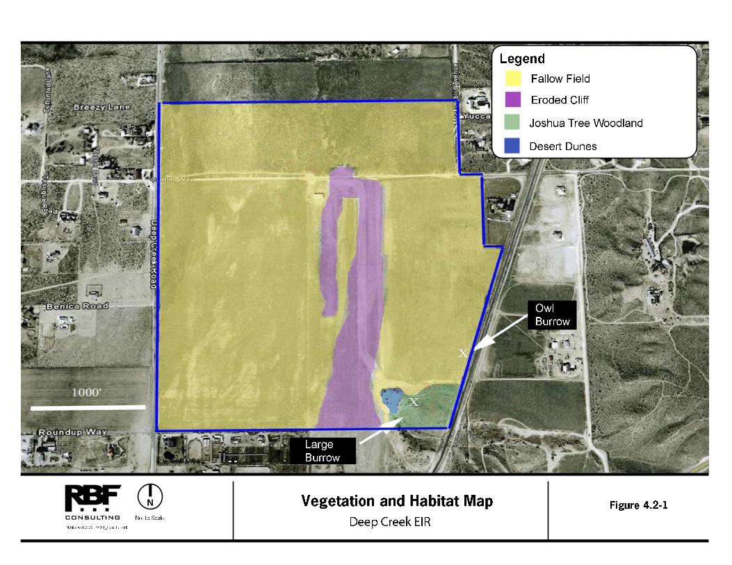
Three plant communities occur on the project site (refer to Figure 4.2-1, Vegetation and Habitat Map): Joshua Tree Woodland (4.5 acres), Desert Dunes (.75 acres), and fallow Agricultural Land (approximately 244 acres). A total of 52 plant species were identified on site, of which 11 (21%) were non-native species. While the amount of non-native species was low, non-native species account for the majority of cover on both the upper and lower terraces south of Ocotillo Way. The following are descriptions of the onsite plant communities:
Joshua Tree Woodland
Approximately 4.5 acres of Joshua Tree Woodland occurs on the project site. Joshua tree habitats generally occur at moderate elevations in the Mojave Desert between creosote bush scrub and pinyon-juniper woodlands. The Joshua tree is a large, erect, evergreen, arborescent monocot. Joshua tree is the largest non-riparian plant of the Mojave Desert, reaching heights of 16 to 49 feet.
Desert Dunes
Sand Dunes occur on approximately .75 acres of the project site. Prevailing winds carry sands from dry lakes and washes to form sand dunes. At first glance, dunes appear to be barren but there are plants that can find sufficient moisture to survive.
DEEP CREEK PROJECT 4.2 BIOLOGICAL RESOURCES DRAFT EIR
County of San Bernardino December 2010 4.2-3
Agricultural Land
Based on irrigation equipment and residual furrows, the majority of the property was cultivated in the past. Recently however, the property has been heavily grazed by cattle. Cattle grazing activities can result in disturbances in the form of soil compaction and deposition of animal waste.
SENSITIVE BIOLOGICAL RESOURCES
The biological resource analysis for the project area included an evaluation of sensitive biological resources. The California Department of Fish and Game’s (CDFG’s) California Natural Diversity Database (CNDDB) identifies plants and habitats considered to be sensitive, due to their scarcity or their potential to support State and/or Federal listed endangered or threatened plants. All records of special status species were reviewed that occur within the 7.5-minute United States Geological Survey (USGS) Apple Valley South, Apple Valley North, Victorville and Hesperia quadrangles. Within these areas, five special status plant species were identified, according to the CDFG’s CNDDB. These plant species include: Booth’s evening-primrose, desert cymopterus, short-joint beavertail, Sierra skullcap, and the San Bernardino aster.

DEEP CREEK PROJECT 4.2 BIOLOGICAL RESOURCES DRAFT EIR
County of San Bernardino December 2010 4.2-4
This page was intentionally left blank

DEEP CREEK PROJECT 4.2 BIOLOGICAL RESOURCES DRAFT EIR
County of San Bernardino December 2010 4.2-6
This page was intentionally left blank
DEEP CREEK PROJECT 4.2 BIOLOGICAL RESOURCES DRAFT EIR
County of San Bernardino December 2010 4.2-7
However, of these five, appropriate habitat was identified on-site for Booth's evening-primrose (Camissonia boothii ssp. boothii), desert cymopterus (Cymopterus deserticola), and short-joint beavertail (Opuntia basilaris var. brachyclada).
Focused Surveys
Prior to visiting the site, background information was gathered to determine what species of plant communities would be expected in this area. This background check included a search of the CNDDB and a review of previously conducted biological surveys. The project site was surveyed for the presence or absence of Booth's evening-primrose (Camissonia boothii ssp. boothii), desert cymopterus (Cymopterus deserticola), and short-joint beavertail (Opuntia basilaris var. brachyclada). The survey was conducted on May 2, 2008, approximately 6 weeks after the last rainfall event on March 16, 2008. Rainfall was higher than normal with 9.27 inches falling between September 1, 2007 and May 2, 2008.
Booth’s Evening-Primrose (Camissonia boothii ssp. Boothii) Due to the presence of abundant habitat on-site and existing plant populations within 6 miles of the site along the Mojave River, there is a strong likelihood that this species may have occurred onsite. However, grazing, agricultural operations, and rural development in the area could have let to expiration of this species from the area. Booth’s Evening-Primrose was not found to occur on the project sire during this or previous surveys conducted. Desert Cymopterus (Cymopterus deserticola)
Appropriate habitat for the Desert Cymopterus is identified onsite, particularly in the Joshua tree woodland area and associated dune-like habitat (southeast corner of the property). However this area has been heavily impacted by recent cattle-grazing. No species within the Apiaceae family was found during this survey or any previous surveys.
Short-Joint Beavertail (Opuntia basilaris var. brachyclada)
The Short-Joint Beavertail was not found during the May 2, 2008 site survey conducted as a part of the project. However, the CNDDB indicates that this sensitive species has been documented to occur in USGS – Apple Valley South Quadrangle, 7.5-Minute Series. While the cited elevational range for the species is between 1,400-6,000 feet in the Apple Valley/Cajon Pass area, this species has not been found to occur below 3000 feet. Surveys indicate that this species primarily occurs in the most xeric stage of chaparral and the more mesic stage of creosote scrub and Joshua tree woodland communities. Thus while there is nominal habitat at the Deep Creek site (e.g., Joshua Tree woodland) it is not within the species range of tolerance.
Table 4.2-1, Special Status Plant Species within the Project Area, lists the 21 sensitive plants that have been recorded within the USGS-Apple Valley South Apple Valley North, Victorville, and Hesperia Quadrangles region, and therefore, could potentially occur on the project site. As
DEEP CREEK PROJECT 4.2 BIOLOGICAL RESOURCES DRAFT EIR
County of San Bernardino December 2010 4.2-8
identified in Table 4.2-1 and above, no sensitive plant species have been identified on-site during the focused surveys performed on May 2, 2008.
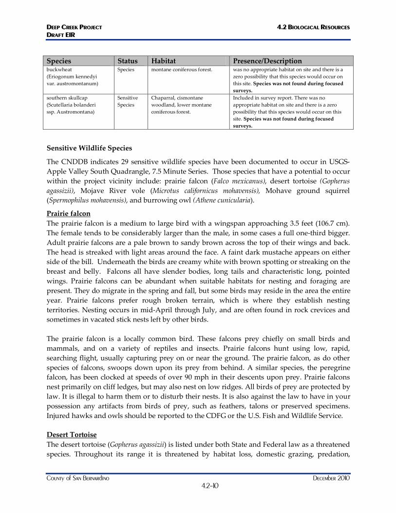
Table 4.2-1 Special Status Plant Species within the Project Area
Species Status Habitat Presence/Description Big Bear Valley woollypod (Astragalus Leucolobus)
Sensitive Species
Lower montane coniferous forest, pebble plain, pinyon and juniper woodland, upper montane coniferous forest.
There was no appropriate habitat on site and there is a zero possibility that this species would occur on this site. Species was not found during focused surveys.
Booth's evening primrose (Camissonia boothii ssp. Boothii)
Sensitive Species
Joshua tree woodland, pinyon juniper woodland.
Included in survey report. Species was not found during focused surveys.
Cushenbury oxytheca (Oxytheca parishii var. goodmaniana)
Sensitive Species
Pinyon and juniper woodland. There was no appropriate habitat on site and there is a zero possibility that this species would occur on this site. Species was not found during focused surveys.
desert cymopterus (Cymopterus deserticola)
Sensitive Species
Joshua tree woodland, mojavean desert scrub. Most occurrences located near or in Edwards AFB.
Included in survey report. Species was not found during focused surveys.
Latimer's woodland gilia (Saltugilia latimeri)
Sensitive Species
Chaparral, mojavean desert scrub.
This is primarily an eastern Mojave species and the nearest collection is 13 miles to the east at >1400m elevation. Species was not found during focused surveys.
lemon lily (Lilium parryi)
Sensitive Species
Lower montane coniferous forest, meadows and seeps, riparian forest, upper montane coniferous forest.
There was no appropriate habitat on site and there is a zero possibility that this species would occur on this site. Species was not found during focused surveys.
Mojave tarplant (Deinandra Mohavensis)
Sensitive Species
Riparian scrub, chaparral. The type collection was made at the confluence of Deep Creek and the Mojave river but this site has been extiperated and no other collections have been made in San Bernardino County since 1933. In addition, this is a Riparian species and no such habit found at the site. Species was not found during focused surveys.
Palmer's mariposa lily (Calochortus palmeri var. palmeri)
Sensitive Species
Meadows and seeps, chaparral, lower montane coniferous forest.
The Deep Creek site is much too arid and dry for this species which generally occurs along streams. There was no appropriate habitat on site and there is a zero possibility that this species would occur on this site. No Calochortus species were found during focused surveys.
Parish's daisy (Arabis parishii)
Sensitive Species
Pebble plain, pinyon juniper woodland, upper montane coniferous forest.
There was no appropriate habitat onsite and there is a zero possibility that this species would occur on this site. Species was not found during focused surveys.
Parish's desert-thorn (Lycium parishii)
Sensitive Species
Coastal scrub, sonoran desert scrub.
There is no habitat on site and this species has not been collected in San Bernardino County since 1885 and is believed extiperated from the county. There was no appropriate habitat on site and there is a zero possibility that this species would occur
DEEP CREEK PROJECT 4.2 BIOLOGICAL RESOURCES DRAFT EIR
County of San Bernardino December 2010 4.2-9
Species Status Habitat Presence/Description on this site. Species was not found during focused surveys.
Parish's rock cress (Arabis parishii)
Sensitive Species
Pebble plain, pinyon juniper woodland, upper montane coniferous forest.
Pebble Plains endemic, only found high elevation. There was no appropriate habitat onsite and there is a zero possibility that this species would occur on this site. Species was not found during focused surveys
pinyon rock cress (Arabis dispar)
Sensitive Species
Joshua tree woodland, pinyon-juniper woodland, mojavean desert scrub.
This occurs at a much higher elevation than the Deep Creek site. There was no appropriate habitat onsite and there is a zero possibility that this species would occur on this site. Species was not found during focused surveys.
Plummer’s mariposa lily (Calochortus plummerae)
Sensitive Species
Coastal scrub, chaparral, valley and foothill grassland, cismontane woodland, lower montane coniferous forest.
The project site is much too arid and dry for this species which occurs in chapparal and sage scrub. The lower elevations refer to more mesic parts of its range. There was no appropriate habitat on site and there is a zero possibility that this species would occur on this site. No calochortus species were found during focused surveys.
sagebrush loeflingia (Loeflingia squarrosa var. artemisiarum)
Sensitive Species
Great basin scrub, sonoran desert scrub, desert dunes.
The habitat on the deep Creek site would appear to be suitable for this species but the eastern and southern most population in San Bernardino county is >11 miles to the north west. Species was not found during focused surveys.
San Bernardino aster (Symphyotrichum Defoliatum)
Sensitive Species
Meadows and seeps, marshes and swamps, coastal scrub, cismontane woodland, lower montane coniferous forest, grassland.
Included in survey report. There was no appropriate habitat on site and there is a zero possibility that this species would occur on this site. Species was not found during focused surveys.
San Bernardino Mountains dudleya (Dudleya abramsii ssp. Affinis)
Sensitive Species
Pebble (pavement) plain, upper montane coniferous forest, pinyon and juniper woodland.
This is only found high elevation under more mesic conditions. There was no appropriate habitat on site and there is a zero possibility that this species would occur on this site. Species was not found during focused surveys.
San Bernardino Mountains owl's clover (Castilleja Lasiorhyncha)
Sensitive Species
Meadows, pebble plain, upper montane coniferous forest, chaparral.
Pebble Plains endemic, only found high elevation. There was no appropriate habitat on site and there is a zero possibility that this species would occur on this site. Species was not found during focused surveys.
Shockley's rock cress (Arabis shockleyi)
Sensitive Species
Pinyon and juniper woodland. It is unclear why the CNDDB lists this species as occurring at such a low elevation, all herbaria species that were viewed were collected at >1200m. The nearest population is ~13 miles east-southeast at1280m elevation. Species was not found during focused surveys.
short-joint beavertail (Opuntia basilaris var. Brachyclada)
Sensitive Species
Chaparral, Joshua tree woodland, mojavean desert scrub, pinyon-juniper woodland, riparian woodland.
Included in survey report. There was no appropriate habitat onsite and there is a zero possibility that this species would occur on this site. Species was not found during focused surveys.
silver-haired ivesia (Ivesia argyrocoma)
Sensitive Species
Meadows, pebble plains, upper montane coniferous forest.
Pebble Plains, only found high elevation. There was no appropriate habitat on site and there is a zero possibility that this species would occur on this site. Species was not found during focused surveys.
southern mountain Sensitive Pebble (pavement) plain, lower Pebble Plains, only found high elevation. There
DEEP CREEK PROJECT 4.2 BIOLOGICAL RESOURCES DRAFT EIR
County of San Bernardino December 2010 4.2-10
Species Status Habitat Presence/Description buckwheat (Eriogonum kennedyi var. austromontanum)
Species montane coniferous forest. was no appropriate habitat on site and there is a zero possibility that this species would occur on this site. Species was not found during focused surveys.
southern skullcap (Scutellaria bolanderi ssp. Austromontana)
Sensitive Species
Chaparral, cismontane woodland, lower montane coniferous forest.
Included in survey report. There was no appropriate habitat on site and there is a zero possibility that this species would occur on this site. Species was not found during focused surveys.
Sensitive Wildlife Species
The CNDDB indicates 29 sensitive wildlife species have been documented to occur in USGS-Apple Valley South Quadrangle, 7.5 Minute Series. Those species that have a potential to occur within the project vicinity include: prairie falcon (Falco mexicanus), desert tortoise (Gopherus agassizii), Mojave River vole (Microtus californicus mohavensis), Mohave ground squirrel (Spermophilus mohavensis), and burrowing owl (Athene cunicularia).
Prairie falcon The prairie falcon is a medium to large bird with a wingspan approaching 3.5 feet (106.7 cm). The female tends to be considerably larger than the male, in some cases a full one-third bigger. Adult prairie falcons are a pale brown to sandy brown across the top of their wings and back. The head is streaked with light areas around the face. A faint dark mustache appears on either side of the bill. Underneath the birds are creamy white with brown spotting or streaking on the breast and belly. Falcons all have slender bodies, long tails and characteristic long, pointed wings. Prairie falcons can be abundant when suitable habitats for nesting and foraging are present. They do migrate in the spring and fall, but some birds may reside in the area the entire year. Prairie falcons prefer rough broken terrain, which is where they establish nesting territories. Nesting occurs in mid-April through July, and are often found in rock crevices and sometimes in vacated stick nests left by other birds. The prairie falcon is a locally common bird. These falcons prey chiefly on small birds and mammals, and on a variety of reptiles and insects. Prairie falcons hunt using low, rapid, searching flight, usually capturing prey on or near the ground. The prairie falcon, as do other species of falcons, swoops down upon its prey from behind. A similar species, the peregrine falcon, has been clocked at speeds of over 90 mph in their descents upon prey. Prairie falcons nest primarily on cliff ledges, but may also nest on low ridges. All birds of prey are protected by law. It is illegal to harm them or to disturb their nests. It is also against the law to have in your possession any artifacts from birds of prey, such as feathers, talons or preserved specimens. Injured hawks and owls should be reported to the CDFG or the U.S. Fish and Wildlife Service. Desert Tortoise The desert tortoise (Gopherus agassizii) is listed under both State and Federal law as a threatened species. Throughout its range it is threatened by habitat loss, domestic grazing, predation,

DEEP CREEK PROJECT 4.2 BIOLOGICAL RESOURCES DRAFT EIR
County of San Bernardino December 2010 4.2-11
collections, and increased mortality rates. Critical habitat for the desert tortoise was designated on February 8, 1994. The project site is not located within designated critical habitat. The desert tortoise is typically found in creosote bush scrub. They are most often found on level ground where the substrate is firm but not too rocky. Tortoise burrows are typically found at the base of shrubs, in the sides of washes and in hillsides. Recent activity at tortoise burrows may be indicated by footprints, fresh dirt on the apron of the burrow, fresh scat, crushed vegetation or recently exposed roots in the burrow wall. Tortoise scat is very distinctive and may remain on the desert floor for many years. General estimates of the age of tortoise scat can be made based upon sun bleaching and moisture levels. Home ranges for desert tortoise vary, depending upon the size and sex of a tortoise as well as the availability of food and shelter. According to the CDFG, information on the western Mojave population of desert tortoise, home range typically varies from 5 to 38 acres. Neonatal tortoises can travel up to 3-5 km after hatching. Because a single tortoise may have many burrows distributed throughout its home range, it is not possible to predict exact numbers of individuals on a site based upon burrow numbers. In 1992, the U.S. Bureau of Land Management issued the California Statewide Desert Tortoise Management Policy which included categorizing habitat into three levels of classification. The management goal for Category I areas is to maintain stable, viable populations and to increase the population where possible. The management goal for Category II areas is to maintain stable, viable populations. The management goal for Category III areas is to limit population declines to the extent feasible. The entire project occurs in desert tortoise habitat designated as Class II. Mojave River Vole Mojave River vole (Microtus californicus mohavensis) is a U.S. Fish and Wildlife Services (USFWS) Species of Concern and BLM Sensitive California, Species of Special Concern (CDFG 1998). The Mojave River vole, also referred to as the Mojave River meadow mouse, is one of 17 named subspecies of the California vole, Microtus californicus. The species is restricted to moist habitats along the Mojave River between Victorville and Helendale. Appropriate habitat may also exist upstream of Victorville towards Hesperia. The Mojave River vole measures 7.5 to 8.4 inches in total length. It has brown fur overlaid with longer black hairs above, grayish below. The tail is black above, brown below, and averages one-third of the length of the head and body. Mojave River voles construct runways in grassy habitats by clipping vegetation. These runways often lead to shallow burrows in friable soil. They forage primarily on the stems and leaves of grasses and forbs, but will switch to grass seeds during the drier parts of the year. Suitable habitat is associated with ponds and irrigation canals along with the Mojave River proper. Elevations of known localities range between 750-823 meters (2325-2700 feet). The primary threats to the Mojave River vole are the destruction and fragmentation of habitat resulting from agriculture and urbanization. Urbanization adjacent to the Mojave River restricts the availability of upland habitat that may be critical during flood events. Agricultural development affects this subspecies by removing and modifying native habitats. Channelization of surface water and pumping of groundwater may continue to be a significant threat along the
DEEP CREEK PROJECT 4.2 BIOLOGICAL RESOURCES DRAFT EIR
County of San Bernardino December 2010 4.2-12
Mojave River. Introduction and spread of salt cedar (Tamarix sp.) displaces native plants and alters the composition and structure of native plant communities. Concentrated off-highway vehicle use and other surface-disturbing activities also threaten the species by removing vegetation required for foraging and cover. Mohave Ground Squirrel The Mohave Ground Squirrel (MGS) is endemic to 2 million hectares in the western Mojave Desert. It typically inhabits sandy soils of alkali sink and creosote bush scrub habitat. MGS are listed as threatened by CDFG due to habitat loss, fragmentation, and deterioration, however, CDFG does not designate critical habitat. This species measures about 9 inches from nose to tip of tail, forages on leaves and seeds, and aestivates/hibernates for long periods of the year. Aestivation (reduction of body temperature, heart rate, and metabolism) begins usually in the early summer when vegetation begins to dry up. MGS reanimate after winter rains have produced new vegetative growth, generally in February. Males may travel up to a mile per day in search of mates after they have emerged from aestivation in the spring. Litters of six to nine young are born by the end of March; are weaned by early May; and disperse a few weeks later. Young often establish home ranges adjacent to the maternal home range; however some young will disperse up to 4 miles. When winter rains fail, MGS do not reproduce and can enter dormancy as early as April. As a result, MGS numbers decline after a low rainfall year, and two successive years of drought can lead to the extinction of local populations. Young can recolonize suitable habitat rapidly after good reproductive seasons. In the Coso Grazing Exclosure Monitoring Study several individuals survived until 5 years of age, the maximum lifespan recorded for this species. In general, the majority of juveniles do not survive to reach one year of age. Evidence from radiotelemetery and weight gain patterns suggest that juvenile survivorship is low because of predation and the frequent failure of juveniles to accumulate sufficient fat reserves for their first season of dormancy. However, once individual ground squirrels successfully reach yearling status and become established in a home range, survivorship tends to be high. Plants documented as forage for MGS include: fiddleneck (Amsinckia tessellata), wolfberry (Lycium andersonii), Joshua tree (Yucca brevifolia), winterfat (Krascheninnikovia (formerly Eurotia) lanata), spiny hopsage (Grayia spinosa), allscale (Atriplex canescens and A. polycarpa), desert holly (Hymene lytaya), coreopsis (Coreopsis sp.), Russian thistle (Salsola tragus), and the seeds of Joshua tree (Y. brevifolia). It is suspected that MGS forage on the plant species with the highest water content available at the time. Burrowing Owl The burrowing owl (Athene cunicularia) is a State and Federal Species of Special Concern. This owl is a mottled brown and sand color, dove-sized raptor, with large yellow eyes, a rounded head lacking ear tufts, white eyebrows, and long legs (compared to other owl species). It is a ground dwelling owl typically found in arid prairies, fields, and open areas where vegetation is
DEEP CREEK PROJECT 4.2 BIOLOGICAL RESOURCES DRAFT EIR
County of San Bernardino December 2010 4.2-13
sparse and low to the ground. The burrowing owl is heavily dependent upon the presence of mammal burrows, commonly ground squirrel, in its habitat to provide shelter from predators, inclement weather, and a nesting place. They are also known to make use of human-created structures such as cement culverts and pipes for burrows. Burrowing owls spend a great deal of time standing on dirt mounds at the entrance to a burrow, or perched on a fence post or other low to the ground perch from which they hunt for prey. Burrowing owls frequently hunt by hovering in place above the ground and dropping on their prey from above. Burrowing owls feed primarily on insects, such as grasshoppers, June beetles and moths, but will also take small rodents, birds and reptiles. They are active during the day and night, but are considered a crepuscular owl; generally observed in the early morning hours or at twilight. The breeding season for the burrowing owl is February 1 through August 31. Up to 11, but typically 7 to 9 eggs are laid in a burrow, abandoned pipe, or other subterranean hollow where incubation is complete in 28-30 days. Young burrowing owls fledge in 44 days. The burrowing owl is considered a migratory species in portions of its range, which includes western North America from Canada to Mexico, and east to Texas and Louisiana. Burrowing owl populations in California are considered to be sedentary or locally migratory. Throughout its range it is vulnerable to habitat loss, predation, vehicular collisions, destruction of burrow sites and poisoning of ground squirrels. Burrowing owls have disappeared from significant portions of their range in the last 15 years and overall nearly 60% of the breeding groups of owls known to have existed in California during the 1980s had disappeared by the early 1990s. The burrowing owl is not listed under the State or Federal Endangered Species Act, but is considered both a Federal and State “Species of Special Concern.” The burrowing owl is a migratory bird protected by the international treaty under the Migratory Bird Treaty Act of 1918 and by State law under the California Fish and Game Code.
Focused Surveys
Prior to visiting the site, background information was gathered to determine what species would be expected in this area. This background check included a search of the CNDDB and a review of previously conducted biological surveys. The project site was surveyed for the presence or absence of prairie falcon (Falco mexicanus), desert tortoise (Gopherus agassizii), Mojave River vole (Microtus californicus mohavensis), Mohave ground squirrel (Spermophilus mohavensis), and burrowing owl (Athene cunicularia). The survey was conducted on August 19, 2008, August 25, 2008, and September 12, 2008.
Burrowing Owl (Athene cunicularia)
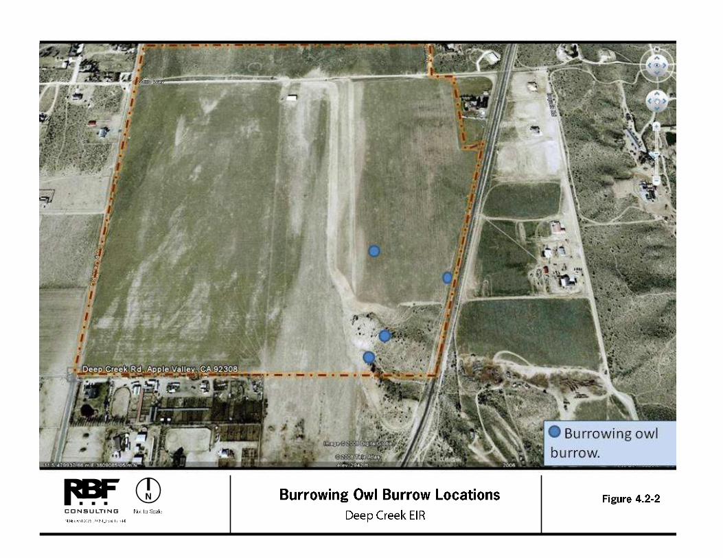
Evidence of burrowing owl was found on the project site in the southeastern quarter of the parcel; refer to Figure 4.2-2, Burrowing Owl Burrow Locations. Four burrows were found in this area, with old sign including white wash, castings, and feathers found near the entrances to the burrows. No burrowing owl individuals were found during the
DEEP CREEK PROJECT 4.2 BIOLOGICAL RESOURCES DRAFT EIR
County of San Bernardino December 2010 4.2-14
surveys. Therefore, suitable burrowing owl habitat occurs in the southeastern quarter of the project site.
Desert Tortoise (Gopherus agassizii) The project site is not located within designated critical habitat for the desert tortoise and, according to the West Mojave Conservation Plan, the project site is located in an area where desert tortoise are considered extirpated. Surveys were conducted between July 21, 2010, and July 26, 2010. No desert tortoise sign was found within the project boundaries. Additional surveys were conducted at 200, 400, and 600 meters from the project boundary, and no desert tortoise sign was found within these transects. Protocols established by the U.S. Fish and Wildlife Service for desert tortoise surveys were followed except that the survey was conducted outside of the specified survey season. Approval was granted by the U.S. Fish and Wildlife Service for conducting this survey outside of the normal survey season. The lack of desert tortoise sign indicates that the site is not currently occupied by desert tortoise.
Mohave Ground Squirrel (Spermophilus mohavensis)
Although the site is located within the range of the Mohave ground squirrel (MGS), a habitat assessment conducted in 2006 by O’Farrell Biological Consulting determined that habitat onsite is not suitable for Mohave ground squirrel. The CDFG concurred with this assertion and a 2008 field evaluation conducted by Tom Dodson and Associates also corroborated these findings.
Mojave River Vole (Microtus californicus mohavensis)
The project site is located approximately three miles south of the nearest known occurrence of the Mojave River vole. The preferred habitat of the Mojave River vole occurs within the benches and vegetated channel of the Mojave River. This species requires dense vegetation cover with high moisture content. Since these conditions do not exist onsite, the site is not considered suitable for Mojave River vole.
Prairie Falcon (Falco mexicanus)
The project site provides habitat for a variety of birds, some of which are appropriate prey species of prairie falcon. There was no sign of prairie falcons onsite during the surveys, but there is moderate potential for this species to utilize the site for foraging. There is no indication that prairie falcon use the site for roosting or nesting, and appropriate habitat capable of supporting prairie falcon nesting does not exist onsite. However, it should be assumed that the project site will be used for foraging by this species.

DEEP CREEK PROJECT 4.2 BIOLOGICAL RESOURCES DRAFT EIR
County of San Bernardino December 2010 4.2-16
This page was intentionally left blank
DEEP CREEK PROJECT 4.2 BIOLOGICAL RESOURCES DRAFT EIR
County of San Bernardino December 2010 4.2-17
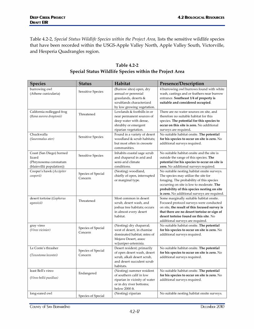
Table 4.2-2, Special Status Wildlife Species within the Project Area, lists the sensitive wildlife species that have been recorded within the USGS-Apple Valley North, Apple Valley South, Victorville, and Hesperia Quadrangles region.
Table 4.2-2 Special Status Wildlife Species within the Project Area
Species Status Habitat Presence/Description burrowing owl (Athene cunicularia)
Sensitive Species (Burrow sites) open, dry annual or perennial grasslands, deserts & scrublands characterized by low growing vegetation.
4 burrowing owl burrows found with white wash, castings and or feathers near burrow entrance. Southeast 1/4 of property is suitable and considered occupied.
California redlegged frog (Rana aurora draytonii)
Threatened Lowlands & foothills in or near permanent sources of deep water with dense, shrubby or emergent riparian vegetation.
There are no water sources on site, and therefore no suitable habitat for this species. The potential for this species to occur on this site is zero. No additional surveys are required.
Chuckwalla (Sauromalus ater)
Sensitive Species Found in a variety of desert woodland & scrub habitats; but most often in creosote communities.
No suitable habitat onsite. The potential for his species to occur on site is zero. No additional surveys required.
Coast (San Diego) horned lizard (Phrynosoma coronatum (blainvillii population))
Sensitive Species Inhabits coastal sage scrub and chaparral in arid and semi-arid climate conditions.
No suitable habitat onsite and the site is outside the range of this species. The potential for his species to occur on site is zero. No additional surveys required.
Cooper's hawk (Accipiter cooperii)
Species of Special Concern
(Nesting) woodland, chiefly of open, interrupted or marginal type.
No suitable nesting habitat onsite surveys. The species may utilize the site for foraging. The probability of this species occurring on site is low to moderate. The probability of this species nesting on site is zero. No additional surveys are required.
desert tortoise (Gopherus agassizii)
Threatened Most common in desert scrub, desert wash, and joshua tree habitats; occurs in almost every desert habitat.
Some marginally suitable habitat onsite. Focused protocol surveys were conducted on site, the result of this focused survey is that there are no desert tortoise or sign of desert tortoise found on this site. No additional surveys are required.
gray vireo (Vireo vicinior)
Species of Special Concern
(Nesting) dry chaparral; west of desert, in chamise dominated habitat; mtns of Mojave Desert, assoc w/juniper-artemisia.
No suitable habitat onsite. The potential for his species to occur on site is zero. No additional surveys required.
Le Conte's thrasher
(Toxostoma lecontei) Species of Special Concern
Desert resident; primarily of open desert wash, desert scrub, alkali desert scrub, and desert succulent scrub habitats.
No suitable habitat onsite. The potential for his species to occur on site is zero. No additional surveys required.
least Bell's vireo
(Vireo bellii pusillus) Endangered
(Nesting) summer resident of southern calif in low riparian in vicinity of water or in dry river bottoms; below 2000 ft.
No suitable habitat onsite. The potential for his species to occur on site is zero. No additional surveys required.
long-eared owl Species of Special
(Nesting) riparian No suitable nesting habitat onsite surveys.
DEEP CREEK PROJECT 4.2 BIOLOGICAL RESOURCES DRAFT EIR
County of San Bernardino December 2010 4.2-18
Species Status Habitat Presence/Description (Asio otus)
Concern bottomlands grown to tall willows & cottonwoods; also, belts of live oak paralleling stream courses.
The species may utilize the site for foraging. The probability of this species occurring on site is low to moderate. The probability of this species nesting on site is zero. No additional surveys are required.
Mohave ground squirrel (Spermophilus Mohavensis) Threatened
Open desert scrub, alkali scrub & Joshua tree woodland. Also feeds in annual grasslands. Restricted to Mojave Desert.
The site is within the edge of its range. 2006 habitat assessment conducted by O’Farrell Biological Consulting concluded the site was not suitable. CDFG concurred and 2008 surveys confirmed the previous finding.
Mojave river vole (Microtus californicus Mohavensis)
Species of Special Concern
Occurs only in weedy herbaceous growth in wet areas along the Mojave river. May be found in some irrigated pastures.
Nearest known location is 3 miles to the north in the Mojave River. No habitat elements required by this species exist on site. This species requires very moist and densely vegetated habitat.
pallid San Diego pocket mouse (Chaetodipus fallax
Pallidus)
Species of Special Concern
Desert border areas in eastern san diego co. In desert wash, desert scrub, desert succulent scrub, pinyon-juniper, etc.
No suitable habitat onsite. The potential for his species to occur on site is zero. No additional surveys required.
prairie falcon
(Falco mexicanus) Species of Special Concern
(Nesting) inhabits dry, open terrain, either level or hilly.
Suitable habitat for foraging. This species likely occurs in the area and may utilize the site for foraging
San Emigdio blue butterfly (Plebulina emigdionis)
Sensitive Species Found in desert canyons and along riverbeds on the southernmost edge of the San Joaquin Valley
No suitablel habitat onsite, and the site is outside the range of this species. The potential for this species to occur onsite is zero. No additional surveys required.
southwestern pond turtle (Emys (Clemmys) marmorata pallida)
Species of Special Concern
Inhabits permanent or nearly permanent bodies of water in many habitat types; below 6000 ft elev.
There are no water sources on site, and therefore no suitable habitat for this species. The potential for this species to occur on this site is zero. No additional surveys are required.
southwestern willow flycatcher (Empidonax traillii extimus)
Endangered (Nesting) riparian woodlands in southern California. State listing includes all subspecies.
No suitable habitat onsite. The potential for his species to occur on site is zero. No additional surveys required.
summer tanager
(Piranga rubra) Species of Special Concern
(Nesting) summer resident of desert riparian along lower Colorado River, and locally elsewhere in California deserts.
No suitable habitat onsite. The potential for his species to occur on site is zero. No additional surveys required.
Townsend's bigeared bat (Corynorhinus Townsendii) Species of Special
Concern
Throughout california in a wide variety of habitats. Most common in mesic sites.
No suitable habitat onsite. The potential for his species to occur on site is zero. No additional surveys required.
western yellowbilled cuckoo (Coccyzus Americanus occidentalis)
Endangered (Nesting) riparian forest nester, along the broad, lower flood-bottoms of larger river systems.
No suitable habitat occurs onsite. The probability of this species occurring on site is zero. Additional surveys are not required.
yellow warbler (Dendroica petechia
Brewsteri)
Species of Special Concern
(Nesting) riparian plant associations. Prefers willows, cottonwoods, aspens, sycamores, and
No suitable habitat onsite. The potential for his species to occur on site is zero. No additional surveys required.
DEEP CREEK PROJECT 4.2 BIOLOGICAL RESOURCES DRAFT EIR
County of San Bernardino December 2010 4.2-19
Species Status Habitat Presence/Description alders for nesting and foraging.
yellow-breasted chat
(Icteria virens) Species of Special Concern
(Nesting) summer resident; inhabits riparian thickets of willow & other brushy tangles near watercourses.
No suitable habitat onsite. The potential for his species to occur on site is zero. No additional surveys required.
Regional Connectivity/Wildlife Movement
Wildlife movement corridors are defined as areas that connect suitable wildlife habitat areas in a region otherwise fragmented by rugged terrain, changes in vegetation, or human disturbance. A wildlife corridor is generally represented by a linear patch of habitat that provides a connection between two core areas of the same habitat, allowing for the large-scale movement of species within their native habitats. Natural features such as canyon drainages, ridgelines, or areas with vegetation cover provide corridors for wildlife travel. Wildlife movement corridors are important because they provide access to mates, food, and water; allow the dispersal of individuals away from high population density areas; and facilitate the exchange of genetic traits between populations.
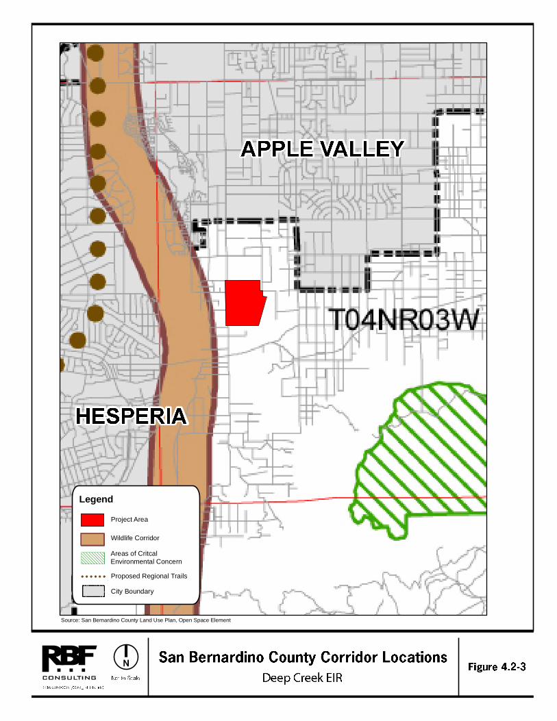
The project site is not identified within the San Bernardino County General Plan as a Wildlife Corridor or Linkage; refer to Figure 4.2-3, San Bernardino County Corridor Locations. The County identifies Wildlife Corridors and Areas of Critical Environmental Concern in their open space element of the General Plan.

DEEP CREEK PROJECT 4.2 BIOLOGICAL RESOURCES DRAFT EIR
County of San Bernardino December 2010 4.2-20
This page was intentionally left blank
Legend
Wildlife Corridor
Areas of Critcal Environmental Concern
Proposed Regional Trails
City Boundary
Project Area
Source: San Bernardino County Land Use Plan, Open Space Element

DEEP CREEK PROJECT 4.2 BIOLOGICAL RESOURCES DRAFT EIR
County of San Bernardino December 2010 4.2-22
This page was intentionally left blank
DEEP CREEK PROJECT 4.2 BIOLOGICAL RESOURCES DRAFT EIR
County of San Bernardino December 2010 4.2-23
The site encompasses a large area of open land and although it is not within the San Bernardino County’s identified wildlife corridor, it is located east of the Mojave River Wildlife Corridor.
REGULATORY FRAMEWORK
FEDERAL
Administered by the United States Fish and Wildlife Services (USFWS), the Federal Endangered Species Act (ESA) provides the legal framework for the listing and protection of species (and their habitats) that are identified as being endangered or threatened with extinction. Actions that jeopardize endangered or threatened species and the habitats upon which they rely are considered a “take” under the ESA. Section 9(a) of the ESA defines take as “to harass, harm, pursue, hunt, shoot, wound, kill, trap, capture, or collect, or attempt to engage in any such conduct.” “Harm” and “harass” are further defined in Federal regulations and case law to include actions that adversely impair or disrupt a listed species’ behavioral patterns.
Sections 4(d), 7 and 10(a) of the Federal ESA regulate actions that could jeopardize endangered or threatened species. A special rule under Section 4(d) of the ESA was finalized which authorizes “take” of certain protected species under approved Natural Communities Conservation Programs (NCCPs), which are administered by the states. Section 7 describes a process of Federal interagency consultation for use when Federal actions may adversely affect listed species. A Section 7 consultation is required when there is a nexus between endangered species’ use of a site and impacts to ACOE jurisdictional areas. Section 10(a) allows issuance of permits for incidental take of endangered or threatened species with preparation of a habitat conservation plan (HCP). The term “incidental” applies if the taking of a listed species is incidental to and not the purpose of an otherwise lawful activity. A HCP demonstrating how the taking would be minimized and how steps taken would ensure the species’ survival must be submitted for issuance of Section 10(a) permits.
The USFWS identifies critical habitat for endangered and threatened species. Critical habitat is defined as areas of land that are considered necessary for endangered or threatened species to recover. The ultimate goal is to restore healthy populations of listed species within their native habitat so they can be removed from the list of threatened or endangered species. Once an area is designated as critical habitat pursuant to the Federal ESA, all Federal agencies must consult with the USFWS to ensure that any action they authorize, fund, or carry out is not likely to result in destruction or adverse modification of the critical habitat.
STATE OF CALIFORNIA
The California ESA is similar to the Federal ESA in that it contains a process for listing of species and regulating potential impacts to listed species. Section 2081 of the California ESA authorizes the CDFG to enter into a memorandum of agreement for take of listed species for scientific, educational, or management purposes.

DEEP CREEK PROJECT 4.2 BIOLOGICAL RESOURCES DRAFT EIR
County of San Bernardino December 2010 4.2-24
The Native Plant Protection Act (NPPA) enacted a process by which plants are listed as rare or endangered. The NPPA regulates collection, transport, and commerce in plants that are listed. The California ESA followed the NPPA and covers both plants and animals that are determined to be endangered or threatened with extinction. Plants listed as rare under the NPPA are also designated rare under the California ESA.
The California Environmental Quality Act (CEQA) and its implementing guidelines (CEQA Guidelines) require discretionary projects with potentially significant effects (or impacts) on the environment to be submitted for environmental review. Mitigation for significant impacts to the environment is determined through the environmental review process, in accordance with existing laws and regulations.
Raptors (birds of prey) and active raptor nests are protected by California Fish and Game Code 3503, which states that it is "unlawful to take, possess, or destroy any birds of prey or to take, possess, or destroy the nest or eggs of any such bird" unless authorized (CDFG 1991).
In addition, all migratory bird species that are native to the U.S. or its territories are protected under the Federal Migratory Bird Treaty Act (MBTA), as amended under the Migratory Bird Treaty Reform Act of 2004 (FR Doc. 05-5127; USFWS 2004). The MBTA is generally protective of migratory birds but does not actually stipulate the type of protection required. In common practice, USFWS places restrictions on disturbances allowed near active raptor nests.
LOCAL
West Mojave Plan
The West Mojave Plan is a Habitat Conservation Plan and California Desert Conservation Area Plan Amendment. The goal of the West Mojave Plan is to conserve and protect the desert tortoise, Mohave Ground Squirrel, and nearly 100 other sensitive plants and animals, as well as the ecosystems on which they depend. At the same time, the West Mojave Plan is intent on providing developers of public and private projects with a streamlined program for compliance with the California and Federal Endangered Species Acts that regulates consistently, reduces delays and expenses, eliminates uncertainty, and applies the costs of compensation and mitigation equitably to all agencies and parties.
The West Mojave Plan is an attempt at defining a regional strategy for conserving plant and animal species and their habitats and to define an efficient, equitable, and cost-effective process for complying with threatened and endangered species laws. In March of 2006, the Bureau of Land Management signed a Record of Decision for the Final Version of the Plan. However, in August of the same year, an alliance of conservation groups filed suit in Federal Court to overturn the Plan, charging that it does not protect land and wildlife from off-road vehicles. As a result, the Habitat Conservation Plan component of the West Mojave Plan is still considered to be a draft, and is anticipated to require at least two more years for completion. At this time, since the Plan is still considered to be in draft form, it cannot be relied upon for compliance with
DEEP CREEK PROJECT 4.2 BIOLOGICAL RESOURCES DRAFT EIR
County of San Bernardino December 2010 4.2-25
Federal, State, and local laws and regulations pertaining to endangered and sensitive plant and animal species.
California Desert Native Plants Act
The California Desert Native Plants Act was passed in 1981 to protect non-listed California desert native plants from unlawful harvesting on both public and privately owned lands. Harvest, transport, sale, or possession of specific native desert plants is prohibited unless a person has a valid permit. The following plants are under the protection of the California Desert Native Plants Act:
Dalea spinosa (smoketree)
All species of the genus Prosopis (mesquites)
All species of the family Agavaceae (century plants, nolinas, yuccas)
All species of Cactus
Creosote Rings, ten feet in diameter or greater
All Joshua Trees
County of San Bernardino General Plan (2007)
The Conservation Element of the County of San Bernardino General Plan identifies measures to preserve the unique environmental features and natural resources of the desert region, including native wildlife and vegetation. One role of the Conservation Element involves the identification of a community’s natural resources and the adoption of policies for their preservation, development, and wise use. The following goals, policies, and programs are applicable to the proposed project:
Goal CO 1: The County will maintain to the greatest extent possible natural resources that contribute to the quality of life within the County
Policy CO 3.1: The County will coordinate with appropriate agencies and interested groups to develop, fund and implement programs to maintain the County’s natural resources’ base.
Programs: 1. The County shall coordinate with local interest groups, State, and
Federal agencies, prior to the approval of land use conversion to ensure adequate protections are in place to preserve habitat for resident and migratory species that may depend on aquatic, riparian, and/or unique upland habitat within the County. The Overlay will be designed to identify the known distribution of rare, threatened and endangered species and the habitats they rely upon.
DEEP CREEK PROJECT 4.2 BIOLOGICAL RESOURCES DRAFT EIR
County of San Bernardino December 2010 4.2-26
2. The County will coordinate with appropriate agencies (e.g., USFWS, California Natural Diversity Data Base, BLM, National Park Service, California Native Plant Society, and so forth) and interested groups (e.g., Audubon Society, San Bernardino County Museum) to develop, fund and implement a geographic information and web-based database system for identifying important biological resources and natural open space areas within the Valley, Mountain, and Desert Regions of the County. The implementation of the aforementioned geographic information and database system is a commitment to update and enhance the Biological and Open Space Overlays within a specific area prior to approval of any subsequent development plans. This program includes the maintenance of the web-based database with completed Biological Opinions that will contribute to the evaluation of cumulative impacts from previously approved projects. Furthermore, the County shall quarterly fund the San Bernardino County Museum (Museum) to review and update the Biological Resources and Open Space Overlays to facilitate an accurate and current spatial data based on local, State, and Federally protected species and their habitats.
Goal CO 2: The County will maintain and enhance biological diversity and healthy
ecosystems throughout the County. Policy CO 2.1: The County will coordinate with State and Federal agencies and
departments to ensure that their programs to preserve rare and endangered species and protect areas of special habitat value, as well as conserve populations and habitats of commonly occurring species, are reflected in reviews and approvals of development programs.
Programs: 1. All County Land Use Map changes and discretionary land use
proposals, for areas within the Biotic Resource Overlay or Open Space Mapping on the Resources Overlay, shall be accompanied by a report that identifies all biotic resources located on the site and those on adjacent parcels, which could be adversely affected by the proposal. The report shall outline mitigation measures designed to eliminate or reduce impacts to identified resources. An appropriate expert such as a qualified biologist, botanist, herpetologist or other professional “life scientist” shall prepare the report.
2. The County shall require the conditions of approval of any land use application to incorporate the County’s identified mitigation measures in addition to those that may be required by State or Federal agencies to protect and preserve the habitats of the identified species. This measure is
DEEP CREEK PROJECT 4.2 BIOLOGICAL RESOURCES DRAFT EIR
County of San Bernardino December 2010 4.2-27
implemented through the land use regulations of the County Development Code and compliance with the CEQA, CESA, ESA and related environmental laws and regulations.
3. The County shall coordinate with local, State, and Federal agencies to create a specific and detailed wildlife corridor map for the County of San Bernardino. The map will identify movement corridors and refuge area for large mammal, migratory species, and desert species dependent on transitory resources based on rainfall. The wildlife corridor and refuge area map will be used for preparation of biological assessments prior to permitting land use conversion within County jurisdictional areas. The mapping will be included in the Open Space and Biological Resource Overlays.
4. The County shall coordinate with State and Federal agencies and departments to ensure that their programs to preserve rare and endangered species and protect areas of special habitat value, as well as conserve populations and habitats of commonly occurring species, are reflected in reviews and approvals of development programs. This coordination shall be accomplished by notification of development applications and through distributed CEQA documents.
5. The San Bernardino County Museum (Museum) will review and update the Biological Resources Overlay and Open Space Overlay to provide accurate and current spatial data based on rare, threatened, endangered species and the habitats that they rely on. An updated database that integrates CNDDB data with other occurrence data from the Museum and other sources such as the USFWS, CDFG, USFS, BLM, National Park Service, and California Native Plant Society to identify areas where biological surveys are required. Overlay maps will identify movement corridors and refuge areas for large mammal, migratory species, and desert species dependent on transitory resources based on rainfall. South Coast Wildlands Corridor Project and other data from the resource agencies will be consulted as an information reference base. The wildlife corridor and refuge area map will be used for preparation of biological assessments prior to permitting land use conversion within County jurisdictional areas. The mapping will be included in the Open Space and Biological Resource Overlays.
Policy CO 2.2: Provide a balanced approach to resource protection and recreational use
of the natural environment.
DEEP CREEK PROJECT 4.2 BIOLOGICAL RESOURCES DRAFT EIR
County of San Bernardino December 2010 4.2-28
Policy CO 2.3: In addition to conditions of approval that may be required for specific future development proposals, the County shall establish long-term comprehensive plans for the County’s role in the protection of native species because preservation and conservation of biological resources are statewide, Regional, and local issues that directly affect development rights. The conditions of approval of any land use application approved with the BR overlay district shall incorporate the mitigation measures identified in the report required by Section 82.13.030 (Application Requirements), to protect and preserve the habitats of the identified plants and/or animals.
Programs: 1. Prepare or participate in Habitat Conservation Plans when there is
sufficient support of such plans, and adequate funding for their preparation, and a strong likelihood of success.
2. Establish a land ownership transfer program. 3. Establish a land conservation easement program. 4. The County shall work with local communities to improve trash collection, recycling programs, and reduce illegal dumping in unincorporated areas. The County shall sponsor mitigation efforts that minimize landfill growth, reduce trash haul routes that spread litter and increase predator species numbers (i.e., raven or crow in the Desert Region), and reduce illegal dumping of large bulk items (e.g., furniture, appliances, tires, batteries). 5. The County shall participate with Regional plans to improve water quality and habitat that are downstream but may be beyond County limits. The County shall coordinate with Regional plans to minimize degradation of water quality within the County that affects downstream resources and habitats.
Policy CO 2.4: All discretionary approvals requiring mitigation measures for impacts to biological resources will include the condition that the mitigation measures be monitored and modified, if necessary, unless a finding is made that such monitoring is not feasible.
Programs: 1. The monitoring program will be designed to determine whether the
mitigation measures were implemented and effective.
DEEP CREEK PROJECT 4.2 BIOLOGICAL RESOURCES DRAFT EIR
County of San Bernardino December 2010 4.2-29
2. The monitoring program will be funded by the project applicant to ensure compliance with and effectiveness of conditions of approval. 3. The County shall not permit land conversion until adequate mitigation is provided to reduce impacts to less than significant in cases where a Mitigated Negative Declaration is used for CEQA compliance. Direct and growth inducing impacts determined to cause a significant adverse effect on rare, threatened or endangered desert species shall be mitigated by avoidance, habitat restoration or compensated by off-site mitigation and evaluated through a project level EIR. Mitigation will be required for adverse impacts to critical areas around residential land conversion when it can be shown that the indirect effects of pets, associate human activity and other encroachments into sensitive habitats will be significant. 4. The County shall require all new roadways, roadway expansion, and utility installation within the wildlife corridors identified in the Open Space and Biological Resource Overlays to provide suitable wildlife crossings for affected wildlife. Design will include measures to reduce or prevent habitat fragmentation and provide wildlife a means of safe egress through respective foraging and breeding habitats. A qualified biologist will assist with the design and implementation of wildife crossing including culverts, overcrossings, undercrossings, and fencing.
County of San Bernardino Development Code (Amended January 2009)
The County of San Bernardino Development Code includes Section 88.01.060-Desert Native Plant Protection Ordinance.” This Ordinance provides regulations for the removal or harvesting of specified desert native plants in order to preserve and protect the plants and to provide for the conservation and wise use of desert resources. The provisions are intended to augment and coordinate with the Desert Native Plants Act (Food and Agricultural Code Section 80001 et seq.) and the efforts of the State Department of Food and Agriculture to implement and enforce the Act.
SIGNIFICANCE THRESHOLD CRITERIA
Appendix G of the CEQA Guidelines contains the Initial Study Checklist form, which includes questions relating to biological resources. The issues presented in the Initial Study Checklist have been utilized as Thresholds of Significance in this Section. Accordingly, a project may create a significant environmental impact if one or more of the following occurs:
If the project has a substantial adverse effect, either directly or through habitat modifications, on any species identified as a candidate, sensitive, or special status species in local or regional plans, policies, or regulations, or by the CDFG or USFWS.
DEEP CREEK PROJECT 4.2 BIOLOGICAL RESOURCES DRAFT EIR
County of San Bernardino December 2010 4.2-30
If the project has a substantial adverse effect on any riparian habitat or other sensitive natural community identified in local or regional plans, policies, regulations, or by the CDFG or USFWS.
If the project has a substantial adverse effect on Federally protected wetlands as defined by Section 404 of the Clean Water Act (including, but not limited to, marsh, vernal pool, coastal, etc.) through the direct removal, filling, hydrological interruption, or other means.
If the project interferes substantially with the movement of any native or migratory fish or wildlife species or with established native resident or migratory wildlife corridors, or impedes the use of native wildlife nursery sites.
If the project conflicts with any local policies or ordinances protecting biological resources, such as a tree preservation policy or ordinance.
If the project conflicts with the provisions of an adopted Habitat Conservation Plan, Natural Community Conservation Plan, or other approved local, regional, or State habitat conservation plan.
Section 15065 (a), Mandatory Findings of Significance, of the CEQA Guidelines states that a project may have a significant effect on the environment if “the project has the potential to substantially degrade the quality of the environment, substantially reduce the habitat of a fish or wildlife species, cause a fish or wildlife population to drop below self-sustaining levels, threaten to eliminate a plant or animal community, [or] reduce the number or restrict the range of an endangered, rare, or threatened species.”
The significance of an impact on biological resources considers the resource itself and the importance of that resource in a regional or local context. Those impacts that diminish, or result in the loss of, an important biological resource, or those that would conflict with local, State, or Federal resource conservation plans, goals, or regulations are considered to be significant. Impacts may be locally adverse but not significant if they would not substantially diminish or result in the permanent loss of an important resource on a population- or region-wide basis, although they may result in an adverse alteration of existing conditions.
IMPACTS AND MITIGATION MEASURES
Sensitive Species
Impact 4.2-1: Implementation of the proposed project may have a substantial adverse effect, either
directly or through habitat modifications, on any species identified as a candidate, sensitive, or special status species in local or regional plans, policies, or regulations, or by the California Department of Fish and Game or U.S. Fish and Wildlife Service. Level of Significance: Less than Significant with Mitigation.
DEEP CREEK PROJECT 4.2 BIOLOGICAL RESOURCES DRAFT EIR
County of San Bernardino December 2010 4.2-31
Construction activities and operation of the proposed project may result in potential direct or indirect impacts to special status species or other sensitive species. Primary short-term impacts to vegetation and wildlife would result from the removal or alteration of physical habitats that can be re-vegetated and reclaimed within a 3- to 5-year period. Construction activities would involve grubbing, trenching, grading, stockpiling, and other soil-disturbing activities. The removal or alteration of native and non-native habitats within a project area could result in the temporary or permanent displacement of plants, vegetation types, small mammals, reptiles, amphibians, and other animals. Short-term construction-related impacts would also include increased noise, lessened air quality due to fugitive dust and equipment emissions, and construction traffic on local roads. These factors could disrupt the behavioral and reproductive patterns of wildlife. Additionally, construction activities would increase sedimentation and pollutant load due to fuels, oils and other hazardous materials from construction vehicles in stormwater runoff.
Development of the project area would change the current land use from undeveloped land to residential uses. Proposed development would affect the majority of the project site. As such, existing biological resources that are present on the site would largely be eliminated with project implementation, particularly with mass grading of the site in preparation for the proposed development.
Sensitive biological resources are defined as species under study for classification as threatened or endangered, or have low population densities or a highly restricted range. As identified in Tables 4.2-1 and 4.2-2, above, a total of 44 sensitive plant and wildlife species were identified as being known to exist, may exist, or have been seen in the vicinity of the project site. After a general site survey was conducted, it was determined that species specific surveys were necessary for eight species because potential suitable habitat was found on the project site. The remaining 36 species were not found to have suitable habitat onsite and therefore were not surveyed. The project site was surveyed for the presence or absence of Booth's evening-primrose (Camissonia boothii ssp. boothii), desert cymopterus (Cymopterus deserticola), short-joint beavertail (Opuntia basilaris var. brachyclada), prairie falcon (Falco mexicanus), desert tortoise (Gopherus agassizii), Mojave River vole (Microtus californicus mohavensis), Mohave ground squirrel (Spermophilus mohavensis), and burrowing owl (Athene cunicularia). A discussion of these species follows:
Booth’s Evening-Primrose
There is abundant habitat at the site and populations within 6 miles both north and south along the Mojave River would indicate the for this species to have historically occurred on the site. However, focused surveys determined that it is not presently occurring on the site. Grazing, agricultural, and rural development in the past could have led to it’s extirpation from the area.
Desert Cymopterus
There is appropriate habitat on the site, particularly in the Joshua tree woodland area and associated dune-like habitat in the southeast corner of the property. However, this
DEEP CREEK PROJECT 4.2 BIOLOGICAL RESOURCES DRAFT EIR
County of San Bernardino December 2010 4.2-32
area has been heavily grazed by cattle recently. Neither this species, nor any species in the Apiaceae, were found during the focused surveys of the project site.
Short-Joint Beavertail
While the cited elevational range for the species is 1,400-6,000 feet in the Apple Valley/Cajon Pass area the species has not been found to occur below 3,000 feet. In reality, O. b. brachyclada seems to primarily occur in the ecotonal grade between the above communities, specifically it occurs in the most xeric stage of chaparral and the more mesic stage of creosote scrub and Joshua tree woodland communities. Thus while there is nominal habitat at the Deep Creek site (e.g., Joshua tree woodland) it is not within range of tolerance for this species.
Prairie Falcon
The project site provides habitat for a variety of birds, some of which are appropriate prey species of the prairie falcon. There were no signs of prairie falcons on site during the surveys, but there is a moderate potential for this species to utilize the site for foraging. There is no indication that prairie falcon nesting exists onsite. Development of the site would result in impacts to potentially suitable foraging habitat for the prairie falcon. At this time, there are no regulatory permits required for impacts to prairie falcon foraging habitat. In the local vicinity of the project site, there are a number of areas suitable for prairie falcons to forage and the development of this parcel would not result in significant adverse impacts to the local or regional population of prairie falcons.
California Desert Tortoise
The California desert tortoise was listed by California as a threatened species on August 3, 1989 and Federally listed as a threatened species on April 2, 1990. Although the California desert tortoise occurs in the local area, no desert tortoise were detected onsite or within the surrounding properties during protocol survey conducted between July 21, 2010, and July 26, 2010. Surveys were conducted onsite and at 200, 400, and 600 meters from the project boundary, and no desert tortoise sign was found within these transects. Protocols established by the U.S. Fish and Wildlife Service for desert tortoise surveys were followed, except that the survey was conducted outside of the specified survey season. Approval was granted by the U.S. Fish and Wildlife Service for conducting this survey outside of the normal survey season. The lack of desert tortoise sign suggests that the site is not currently occupied by desert tortoise. To assure that the California desert tortoise has not entered the site prior to ground disturbance activities, a focused trapping survey will be conducted prior to any ground disturbing activities to conclusively rule out the presence of the species onsite at that time. Refer to Mitigation Measures BIO-1 to BIO-4.
Mojave River Vole
The project site is located approximately 3 miles south of the nearest known occurrence of the Mojave River vole. The preferred habitat of the Mojave River vole occurs within
DEEP CREEK PROJECT 4.2 BIOLOGICAL RESOURCES DRAFT EIR
County of San Bernardino December 2010 4.2-33
the benches and vegetated channel of the Mojave River. This species requires dense vegetative cover with high moisture content. Since these conditions do not exist onsite, the site is not considered suitable for Mojave River vole. There is no potential for this species to occur onsite.
Mohave Ground Squirrel
The Mohave ground squirrel was listed by California as a threatened species on June 27, 1971. According to the West Mojave Plan Environmental Impact Report/Environmental Impact Statement and according to the Mohave ground squirrel Partnership Workshop, the subject property is located within the extreme southern periphery of the Mohave ground squirrel range. In 2006, the project site was evaluated for the potential of Mohave ground squirrel by O’Farrell Biological Consulting, which concluded that, the habitat on the project site is not suitable for Mohave ground squirrel. CDFG concurred with this assertion and the site survey for Mohave ground squirrel conducted by Tom Dodson & Associates corroborated these findings. Although the project site was not identified as containing suitable habitat for Mohave ground squirrel, out of an abundance of caution, a focused trapping survey will be conducted prior to any ground disturbing activities to conclusively rule out the presence of the species onsite at that time. Refer to Mitigation Measures BIO-1 to BIO-4.
Burrowing Owl
The burrowing owl is not listed under the State or Federal Endangered Species Act, but is considered both a Federal and State “Species of Concern”. The proposed residential development project may disrupt the integrity or continuity of habitat suitable for, and presumably occupied by, the burrowing owl. Evidence of burrowing owl was found on the project site in the southeastern quarter of the parcel. Seven burrows were found in this area that had old sign including white wash, castings, and feathers near the burrow entrances. Therefore, the southeastern quarter of the project site should be assumed to provide suitable burrowing owl habitat that could become occupied. There was indication of occupation of the site by burrowing owl; however, the project site is not currently occupied.
The proposed project may disrupt the integrity or continuity of habitat suitable for burrowing owl. Implementation of mitigation measures BIO-5 through BIO-6 would reduce impacts to a level of less than significant.
Mitigation Measures:
Mitigation Measure BIO-1 Prior to approval of grading permits, the developer shall provide evidence to the County that focused desert tortoise and Mohave ground squirrel trapping surveys have been conducted. The focused surveys shall be prepared in accordance with the survey protocols established by the United States Fish and Wildlife
DEEP CREEK PROJECT 4.2 BIOLOGICAL RESOURCES DRAFT EIR
County of San Bernardino December 2010 4.2-34
Service and/or California Department of Fish and Game. If no desert tortoise and no Mohave ground squirrel are identified during the focused survey, Mitigation Measure BIO-3 shall apply. In the event one or both of these species are identified on-site, Mitigation Measure BIO-4 shall apply.
Mitigation Measure BIO-2 In lieu of Mitigation Measure BIO-1 (focused surveys), the developer may assume that both the desert tortoise and Mohave ground squirrel are present within project limits. In this case, the requirements of Mitigation Measure BIO-4 shall apply.
Mitigation Measure BIO-3 If no desert tortoise or Mohave ground squirrel are identified during onsite focused surveys, the entire site shall be immediately, completely, and adequately fenced after the surveys are conducted in order to prevent either species from entering the site prior to ground disturbing activities. “Adequate fenced” shall include desert tortoise exclusionary fencing (e.g., fine mesh [1/4” or smaller] material [hardware cloth, silt fence, snow fence, etc.] buried to at least 12 inches below the surface and 24” above ground) and positioned and maintained in a manner to prevent entry of either species on site. Should the project site be graded in phases, the exclusionary fence shall encompass all areas outside the area of active grading.
Mitigation Measure BIO-4 The developer shall mitigate for impact to the desert tortoise and/or Mohave ground squirrel by purchase of credits an a habitat conservation bank approved for each/both species. The amount, location, and condition of any such property shall be established through consultation with and approval by the United States Fish and Wildlife Service and the California Department of Fish and Game. As established through consultation with the agencies, the developer shall provide funds (e.g., endowment) to contribute to the maintenance of mitigation lands. Prior to the issuance of grading permits, the developer shall provide to the county
DEEP CREEK PROJECT 4.2 BIOLOGICAL RESOURCES DRAFT EIR
County of San Bernardino December 2010 4.2-35
evidence that it has satisfactorily met the permit and/or other requirements established by either agency.
Mitigation Measure BIO-5 Prior to any ground disturbance and at the appropriate time of year (February 1 through August 31), focused breeding season surveys for burrowing owl shall be conducted in accordance with the Burrowing Owl Survey Protocol and Mitigation Guidelines approved by CDFG (the “Protocol”), as then applicable. If burrowing owls are observed during those surveys, a Burrowing Owl Mitigation and Monitoring Plan (the “Plan”) shall be submitted to CDFG for review and approval prior to relocation of owls. The Plan shall describe any proposed relocation and monitoring plans. The Plan shall include the number and location of occupied burrow sites and details on adjacent or nearby suitable habitat available to owls for relocation. If no suitable habitat is available for nearby relocation, details regarding the creation of artificial burrows (numbers, location, and types of burrows) shall also be included in the Plan. The Plan shall also describe proposed off site areas to compensate for impacts to burrowing owls/occupied burrows at the project site.
Mitigation Measure BIO-6 Where and to the extent that avoidance occurs pursuant to the Protocol, the Plan shall include the following measures::
1) Establish a setback of at least 250 feet from each owl burrow occupied within the past five years.
2) Preserve 6.5 acres of foraging habitat per burrowing owl pair, contiguous to the owl population. Configurations of foraging habitat in relation to owl burrows requires review and approval by the CDFG and USFWS.
3) Construction and other ground disturbances shall be prohibited within established setbacks and foraging habitat. Natural vegetation shall be maintained within the setback. The use of insecticides,
DEEP CREEK PROJECT 4.2 BIOLOGICAL RESOURCES DRAFT EIR
County of San Bernardino December 2010 4.2-36
herbicides, and fertilizers shall be not permitted within established setbacks.
4) Setbacks shall be marked by brightly colored fencing or flagging throughout the construction process. Setbacks shall be indicated on recorded maps, whenever projects involve parcel or subdivision maps.
5) All setbacks and foraging habitat shall be preserved in perpetuity via recordation of a conservation easement.
Mitigation Measure BIO-7 Where owls are associated with occupied burrows that would be directly impacted (temporarily or permanently) by the project and the Protocol does not require avoidance, the Plan shall include mitigation as specifically set forth in the then-effective Protocol, provided that such mitigation is determined to be equivalent to or more protective than mitigation required under (1) the presently effective Protocol (California Burrowing Owl Consortium, April 1993) and (2) the following measures:
For On-Site Mitigation:
1) Passive relocation shall encourage owls to move from occupied burrows to alternate natural or artificial burrows that are beyond 160 feet from the impact zone and that are within or contiguous to a minimum of 6.5 acres of foraging habitat for each pair of relocated owls.
2) One alternate natural or artificial burrow should be provided for each burrow that will be excavated in the project impact zone.
3) Relocation shall be by a qualified biologist. Suitable habitat must be available adjacent to or near the disturbance site or artificial burrows will need to be provided nearby. Once the biologist has confirmed that the owls have left the burrow, burrows should
DEEP CREEK PROJECT 4.2 BIOLOGICAL RESOURCES DRAFT EIR
County of San Bernardino December 2010 4.2-37
be excavated using hand tools and refilled to prevent reoccupation.
4) All relocation shall be approved by CDFG. The qualified biologist shall monitor the relocated owls daily for one week to confirm owl use and a minimum of three days per week for the following two weeks. A report summarizing the results of the relocation and monitoring shall be submitted to CDFG within 30 days following completion of the relocation and monitoring of owls.
5) Relocation shall be permitted only during the non-breeding season. Occupied burrows shall not be disturbed during nesting season of February 1 through August 31, unless a qualified biologist can verify through non-invasive methods that either the owls have not begun egg laying and incubation or juveniles from the occupied burrows are foraging independently and are capable of independent flight.
For Off-Site Mitigation:
1) As compensation for the direct loss of burrowing owl nesting and foraging habitat, the developer shall mitigate by acquiring and permanently protecting suitable burrowing owl habitat as defined in the then-effective Protocol at the following ratio:
a. Replacement of occupied habitat with occupied habitat at 1.5 times 6.5 acres per pair or single bird;
b. Replacement of occupied habitat with habitat contiguous with occupied habitat at 2 times 6.5 acres per pair or single bird; and/or
c. Replacement of occupied habitat with suitable unoccupied habitat at 3 times 6.5 acres per pair or single bird.
DEEP CREEK PROJECT 4.2 BIOLOGICAL RESOURCES DRAFT EIR
County of San Bernardino December 2010 4.2-38
2) The developer shall establish a non-wasting endowment account for the long term management of the preservation site for burrowing owls. The preservation site, site management, and endowment shall be approved by CDFG.
Mitigation Measure BIO-8 All personnel associated with the construction of the project site shall attend a worker education class. The class shall include, but not limited to, general information regarding burrowing owl, nesting birds, and relevant Federal and State laws, and worker responsibilities when working in the Mojave Desert habitat.
Mitigation Measure BIO-9 All grubbing, brushing, and/or tree removal will be conducted outside of the State identified nesting season (February 15 through September 1). The site will be evaluated by a qualified biologist prior to initiation of ground disturbance to determine the presence or absence of nesting birds. Bird nests will be avoided during the nesting season.
Mitigation Measure BIO-10 A qualified biologist shall remain on-call during construction activities. If burrowing owls are encountered during construction, construction activities shall be halted in the vicinity of the encounter and the biologist shall be called to the project site. All remediation recommendations made by the biologist shall be implemented by the developer and shall be consistent, as applicable, with Mitigation Measures BIO 1-9 above.
Wildlife Corridors
Impact 4.2-2: Implementation of the proposed project may interfere substantially with the movement of any native or migratory fish or wildlife species or with established native resident or migratory wildlife corridors, or impedes the use of native wildlife nursery sites. Level of Significance: Less than Significant Impact.
The project site is a large area of open land and although it is not identified within the San Bernardino County General Plan as a Wildlife Corridor or Linkage, it is located east of the Mojave River Wildlife Corridor. Because of its general proximity to a known Wildlife Corridor, the site was evaluated for corridor and linkage values. The result of this evaluation is that the
DEEP CREEK PROJECT 4.2 BIOLOGICAL RESOURCES DRAFT EIR
County of San Bernardino December 2010 4.2-39
site is isolated from the Mojave River by residential and agricultural development and not likely to serve as a linkage or corridor for wildlife.
This conclusion is based on the following:
1. Chain link fencing was installed around the portion of the property used for grazing. This fencing would impede movement across the site by coyotes, bobcats, skunks, and other common local wildlife.
2. A large bluff with steep vertical walls bisects the property and would impede the movement of wildlife across the site in an east-west direction.
3. East of the property is an active railroad.
4. The site is generally surrounded by rural residential housing in all directions. Most of the residential lots are fenced in and have dogs. High canine densities along the parcel boundaries are significant because wildlife tends to avoid encounters with dogs.
5. A cattle feed lot is located along the southwest property boundary.
Taking all these factors into consideration, along with the general lack of resources and lack of habitat to elicit migration by any local species;, the project site is not likely to serve as a corridor that facilitates wildlife movement or provide a connection to the Mojave River Wildlife Corridor. Therefore, impacts are less than significant.
Conflicts with Local Policies Protecting Biological Resources
Impact 4.2-3: Implementation of the proposed project may result in a significant impact if the project conflicts with any local policies or ordinances protecting biological resources, such as a tree preservation policy or ordinance. Level of Significance: Less than Significant Impact.
The County of San Bernardino Development Code includes Section 88.01.060-Desert Native Plant Protection Ordinance.” This Ordinance provides regulations for the removal or harvesting of specified desert native plants in order to preserve and protect the plants and to provide for the conservation and wise use of desert resources. The provisions are intended to augment and coordinate with the Desert Native Plants Act (Food and Agricultural Code Section 80001 et seq.) and the efforts of the State Department of Food and Agriculture to implement and enforce the Act. The project site contains many types of native desert plants, including Joshua trees and Mojave yuccas, which are protected under the County of San Bernardino Development Code Desert Native Plant Protection Ordinance. The project would be required to comply with the County of San Bernardino Desert Native Plant Protection Ordinance. The removal of any trees listed under Section 88.01.060 would be required to comply with Section 88.01.050, which requires the project applicant to apply for a Tree or Plant Removal Permit prior to removal from the project site.
DEEP CREEK PROJECT 4.2 BIOLOGICAL RESOURCES DRAFT EIR
County of San Bernardino December 2010 4.2-40
Development of the proposed project site would be required to be consistent with all local policies or ordinances protecting biological resources. Therefore, impacts to local ordinances or policies protecting biological resources are considered to be less than significant, and no mitigation is required.
CUMULATIVE IMPACTS
An evaluation of whether an impact on biological resources would be substantial must consider both the resource itself and how that resource fits into a regional or local context. Substantial impacts would be those that substantially diminish or result in the loss of an important biological resource, or those that would conflict with local, State, and/or Federal resource conservation plans, goals, or regulations. Impacts can be locally adverse but not significant because, although they would result in an adverse alteration of existing conditions, they would not substantially diminish or result in the permanent loss of an important resource on a population- or region-wide basis.
In the case of biological resources within the project site, the development of the site would not conflict with any local, State, and/or Federal resources conservation plans, goals, or regulations. However, the loss of 5 acres of Joshua tree habitat considered suitable for burrowing owl within the project area associated with the development of the property would reduce the biological habitat within the immediate area. This reduction of potential habitat and introduction of suburban uses within the project area could be considered a cumulatively considerable impact in conjunction with the significant amount of growth that has occurred within the Victor Valley region.
The cumulative impacts associated with the proposed project and surrounding areas where similar types of development are occurring or proposed would be considered potentially significant due to a loss of biological habitat within the Victor Valley region (associated with development), and a potential threat to the threatened, endangered, and special status species that depend on these resources. In addition, the lack of an adopted comprehensive habitat mitigation plan (West Mojave Plan) further compounds the potential for habitat and species losses within the Victor Valley region. Once this Plan has been adopted by Federal, State, and local agencies, it is anticipated that cumulative impacts to biological resources within the Victor Valley would be better defined and mechanisms to reduce habitat loss would be in place, further reducing these impacts. In this regard, cumulative impacts associated with biological resources are considered adverse but not significant with implementation of the proposed project, because even though the impacts may alter existing local conditions, they would not substantially diminish or result in the permanent loss of an important resource on a population– or region-wide basis.
LEVEL OF SIGNIFICANCE AFTER MITIGATION
After mitigation, implementation of the proposed project would result in less than significant impacts on biological resources. Cumulative impacts related to biological resources would be adverse but less than significant.