Photogrammetric and Surveying methods for the Geometric ... · Photogrammetric and Surveying...
16
Workshop - Archaeological Surveys WSA1 – Recording Methods Andreas Georgopoulos and Charalambos Ioannidis WSA1.1 Photogrammetric and Surveying Methods for the Geometric Recording of Archaeological Monuments FIG Working Week 2004 Athens, Greece, May 22-27, 2004 Photogrammetric and Surveying Methods for the Geometric Recording of Archaeological Monuments Andreas Georgopoulos and Charalambos Ioannidis, Greece Key words: Documentation, Archaeology, Photogrammetry, Application SUMMARY Recording and documenting of the past of mankind comprises, among other activities, the survey of the monuments. This task has traditionally been, and still is, mainly in the hands of archaeologists and architects. However during the last two or three decades technology has enabled photogrammetric and surveying methods to produce recording materials which surpass by far the traditional line drawings in terms of accuracy and completeness. In this paper the related experience, with the contemporary methods implemented to the difficult task of geometric recording of monuments is presented. Issues such as collecting and processing the field data, but also the production of different end products, vector and raster, are presented and assessed for their usefulness and accuracy potential. Several examples covering a broad variety of cases, regarding the historical era, the size and the complexity of the monument and also the product demands of the final use of the recording process are presented, in order to support the arguments analyzed. All the examples refer to Greek antiquities, such as ancient walls and acropolis, Byzantine castles, churches and mosaics, which are located in various areas of the jurisdiction and are acquired from the rich experience of the archaeological surveys of the Laboratory of Photogrammetry of NTUA.
-
Upload
truonghanh -
Category
Documents
-
view
227 -
download
0
Transcript of Photogrammetric and Surveying methods for the Geometric ... · Photogrammetric and Surveying...
Workshop - Archaeological Surveys WSA1 – Recording Methods Andreas Georgopoulos and Charalambos Ioannidis WSA1.1 Photogrammetric and Surveying Methods for the Geometric Recording of Archaeological Monuments FIG Working Week 2004 Athens, Greece, May 22-27, 2004
Photogrammetric and Surveying Methods for the Geometric Recording of Archaeological Monuments
Andreas Georgopoulos and Charalambos Ioannidis, Greece
Key words: Documentation, Archaeology, Photogrammetry, Application SUMMARY Recording and documenting of the past of mankind comprises, among other activities, the survey of the monuments. This task has traditionally been, and still is, mainly in the hands of archaeologists and architects. However during the last two or three decades technology has enabled photogrammetric and surveying methods to produce recording materials which surpass by far the traditional line drawings in terms of accuracy and completeness. In this paper the related experience, with the contemporary methods implemented to the difficult task of geometric recording of monuments is presented. Issues such as collecting and processing the field data, but also the production of different end products, vector and raster, are presented and assessed for their usefulness and accuracy potential. Several examples covering a broad variety of cases, regarding the historical era, the size and the complexity of the monument and also the product demands of the final use of the recording process are presented, in order to support the arguments analyzed. All the examples refer to Greek antiquities, such as ancient walls and acropolis, Byzantine castles, churches and mosaics, which are located in various areas of the jurisdiction and are acquired from the rich experience of the archaeological surveys of the Laboratory of Photogrammetry of NTUA.
Workshop - Archaeological Surveys WSA1 – Recording Methods Andreas Georgopoulos and Charalambos Ioannidis WSA1.1 Photogrammetric and Surveying Methods for the Geometric Recording of Archaeological Monuments FIG Working Week 2004 Athens, Greece, May 22-27, 2004
Photogrammetric and Surveying Methods for the Geometric Recording of Archaeological Monuments
Andreas Georgopoulos and Charalambos Ioannidis, Greece
1. INTRODUCTION Monuments are undeniable documents of world history. Their thorough study is an obligation of our era to mankind’s past and future. Respect towards cultural heritage has its roots already in the era of the Renaissance. During the 19th century archaeological excavations became common practice and in the 20th century they matured. Over the recent decades, international bodies and agencies have passed resolutions concerning the obligation for protection, conservation and restoration of monuments. The Athens Convention (1931), the Hague Agreement (1954), the Chart of Venice (1964) and the Granada Agreement (1985) are only but a few of these resolutions in which the need for geometric documentation of the monuments is also stressed, as part of their protection, study and conservation. UNESCO (1946) and the Council of Europe have formed specialized organizations for this goal. ICOMOS (International Council for Monuments and Sites) is the most important one, but also CIPA (International Committee for Architectural Photogrammetry), ISPRS (International Society for Photogrammetry & Remote Sensing), ICOM (International Council for Museums), ICCROM (International Centre for the Conservation and Restoration of Monuments) and UIA (International Union of Architects) are all involved in this task. The geometric documentation of a monument may be defined as (UNESCO, 1972): • The action of acquiring, processing, presenting and recording the necessary data for
the determination of the position and the actual existing form, shape and size of a monument in the three dimensional space at a particular given moment in time.
• The geometric documentation records the present of the monuments, as this has been shaped in the course of time and is the necessary background for the studies of their past, as well as the studies for their future.
Geometric documentation should be considered as an integral part of a greater action, the General Documentation of the Cultural Heritage. This comprises, among others, the historical documentation, the architectural documentation, the bibliographic documentation etc.
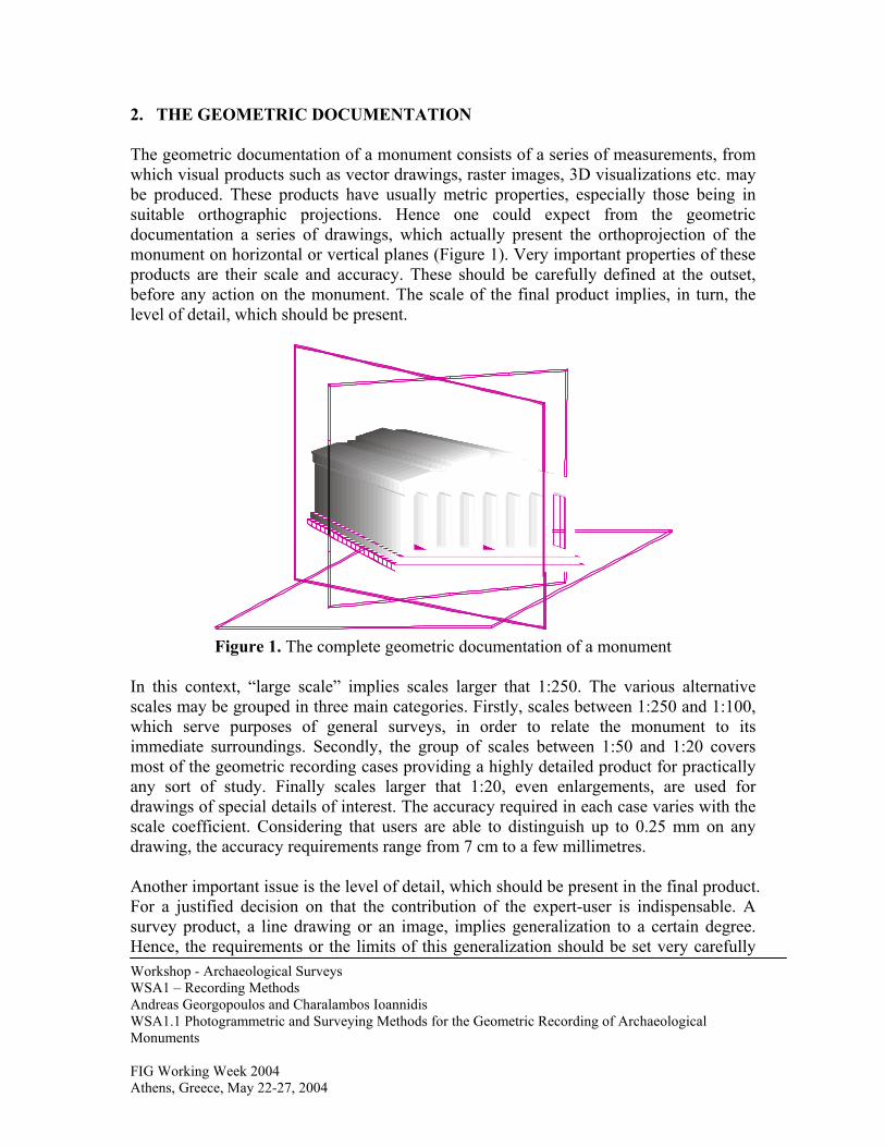
2. THE GEOMETRIC DOCUMENTATION The geometric documentation of a monument consists of a series of measurements, from which visual products such as vector drawings, raster images, 3D visualizations etc. may be produced. These products have usually metric properties, especially those being in suitable orthographic projections. Hence one could expect from the geometric documentation a series of drawings, which actually present the orthoprojection of the monument on horizontal or vertical planes (Figure 1). Very important properties of these products are their scale and accuracy. These should be carefully defined at the outset, before any action on the monument. The scale of the final product implies, in turn, the level of detail, which should be present.
Figure 1. The complete geometric documentation of a monument
In this context, “large scale” implies scales larger that 1:250. The various alternative scales may be grouped in three main categories. Firstly, scales between 1:250 and 1:100, which serve purposes of general surveys, in order to relate the monument to its immediate surroundings. Secondly, the group of scales between 1:50 and 1:20 covers most of the geometric recording cases providing a highly detailed product for practically any sort of study. Finally scales larger that 1:20, even enlargements, are used for drawings of special details of interest. The accuracy required in each case varies with the scale coefficient. Considering that users are able to distinguish up to 0.25 mm on any drawing, the accuracy requirements range from 7 cm to a few millimetres.
Workshop - Archaeological Surveys WSA1 – Recording Methods Andreas Georgopoulos and Charalambos Ioannidis WSA1.1 Photogrammetric and Surveying Methods for the Geometric Recording of Archaeological Monuments FIG Working Week 2004 Athens, Greece, May 22-27, 2004
Another important issue is the level of detail, which should be present in the final product. For a justified decision on that the contribution of the expert-user is indispensable. A survey product, a line drawing or an image, implies generalization to a certain degree. Hence, the requirements or the limits of this generalization should be set very carefully
Workshop - Archaeological Surveys WSA1 – Recording Methods Andreas Georgopoulos and Charalambos Ioannidis WSA1.1 Photogrammetric and Surveying Methods for the Geometric Recording of Archaeological Monuments FIG Working Week 2004 Athens, Greece, May 22-27, 2004
and always in co-operation with the architect, who already has deep knowledge of the monument (Ioannidis et al, 1997). For the geometric recording several surveying methods may be applied, ranging from the simple topometric methods to the elaborated contemporary surveying and photogrammetric methods. Traditionally, for reasons related to financial restrictions and to “scientific responsibilities”, simple topometric methods were the preferred ones. However, the negative experiences from the application of these methods, the technological advancements in the field of surveying and photogrammetry and the inevitable international trends have imposed a complete change in this mentality. Today in geometric documentation of monuments the following methods are applied:
• Simple topometric methods for partially or totally uncontrolled surveys • Surveying and photogrammetric methods for completely controlled surveys
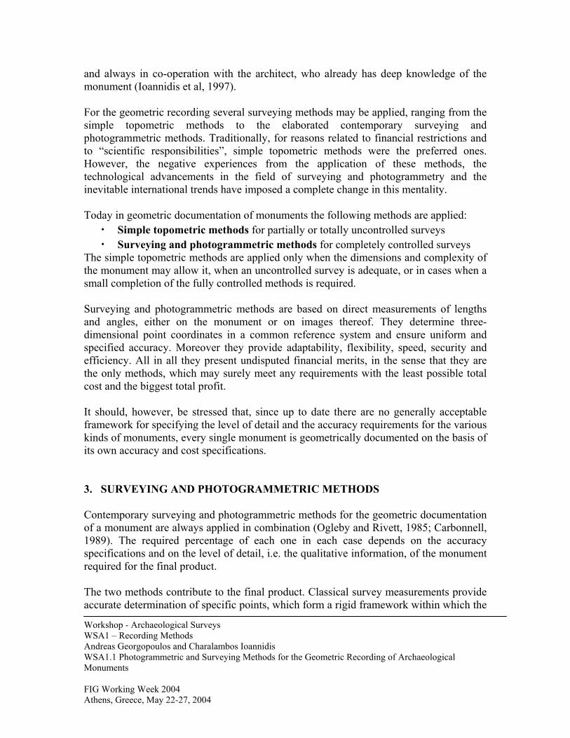
The simple topometric methods are applied only when the dimensions and complexity of the monument may allow it, when an uncontrolled survey is adequate, or in cases when a small completion of the fully controlled methods is required. Surveying and photogrammetric methods are based on direct measurements of lengths and angles, either on the monument or on images thereof. They determine three-dimensional point coordinates in a common reference system and ensure uniform and specified accuracy. Moreover they provide adaptability, flexibility, speed, security and efficiency. All in all they present undisputed financial merits, in the sense that they are the only methods, which may surely meet any requirements with the least possible total cost and the biggest total profit. It should, however, be stressed that, since up to date there are no generally acceptable framework for specifying the level of detail and the accuracy requirements for the various kinds of monuments, every single monument is geometrically documented on the basis of its own accuracy and cost specifications. 3. SURVEYING AND PHOTOGRAMMETRIC METHODS Contemporary surveying and photogrammetric methods for the geometric documentation of a monument are always applied in combination (Ogleby and Rivett, 1985; Carbonnell, 1989). The required percentage of each one in each case depends on the accuracy specifications and on the level of detail, i.e. the qualitative information, of the monument required for the final product. The two methods contribute to the final product. Classical survey measurements provide accurate determination of specific points, which form a rigid framework within which the
monument details from the photogrammetric survey are being placed (Figure 2). This framework provides strong interrelations of the measured points in 3D space, necessary as a base for the photogrammetric procedures.
Figure 2. Contribution of survey methods
Geodetic Framework
Photogrammetric Details
Workshop - Archaeological Surveys WSA1 – Recording Methods Andreas Georgopoulos and Charalambos Ioannidis WSA1.1 Photogrammetric and Surveying Methods for the Geometric Recording of Archaeological Monuments FIG Working Week 2004 Athens, Greece, May 22-27, 2004
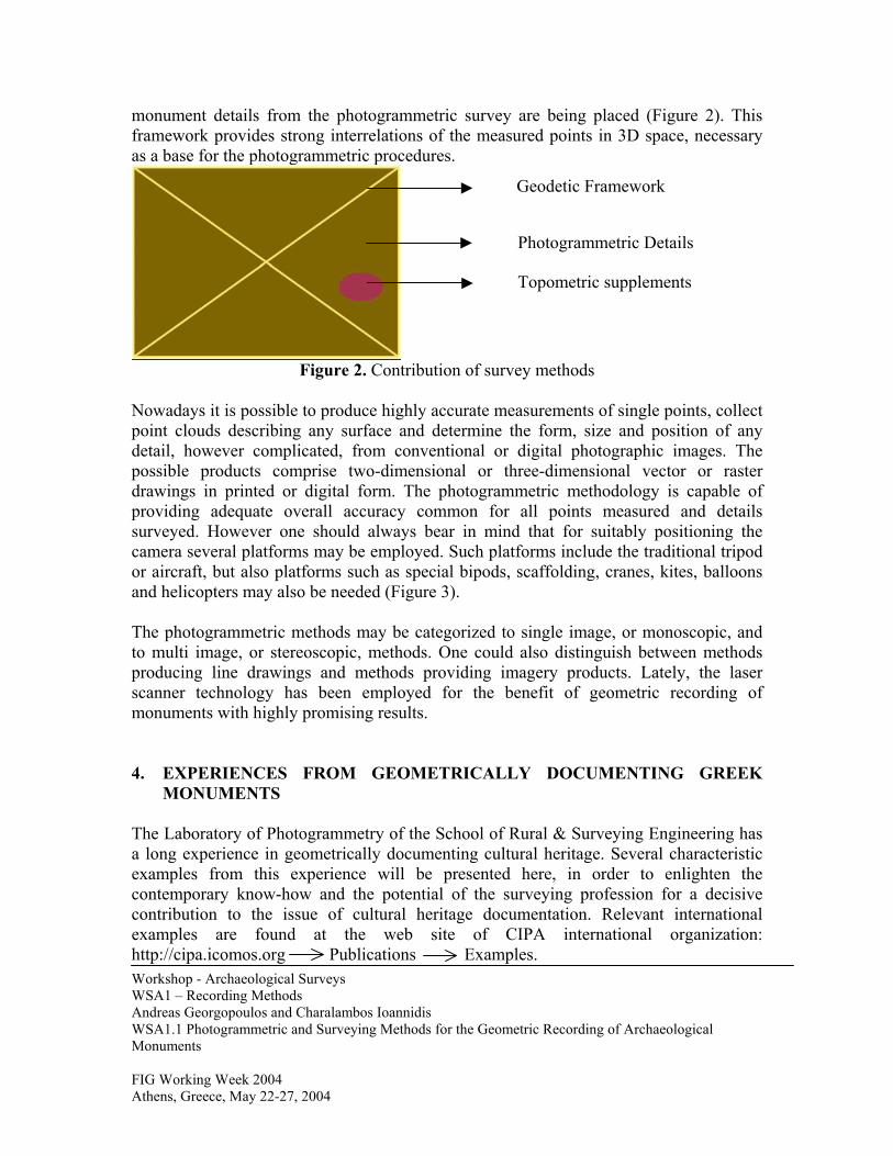
Nowadays it is possible to produce highly accurate measurements of single points, collect point clouds describing any surface and determine the form, size and position of any detail, however complicated, from conventional or digital photographic images. The possible products comprise two-dimensional or three-dimensional vector or raster drawings in printed or digital form. The photogrammetric methodology is capable of providing adequate overall accuracy common for all points measured and details surveyed. However one should always bear in mind that for suitably positioning the camera several platforms may be employed. Such platforms include the traditional tripod or aircraft, but also platforms such as special bipods, scaffolding, cranes, kites, balloons and helicopters may also be needed (Figure 3). The photogrammetric methods may be categorized to single image, or monoscopic, and to multi image, or stereoscopic, methods. One could also distinguish between methods producing line drawings and methods providing imagery products. Lately, the laser scanner technology has been employed for the benefit of geometric recording of monuments with highly promising results. 4. EXPERIENCES FROM GEOMETRICALLY DOCUMENTING GREEK
MONUMENTS The Laboratory of Photogrammetry of the School of Rural & Surveying Engineering has a long experience in geometrically documenting cultural heritage. Several characteristic examples from this experience will be presented here, in order to enlighten the contemporary know-how and the potential of the surveying profession for a decisive contribution to the issue of cultural heritage documentation. Relevant international examples are found at the web site of CIPA international organization: http://cipa.icomos.org Publications Examples.
Topometric supplements
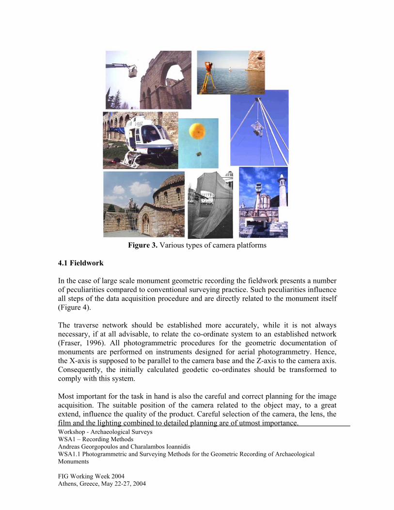
Figure 3. Various types of camera platforms
4.1 Fieldwork In the case of large scale monument geometric recording the fieldwork presents a number of peculiarities compared to conventional surveying practice. Such peculiarities influence all steps of the data acquisition procedure and are directly related to the monument itself (Figure 4). The traverse network should be established more accurately, while it is not always necessary, if at all advisable, to relate the co-ordinate system to an established network (Fraser, 1996). All photogrammetric procedures for the geometric documentation of monuments are performed on instruments designed for aerial photogrammetry. Hence, the X-axis is supposed to be parallel to the camera base and the Z-axis to the camera axis. Consequently, the initially calculated geodetic co-ordinates should be transformed to comply with this system.
Workshop - Archaeological Surveys WSA1 – Recording Methods Andreas Georgopoulos and Charalambos Ioannidis WSA1.1 Photogrammetric and Surveying Methods for the Geometric Recording of Archaeological Monuments FIG Working Week 2004 Athens, Greece, May 22-27, 2004
Most important for the task in hand is also the careful and correct planning for the image acquisition. The suitable position of the camera related to the object may, to a great extend, influence the quality of the product. Careful selection of the camera, the lens, the film and the lighting combined to detailed planning are of utmost importance.
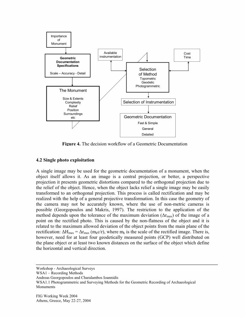
Importanceof
Monument
GeometricDocumentationSpecifications
Scale – Accuracy - Detail
The Monument
Size & ExtentsComplexity
ReliefPosition
Surroundingsetc
Selectionof MethodTopometricGeodetic
Photogrammetric
Availableinstrumentation
CostTime
Selection of Instrumentation
Geometric DocumentationFast & Simple
General
Detailed
4.2 Single p A single imaobject itselfprojection itthe relief of transformed realized withthe camera possible (Gmethod depepoint on therelated to therectification:however, nethe plane obthe horizonta
Workshop - ArWSA1 – RecoAndreas GeorgWSA1.1 PhotoMonuments FIG Working WAthens, Greece
Figure 4. The decision workflow of a Geometric Documentation
hoto exploitation
ge may be used for the geometric documentation of a monument, when the allows it. As an image is a central projection, or better, a perspective presents geometric distortions compared to the orthogonal projection due to the object. Hence, when the object lacks relief a single image may be easily to an orthogonal projection. This process is called rectification and may be the help of a general projective transformation. In this case the geometry of may not be accurately known, where the use of non-metric cameras is
eorgopoulos and Makris, 1997). The restriction to the application of the nds upon the tolerance of the maximum deviation (∆rmax) of the image of a rectified photo. This is caused by the non-flatness of the object and it is maximum allowed deviation of the object points from the main plane of the ∆Hmax = ∆rmax (mkc/r), where mk is the scale of the rectified image. There is, ed for at least four geodetically measured points (GCP) well distributed on ject or at least two known distances on the surface of the object which define l and vertical direction.
chaeological Surveys rding Methods opoulos and Charalambos Ioannidis grammetric and Surveying Methods for the Geometric Recording of Archaeological
eek 2004 , May 22-27, 2004
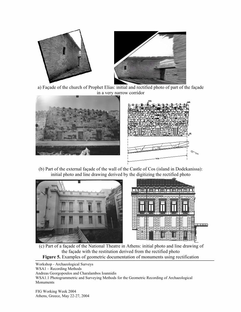
a) Façade of the church of Prophet Elias: initial and rectified photo of part of the façade
in a very narrow corridor
(b) Part of the external façade of the wall of the Castle of Cos (island in Dodekanissa): initial photo and line drawing derived by the digitizing the rectified photo
(c) Part of a façade of the National Theatre in Athens: initial photo and line drawing of
the façade with the restitution derived from the rectified photo Figure 5. Examples of geometric documentation of monuments using rectification
Workshop - Archaeological Surveys WSA1 – Recording Methods Andreas Georgopoulos and Charalambos Ioannidis WSA1.1 Photogrammetric and Surveying Methods for the Geometric Recording of Archaeological Monuments FIG Working Week 2004 Athens, Greece, May 22-27, 2004
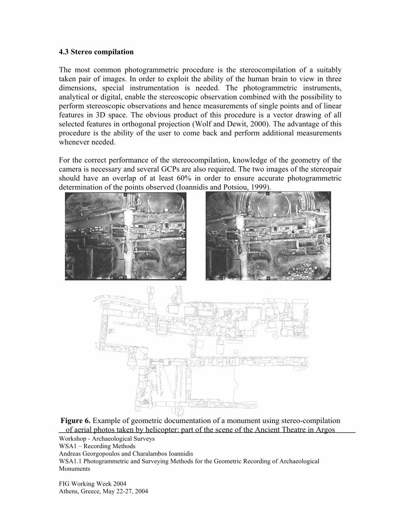
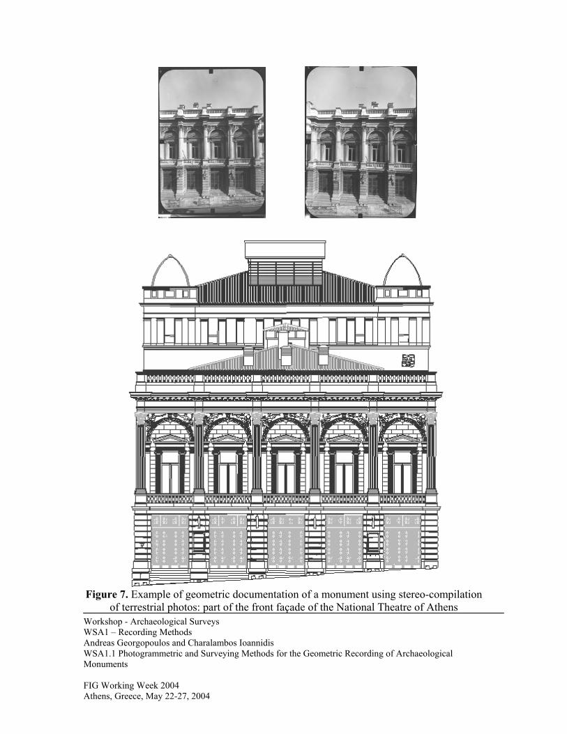
4.3 Stereo compilation The most common photogrammetric procedure is the stereocompilation of a suitably taken pair of images. In order to exploit the ability of the human brain to view in three dimensions, special instrumentation is needed. The photogrammetric instruments, analytical or digital, enable the stereoscopic observation combined with the possibility to perform stereoscopic observations and hence measurements of single points and of linear features in 3D space. The obvious product of this procedure is a vector drawing of all selected features in orthogonal projection (Wolf and Dewit, 2000). The advantage of this procedure is the ability of the user to come back and perform additional measurements whenever needed. For the correct performance of the stereocompilation, knowledge of the geometry of the camera is necessary and several GCPs are also required. The two images of the stereopair should have an overlap of at least 60% in order to ensure accurate photogrammetric determination of the points observed (Ioannidis and Potsiou, 1999).
Workshop - Archaeological Surveys WSA1 – Recording Methods Andreas Georgopoulos and Charalambos Ioannidis WSA1.1 Photogrammetric and Surveying Methods for the Geometric Recording of Archaeological Monuments FIG Working Week 2004 Athens, Greece, May 22-27, 2004
Figure 6. Example of geometric documentation of a monument using stereo-compilation
of aerial photos taken by helicopter: part of the scene of the Ancient Theatre in Argos
Workshop - Archaeological Surveys WSA1 – Recording Methods Andreas Georgopoulos and Charalambos Ioannidis WSA1.1 Photogrammetric and Surveying Methods for the Geometric Recording of Archaeological Monuments FIG Working Week 2004 Athens, Greece, May 22-27, 2004
Figure 7. Example of geometric documentation of a monument using stereo-compilation of terrestrial photos: part of the front façade of the National Theatre of Athens
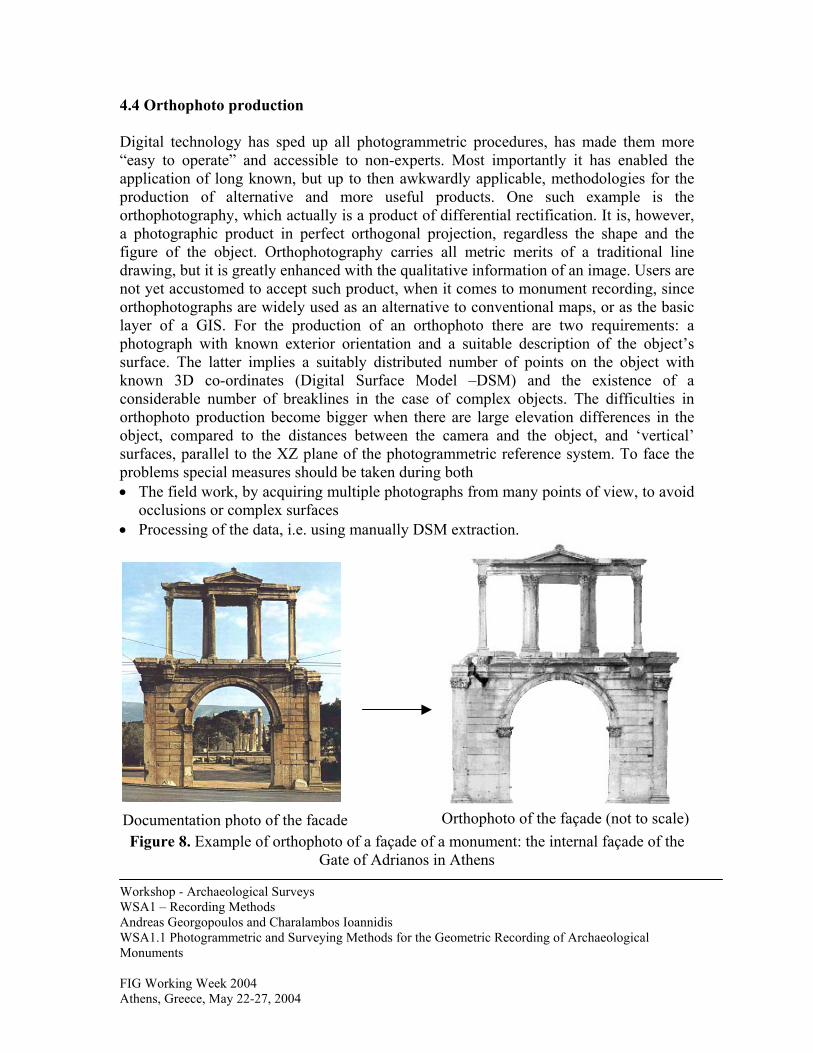
4.4 Orthophoto production Digital technology has sped up all photogrammetric procedures, has made them more “easy to operate” and accessible to non-experts. Most importantly it has enabled the application of long known, but up to then awkwardly applicable, methodologies for the production of alternative and more useful products. One such example is the orthophotography, which actually is a product of differential rectification. It is, however, a photographic product in perfect orthogonal projection, regardless the shape and the figure of the object. Orthophotography carries all metric merits of a traditional line drawing, but it is greatly enhanced with the qualitative information of an image. Users are not yet accustomed to accept such product, when it comes to monument recording, since orthophotographs are widely used as an alternative to conventional maps, or as the basic layer of a GIS. For the production of an orthophoto there are two requirements: a photograph with known exterior orientation and a suitable description of the object’s surface. The latter implies a suitably distributed number of points on the object with known 3D co-ordinates (Digital Surface Model –DSM) and the existence of a considerable number of breaklines in the case of complex objects. The difficulties in orthophoto production become bigger when there are large elevation differences in the object, compared to the distances between the camera and the object, and ‘vertical’ surfaces, parallel to the XZ plane of the photogrammetric reference system. To face the problems special measures should be taken during both
The field work, by acquiring multiple photographs from many points of view, to avoid occlusions or complex surfaces
•
• Processing of the data, i.e. using manually DSM extraction.
Orthophoto of the façade (not to scale)
Documentation photo of the facadeWorkshop - Archaeological Surveys WSA1 – Recording Methods Andreas Georgopoulos and Charalambos Ioannidis WSA1.1 Photogrammetric and Surveying Methods for the Geometric Recording of Archaeological Monuments FIG Working Week 2004 Athens, Greece, May 22-27, 2004
Figure 8. Example of orthophoto of a façade of a monument: the internal façade of the Gate of Adrianos in Athens
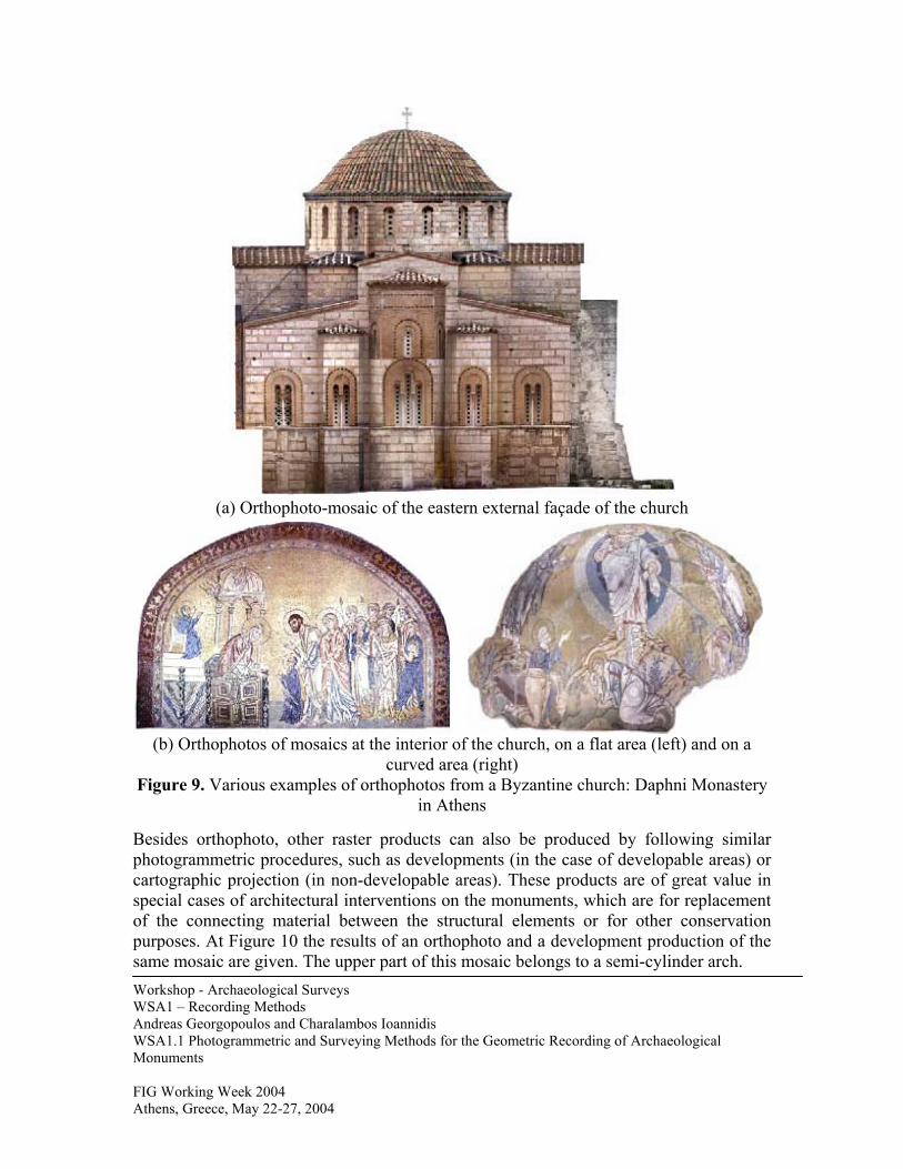
(a) Orthophoto-mosaic of the eastern external façade of the church
(b) Orthophotos of mosaics at the interior of the church, on a flat area (left) and on a
curved area (right) Figure 9. Various examples of orthophotos from a Byzantine church: Daphni Monastery
in Athens Besides orthophoto, other raster products can also be produced by following similar photogrammetric procedures, such as developments (in the case of developable areas) or cartographic projection (in non-developable areas). These products are of great value in special cases of architectural interventions on the monuments, which are for replacement of the connecting material between the structural elements or for other conservation purposes. At Figure 10 the results of an orthophoto and a development production of the same mosaic are given. The upper part of this mosaic belongs to a semi-cylinder arch. Workshop - Archaeological Surveys WSA1 – Recording Methods Andreas Georgopoulos and Charalambos Ioannidis WSA1.1 Photogrammetric and Surveying Methods for the Geometric Recording of Archaeological Monuments FIG Working Week 2004 Athens, Greece, May 22-27, 2004

Workshop - Archaeological Surveys WSA1 – Recording Methods Andreas Georgopoulos and Charalambos Ioannidis WSA1.1 Photogrammetric and Surveying Methods for the Geometric Recording of Archaeological Monuments FIG Working Week 2004 Athens, Greece, May 22-27, 2004
Ortho-projection of a mosaic representing a saint Development of a mosaic of a saint
Figure 10. Photogrammetric products in raster format of non-flat developable surfaces
4.5 Special Problems In the course of large-scale monument geometric recording one will be confronted with a number of problems. Firstly, the inability of the commercial photogrammetric instruments to accommodate the non-conventional co-ordinate systems has already been mentioned. Another problem is the difficulty of the algorithms of automatic DTM extraction to give reliable and accurate results on terrestrial stereopairs, with facades of monuments etc (Ioannidis et al, 2001). The objects are very complicated. The variety of different architectural elements and ornaments add complicated surfaces in the object, which demand special treatment, both in the stage of data acquisition and during data processing. Moreover, in order to ensure the necessary large image scales, the taking distances should be small. This is an additional problem, as it requires a larger number of images and more flexible photography systems, while the space limitations around the monuments are common and make the situation worse. Frequently there is a need of taking stereopairs with a small base and convergence in the camera axes. In addition the accuracy requirements are very high, a fact which makes things worse (Ioannidis et al, 2001).
Workshop - Archaeological Surveys WSA1 – Recording Methods Andreas Georgopoulos and Charalambos Ioannidis WSA1.1 Photogrammetric and Surveying Methods for the Geometric Recording of Archaeological Monuments FIG Working Week 2004 Athens, Greece, May 22-27, 2004
Finally, the large relief variations combined with the large image scales present perhaps the most serious problem, which leads to difficulties in image orientation adjustments, in stereo viewing and in the overall accuracy of the photogrammetric adjustments. All these problems may be confronted with various actions which have been tested in practice. 5. FURTHER POSSIBILITIES The geometric documentation methods described in the preceding sections provide useful alternative recording products, which have gradually complemented the traditional line drawings. However, those products also provide the necessary raw material for further exploitation. Two main possibilities have already been tested and are gradually gaining acceptance. Firstly, the use of orthophotography as a basic layer for an information system, related to the monument. In this way the Archaeological Spatial Information Systems (ASIS) have been created, containing and managing specialized information and relating it to the specific parts of the monument. Secondly, the technological advancements have enabled the three dimensional visualizations of the monuments on the computer screens. The compilation of 3D models of archaeological monuments is considerably facilitated by the usage of dense point clouds, which are created by the use of terrestrial laser scanners. Their combined use with photogrammetric procedures, such as the production of orthophotos, allows the realistic 3D representation of complex monuments (i.e. sculptures). In this context virtual reality tours have been created for simple or more complex monuments. This ability has greatly contributed to the thorough study of the monuments, as well as to the creation of virtual visits. REFERENCES Carbonnell, M., 1989. Photogrammetry Applied to Surveys of Monuments and Historic
Centres. ICCROM, Rome. Georgopoulos, A., Makris, G.N., 1997. Low cost Digital Rectification on a PC.
Photogrammetric Record, 15(89): 703-714. Fraser, C.S., 1996. Chapter 9: Network design, Close range photogrammetry and
machine vision. K. Atkinson ed., Whittles, Caithness, U.K., pp. 256-279. Ioannidis, C., Pappa, P., Soile, S., Tsiligiris, H., Georgopoulos, A., 2001. Orthophoto
production comparison test for close-range applications on highly curved objects. Proceedings of CIPA 2001 International Symposium, Potsdam, Germany.
Workshop - Archaeological Surveys WSA1 – Recording Methods Andreas Georgopoulos and Charalambos Ioannidis WSA1.1 Photogrammetric and Surveying Methods for the Geometric Recording of Archaeological Monuments FIG Working Week 2004 Athens, Greece, May 22-27, 2004
Ioannidis, C., Potsiou, 1999. Detailed Restitution and Representation of the Seaward Castle of Chios. Proceedings of XVII CIPA International Symposium, Recife, Brazil.
Ioannidis, C., Potsiou, C., Badekas J., 1997. The use of contemporary photogrammetric procedures for the recording and documentation of large monuments and their graphic representation. Proceedings of ΧVΙ C.I.P.A. International Symposium, Goeteborg, Sweden, IAPRS vol. 31, part 5C1B, pp. 131-140.
Ogleby, C., Rivett, L., 1985. Handbook of Heritage Photogrammetry. Australian Heritage Commission Special Australian Heritage Publication No 4, Canberra.
U.N.E.S.C.O., 1972. Photogrammetry applied to the survey of Historic Monuments, of Sites and to Archaeology. UNESCO editions.
Wolf, P., Dewit, B., 2000. Elements of photogrammetry. McGraw-Hill, New York. BIOGRAPHICAL NOTES Andreas GEORGOPOULOS Professor at the Laboratory of Photogrammetry and Head of the School of Rural and Surveying Engineering, National Technical University of Athens (NTUA), Greece, teaching Photogrammetry, Photographic Data Acquisition, Monument Recording and Metrology. 1988-92: Secretary of ISPRS Technical Commission VI 1992-1996: Co-Chairman of WGV/5 of ISPRS Technical Commisssion V 1986-date: Member of Council of the Hellenic Society for Photogrammetry & Remote Sensing 1997-date: National Delegate of Greece for CIPA. Research interests: Terrestrial and digital Photogrammetry, non-conventional applications of digital Photogrammetry. Author or co-author of approx 75 papers in the above fields, participation in numerous local and international conferences, lectures in related seminars both in Greece and abroad. Charalambos IOANNIDIS Assistant Professor at the Lab. of Photogrammetry, School of Rural and Surveying Engineering, National Technical University of Athens (NTUA), Greece, teaching Photogrammetry and Cadastre. Until 1996 he worked at private sector. 1992-96: Co-chairman of Commission VI -WG2-‘Computer Assisted Teaching’ in ISPRS. 1997-2001: Member of the Directing Council of Hellenic Mapping and Cadastral Organization and Deputy Project Manager of the Hellenic Cadastre. His research interests focus on terrestrial Photogrammetry, aerial triangulations, digital orthophotos, applications of digital Photogrammetry on the Cadastre and GIS. He has authored 45 papers in the above fields, and has given lectures in related seminars both in Greece and abroad.
Workshop - Archaeological Surveys WSA1 – Recording Methods Andreas Georgopoulos and Charalambos Ioannidis WSA1.1 Photogrammetric and Surveying Methods for the Geometric Recording of Archaeological Monuments FIG Working Week 2004 Athens, Greece, May 22-27, 2004
CONTACTS Prof. Dr. Andreas GEORGOPOULOS Professor, National Technical University of Athens 9 Iroon Polytechniou St., Zographos GR-Athens, 15780, Greece Tel.: +302107722675, Fax: +302107722677 Email: [email protected] Dr. Charalambos IOANNIDIS Assistant Professor, National Technical University of Athens 9 Iroon Polytechniou St., Zographos GR-Athens, 15780, Greece Tel.: +302107722686, Fax: +302107722677 Email: [email protected]