PDF (3619 K)
9
Journal of Sciences, Islamic Republic of Iran 22(2): 143-151 (2011) http://jsciences.ut.ac.ir University of Tehran, ISSN 1016-1104 143 Kinematics of the Dena Fault and Its Relation to Deep-Seated Transverse Faults in Zagros Fold-Thrust Belt, Iran F. Shabani-Sefiddashti and A. Yassaghi * Department of Geology, Faculty of Sciences, Tarbiat Modares University, P.O. Box 14115-175, Tehran, Islamic Republic of Iran Received: 21 June 2010 / Revised: 22 May 2011 / Accepted: 6 August 2011 Abstract The NNW-trending Dena Fault, with 140 km length, cuts the major structures of Zagros Fold-Thrust Belt in Borujen region. The fault has divided the region in two zones, in which different structural, andmorphological features as well assedimentation and seismtectonic characteristics have developed. This study presents a new interpretation for the kinematics of Dena Fault based on field evidence. Precise field mapping and structural analysis in four structural traverses across the Dena fault zone indicates that it composes of several sub parallel surface fault segments with right-lateral strike-slip to reverse right-lateral fault mechanism. Coincidence of the Dena Fault with the T-11 aeromagnetic lineament as well as evidence on the fault activity on isopach maps from Cretaseous to Miocene time implies that the north segment of the Dena Fault has kinematics relation to this lineament. The low angle between the general trending of the mapped fault segments on the surface with the trend of the aeromagnetic lineament implies their close relationship. Therefore, it is proposed that the mapped fault segments are the Riedel shear faults of an active deep-seated strike- slip fault on the surface. In addition, the proposed kinematics for the Dena Fault is compatible with the focal mechanism of earthquakes epicentered along the fault. The result of this interpretation documents that the Dena Fault is a basement fault with right-lateral strike-slip mechanism. Keywords: High Zagros; Dena Fault; Fault geometry and kinematic; Aeromagnetic Lineament; Fault segments * Corresponding author, Tel.: +98(21)82883406, Fax: +98(21)82884435, E-mail: [email protected] Introduction The NNW-trending Dena Fault extends from the south of the Borujen city to the northwest of Yasouj city (Fig. 1). The fault crosses both the High Zagros and Folded Beltzones of Zagros from North to South. The northern portion of the fault, transversely, separates the High Zagros zone in Borujen area to different structural,
Transcript of PDF (3619 K)
Journal of Sciences, Islamic Republic of Iran 22(2): 143-151 (2011) http://jsciences.ut.ac.ir University of Tehran, ISSN 1016-1104
143
Kinematics of the Dena Fault and Its Relation to
Deep-Seated Transverse Faults in Zagros
Fold-Thrust Belt, Iran
F. Shabani-Sefiddashti and A. Yassaghi*
Department of Geology, Faculty of Sciences, Tarbiat Modares University,
P.O. Box 14115-175, Tehran, Islamic Republic of Iran
Received: 21 June 2010 / Revised: 22 May 2011 / Accepted: 6 August 2011
Abstract
The NNW-trending Dena Fault, with 140 km length, cuts the major structures of Zagros Fold-Thrust Belt in Borujen region. The fault has divided the region in two zones, in which different structural, andmorphological features as well assedimentation and seismtectonic characteristics have developed. This study presents a new interpretation for the kinematics of Dena Fault based on field evidence. Precise field mapping and structural analysis in four structural traverses across the Dena fault zone indicates that it composes of several sub parallel surface fault segments with right-lateral strike-slip to reverse right-lateral fault mechanism. Coincidence of the Dena Fault with the T-11 aeromagnetic lineament as well as evidence on the fault activity on isopach maps from Cretaseous to Miocene time implies that the north segment of the Dena Fault has kinematics relation to this lineament. The low angle between the general trending of the mapped fault segments on the surface with the trend of the aeromagnetic lineament implies their close relationship. Therefore, it is proposed that the mapped fault segments are the Riedel shear faults of an active deep-seated strike-slip fault on the surface. In addition, the proposed kinematics for the Dena Fault is compatible with the focal mechanism of earthquakes epicentered along the fault. The result of this interpretation documents that the Dena Fault is a basement fault with right-lateral strike-slip mechanism.
Keywords: High Zagros; Dena Fault; Fault geometry and kinematic; Aeromagnetic Lineament; Fault segments
* Corresponding author, Tel.: +98(21)82883406, Fax: +98(21)82884435, E-mail: [email protected]
Introduction
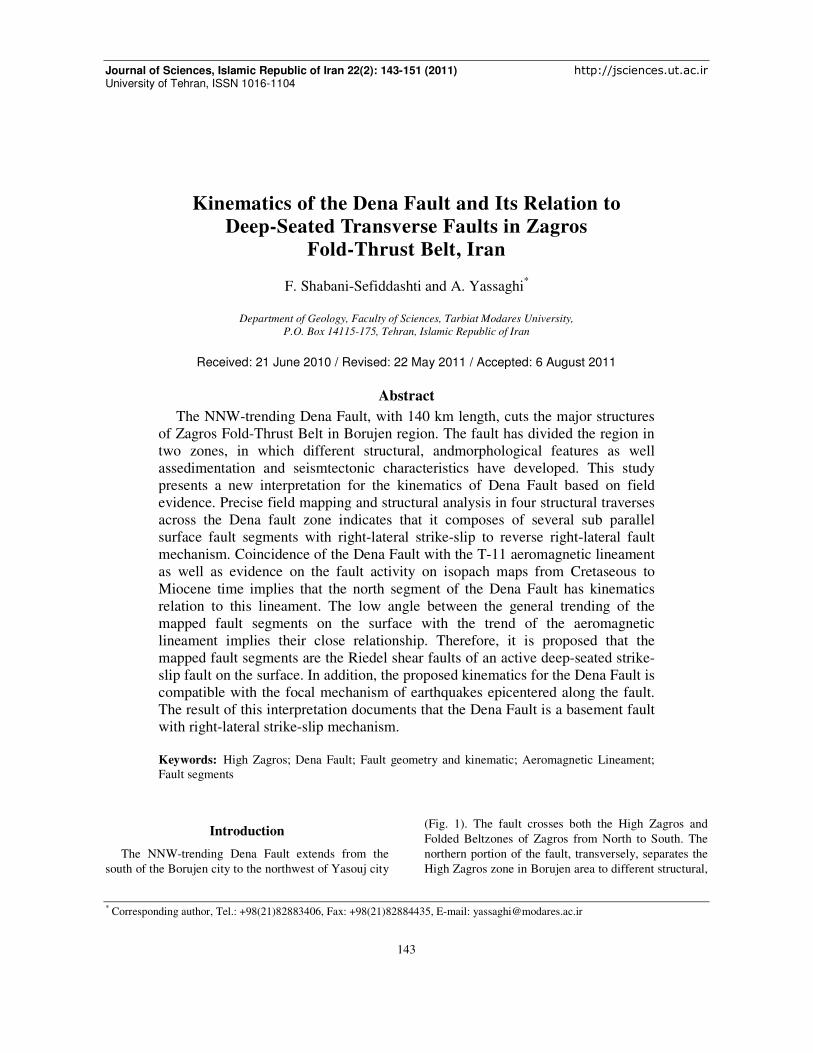
The NNW-trending Dena Fault extends from the
south of the Borujen city to the northwest of Yasouj city
(Fig. 1). The fault crosses both the High Zagros and
Folded Beltzones of Zagros from North to South. The
northern portion of the fault, transversely, separates the
High Zagros zone in Borujen area to different structural,
Vol. 22 No. 2 Spring 2011
Figure 1. Location map of the Dena Fault and the surrounding structures; (a) InterpretedLandsat image. Position of the traverse lines, perpendicular to fault trend and T
seismotectonics and geomorphology distinct.
In the aeromagnetic map of Semirom, basement in
the western part of the Dena Fault located at the depth
of ten Km while in the eastern part of the fault it is
deepened at five Km [1]. In addition
formations have exposed to the surface in the eastern
part of the fault, whereas they have buried to
five Km in the western part of the fault [2
basement and overlying cover sequence have risen to
upper structural level in the eastern part of
Fault. Previous studies show that the Dena Fault has
acted in two different mechanisms. Some authors [e.g.
3] believes that the Dena Fault have acted as a dextral
strike-slip fault in the Cambrian, but
reactived to reverse mechanism in the Qua
contrast, others [4,5] noted that the older activity of the
Dena Fault was reverse, with movement dir
toward the west, but its present activity is strike
fault. In addition, Alavi [6] noted that Dena Fault is east
Shabani-Sefiddashti and Yassaghi
144
and the surrounding structures; (a) Interpreted structural map (after f the traverse lines, perpendicular to fault trend and T-11 magnetic lineament [9
geomorphology distinct.
Semirom, basement in
located at the depth
of ten Km while in the eastern part of the fault it is
In addition, Jurassic
in the eastern
the fault, whereas they have buried to depth of
2]. Therefore,
basement and overlying cover sequence have risen to
upper structural level in the eastern part of the Dena
the Dena Fault has
in two different mechanisms. Some authors [e.g.
the Dena Fault have acted as a dextral
slip fault in the Cambrian, but have been
reactived to reverse mechanism in the Quaternary. In
that the older activity of the
Dena Fault was reverse, with movement direction
activity is strike-slip
noted that Dena Fault is east
dipping and show right-lateral reverse mechanism,
while Berberian [7] believes that activation of the Dena
fault zone resulted in major facies variations in region.
Moreover, microearthquake seismicity indicates that
slip associated with the Dena Fault is right
slip [8].
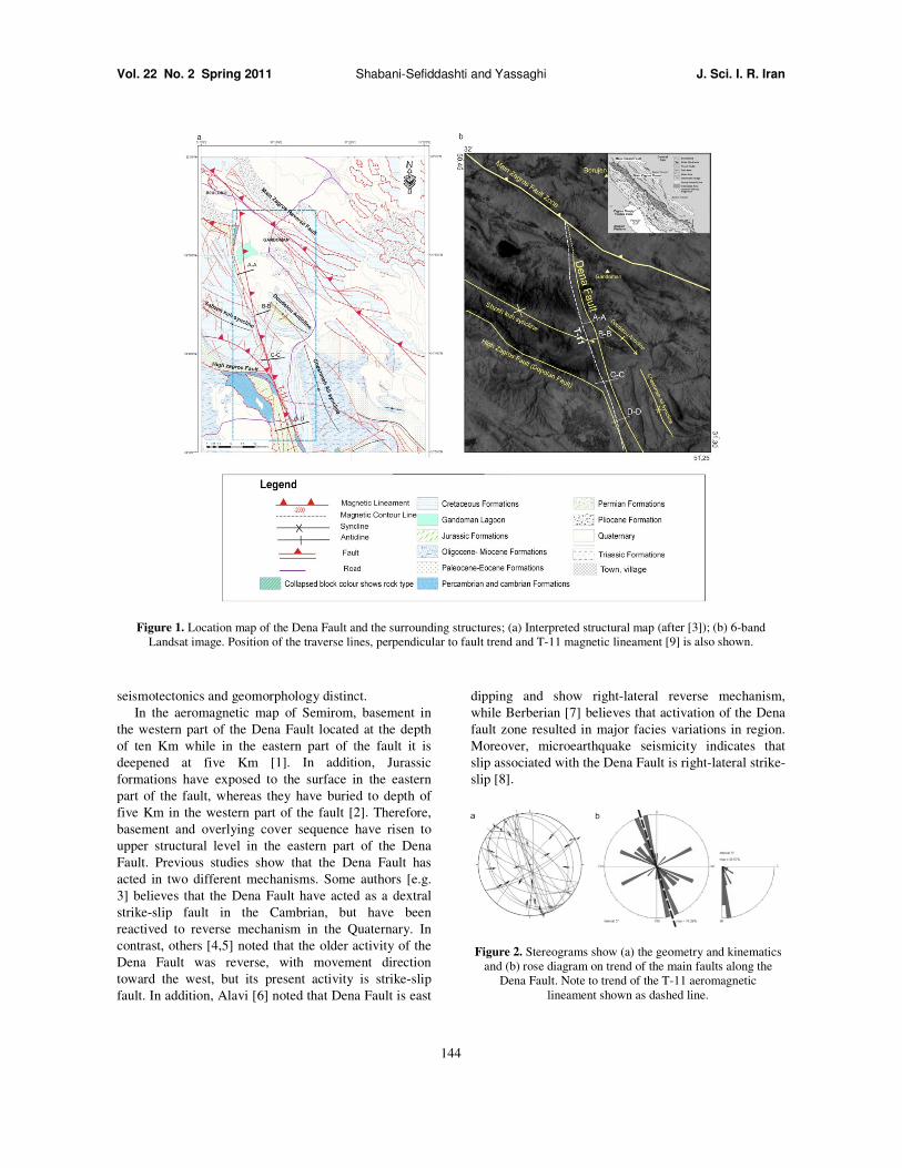
Figure 2. Stereograms show (a) the geometry and kinematics and (b) rose diagram on trend of the main faults along the
Dena Fault. Note to trend of the T-lineament shown as dashed line
J. Sci. I. R. Iran
after [3]); (b) 6-band 9] is also shown.
lateral reverse mechanism,
believes that activation of the Dena
jor facies variations in region.
Moreover, microearthquake seismicity indicates that
slip associated with the Dena Fault is right-lateral strike-
show (a) the geometry and kinematics main faults along the -11 aeromagnetic
lineament shown as dashed line.
Kinematics of the Dena Fault and Its Relation to Deep
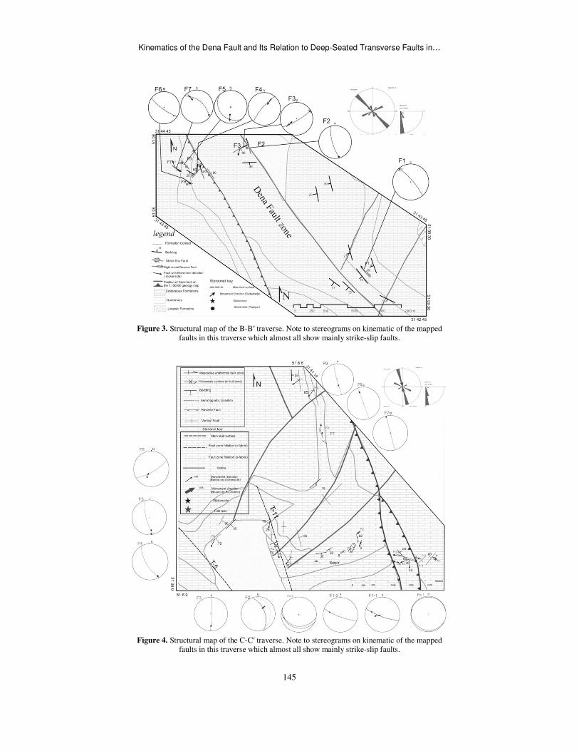
Figure 3. Structural map of the Bfaults in this traverse
Figure 4. Structural map of the Cfaults in this traverse
Kinematics of the Dena Fault and Its Relation to Deep-Seated Transverse Faults in
145
Structural map of the B-B′ traverse. Note to stereograms on kinematic of the mapped
traverse which almost all show mainly strike-slip faults.
Structural map of the C-C′ traverse. Note to stereograms on kinematic of the mapped faults in this traverse which almost all show mainly strike-slip faults.
Seated Transverse Faults in…
mapped
mapped
Vol. 22 No. 2 Spring 2011
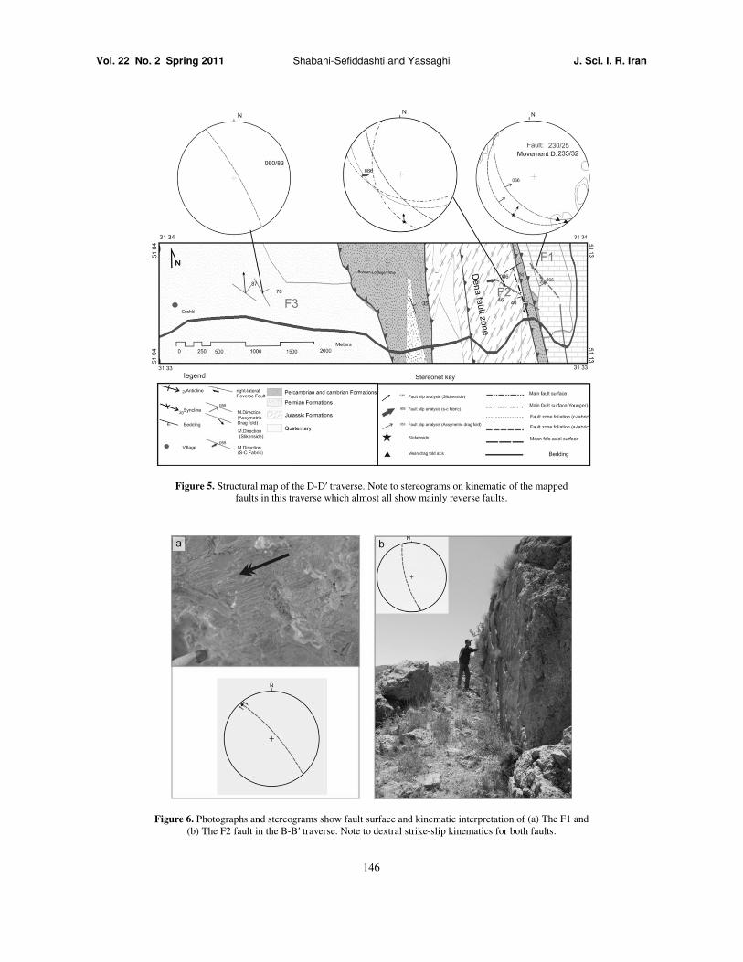
Figure 5. Structural map of the Dfaults in this traverse
Figure 6. Photographs and stereograms show fault surface and kinematic interpretation of (b) The F2 fault in the B-B
Shabani-Sefiddashti and Yassaghi
146
of the D-D′ traverse. Note to stereograms on kinematic of the mapped faults in this traverse which almost all show mainly reverse faults.
Photographs and stereograms show fault surface and kinematic interpretation of (a) The FB′ traverse. Note to dextral strike-slip kinematics for both faults.
J. Sci. I. R. Iran
mapped
The F1 and .
Kinematics of the Dena Fault and Its Relation to Deep
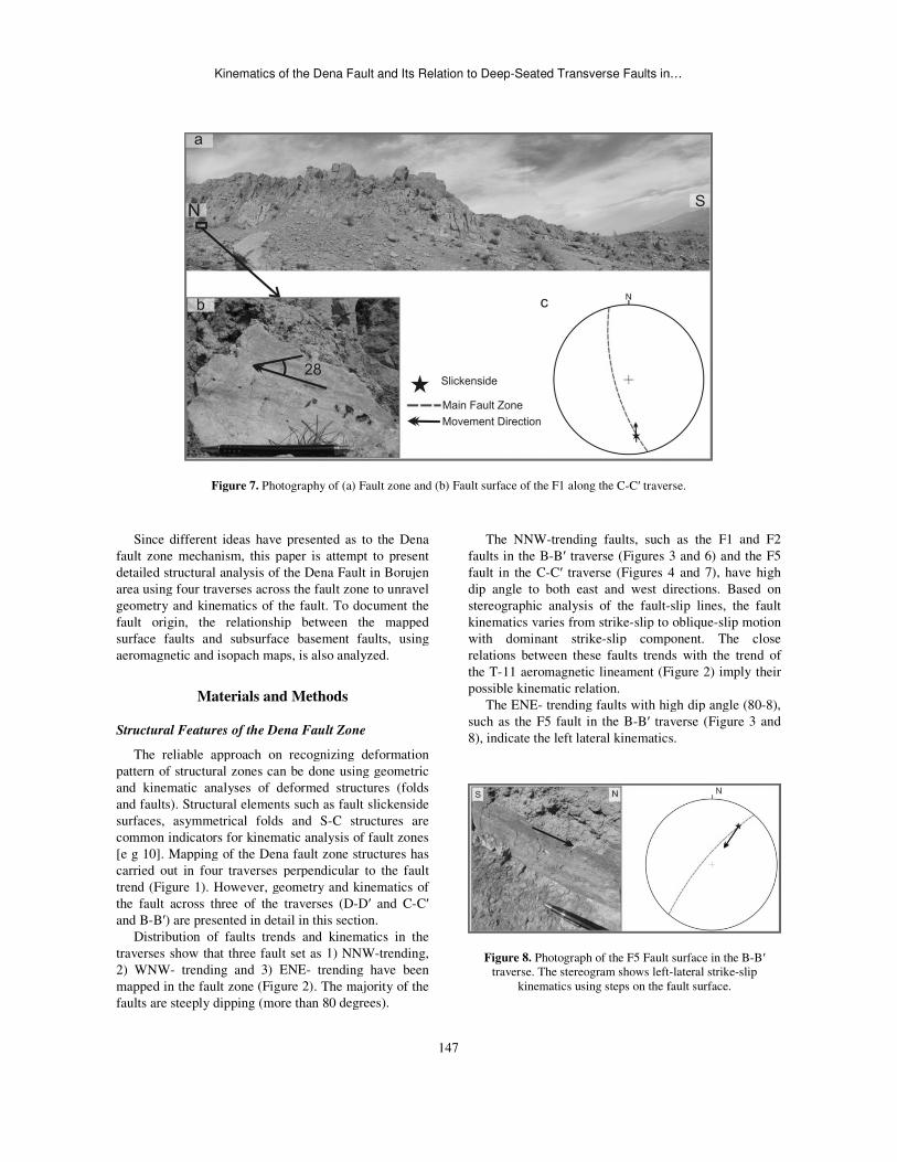
Figure 7. Photography of (a)
Since different ideas have presented as
fault zone mechanism, this paper is attempt to present
detailed structural analysis of the Dena Fault in Borujen
area using four traverses across the fault zone to unravel
geometry and kinematics of the fault. To document the
fault origin, the relationship between the mapped
surface faults and subsurface basement faults, using
aeromagnetic and isopach maps, is also analyzed
Materials and Methods
Structural Features of the Dena Fault Zone
The reliable approach on recognizing
pattern of structural zones can be done using geometric
and kinematic analyses of deformed structures
and faults). Structural elements such as fault slickenside
surfaces, asymmetrical folds and S-C structures are
common indicators for kinematic analysis of
[e g 10]. Mapping of the Dena fault zone structures has
carried out in four traverses perpendicular to the fault
trend (Figure 1). However, geometry and kinematics of
the fault across three of the traverses (D
and B-B′) are presented in detail in this section
Distribution of faults trends and kinematics in the
traverses show that three fault set as 1) NNW
2) WNW- trending and 3) ENE- trending have been
mapped in the fault zone (Figure 2). The majority
faults are steeply dipping (more than 80 degrees
Kinematics of the Dena Fault and Its Relation to Deep-Seated Transverse Faults in
147
) Fault zone and (b) Fault surface of the F1 along the C-C′ traverse
Since different ideas have presented as to the Dena
fault zone mechanism, this paper is attempt to present
detailed structural analysis of the Dena Fault in Borujen
area using four traverses across the fault zone to unravel
To document the
relationship between the mapped
subsurface basement faults, using
aeromagnetic and isopach maps, is also analyzed.
one
The reliable approach on recognizing deformation
using geometric
and kinematic analyses of deformed structures (folds
and faults). Structural elements such as fault slickenside
C structures are
common indicators for kinematic analysis of fault zones
Mapping of the Dena fault zone structures has
four traverses perpendicular to the fault
geometry and kinematics of
-D′ and C-C′
in this section.
Distribution of faults trends and kinematics in the
NNW-trending,
trending have been
The majority of the
degrees).
The NNW-trending faults, such as the F
faults in the B-B′ traverse (Figures 3
fault in the C-C′ traverse (Figures 4
dip angle to both east and west directions. Based o
stereographic analysis of the fault-
kinematics varies from strike-slip to oblique
with dominant strike-slip component. The close
relations between these faults trends with the trend of
the T-11 aeromagnetic lineament (Fi
possible kinematic relation.
The ENE- trending faults with high dip angle
such as the F5 fault in the B-B′ traverse
8), indicate the left lateral kinematics
Figure 8. Photograph of the F5 Fault surface in the traverse. The stereogram shows left-
kinematics using steps on the fault surface
Seated Transverse Faults in…
traverse.
such as the F1 and F2
3 and 6) and the F5
4 and 7), have high
angle to both east and west directions. Based on
-slip lines, the fault
slip to oblique-slip motion
slip component. The close
trends with the trend of
Figure 2) imply their
trending faults with high dip angle (80-8),
traverse (Figure 3 and
indicate the left lateral kinematics.
Fault surface in the B-B′ left-lateral strike-slip
kinematics using steps on the fault surface.
Vol. 22 No. 2 Spring 2011
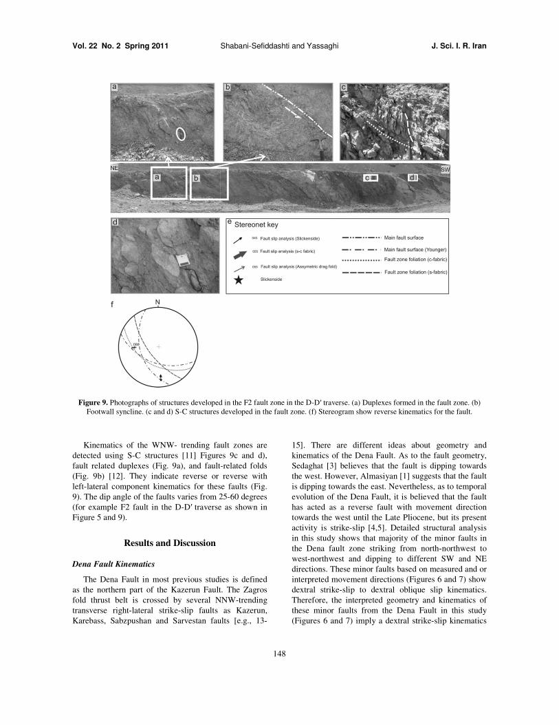
Figure 9. Photographs of structures developed in the FFootwall syncline. (c and d) S-C structures developed in the fault zone. (f) Stereogram show reverse kinematics for the fault.
Kinematics of the WNW- trending fault zones are
detected using S-C structures [11] Figures
fault related duplexes (Fig. 9a), and fault
(Fig. 9b) [12]. They indicate reverse or
left-lateral component kinematics for these faults (Fig
9). The dip angle of the faults varies from 25
(for example F2 fault in the D-D′ traverse as shown in
Figure 5 and 9).
Results and Discussion
Dena Fault Kinematics
The Dena Fault in most previous studies is defined
as the northern part of the Kazerun Fault. The Zagros
fold thrust belt is crossed by several NNW
transverse right-lateral strike-slip faults
Karebass, Sabzpushan and Sarvestan faults
Shabani-Sefiddashti and Yassaghi
148
Photographs of structures developed in the F2 fault zone in the D-D′ traverse. (a) Duplexes formed in the fC structures developed in the fault zone. (f) Stereogram show reverse kinematics for the fault.
trending fault zones are
Figures 9c and d),
and fault-related folds
reverse with
for these faults (Fig.
25-60 degrees
traverse as shown in
The Dena Fault in most previous studies is defined
Fault. The Zagros
belt is crossed by several NNW-trending
as Kazerun,
Sabzpushan and Sarvestan faults [e.g., 13-
15]. There are different ideas about geometry and
kinematics of the Dena Fault. As to the fault geometry,
Sedaghat [3] believes that the fault is dipping towards
the west. However, Almasiyan [1] suggests that the fault
is dipping towards the east. Nevertheless, as to temporal
evolution of the Dena Fault, it is believed that the
has acted as a reverse fault with movement
towards the west until the Late Pliocene, but its present
activity is strike-slip [4,5]. Detailed structural
in this study shows that majority of
the Dena fault zone striking from
west-northwest and dipping to different SW and NE
directions. These minor faults based on measured and or
interpreted movement directions (Figures
dextral strike-slip to dextral oblique slip kinematics.
Therefore, the interpreted geometry and ki
these minor faults from the Dena Fault in this study
(Figures 6 and 7) imply a dextral strike
J. Sci. I. R. Iran
traverse. (a) Duplexes formed in the fault zone. (b) C structures developed in the fault zone. (f) Stereogram show reverse kinematics for the fault.
There are different ideas about geometry and
Fault. As to the fault geometry,
believes that the fault is dipping towards
suggests that the fault
towards the east. Nevertheless, as to temporal
evolution of the Dena Fault, it is believed that the fault
with movement direction
Late Pliocene, but its present
Detailed structural analysis
in this study shows that majority of the minor faults in
north-northwest to
and dipping to different SW and NE
based on measured and or
Figures 6 and 7) show
slip to dextral oblique slip kinematics.
Therefore, the interpreted geometry and kinematics of
these minor faults from the Dena Fault in this study
imply a dextral strike-slip kinematics
Kinematics of the Dena Fault and Its Relation to Deep
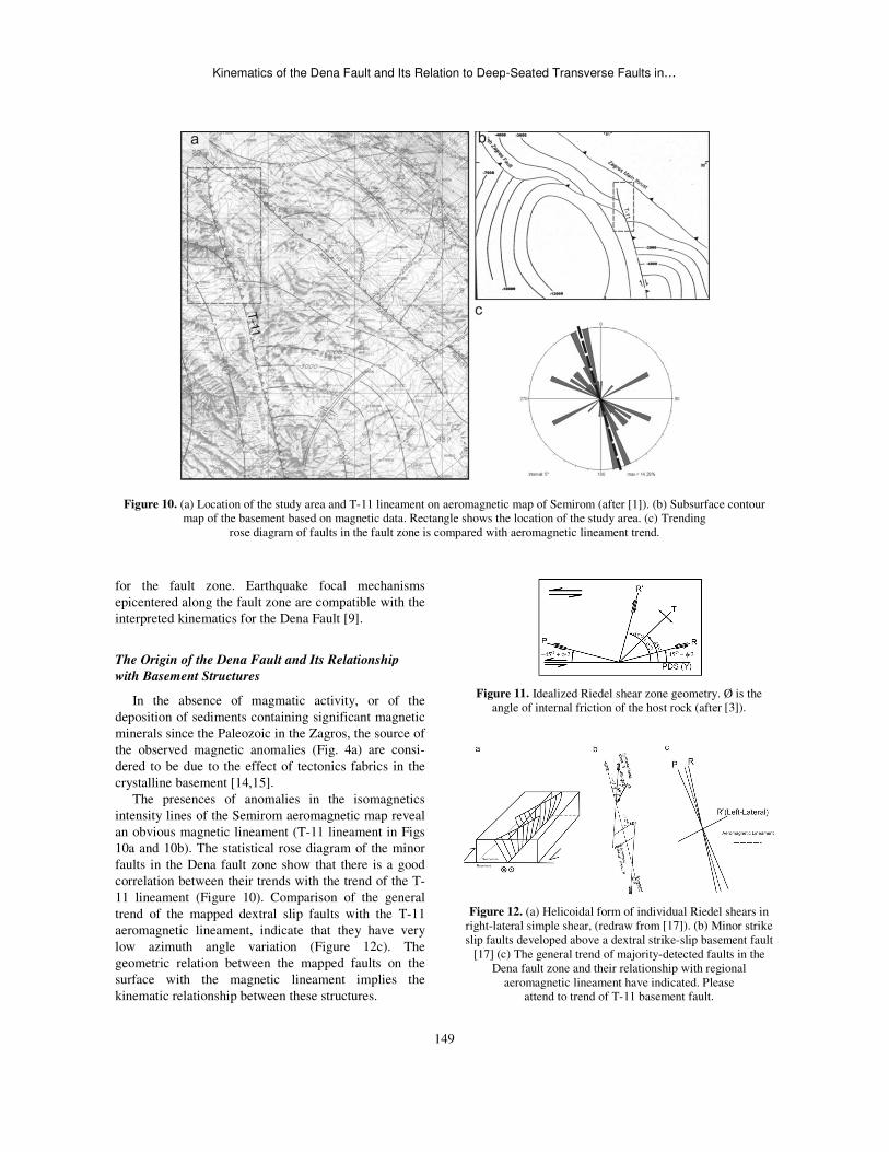
Figure 10. (a) Location of the study area and Tmap of the basement based on magnetic data. Rectangle shows the location of the study area. (c) Trending
rose diagram of faults in the fault zone is compared with
for the fault zone. Earthquake focal mechanisms
epicentered along the fault zone are compatible with the
interpreted kinematics for the Dena Fault [9
The Origin of the Dena Fault and Its Relationship
with Basement Structures
In the absence of magmatic activity, or of the
deposition of sediments containing significant magnetic
minerals since the Paleozoic in the Zagros, the source of
the observed magnetic anomalies (Fig. 4
dered to be due to the effect of tectonics
crystalline basement [14,15].
The presences of anomalies in the isomagnetics
intensity lines of the Semirom aeromagnetic map reveal
an obvious magnetic lineament (T-11 lineament in Figs
10a and 10b). The statistical rose diagram of the mino
faults in the Dena fault zone show that there is a good
correlation between their trends with the trend of the T
11 lineament (Figure 10). Comparison of the general
trend of the mapped dextral slip faults with the T
aeromagnetic lineament, indicate that they have very
low azimuth angle variation (Figure
geometric relation between the mapped faults on the
surface with the magnetic lineament implies the
kinematic relationship between these structures
Kinematics of the Dena Fault and Its Relation to Deep-Seated Transverse Faults in
149
Location of the study area and T-11 lineament on aeromagnetic map of Semirom (after [1]). (b) map of the basement based on magnetic data. Rectangle shows the location of the study area. (c) Trending
rose diagram of faults in the fault zone is compared with aeromagnetic lineament trend.
Earthquake focal mechanisms
epicentered along the fault zone are compatible with the
9].
elationship
In the absence of magmatic activity, or of the
deposition of sediments containing significant magnetic
minerals since the Paleozoic in the Zagros, the source of
4a) are consi-
fabrics in the
The presences of anomalies in the isomagnetics
intensity lines of the Semirom aeromagnetic map reveal
lineament in Figs
The statistical rose diagram of the minor
the Dena fault zone show that there is a good
correlation between their trends with the trend of the T-
Comparison of the general
trend of the mapped dextral slip faults with the T-11
at they have very
Figure 12c). The
geometric relation between the mapped faults on the
with the magnetic lineament implies the
kinematic relationship between these structures.
Figure 11. Idealized Riedel shear zone angle of internal friction of the host rock
Figure 12. (a) Helicoidal form of individual Riedel shears in right-lateral simple shear, (redraw from [slip faults developed above a dextral strike
[17] (c) The general trend of majority-detected faults in the Dena fault zone and their relationship with regional
aeromagnetic lineament have indicatedattend to trend of T-11 basement fault
Seated Transverse Faults in…
) Subsurface contour map of the basement based on magnetic data. Rectangle shows the location of the study area. (c) Trending
Idealized Riedel shear zone geometry. Ø is the angle of internal friction of the host rock (after [3]).
elicoidal form of individual Riedel shears in [17]). (b) Minor strike
slip faults developed above a dextral strike-slip basement fault detected faults in the
Dena fault zone and their relationship with regional aeromagnetic lineament have indicated. Please
basement fault.
Vol. 22 No. 2 Spring 2011 Shabani-Sefiddashti and Yassaghi J. Sci. I. R. Iran
150
Experimental studies on movement along basement
faults overlaid by viscous material like salt [16] showed
that reactivation of the basement faults could not cut the
overlaying thick material and then do not emerge to the
surface. Their reactivation, however, produces a pattern
of en echelon faults and folds on the cover sediments
[17]. Thus, the presence of the Hormoz salt overlain the
Zagros basement influences on the activity of deep-
seated basement faults such as the Dena Fault and
resulted in development of en echelon pattern of faults
on the cover surface. Continuation of the basement fault
activity at depth is resulted in development of Riedel
type shear faults as R, R′, P and T type faults on the
cover surface (Figure 11). Propagation of shears as the
Riedel shear zone may also induce local stress field
rotation, further influencing the types and geometry of
developing shear fractures [e g. 17].
Typical Riedel shears show concave upwards shape
that diverging from the basement fault and forming a
'Tulip structure'. R fractures have helicoidal shape in
three dimensions (Figure 12 A).
Comparison between detected structures in the Dena
fault zone with the presented model in figure 11 shows
that fractures in the fault zone can be proposed as the
younger orders of fractures resulted from the
continuation of the Dena Fault activity at depth. Thus,
the NNW-trending en-echelon faults (Fig. 12 b) are
compatible with R Riedel shear faults (Figs 12a and c).
Similarly, the ENE-trending faults with left-lateral slip
kinematics can be considered as R' type of Riedel shear
faults that resulted from the Dena Fault activity at depth.
A few degrees difference between the attitudes of the
mapped faults in the Dena fault zone with the presented
model in Figure 11 is interpreted to occur due to
different orders of Riedel shear fractures or inactive
rotation of structures during the younger activity.
The presented interpretation as to relationship
between the mapped structures along the Dena fault
zone and the regional aeromagnetic lineament, poses as
a basement fault, need further subsurface investigation.
Dena Fault Activity Time and Its Relationship with the
Zagros Structures
The axial surface trace of folds in Zagros fold- thrust
belt change when they cross the transverse faults [18-
20]. For instance, folds outside the Dena fault zone have
axial surface traces of 130-trending in Azimuth,
whereas when they cross the fault zone their axial
surface traces changes to Azimuth of 145 as a clockwise
sense of rotation such as the Sabzehkuh Syncline and
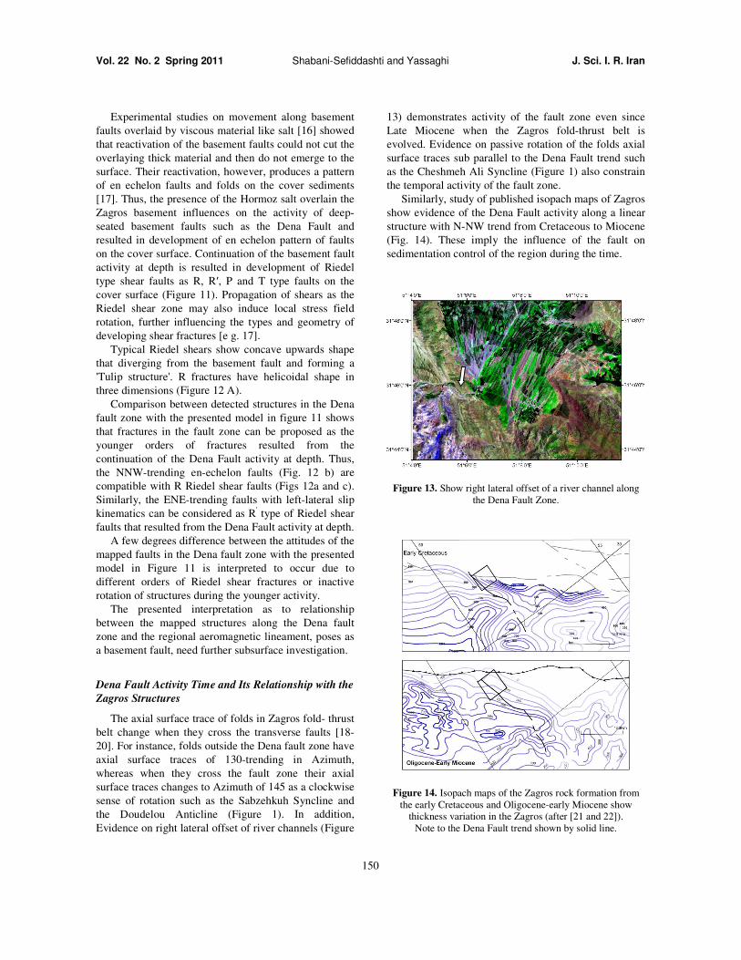
the Doudelou Anticline (Figure 1). In addition,
Evidence on right lateral offset of river channels (Figure
13) demonstrates activity of the fault zone even since
Late Miocene when the Zagros fold-thrust belt is
evolved. Evidence on passive rotation of the folds axial
surface traces sub parallel to the Dena Fault trend such
as the Cheshmeh Ali Syncline (Figure 1) also constrain
the temporal activity of the fault zone.
Similarly, study of published isopach maps of Zagros
show evidence of the Dena Fault activity along a linear
structure with N-NW trend from Cretaceous to Miocene
(Fig. 14). These imply the influence of the fault on
sedimentation control of the region during the time.
Figure 13. Show right lateral offset of a river channel along the Dena Fault Zone.
Figure 14. Isopach maps of the Zagros rock formation from the early Cretaceous and Oligocene-early Miocene show
thickness variation in the Zagros (after [21 and 22]). Note to the Dena Fault trend shown by solid line.
Kinematics of the Dena Fault and Its Relation to Deep-Seated Transverse Faults in…
151
In conclusions, detailed field mapping integrated
with satellite images of the region show that, in addition
to compression activity, the Dena Fault has strike-slip
movement. Evidence, such as right lateral offset of river
channels and clockwise rotation of the west flank of the
Doudlo anticline and its displacement along the fault
indicate the younger strike-slip mechanism for the Dena
Fault. Coincidence of the Dena Fault trend with the T-
11 magnetic lineament as well as evidence of the Dena
Fault activity, on the isopach maps from Cretaceous to
Miocene, show the fault is a deep-seated basement
structure. The low angle between the general trend of
the mapped faults in the Dena Fault zone with this
magnetic lineament imply that these fault were more
likely developed as Riedel shear fractures resulted from
a basement fault activity on the surface. The presence of
the Hormoz salt overlain the Zagros basement though
prevent the influence of the Dena Fault on surface but
causes development of younger Riedel shear fractures
with en echelon pattern on the sedimentary cove
Comparison of experimentally pattern of such faults
with mapped faults in the Dena fault zone shows the
NNW- trending faults are R and P type faults while
ENE-trending faults are R' type. Coincidence of the
Dena Fault kinematics with mechanism of earthquakes
epicentered along of the fault zone confirms the
basement origin and that of right-lateral kinematics of
the Dena Fault since Cretaceous.
References
1. Almasiyan M. Tectonics and seismotectonics of Dena-Zagros tear zone in the Borujen Area, M Sc Thesis, Azad University, Tehran, 184 p. (1992).
2. McQuarrie N. Crustal scale geometry of the Zagros fold-thrust belt, Iran J Struct Geol, 26 519–535 (2004).
3. Sedaghat, M A 1, 100000 Geological map of Burujen, Geological Survey of Iran (1996).
4. Authemayou C., Bellier, O., Chardon, D., Malekzad, Z., and Abbassi, M Role of the Kazerun fault system in active deformation of the Zagros fold- and- thrust- belt (Iran). C
R Geoscience, 337: 539-545 (2005). 5. Authemayou C., Chardon, D., and Bellier, O. Late
Cenozoic partitioning of oblique plate convergence in the Zagros fold-and thrust belt (Iran). Tectonics, 25: 1-21 (2006).
6. Alavi M., Geological map of Borujen. Geological survey of Iran, scale 1.250000 (1977).
7. Berberian M., and King G.C.P. Towards a paleogeography
and tectonic evolution of Iran. Can. J. Earth Sci, 18, 210–265 (1981).
8. Yamini-Fard F., Hatzfeld, D , Tatar, M., and Mokhtari, M. Microearthquake seismicity at the intersection between the Kazerun fault and the Main Recent Fault (Zagros, Iran). Geophys J. Int, 166: 186-196 (2006).
9. Yousefi E., and Friedberg, J.L. Aeromagnetic map of semirom. Scale 1 250000, Geological survey of Iran (1978).
10. Marshak S. and Mitra G. Basic Methods Of Structural Geology. Prentice Hall, 446p. (1988).
11. Hippert J. Are S-C structures, duplexes and conjugate shear zones different Manifestations of the same scale-invariant phenomenon Journal of Structural Geology, 21: 975-984 (1999).
12. Doblas M. Slicken side kinematic indicators Tectonophysics, 295: 187-197 (1998).
13. Hatzfeld D., Authemayou C., Van Der Beek P., Bellier O., Lave J., Oveisi B., Tatar M., Tavakoli F., Walpersdorf A., and Yamini-Fard F. The kinematics of the Zagros Mountains (Iran). Geological Society Special Publication, 330: 19-42 (2010).
14. Bahroudi A., and Talbot, C.J. The configuration of the basement beneath the Zagros basin. Journal of Petroleum
Geology, 26: 257-282 (2003). 15. Morris P. Basement structure as suggested by
aeromagnetic surveys in southwest Iran Proceedings of the Second Geological Symposium of Iran, Tehran, Iranian Geological Institute. (1977).
16. Darrell S., Ferrill, D.A. and Stamatakos, J A. Role of ductile decollement in the development of pull-apart basins: Experimental results and natural examples. Journal of Structural Geology, 21: 533–554 (1999)
17. Naylor M A , Mandl, G. and Sijpesteijin, C H K. Fault geometries in basement-induced wrench faulting under different initial stress states. Journal of Structural
Geology, 8: 737-752 (1986). 18. Yassaghi A. Integration of Land sat imagery interpretation
and geomagnetic data on verification of deep-seated transverse fault lineaments in SE Zagros, Iran. International of Remote Sensing, 27: 4529-4544 (2006).
19. Fürst M. Strike-slip faults and diapirism of the south eastern Zagros ranges. In Proceedings of Symposium on Diapirism, Bandar Abbas, 2: 149-183 (1990).
20. Hessami K., Koyi, H. A., and Talbot, C. J. The significance of strike-slip faulting in the basement of the Zagros Fold and Thrust belt. Journal of Petroleum
Geology, 24: 5-28 (2001). 21. Motiei H. Geology of Iran - volume 1: stratigraphy of
Zagros. Geological survey of Iran publications, Tehran, 556 p. (1994).
22. Sepehr M. and Cosgrove, J.W. Structural framework of the Zagros fold thrust belt, Iran. Mar. Pet. Geol, 21: 829-843 (2004).


![f 2699 CMPsy Generalized Anxiety Disorder in Adults Focus on Pregabalin.pdf 3619[1]](https://static.fdocuments.net/doc/165x107/577d25461a28ab4e1e9e6c3d/f-2699-cmpsy-generalized-anxiety-disorder-in-adults-focus-on-pregabalinpdf.jpg)