National Park Service National Register of Historic Places · National Park Service National...
29
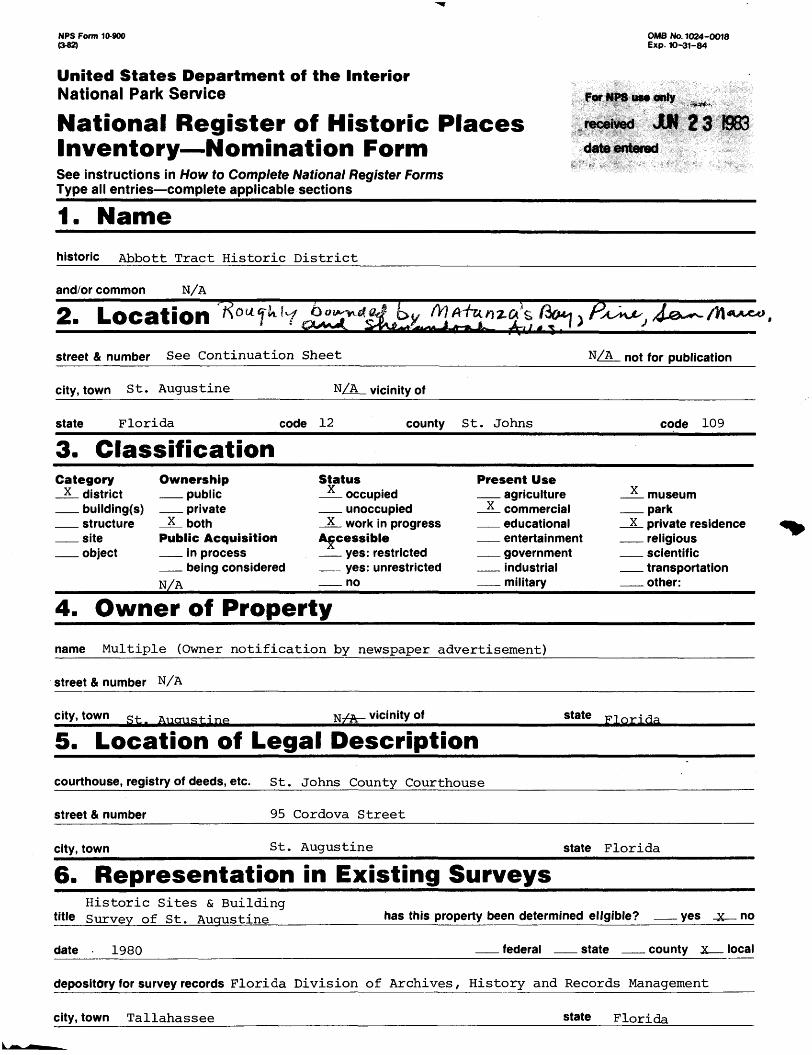
NFS Form 10-900 (342) OMB No. 1024-OO18 Exp. 10-31-84 United States Department off the Interior National Park Service National Register of Historic Places Inventory—Nomination Form See instructions in How to Complete National Register Forms Type all entries—complete applicable sections_______________ 1. Name__________________ historic Abbott Tract Historic District and/or common N/A 2. Location ^ m ™ street & number See Continuation Sheet N/A not for publication city, town St. Augustine N/A vicinity of state Florida code 12 county St. Johns code 109 3. Classification Category Ownership x district public building(s) private Structure x both site Public Acquisition object in process being considered N/A Status x occupied unoccupied X work in progress Accessible yes: restricted yes: unrestricted no Present Use agriculture x commercial educational entertainment government industrial military x museum park X private residence religious scientific transportation other: 4. Owner of Property name Multiple (Owner notification by newspaper advertisement) street & number N/A city, town st _ vicinity of state Florida 5. Location of Legal Description courthouse, registry of deeds, etc. St. Johns County Courthouse street & number 95 Cordova Street city, town St. Augustine state Florida 6. Representation in Existing Surveys Historic Sites & Building title survey of St. Augustine has this property been determined eligible? yes no date 1980 federal state county local depository for survey records Florida Division of Archives, History and Records Management city, town Tallahassee state Florida
Transcript of National Park Service National Register of Historic Places · National Park Service National...
NFS Form 10-900 (342)
OMB No. 1024-OO18 Exp. 10-31-84
United States Department off the InteriorNational Park Service
National Register of Historic Places Inventory—Nomination FormSee instructions in How to Complete National Register FormsType all entries—complete applicable sections_______________
1. Name__________________
historic Abbott Tract Historic District
and/or common N/A
2. Location^m ™
street & number See Continuation Sheet N/A not for publication
city, town St. Augustine N/A vicinity of
state Florida code 12 county St. Johns code 109
3. ClassificationCategory Ownership
x district publicbuilding(s) privateStructure x both
site Public Acquisitionobject in process
being consideredN/A
Statusx occupied
unoccupiedX work in progress
Accessibleyes: restrictedyes: unrestrictedno
Present Useagriculture
x commercialeducationalentertainmentgovernmentindustrialmilitary
x museumpark
X private residencereligiousscientifictransportationother:
4. Owner of Property
name Multiple (Owner notification by newspaper advertisement)
street & number N/A
city, town st _ vicinity of state Florida
5. Location of Legal Description
courthouse, registry of deeds, etc. St. Johns County Courthouse
street & number 95 Cordova Street
city, town St. Augustine state Florida
6. Representation in Existing SurveysHistoric Sites & Building
title survey of St. Augustine has this property been determined eligible? yes no
date 1980 federal state county local
depository for survey records Florida Division of Archives, History and Records Management
city, town Tallahassee state Florida
7. Description
Condition Check oneexcellent deteriorated unaltered
X good** <J yg f. ruins X alteredfair *' '"' ' unexposed
Check onex original site
moved date
Describe the present and original (if known) physical appearance
The Abbott Tract Historic District is a well-defined seventeen-block section of St. Augustine located north of the seventeenth century stone fortress, the Castillo de San Marcos, and south of the sixteenth century site of the Noinbre de Dios Indian mission village. San Marco Avenue, an early nineteenth century thoroughfare, and Hospital Creek form the western and eastern boundaries respectively.
Two territorial period subdivision plats comprise the Abbott Tract grid. In the 1838 plat of the Noda Concession subdivision, three thirty-foot wide streets, Clinch, Shenandoah and Joiner, ran east-west between San Marco Avenue and the creek, with one north-south street, Cleland (today Water), extending from the fort reservation to Joiner Street. The grid north of Joiner, platted in 1839 as Davis 1 Range, consisted of three similarly narrow east-west streets, Mulberry, Locust and Pine, and three north-south streets, Water, Orange (now Osceola) and Washington (today Abbott). This street plan with its seventeen irregularly-shaped blocks has remained relatively unchanged, although several streets, such as Clinch and the extension of Osceola north of Pine, have been closed as public thoroughfares. The only addition to the original plats was the ca. 1890 extension of Abbott Street one block south of Mulberry to Joiner Street. City officials changed the names of Orange and Washington Streets in the late nineteenth century to avoid duplicating other street names in the growing city. Moreover, the name of the two territorial subdivisions officially was changed by the early 1920s to Abbott Tract in honor of the principal developer of both areas.
Abbott Tract has the highest percentage of pre-1930 buildings in St. Augustine. Of the 149 buildings in the area, only 13 were constructed within the last half century. And as the first development outside the colonial city boundaries, the tract possesses the largest concentration of nineteenth century architecture in the city, with eighty of the buildings having been built between 1839 and 1899. Three residences, the 1839 Beach Cottage (fig. 11),the 1840 Joyner House, and the ca. 1861 Abbott House (fig. 10) date from the pre-Civil War period.
The area is relatively free of intrusions. Several post-World War II residences are scattered along Water Street (fig. 4) .and Osceola Street (fig. 5), but the most extensive and obvious cluster of non-conforming buildings is on San Marco Avenue, a major commercial artery north of the colonial city district (fig. 7). Moreover, the buildings as a whole have retained a high degree of integrity as over two-thirds have not been significantly altered and only two have lost their historical character through remodelings.
The general character of Abbott Tract is overwhelmingly residential, (figs. 1, 15), although seven of the pre-1930 buildings, mainly along San Marco Avenue, have been successfully and in some cases tastefully adapted for commercial purposes (fig. 6). The southernmost building in the tract. Castle Warden, functions as Ripley's Museum and has sufficient parking to keep vehicles out of the neighborhood as a whole (fig. 17).
As a result of a long period of development, Abbott Tract exhibits a diverse architectural legacy. Reflecting the mixed economic and social backgrounds of the residents, buildings in the area range from modest 1- and 1^-story frame dwellings to a grandoise and monumental 4^-story poured concrete former residence. Most buildings are small vernacular houses built to fit on the narrow, and in some cases shallow lots platted in the original subdivisions. Regardless of construction date, the most
(See Continuation Sheet)
8. Significance
Period__ prehistoric __ 1400-1499
1500-15991600-1699
JX_ 1700-1 799 _JL_ 1800-1899 _X_1900-
Specific dates
Areas of Significance — Checkarcheology-prehistoric X
x archeology-historicagriculture
_ X. architectureartcommerce X
communications
and justify belowcommunity planningconservationeconomicseducation X engineeringexploration/settlementindustry X invention
landscape architecturelawliteraturemilitarymusic philosophypolitics/government
religionsciencesculpturesocial/humanitarian theatertransportationother (specify)
C1838-1930 Builder/Architect various
Statement of Significance (in one paragraph)
The neighborhood immediately north of the colonial city and the Castillo de San Marcos, known today as Abbott Tract, was the first area outside the colonial urban center to be systematically developed and settled. Indian villages and European homesteads were situated there in the eighteenth century, and the first subdivisions in St. Augustine were platted in this section during the territorial period. Abbott Tract contains the largest concentrations of nineteenth century buildings in the city as well as some of the finest examples of Victorian era architecture, particularly on Water Street, the riverfront thoroughfare. Moreover, three of the eighteen territorial and early statehood (1821-1865) residences in St. Augustine are located in the tract. The northern section of the subdivision is noted for being one of the first post-Civil War black communities that developed outside the boundaries of the colonial city area.
During the late sixteenth and seventeenth centuries, this area served as common pastureland for the Spanish inhabitants of St. Augustine. 1 After the South Carolinians destroyed the city in 1702, the land north of the settlement was incorporated into an expanding defense system. An earthenwork barrier, the Hornabeque or Hornwork, ran from the northeast corner of Abbott Tract southwest to the banks of the San Sebastian River and comprised the second of three eighteenth century defense lines that guarded the northern approach to the city. 2 The Hornwork also provided protection for two Creek Indian villages, La Costa and Nuestra Senora de la Leche, which were located in the southern and northern halves of Abbott Tract respectively. The La Leche village, relocated there after the English destroyed the Nombre de Dios mission one-quarter mile north in 1728, was one of the more permanent aboriginal settlements around St. Augustine, as evidenced by the erection of an elaborate coquina chapel just inside the defense line near the northern end of present-day Water Street. 3 The Hispanicized Indians left St. Augustine for the Caribbean in 1763 when England gained control of the Florida colony through the Treaty of Paris.^
Although the British maintained the Hornwork during their twenty-one year rule of East Florida (1763-1784), they converted the abandoned La Leche church into a hospital. Minorcans began to settle and farm the land vacated by the Indians shortly after arriving in St. Augustine from New Smyrna in 1777. 5 A change in defense strategies in the second Spanish period (1784-1821) modified land use patterns in the area north of the Castillo. Around 1800 the Spanish governor abandoned the use of defense lines and replaced them with a defense perimeter known as the Mil y Quinientas, a cleared area extending fifteen hundred varas (Spanish yards) or three-quarters of a mile north of the city gate at St. George Street. Within this perimeter, the governors issued land grants with the stipulations that the properties be cleared of trees and undergrowth which might provide an attacker with cover and that only temporary structures made of wood or palmetto be erected. Beginning in the first decade of the nineteenth century, Governor Enrique White issued small grants, averaging about three to five acres, within the Mil y Quinietas on both sides of the Mil y Quinientas road, today known as San Marco AvenueT5 Between 1803 and 1808, the land comprising Abbott Tract awa* conveyed to five farmers: Jose Noda, a Canary Islander; Juan Garcia, a free,blacky Juan*Genopoly, a Greek; and Pedro Estopa and Juan Villalonga, both Minorcans. All tilled their plots with the exception of Juan Garcia who sold his land to Jose Noda sometime before 1821. 7
(See Continuation Sheet)
9. Major Bibliographical References
(See Continuation Sheet)
10. Geographical DataAcreage of nominated property __ _ Quadrangle nam* St. Augustine
UTM References
Quadrangle scale 1:24,000
Ul6i9l9iliol |3|3 |oi?|4 |6 |0 Zone Easting Northing
3 is lo I? b is to
B LiiJ k 3i 3l ni ? fil
loE I 1 1 7 I UJ6I9L 14 »ol 1 3 13 In 17 \Q 13 10 I
Gl . I I I . I l.ll . I . I . . I
Northing
n ol 131 3)01 vl RI ftin
in I I a.JmvldiRin
Zone Easting
D li '7 I 14 k ig[F ll 17 I J4 Ifi IQ If-
H| . II III . . I I . I .. I . . I
Verbal boundary description and justification
(See Continuation Sheet)
List all states and counties for properties overlapping state or county boundaries
state N/A_______________code N/A county N/A ______________code
state N/A code N/A county N/A code N/A
11. Form Prepared By
name/title Michael Scardaville/Larry Paarlberg, Historic Sites Specialist
organization Florida Division of Archives , History and date May 19 , 1983_____Records Management
street & number Dept. of State, The Capitol telephone (904) 487-2333
city or town Tallahassee state Florida
12. State Historic Preservation Officer CertificationThe evaluated significance of this property within the state is:
__ national __ state x local
As the designated State Historic Preservation Officer for the National Historic Preservation Act of 1966 (Public Law 89- 665), I hereby nominate this property for inclusionin the National Register and certify, that it has been evaluated according to the criteria and procedures set fortlfSy the^National Park Service.
State Historic Preservation Officer signature
title L. Ross Morrell, State Historic Preservation Officer date 2 Q, 1983
NPS Form 10-900-a 0-82)
OMB No. 1024-0018 Exp. 10-31-84
United States Department off the InteriorNational Park Service
National Register of Historic Places Inventory—Nomination Form
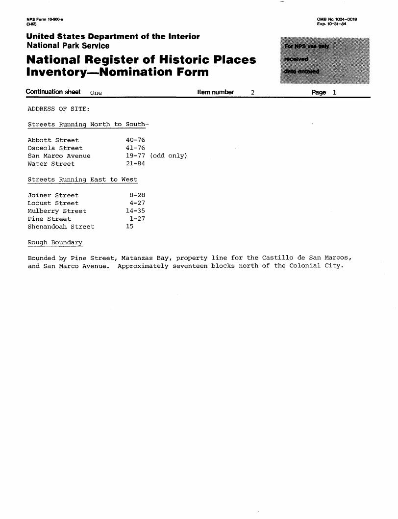
Continuation sheet one Item number Page 1
ADDRESS OF SITE:
Streets Running North to South-
Abbott Street Osceola Street San Marco Avenue Water Street
40-7641-7619-77 (odd only)21-84
Streets Running East to West
Joiner Street Locust Street Mulberry Street Pine Street Shenandoah Street
Rough Boundary
8-28 4-2714-35 1-27
15
Bounded by Pine Street, Matanzas Bay, property line for the Castillo de San Marcos, and San Marco Avenue. Approximately seventeen blocks north of the Colonial City.
NPS Form 10-900-a OMB No. 1024-0018 (3-82) Exp. 10-31-84
United States Department of the InteriorNational Park Service
National Register of Historic Places Inventory—Nomination Form
Continuation sheet Twn_________________Item number 7____________Page 1______
prominent features on the smaller residences include a one-story open or screened front porch devoid of ornamentation (figs. 1, 9, 15). The majority have gable roofs, although hip roofs are seen as well (fig. 1). Several residences exhibit details normally found on the larger buildings, including brackets, decorative balustrades, and friezes (figs. 3, 9). Several l^-story buildings form a stylistic bridge between the more modest and larger residences. Intersecting gable roofs or gable roofs with dormers predominate as do one-story porches with complementary detailing (figs. 9, 15). The 2- and 2h- story frame vernacular residences often exhibit a 2-story porch with such features as decorative balustrades, brackets, and spindle friezes (figs. 10, 11). A wrap-around porch is seen occasionally, (fig. 6) while other large residences display no significant exterior features (fig. 14).
Examples of other architectural styles are scattered throughout Abbott Tract, many of which are seen on fairly substantial buildings. The most prominent Colonial Revival buildings include the ca. 1875 (later remodeled) Abbott Mansion,(fig. 17); the 1896 George Dismuskes House, (fig. 23); and the 1906 residence at 40 Water Street. Two fine examples of Queen Anne architecture are the Beach Cottage (fig. 11), a territorial period residence remodeled in the 1890s, and the 1891 John Dismuskes House (fig. 13). Since the area was largely developed before World War I, the Mediterranean Revival and Bungalow styles were not popular here. The only Mediterranean Revival building of note is the 1924 Rodenbaugh House (fig. 22). The most elaborate building in Abbott Tract is the massive 1887 Castle Warden, a poured concrete structure designed in the Moorish Revival style.(fig. 16). Castle Warden is one of a dozen Moorish Revival buildings in St. Augustine and is the most ornate and monumental. The 4%-story building is topped with battlements and massive chimneys, with a series of rose windows below. Windows and loggia have arched heads in Tuscan and Moorish patterns. The building also exhibits decorative string courses of dentils and a trefoil pattern in the concrete balustrade. Castle Warden, which sits on an expansive lot immediately north of the fort reservation, dominates the southern entrance into the neighborhood.
Two streets in Abbott Tract merit special mention since they best represent the social and economic diversity of the tract. The buildings along Water Street, the easternmost thoroughfare, are collectively the largest and most architecturally diverse, with examples of Queen Anne, Colonial Revival, and Mediterranean Revival along its six-block course (figs. 11, 13, 14). The best examples of nineteenth century vernacular architecture also are found on Water Street as many building exhibit porches or verandas with brackets, neo-classical balustrades, and patterned shingles (fig. 10). Similar scale, set-back, street rhythm, and landscaping on the narrow thoroughfare all contribute to the cohesive character of the street,(figs. 5, 14). Osceola Street, immediately to the west, represents a different architectural and historical type in the Abbott Tract commiinity as most residences in its northernmost block were built as modest rental houses for construction workers and domestics (fig. 15). The small one-story buildings, built in the early and mid-1880s, contrast with the adjacent rambling residences on Water Street. Most have porches with a minimum of bracket work (fig. 2) and this, combined with a similarity in scale and street rhythm, gives the street its unique appeal. A series of compatible structures were built on the rear lots as well, thus creating an ambience of a closed community of buildings and inhabitants.
NPS Form 10-900-a OMB No. 1024-0018 <M2) Exp. 10-31-84
United States Department of the InteriorNational Park Service
National Register of Historic Places Inventory—Nomination Form
Continuation sheet Three_______________Item number 8____________page 1_____
The development of this prime land north of town into a residential and commercial suburb was the intention of Peter Sken Smith, a land speculator from Philadelphia who served as Brigadier General in the Florida Militia in the Second Seminole War and as board member of the Southern Life Insurance and Trust Co. of St. Augustine, one of the first banks in territorial Florida. The late 1830s in St. Augustine was a period of prosperity. The Indian war not only injected federal money into the community, but refugees also flocked from the interior to the city for protection.8 Housing consequently was in short supply, a problem which Smith hoped to remedy by opening a new residential area just north of the old city. In 1837 Smith purchased the two Noda properties, the southernmost of the Mil y Quinientas grants. In the following year, Smith surveyed and subdivided the nine-acre tract into thirty lots, two undivided blocks, and four streets. This development, bounded by the fort reservation, Joiner Street, the Road to Jacksonville (San Marco Avenue), and Hospital Creek, was called the Noda Concession.9 The future for the new subdivision was bright, especially after William H. Simmons, a local physician who helped select Tallahassee as the site for the state capital, and John C. Cleland, the local district attorney, purchased the two undivided blocks (Blocks O and N) of waterfront property. Cleland constructed the extant but later remodeled spacious residence, the Beach Cottage, along the water (fig. 11) and, with Smith and Simmons, formed the North City Wharf Company which developed Block O as a site for a steam sawmill and lumberyard. ̂ 0 Lot sales in the rest of the tract were brisk in the first two years, and at least a dozen modest frame residences were erected on Clinch, Shenandoah, and Joiner Streets, although only the Joyner House has survived subsequent development.
William Davis also attempted to profit from the Seminole War period boom in St. Augustine by subdividing the area immediately north of the Noda Concession. Davis, the Deputy Marshall of East Florida, acquired and consolidated the Spanish land grants of Juan Genopoly, Pedro Estopa, and Juan Villalonga in the twenties and thirties and in 1839 platted the twenty-five acres into fourteen blocks and 130 lots. The new subdivision, known as Davis 1 Range extended north of the •; No da Concession from Joiner Street to 150 feet past the north side of Pine Street. ^ Land sales and housing construction failed to match the lively pace initially maintained in the Noda Concession. The nation-wide depression and the reestablishment of peace in Florida during the early 1840s undermined the brief period of prosperity in St. Augustine. The housing and land boom collapsed in the city, and both North City subdivisions remained relatively unchanged until after the Civil War. There was one exception, however, as at least one substantial residence was constructed shortly before the war. This large building (fig. 10), one of the three surviving pre-Civil War residences in the tract, was the home of Lucy Abbott, a South Carolinian who settled in St. Augustine in the late fifties and who would become one of the leading land developers in the city after the war.
The three decades after the Civil War brought unheralded prosperity and optimism to St. Augustine, although the post-war recovery initially was slow. The Noda Concession and Davis' Range were two of the first subdivisions to benefit from the economic and demographic growth of the Ancient City. By the late 1870s, Lucy Abbott had acquired the unsold property in the Noda Concession as well as the undeveloped land in Davis 1
NPS Form 10-900-a OMB No. 1024-0018 (3-82) Exp. 10-31-64
United States Department off the InteriorNational Park Service
National Register of Historic Places Inventory—Nomination Form
Continuation sheet Four_________________Item number 8____________Page 2______
Range up to one lot north of Locust Street, an area comprising over half of the failed subdivision. The remainder of Davis 1 Range was in the possession of William Van Ness, a former mayor of St. Augustine who resided in the Beach Cottage at the corner of Water and Shenandoah Streets.15 Beginning in the late seventies, lot sales and housing construction in the renamed Abbott and Van Ness subdivisions proceeded at a rapid pace and peaked by about 1904. Between 1877 and 1885, seventy-one residences and stores were constructed in both sections, of which eight were built by Lucy Abbott for investment purposes. With the exception of the Abbott Mansion (fig. 17) on Joiner Street, a Second Empire building remodeled to Colonial Revival in the early 1920s, the two-story Abbott rental houses are located on the west side of Water Street generally between Mulberry and Locust streets^ (figs. 19, 20). By the early twentieth century, 126 buildings had been constructed in both subdivisions, and 42 more builidings were added over the next three decades, by which time both subdivisions collectively became known as Abbott Tract. '
The Abbott Tract neighborhoods attracted a cross-section of the St. Augustine community. Physicians, bankers, lawyers, railroad executives, and retired army generals resided in the spacious houses on both sides of Water Street (figs. 10, 11, 13), while the other streets were lined with the more modest homes of essentially blue-collar workers (figs. 1, 2, 3, 15). One of the first post-Civil War black communities in St. Augustine developed in the northern section of the Van Ness subdivision, an area that today still is predominantly occupied by blacks, particularly on north Osceola Street (figs. 2, 15). The premier residence of Abbott Tract, Castle Warden, was built in 1887 for the neighborhood's most prominent resident, William G. Warden, a former partner of John D. Rockefeller and Henry Flagler in Standard Oil (fig. 16). The massive building, now functioning as Ripley's Museum, was the largest private residence in St. Augustine designed in the Moorish Revival style as well as the largest residential building of poured concrete construction in the city. ^
With the exception of commercial development on San Marco Avenue, the western boundary of the neighborhood, Abbott Tract has experienced little development and demolition since 1930. The stable area accordingly represents one of St. Augustine's best preserved historically and architecturally significant neighborhoods.
Historic preservation measures and efforts in the City of St. Augustine are conducted under the auspices of federal, state, municipal and private agencies and organizations. The Historic St. Augustine Preservation Board is an agency of the State of Florida with a statutory responsibility to preserve, protect, and enhance historic sites and properties throughout the city. Its professional staff conducts historical and archaeological research and provides assistance to residents in preservation issues. Threats to archaeological resources are monitored by the board's staff.
The City of St. Augustine has an Historic Architectural Review Board, though none of the properties within the proposed Abbott Tract Historic Districtrfall within its purview. No demolition of a structure in the proposed district, however, can take place without the approval of the municipal review board. The southern boundary of this area does face a municipal historic district and the properties along the boundary are subject to the municipal review ordinance.
NPS Form 10-900-a OMB No. 1024-OO18 (342) Exp. 10-31-64
United States Department off the InteriorNational Park Service
National Register of Historic Places Inventory—Nomination Form
Continuation sheet Five_________________Item number 8____________Page 3______
Residents of the area appreciate the distinctive value of the neighborhood. At their request in 1978 the City of St. Augustine enacted a permissive ordinance for the establishment of a protective neighborhood review process. While no threat has emerged to warrant mobilization of a review committee or board, the residents do maintain an active watchdog group.
Archaeological Potential - The Abbott Tract was subjected to a sub-surface archaeological survey in 1979. Several areas within the Tract were identified which appear to have potential to yield significant information.
The first of these was located just west of the Shenandoah/Water Streets inter- - section in the area hypothesized as the site of an Indian village known as La Costa, documented as having been occupied as early as 1703.
A second area was located to the east and west of Osceola Street extending north from Mulberry Street towards Pine Street. This almost linear area may well represent occupation along either side of the La Leche road which is shown on the Rogue map of 1791. 2 0 ' ——————————
*This narrative is based on research conducted during a two-year comprehensive survey of the City of St. Augustine. Major references are listed in the notes below, although one should consult the final report for complete references. See William Adams, et. al, "Historic Sites and Buildings Survey of St. Augustine, Florida," ms. on file at the Florida Division of Archives, History and Records Management, Tallahassee (St. Augustine Historic St. Augustine Preservation Board, 1980).
FOOTNOTES
Boazio, "S. Augustini pars et terrae Florida sub latitudinae 30 gradora vera maritima humilior est, lancinata et insulosa, 1588"^ Hernando de Mestas, "Mapa del Pueblo, Fuerte y Cano de San Agustin de la Florida, 1595"; Brian George Boniface, "A Historical Geography of Spanish Florida, c.1700," M.A. Thesis (University of Georgia, 1971), pp. 134-135; Amy Bushnell, "The Expenses of Hidalguia in Seventeenth Century St. Augustine," El Escribano, 15 (1978), pp. 28-30.
2 Verne E. Chatelain, The Defenses of Spanish Florida, 1565-1763 (Washington,
D.C., 1941), pp. 82-88; Pablo Castello", "Piano del Presidio de San Agustin de la Florida y sus Contornos, 1763."
Michael V. Cannon, The Cross in the Sand: The Early Catholic Church in Florida, 1513-1870 (Gainesville, 1963), pp. 77-78; Antonio de Arrendondo, "Piano de la Cuidad de San Agustin de la Florida, 1737."
Gold, Borderland Empires in Transition: The Triple-Nation Transfer of Florida (Carbo-ndale, 111.), 1969, pp. 66-76.
NPS Form 10-900-a OMB Ho. 1024-0018 (342) Exp. 10-31-64
United States Department off the InteriorNational Park Service
National Register of Historic Places Inventory—Nomination Form
Continuation sheet six_________________Item number 8____________Page 4_____
Charles Loch Mowat, East Florida as a British Province, 1763-1784 (Berkeley and Los Angeles, 1943), p. 17; Patricia C. Griffin, "Mullet on the Beach: The Minorcans of Florida, 1768-1788," M.A. Thesis (University of Florida, 1977).
American State Papers; Public Lands, 5 vols. (Washington, D.C.: Duff Green, 1834), V: 14, 414.
Ibid., V: 414; Works Project Administration, Spanish Land Grants in Florida,5 vols. (Tallahassee, 1940), III: 53; IV: 143; St. Johns County Courthouse, DeedRecords, Book KK, pp. 42, 47.
oThomas Graham, The Awakening of St. Augustine (St. Augustine, 1978), pp. 33-54.
9 Deed Records, Book N, pp. 179, 205-207, 210; St. Johns County Courthouse, Map
Book 1, p. 53; Florida Herald and Southern Democrat, July 15, 1839.
Deed Records, Book O, p. 28; St. Augustine News, Nov. 3, 1838; Florida Herald Southern Democrat, July 15, 1839.
Deed Records, Book O, p. 28; Book N, pp. 469, 500; E.G. Allaben, "St. Augustine in 1841 Was Different," Hobbies, 53 (1948), p. 105.
12Deed Records, Book C, p. 186; Book F, p. 69; Book H, p. 105; Book O, pp. 83, 142;
St. Augustine News, Nov. 29, 1838.
St. Johns County Courthouse, Misc. Book B, pp. 152-154.
14Castillo de San Marcos National Monument Library, Ft. Marion File, Lucy Abbott
Letter, 1911. No. 18, doc. 65.
Misc. Book B, pp. 152-154; Deed Records, Book W, pp. 355-357.
16H. Wellge, "View of the City of St. Augustine, 1885;" Deed Records, Book T,
p. 505; Michael C. Scardaville, "Developmental History of Abbott Tract," ms. on file at Historic St. Augustine Preservation Board (St. Augustine, 1978), pp. 1-2.
17Sanborn Map Company, "St. Augustine Fire Insurance Map," 1888, 1893, 1899, 1904,1910, 1917, 1924, 1930; Goold T. Butler, "Official Map of the City of St. Augustine, 1922."
18George H. Chapin, St. Augustine Directory (St. Augustine, 1885); Interstate
Directory Co., Directory of St. Augustine (New York, 1899); The Record Co., History, Guide and Directory of Saint Augustine (St. Augustine, 1904, 1907-08); R.L. Polk and Co., St. Augustine City Directory (Jacksonville and Richmond, 1911-12, 1914-15, 1916- 17, 1918-19, 1920-21, 1922-23, 1924-25, 1927, 1930-80).
NFS Form 10-900-a OMB No.1024-OO18 (342) Exp. 10-31-34
United States Department off the InteriorNational Park Service
National Register of Historic Places Inventory—Nomination Form
Continuation sheet Seven Item number 8 Page 5
19Adams, et. al, "Historic Sites and Buildings Survey of St. Augustine, Florida,"
pp. 144-146.
20Mary K. Herron, "A Sub-Surface survey of the City of St. Augustine: Precincts
Outside the Limits of the Walled Colonial Town."

NPS Form 10-900-a OMB No. 1024-0018 (3-82) Exp. 10-31-84
United States Department off the InteriorNational Park Service
National Register of Historic Places Inventory—Nomination Form
Continuation sheet Eight________________Item number 9____________Page
MAPS
Arrendondo, Antonio de. "Piano de la Cuidad de San Agustin de la Florida, 1737."
Boazio. "S. Augustini pars et terrae Florida sub latitudinae 30 gradora vera maritima humilior est, lancinata et insulosa, 1588."
Butler, Goold T. "Official Map of the City of St. Augustine, 1922."
Castello", Pablo. "Piano del Presidio de San Agustin de la Florida y sus Contornos, 1763."
^w SMestas, Hernando de. "Mapa del Pueblo, Fuerte y Cano de San Agustin de la Florida, 1595."
Sanborn Map Company. "St. Augustine Fire Insurance Map, 1888, 1893, 1899, 1904, 1910, 1917, 1924, 1930, 1958."
Wellge, H. "View of the City of St. Augustine, 1885."
NEWSPAPERS
Florida Herald and Southern Democrat, 1839.
St. Augustine News, 1838.
PUBLISHED MATERIALS
Allaben, E.G. "St. Augustine in 1841 Was Different," Hobbies, 53 (1948), p. 105.
American State Papers; Public Lands. 5 vols. Washington, D.C.: Duff Green, 1834.
Bushnell, Amy. "The Expenses of Hidalguia in Seventeenth-Century St. Augustine," El Escribano, 15 (1978), pp. 23-36.
Chapin, George H. St. Augustine Directory. St. Augustine, 1885.
Chatelain, Verne E. The Defenses of Spanish Florida, 1565-1763. Washington, D.C., 1941.
Cannon, Michael V. The Cross in the Sand; The Early Catholic Church in Florida, 1513-1870. Gainesville, 1963.
Gold, Robert L. Borderland Empires in Transition; The Triple-Nation Transfer of Florida. Carbondale, 111., 1969.
NPS Form 10-900-a OMB No. 1024-0018 0-82) Exp. 10-31-84
United States Department off the InteriorNational Park Service
National Register of Historic Places Inventory—Nomination Form
Continuation sheet Nine________________Item number 9___________Page 2_____
Graham, Thomas. The 'Awakening of St. Augustine. St. Augustine, 1978.
Interstate Directory Co. Directory of St. Augustine. New York, 1899.
Mowat, Charles Loch. East Florida as a British Province, 1763-1784. Berkeley and Los Angeles, 1943.
R.L. Polk Co. St. Augustine City Directory. Jacksonville and Richmond, 1911-12, 1914-15, 1916-17, 1918-19, 1920-21, 1922-23, 1924-25, 1927, 1930-80.
The Record Co. History, Guide and Directory of Saint Augustine. St. Augustine, 1904, 1907-08.
Works Project Administration. Spanish Land Grants in Florida. 5 vols. Tallahassee, 1940.
UNPUBLISHED MATERIALS
Adams, William, et. al. "Historic Sites and Buildings Survey of St. Augustine, Florida." ms. on file at the Florida Division of Archives, History and Records Management. St. Augustine: Historic St. Augustine Preservation Board, 1980.
Boniface, Brian George. "A Historical Geography of Spanish Florida, c. 1700." M.A. thesis. University of Georgia, 1971.
Castillo de San Marcos National Monument Library. Document Collection.
St. Johns County Courthouse.
Deed Records
Map Books
Misc. Book
Scardaville, Michael C. "Developmental History of Abbott Tract." ms. on file at the Historic St. Augustine Preservation Board. St. Augustine, 1978.
NFS Form 10-900-a 0-82)
OMB No. 1024-OO18 Exp. 10-31-64
United States Department of the InteriorNational Park Service
National Register of Historic Places Inventory—Nomination Form
Continuation sheet Ten Item number 10 Page i
VERBAL BOUNDARY DESCRIPTION
BEGINNING:
NORTHWARD:
WESTWARD:
SOUTHWARD:
WESTWARD:
SOUTHWARD:
EASTWARD:
at a point (A) where a line extended eastward from the SE corner of Block 0 ("Official Map of the City of St. Augustine," 1922) intersects the low tide mark of the western shore of Hospital Creek; proceed,
along the low tide mark of said Creek to a point (B) where it intersects with a line extended eastward from the NE corner of Lot 6, Block P; thence,
along the northern boundaries of Lots 4, 5 and 6, Block P to the NW corner of Lot 4 of said Block (C); thence,
along the western boundary of Lot 4, Block P to the SW corner of said Lot (D); thence,
following the northern right-of-way of Pine Street to the western right-of-way of San Marco Avenue (E); thence,
following the western right-of-way of San Marco Avenue to a point (F) opposite the SW corner of Lot 1, Block A; thence,
along the southern boundaries of Blocks A and O to the point of beginning (A).
BOUNDARY JUSTIFICATION
With the exception of vacant property fronting the north side of Pine Street, the entire subdivision known as Abbott Tract is included in the proposed distri&t. The excluded vacant property, once lined with early twentieth century residences, is owned by the Catholic Diocese of St. Augustine and comprises the southern limits of the Nombre de Dios historic site.
NPS Form 10-900-a (3-82)
OMB No. 1024-0018 Exp. 10-31-84
United States Department off the InteriorNational Park Service
National Register of Historic Places Inventory—Nomination Form
Continuation sheet Eleven Item number Page
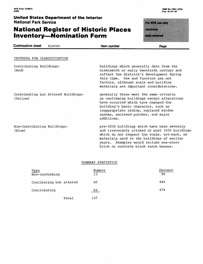
CRITERIA FOR CLASSIFICATION
Contributing Buildings: (Red)
Contributing but Altered Buildings: (Yellow)
Non-Contributing Buildings: (Blue)
buildings which generally date from the nineteenth or early twentieth century and reflect the district's development during this time. Use and function are not factors, although scale and building materials are important considerations.
generally these meet the same criteria as conforming buildings except alterations have occurred which have changed the building's basic character, such as inappropriate siding, replaced window sashes, enclosed porches, and major additions.
pre-1930 buildings which have been severely and irrevocably altered or post 1930 buildings which do not respect the scale, set-back, or materials used in the buildings of earlier years. Examples would include one-story brick or concrete block ranch houses.
TypeNon-conforming
Contibuting but altered
Contributing
Total
SUMMARY STATISTICS
Number 13
60
64
Percent 9%
44%
47%
137
NFS Form 10-900-a (3-82)
OMB No. 1024-0018 Exp. 10-31-64
United States Department of the InteriorNational Park Service
National Register of Historic Places Inventory—Nomination Form
Continuation sheet Twelve Item number Page
List of Contributing , Contributing but altered, and non-contributing Buildings in the Abbott Tract Historic District.
(See Attached Sheets)
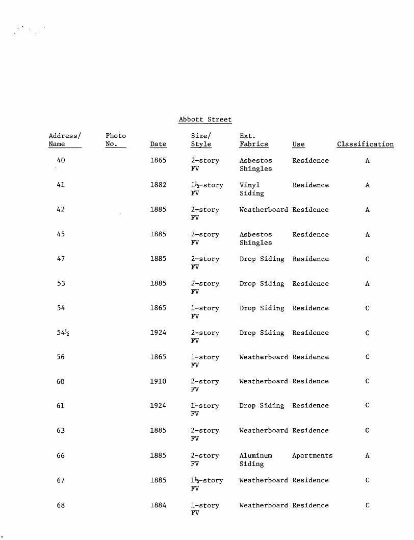
Abbott Street
Address/ Name
40
41
42
45
47
53
54
54^
56
60
61
63
66
67
68
Photo No. Date
1865
1882
1885
1885
1885
1885
1865
1924
1865
1910
1924
1885
1885
1885
1884
Size/ Style
2-story FV
1^-story FV
2-story FV
2-story FV
2-story FV
2-story FV
1-story FV
2-story FV
1-story FV
2-story FV
1-story FV
2-storyFV
2-story FV
1^-story FV
1-story FV
Ext. Fabrics Use
Asbestos Residence Shingles
Vinyl Residence Siding
Weatherboard Residence
Asbestos Residence Shingles
Drop Siding Residence
Drop Siding Residence
Drop Siding Residence
Drop Siding Residence
Weatherboard Residence
Weatherboard Residence
Drop Siding Residence
Weatherboard Residence
Aluminum Ap ar tmen t s Siding
Weatherboard Residence
Weatherboard Residence
Classification
A
A
A
A
C
A
C
C
C
C
C
C
A
C
C
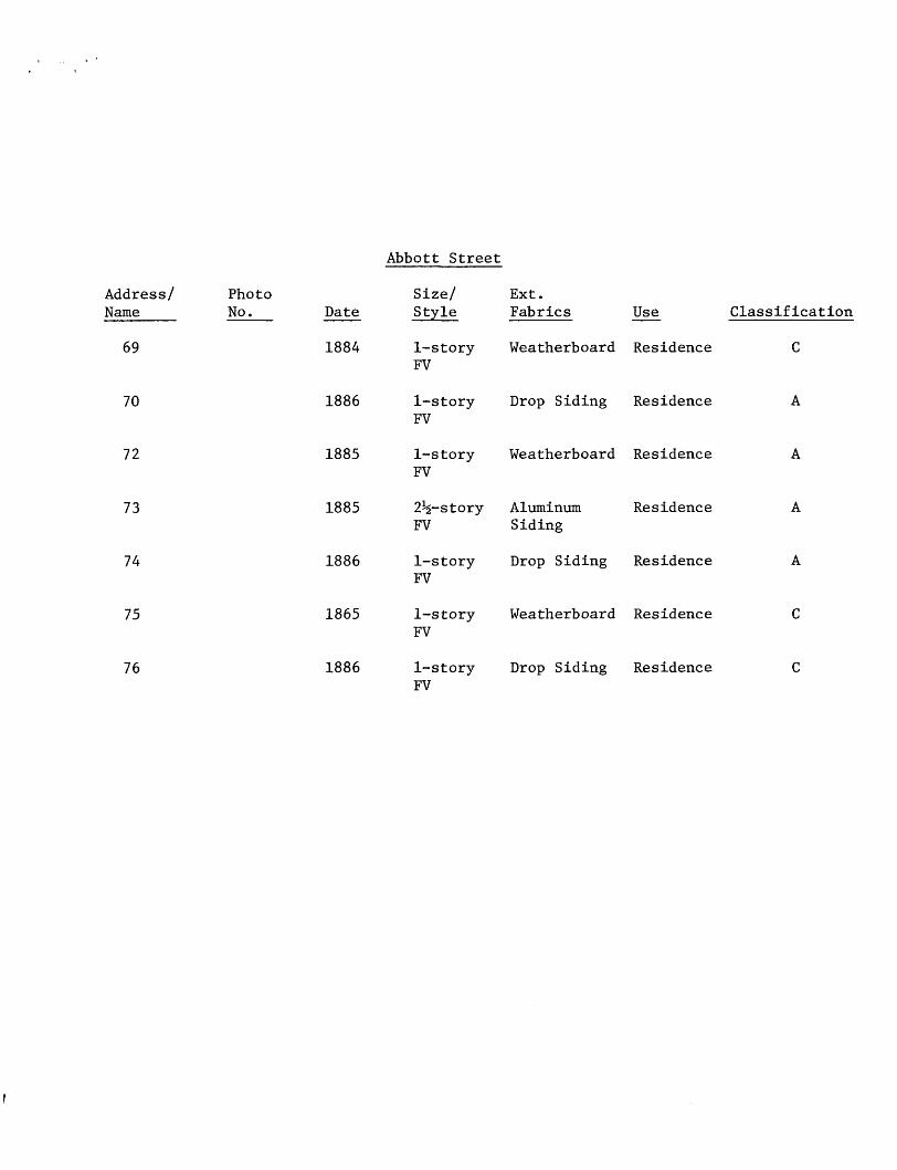
Abbott Street
Address/ Name
Photo No. Date
Size/ Style
Ext. Fabrics Use Classification
69 1884 1-story FV
Weatherboard Residence
70 1886 1-story Drop Siding Residence FV
72
73
74
1885
1885
1886
1-story FV
Weatherboard Residence
2^-story Aluminum FV Siding
Residence
1-story Drop Siding Residence FV
75 1865 1-story FV
Weatherboard Residence
76 1886 1-story Drop Siding Residence FV
Joiner Street
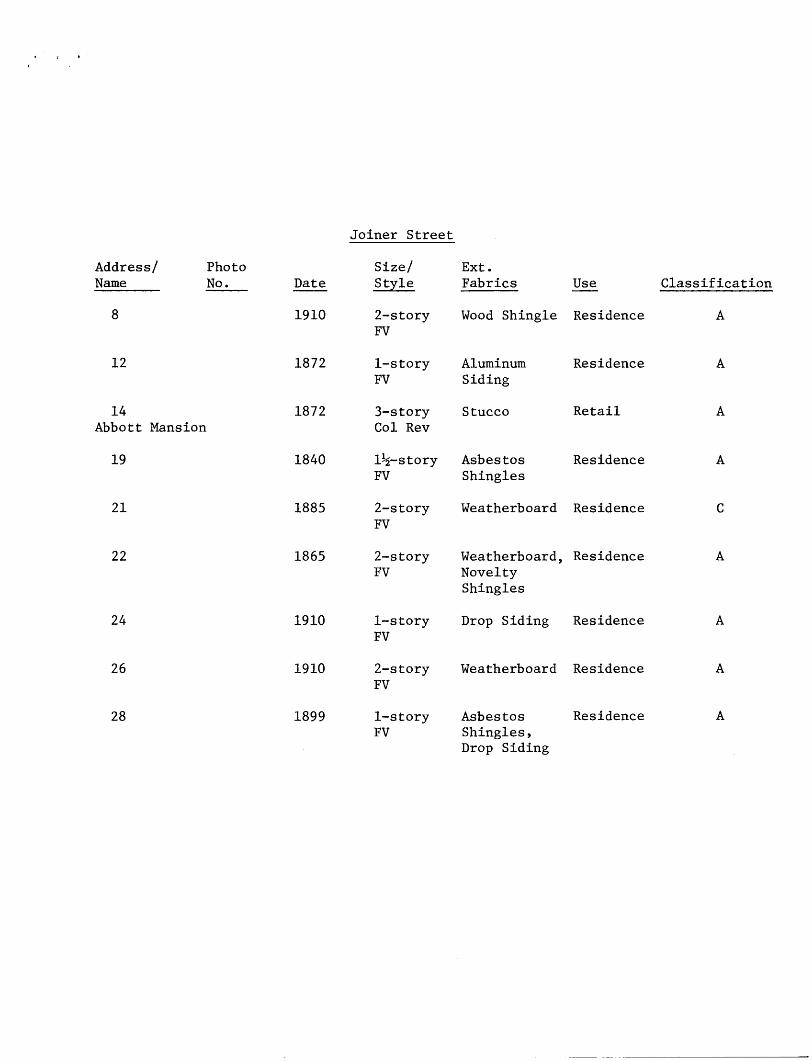
Address/ Photo Name No .
8
12
14 Abbott Mansion
19
21
22
24
26
28
Date
1910
1872
1872
1840
1885
1865
1910
1910
1899
Size/ Style
2-story FV
1-story FV
3-story Col Rev
1^-story FV
2-story FV
2-story FV
1-story FV
2-story FV
1-story FV
Ext. Fabrics Use
Wood Shingle Res
Aluminum Res: Siding
Stucco Ret,
Asbestos Res Shingles
Weatherboard Res
Weatherboard, Res: Novelty Shingles
Drop Siding Res:
Weatherboard Res:
Asbestos Res: Shingles, Drop Siding
Classification
Locust Street
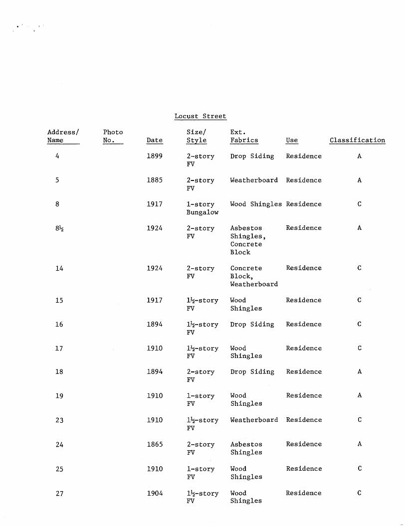
Address/ Name
4
5
8
8Jg
14
15
16
17
18
19
23
24
25
27
Photo No. Date
1899
1885
1917
1924
1924
1917
1894
1910
1894
1910
1910
1865
1910
1904
Size/ Style
2-story FV
2-story FV
1-story Bungalow
2-story FV
2-story FV
1%-story FV
1%-story FV
1^-story FV
2-story FV
1-story FV
1^-story FV
2-story FV
1-story FV
1%-story FV
Ext. Fabrics
Drop Siding
Weatherboard
Wood Shingles
Asbestos Shingles , Concrete Block
Concrete Block, Weatherboard
Wood Shingles
Drop Siding
Wood Shingles
Drop Siding
Wood Shingles
Weatherboard
Asbestos Shingles
Wood Shingles
Wood Shingles
Use
Residence
Residence
Residence
Residence
Residence
Residence
Residence
Residence
Residence
Residence
Residence
Residence
Residence
Residence
Classification
A
A
C
A
C
C
C
C
A
A
C
A
C
C
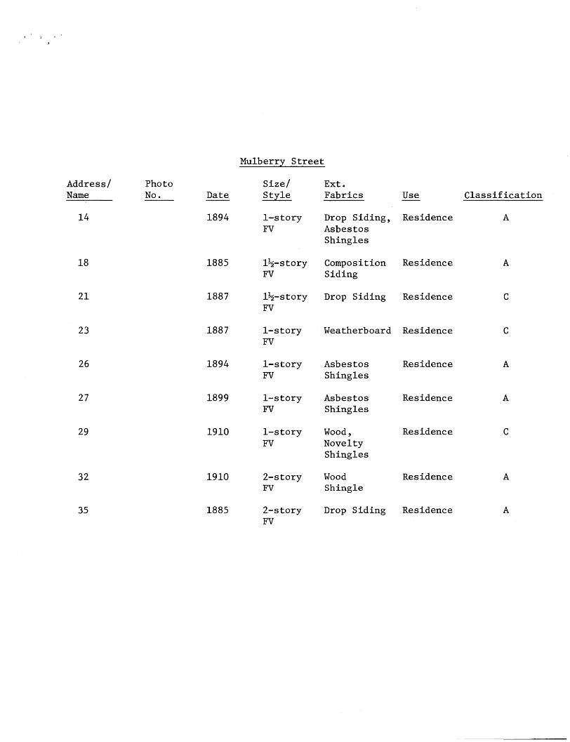
Mulberry Street
Address/ Name
14
18
21
23
26
27
29
Photo No . Date
1894
1885
1887
1887
1894
1899
1910
Size/ Style
1-story FV
1%-story FV
1^-story FV
1-story FV
1-story FV
1-story FV
1-story FV
Ext. Fabrics Use
Drop Siding, Res Asbestos Shingles
Composition Res Siding
Drop Siding Res
Weatherboard Res
Asbestos Res Shingles
Asbestos Res Shingles
Wood, Res: Novelty Shingles
32
35
Classification
1910
1885
2-story Wood FV Shingle
Residence
2-story Drop Siding Residence FV
Osceola Street
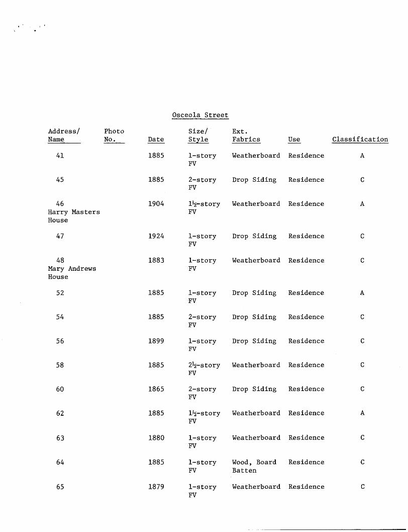
Address/ Photo Name No .
41
45
46 Harry Masters House
47
48 Mary Andrews House
52
54
56
58
60
62
63
64
65
Date
1885
1885
1904
1924
1883
1885
1885
1899
1885
1865
1885
1880
1885
1879
Size/ Style
1-story FV
2-story FV
1^-story FV
1-story FV
1-story FV
1-story FV
2-story FV
1-story FV
2^-story FV
2-story FV
1%-story FV
1-story FV
1-story FV
1-story FV
Ext. Fabrics
Weatherboard
Drop Siding
Weatherboard
Drop Siding
Weatherboard
Drop Siding
Drop Siding
Drop Siding
Weatherboard
Drop Siding
Weatherboard
Weatherboard
Wood, Board Batten
Weatherboard
Use
Residence
Residence
Residence
Residence
Residence
Residence
Residence
Residence
Residence
Residence
Residence
Residence
Residence
Residence
Classification
A
C
A
C
C
A
C
C
C
C
A
C
C
C
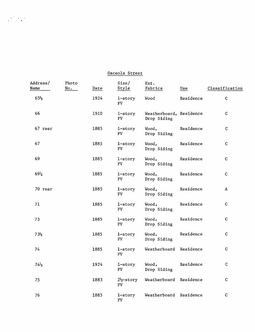
Osceola Street
Address/ PhotoName No .
65^
66
67 rear
67
69
69%
70 rear
71
73
73*2
74
74!$
75
76
Date
1924
1910
1885
1885
1885
1885
1885
1885
1885
1885
1885
1924
1883
1885
Size/Style
1-story FV
1-story FV
1-story FV
1-story FV
1-story FV
1-story FV
1-story FV
1-story FV
1-story FV
1-story FV
1-story FV
1-story FV
2%-story FV
1-story FV
Ext.Fabrics
Wood
Weatherboard , Drop Siding
Wood, Drop Siding
Wood, Drop Siding
Wood, Drop Siding
Wood, Drop Siding
Wood, Drop Siding
Wood, Drop Siding
Wood, Drop Siding
Wood, Drop Siding
Weatherboard
Wood, Drop Siding
Weatherboard
Weatherboard
Use
Residence
Residence
Residence
Residence
Residence
Residence
Residence
Residence
Residence
Residence
Residence
Residence
Residence
Residence
Classification
C
C
C
C
C
C
A
C
C
C
C
C
C
C
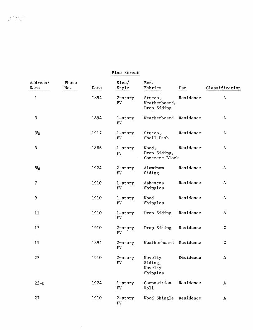
Pine Street
Address/ Name
1
3
%
5
5^
7
9
11
13
15
23
25-B
27
Photo No . Date
1894
1894
1917
1886
1924
1910
1910
1910
1910
1894
1910
1924
1910
Size/ Style
2-story FV
1-story FV
1-story FV
1-story FV
2-story FV
1-story FV
1-story FV
1-story FV
2-story FV
2-story FV
2-story FV
1-story FV
2-story FV
Ext. Fabrics
Stucco, Weatherboard, Drop Siding
Weatherboard
Stucco, Shell Dash
Use
Residence
Residence
Residence
Wood, Residence Drop Siding, Concrete Block
Aluminum Siding
Asbestos Shingles
Wood Shingles
Drop Siding
Drop Siding
Weatherboard
Novelty Siding, Novelty Shingles
Composition Roll
Wood Shingle
Residence
Residence
Residence
Residence
Residence
Residence
Residence
Residence
Residence
Classification
A
A
A
A
A
A
A
A
C
C
A
A
A
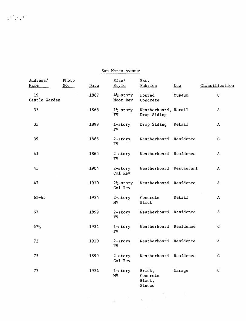
San Marco Avenue
Photo No.
19 Castle Warden
33
35
Date
1887
1865
1899
Size/ Style
Ext. Fabrics
4^-stdry Poured Moor Rev Concrete
Use
Museum
1^-story Weatherboard, Retail FV Drop Siding
1-story Drop Siding Retail FV
Classification
39 1865 2-story Weatherboard Residence FV
41 1865 2-story Weatherboard Residence FV
45
47
1904 2-story Weatherboard Restaurant Col Rev
1910 2^-story Weatherboard Residence Col Rev
63-65 1924 2-story Concrete MV Block
Retail
67
67%
1899 2-story Weatherboard Residence FV
1924 1-story Weatherboard Residence FV
A
73 1910 2-story Weatherboard Residence FV
A
75 1899 2-story Weatherboard Residence Col Rev
77 1924 1-story Brick,MV Concrete
Block, Stucco
Garage
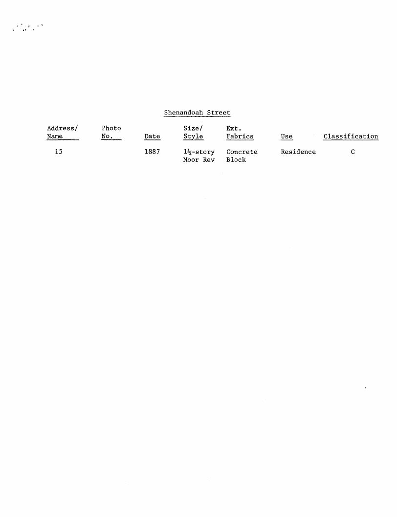
Shenandoah Street
Address/ Photo Size/ Ext.Name No. Date Style Fabrics Use Classification
15 1887 1^-story Concrete Residence CMoor Rev Block
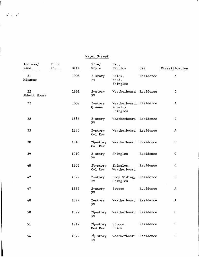
Water Street
Address/ Photo Name No .
21 Miramar
22 Abbott House
23
28
33
38
39
40
42
47
48
50
51
54
Date
1905
1861
1839
1885
1885
1910
1910
1906
1872
1885
1872
1872
1917
1872
Size/ Style
2-story FV
2-story FV
2-story Q Anne
2-story FV
2-story Col Rev
2%-story Col Rev
2-story FV
2%-story Col Rev
2-story FV
2-story FV
2-story FV
2%- story FV
2^-story Med Rev
2^-story FV
Ext. Fabrics
Brick, Wood, Shingles
Weatherboard
Weatherboard , Novelty Shingles
Weatherboard
Weatherboard
Weatherboard
Shingles
Shingles, Weatherboard
Drop Siding, Shingles
Stucco
Weatherboard
Weatherboard
Stucco, Brick
Weatherboard
Use
Residence
Residence
Residence
Residence
Residence
Residence
Residence
Residence
Residence
Residence
Residence
Residence
Residence
Residence
Classification
A
C
A
C
A
C
C
C
C
A
A
C
C
C
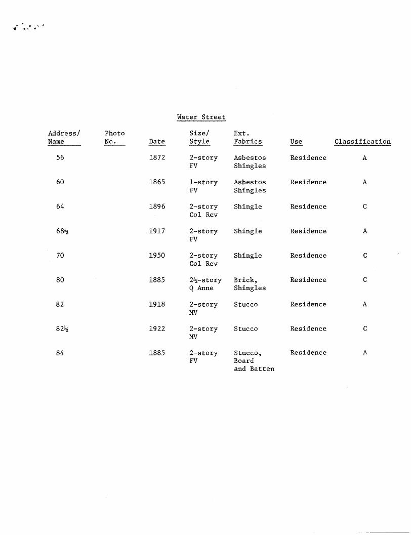
Water Street
Address/ Name
56
60
64
68%
70
80
82
82%
84
Photo No. Date
1872
1865
1896
1917
1950
1885
1918
1922
1885
Size/ Style
2-story FV
1-story FV
2-story Col Rev
2-story FV
2-story Col Rev
2%-story Q Anne
2-story MV
2-story MV
2-story FV
Ext. Fabrics
Asbestos Shingles
Asbestos Shingles
Shingle
Shingle
Shingle
Brick, Shingles
Stucco
Stucco
Stucco, Board and Batten
Use
Residence
Residence
Residence
Residence
Residence
Residence
Residence
Residence
Residence
Classification
A
A
C
A
C
C
A
C
A
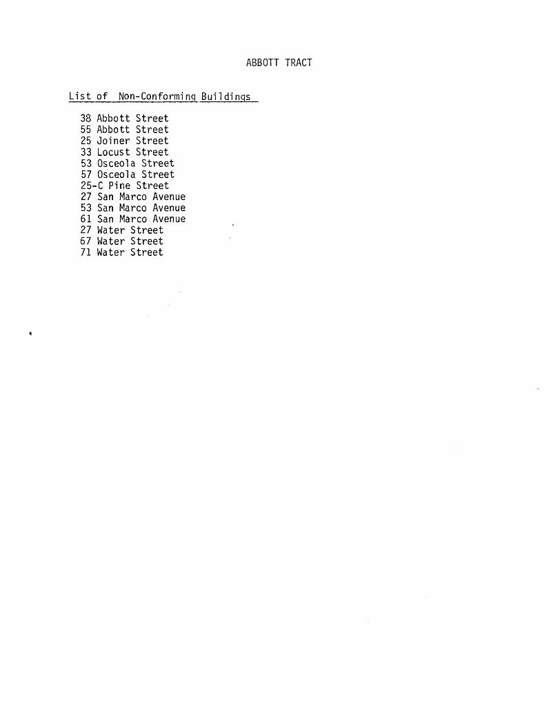
ABBOTT TRACT
List of Non-Conforming Buildings
38 Abbott Street 55 Abbott Street 25 Joiner Street 33 Locust Street 53 Osceola Street 57 Osceola Street 25-C Pine Street 27 San Marco Avenue 53 San Marco Avenue 61 San Marco Avenue 27 Water Street 67 Water Street 71 Water Street