Cool Science from Cold Places: Classroom Activities to Explore the Cryosphere and Polar Regions
CNES PRIORITIES IN POLAR AND CRYOSPHERE RESEARCH
Polar Space Task Group – 3rd Session
Juliette Lambin, Steven Hosford
Wednesday, May 22th, 2013
Paris, France
1
OU
TLIN
E
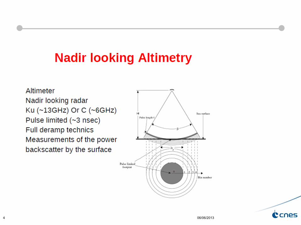
CNES MISSIONS FOR POLAR/CRYOSPHERE OBSERVATIONSRADAR: ALTIMETRY, SAROPTICAL IMAGERY
06/06/20132
Présentation programme SARAL – J. Lambin, février 20133
10 11 12 13 14 15 16 17 18 19 20 21 22
Wide‐Swath
altimetry
Saral/AltiKa Fr./India
09Launc h date
Altimetry12/01
3/02
Jason-1 France/USA Jason-3 Europe/USA
Proposed (A/B)
Sentinel‐3B Europe
SWOT USA/France
Jason‐CS
A and B Europe/USA
Sentinel-3A Europe
fp July 2012
Geodetic orbit
ENVISAT Europe
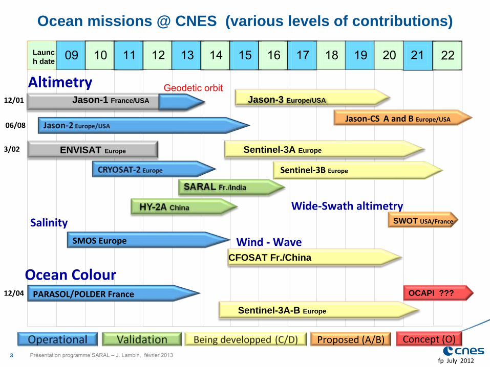
Ocean missions @ CNES (various levels of contributions)
06/08
SalinitySMOS Europe
CFOSAT Fr./ChinaWind ‐
Wave
Ocean ColourPARASOL/POLDER France12/04 OCAPI ???
Concept (O)
Sentinel-3A-B Europe
06/06/20134
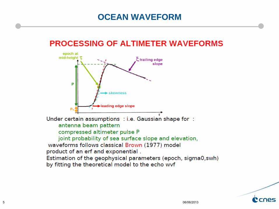
OCEAN WAVEFORM
06/06/20135
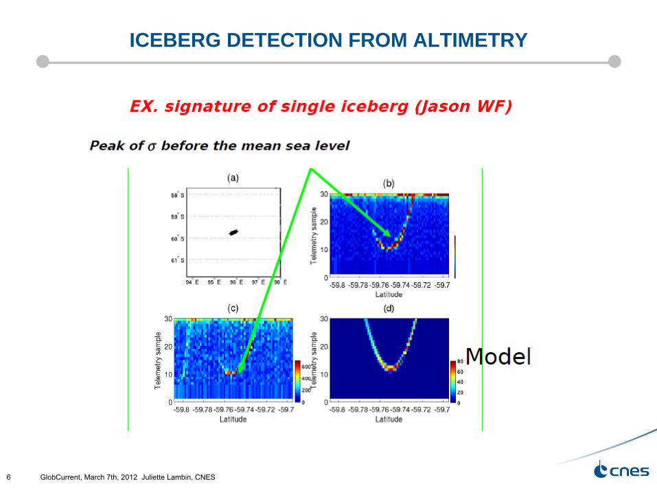
ICEBERG DETECTION FROM ALTIMETRY
GlobCurrent, March 7th, 2012 Juliette Lambin, CNES6
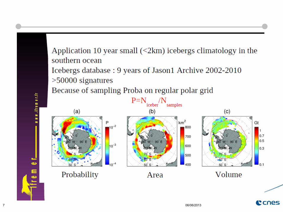
06/06/20137
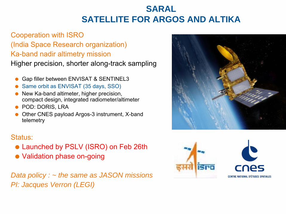
SARAL SATELLITE FOR ARGOS AND ALTIKA
Cooperation with ISRO (India Space Research organization)Ka-band nadir altimetry missionHigher precision, shorter along-track sampling
Gap filler between ENVISAT & SENTINEL3Same orbit as ENVISAT (35 days, SSO)New Ka-band altimeter, higher precision, compact design, integrated radiometer/altimeterPOD: DORIS, LRAOther CNES payload Argos-3 instrument, X-band telemetry
Status: Launched by PSLV (ISRO) on Feb 26th Validation phase on-going
Data policy : ~ the same as JASON missionsPI: Jacques Verron (LEGI)
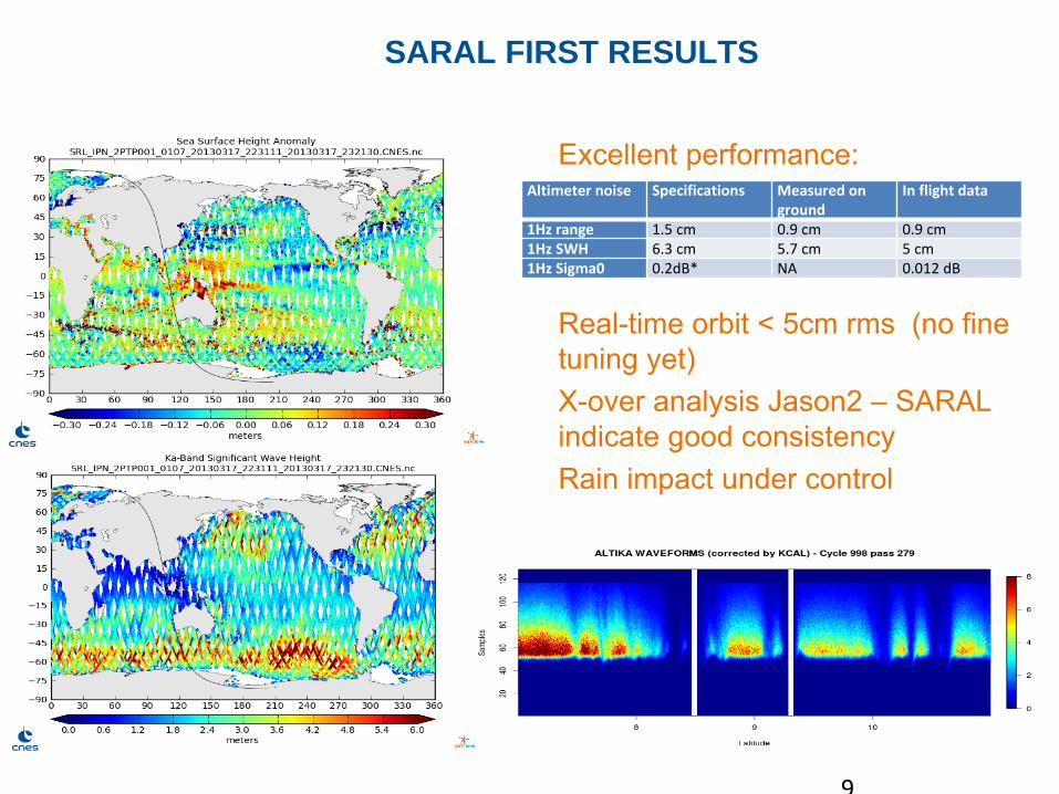
SARAL FIRST RESULTS
Altimeter noise Specifications Measured on
ground In flight data
1Hz range 1.5 cm 0.9 cm 0.9 cm1Hz SWH 6.3 cm 5.7 cm 5 cm1Hz Sigma0 0.2dB* NA 0.012 dB
Excellent performance:
Real-time orbit < 5cm rms (no fine tuning yet)X-over analysis Jason2 –
SARAL indicate good consistencyRain impact under control
9
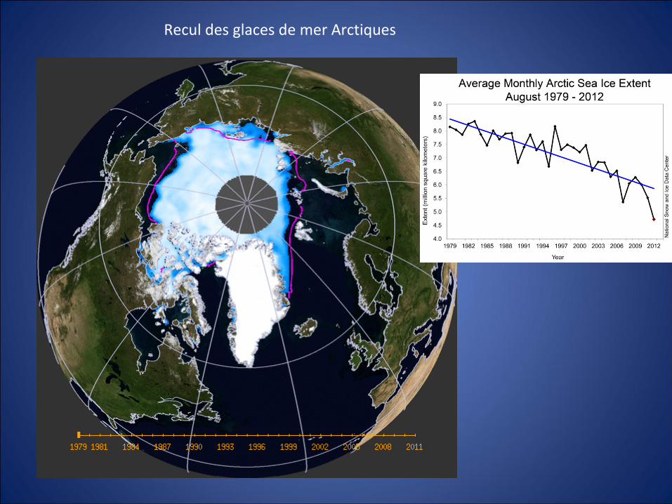
Recul des glaces de mer Arctiques

Sea Ice Thickness accessible through altimetry
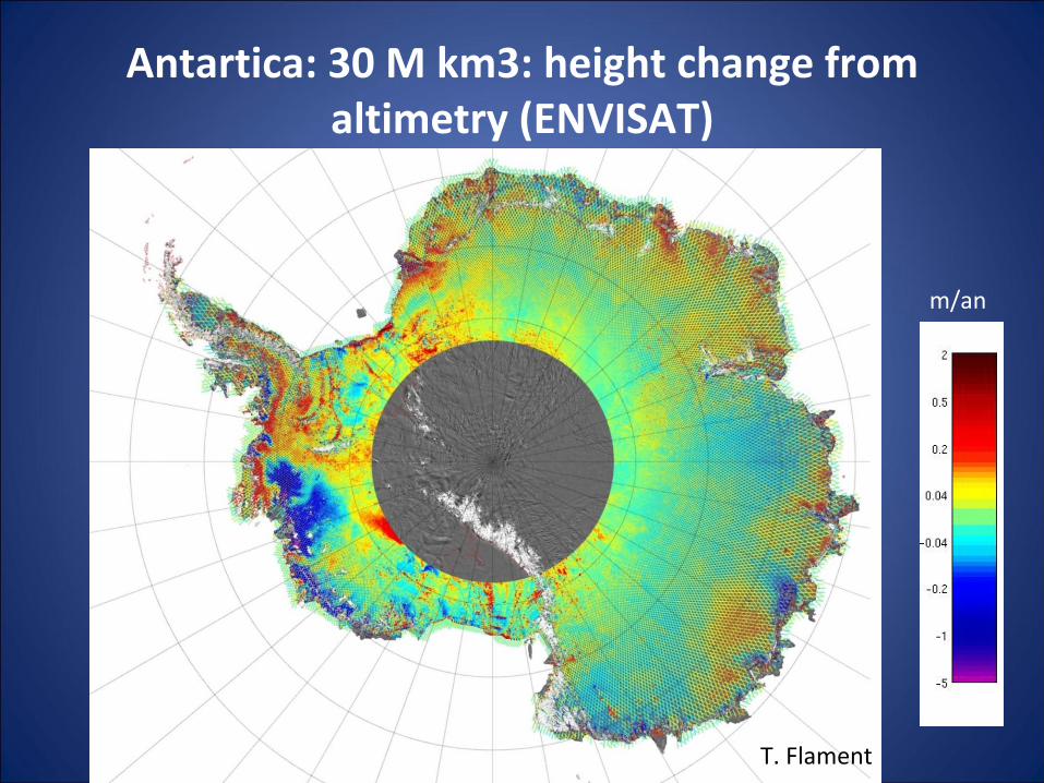
Antartica: 30 M km3: height change from altimetry (ENVISAT)
m/an
T. Flament
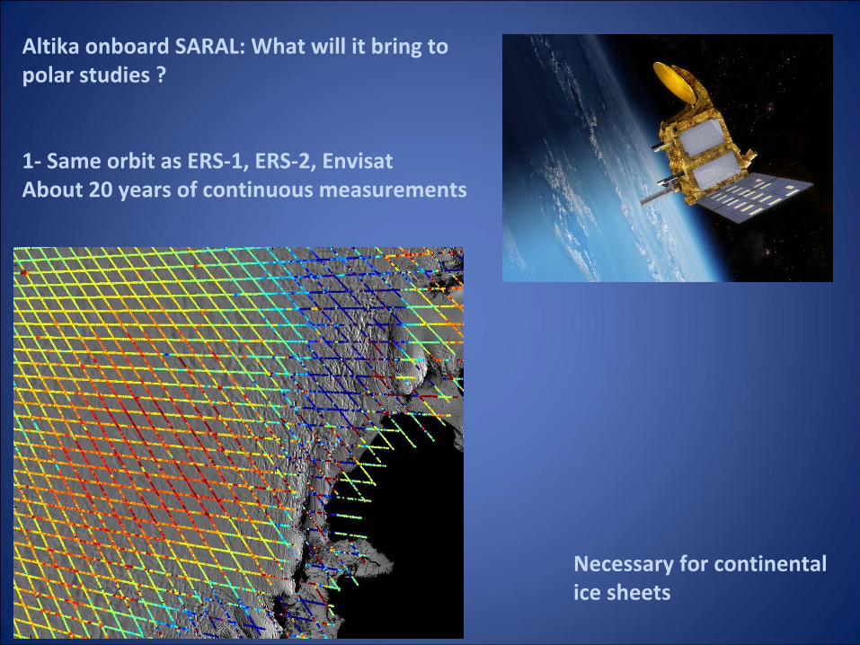
Altika onboard SARAL: What will it bring to
polar studies ?
1‐
Same orbit as ERS‐1, ERS‐2, EnvisatAbout 20 years of continuous measurements
Necessary for continental
ice sheets
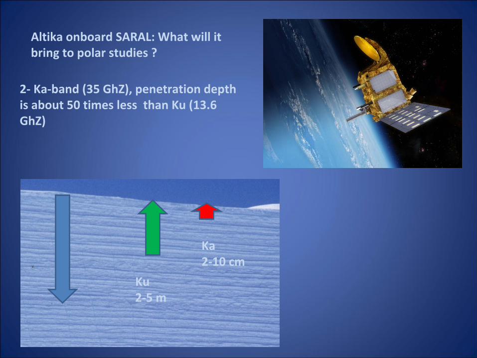
Altika onboard SARAL: What will it
bring to polar studies ?
Ku2‐5 m
Ka2‐10 cm
2‐
Ka‐band (35 GhZ), penetration depth
is about 50 times less than Ku (13.6
GhZ)
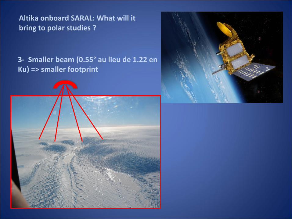
3‐
Smaller beam (0.55°
au lieu de 1.22 en
Ku) => smaller footprint
Altika onboard SARAL: What will it
bring to polar studies ?
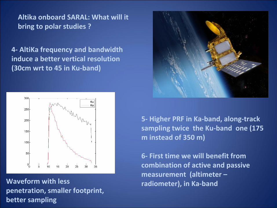
4‐
AltiKa frequency and bandwidth
induce a better vertical resolution
(30cm wrt to 45 in Ku‐band)
Waveform with less
penetration, smaller footprint,
better sampling
5‐
Higher PRF in Ka‐band, along‐track
sampling twice the Ku‐band one (175
m instead of 350 m)
6‐
First time we will benefit from
combination of active and passive
measurement (altimeter –
radiometer), in Ka‐band
Altika onboard SARAL: What will it
bring to polar studies ?
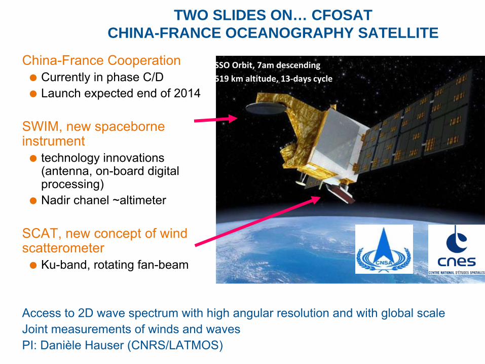
TWO SLIDES ON… CFOSAT CHINA-FRANCE OCEANOGRAPHY SATELLITE
China-France CooperationCurrently in phase C/DLaunch expected end of 2014
SWIM, new spaceborne instrument
technology innovations (antenna, on-board digital processing)Nadir chanel ~altimeter
SCAT, new concept of wind scatterometer
Ku-band, rotating fan-beam
Access to 2D wave spectrum with high angular resolution and with
global scaleJoint measurements of winds and wavesPI: Danièle Hauser (CNRS/LATMOS)
►SSO Orbit, 7am descending
►519 km altitude, 13‐days cycle
18
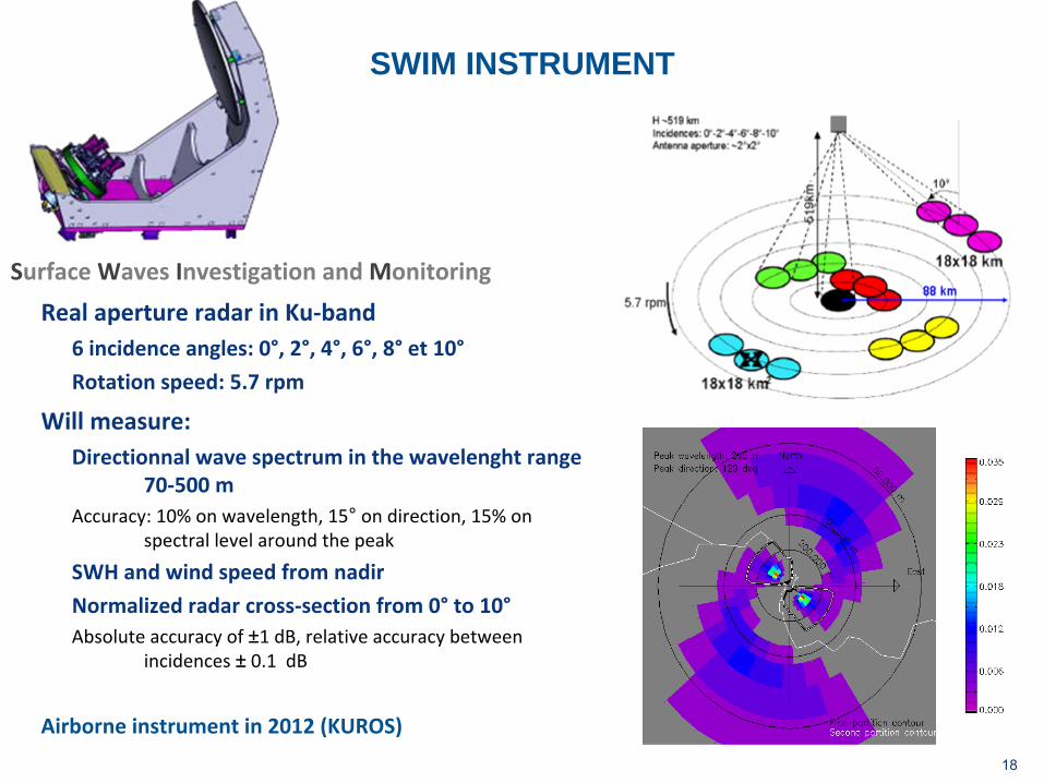
SWIM INSTRUMENT
Surface Waves Investigation and Monitoring
Real aperture radar in Ku‐band6 incidence angles: 0°, 2°, 4°, 6°, 8°
et 10°
Rotation speed: 5.7 rpm
Will measure:Directionnal wave spectrum in the wavelenght range
70‐500 m
Accuracy: 10% on wavelength, 15°
on direction, 15% on
spectral level around the peak
SWH and wind speed from nadir
Normalized radar cross‐section from 0°
to 10°Absolute accuracy of ±1 dB, relative accuracy between
incidences ±
0.1 dB
Airborne instrument in 2012 (KUROS)
CFOSAT ON ICE
•
Secondary objectives–
polar ice sheet and land surfacemonitoring: roughness, vegetation and soil moistness in semi-arid regions, polar ice sheet characterics=>Multi-incidence normalized radar cross-section for estimatingSurface parameters (in particular roughness)
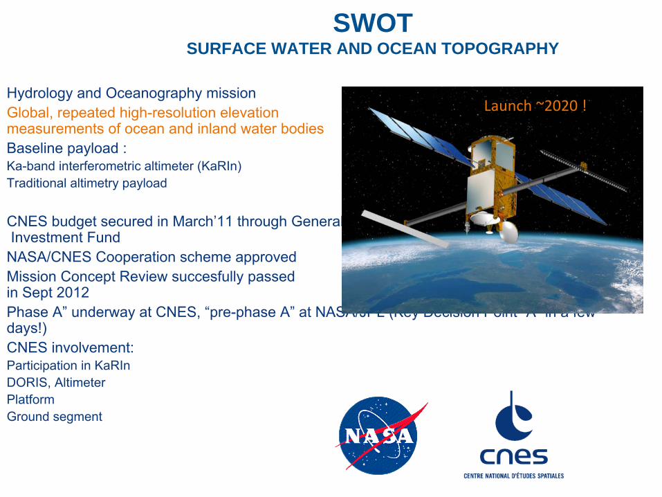
SWOT SURFACE WATER AND OCEAN TOPOGRAPHY
Hydrology and Oceanography mission Global, repeated high-resolution elevation measurements of ocean and inland water bodiesBaseline payload : Ka-band interferometric altimeter (KaRIn)Traditional altimetry payload
CNES budget secured in March’11 through General
Investment Fund
NASA/CNES Cooperation scheme approvedMission Concept Review succesfully passed in Sept 2012Phase A”
underway at CNES, “pre-phase A”
at NASA/JPL (Key Decision Point “A”
in a few days!)CNES involvement:Participation in KaRInDORIS, AltimeterPlatformGround segment
Launch ~2020 !
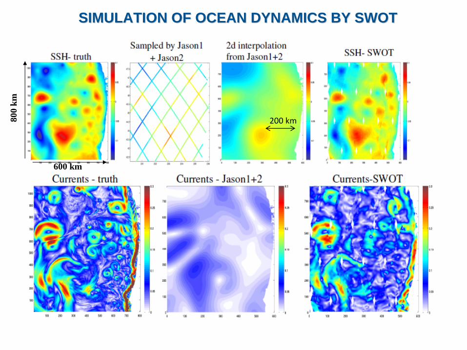
SIMULATION OF OCEAN DYNAMICS BY SWOTSIMULATION OF OCEAN DYNAMICS BY SWOT80
0 km
600 km
200 km
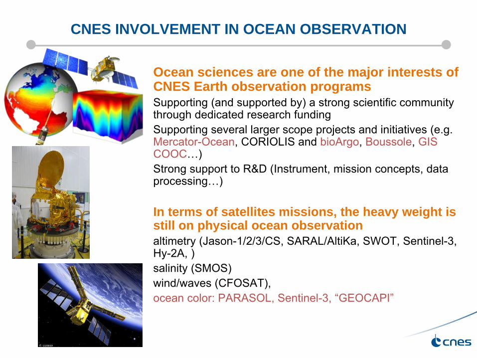
CNES INVOLVEMENT IN OCEAN OBSERVATION
Ocean sciences are one of the major interests of CNES Earth observation programsSupporting (and supported by) a strong scientific community through dedicated research funding Supporting several larger scope projects and initiatives (e.g. Mercator-Ocean, CORIOLIS and bioArgo, Boussole, GIS COOC…)Strong support to R&D (Instrument, mission concepts, data processing…)
In terms of satellites missions, the heavy weight is still on physical ocean observationaltimetry (Jason-1/2/3/CS, SARAL/AltiKa, SWOT, Sentinel-3, Hy-2A, )salinity (SMOS) wind/waves (CFOSAT),ocean color: PARASOL, Sentinel-3, “GEOCAPI”