


Languages
Pages
Legal

Welcome to AP Human Geography

On your index cards please write the following:
NameYear in schoolEmail One interesting fact about yourselfFavorite band or artist/movie/TV showAny after-school activities you participate in
What do you want to learn in this class?
A question for me

Things to remember… Get to class on time Avoid talking when you’re supposed to be
listening Cell phones should not be seen unless otherwise
instructed (free time) Get work in on time Do the extra credit on line test Look at the calendar Ask for help…communicate Be proactive “my printer didn’t work” is old! Give it your best effort! Have fun

Chapter Chapter1
Thinking Geographically
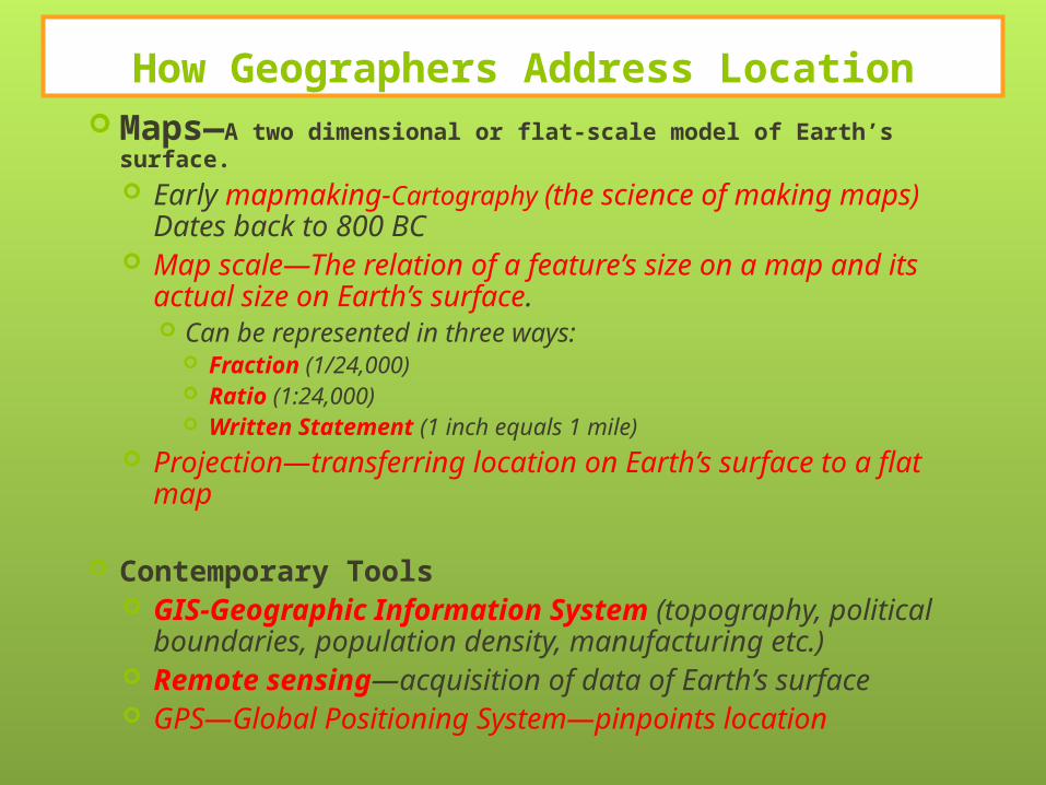
How Geographers Address Location Maps—A two dimensional or flat-scale model of Earth’s
surface. Early mapmaking-Cartography (the science of making
maps) Dates back to 800 BC Map scale—The relation of a feature’s size on a map and
its actual size on Earth’s surface. Can be represented in three ways:
Fraction (1/24,000) Ratio (1:24,000) Written Statement (1 inch equals 1 mile)
Projection—transferring location on Earth’s surface to a flat map
Contemporary Tools GIS-Geographic Information System (topography,
political boundaries, population density, manufacturing etc.)
Remote sensing—acquisition of data of Earth’s surface GPS—Global Positioning System—pinpoints location

Contemporary Tools
GIS-Geographic Information System (topography, political boundaries, population density, manufacturing etc.)
Remote sensing—acquisition of data of Earth’s surface
GPS—Global Positioning System—pinpoints location

Warm up: White Boards Please!
1. What is the farthest distance you are willing/able to walk?
2. If there were no cars or other transportation, what could you get to on foot from your house at this distance?
3. What would your life be like to live only within a circular area with this distance as the radius?

landuse
Urban vs Rural. How do we determine what land is used for?

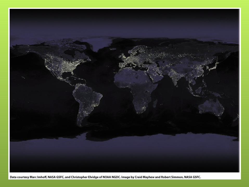
World Political Boundaries (2004)
Fig. 1-1: National political boundaries are among the most significant elements of the cultural landscape

Large Scale Map VS. Small Scale Map
A large scale map only shows a small area, but it shows it in great detail. A map depicting a large area, such as an entire country, is considered a small
scale map. In order to show the entire country, the map must be scaled down until it is much smaller. A small scale map shows more territory, but it is less detailed.
Distortion is a problem that arises in: Shape Distance Relative Size Direction
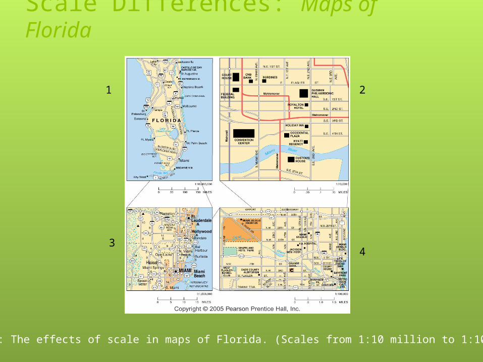
Scale Differences: Maps of Florida
Fig. 1-3: The effects of scale in maps of Florida. (Scales from 1:10 million to 1:10,000)
1 2
34

Township and Range System in the U.S.
Fig. 1-4: Principal meridians and east-west baselines of the township system. Townships in northwest Mississippi and topographic map of the area.

Layers of a GIS
Fig. 1-5: A geographic information system (GIS) stores information about a location in several layers. Each layer represents a different category of information.

Uniqueness of Places and RegionsPlace: Unique location of a feature
Place names—AKA toponym Site—Physical characteristics (climate,
topography, soil, vegetation, elevation) Situation-The location relative to other
locations Mathematical location—longitude/latitudeAbsolute Location: the position or
place a certain item on the surface of the Earth as expressed in degrees, minutes and seconds of latitude and longitude
Relative Location: the location of a place relative to other human and physical features on the landscape

Site: Broadneck Peninsula
How would you describe the site of the Broadneck Peninsula?

Situation: Broadneck Penninsula
.
How would you describe the situation of the Broadneck Peninsula? (white boards please)

Regions: Areas of unique characteristicsCultural landscape—combination of cultural
features such as language, religion, economic, climate
Types of regions—two scales—several neighboring countries that share important features (Latin America)
Regional integration of cultureCultural ecology: study of human
adaptations to social and physical environments.Environmental DeterminismPossiblism
Environmental Determinism
Physical environment causes human activities: Caribbean climate is said to cause laid back, lazy lifestyles

Possiblism Physical environment may limit some human
activities, but people have the ability to adjust to their environment People learn that different crops thrive in
different environments Rice requires a lot of water, wheat is more
successful in colder climates

World Geographic Grid
Fig. 1-8: The world geographic grid consists of meridians of longitude and parallels of latitude. The prime meridian (0º) passes through Greenwich, England.

World Time Zones
Fig. 1-9: The world’s 24 standard time zones are often depicted using the Mercator projection.

On your white boards:List as many states that you
think are included in the south.

Types of Regions1. Formal or Uniform: largest area
where a valid generalization hold true. Generally has defined borders/boundaries
• Common Languages• Production of a Certain Crop• Climate
2. Functional or Nodal: defined by interactions and connections
• Newspaper circulation (Washington Post)• Reception area of a TV Station

Types of Regions3.Perceptual or Vernacular:
based on our feelings and images1. Yankee Nation2. The “south”3. A gang’s turf
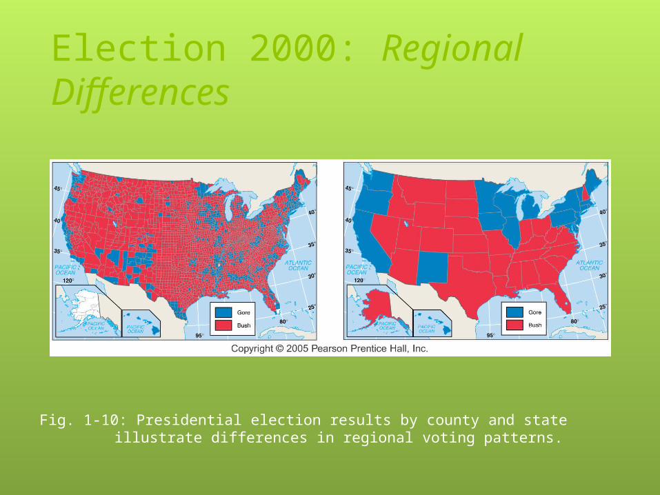
Election 2000: Regional Differences
Fig. 1-10: Presidential election results by county and state illustrate differences in regional voting patterns.
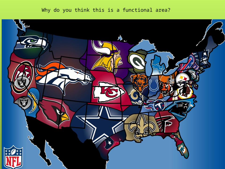
Why do you think this is a functional area?
What do you associate with the South?Where is “The South” and what determines where that is?

Vernacular Regions
Fig. 1-12: A number of factors are often used to define the South as a vernacular region, each of which identifies somewhat different boundaries.
Similarity of Different PlacesScale: From local to global
Globalization of economy-the world is shrinking in size--communication
Globalization of culture—western cultural influences…good or bad?
Space: Distribution of featuresDistribution—measures how “things”
are distributed in a given area—IE houses in Annapolis
Gender and ethnic diversity in space—where do people live? Travel? Work?

–Spatial interaction
–Faster Travel, communication
–Interaction—some barriers such as language, culture or physical—oceans
–Distance Decay—the farther away one group is from another, the less likely the two will interact
–Diffusion—How a characteristic spreads across space from one place to another over time
–The place of origin--hearth
Connections Between Places
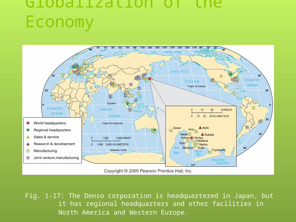
Globalization of the Economy
Fig. 1-17: The Denso corporation is headquartered in Japan, but it has regional headquarters and other facilities in North America and Western Europe.

Density, Concentration, and Pattern
Fig. 1-18: The density, concentration, and pattern (of houses in this example) may each vary in an area or landscape.
Arithmetic Density: the total number of people per square milePhysiological density: the number of persons per unit of area suitable for agricultureAgricultural density: the number of farmers per unit area of farmland
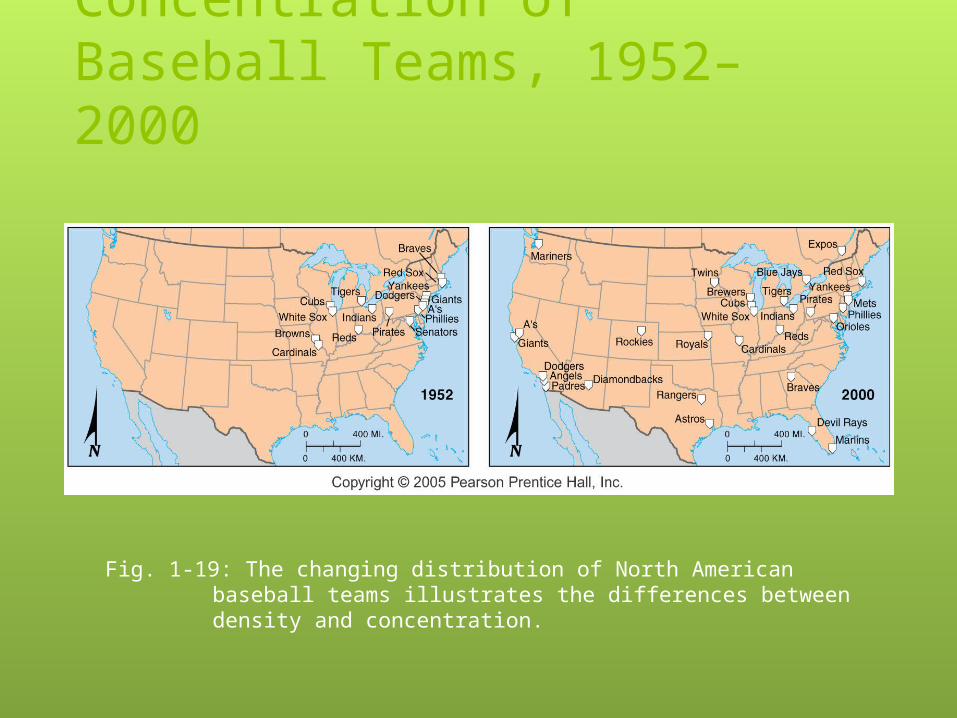
Density and Concentration of Baseball Teams, 1952–2000
Fig. 1-19: The changing distribution of North American baseball teams illustrates the differences between density and concentration.

Airline Route Networks
Fig. 1-21: Delta Airlines, like many others, has configured its route network in a “hub and spoke” system.

Expansion Diffusion—the spread of a feature from one place to another.
Can be accomplished in one of three ways:
Hierarchical diffusion—The spread of ideas from authority (Soccer: began in England when it was a
world super power)
Contagious diffusion—The rapid, wide-spread diffusion of a characteristic throughout the population
AIDS, silly bands
Stimulus diffusion—The spread of an underlying principle. More modern in nature—use of computers
The use of a mouse on computers
Diffusion of Culture and Economy
Global economy is centered on three core/hearth regions
North America, Western Europe and Japan
Uneven development—The increasing gap in economic conditions between regions in the core and periphery.
TV/Computers/Cell phones/IPODS
Diffusion
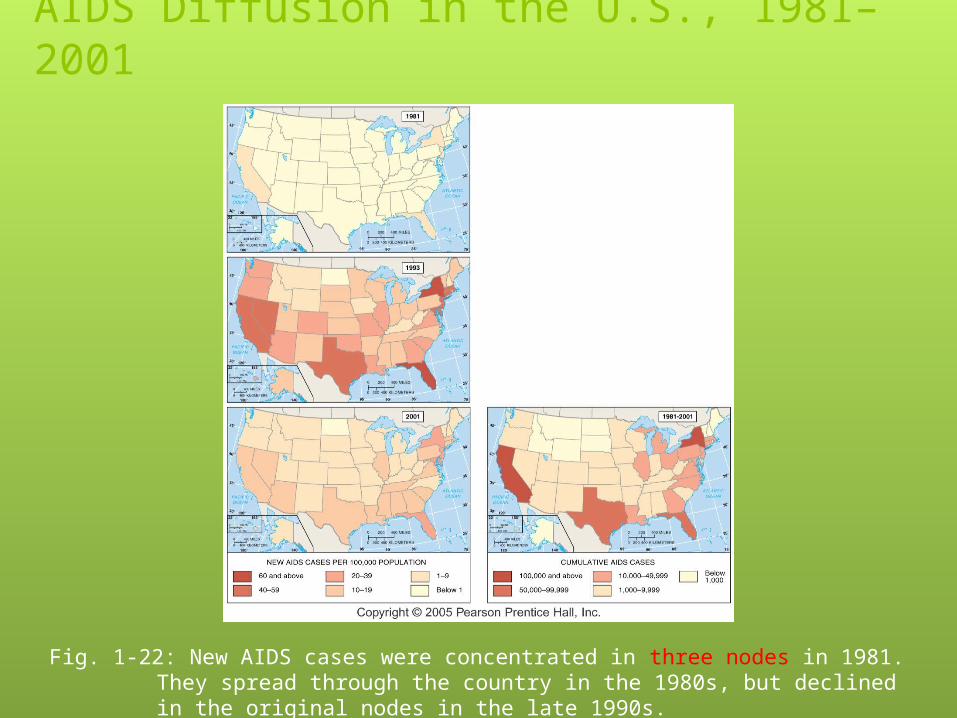
AIDS Diffusion in the U.S., 1981–2001
Fig. 1-22: New AIDS cases were concentrated in three nodes in 1981. They spread through the country in the 1980s, but declined in the original nodes in the late 1990s.

You’re off to a great start!
Top Related