


Languages
Pages
Legal


Web MercatorThe Standard for Sharing Data on the Web
Many organizations use geographic information system (GIS) data stored in a local projected coordinate system. When preparing to share maps or layers on the Web, it is recommended to reproject your source data to the Web Mercator coordinate system. Doing so will ensure that your map data is located correctly and aligns properly with other services such as popular content providers Microsoft® Bing™ Maps, Google Maps™, and ESRI® ArcGIS SM Online, which have standardized their services on the Web Mercator coordinate system.
Projecting Your Data to Web MercatorIn ArcGIS®, you have two options if you want to reproject your data to the Web Mercator coordinate system. The first, using the Project tool, creates a copy of your data that replaces the original coordinates in your source data with new coordinates from the Web Mercator coordinate system. The second, setting the ArcMap™ data frame coordinate system, instructs ArcGIS to calculate the new coordinates only when needed—leaving your source data unchanged. Since the first option requires a complete copy of your data to be made, you may want to use it for data that does not change very often—such as basemaps. You can then use the second option for data that changes often—when it would be too time-consuming to keep creating copies of your data. Both options are presented for your reference.
For ArcGIS Server Web mapping applications, developers can use the geometry service to reproject features before making area and length calculations. Reprojecting features is not a problem since positional accuracy is preserved when projecting between Web Mercator and other coordinate systems.
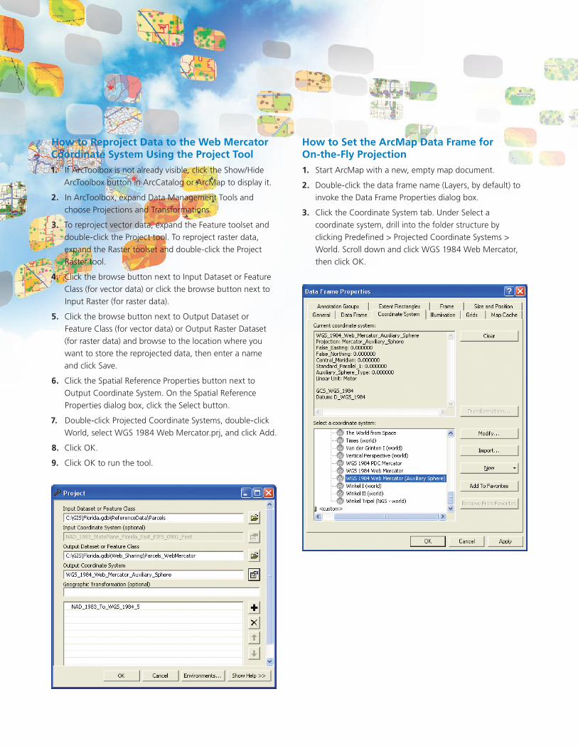
How to Set the ArcMap Data Frame for On-the-Fly Projection
Start ArcMap with a new, empty map document.1.
Double-click the data frame name (Layers, by default) to 2. invoke the Data Frame Properties dialog box.
Click the Coordinate System tab. Under Select a 3. coordinate system, drill into the folder structure by clicking Predefined > Projected Coordinate Systems > World. Scroll down and click WGS 1984 Web Mercator, then click OK.
How to Reproject Data to the Web Mercator Coordinate System Using the Project Tool
If ArcToolbox is not already visible, click the Show/Hide 1. ArcToolbox button in ArcCatalog or ArcMap to display it.
In ArcToolbox, expand Data Management Tools and 2. choose Projections and Transformations.
To reproject vector data, expand the Feature toolset and 3. double-click the Project tool. To reproject raster data, expand the Raster toolset and double-click the Project Raster tool.
Click the browse button next to Input Dataset or Feature 4. Class (for vector data) or click the browse button next to Input Raster (for raster data).
Click the browse button next to Output Dataset or 5. Feature Class (for vector data) or Output Raster Dataset (for raster data) and browse to the location where you want to store the reprojected data, then enter a name and click Save.
Click the Spatial Reference Properties button next to 6. Output Coordinate System. On the Spatial Reference Properties dialog box, click the Select button.
Double-click Projected Coordinate Systems, double-click 7. World, select WGS 1984 Web Mercator.prj, and click Add.
Click OK.8.
Click OK to run the tool.9.
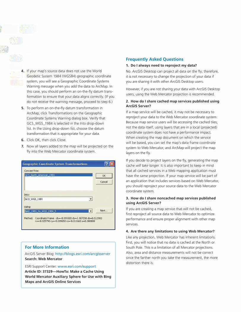
If your map’s source data does not use the World 4. Geodetic System 1984 (WGS84) geographic coordinate system, you will see a Geographic Coordinate Systems Warning message when you add the data to ArcMap. In this case, you should perform an on-the-fly datum trans-formation to ensure that your data aligns correctly. (If you do not receive the warning message, proceed to step 6.)
To perform an on-the-fly datum transformation in 5. ArcMap, click Transformations on the Geographic Coordinate Systems Warning dialog box. Verify that GCS_WGS_1984 is selected in the Into drop-down list. In the Using drop-down list, choose the datum transformation that is appropriate for your data.
Click OK, then click Close.6.
Now all layers added to the map will be projected on the 7. fly into the Web Mercator coordinate system.
Frequently Asked QuestionsDo I always need to reproject my data?1.
No. ArcGIS Desktop can project all data on the fly; therefore, it is not necessary to change the projection of your data if you are sharing it with other ArcGIS Desktop users.
However, if you are not sharing your data with ArcGIS Desktop users, using the Web Mercator projection is recommended.
How do I share cached map services published using 2. ArcGIS Server?
If a map service will be cached, it may not be necessary to reproject your data to the Web Mercator coordinate system. Because map service users will be accessing the cached tiles, not the data itself, using layers that are in a local (projected) coordinate system does not have a performance impact. When creating the map document on which the service will be based, you can set the map’s data frame coordinate system to Web Mercator, and ArcMap will project the map layers on the fly.
If you decide to project layers on the fly, generating the map cache will take longer. It is also important to keep in mind that all cached services in a Web mapping application must have the same projection. If your map service will be part of an application that includes services based on Web Mercator, you should reproject your source data to the Web Mercator coordinate system.
How do I share noncached map services published 3. using ArcGIS Server?
If you are creating a map service that will not be cached, first reproject all source data to Web Mercator to optimize performance and ensure proper alignment with other map services.
Are there any limitations to using Web Mercator?4.
Like any projection, Web Mercator has inherent limitations. First, you will notice that no data is cached at the North or South Pole. This is a limitation of all Mercator projections. Also, area and distance measurements will not be correct since the farther north you take the measurement, the more distortion there is.
For More InformationArcGIS Server Blog: http://blogs.esri.com/arcgisserver Search: Web Mercator
ESRI Support Center: www.esri.com/support Article ID: 37329—HowTo: Make a Cache Using World Mercator Auxiliary Sphere for Use with Bing Maps and ArcGIS Online Services

Copyright © 2010 ESRI. All rights reserved. ESRI, the ESRI globe logo, ArcCatalog, ArcGIS, ArcMap, ArcToolbox, @esri.com, and www.esri.com are trademarks, registered trademarks, or service marks of ESRI in the United States, the European Community, or certain other jurisdictions. Other companies and products mentioned herein may be trademarks or registered trademarks of their respective trademark owners.
119887DUAL10M4/10dh Printed in USA
About ESRI
Since 1969, ESRI has been helping
organizations map and model our
world. ESRI’s GIS software tools
and methodologies enable these
organizations to effectively analyze
and manage their geographic
information and make better
decisions. They are supported by our
experienced and knowledgeable staff
and extensive network of business
partners and international distributors.
A full-service GIS company, ESRI
supports the implementation of GIS
technology on desktops, servers,
online services, and mobile devices.
These GIS solutions are flexible,
customizable, and easy to use.
Our Focus
ESRI software is used by hundreds
of thousands of organizations that
apply GIS to solve problems and
make our world a better place to
live. We pay close attention to our
users to ensure they have the best
tools possible to accomplish their
missions. A comprehensive suite of
training options offered worldwide
helps our users fully leverage their
GIS applications.
ESRI is a socially conscious business,
actively supporting organizations
involved in education, conservation,
sustainable development, and
humanitarian affairs.
Contact ESRI
1-800-GIS-XPRT (1-800-447-9778)
Phone: 909-793-2853
Fax: 909-793-5953
www.esri.com
Offices worldwide
www.esri.com/locations
380 New York Street
Redlands, CA, 92373-8100 USA
Top Related