


Languages
Pages
Legal


International Journal of Applied Environmental Sciences
ISSN 0973-6077 Volume 11, Number 3 (2016), pp. 785-798
© Research India Publications
http://www.ripublication.com
Vegetation Structure and Mangrove Ecosystem
Threats in The Coastal Zone of Dumai, Riau,
Indonesia
A. Mulyadi and B. Amin*
Department of Marine Science, Faculty of Fisheries and Marine Science, Universitas Riau, Pekanbaru 28293 Indonesia
Abstract
Dumai city has been rapidly developed as an autonomous region in Sumatra.
This development is expected to provide potential threats to the environment
such as the degradation of mangrove forest ecosystems. This study aims to
look at the structure of the vegetation and the threat of mangrove ecosystems
in Dumai coastal areas. The survey was conducted in two locations: 1)
mangrove conservation areas in the estuary of Sungai Dumai (NGO-PAB) and
2) mangrove areas in the estuary of Sungai Mesjid (MS-UR). The structure of
mangrove vegetation in Dumai coastal area was dominated by Ryzhopora
apiculata and Xylocarpus granatum. The X.granatum were found to be more
dominant in mangrove areas of PAB Dumai (NP 163.70), whereas R. apiculata were more dominant in mangrove areas of MS-UR (with NP
180.06). It was also identified that there is a strong relationship between
height of the trees with DBH130 of both species, where the R value of R. apiculata ranged from 0.8658 to 0.8738 and the R value for X. granatum
ranged from 0.7078 to 0.9171. Threats to the mangrove ecosystem in Dumai
is more related to domestic activities, industry, marine transportation and port
activities, human settlement, development of infrastructure and timber
extraction. Mangrove logging and solid waste were predominantly found in
the mangrove area of NGO-PAB compared mangrove area in MS-UR Dumai.
Keywords: mangrove ecosystems, vegetation structure, anthropogenic
threats, Dumai
Introduction
Dumai city is one of an autonomous region that is growing very rapidly in the east
786 A. Mulyadi and B. Amin*
coast of Sumatra. Dumai is also designated as an industrial area and a main sea
entrance in Riau Province. This has been supported by the development of several
industries and port activities. Some of the major industries such as Pertamina oil
refineries, palm oil processing, wood processing, and the development of commercial
ports for goods and passengers. Not only marine transportation, land transportations
have also been well developing. Those various activities will ultimately give impact
to the surrounding environment. Air, water and biological quality is expected to
receive direct negative impact of those activities. The linkage of environmental
change will provide mutual interaction between each other.
Mangrove forest is among the dominant ecosystem in the coastal area of Dumai. The
mangrove forest plays important ecological and economical role for the surrounding
community. Ecologically, mangrove forests have acted as an area for the development
of marine life and economically it has long been used by the public as retaining
abrasion and erosion of beaches, as well as to absorb pollutant materials comes from a
variety of domestic and industrial activities. Economically, mangrove forests have
long been used as a source of timber for Dumai society, a place to find life by
capturing various mangrove biota, and as a food sources. Developments in various
sectors in Dumai is expected to be a threat to mangrove ecosystems.
Noting the decreasing quality of the magrove ecosystem in Dumai, the forest
sustainability stewardship has also appeared well. Dumai city has two locations of
mangrove areas that have been built and get the attention of the public. The first
location is in the mangrove forest area around the estuary of Sungai Dumai, which is
fostered by the non Governmental Organisation ‘Pencinta Alam Bahari’ (NGO-PAB).
The second location is in the mangrove forest area around the estuary of Sungai
Mesjid, developed by Department of Marine Science, Universitas Riau (MS-UR).
Although there are still some threats, at both locations mangrove conditions have
started somewhat protected from the threat of community activities. Mangrove
vegetation has begun to grow well, and hopefuly the ecosystem will be maintained
according to its function. This research was designed with the aim to study the
structure of the vegetation and the threat of mangrove ecosystems in coastal areas of
Dumai; especially in the above mentioned locations.
Materials and Methods
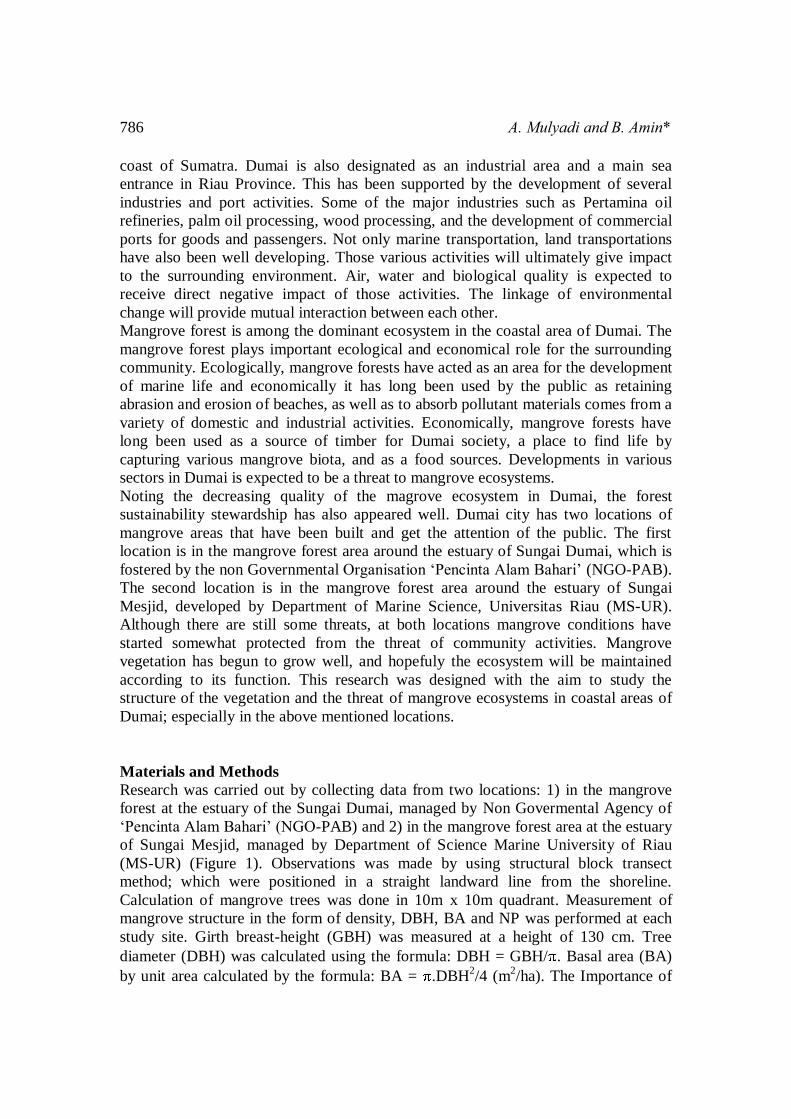
Research was carried out by collecting data from two locations: 1) in the mangrove
forest at the estuary of the Sungai Dumai, managed by Non Govermental Agency of
‘Pencinta Alam Bahari’ (NGO-PAB) and 2) in the mangrove forest area at the estuary
of Sungai Mesjid, managed by Department of Science Marine University of Riau
(MS-UR) (Figure 1). Observations was made by using structural block transect
method; which were positioned in a straight landward line from the shoreline.
Calculation of mangrove trees was done in 10m x 10m quadrant. Measurement of
mangrove structure in the form of density, DBH, BA and NP was performed at each
study site. Girth breast-height (GBH) was measured at a height of 130 cm. Tree
diameter (DBH) was calculated using the formula: DBH = GBH/ . Basal area (BA)
by unit area calculated by the formula: BA = .DBH2/4 (m
2/ha). The Importance of
Vegetation Structure and Mangrove Ecosystem Threats 787
Species (NP) was calculated by the formula: NP = density of one species/total density
x 100 + BA one species/SBA x 100 + frequency of one species/total frequency x 100
(Cintron and Schaeffer-Novelli in Mohammed et al., 2009; English et al., 1994). The
composition of the tree structure based on the diameter of the trunk, are grouped into
4 criteria, ie <4 cm, 4.1 to 9 cm, 9.1 to 20 cm, and >20.1 cm (Hinrichs, 2009).
Regression analysis was applied to evaluate the relationship between DBH with
mangrove tree height by looking at the r value, using the basic formula of Y = a + bX
(Mohammed et al., 2009). Mangrove stumps were calculated on 10 x 10 m quadrant,
and distinguished between logged stump to natural death stump. Identification and
density of existing solid waste around the mangrove forest areas was calculated on the
5m x 5m square. It was also identified a range of antrophogenic activities around the
studied area to estimate the threat sources to mangrove ecosystems.
Figure 1: Location of the study area in Dumai, Riau, Indonesia
Results and Discussion
Mangrove Vegetation structure:
Mangrove vegetation in the coastal area of Dumai city consisted of true mangrove and
secondary mangrove. Mulyadi (2009) found 13 species of true mangrove and 9
secondary mangrove species in Dumai. In another study, Efriyeldi (2012) revealed
that there are 5 dominant mangrove species in coastal area of Dumai ie. Avicennia alba, Bruguiera gymnorrhiza, Rhizophora apiculata, Sonneratia profit, Xylocarpus granatum. The present study found 4 true mangrove species were more dominant in
the coastal area of Dumai, namely A. alba, R. apiculata, S. alba and X. granatum. The
structure of the four different types of mangrove was different in both surveyed sites
(Table 1).
RUPAT
DUMAI
Malaysia
Sumatera,
Indonesia
= Dumai District
1
2
1
2
= Sungai Dumai
= Sungai Mesjid

788 A. Mulyadi and B. Amin*
Table 1: Structure of Mangrove in NGO-PAB and MS-UR Dumai
Location Species Mean
height
(m)
BA
(m2/ha)
Density
(tree/ha)
Relative
Density
Relative
Dominance
Relative
Frequency
NP
NGO-
PAB
A.alba R.apiculata
S.alba X.granatum
3.40
8.93
4.33
5.95
12.63
836.94
29.14
1,402.59
167
500
100
2.600
4.96
14.85
2.97
77.22
0.55
36.69
1.28
61.48
25.00
25.00
25.00
25.00
30.15
76.54
29.25
163.70
Marine
Science-
UR
A.alba R.apiculata X.granatum
4.20
18.32
10.04
59,77
1,767.61
446,26
100
1,467
900
4.05
59.46
36.49
2.63
77.74
19.63
14.29
42.86
42.86
20.97
180.06
98.98
Notes: BA = Basal Area NP = Important Value of Species
Mangrove of X. granatum was the most dominant species in the NGO-PAB with a
density of 2,600 trees/ha, BA 1402.09 m2/ha and NP 163.70; followed by R.
apiculata, A. alba and S. alba. With a density of 3,367 mangrove trees/ha in the
NGO-PAB Dumai, X. granatum compiled 77.22% composition followed by R. apiculata 14.85%, S. alba 4.96% and A. alba 2, 97%.
R. apiculata was the most dominant species in the mangrove area of MS-UR Dumai,
with a density of 1467 trees/ha, BA 1767.61 and NP 180.06. Of the total density of
2,467 mangrove trees/ha in the MS-UR Dumai, R. apiculata was compiled by
59.46%, X. granatum 36.49% and 4.05% of A. alba. Table 2 illustrates the
distribution of mangrove tree diameter in Dumai which was encountered during the
survey. A. alba found in both mangrove areas of NGO-PAB and MS-UR has a small
tree with a trunk diameter of less than 4 cm. Mangrove S. alba found in the NGO-
PAB, consisted of 33.33% on the size of the trunk diameter <4 cm and 66.67% of the
size of 4.1 to 9.0 cm.
Table 2: Percentage distribution of mangrove species classification based on the
diameter of the trees in the area of NGO-PAB and MS-UR Dumai, Riau.
Location Species D130 (cm)
<4 4,1-9 9,1-20 >20
NGO-PAB A.alba R.apiculata
S.alba X.granatu
100
6.67
33.33
25.64
-
33.33
66.67
32.05
-
26.67
-
28.92
-
33.33
-
1.28
Marine Science-UR A.alba R.apiculata X.granatum
100
2.27
3.37
-
29.55
70.37
-
68.18
25.93
-
-
-
Vegetation Structure and Mangrove Ecosystem Threats 789
R. apiculata identified during the study tended to have a larger size. In the area of
NGO-PAB, stem diameter of R. apiculata mostly scattered in diameter from 4.1 to 9
cm, 9.1 to 20 cm and >20 cm (33.33%, 26.67% and 33.33% respectively); whereas in
the MS-UR mostly at 4.1 to 9 cm and 9.1 to 20 cm (29.55% and 68.18 %
respectively). Likewise, the size of X. granatum trunk diameter was also tend to be
larger, especially when compared with A. alba and S. alba. In the area of MS-UR,
most X. granatum have a trunk diameter from 9.1 to 20 cm and >20 cm in the
composition of 70.37% and 25.93% respectively). Whilst in the NGO-PAB,
distribution of stem diameter and percentage of X. granatum were as follow: diameter
of <4 cm was found 25.64%, diameter of 4.1 to 9 cm (32.05%), 9.1-20 cm (28.92%)
and also found 1.28% with diameter of >20 cm.
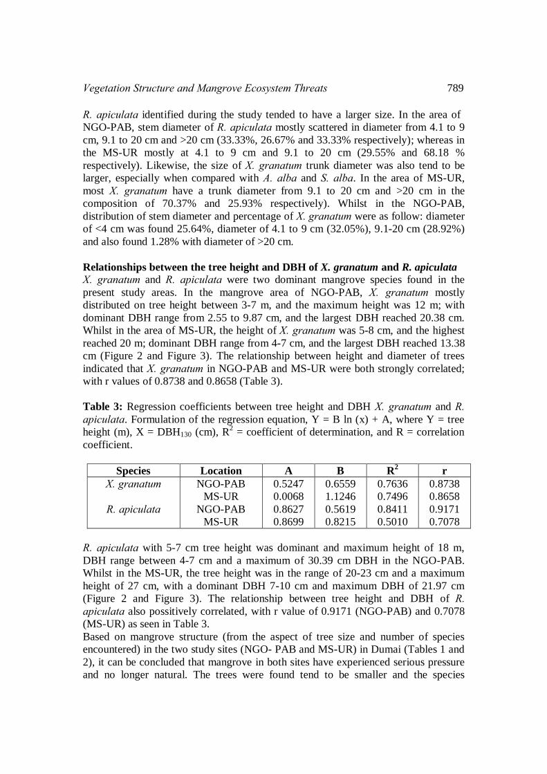
Relationships between the tree height and DBH of X. granatum and R. apiculata
X. granatum and R. apiculata were two dominant mangrove species found in the
present study areas. In the mangrove area of NGO-PAB, X. granatum mostly
distributed on tree height between 3-7 m, and the maximum height was 12 m; with
dominant DBH range from 2.55 to 9.87 cm, and the largest DBH reached 20.38 cm.
Whilst in the area of MS-UR, the height of X. granatum was 5-8 cm, and the highest
reached 20 m; dominant DBH range from 4-7 cm, and the largest DBH reached 13.38
cm (Figure 2 and Figure 3). The relationship between height and diameter of trees
indicated that X. granatum in NGO-PAB and MS-UR were both strongly correlated;
with r values of 0.8738 and 0.8658 (Table 3).
Table 3: Regression coefficients between tree height and DBH X. granatum and R. apiculata. Formulation of the regression equation, Y = B ln (x) + A, where Y = tree
height (m), X = DBH130 (cm), R2 = coefficient of determination, and R = correlation
coefficient.
Species Location A B R2 r
X. granatum
R. apiculata
NGO-PAB
MS-UR
NGO-PAB
MS-UR
0.5247
0.0068
0.8627
0.8699
0.6559
1.1246
0.5619
0.8215
0.7636
0.7496
0.8411
0.5010
0.8738
0.8658
0.9171
0.7078
R. apiculata with 5-7 cm tree height was dominant and maximum height of 18 m,
DBH range between 4-7 cm and a maximum of 30.39 cm DBH in the NGO-PAB.
Whilst in the MS-UR, the tree height was in the range of 20-23 cm and a maximum
height of 27 cm, with a dominant DBH 7-10 cm and maximum DBH of 21.97 cm
(Figure 2 and Figure 3). The relationship between tree height and DBH of R. apiculata also possitively correlated, with r value of 0.9171 (NGO-PAB) and 0.7078
(MS-UR) as seen in Table 3.
Based on mangrove structure (from the aspect of tree size and number of species
encountered) in the two study sites (NGO- PAB and MS-UR) in Dumai (Tables 1 and
2), it can be concluded that mangrove in both sites have experienced serious pressure
and no longer natural. The trees were found tend to be smaller and the species

790 A. Mulyadi and B. Amin*
encountered also has less diverse as a result of the tree has been selectively collected
by the public especially the larger sizes and specific type of mangrove. The same
conditions with this study have also occurred in Mombasa (Kenya) as reported by
Mohammed et al. (2009 ), where the mangrove species that frequently collected for
various purposes by the public are R. mucronata, A. marina, C. tagal and S. alba. When viewed from the aspect of tree density and their correlation coefficients, it can
be said that the condition of mangroves in both sites has improved, especially when
compared to the standard criteria for the determination of mangrove destruction by the
Minister of Environment of Indonesia No. 201, 2004. The regulatory standard stated
that the condition of mangrove forests are classified as good if it has a density of
>1,500 trees/ha, while in the second site mangrove density ranges between 2,467 and
3,367 trees/ha. This condition is estimated as the positive impact of both sites that are
under the supervision of NGO-PAB and MS-UR. Efriyeldi (2012) also revealed the
same condition of mangrove forests located beyond the estuary area of Sungai Mesjid
and in the estuary of Sungai Dumai were partly well maintained; while the condition
of the mangrove in Purnama has suffered serious damage. This is due to the location
of the mangrove in Purnama has an open acces and owned by the public, so that the
owner can take advantage of the mangrove area according to the needs and desires,
both to take advantage of mangrove trees or convert the area to agriculture and human
settlements. By contrast, in the estuary of Sungai Dumai and some parts of Sungai
Mesjid estuaries, NGO-PAB and MS-UR have been keeping and corserve the
mangrove and protected the areas from other uses.
Figure 2: The linear curve and log-log relationship between tree height and DBH
diameter of X. granatum (A and B) and R. apiculata (C and D) in the mangrove area
of NGO-PAB
(A) (B)
(C) (D)

Vegetation Structure and Mangrove Ecosystem Threats 791
Figure 3. The linear curve and log-log relationship between tree height and DBH
diameter of X. granatum (A and B) and R. apiculata (C and D) in the mangrove area
of MS-UR
Source of Threat and Impact of Mangrove Ecosystems
Threats to mangrove ecosystems sourced from both natural and anthropogenic factors.
Natural factors such as climate change, rising sea levels, changes in salinity which has
not been studied in detail in the mangrove areas of Dumai; therefore further study is
necessarily needed. The threat comes from antrophogenic activity according to Kumar
(2012) are pollution and logging, conversion into residential areas, agriculture,
plantation, fisheries, ports and industry. Adams et al. (2004) stated that the source of
the threat to mangrove ecosystems in Africa and the Philippines mostly comes from
the excessive use of wood (wood harvesting). The same conditions are also expected
to occur in mangrove areas of Dumai, where antrophogenic factors that contribute as a
threat to mangrove areas in Dumai such as domestic activities, marine transportation,
port activities and industry events.
Domestic activities
The main pollution source of domestic activities that pollute the environment around
mangrove areas in Dumai is wastes from residential, hotels and restaurants. Other
domestic activities such as shopping complexes, workshops, hospitals and market
activities are also believed to contribute significant wastes (PPLH of Riau and
Pertamina UP II Dumai, 2002). Wastes generated from those actitivities were also
varied, both in terms of physical form (solid, liquid and gas), and in terms of the
(A) (B)
(C) (D)

792 A. Mulyadi and B. Amin*
quality of wastes (organic and inorganic) and the quantity of the wastes itself.
Estimation of domestic wastes generated from a population can be calculated by the
method of rapid pollution assessment. If the entire population of each district in the
city of Dumai (Table 4) are expected as prime producer of wastes, then an illustration
of the wastes load to Dumai coastal areas is obtained as shown in Table 5.
Noting the data in Table 5 it can be said that the potential pollution source in the
marine and coastal areas of Dumai were quite large. Of the total population of
250,367 inhabitants in Dumai it was estimated to account for solid waste at 37,555.05
tons/year, the city waste of 100.15 tons/year and deposition waste at 3,004.40
tons/year.
Table 4: The total population according to the District of Dumai City
No District Population (Person)
1.
2.
3.
4.
5.
Bukit Kapur
Medang Kampai
Sungai Sembilan
Dumai Barat
Dumai Timur
9,894
36,928
26,644
89,088
87,813
Total 250,367
Table 5: Estimated Load of Waste Entering Dumai coastal waters*).
No. Type of Waste Factor **) (kg/person/year) Waste Load (ton/year)
1
2
3
City waste (solid)
City waste
Deposit
150
0.4
12
37,555.05
100.15
3,004.40
Total 40,659.60
Note *) Total Population According to the District of Dumai City (250,367 Life) X Factor **) Standard WHO, US-AFA
Industrial activities
According to PPLH (Environmental Research Center) of Riau and Pertamina UP II
Dumai (2002), industrial activities which produces contaminants in the coastal
environment of Dumai include metal industries, machinary and chemical industry as
well as agriculture and forestry industries. Table 6 illustrates some of industrial
enterprises operating in Dumai.
Table 6: The number of industrial enterprises operating in Dumai City
No. Industrial type Number (unit)
1.
2.
3.
Chemical, Agro and Forest Industries
Metal, Machinary and Electronic Industries
Small Industries and handycraft
315
260
415
Total 990

Vegetation Structure and Mangrove Ecosystem Threats 793
Dumai city is the base of the two national and international giant oil company PT.
Pertamina Persero UP II Dumai and PT. Chevron Pacific Indonesia. Both of these oil
companies process crude oil into fuel oil such as premium, aviation fuel, JP5,
kerosene, fuel oil, LSWR; and non-fuel products such as calcined coke, green coke,
LPG (Pertamina UP II Dumai, 2002). The production process at the refinery of
Pertamina UP II Dumai is supported by Dumai hydrocracker oil treatment plant and
installation supports, such as the accumulation tank, port/dock, residential/office,
workshop and others. PT. Chevron Pacific Indonesia make Dumai as hoarding
location (tank/pump) and shipment loading/unloading of oil products. This activity is
supported by the installation of tanks and port/dock. Environmental pollution from the
oil industrial activity is sourced from: oil processing, oil leaks and spills, facility
maintenance activities and supporting installation, boat maintenance activities, docks
and harbours.
Another large industry exist in Dumai is an industry that processes the CPO into its
derivatives such as cooking oil, olein and others. It is also found forestry industries
that process wood chips into wood powder and sawn timber; and a number of large
and small industries which produce a variety of products such as metal, electronics,
food, clothing, household appliances and daily necessities (BPS Dumai, 2010).
Various industrial activities that generate variety of pollutants such as solid, liquid or
gas, which is expected to affect the growth and life of a young or adult mangrove
trees. Pollution resulting from the activities of the existing industries in Dumai City
include solid waste both organic and inorganic, as well as liquid waste processing and
disposal of the remaining generators. Mangrove vegetation is very sensitive to the
wastewater and solid waste generated by the industry.
Marine Transportation and Ports
As an autonomous city that rely on industry, Dumai has representative local ferry and
freight port facilities to serve various sizes of boats. During 2009, public port facility
in Dumai turned into loading/unloading goods for commodities between islands;
where 11,910,904 tons loaded and 2,231,706 tons unloaded as well as 141, 612
passengers departed and 161, 486 passengers to come in; whilst abroad for goods as
much as 5,319,645 tonnes loaded and 306 222 tonnes unloaded and passengers:
138,553 passengers departed and 125,191 passengers to come in (BPS Dumai, 2010).
Port of Dumai City is also the port of export and import of various commodities
through both cargo ships and tankers. Moreover, in Dumai there are also special ports
owned by Pertamina UP II Dumai (6 units), PT. Chevron Pacific Indonesia (1 unit),
IPC (1 unit) and 6 units of warehouses.
Emerging threats to mangrove ecosystems from marine transportation and ports could
be sourced from leaks, spills of oil and ballast water; the maintenance of ships, docks
and harbours in the form of solid waste, sludge, chemicals and paints; as well as
domestic waste from the activities of the ports and ships. Mangrove vegetation is very
sensitive to oil pollution. Mangrove vegetation is also very easy to be affected and
will soon die if the environment is contaminated by oil. Aboudha and Cairo (2001)
explained that mangrove organisms, seagrass, algae and invertebrates will soon die in
association with the occurrence of oil contamination in the sediment. The mangrove

794 A. Mulyadi and B. Amin*
ecosystem has also very important ecological and physical function in ensuring the
survival of aquatic organisms and the stability of the shoreline. Because of its
ecological role, the existence of mangrove forest is closely related to the presence of
fishing fields. Thus, conservation of mangrove forests are very significant influence
on the economic sector of fishermen in the coastal waters of Dumai.
Activities in mangrove areas
Table 7 describes the identified antrophogenic activities at the NGO-PAB and MS-
UR mangrove areas. These activities include shipping, ports, construction of roads,
timber harvesting and piling, as well as the close proximity of human settlements in
both locations. The impact that may result from these activities include pollution, land
conversion and logging. More details will be discussed on the impact of various
antrophogenic activities in Dumai mangrove areas against logging and solid waste
pollution.
Table 7: The activities around Dumai mangrove areas, Riau
No Activities NGO-PAB MS-UR Impact
1.
2.
3.
4.
5.
6.
7.
Sea transportation
Ferry ports
Cargo and Freight ports
Settlements
Road construction
Piling
Timber harvesting
yes
yes
yes
5 meter
yes
yes
yes
yes
no
yes
5 meter
no
no
yes
P
P & L
P & L
P & T
P & L
L
T
Note: P = Pollution L = Land Conversion T = Timber logging
Mangrove logging
Impact of mangrove logging in Dumai mangrove areas sourced from timber logging.
Mangrove wood used by the community for the purpose of building, firewood,
charcoal and tools for fishing. Mangrove that are often utilized by people in Dumai
are Rhizophora, Xylocarpus, and Bruguiera. Aboudha and Cairo (2001) confirmed
that the type of vegetation such as Rhizophora, Xylocarpus, Heritiera, Bruguiera and
Ceriops frequently used by the community for firewood, charcoal, mast and home,
and taking the tannin for preservatives.
More dominant mangrove logging occurs at the location of NGO-PAB mangrove
areas when compared to the mangrove area in MS-UR. This indication can be seen
from the number of the mangrove stump found in the NGO-PAB areas (Table 8). Of
the total 15.33 stumps per 100m2 in Dumai mangrove areas, 11.33/100m
2 stumps
were identified in NGO-PAB mangrove area; and 4 stumps/100m2 in MS-UR
mangrove area of which two stumps were logged and 2 stumps were caused by
natural death.

Vegetation Structure and Mangrove Ecosystem Threats 795
Table 8: Average mangrove stumps in the area of NGO-PAB and MS-UR Dumai,
Riau
Location Number of Stump per 100m2
Logged Natural Total
NGO-PAB 11.33 - 11.33
MS-UR 2 2 4
Total 13.33 2 15.33
Solid waste pollution
Sources of pollution, especially solid waste in Dumai mangrove areas mostly come
from domestic activities. It also comes from the port and shipping activities as well as
industrial activities. Solid waste around mangrove areas of Dumai were identified in
the form of plastic, plastic bags, plastic bottles, styriofoam, wood and rubber. The
population of solid waste at both sites are 35.00 units / 100m2 for NGO-PAB and
11.67 units/100m2 on MS-UR mangrove area (Table 9).
Table 9: The type and density of solid waste (units / 100 m2) in NGO-PAB and MS-
UR mangrove areas Dumai, Riau
No Type of waste NGO-PAB MS-UR
1.
2.
3.
4.
5,
6.
Plastic
Plastic bag
Plasti botle
Styrioform
Wood
Rubber
3.33
9.67
1.67
2.67
4.33
3.33
-
3.33
4.67
1.00
2.00
0.67
Total 35.00 11.67
Judging from the composition and the total amount of solid waste found, it can be
estimated that the solid waste pollution threat is much greater in NGO-PAB mangrove
area when compared to mangrove area of MS-UR. Larger amount of solid waste in
the mangrove areas of NGO-PAB, which is located on the estuary of the Sungai
Dumai, was expected to come from the wastes of residential area along the river. In
addition, because of its closer location to the city center of Dumai, domestic activities
around the town are also thought to be a major contributor to the solid wastes at this
location. Table 10 illustrates the large population of Dumai which directly associated
with the studied area. Residents of Dumai Barat District, East Dumai and Medang
Kampai (213,829 inhabitants) is estimated to relate more closely and as a solid waste
contributor in NGO-PAB mangrove areas. Solid waste contributor to the MS-UR
mangrove area are largely thought to be originated from Dumai Barat District
residents and Sungai Sembilan (115,732 inhabitants). Waste load received by NGO-
PAB mangrove areas are much larger (34,725.81 tons/year) compared with MS-UR

796 A. Mulyadi and B. Amin*
mangrove area (18,794.87 tons/year). Biggest load of waste is in the form of solid
waste that ranges from 17,359.80 tons/year in MS-UR and 32,074.35 tons/year in
NGO-PAB, respectively (Table 11). The magnitude of the threat to NGO-PAB
mangrove areas (Sungai Dumai stuary) compared to the MS-UR mangrove area
(Sungai Mesjid estuary) was similar results as has been reported by Efriyeldi (2012)
who found that environmental conditions in MS-UR mangrove are more supportive
for the living of organisms than the estuary of Sungai Dumai where NGO-PAB
mangrove areas are located. Sungai Dumai estuary is very close to the port activity,
industrial area and urban centers that have high contribution of waste to the
surrounding environments.
Table 10: Estimated population in Dumai that directly associated with NGOs-PAB
and MS-PAB-UR mangrove area
No District Population (person)
1.
2.
3.
4.
5.
Bukit Kapur
Medang Kampai
Sungai Sembilan
Dumai Barat
Dumai Timur
9,894
36,928+)
26,644*)
89,088*+)
87,813+)
Jumlah 250,367
Note: +) Population that have direct association with NGO-PAB (36,928 + 89,088 + 87,813 = 213,829 person) *) Population that have direct association with MS-UR (26,644 + 89,088 = 115,732 person)
Table 11: Estimated load of waste in both NGO-PAB and MS-UR Dumai.
No. Type of waste Factor *)
(kg/person/year)
Waste load
(ton/year) **)
NGO-PAB
Waste load
(ton/year) ***)
MS-UR
1
2
3
Urban waste (solid)
Urban waste
(Piled)
150
0.4
12
32,074.35
85.53
2,565.93
17,359.80
46.29
1,388.78
Total 34,725.81 18,794.87
Note *) WHO Standard, US-EFA **) Total Population Region NGO-PAB (213 829) X Factor ***) Region Population IK-UR (115 732) X Factor
Conclusions
The structure of mangrove in Dumai coastal areas was dominated by R. apiculata
especially in MS-UR and X. Granatum in NGO-PAB areas. Greater threat on
mangrove forests was identified in NGO-PAB than MS-UR mangrove areas. Most of
R. apiculata and X. granatum population in Dumai has stem diameter greater than 9
cm. Both types of mangrove growth normally, where the relationship between stem
diameter (DBH 130cm) and stem height was possitively correlated with r value of

Vegetation Structure and Mangrove Ecosystem Threats 797
0.7078 to 0.91 for R. apiculata and 0.8656 to 0.8738 for X . granatum. The source of
antrophogenic threat to Dumai mangrove ecosystem comes from domestic activities,
industry, marine transportation and port activities, human settlement, development of
infrastructure and timber extraction. Mangrove logging and solid waste deposition is
predominantly found in the NGO-PAB compared to MS-UR mangrove area.
Acknowledgements
The author thanks to the University of Riau who provided funding for this research.
Sincere thank also goes to NGO-PAB and MS, UR who has facilitated the authors in
the collection of data in those mangrove areas. Many thanks also conveyed to all
those who have assisted authors in the completion of this research.
Reference
[1] Aboudha P.A.W. And Kairo, J. G. 2001. Human-induced stress on mangrove
swamps along the Kenyan coast. Hydrobiologia 458: 255-265.
[2] Adams, J. B, B, Colloty, M And Bate, G. C. 2004. The distribution and state
of mangrove along the coast of Transkei, Eastern Cape Province, South
Africa. Wetland Ecology and Management 12: 531-541.
[3] Amarasinghe, M. D. And Balasubramaniam, S. 1992. Structural properties of
two types of mangrove stands on the northwestern coast of Srilangka.
Hydrobiologia 247: 17-27.
[4] BPS (Badan Pusat Statistika) Kota Dumai. 2010. Dumai Dalam Angka Tahun
2010.
[5] Chasang, H. 1984. Structure of a mangrove forest at Ko Yao Yai, Southern
Thailand. In: Soepadmo E, Rao AN, Macintosh DJ (eds) Proceedings of the
Asian symposium on mangrove environment research and management. Kuala
Lumpur 1980. University of Malaya and UNESCO.
[6] Efriyeldi. 2012. Ekobiologi kerang sepetang (Pharella acutidens Broderip &
Sowerby, 1828) di ekosistem mangrove pesisir Kota Dumai, Riau. Disertasi
Sekolah Pascasarjana IPB, Bogor.
[7] English, S., Wilkinson, C. And Baker, V. 1994. Survey manual for tropical
marine resources. Australian Institute of Marine Science, Townsville.
[8] Hinrichs, S., Nordhaus I., And Geist, S.J. 2009. Status, diversity and
distribution patterns of mangrove vegetation in the Segara Anakan lagoon,
Java, Indonesia. Reg Environ Change 9:275–289.
[9] Kumar, P. 2012. Impact of economic drivers on mangroves of Indian
Sundarbans: an exploitation of missing links. Env. Dev. Suatain 14: 939-953.
[10] Mohamed, M. O. S., Neukermans, G., Kairo, Dahdouh-Guebas, J. G, F. And
Koedam, N. 2009. Mangrove forests in a peri-urban setting: the case of
Mombasa (Kenya). Wetland Ecology and Management (17): 243-255.
798 A. Mulyadi and B. Amin*
[11] Pool, D. J., Snedaker, S.C. And Lugo, A. E. 1977. Structure of mangrove
forests in Florida, Puerto Rico, Mexico and Costa Rica. Biotropica 9(3):195–
212. doi:10.2307/2387881.
[12] PPLH UNRI (Pusat Penelitian Lingkungan Hidup Universitas Riau) dan
Pertamina UP II Dumai. 2002. Sensitivitas Kawasan Pesisir Dumai. Laporan
Penelitian.
[13] Reise, A. 2003. Estimates of biomass and productivity in fringe mangroves of
North-Brazil. ZMT-contribution 16, Bremen.
Top Related