


Languages
Pages
Legal


PRELIMINARY PROGRAM
www.surveyingconference.org
Surveying: A Foundation to Sustainable Infrastructure Development
UESI 2018 Surveying & Geomatics ConferencePomona, California | April 22-24

2 Surveying: A Foundation to Sustainable Infrastructure Development
Schedule at a Glance
ContentsSchedule at a Glance .........................................2A Welcome from the Conference Chair ..............3Conference Program Committee .........................3Pre-Conference Workshops ................................4Program Highlights ............................................5Technical Program ..........................................6-7Registration Information .....................................8Hotel, Travel & General Information....................9
Sunday, April 228:00 a.m. – 2:00 p.m. Registration8:00 a.m. – 5:00 p.m. Committee Meetings8:00 a.m. – 5:00 p.m. Pre-Conference Workshops
Monday, April 237:00 a.m. – 5:00 p.m. Registration8:00 a.m. – 9:05 a.m. Open Remarks Keynote Speaker9:15 a.m. – 10:10 a.m. Concurrent Technical Sessions I10:15 a.m. – 6:30 p.m. Exhibit Hours10:15 a.m. – 10:55 a.m. Networking Break in Exhibit Hall11:00 a.m. – 11:55 a.m. Concurrent Technical Sessions II12:00 p.m. – 1:40 p.m. Lunch & Keynote Speakers1:45 p.m. – 2:40 p.m. Concurrent Technical Sessions III2:45 p.m. – 3:25 p.m. Networking Break with Exhibitors3:30 p.m. – 4:50 p.m. Concurrent Technical Sessions IV5:15 p.m. – 6:30 p.m. Reception with Exhibitors
Tuesday, April 247:00 a.m. – 10:00 a.m. Registration 7:30 a.m. – 8:30 a.m. Breakfast 8:30 a.m. – 9:45 a.m. Concurrent Technical Sessions V9:50 a.m. – 11:00 a.m. Exhibit Hours9:50 a.m. – 10:35 a.m. Networking Break with Exhibitors10:40 a.m. – 12:05 p.m. Concurrent Technical Sessions VI12:10 p.m. – 1:25 p.m. Lunch & Keynote Speaker1:20 p.m. – 2:00 p.m. ASCE Surveying and Mapping Award2:05 p.m. – 2:55 p.m. Concurrent Technical Sessions VII3:00 p.m. – 3:15 p.m. Afternoon Break 3:15 p.m. – 4:00 p.m. The Future of Surveying / Closing Session

3
Gateways to a World of Opportunities
www.surveyingconference.org 3
Welcome from the Conference ChairsIt is with great pleasure that we welcome you to Cal Poly Pomona for the Utility Engineering and Surveying Institute 2018 Surveying and Geomatics Conference. In the spirit of the educational objectives of our geospatial engineering program, it is our goal to bring surveyors and engineers together. This conference will be a rich venue for discussions in a wide range of subjects linking surveying and engineering, specifically in applications to sustainable infrastructure development. The program offers two pre-conference workshops, and over 50 technical paper presentations split in three parallel sessions. Four keynote speaker sessions will address surveying in land development projects, licensing, natural disasters, and the future of surveying.
We expect that your active participation in the discussions for each presentation will contribute to shape and advance how surveying and engineering interact to solve infrastructure problems with impact to societal and economical problems.
The networking opportunities will extend to experts from all over the country and exhibitors, with a reception on Monday evening. This conference will sure be a great avenue to connect with old and new friends from very diverse professional backgrounds.
The ASCE Surveying and Mapping Award, established in 1969, has in the past been awarded annually in other venues. The 2018 Award will be bestowed on the second day of the conference.
Finally, we invite you to come enjoy spring in Southern California, along with all the prospects that the region has to offer. Cal Poly Pomona campus is an effervescent haven on the edge of Los Angeles, Orange and San Bernardino counties, with very close proximity to Riverside county. Participants will be able to engage in a bubbling and very diverse student body, as well as take advantage of the nearby tourist attractions.
We look forward to meeting you in April 2018!
Welcome to 2018 Surveying & Geomatics Conference
Conference Co-ChairsFrancelina Neto, Ph.D, PLS, M.ASCE Cal Poly PomonaAllan Ng, PLS, M.ASCE Cal Poly Pomona
Technical Program ChairAhmed Elaksher, Ph.D, PLS, Aff. M.ASCE Cal Poly Pomona
Track ChairsDavid Garber, P.E., PLS, F.ASCE Garber-Chilton Engineers & Land Surveyors IncTom Pilarski, PLS, M.ASCE PsomasJ.P. Mohsen, Ph.D, F.ASCE University of Louisville
Education CommitteeCarol Morman, P.E., PLS, M.ASCE, Chair Cincinnati State Technical and Community CollegeJoseph Paiva, Ph.D, P.E., PLS, M.ASCE Cadastral Consulting, LLCOmar Mora, Ph.D, Aff. M.ASCE Cal Poly Pomona
Journal of Surveying Engineering, EditorMichael Olsen, Ph.D, Aff. M.ASCE Oregon State University
AAGS LiaisonsDaniel Gillins, Ph.D, PLS, M.ASCE NOAA/National Geodetic SurveyMichael Dennis, RLS, P.E., M.ASCE NOAA/NOS/National Geodetic Survey
UESI Board of Governors LiaisonDavid Totman, Aff. M.ASCE President Elect, UESI
ASCE Sponsorship and Exhibit SalesSean Scully Manager, Sponsorship and Exhibit Sales
Utility Engineering & Surveying Institute (UESI) of ASCEJohn Segna, P.E., F.ASCE Director, UESISusan Reid, MBA, Aff.M.ASCE Manager, UESICristina Charron Manager, Conferences & Meetings
Allan Ng, PLS, M.ASCE Cal Poly Pomona
Francelina Neto, Ph.D, PLS, M.ASCE Cal Poly Pomona

4 Surveying: A Foundation to Sustainable Infrastructure Development
PreConference Workshops
Sunday, April 22Ground Truth for the Future: Low Distortion Projections and the State Plane Coordinate System of 20228:00 a.m. – 12:00 p.m.Map projections are distorted — it is a Fact of Life. The crux of the problem is linear distortion: the difference between true horizontal “ground” distance and its projected representation. This difference often exceeds 1 foot per mile (20 cm/km) for State Plane and other existing published coordinate systems. Such linear distortion can be problematic for various geospatial products and services, including engineering plans, survey plats, construction staking, as-built surveys, and facilities management. Linear distortion cannot be eliminated, but it can be minimized using low distortion projections (LDPs) – although some situations can prove challenging for designing LDPs that perform satisfactorily. This workshop shows how LDPs can be designed to achieve optimal performance even over relatively large areas with variable topographic relief. Importantly, the design procedures are based on the same conformal map projection types used for the new State Plane Coordinate System of 2022 (SPCS2022): Lambert Conformal Conic, Transverse Mercator, and Oblique Mercator. The workshop also provides an overview of the history of State Plane and current plans for development of SPCS2022, including proposed options for states and territories to adopt LDPs as part of SPCS2022. Beyond consistency with SPCS2022, another benefit of using those existing map projection types is that they are compatible with engineering, surveying, and GIS data. Because they can be rigorously georeferenced, LDPs can be used directly to represent conditions “at ground” in GIS and CAD platforms. A resulting notable benefit is that LDP datasets can coexist with other geospatial data without resorting to approximate “best-fit” transformations or other “rubber-sheeting” acts of desperation.
Primary Objectives
• Explain map projection concepts to enable evaluation of projection types and characteristics that are most suitable for surveying and engineering applications
• Give overview of the State Plane Coordinate System of 2022 (SPCS2022), including the history State Plane, plans for SPCS2022, and the role of LDPs in SPCS2022
• Provide detailed methods for designing LDPs that optimally minimize linear distortion
• Describe characteristics of various existing methods for minimizing map projection distortion and how to evaluate their performance
• Show how to make use of existing LDPs in their software and workflows
• Discuss documenting LDPs to facilitate data transferability
Workshop Lead & Speaker: Michael Dennis, RLS, PE, M.ASCE, NOAA/NOS/National Geodetic Survey
Registration: $100
ASCE Standard 38-02: Substructure Utility Location: The Design, the Engineer, and the Surveyor1:00 – 5:00 p.m.ASCE Standard 38 is a guideline for the collection and depiction of existing subsurface utility data. The collection and depiction or the lack of collecting and depicting of subsurface utility data can positively or negatively affect the design of a project. In this presentation, we will have a brief overview of ASCE Standard 38-02 and look at substructure utility locating from 4 perspectives. In the overview of ASCE Standard 38-02 we will discuss how following this guideline can make it easier for the engineer, the surveyor and the subsurface utility detector to locate, mark out, map and design a project. By walking through a project, we will present the design perspective from the engineer and how the location of subsurface utilities can assist them in their design We will discuss the Land Surveyors perspective on how the locating of subsurface utilities can easily be done in the mapping phase. We will also look at the substructure utility locator’s perspective on the utility locating tools that are available and the accuracies one can expect from those tools. We also will discuss the perspective of the licensing board for the State of California and how they view substructure location and mapping. The intent of this presentation would be to show how the locating of utilities up front in the mapping phase of a project, you can reduce RFI’s in the construction phase of a project.Speakers:
Tom Pilarski, PLS, M.ASCE, Psomas David Moritz, PLS Anissa Voyiates, P.E. Richard Moore, PLS Matthew Wolf
Registration: $100
Sign Up for Both Workshops and Save
Registration bundle rate for morning and afternoon workshops: $150 (listed as full day pricing in Event Brite).

Monday, April 23
Open Remarks & Keynote Speaker8:00 a.m. – 9:05 am.
KEYNOTE SPEAKER
The Benefit of Surveying Knowledge in Land Development ProjectsThis presentation will focus on how having a career in civil engineering can be self-rewarding and financially lucrative. However, given changes in conditions of the economy, the industry can be cyclical in nature. With our fast-changing world in science and technology, it is important to remain open, flexible, and willing to re-tool your skills in order to remain competitive in the future.
Fabrizio Pachano, P.E., PLS, Senior Civil Engineer, LADPW
Fabrizio Pachano, PE, LS, is a senior civil engineer with the Los Angeles County Department of Public Works. Pachano has over 30 years of civil engineering and land surveying experience in both the private and public sectors. Pachano is a registered civil engineer, a licensed land surveyor, and holds a
general contractor’s license, all in the State of California. Pachano has a Bachelor of Science in Civil Engineering from Cal Poly Pomona and a Master’s in Business Administration from Cal State Los Angeles with an emphasis in finance.
Lunch & Keynote Speakers12:00 p.m. – 1:40 p.m.
KEYNOTE SPEAKERS
Collection and Depiction of Existing Subsurface Utility Data – Do I need a license for that?This presentation will explore national guidelines associated with people and firms performing the collection and depiction of existing subsurface utility data and will emphasize the ASCE C-I 38-02, Standard Guidelines for the Collection and Depiction of Existing Subsurface Utility Data and how that compares to the NCEES Model Law and Model Rules for engineering and surveying. Subsurface Utility Engineering (SUE) provides valuable information upon which important future engineering design decisions are formulated. Highlights of the presentation include the requirements that practitioners of SUE should comply with at national, state and professional society levels. Paramount to all SUE services is protection of the public. We will discuss a professional’s standard of care, level of responsibility for each step of the work, and the challenges newly faced with anticipated deregulation of occupational licensing around the country.
Richard Moore, PLS, Executive Officer of California BPELSG
After working in the land surveying profession for more than 30 years, Ric Moore began working at BPELSG in 2007 when he contracted as the Land Surveyor Consultant to what was then BPELS. In 2009, he joined staff by assuming the newly formed Senior Registrar Land Surveyor position. After managing the
licensing examination operations of the Board, Moore was appointed by the Board to be the BPELSG Executive Officer in July 2011.
Patrick Tami, PLS, President, NCEES; Principal and Office Survey Operations Manager, R.E.Y. Engineers, Inc.
Pat Tami, a Professional Land Surveyor for over 30 years, is the 2017-2018 President of the National Council of Examiners for Engineering and Surveying (NCEES). Tami is a nationally recognized expert in land surveying laws, regulations, and standards. He was appointed three times by California Governors
to the California Board for Professional Engineers, Land Surveyors and Geologist, serving from 2006 to 2016.
Reception with Exhibitors5:15 p.m. – 6:30 p.m. Be among the first to see innovations in the industry by attending the reception with your exhibitors. Join colleagues and friends in the exhibit area for this opportunity to network and make valuable future contacts. Visit the exhibits and discuss solutions to the challenges facing you in your daily life.
3
Gateways to a World of Opportunities
www.surveyingconference.org 5
Program Highlights

Tuesday, April 24
Lunch & Keynote Speaker12:10 p.m. – 1:25 p.m.
KEYNOTE SPEAKER
Extreme Natural Event Research Applications of Terrestrial Laser Scanning (TLS) and Structure-From-Motion (SFM) TechnologiesGeosystems civil engineering is an empirically-driven field that relies heavily on observation to validate analytical models used to predict ground failure. Toward that objective, natural disaster rapid-response research has benefited greatly from the advent of terrestrial LIDAR scanning technology (TLS) and Structure-From-Motion (SFM) interpretation of imagery collected using unmanned aerial systems, both revolutionary tools for characterizing fine-scale changes in topography. For civil engineering research, TLS and SFM have been particularly useful for characterizing the dimensions of failures and for monitoring subtle deformations through time. This talk will present examples of the use of TLS and SFM in extreme event investigations of damage from earthquakes and hurricanes, and an evaluation of the accuracy, bias, and dispersion of TLS and SFM data under controlled experimental conditions. Field applications of TLS and SFM are presented for damage visualization and analysis of recent events including 2016 Kumamoto earthquakes, the 2016 central Italy Amatrice and Norcia earthquakes, and damage to Guajataca dam during the 2017 Hurricane Maria event. Detailed understanding of the ground surface morphology allows for better numerical modeling of potential failure modes, deformation patterns, and morphologies. Finally, TLS and SFM allow for the permanent archiving of 3-D terrain models.
Robert Kayen, P.E., Civil & Environmental Engineering, Industry Faculty, UCLA; Senior Scientist & Research Civil Engineer, USGS
Robert Kayen is a civil engineer, geologist, and professor of civil engineering and environmental engineering at the University of California, Los Angeles, Industry Faculty, and a senior scientist at the United States Geological Survey. He is a leading international expert in the fields
of earthquake engineering, soil liquefaction, and ground failure. Kayen’s research focuses on geotechnical engineering, engineering characterization of natural hazards and extreme events, and earth science aspects of civil engineering. His works have been applied in earthquake engineering design of building foundations, bridge abutments, and lifeline and environmental systems.
2018 ASCE Surveying and Mapping Award1:20 p.m. – 2:00 p.m. Established in October 1969, the award is made annually to an individual who has made a definite contribution during the year to the advancement of surveying and mapping either in teaching, writing, research, planning, design, construction or management, these contributions being made in the form of papers or other written presentations, or in some instances through notable performance, long years of service, or specific actions which have served to advance surveying and mapping.
Closing Plenary Session: The Future of Surveying 3:15 p.m. – 4:00 p.m. Speakers: Carol Morman, P.E., PLS, M.ASCE Patrick Tami, PLS
6 Surveying: A Foundation to Sustainable Infrastructure Development
Program Highlights (continued)
3
Gateways to a World of Opportunities
www.surveyingconference.org 7
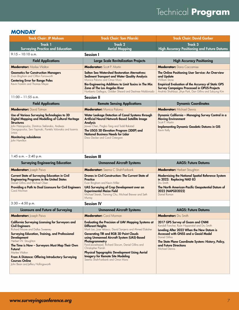
Technical Program
MONDAYTrack Chair: JP Mohsen Track Chair: Tom Pilarski Track Chair: David Garber
Track 1 Surveying Practice and Education
Track 2 Aerial Mapping
Track 3 High Accuracy Positioning and Future Datums
9:15 – 10:10 a.m. Session IField Applications Large Scale Revitalization Projects High Accuracy Positioning
Moderator: Marlee Walton Moderator: Scott P. Martin Moderator: Dana Caccamise
Geomatics for Construction Managers Evan Bingham and Clifton Farnsworth
Centering Error for Range Poles Kevin Franklin and Thomas Meyer
Salton Sea Watershed Restoration Aternatives: Sediment Transport and Water Quality Analysis Monica Palomo and Omar Mora
Bio-Engineering Additions to Limit Toxins in The Mix Zone of The Los Angeles River Humberto Gallegos, Golden Sheard and Destinee Maldonado
The Online Positioning User Service: An Overview and Update William Stone
Empirical Evaluation of the Accuracy of Static GPS Survey Campaigns Processed in OPUS-Projects Anahita Shahbazi, Jihye Park, Dan Gillins and Sukyung Kim
11:00 – 11:55 a.m. Session IIField Applications Remote Sensing Applications Dynamic Coordinates
Moderator: David Totman Moderator: Monica Palomo Moderator: Michael Dennis
Use of Various Surveying Technologies to 3D Digital Mapping and Modelling of Cultural Heritage Structures John Hatzopoulos, Dimitrios Stefanakis, Andreas Georgopoulos, Sevi Tapinaki, Pantelis Volonakis and Ioannis Liritzis
Monitoring subsidence John Hamilton
Water Leakage Detection of Canal Systems through Artificial Neural Network-Based Satellite Image Analysis Jiawei Chen, Pingbo Tang and Todd Rakstad
The USGS 3D Elevation Program (3DEP) and National Business Needs for Lidar Drew Decker and Carol Ostergren
Dynamic California – Managing Survey Control in a Moving Environment Scott P. Martin
Implementing Dynamic Geodetic Datums in GIS Kevin Kelly
1:45 a.m. – 2:40 p.m. Session IIISurveying Engineering Education Unmanned Aircraft Systems AAGS: Future Datums
Moderator: Joseph Paiva Moderator: Seema C Shah-Fairbank Moderator: Herbert Stoughton
Current State of Surveying Education in Civil Engineering Programs in the United States Daniel Gillins and Michael Olsen
Providing a Path to Dual Licensure for Civil Engineers Carol Morman
Drones in Civil Construction: The Current State of Practice Evan Bingham and Kevin Miller
UAS Surveying of Crop Development over an Experimental Maize Field Michael Starek, Tianxing Chu, Michael Brewer and Seth Murray
Modernizing the National Spatial Reference System in 2022: Replacing NAD 83 Dru Smith
The North American-Pacific Geopotential Datum of 2022 (NAPGD2022) Daniel Roman
3:30 – 4:50 p.m. Session IVLicensure and Future of Surveying Unmanned Aircraft Systems AAGS: Future Datums
Moderator: Joseph Paiva Moderator: Carol Morman Moderator: Dru Smith
California Surveying Licensing for Surveyors and Civil Engineers Richard Moore and Dallas Sweeney
Surveying Education, Training, and Professional Development Herbert W. Stoughton
The Time is Now – Surveyors Must Map Their Own Future! Marlee Walton
From A Distance: Offering Introductory Surveying Courses Online John Bean and Jeffery Hollingsworth
Evaluating the Precision of UAV Mapping Systems at Different Heights Mark Lao, Jose Velasco, David Sanjenis and Ahmed Elaksher
Generating TIR and RGB 3D Point Clouds using Unmanned Aircraft System (UAS)-Based Photogrammetry Farid Javadnejad, Richard Slocum, Daniel Gillins and Christopher Parrish
Physical Topographic Development Using Aerial Imagery for Remote Site Modeling Seema Shah-Fairbank and Omar Mora
2017 GPS Survey of Guam and CNMI Kendall Fancher, Ryan Hippenstiel and Dru Smith
Leveling After 2022 When the New Datum is Accessed with GNSS and a Geoid Model Daniel Gillins
The State Plane Coordinate System: History, Policy, and Future Directions Michael Dennis

8 Surveying: A Foundation to Sustainable Infrastructure Development
Technical Program (continued)
TUESDAYTrack 1
Laser Scanning and Mobile MappingTrack 2
Utility and Subsurface SurveyingTrack 3
Applied Surveying8:35 – 9:45 a.m. Session V
Mobile Mapping Utility and Subsurface Surveying Emergency Response
Moderator: Jorge Chen Moderator: Omar E. Mora Moderator: Steven J. Martin
Embrace Land Mobile Mapping for Smarter Cities Stefania Radopoulou and Rui Wu
High Resolution Multi-Lane Road Surface Mapping Using 3D Laser Profilers John Laurent and Benoit Petitclerc
Progress Monitoring of Horizontal Construction Projects Using Mobile LiDAR Point Clouds Nisha Puri and Yelda Turkan
Subsurface Utility Infrastructure Data in the Survey Environment Shawn Clark
Some Challenges in Delivering 3-D Subsurface Utility Model Alec Grkovic
Precision Inertial GNSS and Direct Georeferencing of Multichannel Ground Penetrating Radar for Highway Applications William Owen, John Gilmore, Kin Yen, Momoh Mallah and Mark Turner
Hydrographic and Underwater Surveying after Natural Disasters Terence Browne, Roy Forsyth and Chris Hartzell
NOAA NGS Emergency Response Imagery for the 2017 Hurricane Season: Technologies, Capabilities, and Challenges Mike Aslaksen, Jon Sellars and Jason Woolard
Surveying/Geomatics and GIS Response for the California Oroville Dam Emergency Daniel K. Mardock
Track 1 Terrestrial Laser Scanning
Track 2 Utility and Subsurface Surveying
Track 3 Boundary Surveying Topics
10:40 a.m. – 12:05 p.m. Session VIModerator: Daniel Gillins Moderator: Omar E. Mora Moderator: Dana Caccamise
Assessing Different Point Cloud Geo-Referencing Procedures Luis Landaverde, Mohammed Algasem, Ahmed Elaksher and Tarig Ali
Georeferencing 3D Indoor Maps Using Point Cloud Registration Jorge Chen
Fast Segmentation of Terrestrial Laser Scans based on Normal Variation Analysis Erzhuo Che and Michael Olsen
Technological Advances in Pipeline Mapping Neal McPherson, Matt Okubo, Doug Pluta, Rich Josenhans and Omar Mora
Integration of Mobile LiDAR and SUE Technologies Paul DiGiacobbe
Integration of Advanced 3D Subsurface Utility Engineering Information, A Model for the Future Matthew Wolf, Robert Vasquez and Jorgen Bergstrom
Boundary Survey: How to Deal with Boundary Dispute Issues Avinash Prasad and Purnima Prasad
Deed: How to Deal with Ambiguous Legal Deed Descriptions Avinash Prasad and Purnima Prasad
The Torrens Land Boundary System: A Legal Revolution That Complements the Ongoing Geomatics Technological Revolution William Bowie
Track 1 BIM
Track2 Utility and Subsurface Surveying
Track 3 Inspection Surveying
2:05 – 2:55 p.m. Session VIIModerator: Jin Sung Cho Moderator: Humberto Gallegos Moderator: Terrence Browne
Quality Assessment for Concrete Work Using Laser Scanning Technology: “2 & U in Seattle “ and “ Portland State University of Business” Greg Smith and Jinsung Cho
Laser Scanning for Above Ceiling MEP Systems and Mechanical Rooms: “ Genentech, Hillsboro, OR and Hollywood Presbyterian Medical Center, LA, CA” Greg Smith and Jinsung Cho
The Intersection of Utility Surveying & Engineering Jesse Cooper
SUE – Is it an Engineering Practice, or a Survey Practice? When is it both? Gregory Jeffries
Automated Surveying of Pardee and Camanche Dams Steven Martin
Using Web GIS Platform for Bridge Inspection Inventory Management Farid Javadnejad, Daniel Gillins, Christopher Higgins and Matthew Gillins

Registration HoursSunday, April 22 8:00 a.m. – 2:00 p.m.Monday, April 23 7:00 a.m. – 5:00 p.m. Tuesday, April 24 7:00 a.m. – 10:00 a.m.
Registration RatesEarly Bird (Ends 2/16/2018)ASCE/UESI Member $350 Non-Member $485Speaker/Moderator* $350Full-Time Student $100*Speakers have to register by February 15, 2018 to ensure inclusion in the Final Program.
Regular (After 2/16/2018)ASCE/UESI Member $450 Non-Member $585 Full-Time Student $100
On Site (After 4/21/2018)ASCE/UESI Member $550Non-Member $685Full-Time Student* $100* Full-time Students must present valid identification on-site at registration desk when picking up name badge.
Register OnlineThe registration process is being handled by Cal Poly Pomona. Please use this link to register online:EventBrite https://www.eventbrite.com/e/asce-uesi-2018-surveying-geomatics-conference-tickets-36627276169
For further questions please contact:Allan Y. Ng, P.L.S. – Conference Co-chairAdjunct Professor,Civil Engineering Department,California State Polytechnic University [email protected]
Payment by CheckOn the Registration page, under “Order Now”. Click “Show other payment options” and “Pay Offline”. You can register as normal and send a check with the following information.
Make the check payable to:Cal Poly Pomona Foundation, Inc.Note: UESI 2018 Surveying & Geomatics Conference
Mail the check to:Attn: Allan NgCivil Engineering Department,3801 W. Temple Ave.,Pomona CA 91768
Refund PolicyRefunds for cancellation will be made if requested in writing 30 days prior to event and are subject to a $35 cancellation fee. Please contact us at [email protected] to discuss.
Receive Member RatesNot a member of ASCE? Join today and save on your UESI 2018 Surveying & Geomatics
Join UESI and Save!
Simply visit www.asce.org/join or call (800) 548-ASCE (2723) to request an application. For more information on member benefits, go to www.asce.org/membership. You must be a member in good standing to qualify for the member rates.
Early Bird Registration Discount (EB)Don’t miss out! Register early and receive the best savings. The deadline for Early Bird registration is Friday, February 16, 2018. Registration online must include complete payment and be RECEIVED by this date to qualify for the Early Bird registration discount.
Regular Registration Discount (REG)We invite registrants to take advantage of this advance registrationdiscount. The deadline for regular registration is Saturday, April 21, 2018. Registration online must include complete payment information, and must be RECEIVED by this date to qualify for this discount.
On-Site Registration (ONS)On-site registration starts Sunday, April 22, 2018.
Confirmation of RegistrationConfirmation will be e-mailed to all Early Bird and Regular registrants following online submission of the registration information. Pre-registered attendees will receive their name badges and any tickets ordered at the on-site Registration Desk during Registration hours.
Program and Session CancellationWe reserve the right to cancel programs and/or sessions because of low registration. In the unlikely event of a cancellation, all registrants will be notified and will receive a full refund, if applicable. Programs and Sessions are subject to change, and we reserve the right to substitute a program, session, and/or speaker of equal caliber to fulfill the educational requirements.
Sponsor the Conference!Show your support of Pipelines 2017 Conference by becoming a sponsor. Contact Sean Scully at [email protected] or 703-295-6154 for more information.
3
Gateways to a World of Opportunities
www.surveyingconference.org 9
Registration Information

10 Surveying: A Foundation to Sustainable Infrastructure Development
Hotel, Transportation & General Information
HotelKellogg West Conference Center & Hotel3801 W. Temple AvenuePomona, CA 91768
Uniquely located on a wooded hilltop overlooking cereal magnate W.K. Kellogg’s former ranch estate, Kellogg West Conference Center & Hotel @ Cal Poly Pomona offers the perfect backdrop for meetings, conferences and special events. Located 90 minutes from downtown Los Angeles and 15 minutes from Ontario International Airport, Kellogg West offers a relaxing and distraction-free setting for any event or venue.Contracted room rates for this event will be $95 for single and $105 for double rooms. All pricing is subject to tax.Group rate will be available starting January 10, 2018. To reserve a room please call (800) 593-7876.
Transportation & Parking AirportsOntario International Airport – 17 Miles (25 minutes) from Cal Poly Pomona Los Angeles International Airport – 47 miles (1.5mhours) from Cal Poly Pomona
Burbank Airport – 42 miles (1.1 hours) from Cal Poly Pomona
John Wayne – Orange County Airport – 31 miles from Cal Poly Pomona Airport Transfers
Complimentary transfers for hotel guests only are also available via Kellogg shuttle. Please call the center with your travel information one day in advance to reserve the Ontario Airport Shuttle Service at (800) 593-7876.
Parking Park at any student parking locations in parking structure II. Parking permit can be obtained from Parking Information Booth or automatic parking permit vending machine. Fee is $9 per day.
General InformationAttireThe dress code for the Conference is business casual (i.e. slacks, casual dresses). Meeting room temperatures will vary, so wear layered clothing to ensure your personal comfort. We also recommend attendees wear comfortable shoes. Please note that certain events may have specific details on attire, and you should refer to the description of that event for more information.
Badge Policy and RibbonsYour name badge is your admission to the Conference. Please wear your badge at all times while at the conference. Ribbons will be available at the Registration desk. ASCE recommends you remove your badge when leaving the conference location.
Conference ProceedingsThe proceedings will be provided by Cal Poly Pomona on a USB driver with your welcome registration packet.
Meeting Room OvercrowdingConference organizers will make every effort to schedule popular events in rooms large enough to accommodate anticipated attendance. Since many events are extremely popular, it is wise to select alternative events as you plan your conference schedule. ASCE and the university are required to follow local fire regulations and may ask participants in rooms filled to capacity to choose another event.
No Smoking PolicyASCE supports a “No Smoking” policy, and Cal Poly Pomona is a non-smoking campus
Professional Development Hours (PDHs)You may earn up to TBD# PDHs, nationally recognized units of record, by attending conference technical sessions. Please note that there are differences from state to state in continuing education requirements from professional engineering licensure. Each state licensing board has the final authority to approve courses, credits, PDHs and other methods of earning credits in that state. ASCE does not keep record of credits earned. Submit your credits to the licensing board and regularly check for specific continuing education requirements in the jurisdictions that affect professional engineering licensure and the ability to renew licensure. Certificates will be provided upon request after the conclusion of the Conference. Please make sure you follow the instructions on the PDH form you can pick up with your registration package to keep track of the attended sessions and turn in the form with the assigned staff at the university. For details on your state’s requirements please go to: www.ncees.org/licensure/licensing_boards.
Recording of SessionsVideo or audio recording of any educational session is strictly prohibited without prior written permission from both ASCE and the session presenter(s).
Release/Waiver/Special AssistancePhotograph Release: By submitting the Registration form, I hereby release any photographs that may be incidentally taken of me during these events by ASCE to be used for any purpose.Liability Waiver: I agree and acknowledge that I am undertaking participation in ASCE events and activities at my own free and intentional act, and I am fully aware that possible physical injury might occur to me as a result of my participation. I give this acknowledgement freely and knowingly that I am, as a result, able to participate in ASCE events, and I do hereby assume responsibility for my own well-being. I also agree not to allow any other individual to participate in my place.
Medical EmergencyContact campus police: For emergency, dial 9-1-1 from any campus phone or (909) 869-3070 from any cell phone.A list of local hospitals: http://www.cpp.edu/~healthcounseling/health/local-hospitals.shtml
Conference CancellationCPP reserves the right to cancel programs and/or sessions because of low registration. In the unlikely event of a cancellation, all registrants will be notified and will receive a full refund, if applicable. Program and Session are subject to change, and ASCE reserves the right to substitute a program, session, and/or speaker of equal caliber to fulfill the education requirement.

3
Gateways to a World of Opportunities
www.surveyingconference.org 1111 Surveying: A Foundation to Sustainable Infrastructure Development
KEY DATESAbstracts due: September 26, 2017Draft papers due: January 11, 2018Registration opens: January 24, 2018Final papers due: March 15, 2018
SAVE THE DATE
Toronto Canada July 15 – 18
PIPELINES 2018 CONFERENCE
For up-to-date information, visitwww.pipelinesconference.org
Revitalizing Global Underground Utility Infrastructure
5www.icsiconference.orgwww.surveyingconference.org 4
BECOME A MEMBER
UTILITY ENGINEERING & SURVEYING INSTITUTEHow to Join the Utility Engineering & Surveying Institute
IF YOU WISH TO JOIN AS A MEMBER OF ASCE:
■ Go to www.asce.org/join
■ Complete the application and choose UESI as your free institute
IF YOU WISH TO JOIN AS A UESI-MEMBER ONLY:■ Go to www.asce.org/uesi
■ Go to the UESI Membership page, select “Join UESI Member-only Online”
Become a UESI Member
Today!
Schedule at a Glance (subject to change)
Monday, April 23, 2018
Surveying Practice and Education Aerial Mapping
High accuracy positioning and future datums
7:00 - 8:00 Registration8:00 - 9:05 Open remarks Keynote Speaker I9:15 - 10:10 Session I
Field ApplicationsLarge-Scale Revitalization Projects
High-Accuracy Positioning
10:15- 10:55 Break in the Exhibit Hall11:00 - 11:55 Session II
Field Applications Remote Sensing Applications
Dynamic Coordinates
12:00 - 1:40 Lunch - Keynote Speaker II
1:45 - 2:40 Session IIISurveying Engineering Education
Umanned Aircraft Systems
AAGS: Future Datums
2:45 - 3:25 Break in the Exhibit Hall3:30 - 4:50 Session IV
Licensure and Future of Surveying
Umanned Aircraft Systems
AAGS: Future Datums
5:15 - 6:30 Reception in the Exhibit Hall
Tuesday, April 24, 2018
Laser Scanning and Mobile Mapping
Utility and Subsurface Surveying
Applied Surveying
7:30 - 8:30 Registration / Breakfast8:35 - 9:45 Session V
Mobile MappingUtility and Subsurface Surveying
Emergency Response
9:50 - 10:35 Break in the Exhibit Hall10:40 - 12:05 Session VI
Terrestrial Laser
Scanning
Utility and Subsurface Surveying
Boundary Surveying Topics
12:10 - 1:20 Lunch - Keynote Speaker III
1:20 - 2:00 Surveying Awards2:05 - 2:55 Session VII
BIMUtility and Subsurface Surveying
Inspection Surveying
3:00 - 3:15 Break in the Exhibit Hall
3:15 - 4:00 Plenary: The Future of Surveying/Closing Session
Top Related
