

![ABSTRACT arXiv:1809.02318v4 [cs.DC] 5 Jul 2019 · based data analytics. For example, transportation depart-ments in the US are moving to use video analytics for traffic efficiency](https://static.fdocuments.net/doc/165x107/5fc5d133d20ca63e7f1ac2b8/abstract-arxiv180902318v4-csdc-5-jul-2019-based-data-analytics-for-example.jpg)


Languages
Pages
Legal


Transportation Analytics
Sanjay Ranka
University of Florida
February 9, 2017

The world around us is getting smarter
Vehicles are getting more Connected and Automated
Source: http://gelookahead.economist.com/infograph/car-os/ Source: Peter Runcie, CSIRO [email protected]
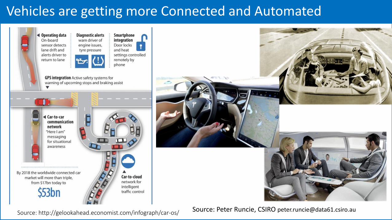
Transportation Infrastructure is going through a revolution
Source: USDOT
Source: USDOTSource: USDOT

Speed and Volume of Data is increasingVolume and speeds at which data today is generated, processed and stored will fundamentally alter the transport sector.
• The combination of low-cost sensors, low cost storage devices and new data mining and machine learning algorithms will provide significantly more detailed representations of reality.
• Sensors, data storage and communication capacity in automated and connected vehicles will provide enhanced safety.
Accuracy of data will be significantly improved by Mobile sensing technologies
• Precisely locate and track people within precision of a few inches in both outdoor and indoor environments.
• Similar technologies can be built into vehicles, enabling precise and persistent tracking.
Source: http://www.slideshare.net/AditiTechnologies/how-internet-of-things-iot-is-reshaping-the-automotive-sector-infographic

Intelligent Transportation Services
Source: Gayrard, Thalessgroup.com

Focus on
Communication (DSRC)
Intelligent Data Analytics
Intelligent Signal Control
Security and Privacy
Mixed Mode Traffic
I-Street: UF Smart Campus: Five year $10 million project

Our Research on Transportation Applications: Sample Projects
Multidisciplinary Collaborations between Computer Science and Transportation Engineers
Optimizing for a Transportation GridOptimizing for a Single Intersection
Truck Classification SPaT Data Analytics
Esri, HERE, DeLorme, MapmyIndia, © OpenStreetMap contributors, and the GIS user community
Mining Pedestrian Fatalities

Better overall Performance of Network by
➢ Minimizing average delay
➢ Minimizing Queue length
➢ Maximizing Network Capacity
While
➢ Ensuring Fairness
Optimizing Traffic for a Grid

Current State of the Art: Corridor Optimization
Source: Frost, Traffic Technology Today

P1 ( 7 – 9 AM) P4 ( 4 – 6 PM)
Network Optimization: Data driven partitioning

6 7 8 9 10 12 14 16 17 18 19 20 22 24-6
Monday P1 P2 P3 P4 P5 P6
Tuesday
Wednesday
Thursday
Friday
Saturday
Sunday
Network Optimization: Corridor Traffic Status
High Traffic MediumTraffic Low Traffic
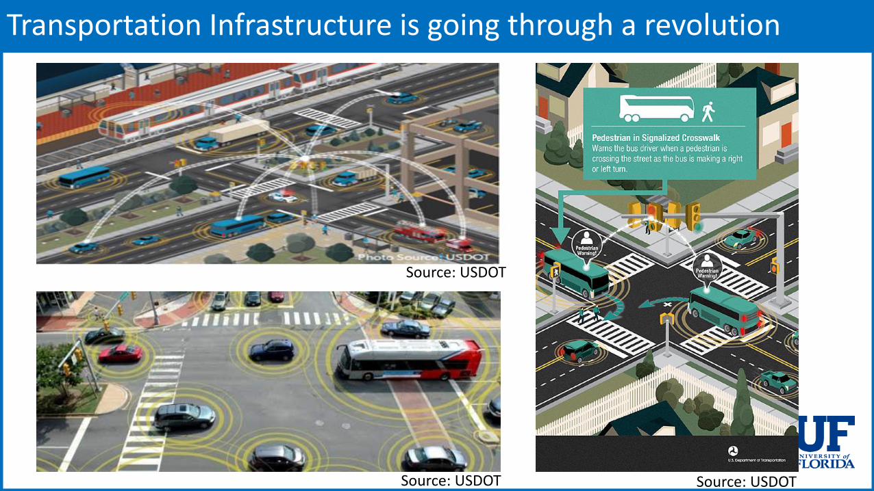
Truck and Commodity Classification Using Machine Learning
Machine Learning on Actuator Sensors and Video Images of Trucks passing on a highway
Text Recognition from Images

SPaT Data Analytics
SPaT/MAP message based applications (Time-to-Change Notification, Red Light Violation Warning, etc.)
Warnings (Forward Collision Warning, Emergency Brake Light Warning, Do Not Pass Warning)
TIMs - Curve Speed Warning, Speed Limit Changes/Updates, Work Zone Warning, and others (the ability these depend on which corridor is chosen for the instrumentation)

Bigdata: Predicting and preventing fatal crashes (FDOT D5)
Nearly 10000 crashes
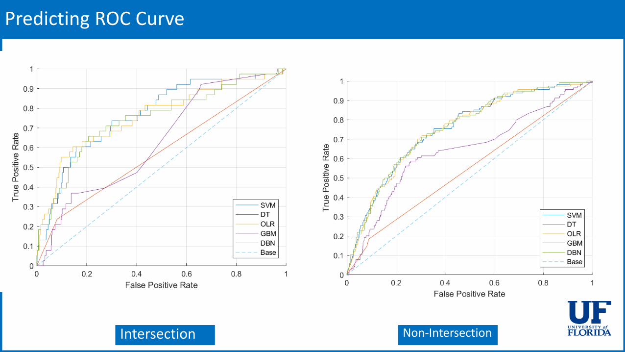
Predicting ROC Curve
Intersection Non-Intersection
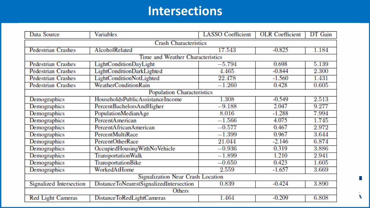
Intersections

Road Segments

Important Predictors
Predictor Description Coefficient
Means of transportation to work, other means
0.745
Percent of persons, American Indian and Alaska Native alone
0.390
Means of transportation to work, bicycle 0.362
Percent educational attainment, 25 years and over Bachelor’s degree only
0.173
Predictor Description Coefficient
Percent of persons, some other race alone 0.597
Means of transportation to work, walked 0.349
Partial sidewalk gap with sidewalk missing on one of the roadsides
0.266
Distance to the nearest transit stop 0.247
No sidewalk gap, with sidewalk missing on one roadside
0.209
Intersection Non-Intersection

Road Ranger Analytics
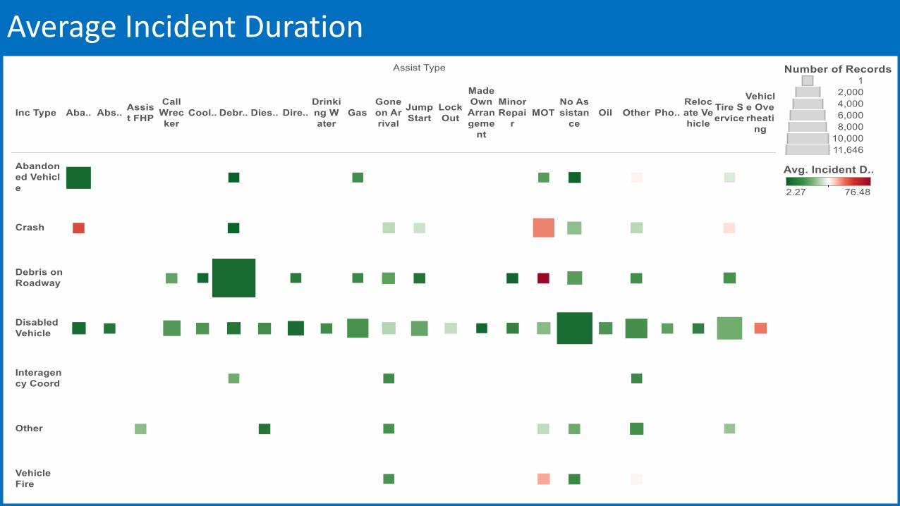
Average Incident Duration

Problem Description
Objective: Optimize the average delay by advising automated vehicles and controlling signal phase and timing (in real-time)
Sensing technologies• Dedicated Short Range
Communication
• Radar
• Camera, Lidar
Autonomous Vehicle Technology• Navigation and Localization algorithms
Optimization Algorithm• Vehicle Path Optimizer
• Signal Status Optimizer

Intelligent Intersection Control System

Sensor Fusion for Intelligent Intersection Control
Goal: Classify and track all traffic participants up to ~600 feet away from the intersection
Challenging Multisensor-Multitarget problem
• Occlusion is common in medium-heavy traffic
• Need to synchronize and associate sensor data in real-time
• Need accurate models of uncertainty in sensor measurements and vehicle dynamics

Sensor Fusion
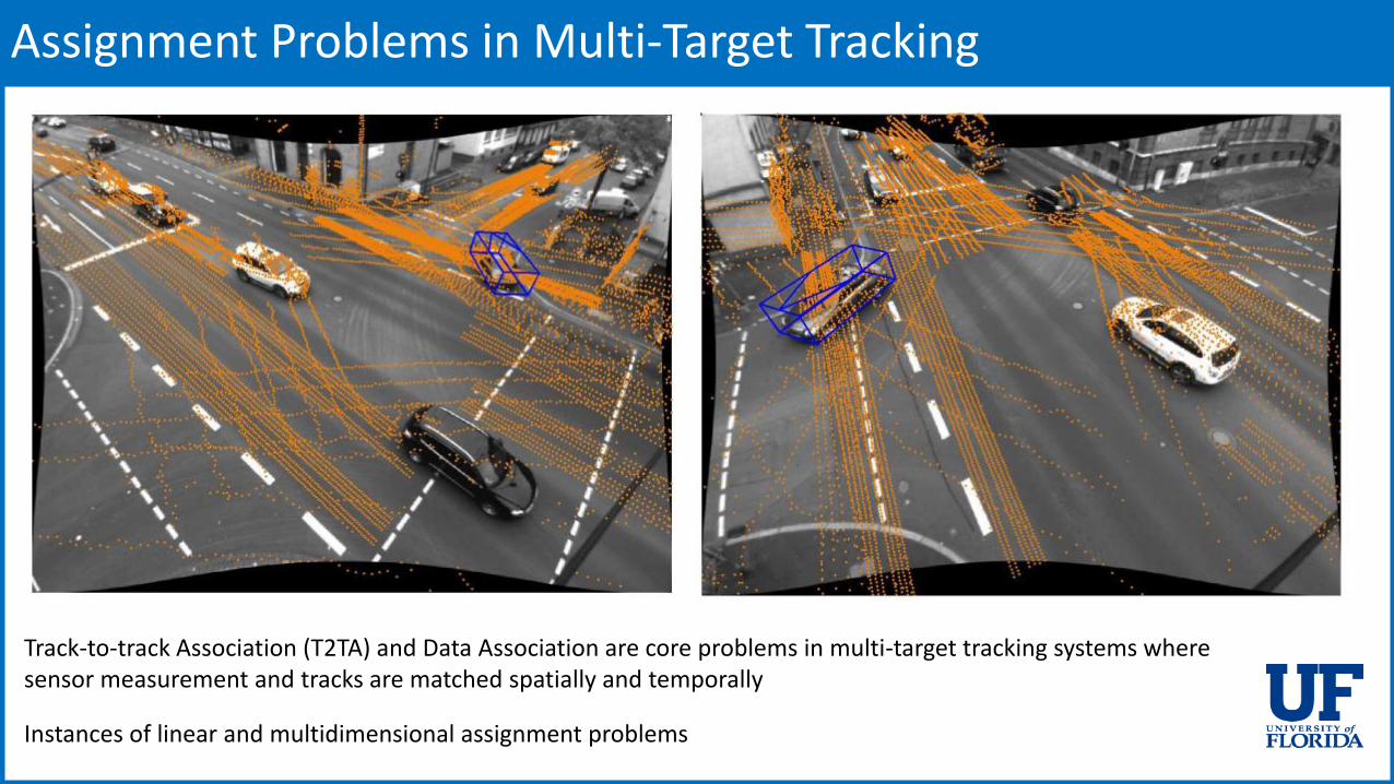
Assignment Problems in Multi-Target Tracking
Track-to-track Association (T2TA) and Data Association are core problems in multi-target tracking systems where sensor measurement and tracks are matched spatially and temporally
Instances of linear and multidimensional assignment problems

Signal Optimization Algorithm
Objective: Minimize the Average Travel Time Delay experienced at the intersection
Approach: Mathematical Programming
Description:• Automated Vehicles Shall receive a trajectory at
the time they enter the detection range
• The Trajectories Shall comply with signal status and have no conflict with other vehicles
• The joint decision on Trajectories and Signal Phase and Timing yields the minimum average travel time delay

Conclusions
Transportation is going through a IOT revolution
• New Sensors (Video, Lidar, Radar, ….)
• New Types of Vehicles
• New Communication Standards
• Cheap Computng and Storage Resources
Use of Data Analytics and Real-time Algorithms is becoming increasingly important
Significant challenges for Computer Scientists to develop real-time and offline changes
Need for multidisciplinary approaches for solving these problems
April 7, 2016 Sanjay Ranka
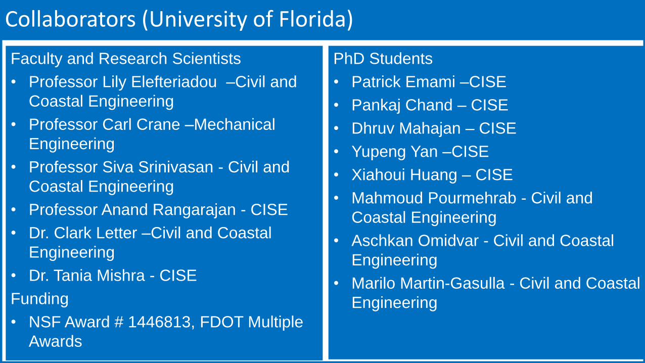
Collaborators (University of Florida)
Faculty and Research Scientists
• Professor Lily Elefteriadou –Civil and
Coastal Engineering
• Professor Carl Crane –Mechanical
Engineering
• Professor Siva Srinivasan - Civil and
Coastal Engineering
• Professor Anand Rangarajan - CISE
• Dr. Clark Letter –Civil and Coastal
Engineering
• Dr. Tania Mishra - CISE
Funding
• NSF Award # 1446813, FDOT Multiple
Awards
PhD Students
• Patrick Emami –CISE
• Pankaj Chand – CISE
• Dhruv Mahajan – CISE
• Yupeng Yan –CISE
• Xiahoui Huang – CISE
• Mahmoud Pourmehrab - Civil and
Coastal Engineering
• Aschkan Omidvar - Civil and Coastal
Engineering
• Marilo Martin-Gasulla - Civil and Coastal
Engineering
Top Related