


Languages
Pages
Legal

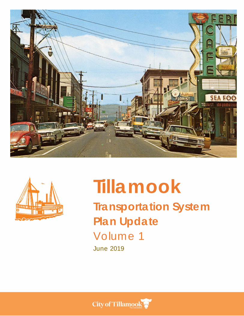
Tillamook Transportation System Plan Update Volume 1 June 2019
This page is intentionally left blank.
City of Tillamook
Transportation System Plan
Contents
Executive Summary ............................................................................................................... ES-1 ES.1 Study Area ........................................................................................................... ES-1 ES.2 Goals .................................................................................................................... ES-2 ES.3 Transportation System Projects ........................................................................ ES-2 ES.4 Funding ................................................................................................................ ES-8
Chapter 1: Introduction .............................................................................................................. 1 1.1 Purpose of the TSP ................................................................................................... 1 1.2 Policy Context ......................................................................................................... 1 1.3 Study Area ................................................................................................................ 3 1.4 Plan Process ............................................................................................................. 6 1.5 Public Involvement ................................................................................................. 7
Chapter 2: Goals and Policies ................................................................................................. 10 2.1 TSP Goals ................................................................................................................ 10 2.2 Policies .................................................................................................................... 11 2.3 Evaluation Criteria ................................................................................................ 16
Chapter 3: Transportation System Plan ................................................................................... 18 3.1 Functional Classification Plan ............................................................................. 19 3.2 Roadway System Plan .......................................................................................... 22 3.3 Pedestrian and Bicycle System Plan .................................................................. 34 3.4 Public Transportation System Plan ..................................................................... 58 3.5 Truck Freight System Plan ..................................................................................... 62 3.6 Rail Plan .................................................................................................................. 65 3.7 Aviation Plan .......................................................................................................... 65 3.8 Marine Transportation .......................................................................................... 66 3.9 Pipelines .................................................................................................................. 66
Chapter 4: Implementation ..................................................................................................... 62 4.1 Funding Sources .................................................................................................... 62 4.2 Funding Gap and Recommendations .............................................................. 65
City of Tillamook Transportation System Plan
Appendices
Appendix A: Public Involvement Plan
Appendix B: Background Plans and Policies Review
Appendix C: Regulatory Review
Appendix D: Goals, Objectives, and Evaluation Criteria
Appendix E: Existing Conditions
Appendix F: Future Conditions
Appendix G: Future Needs
Appendix H: Solutions Evaluation
Appendix I: Finance Program
Appendix J: Transportation Standards
Appendix K: US-101 Pedestrian Crossings Study
City of Tillamook Transportation System Plan
Acknowledgements
Project Advisory Committee Kaylan Sisco, Tillamook County Family YMCA Dave Wells, Tillamook County Family YMCA Debbi Reeves, Tillamook URA Doug Pilant, Tillamook Transit Jan Stewart, Planning Commission Tamra Jacobs, Planning Commission Jay Marugg, Tillamook School District #9 Chief Rick Adams, Tillamook Fire Alene Allen, Resident Michelle Jenck, Jenck Farms Wayne Alvarez, Tillamook Regional Medical Center Sierra Lauder, Tillamook Chamber of Commerce Nan Devlin, Visit Tillamook Coast Erin Skaar, Community Action Resources Enterprises (CARE) Todd Bouchard, OBB Partners V, LLC Bobby Poppe, City Sanitary Marc Hinz, Kayak Tillamook Larry and Cindy Oswald, Residents Michele Bradley, Port of Tillamook Bay Ross Tomlin, Tillamook Bay Community College Harry Hewitt, Churches Claudine Rehn, Tillamook Estuary Partnership Patrick Wingard, DLCD Bryan Pohl, Tillamook County Community Development KC Fagan, Tillamook People’s Utility District (TPUD) Dave Mattison, Resident Michael Barberry, RARE Program James Amen, Tillamook PUD Brian Vosburgh, Tillamook PUD Laura Swanson, Tillamook Co Pioneer Editor Lisa Phipps, DLCD
Project Staff Paul Wyntergreen, City Manager Liane Welch, City Engineer Tim Lyda, City Public Works Director Ken Shonkwiler, Oregon Department of Transportation (ODOT), Project Manager Kristin Hull, Jacobs Engineering Ryan Farncomb, Jacobs Engineering Eduardo Montejo, Jacobs Engineering Jason Nolin, Jacobs Engineering Garth Appanaitis, P.E., DKS Darci Rudzinski, APG Jamin Kimmel, APG
The contents of this document do not necessarily reflect views or policies of the State of Oregon.
City of Tillamook Transportation System Plan
Acronyms and Abbreviations
ADA Americans with Disabilities Act
LOS Level of Service (traffic engineering term)
MPO Metropolitan Planning Organization
ODOT Oregon Department of Transportation
OHP Oregon Highway Plan
OTP Oregon Transportation Plan
PAC Project Advisory Committee
PMT Project Management Team
SRTS Safe Routes to School
STIP Statewide Transportation Improvement Program
TBCC Tillamook Bay Community College
TCTD Tillamook County Transportation District
TPR Transportation Planning Rule
TSP Transportation System Plan
UGB Urban Growth Boundary
V/C Volume/Capacity (traffic engineering term)
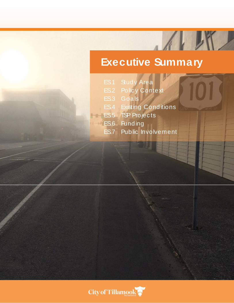
ES.1 Study Area ES.2 Policy Context ES.3 Goals ES.4 Existing Conditions ES.5 TSP Projects ES.6 Funding ES.7 Public Involvement
Executive Summary

ES-1
Executive Summary The safe and efficient movement of people and goods is vital to a healthy city. The Tillamook Transportation System Plan (TSP) is the City’s long-range plan to guide investment in the City’s transportation system over the next 20 years. The executive summary provides an overview of the Tillamook TSP, including plan objectives, policy context, and projects. The Tillamook Transportation System Plan (TSP) sets a 20+ year vision for the City’s transportation
system for the horizon year of 2040 based on current needs, predicted growth, and public input. The
plan examines current (2018) and expected future transportation conditions in the City and establishes a
combination of projects, policies, and programs to address them. This plan is a periodic update to the
2003 TSP; since then, Tillamook has experienced an increase in population and employment, placing
additional demand on the City’s transportation facilities and services. The 2016 Hoquarton Waterfront
Plan will change circulation patterns in the northwest quadrant of downtown. The US 101/OR 6 Project,
currently in construction, addresses a key safety and congestion issue. New regional projects, like the
Salmonberry Trail, will change how people travel to and through Tillamook.
The TSP establishes high‐level goals for the transportation system and provides an analysis of current
(2018) and future transportation needs. It also includes near, medium, and long‐term policies, projects,
and programs to address those needs, as well as a funding plan and investment strategy to implement
them. All modes are considered, with special attention to making the system safer and better‐connected
to improve the quality of life in the City. The plan considers how the City will grow and addresses the
needs of residents, businesses, and visitors alike.
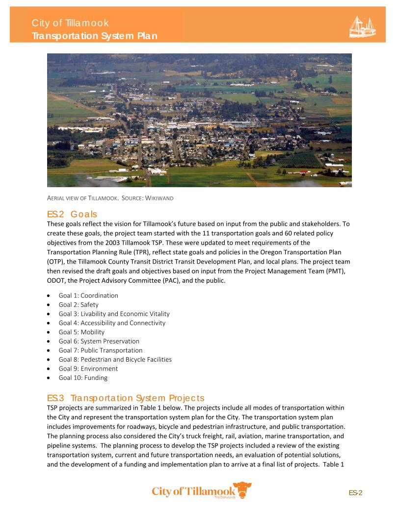
ES.1 Study Area The City of Tillamook is located in western Tillamook County, on the southeast end of Tillamook Bay and
west of the Tillamook State Forest. The City is about 60 miles west of Portland and less than 10 miles
from the Oregon coast. Tillamook is the largest City in Tillamook County, with a population of about
5,000 as of 2018 and is the county seat. Dairy farming, timber, fishing, and tourism are the major
industries in Tillamook.
The Tillamook TSP study area includes the Tillamook Urban Growth Boundary (UGB) and all areas within
the City limits.
The City’s transportation network includes state, county, and City roadways, the Port of Tillamook Bay
railroad, bicycle facilities, sidewalks, trails, and the Tillamook Airport. The City is bisected east‐west by
US‐101, a state highway connecting Tillamook to the communities of Garibaldi and Bay City to the north
and Lincoln City to the south. US‐101 is the Main Avenue/Pacific Avenue couplet in downtown
Tillamook. The City is bisected north‐south by OR‐6, which splits into 1st Street and Netarts
Highway/OR‐131 at Miller Avenue. OR‐6 connects Tillamook to US‐26 and Portland to the east.
ES-2
City of Tillamook Transportation System Plan
AERIAL VIEW OF TILLAMOOK. SOURCE: WIKIWAND
ES.2 Goals These goals reflect the vision for Tillamook’s future based on input from the public and stakeholders. To
create these goals, the project team started with the 11 transportation goals and 60 related policy
objectives from the 2003 Tillamook TSP. These were updated to meet requirements of the
Transportation Planning Rule (TPR), reflect state goals and policies in the Oregon Transportation Plan
(OTP), the Tillamook County Transit District Transit Development Plan, and local plans. The project team
then revised the draft goals and objectives based on input from the Project Management Team (PMT),
ODOT, the Project Advisory Committee (PAC), and the public.
Goal 1: Coordination
Goal 2: Safety
Goal 3: Livability and Economic Vitality
Goal 4: Accessibility and Connectivity
Goal 5: Mobility
Goal 6: System Preservation
Goal 7: Public Transportation
Goal 8: Pedestrian and Bicycle Facilities
Goal 9: Environment
Goal 10: Funding
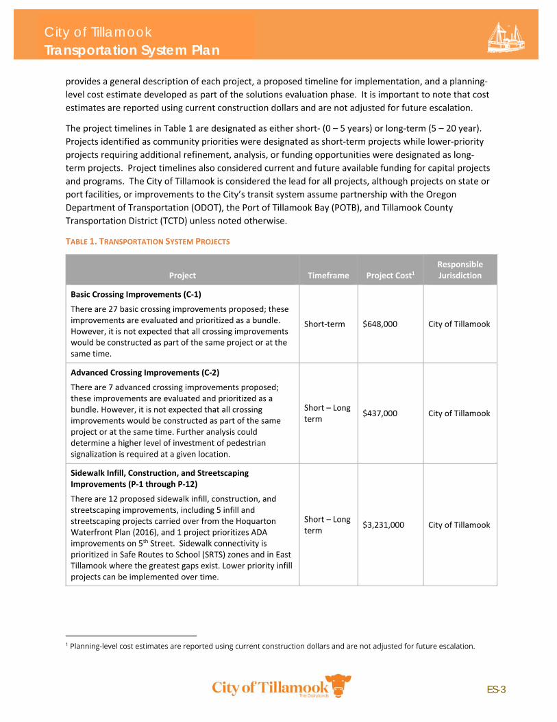
ES.3 Transportation System Projects TSP projects are summarized in Table 1 below. The projects include all modes of transportation within
the City and represent the transportation system plan for the City. The transportation system plan
includes improvements for roadways, bicycle and pedestrian infrastructure, and public transportation.
The planning process also considered the City’s truck freight, rail, aviation, marine transportation, and
pipeline systems. The planning process to develop the TSP projects included a review of the existing
transportation system, current and future transportation needs, an evaluation of potential solutions,
and the development of a funding and implementation plan to arrive at a final list of projects. Table 1
ES-3
City of Tillamook Transportation System Plan
provides a general description of each project, a proposed timeline for implementation, and a planning‐
level cost estimate developed as part of the solutions evaluation phase. It is important to note that cost
estimates are reported using current construction dollars and are not adjusted for future escalation.
The project timelines in Table 1 are designated as either short‐ (0 – 5 years) or long‐term (5 – 20 year).
Projects identified as community priorities were designated as short‐term projects while lower‐priority
projects requiring additional refinement, analysis, or funding opportunities were designated as long‐
term projects. Project timelines also considered current and future available funding for capital projects
and programs. The City of Tillamook is considered the lead for all projects, although projects on state or
port facilities, or improvements to the City’s transit system assume partnership with the Oregon
Department of Transportation (ODOT), the Port of Tillamook Bay (POTB), and Tillamook County
Transportation District (TCTD) unless noted otherwise.
TABLE 1. TRANSPORTATION SYSTEM PROJECTS
Project Timeframe Project Cost1 Responsible Jurisdiction
Basic Crossing Improvements (C‐1)
There are 27 basic crossing improvements proposed; these improvements are evaluated and prioritized as a bundle. However, it is not expected that all crossing improvements would be constructed as part of the same project or at the same time.
Short‐term $648,000 City of Tillamook
Advanced Crossing Improvements (C‐2)
There are 7 advanced crossing improvements proposed; these improvements are evaluated and prioritized as a bundle. However, it is not expected that all crossing improvements would be constructed as part of the same project or at the same time. Further analysis could determine a higher level of investment of pedestrian signalization is required at a given location.
Short – Long term
$437,000 City of Tillamook
Sidewalk Infill, Construction, and Streetscaping Improvements (P‐1 through P‐12)
There are 12 proposed sidewalk infill, construction, and streetscaping improvements, including 5 infill and streetscaping projects carried over from the Hoquarton Waterfront Plan (2016), and 1 project prioritizes ADA improvements on 5th Street. Sidewalk connectivity is prioritized in Safe Routes to School (SRTS) zones and in East Tillamook where the greatest gaps exist. Lower priority infill projects can be implemented over time.
Short – Long term
$3,231,000 City of Tillamook
1 Planning-level cost estimates are reported using current construction dollars and are not adjusted for future escalation.
ES-4
City of Tillamook Transportation System Plan
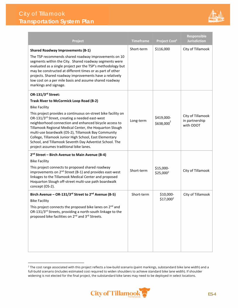
Project Timeframe Project Cost1 Responsible Jurisdiction
Shared Roadway Improvements (B‐1)
The TSP recommends shared roadway improvements on 10 segments within the City. Shared roadway segments were evaluated as a single project per the TSP’s methodology but may be constructed at different times or as part of other projects. Shared roadway improvements have a relatively low cost on a per mile basis and assume shared roadway markings and signage.
Short‐term $116,000 City of Tillamook
OR‐131/3rd Street:
Trask River to McCormick Loop Road (B‐2)
Bike Facility
This project provides a continuous on‐street bike facility on OR‐131/3rd Street, creating a needed east‐west neighborhood connection and enhanced bicycle access to Tillamook Regional Medical Center, the Hoquarton Slough multi‐use boardwalk (OS‐2), Tillamook Bay Community College, Tillamook Junior High School, East Elementary School, and Tillamook Seventh Day Adventist School. The project assumes traditional bike lanes.
Long‐term $419,000‐
$638,0002
City of Tillamook in partnership with ODOT
2nd Street – Birch Avenue to Main Avenue (B‐4)
Bike Facility
This project connects to proposed shared roadway improvements on 2nd Street (B‐1) and provides east‐west linkages to the Tillamook Medical Center and proposed Hoquarton Slough off‐street multi‐use path boardwalk concept (OS‐2).
Short‐term $15,000‐$25,0002
City of Tillamook
Birch Avenue – OR‐131/3rd Street to 2nd Avenue (B‐5)
Bike Facility
This project connects the proposed bike lanes on 2nd and OR‐131/3rd Streets, providing a north‐south linkage to the proposed bike facilities on 2nd and 3rd Streets.
Short‐term $10,000‐$17,0002
City of Tillamook
2 The cost range associated with this project reflects a low-build scenario (paint markings, substandard bike lane width) and a full-build scenario (includes estimated cost required to widen shoulders to achieve standard bike lane width). If shoulder widening is not elected for the final project, the substandard bike lanes may need to be deployed in select locations.
ES-5
City of Tillamook Transportation System Plan
Project Timeframe Project Cost1 Responsible Jurisdiction
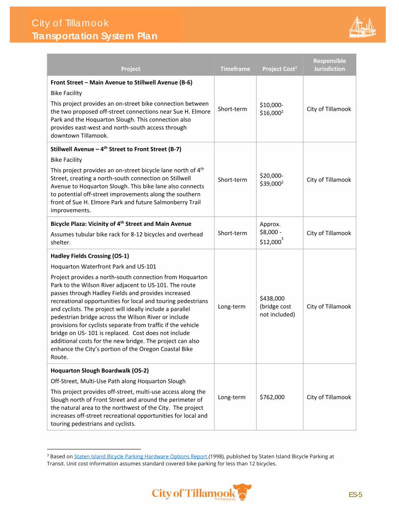
Front Street – Main Avenue to Stillwell Avenue (B‐6)
Bike Facility
This project provides an on‐street bike connection between the two proposed off‐street connections near Sue H. Elmore Park and the Hoquarton Slough. This connection also provides east‐west and north‐south access through downtown Tillamook.
Short‐term $10,000‐$16,0002
City of Tillamook
Stillwell Avenue – 4th Street to Front Street (B‐7)
Bike Facility
This project provides an on‐street bicycle lane north of 4th Street, creating a north‐south connection on Stillwell Avenue to Hoquarton Slough. This bike lane also connects to potential off‐street improvements along the southern front of Sue H. Elmore Park and future Salmonberry Trail improvements.
Short‐term $20,000‐$39,0002
City of Tillamook
Bicycle Plaza: Vicinity of 4th Street and Main Avenue
Assumes tubular bike rack for 8‐12 bicycles and overhead shelter.
Short‐term
Approx. $8,000 ‐
$12,0003
City of Tillamook
Hadley Fields Crossing (OS‐1)
Hoquarton Waterfront Park and US‐101
Project provides a north‐south connection from Hoquarton Park to the Wilson River adjacent to US‐101. The route passes through Hadley Fields and provides increased recreational opportunities for local and touring pedestrians and cyclists. The project will ideally include a parallel pedestrian bridge across the Wilson River or include provisions for cyclists separate from traffic if the vehicle bridge on US‐ 101 is replaced. Cost does not include additional costs for the new bridge. The project can also enhance the City’s portion of the Oregon Coastal Bike Route.
Long‐term $438,000 (bridge cost not included)
City of Tillamook
Hoquarton Slough Boardwalk (OS‐2)
Off‐Street, Multi‐Use Path along Hoquarton Slough
This project provides off‐street, multi‐use access along the Slough north of Front Street and around the perimeter of the natural area to the northwest of the City. The project increases off‐street recreational opportunities for local and touring pedestrians and cyclists.
Long‐term $762,000 City of Tillamook
3 Based on Staten Island Bicycle Parking Hardware Options Report (1998), published by Staten Island Bicycle Parking at Transit. Unit cost information assumes standard covered bike parking for less than 12 bicycles.
ES-6
City of Tillamook Transportation System Plan
Project Timeframe Project Cost1 Responsible Jurisdiction
Tillamook Junior High to 12th Street (OS‐3)
Off‐street pedestrian connection from Alder Avenue to 12th Street through wetland area to the south. Includes potential Sensitive Wetland Area mitigation costs and a pedestrian bridge to minimize environmental impacts.
Long‐term $753,000 City of Tillamook
Twelfth Trail – 12th Street Off‐Street Connection (OS‐4)
Tillamook High School to Pacific Avenue
This project proposes an off‐street extension of 12th Street through wetland area to connect Miller Avenue to US‐101 NB Pacific Avenue. Includes potential Sensitive Wetland Area mitigation costs and a pedestrian ramp to minimize environmental impacts.
Long‐term $287,000 City of Tillamook
Salmonberry Trail Improvements (OS‐5)
This project proposes an enhanced off‐street pedestrian/bicycle link along 3rd Street, Miller Avenue, and Pacific Avenue to the planned Salmonberry Trail. Project assumes no wetland impacts or right‐of‐way needed. The project lead is the Port of Tillamook Bay in coordination with the City of Tillamook.
Short‐term $629,0004
City of Tillamook in partnership with Port of Tillamook Bay
3rd Street and Evergreen Drive Intersection Improvement (R‐1) – Alternative 3 Two‐Way Left Turn Lane
This alternative provides the greatest mobility benefit at the lowest cost.
Long‐term $307,000 City of Tillamook
3rd Street and Marolf Loop Road Intersection Improvement (R‐2) – Alternative 3 Two‐Way Left Turn Lane
This alternative provides the greatest mobility benefit at the lowest cost.
Long‐term $289,000
City of Tillamook in partnership with Tillamook County
Hampton Lumber Company Connectivity (R‐4)
Consider connectivity alternatives as required by future development needs. Potential connections and street upgrades include 5th and 8th Streets from Miller Avenue to Evergreen Drive. Subject to further study, analysis, and engagement with site stakeholders.
Long‐term TBD City of Tillamook
US‐101/ Hadley Road Access Control (R‐7)
Consolidate driveways near intersection of US‐101 and Hadley Road
Long‐term $85,0005 City of Tillamook in partnership with ODOT
4 The cost estimate for Salmonberry Trail Improvements (OS-5) was developed by City of Tillamook staff in 2018.
5 Indexed for construction cost inflation (70% increase) for cost prepared in 2003 TSP.
ES-7
City of Tillamook Transportation System Plan
Project Timeframe Project Cost1 Responsible Jurisdiction
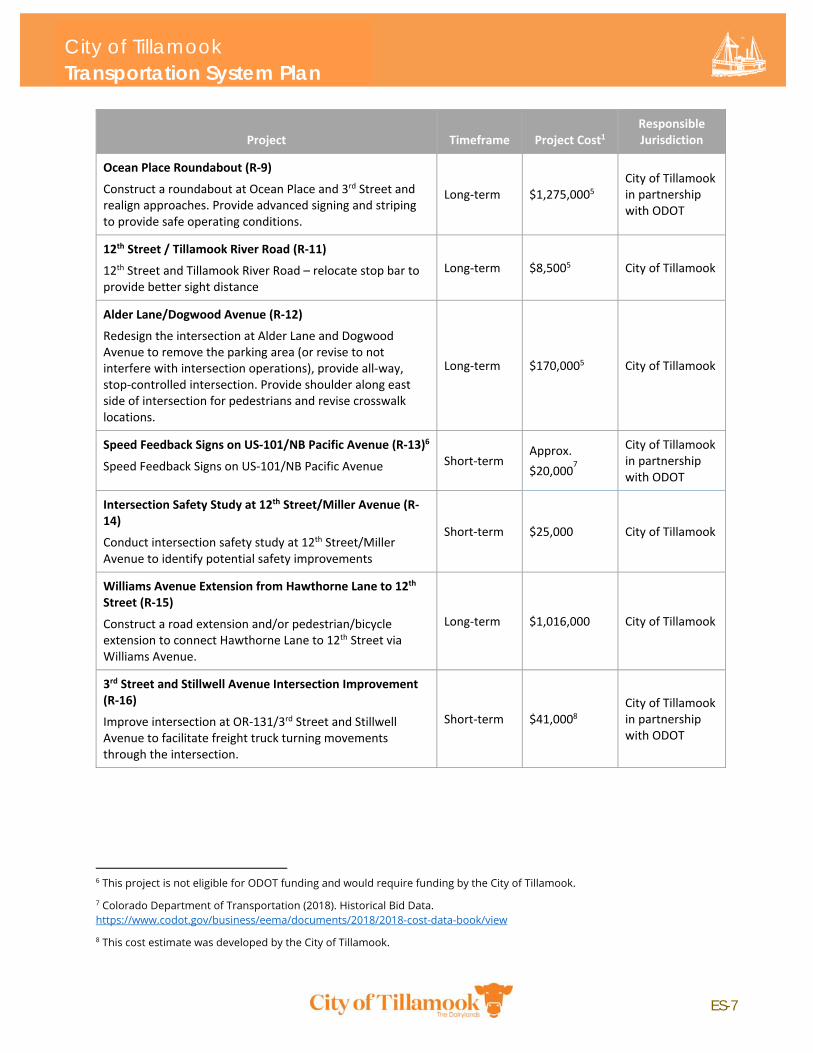
Ocean Place Roundabout (R‐9)
Construct a roundabout at Ocean Place and 3rd Street and realign approaches. Provide advanced signing and striping to provide safe operating conditions.
Long‐term $1,275,0005 City of Tillamook in partnership with ODOT
12th Street / Tillamook River Road (R‐11)
12th Street and Tillamook River Road – relocate stop bar to provide better sight distance
Long‐term $8,5005 City of Tillamook
Alder Lane/Dogwood Avenue (R‐12)
Redesign the intersection at Alder Lane and Dogwood Avenue to remove the parking area (or revise to not interfere with intersection operations), provide all‐way, stop‐controlled intersection. Provide shoulder along east side of intersection for pedestrians and revise crosswalk locations.
Long‐term $170,0005 City of Tillamook
Speed Feedback Signs on US‐101/NB Pacific Avenue (R‐13)6
Speed Feedback Signs on US‐101/NB Pacific Avenue Short‐term Approx.
$20,0007
City of Tillamook in partnership with ODOT
Intersection Safety Study at 12th Street/Miller Avenue (R‐14)
Conduct intersection safety study at 12th Street/Miller Avenue to identify potential safety improvements
Short‐term $25,000 City of Tillamook
Williams Avenue Extension from Hawthorne Lane to 12th Street (R‐15)
Construct a road extension and/or pedestrian/bicycle extension to connect Hawthorne Lane to 12th Street via Williams Avenue.
Long‐term $1,016,000 City of Tillamook
3rd Street and Stillwell Avenue Intersection Improvement (R‐16)
Improve intersection at OR‐131/3rd Street and Stillwell Avenue to facilitate freight truck turning movements through the intersection.
Short‐term $41,0008 City of Tillamook in partnership with ODOT
6 This project is not eligible for ODOT funding and would require funding by the City of Tillamook.
7 Colorado Department of Transportation (2018). Historical Bid Data. https://www.codot.gov/business/eema/documents/2018/2018-cost-data-book/view
8 This cost estimate was developed by the City of Tillamook.
ES-8
City of Tillamook Transportation System Plan
ES.4 Funding The total cost of TSP projects is approximately $11,152,000.9 Of this amount, $8,570,000 of projects are
assumed to eligible for federal or state grant funding programs.10 Additionally, most of the bicycle and
pedestrian improvement projects, or $7,915,000, are likely eligible for Safe Routes to School program
funds.11 Approximately $2,582,000 of projects are not likely eligible for federal or state grant funding
and would require local funding to complete. See Chapter 4 of the TSP to review the City’s approximate
local contribution needed to fund state or federally‐funded projects; the exact funding sources and
match requirements are subject to individual project funding and financing decisions during
implementation of the TSP.
9 Some project costs in Appendix H: Solutions Evaluation are presented as a range; this total cost uses the mid-range where a range of costs was given.
10 This includes projects on state highways (US 101 and OR 6) and off-street path projects that are likely to become part of the future Salmonberry Trail project. Other projects on federally functionally classified roadways (e.g., 3rd Street) would potentially be eligible for state or federal funding programs, but it is less likely that they would be funded.
11 Draft SRTS rules for House Bill 2017 require a 40% local match as of this writing. Previous match requirement was 12% when the SRTS program was primarily federally-funded
ES-9
1.1 Purpose of the TSP 1.2 Policy Context 1.3 Study Area 1.4 Plan Process 1.5 Public Involvement
Chapter 1: Introduction
1
Chapter 1: Introduction This section introduces the plan and establishes the purpose, policy context, and planning process under which the TSP Update was developed. The introduction includes a generalized review of the study area and key community characteristics, including historical growth and key economic activities and centers. This section also summarizes the public involvement activities that supported plan development.
1.1 Purpose of the TSP The Tillamook Transportation System Plan (TSP) sets a 20+ year vision for the City’s transportation
system for the horizon year of 2040. The plan examines the current (2018) and expected future
transportation needs in the City and establishes a combination of projects, policies, and programs to
meet them. This TSP Update considers the previous 2003 TSP and was informed by a public involvement
process to ensure that plan outcomes align with the values and needs of all system users, including
residents, businesses, freight, employees, and visitors. The plan considers system improvements for all
modes whether travelling by foot, bike, car, bus, truck, train, or airplane. Existing land use plans,
policies, and regulations that affect the transportation system are reflected in the document. The plan
includes policies, a list of short‐ and long‐term improvement projects, and an implementation plan for
how and when to finance future projects.
1.2 Policy Context TSPs are developed per Oregon’s Transportation Planning Rule (OAR 660‐012), which implements
Statewide Planning Goal 12 (Transportation), which is intended to promote the development of safe,
convenient, and economic transportation systems that are designed to maximize the benefit of
investment and to reduce reliance on the automobile.
This plan is an update of the 2003 Tillamook Transportation System Plan. Projects and other elements
from the 2003 TSP were reviewed for inclusion in this update. The TSP is the transportation element of
the Tillamook Comprehensive Plan. Adopted in 2012 and updated in 2016, the Comprehensive Plan
provides a framework to guide the future growth and development of the City. This TSP is informed by
relevant goals, objectives and policies found in the Comprehensive Plan. This plan was built upon prior
planning efforts and developed to be consistent with plans, policies, goals, and other regulations at the
state, regional, and local level. Relevant plans are outlined in Appendix B: Background Plans and Policy
Review.
City of Tillamook Transportation System Plan
2
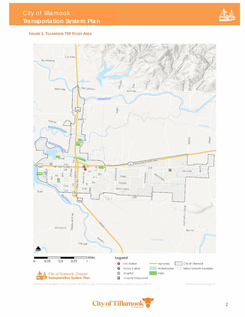
FIGURE 1. TILLAMOOK TSP STUDY AREA
City of Tillamook Transportation System Plan
3
1.3 Study Area The City of Tillamook is located in western Tillamook County, on the southeast end of Tillamook Bay, and
west of the Tillamook State Forest. The City is about 60 miles west of Portland and less than 10 miles
from the Oregon coast. Tillamook is the largest City in Tillamook County with a population of about
5,000 as of 2015 and is the county seat. Dairy farming, timber, fishing, and tourism are the major
industries in Tillamook. The Tillamook TSP study area includes the Tillamook Urban Growth Boundary
(UGB) and all areas within the City limits.
The City’s transportation network includes state, county, and City roadways, the Port of Tillamook Bay
railroad, bicycle facilities, sidewalks, trails, and the Tillamook Airport. The City is bisected east‐west by
US‐101, a state highway connecting Tillamook to the communities of Garibaldi and Bay City to the north
and Lincoln City to the south. US‐101 is the Main Avenue/Pacific Avenue couplet in downtown
Tillamook. The City is bisected north‐south by OR‐6, which splits into 1st Street and Netarts
Highway/OR‐131 at Miller Avenue. OR‐6 connects Tillamook to US‐26 and Portland to the east (Figure 1)
Land Use Land use patterns and major activity centers influence the overall movement of people and goods
throughout the transportation system and the origin/destination points for trips. Most of the land in the
City is zoned residential and served by two lane local roads. Much of the City’s multifamily residential
development is located immediately adjacent to OR‐6/OR‐131 (1st and 3rd Streets). Commercial
development is primarily located in downtown Tillamook and north along US‐101, which has numerous
shops, restaurants, and community destinations. Vacant land within the City is predominately zoned
Highway Commercial and is located to the north of the City, along US‐101 and along OR‐6/OR‐131 in the
east.
The Hampton Lumber Company, Tillamook Creamery, and Port of Tillamook Bay are significant
community destinations and trip generators. The Hampton Lumber Company is a major industrial site
that bifurcates the City into east and west sections with transportation connectivity to the north (on
OR‐131/3rd Street) and south (on 12th Street). The Tillamook Creamery and the Port of Tillamook Bay are
major industrial sites outside of the City. The Tillamook Creamery is located north of the City and UGB
and the Port of Tillamook Bay is located approximately three miles south of town. There are other
industrial zones north and south of the Wilson River, as well as smaller dispersed industrial sites
throughout the City, served primarily by OR‐6/OR‐131.
Tillamook is home to several parks, trails, and open recreational areas. The City has four main active
parks. It also encompasses sensitive environmental features, including wetlands, an estuary, floodplains,
agricultural lands, and undeveloped open space. Multiple rivers flow within and adjacent to the study
area. The Tillamook Comprehensive Plan goals and objectives for natural resources and wetlands (2012)
recognizes the importance of these natural resources and supports their preservation. Many of the
wetlands in the area have been identified as “significant natural resources,” requiring a high level of
function in water quality, hydrologic control, fish habitat, or wildlife habitat as defined in the Oregon
Freshwater Wetland Assessment Methodology. The City has also adopted a 50‐foot riparian setback
adjacent to significant riparian resources based on the Economic, Social, Environmental, and Energy
Decision Process (ESEE). For the purposes of this plan, all waterways within the UGB (including the Trask
and Wilson Rivers) are considered significant riparian resources.
City of Tillamook Transportation System Plan
4
Special Transportation Area The segment of US‐101 from 1st Street to 12th Street (near the southern UGB limits) is designated a
special transportation area (STA). An STA is an area of compact development located on a state highway
where the need for appropriate local access outweighs the considerations of highway mobility. STAs
have specific objectives for access management, automobiles, pedestrian and bicycle accommodation,
transit amenities, and development. This may result in lower speeds, narrower lane widths, and wider
sidewalks than is otherwise required for the state highway outside of the STA.
Future Growth Tillamook’s population has been relatively stable. Between 2010 and 2015, the City grew by 136 people.
As of 2018, the population within the Tillamook Urban Growth Boundary (UGB) is 5,569 based on
Portland State University Population Research Center estimates (the UGB is larger than the City limits).
The population of Tillamook is expected to grow by about 16 percent by 2040, yielding a population of
approximately 6,500 people. This increase in population is expected to be predominately in the
southeast corner of the City. There are few projections for local employment growth. Future estimates
assume employment to grow proportionally with population growth, from approximately 4,100 jobs in
2017 to 4,800 jobs in 2040. More of these jobs are expected to be along US‐101 in the northern portion
of the City.
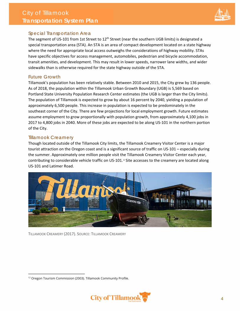
Tillamook Creamery Though located outside of the Tillamook City limits, the Tillamook Creamery Visitor Center is a major
tourist attraction on the Oregon coast and is a significant source of traffic on US‐101 – especially during
the summer. Approximately one million people visit the Tillamook Creamery Visitor Center each year,
contributing to considerable vehicle traffic on US‐101.12 Site accesses to the creamery are located along
US‐101 and Latimer Road.
TILLAMOOK CREAMERY (2017). SOURCE: TILLAMOOK CREAMERY
12 Oregon Tourism Commission (2003). Tillamook Community Profile.
City of Tillamook Transportation System Plan
5
Downtown Tillamook The City’s commercial and cultural hub is downtown Tillamook, offering numerous options for shopping,
dining, and recreation. The greatest concentration of boutique storefronts, specialty services, and
eateries are located along the US‐101 couplet (SB Main and NB Pacific Avenues). Other destinations in
the downtown vicinity include:
Tillamook County Library
Tillamook County Courthouse
Tillamook City Hall
Tillamook County Pioneer Museum
Tillamook Coliseum Theater
Pelican Brewery and Taproom
Safeway
Tillamook Town Square Transit and Visitor Center
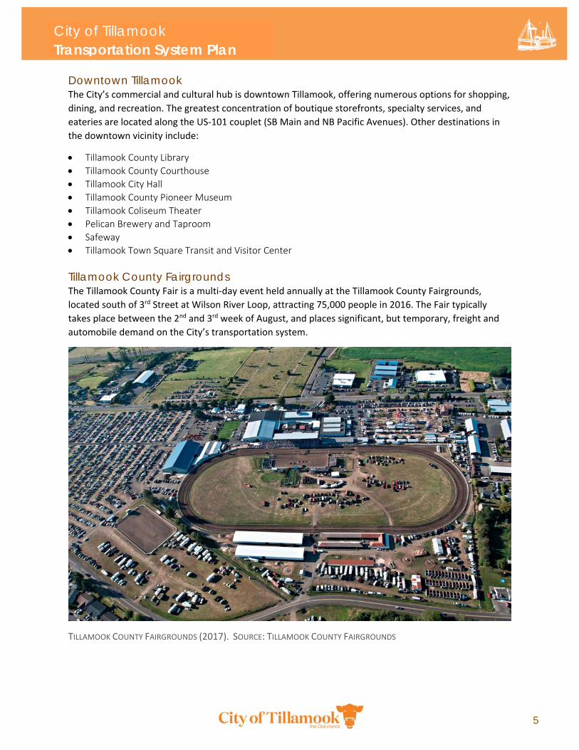
Tillamook County Fairgrounds The Tillamook County Fair is a multi‐day event held annually at the Tillamook County Fairgrounds,
located south of 3rd Street at Wilson River Loop, attracting 75,000 people in 2016. The Fair typically
takes place between the 2nd and 3rd week of August, and places significant, but temporary, freight and
automobile demand on the City’s transportation system.
TILLAMOOK COUNTY FAIRGROUNDS (2017). SOURCE: TILLAMOOK COUNTY FAIRGROUNDS
City of Tillamook Transportation System Plan
6
Port of Tillamook Bay Employment Area The Port of Tillamook Bay employment area is a major employment center in Tillamook County,
comprising more than 1,600 acres of industrial‐zoned land. The Port operates several commercial and
industrial assets, including the Tillamook Municipal Airport, an Airport Business Park, and the Air
Museum. Outside of the UGB, the Port also owns a 200‐acre industrial park that hosts multiple
manufacturing and development operations, including Stimson Lumber Mill, CHS Feed Mill, and Hallco
Industries. Near Space Corporation, a commercial provider of high‐altitude, near‐space platforms and
flight services for government, academic, and commercial customers, employs many within the Port
employment area. Most of the Port’s commercial and industrial lands are accessible via US‐101.
Tillamook Bay Community College Tillamook Bay Community College (TBCC) was founded in 1981 and enrolls about 3,500 students. The
TBCC main campus is located on the corner of 3rd Street and Marolf Loop Road. In spring 2017, the
Partners for Rural Innovation (PRI) Center was opened to support innovation, job readiness, and
economic development in the community. The PRI Center houses several community organizations and
resources, including an Oregon State University Extension Service, the TBCC Agriculture and Natural
Resource degree program, the Tillamook Economic Development Council, the Tillamook Small Business
Development Center, and the Visit Tillamook Coast tourism team. The TBCC area is likely to generate
consistent trips throughout the day with additional peak AM and PM periods.
Schools Tillamook currently has four public schools, Tillamook High School, Liberty Elementary School, Tillamook
Junior High, and East Elementary School, as well as two private schools, Tillamook Adventist School and
Pacific Christian School. These schools are likely to generate peak hour trips in the mornings and
afternoons.
1.4 Plan Process The Tillamook TSP process began in late 2016 and finished in late 2018. The process started with
convening a project management team (PMT) consisting of key City, ODOT, and consultant staff. The
PMT guided the process throughout the project. A Project Advisory Committee (PAC) composed of
33 stakeholders was created to guide the project team on goals, transportation issues, potential
solutions, and the final TSP Update. The PAC met four times through the planning process. The PAC
provided key input during different stages of the process and made recommendations to the project
team. PAC members represented large employers, freight, transit, schools, active transportation,
affordable housing, as well as other interests.
The first meeting introduced the planning process, the project team, and the stakeholders. In the second
meeting, the PAC provided high‐level thoughts on draft goals and outcomes, feedback on technical
findings and preliminary solutions, and discussed transportation needs with the project staff. In the third
meeting, the project team shared and solicited PAC feedback on draft transportation solutions and
funding recommendations, as well as introduced issues around transportation standards.
City of Tillamook Transportation System Plan
7
1.5 Public Involvement Public Involvement Goals The City of Tillamook and ODOT committed to a public involvement approach that:
Provides early and ongoing opportunities for stakeholders to raise issues and concerns that can be considered through equitable and constructive two‐way communication between the project team and the public.
Encourages the participation of all stakeholders regardless of race, ethnicity, age, disability, income, or primary language by offering alternative accommodations (e.g. translation services, transportation).
Promotes fair treatment so that no group of people (racial, ethnic, or a socioeconomic group) bears a disproportionate share of the negative environmental consequences resulting from a program or policy.
Ensures that public contributions are considered in the decision‐making process and can influence the development of the TSP.
Through outreach, the project team gathered public and stakeholder feedback on the technical work
around existing conditions, future conditions, and future transportation system needs. Comments on
the draft TSP goals established the policy framework for TSP outcomes.
Overview of activities The project team performed the following public involvement activities as early steps in the planning
process:
Development of a Public Involvement Plan (PIP) describing public involvement goals, key messages, and recommended outreach activities for engaging project stakeholders.
Establishment of a Public Advisory Committee (PAC) comprised of individuals representing Tillamook residents, business owners, non‐profit organizations, and affected agencies and jurisdictions. The first PAC meeting was held to Charter the group.
Creation and launch of a project website at http://tillamooktsp.org/
Development and periodic update of an interested parties list.
A review of area demographics to inform the development of outreach strategies to reach low‐income, minority, and limited‐English proficient residents in compliance with Title VI Civil Rights Requirements.
A project fact sheet in both English in Spanish. Subsequent public involvement activities were organized around major project “milestones”
corresponding with key points in the planning process.
Milestone #1 – Spring 2018 Public involvement activities corresponding with Milestone #1 were focused on introducing community
stakeholders to the TSP planning process, sharing information related the existing conditions of the
City’s transportation system, and gathering feedback on draft TSP goals and transportation needs.
Milestone #2 – Fall 2018 The second outreach milestone focused on sharing the Draft TSP Update with community members and
gathering input on TSP policies and projects, and funding and implementation strategy.
City of Tillamook Transportation System Plan
8
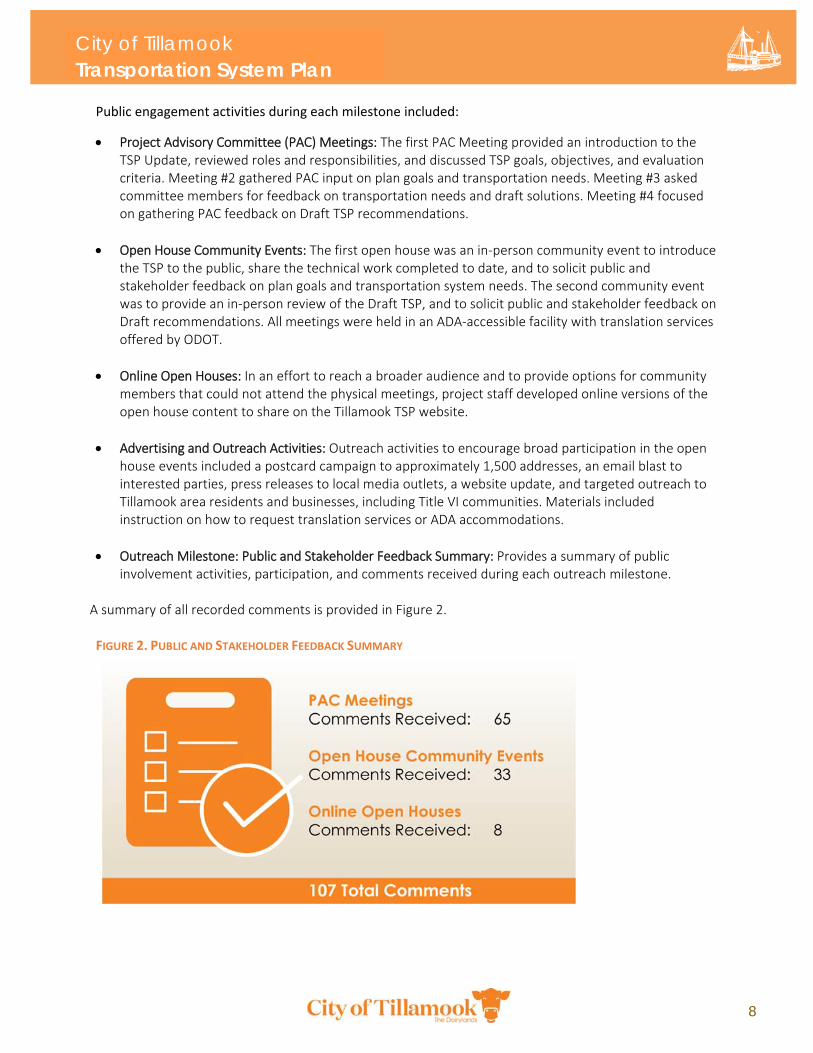
Public engagement activities during each milestone included:
Project Advisory Committee (PAC) Meetings: The first PAC Meeting provided an introduction to the TSP Update, reviewed roles and responsibilities, and discussed TSP goals, objectives, and evaluation criteria. Meeting #2 gathered PAC input on plan goals and transportation needs. Meeting #3 asked committee members for feedback on transportation needs and draft solutions. Meeting #4 focused on gathering PAC feedback on Draft TSP recommendations.
Open House Community Events: The first open house was an in‐person community event to introduce the TSP to the public, share the technical work completed to date, and to solicit public and stakeholder feedback on plan goals and transportation system needs. The second community event was to provide an in‐person review of the Draft TSP, and to solicit public and stakeholder feedback on Draft recommendations. All meetings were held in an ADA‐accessible facility with translation services offered by ODOT.
Online Open Houses: In an effort to reach a broader audience and to provide options for community members that could not attend the physical meetings, project staff developed online versions of the open house content to share on the Tillamook TSP website.
Advertising and Outreach Activities: Outreach activities to encourage broad participation in the open house events included a postcard campaign to approximately 1,500 addresses, an email blast to interested parties, press releases to local media outlets, a website update, and targeted outreach to Tillamook area residents and businesses, including Title VI communities. Materials included instruction on how to request translation services or ADA accommodations.
Outreach Milestone: Public and Stakeholder Feedback Summary: Provides a summary of public involvement activities, participation, and comments received during each outreach milestone.
A summary of all recorded comments is provided in Figure 2. FIGURE 2. PUBLIC AND STAKEHOLDER FEEDBACK SUMMARY
1-1
2.1 TSP Goals 2.2 Plans, Policies, and Standards 2.3 Evaluation Criteria
Chapter 2: Goals
10
Chapter 2: Goals and Policies This section establishes the goals and project evaluation framework used to develop the plan, including relevant plans, policies, and standards that informed the TSP Update.
2.1 TSP Goals These goals reflect the vision for Tillamook’s future based on input from the public and stakeholders, as
well as state goals, laws, and the Tillamook Comprehensive Plan These goals guided the TSP Update
process and informed the selection of projects, programs, and policies contained in the plan.
Goal 1: Coordination Maintain a Transportation System Plan that is consistent with the goals and objectives of the City of
Tillamook, Tillamook County, the state, and the Tillamook County Transit District Transit Development
Plan.
Goal 2: Safety Provide a transportation system that is safe for all users.
Goal 3: Livability and Economic Vitality Provide a transportation system that balances transportation system needs with the community desire
to maintain a pleasant, economically vital City and support public health.
Goal 4: Accessibility and Connectivity Develop an interconnected, multimodal transportation system that connects all members of the
community to destinations within and beyond the City.
Goal 5: Mobility Provide a balanced, multimodal transportation system that supports the movement of people and
goods.
Goal 6: System Preservation Maintain and preserve existing transportation infrastructure and mitigate transportation impacts from
new development resulting in changes in land use to comply with state highway performance, mobility,
and access management standards.
Goal 7: Public Transportation Support cost‐effective and safe public transportation through and within Tillamook.
Goal 8: Pedestrian and Bicycle Facilities Create an interconnected system of pedestrian and bicycle facilities in Tillamook to encourage increased
travel by walking or bicycling.
City of Tillamook Transportation System Plan
11
Goal 9: Environment Provide a transportation system that balances travel needs with the need to protect the environment
and significant natural features.
Goal 10: Funding Develop local funding options and seek grants and financing, as appropriate, for City transportation
improvements identified in the TSP.
2.2 Policies The following policies help implement the TSP Update, support corresponding Tillamook Development
Code amendments, meet the requirements of the Transportation Planning Rule (TPR), and reflect state
goals and policies in the Oregon Transportation System Plan (OTP).
Goal 1: Coordination POLICIES
1‐1. Provide a transportation system that is consistent with other elements and objectives of the City
of Tillamook City Comprehensive Plan, Oregon Transportation Plan, The Tillamook County Transit
District Transit Development Plan, and other policy documents.
1‐2. Coordinate with the Port of Tillamook Bay regarding the Tillamook Airport, the Port of Tillamook
Bay Industrial Park and the Port of Tillamook Bay short line railroad.
1‐3. Coordinate land use and transportation decisions to efficiently use public infrastructure
investments to:
a. Maintain the mobility and safety of the roadway system
b. Foster compact development patterns13
c. Encourage the availability and use of cycling, walking and transit
d. Enhance livability and economic competitiveness
Goal 2: Safety POLICIES
2‐1. Work with the Port of Tillamook to improve the safety of rail crossings.
2‐2. Maintain safe crossings and facilities, including street lighting, for vehicles, bicycles and
pedestrians across highways and major arterials. Develop, maintain, and enhance lifeline and
evacuation routes in coordination with local, regional, state and private entities.
2‐3. Establish, seek funding for, maintain, and promote safe and efficient critical emergency
prioritization routes, including the route north of OR 131/OR 6 and the route to the Tillamook
Airport, which is a critical disaster recovery facility.
13 This refers to leveraging TSP investments to create a responsible and efficient transportation system within the Urban Growth Boundary.
City of Tillamook Transportation System Plan
12
2‐4. Effectively and safely manage vehicle, pedestrian, and bicycle traffic, prioritizing Safe Routes to
Schools programs and projects.
2‐5. Prioritize safety enhancements on US‐101 Main and Pacific Streets through downtown
Tillamook to improve safety for pedestrians, bicyclists, and vehicles. Consider implementing
traffic calming techniques at other locations, as identified in the Transportation System Plan and
as appropriate, consistent with the Neighborhood Traffic Management tools and strategies.
2‐6. Consider transportation system resiliency when developing and designing transportation
projects of all kinds.
Goal 3: Livability and Economic Vitality POLICIES
3‐1. Minimize adverse social, economic and environmental impacts created by the transportation
system, including balancing the need for street connectivity and the need to minimize cut‐
through traffic and speeding in neighborhoods.
3‐2. Preserve, protect and ensure access to the City's significant natural features and historic sites,
including the Tillamook County Pioneer Museum.
3‐3. Improve transportation facilities and minimize traffic congestion in the downtown commercial
area without major disruption to downtown character.
3‐4. Promote pedestrian‐oriented design and the provision of pedestrian amenities in the downtown
area, such as pedestrian‐scale lighting and street trees.
3‐5. Ensure adequate vehicle and bicycle parking and parking signage in the downtown commercial
area, using techniques such as shared parking areas where appropriate.
3‐6. Balance the needs of maintaining access to the Hampton Lumber Company site and of
enhancing neighborhood livability.
3‐7. Collaborate with event managers to develop plans and actions for addressing event‐based traffic
congestion and safety issues, including the ability for emergency vehicles to access facilities.
3‐8. Implement land use compatibility and safety standards to promote air navigational safety at the
Tillamook Airport, preserve airport operations, and reduce potential safety hazards for persons
living, working or recreating near the airport.
3‐9. Preserve and maintain designated freight routes to accommodate freight system efficiency,
access, connectivity, and travel reliability for local freight haulers while maintaining the needs of
other users.
3‐10. As property along state highways redevelop, consider opportunities for access consolidation or
shared access to reduce connections to improve access spacing.
City of Tillamook Transportation System Plan
13
Goal 4: Accessibility and Connectivity POLICIES
4‐1. Consider the needs of people who are transportation disadvantaged when developing
alternatives to meet travel needs.
4‐2. Continue to upgrade existing transportation facilities and work with public transportation
providers to provide services that improve access for all users.
4‐3. Maintain safe and direct travel routes for pedestrians, bicyclists and those using mobility
devices.
4‐4. Promote designated freight routes and route alternatives to ease adverse impacts (congestion,
noise, safety) of commercial truck traffic in town.
4‐5. Provide a network of arterials, collectors and local streets that are interconnected, appropriately
spaced and reasonably direct in accordance with City and state design standards and the
Transportation System Plan.
4‐6. Minimize travel distances and vehicle‐miles traveled by requiring connected street grids and
limiting cul‐de‐sac developments.
4‐7. Expand pedestrian, bicycle, and transit‐supportive infrastructure through multi‐use paths, trails,
sidewalks, bikes lanes, and other facilities.
4‐8. Balance local circulation, safety, and access with freight and public transportation needs.
Goal 5: Mobility POLICIES
5‐1. Balance the safe and efficient movement of motor vehicles, pedestrians, bicyclists, transit,
trucks, and trains within and through Tillamook.
5‐2. Maintain appropriate levels of service on City streets and meet state and local mobility
standards.
5‐3. Limit access points on highways in accordance with state standards, and on arterials using
techniques such as alternative access points when possible to preserve mobility.
5‐4. Maintain access management standards for new development and existing access problems to
preserve the safe and efficient operation of roadways, consistent with functional classification.
5‐5. Balance mobility on the state highway system with community livability.
Goal 6: System Preservation POLICIES
6‐1. Maintain and preserve the roadways within the City of Tillamook in a state of good repair.
6‐2. Preserve locations for potential future transportation connections, as identified in the
Transportation System Plan.
City of Tillamook Transportation System Plan
14
6‐3. Develop an equitable system where developers aid in the development of the transportation
system by contributing a fair and proportionate share toward on‐site and off‐site transportation
system improvements. Where appropriate, this will include dedicating or reserving needed
rights‐of‐way, constructing half or full street improvements and constructing off‐street
pedestrian, bicycle and transit facilities needed to serve new development.
6‐4. Prioritize sidewalk pavement improvements for the downtown area.
6‐5. Shift vehicular travel to off‐peak periods by encouraging Transportation Demand Management
(TDM) strategies, as identified in the adopted Transportation System Plan.
6‐6. Improve travel reliability and safety with Transportation System Management strategies
identified in the Transportation System Plan, including employing advanced technologies and
management techniques to increase the efficiency of existing transportation infrastructure.
Goal 7: Public Transportation POLICIES
7‐1. Work with the public transportation providers to develop transit systems, stations, and related
facilities in convenient and appropriate locations.
7‐2. Improve signage and amenities at transit stops and stations.
7‐3. Work with public transportation providers to expand seasonal transit service as necessary
during summer months of peak travel.
7‐4. Coordinate with public transportation providers to identify and address the public
transportation needs of people who are transportation disadvantaged.
7‐5. Increase north‐south service frequency to heavily‐trafficked areas.
7‐6. Provide annual incremental route expansion as necessary to meet transit demand.
7‐7. Provide transit pull‐outs on City, state, and county facilities.
7‐8. Add additional shelters at stops where there are none.
7‐9. Advertise and promote TCTD services in the City of Tillamook.
7‐10. Coordinate TCTD, ODOT, and Tillamook County efforts to explore the need for implementing
TDM measures, such as carpooling and vanpooling in the County.
Goal 8: Pedestrian and Bicycle Facilities POLICIES
8‐1. Maintain and enhance safe, attractive and convenient pedestrian and bicycle facilities in the
downtown area, accessing transit, parks, medical facilities, public open space, and with new
development.
8‐2. Preserve and enhance the Oregon Coast Bike Route along U.S. 101 to support bicycle tourism.
City of Tillamook Transportation System Plan
15
8‐3. Support implementation and refinement of important regional trails, including the Salmonberry
Trail, Three Capes Scenic Loop, the Oregon Coast Trail, the National Water Recreation Trail and
access to Tillamook’s waterways.
8‐4. Work to develop safe, connected pedestrian and bicycle facilities near schools, residential and
commercial districts, and complete pedestrian loops envisioned in the Parks and Recreation
Master Plan.
8‐5. Support the development of bicycle facilities on all highways, arterial streets, major collectors,
and minor collectors.
8‐6. Use unused rights‐of‐way for greenbelts, walking trails or bike paths where appropriate.
8‐7. Encourage bicycle parking facilities in conjunction with new commercial, employment, and
multi‐family developments, transit stations, and schools and other institutional land uses to
encourage travel by bicycle.
8‐8. Implement findings from the Tillamook Wayfinding Plan.
8‐9. Implement traffic calming on US‐101 Main and Pacific Avenues through downtown Tillamook,
building on recent crossing improvements from the US‐101/OR‐6 Traffic Improvement Project.
8‐10. Consider seasonal parking policies to accommodate peak bicycle use during busy season without
permanent parking removal.
Goal 9: Environment POLICIES
9‐1. Promote a transportation system that encourages energy conservation through an efficient
street grid.
9‐2. Encourage use of active transportation and transit and development that minimizes reliance on
the automobile.
9‐3. Minimize transportation impacts on coastal and inland natural resources.
9‐4. Encourage improvements that minimize the impacts associated with frequent flooding.
9‐5. Support the reduction of greenhouse gas emissions from transportation sources, including
promoting travel options that allow individuals to reduce single‐occupant vehicle trips, such as
carpooling, public transit, walking, and bicycling.
Goal 10: Funding POLICIES
10‐1. Prioritize funding of projects that are most effective at meeting the goals and policies of the
Transportation System Plan.
10‐2. Develop and implement a transportation impact fee program to collect funds from new
developments to be used for off‐site and on‐site transportation improvements.
City of Tillamook Transportation System Plan
16
10‐3. Seek funding opportunities for a range of projects in coordination with county, state and federal
agencies.
10‐4. Implement improvements that meet applicable local, county, state and federal plans, standards
and criteria.
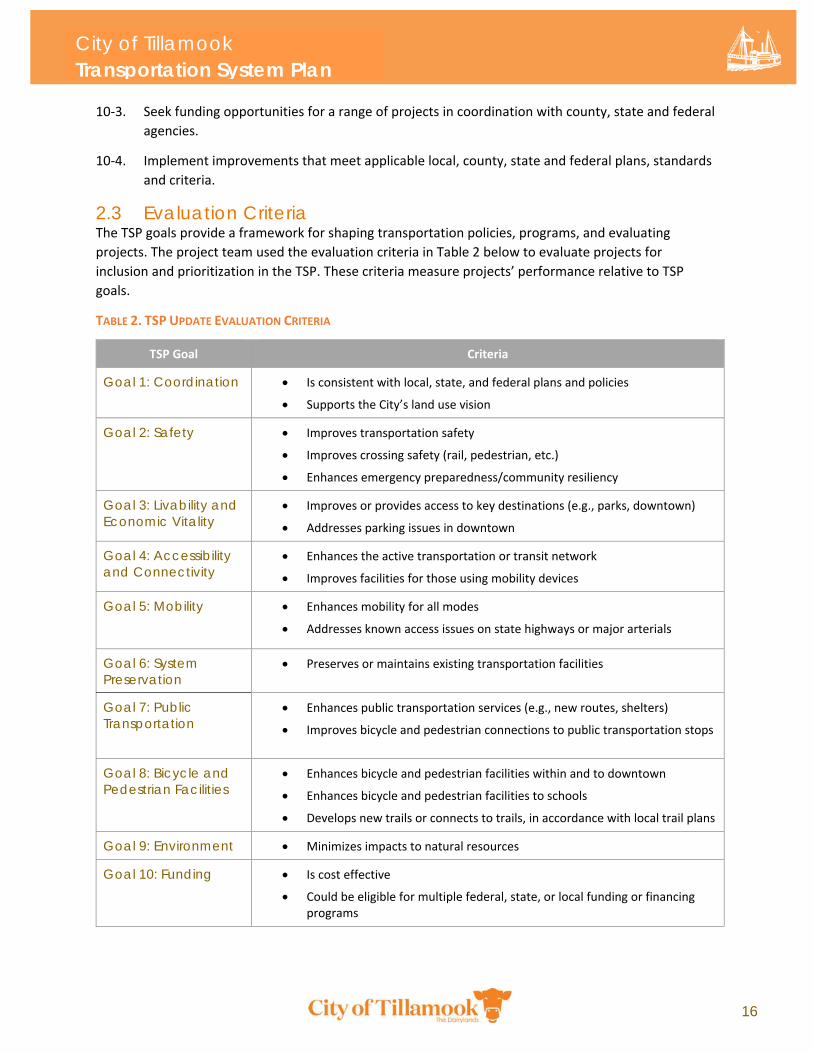
2.3 Evaluation Criteria The TSP goals provide a framework for shaping transportation policies, programs, and evaluating
projects. The project team used the evaluation criteria in Table 2 below to evaluate projects for
inclusion and prioritization in the TSP. These criteria measure projects’ performance relative to TSP
goals.
TABLE 2. TSP UPDATE EVALUATION CRITERIA
TSP Goal Criteria
Goal 1: Coordination Is consistent with local, state, and federal plans and policies
Supports the City’s land use vision
Goal 2: Safety Improves transportation safety
Improves crossing safety (rail, pedestrian, etc.)
Enhances emergency preparedness/community resiliency
Goal 3: Livability and Economic Vitality
Improves or provides access to key destinations (e.g., parks, downtown)
Addresses parking issues in downtown
Goal 4: Accessibility and Connectivity
Enhances the active transportation or transit network
Improves facilities for those using mobility devices
Goal 5: Mobility Enhances mobility for all modes
Addresses known access issues on state highways or major arterials
Goal 6: System Preservation
Preserves or maintains existing transportation facilities
Goal 7: Public Transportation
Enhances public transportation services (e.g., new routes, shelters)
Improves bicycle and pedestrian connections to public transportation stops
Goal 8: Bicycle and Pedestrian Facilities
Enhances bicycle and pedestrian facilities within and to downtown
Enhances bicycle and pedestrian facilities to schools
Develops new trails or connects to trails, in accordance with local trail plans
Goal 9: Environment Minimizes impacts to natural resources
Goal 10: Funding Is cost effective
Could be eligible for multiple federal, state, or local funding or financing programs
3.1 Functional Classification Plan 3.2 Streets System Plan 3.3 Pedestrian, Bicycle, and Multi-Use
Path Plan 3.4 Public Transportation System Plan 3.5 Freight Plan 3.6 Rail 3.7 Aviation 3.8 Marine Transportation 3.9 Pipelines
Chapter 3: Transportation System Plan
18
Chapter 3: Transportation System Plan This section describes the long-range plan for Tillamook’s transportation system. TSP projects are comprised of programs, policies, and capital projects that respond to current and future transportation needs and deficiencies in the City. The system plan seeks to balance priorities for all users of Tillamook’s transportation system, including those travelling by car, bike, on foot, or transit and to provide a long-range investment strategy that reflects the values of Tillamook’s community. The planning process to develop the TSP projects included a
review of the existing transportation system, current and
future transportation needs, an evaluation of potential
solutions, and the development of a funding and
implementation plan to arrive at a final list of projects. The
TSP is based on technical analysis performed by the project
team as well as input received from City staff, the Project
Advisory Committee (PAC), and community stakeholders.
Some of the projects in this section were included in the
original 2003 TSP; other projects are new to the TSP Update.
The 2003 Tillamook TSP identified several improvements to
improve pedestrian, bicycle, and vehicle safety in the
downtown area, including changes to intersections on US‐101
and a recommendation for consideration as a Special
Transportation Area (STA), which the Oregon Department of
Transportation (ODOT) subsequently conferred. Many of the
projects described in this section are derived from the 2003
TSP and the 2016 Hoquarton Waterfront Plan. The Hoquarton
Waterfront Plan and subsequent amendments have been
recently adopted by the City and the projects it contains will be
carried forward as part of the TSP Update. The City of
Tillamook is the lead for all projects unless otherwise noted.
Planning level cost estimates and funding priorities are included for all projects and strategies. It’s
important to note that all cost estimates are reported current construction dollars and are not adjusted
for future escalation. Priority is discussed in terms of implementation timeframe. Project timeframes
The Hoquarton Waterfront Plan (2016) provided a blueprint for future commercial, light industrial, residential, and recreational development in the Tillamook town center. The Plan identified projects and programs in four key focus areas in the Hoquarton area. Many of these projects are incorporated into this TSP Update.
City of Tillamook Transportation System Plan
19
are designated as either short‐ (0 – 5 years) or long‐term (5 – 20 year). Projects identified as community
priorities were designated as short‐term projects while lower‐priority projects requiring additional
refinement, analysis, or funding opportunities were designated as long‐term projects. Project timelines
also considered current and future available funding for capital projects and programs. The City of
Tillamook is considered the lead for all projects, although projects on state or port facilities, or
improvements to the City’s transit system assume partnership with the Oregon Department of
Transportation (ODOT), the Port of Tillamook Bay (POTB), and Tillamook County Transportation District
(TCTD) unless noted otherwise. This TSP is not financially constrained.
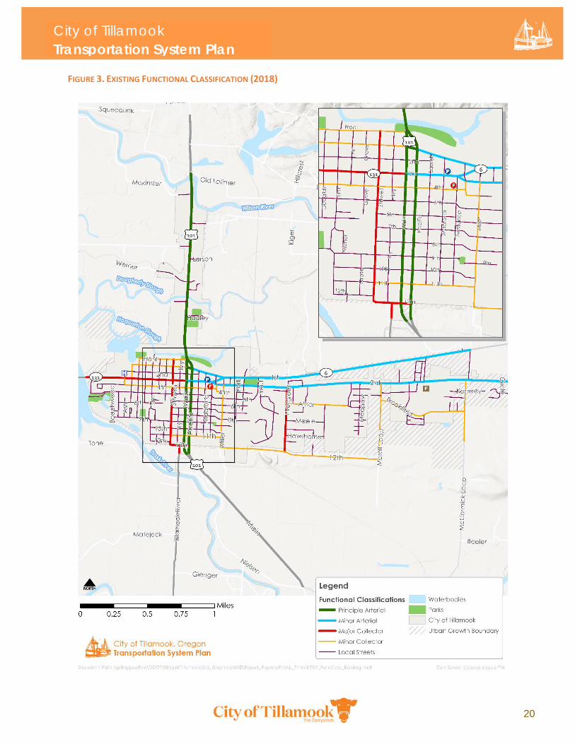
3.1 Functional Classification Plan The City’s functional classification system describes the intended function of City streets and is an
important tool for organizing and managing the roadway network. The street functional classification
system recognizes that individual streets do not act independently of one another, but instead form a
network that works together to serve travel needs on a local and regional level. By designating the
management and design requirements for each roadway classification, the hierarchal system supports a
network of streets that perform as desired. Roadways are functionally classified as Principle or Minor
Arterial, Collector, or Local Roadways. Complete descriptions of each functional classification are
provided in Appendix E: Existing Conditions.
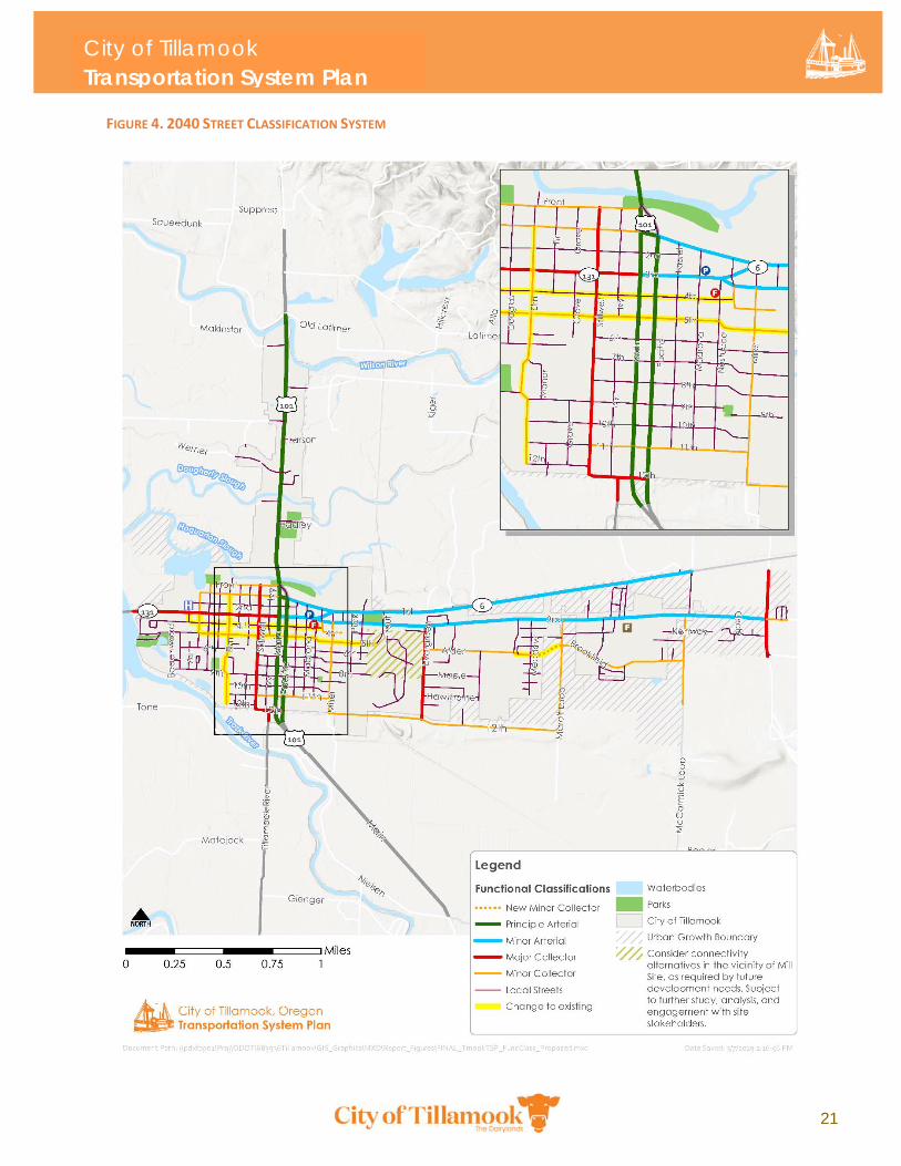
2040 Functional Classification System The existing (2018) and 2040 functional classification systems for roadways in the City of Tillamook are
shown in Figures 3 and 4 below. The 2040 functional classification system includes new street
extensions proposed as part of the TSP Roadway System (see section 3.2 below). Figure 4 shows changes
to the existing functional classification in yellow highlighter.
Classifications shown for County roads inside the Tillamook Urban Growth Boundary reflect the City’s
desired function for those facilities. These classifications may not match those shown in Tillamook
County’s TSP. However, Tillamook County policy is to apply City standards to County facilities within the
Urban Growth Boundary. Therefore, it is anticipated that Tillamook standards will be applied to County
roads. Key changes to the 2018 functional classification are as follows:
Reclassify Elm Street from 1st Street to 12th Street as a Minor Collector to provide improved north‐south connectivity through the City.
Reclassify 4th Street from a Minor Collector to a Local Street.
Reclassify 5th Street from Birch Avenue and Delmonte Avenue, and Birch Avenue from 5th to 3rd Streets as Minor Collectors to provide an improved future east‐west connection through the City. In addition, it will also provide better spacing and separation from the designated Major Collector on 3rd Street.
Reclassify Dogwood Avenue as a Minor Collector.
City of Tillamook Transportation System Plan
20
FIGURE 3. EXISTING FUNCTIONAL CLASSIFICATION (2018)
City of Tillamook Transportation System Plan
21
FIGURE 4. 2040 STREET CLASSIFICATION SYSTEM
City of Tillamook Transportation System Plan
22
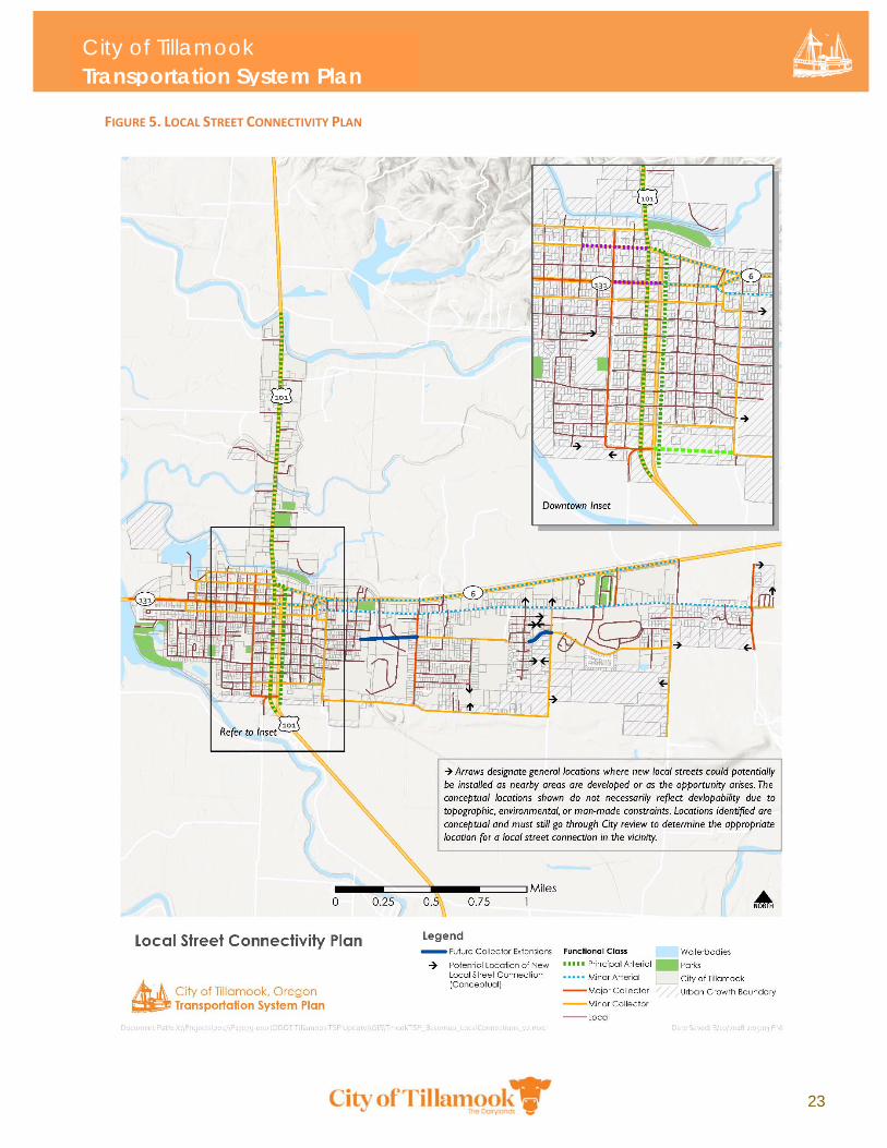
Local Street Connectivity Local street connectivity is required by the state Transportation Planning Rule (OAR 660‐012) and is
important for Tillamook’s continued development. Providing adequate connectivity can reduce the need
for wider roads, traffic signals, and turn lanes. Increased connectivity can reduce a city’s overall vehicle
miles traveled (VMT), balance the traffic load on major facilities, encourage residents to seek out other
travel modes, and reduce emergency vehicle response times. While improvement to local street
connectivity is easier to implement in developing areas, retrofitting existing areas to provide greater
connectivity should also be attempted.
Tillamook’s existing street connectivity is constrained by highways, natural features such as streams and
wetlands, and by undeveloped areas of future development. The proposed Local Street Connectivity
Plan shown in Figure 5 identifies approximate locations where new local street connections should be
installed as areas continue to develop. The locations identified in Figure 5 are not an exhaustive list of all
future local street connections. Rather, the purpose of the maps is to ensure that new developments
accommodate circulation between adjacent neighborhoods to improve connectivity for all modes of
transportation. Additional connections to improve the street network grid are not shown.
These locations included in Figure 5 are general locations where new local streets could potentially be
installed as nearby areas are developed or as the opportunity arises. The conceptual locations shown do
not necessarily reflect developability due to topographic, environmental, or manmade constraints.
Locations identified are conceptual and must still go through City review to determine the appropriate
location for a local street connection in the vicinity.
The design and construction of new connecting streets should evaluate whether neighborhood traffic
management strategies are necessary to protect existing neighborhoods from potential traffic impacts
caused by extending stub end streets. To establish appropriate expectations, the City should require the
installation of signs indicating the potential for future connectivity when development constructs stub
streets.
3.2 Roadway System Plan Roadway System Conditions The following section existing conditions, needs, and deficiencies to the various roadway elements for
vehicle travel in Tillamook, including intersection operations, network connectivity, roadway geometry,
safety, access management, and pavement conditions.
Operational Deficiencies Future (2040) PM peak hour traffic operations were evaluated at 20 study intersections for the seasonal
summer peak. One intersection, Evergreen Drive and 3rd Street, has a level of service (LOS) F, which
exceeds the mobility target of LOS D for a City minor approach. The critical movement at this
intersection is the northbound left turn. Under existing conditions, this intersection approach operates
at LOS E, with a v/c ratio of 0.58, which would increase with traffic growth projected to occur along 3rd
Street. All other study intersections meet mobility targets under both existing and 2040 conditions.
City of Tillamook Transportation System Plan
23
FIGURE 5. LOCAL STREET CONNECTIVITY PLAN
City of Tillamook Transportation System Plan
24
Safety Needs Multiple locations along US‐101, OR‐6, and 3rd Street were identified as safety focus areas based on
observed crash rates and frequency of crash types. Most of these locations are less than one half mile in
length and are disproportionately impacted by clusters of collisions near intersections14. Further
investigation would be required to identify segments that would benefits from safety countermeasures.
The Tillamook Planning Commission noted that a future transportation study should be considered in
the vicinity of 12th and Main/Pacific Streets (US 101). The Commission identified potential safety and
traffic concerns at this intersection that were not identified during the TSP development process. The
study area and scope should be refined by the City before engaging with potential partners, such as
ODOT, to conduct the study and incorporate any findings into the TSP.
Access Management State highways in Tillamook generally do not meet ODOT access spacing standards as defined in the
Oregon Highway Plan (Table 3). This is primarily due to business development along most of the
corridors prior to implementation of current access management standards. In the downtown area,
there are often multiple private driveways between blocks, which can lead to vehicular and pedestrian
conflicts. The City has attempted to mitigate this by abandoning accesses on Federal Emergency
Management Agency (FEMA) purchased properties with multiple driveways, as well as consolidating
highway access points to adjoining parcels.
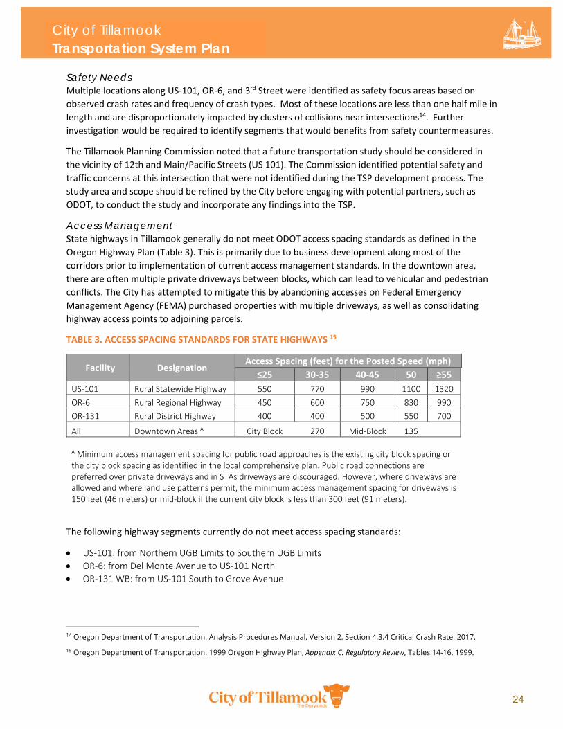
TABLE 3. ACCESS SPACING STANDARDS FOR STATE HIGHWAYS 15
Facility Designation Access Spacing (feet) for the Posted Speed (mph)
≤25 30‐35 40‐45 50 ≥55
US‐101 Rural Statewide Highway 550 770 990 1100 1320
OR‐6 Rural Regional Highway 450 600 750 830 990
OR‐131 Rural District Highway 400 400 500 550 700
All Downtown Areas A City Block 270 Mid‐Block 135
A Minimum access management spacing for public road approaches is the existing city block spacing or the city block spacing as identified in the local comprehensive plan. Public road connections are preferred over private driveways and in STAs driveways are discouraged. However, where driveways are allowed and where land use patterns permit, the minimum access management spacing for driveways is 150 feet (46 meters) or mid‐block if the current city block is less than 300 feet (91 meters).
The following highway segments currently do not meet access spacing standards:
US‐101: from Northern UGB Limits to Southern UGB Limits
OR‐6: from Del Monte Avenue to US‐101 North
OR‐131 WB: from US‐101 South to Grove Avenue
14 Oregon Department of Transportation. Analysis Procedures Manual, Version 2, Section 4.3.4 Critical Crash Rate. 2017.
15 Oregon Department of Transportation. 1999 Oregon Highway Plan, Appendix C: Regulatory Review, Tables 14-16. 1999.
City of Tillamook Transportation System Plan
25
Neighborhood Traffic Calming No specific neighborhood traffic calming treatments are included in the TSP. A toolbox of neighborhood
traffic calming applications is provided in Appendix G: Future Needs of the TSP.
System Connectivity Tillamook’s existing street connectivity is constrained by highways, natural features such as streams and
wetlands, and by undeveloped areas of future development. In general, arterial spacing of
approximately one‐mile, collector spacing of approximately half‐mile, and additional connectivity
provided by lower level streets provides an ideal street system for mobility and connectivity. Providing
adequate connectivity can reduce the need for wider roads, traffic signals, and turn lanes. Increased
connectivity can reduce a City’s overall vehicle miles traveled (VMT), balance the traffic load on major
facilities, encourage residents to seek out other travel modes, and reduce emergency vehicle response
times. Local street connectivity is required by the state Transportation Planning Rule (OAR 660‐012) and
is important for Tillamook’s continued development. While improvements to local street connectivity
are easier to implement in developing areas, the City may also consider retrofitting existing areas.
North‐south connectivity is served by several routes, including primarily US‐101. East‐west connectivity
is limited, however, due to existing development between downtown and the eastern part of the City.
Connectivity gaps are summarized below:
Through Route Gap: The network southwest of downtown lacks a defined through route (minor collector). Current local through routes are 9th Street and Cedar Avenue.
East‐West Connectivity Gap: The network east of downtown lacks a major collector east‐west route. Ideally, it should be spaced approximately within a half‐mile from the nearest arterial, 3rd Street. The existing alignment of 12th Street meets the spacing threshold, but the facility is classified as a minor collector, and a gap exists between Marolf Loop Road and McCormick Loop.
Missing Roadway Connection: There is a roadway connectivity gap on 12th Street between Miller Avenue and US‐101 (Pacific Avenue). Such a connection would provide a direct collector connection between downtown and the east side of town. However, due to topography, wetlands, and Holden Creek, such a connection in direct alignment with 12th Street is not feasible. This location is targeted for a pedestrian connection. Alternate roadway improvements may be considered to fill this connectivity need.
Downtown Connectivity Gap: There is a connectivity gap between downtown and eastern Tillamook at the mill site. There is a half‐mile gap in both the north‐south and east‐west directions
East Connectivity Gap: There is no defined north‐south collector connection from OR 6 to another east‐west collector on the east side of town. There are also other minor collector east‐west connectivity gaps between 3rd Street and 12th Street, e.g. between Alder Lane and Brookfield Avenue.
Pavement Conditions Pavement conditions in Tillamook vary, although most streets will require some level of maintenance
and repair within 5 years of the writing of this plan. The ODOT Pavement Management System requires
biennial pavement condition reports for all state mainline highways within the City. As of the writing of
this plan, pavement condition survey work was last completed in the Summer of 2018, with the next
report scheduled for 2020. Within City limits, pavement conditions on US‐101 range from fair to poor,
except where recent improvements have been made as part of the OR‐6/US‐101 Traffic Improvement
project. Pavement conditions along OR‐131/OR‐6 range from good to very good, except for the
City of Tillamook Transportation System Plan
26
segment between US‐101/NB Pacific Avenue and Delmonte Avenue which was assessed to be in poor
condition.
Most local streets within the City need griding/paving or chip seal within the next 5 years. Some streets,
including segments of Douglas, Grove, 7th, 8th, and 9th Streets have been assessed to be in such poor
condition that they need to be completely rebuilt within 5 years. Few streets, such as segments of
Nestucca, 6th, and 4th Streets currently have minimal maintenance needs such as concrete street
patching and pothole infill. Generally speaking, the local street network on the east side of town is in
good condition, with substantial portions of Evergreen, 12th, Alder, and OR‐6/3rd Streets requiring no
near‐term maintenance or repair. Pavement conditions on streets near Tillamook Medical Center
including segments of Beechwood, 4th, 5th, and Cedar Streets have also been assessed to be in good
repair. Figures 6‐8 below display pavement conditions on local streets. Figure 9 displays pavement
conditions on US‐101, OR‐6, and OR‐131.
Failure to keep roads in a state of good repair has exponentially greater costs than maintaining the
system properly over time. Pavements degrade over time and must be resurfaced or rehabilitated
periodically to keep them in acceptable conditions. Resurfacing on a regular cycle helps confine
degradation to the pavement’s surface while protecting the foundation and base layers, avoiding the
need for complete replacement. If resurfacing is delayed for too long, the foundation can become
damaged and complete replacement becomes necessary at much higher cost.16 Timely maintenance and
preservation by performing the right treatment to the right road at the right time is by far the most
efficient way to preserve the City’s investment.
16 The typical cost to preserve pavement through resurfacing is about $200,000 for each lane mile, while reconstructing that same lane mile after it fails can reach $1.5 million. Source: ODOT Pavement Unit (2019).
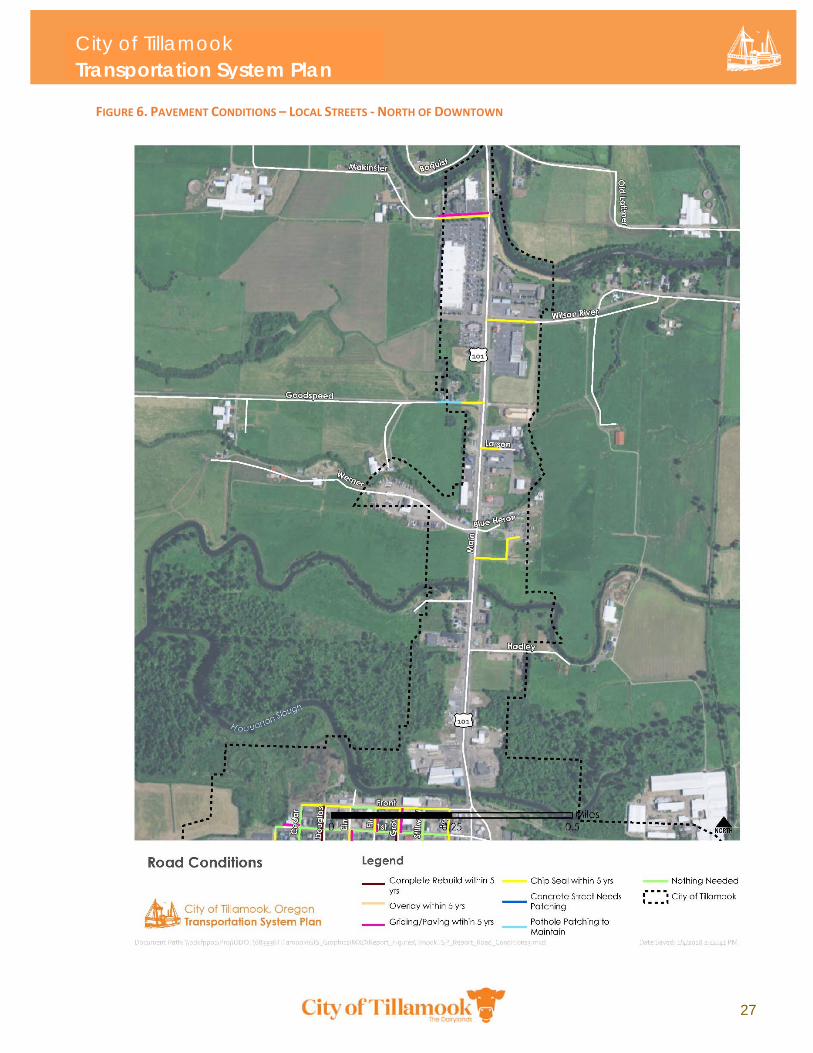
City of Tillamook Transportation System Plan
27
FIGURE 6. PAVEMENT CONDITIONS – LOCAL STREETS ‐ NORTH OF DOWNTOWN
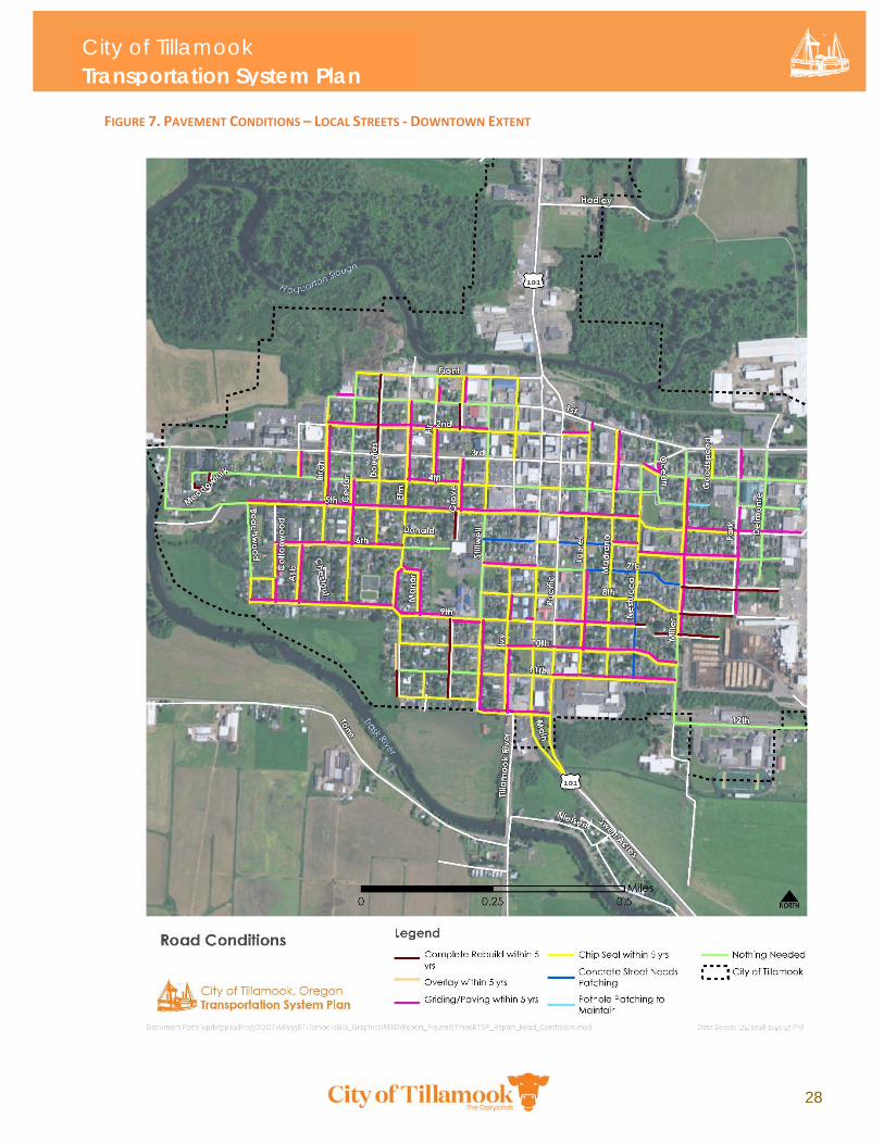
City of Tillamook Transportation System Plan
28
FIGURE 7. PAVEMENT CONDITIONS – LOCAL STREETS ‐ DOWNTOWN EXTENT
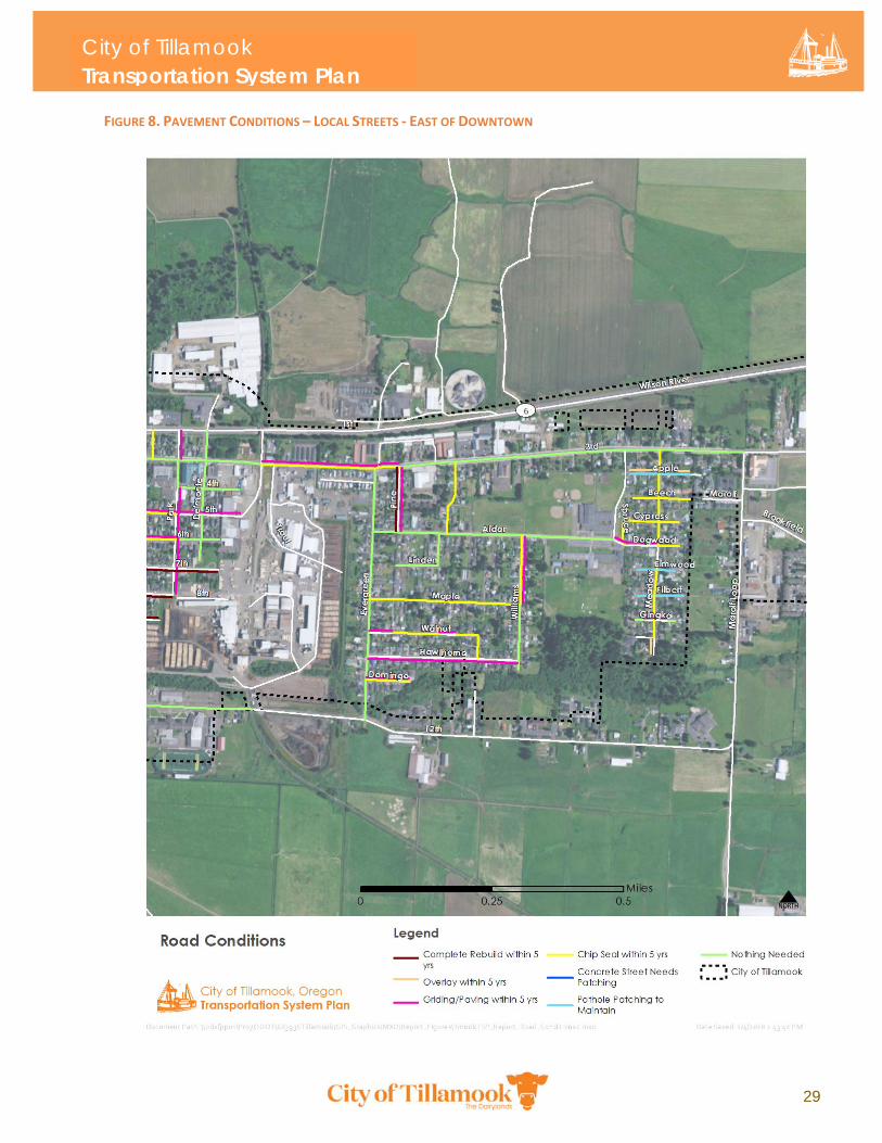
City of Tillamook Transportation System Plan
29
FIGURE 8. PAVEMENT CONDITIONS – LOCAL STREETS ‐ EAST OF DOWNTOWN
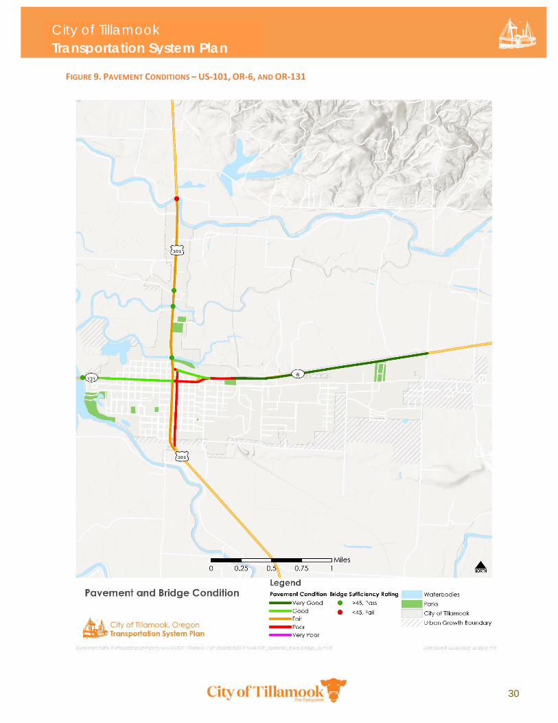
City of Tillamook Transportation System Plan
30
FIGURE 9. PAVEMENT CONDITIONS – US‐101, OR‐6, AND OR‐131
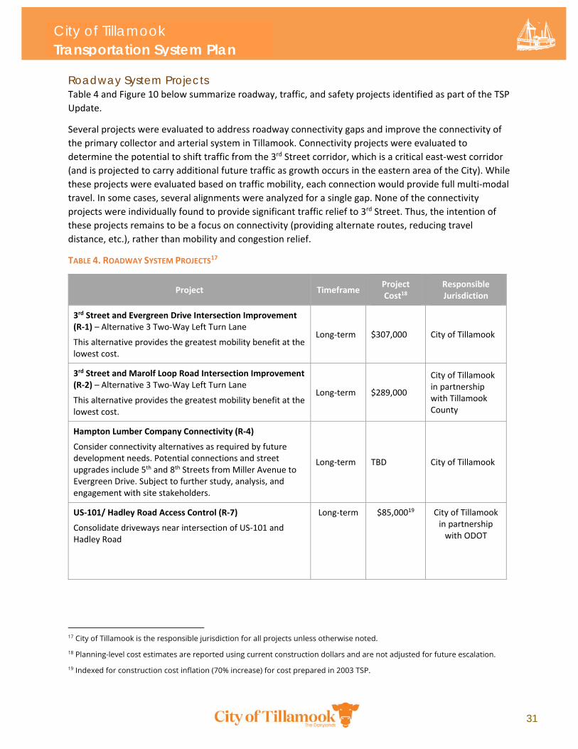
City of Tillamook Transportation System Plan
31
Roadway System Projects Table 4 and Figure 10 below summarize roadway, traffic, and safety projects identified as part of the TSP
Update.
Several projects were evaluated to address roadway connectivity gaps and improve the connectivity of
the primary collector and arterial system in Tillamook. Connectivity projects were evaluated to
determine the potential to shift traffic from the 3rd Street corridor, which is a critical east‐west corridor
(and is projected to carry additional future traffic as growth occurs in the eastern area of the City). While
these projects were evaluated based on traffic mobility, each connection would provide full multi‐modal
travel. In some cases, several alignments were analyzed for a single gap. None of the connectivity
projects were individually found to provide significant traffic relief to 3rd Street. Thus, the intention of
these projects remains to be a focus on connectivity (providing alternate routes, reducing travel
distance, etc.), rather than mobility and congestion relief.
TABLE 4. ROADWAY SYSTEM PROJECTS17
Project Timeframe Project Cost18
Responsible Jurisdiction
3rd Street and Evergreen Drive Intersection Improvement (R‐1) – Alternative 3 Two‐Way Left Turn Lane
This alternative provides the greatest mobility benefit at the lowest cost.
Long‐term $307,000 City of Tillamook
3rd Street and Marolf Loop Road Intersection Improvement (R‐2) – Alternative 3 Two‐Way Left Turn Lane
This alternative provides the greatest mobility benefit at the lowest cost.
Long‐term $289,000
City of Tillamook in partnership with Tillamook County
Hampton Lumber Company Connectivity (R‐4)
Consider connectivity alternatives as required by future development needs. Potential connections and street upgrades include 5th and 8th Streets from Miller Avenue to Evergreen Drive. Subject to further study, analysis, and engagement with site stakeholders.
Long‐term TBD City of Tillamook
US‐101/ Hadley Road Access Control (R‐7)
Consolidate driveways near intersection of US‐101 and Hadley Road
Long‐term $85,00019 City of Tillamook in partnership with ODOT
17 City of Tillamook is the responsible jurisdiction for all projects unless otherwise noted.
18 Planning-level cost estimates are reported using current construction dollars and are not adjusted for future escalation.
19 Indexed for construction cost inflation (70% increase) for cost prepared in 2003 TSP.
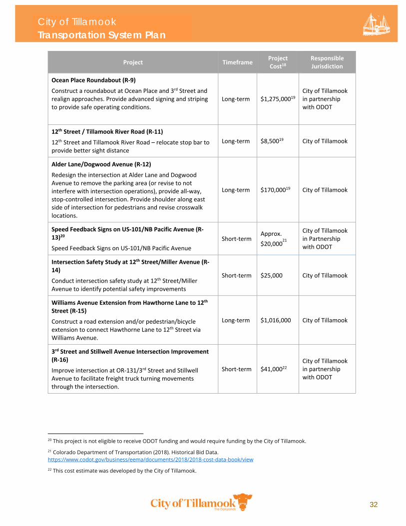
City of Tillamook Transportation System Plan
32
Project Timeframe Project Cost18
Responsible Jurisdiction
Ocean Place Roundabout (R‐9)
Construct a roundabout at Ocean Place and 3rd Street and realign approaches. Provide advanced signing and striping to provide safe operating conditions.
Long‐term $1,275,00019 City of Tillamook in partnership with ODOT
12th Street / Tillamook River Road (R‐11)
12th Street and Tillamook River Road – relocate stop bar to provide better sight distance
Long‐term $8,50019 City of Tillamook
Alder Lane/Dogwood Avenue (R‐12)
Redesign the intersection at Alder Lane and Dogwood Avenue to remove the parking area (or revise to not interfere with intersection operations), provide all‐way, stop‐controlled intersection. Provide shoulder along east side of intersection for pedestrians and revise crosswalk locations.
Long‐term $170,00019 City of Tillamook
Speed Feedback Signs on US‐101/NB Pacific Avenue (R‐13)20
Speed Feedback Signs on US‐101/NB Pacific Avenue
Short‐term Approx.
$20,00021
City of Tillamook in Partnership with ODOT
Intersection Safety Study at 12th Street/Miller Avenue (R‐14)
Conduct intersection safety study at 12th Street/Miller Avenue to identify potential safety improvements
Short‐term $25,000 City of Tillamook
Williams Avenue Extension from Hawthorne Lane to 12th Street (R‐15)
Construct a road extension and/or pedestrian/bicycle extension to connect Hawthorne Lane to 12th Street via Williams Avenue.
Long‐term $1,016,000 City of Tillamook
3rd Street and Stillwell Avenue Intersection Improvement (R‐16)
Improve intersection at OR‐131/3rd Street and Stillwell Avenue to facilitate freight truck turning movements through the intersection.
Short‐term $41,00022 City of Tillamook in partnership with ODOT
20 This project is not eligible to receive ODOT funding and would require funding by the City of Tillamook.
21 Colorado Department of Transportation (2018). Historical Bid Data. https://www.codot.gov/business/eema/documents/2018/2018-cost-data-book/view
22 This cost estimate was developed by the City of Tillamook.
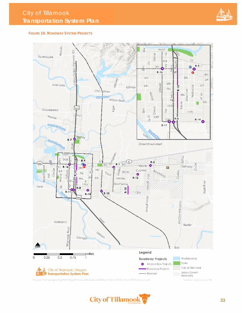
City of Tillamook Transportation System Plan
33
FIGURE 10. ROADWAY SYSTEM PROJECTS
City of Tillamook Transportation System Plan
34
3.3 Pedestrian and Bicycle System Plan Bicycle and Pedestrian System Conditions Tillamook’s bicycle and pedestrian system is comprised of on‐street bicycle facilities, sidewalks,
pedestrian crossings, curb ramps, and off‐street trails for pedestrians and bicyclists. The following
sections describes the conditions of the system based on an analysis of existing and future conditions,
including system needs on current and planned roadway segments throughout the City. See Appendix E
and Appendix F for more detailed information about bicycle and pedestrian conditions and needs in
Tillamook.
Sidewalks Tillamook’s arterial and collector sidewalk network is generally well‐developed in the core of the City.
Outside of downtown, however, sidewalk connectivity is inconsistent on arterial and collector streets.
Sidewalks are also deficient on portions of the local street network. Some neighborhoods have complete
sidewalks on both sides of the street, while others do not. In more recently developed residential areas,
newly constructed pedestrian facilities do not always connect to older parts of the City, resulting in a
disconnected network. Where local streets are lacking sidewalks, pedestrians must walk along paved or
gravel roadway shoulders. This can be adequate for roadways with low traffic volumes but is not
adequate on roads with high traffic volumes where pedestrians must share the roadway with moving
bicycles and vehicles.
Although sidewalk gaps affect pedestrian connectivity throughout the City, needs are greatest near
significant pedestrian generators, such as schools, parks, and community destinations. Deficiencies near
schools and community destinations can exist even when sidewalks are present. A sidewalk may present
on only one side of the street. In some locations, a high number of driveways and private accesses
create a barrier to safe and continuous pedestrian facilities.
Crossings Marked crosswalks, pedestrian signalization, curb “bulbouts”, and curb ramps facilitate the safe and
efficient movement of pedestrians. Numerous marked crosswalks are located throughout the City. The
current condition of crosswalk markings varies by location. At some places, crosswalks are marked on all
intersection approaches, but the striping is sometimes faded and difficult to see. The City’s current
crosswalk policy is to apply continental hash markings at any intersection where new paint or
reapplication is needed. “Advanced” crossing treatments are needed in places with greater safety
concerns and/or higher traffic volumes requiring a higher level of protection for pedestrians and other
vulnerable road users. Advanced crossing improvements at these locations may augment basic crossing
improvements and may include pedestrian signalization, raised crossings, curb bulbouts, and curb ramp
installation or reconstruction.
ADA Facilities Most sidewalks in downtown Tillamook have been upgraded with curb ramps. Generally, ramps in front
of newer development or commercial centers are ADA‐compliant. However, some of the older ramps in
downtown are not to ADA standard due to being too steep or cracked. Many sidewalks do not have
ADA‐compliant sidewalk ramps, although most sidewalks meet minimum ADA width and maximum
slope standards. In other cases, curb ramps are not present on all intersection approaches. West of
Stillwell Avenue, curb ramps are missing at some or all intersection approaches on Front Street, OR‐
City of Tillamook Transportation System Plan
35
6/OR‐131 1st and 3rd Streets, and 4th Street. ADA ramp improvements are needed along 5th Street at
every intersection except at Madrona, Stillwell, and US‐101 SB Main/NB Pacific Avenues. Curb ramps
are also missing along most of OR‐6/ 1st Street east of US‐101 SB/ Pacific Avenue. For information about
ADA facilities on state highways, please refer to the ODOT Americans with Disabilities Act Title 11
Transition Plan Update.
East of Miller Avenue, there are currently no curb ramps along most of OR‐6/OR‐131 1st and 3rd Streets,
12th Street, most of Evergreen Drive, Marolf Loop Drive, Brookfield Avenue, or McCormick Loop Drive.
Additional sidewalk gaps on the arterial and collector network exist on one side of the street along Front
and 2nd Streets, between Birch and Stillwell Avenue.
Pedestrian Lighting Street lights are located on most roadways within the City, although many require upgrade, relocation,
or repair. On many streets, street light poles are widely spaced, creating illumination gaps for all road
users. Despite their presence on many roadways, nearly all the of City’s street lights are constructed to
illuminate the vehicle right‐of‐way as opposed to illuminating the pedestrian environment.
Pedestrian‐scale lighting only exists in a few locations throughout the City, and mostly within recently
improved parks and community centers. Pedestrian‐scale lighting is needed on the arterial system
within the downtown core, as well as near all schools, parks, and community centers within the City.
Opportunities exist to enhance pedestrian lighting within the local street network, particularly near
intersections with higher speed and/or higher volume roadway facilities. Existing and planned trails also
require adequate pedestrian lighting to ensure safe and comfortable use for pedestrians and bicycle
riders.
Bicycle Facilities Tillamook has a designated bicycle network recommended as part of the 2003 TSP, though as of 2018
the City’s transportation network has few dedicated bicycle facilities. As of the writing of this plan, the
only bicycle facilities that have been implemented on the City’s designated bicycle network are on US‐
101 and OR‐6, which consist of shoulder bike lanes without dedicated bicycle signage or striping.
Through downtown, bicyclists travelling along the US‐101 couplet (Main and Pacific Avenues) are
required to mix with vehicle traffic and are further limited by on‐street parking. Higher traffic volumes
from anticipated growth in certain areas of the City create a need to separate cyclists from motor
vehicles.
Much of the designated network consists of local low‐traffic streets where bicycle facilities may not be
warranted. Most of the existing bicycle facilities within the City require bicyclists to mix with traffic on
arterial and collector roadways. Several streets have striped shoulders that may be used by cyclists but
are not designated formally as bikeways. There are no dedicated bicycle facilities on Tillamook local
roads. Bicyclists are required to share the roadway with vehicle traffic and pedestrians.
Bicycle signage and markings are minimal throughout most of the City. The City recognizes that any
official components of the Tillamook bicycle system should be signed and/or marked as bicycle routes
per 1995 Oregon Bicycle and Pedestrian Plan standards. Many roads on the bike network need signage
and markings to meet this standard.
City of Tillamook Transportation System Plan
36
Trails and Multi-Use Paths The Hoquarton Interpretive Trail is the only multi‐use trail owned by the City, located along the banks of
the Hoquarton Slough in downtown Tillamook. Tillamook’s trail and multi‐use path system is considered
part of Tillamook’s pedestrian and bicycle system as it is shared by both pedestrians and bicyclists. City
staff have identified needed off‐street path and trail connections, including a planned shared‐use path
linking Hoquarton Interpretive Trail and Goodspeed Park, which is under construction as of this writing.
Other needed trails increase recreational access in and around parks and the Hoquarton Slough.
Pedestrian and Bicycle System Projects The TSP’s bicycle and pedestrian projects for the City’s arterial and collector network are summarized in
the tables and figures below. Improvements to local streets were not specifically assessed as part of the
TSP process, although some deficiencies on local streets were identified where warranted by
multimodal access and connectivity needs. Pedestrian and bicycle system projects are summarized in
Table 5 below.
TABLE 5. PEDESTRIAN AND BICYCLE SYSTEM23
Project Timeframe Project Cost24
Responsible Jurisdiction
Crossings
Crossing Improvements (C‐1 and C‐2)
There are 34 crossing improvements proposed. These are grouped into two bundles: Basic (C‐1) and Advanced (C‐2). However, it is not expected that all crossing improvements would be constructed as part of the same project or at the same time.
Short – Long‐term
$1,085,000
City of Tillamook in partnership with ODOT
Sidewalk Infill, Construction, and Streetscaping Improvements
Sidewalk Infill, Construction, and Streetscaping Improvements (P‐1 through P‐12)
There are 12 proposed sidewalk infill, construction, and streetscaping improvements, including 5 infill and streetscaping projects carried over from the Hoquarton Waterfront Plan (2016), and 1 project prioritizes ADA improvements on 5th Street. Sidewalk connectivity is prioritized in Safe Routes to School (SRTS) zones and in East Tillamook where the greatest gaps exist. Lower priority infill projects can be implemented over time.
Short – Long‐term
$3,231,000 City of Tillamook
Bicycle System
Shared Roadway Improvements (B‐1)
The TSP recommends shared roadway improvements on 10 segments within the City. Shared roadway segments were evaluated as a single project per the TSP’s methodology but may be constructed at different times or as part of other projects.
Short‐term $116,000 City of Tillamook
23 City of Tillamook is the responsible party for all projects unless otherwise noted.
24 Planning-level cost estimates are reported using current construction dollars and are not adjusted for future escalation.
City of Tillamook Transportation System Plan
37
Project Timeframe Project Cost24
Responsible Jurisdiction
Shared roadway improvements have a relatively low cost on a per mile basis and assume shared roadway markings and signage.
Bike Facilities (B‐2 and B‐4 through B‐7)
Five projects propose on‐street bike lanes. These enhance bicycle connections throughout the City with better facilities in specific locations.
Short‐term $474,000‐$735,000
City of Tillamook, in partnership with ODOT on some projects
Bicycle Plaza: Vicinity of 4th Street and Main Avenue
Assumes tubular bike rack for 8‐12 bicycles and overhead shelter. Short‐term
Approx. $8,000 ‐
$12,00025
City of Tillamook
Path and Multi‐Use Trail System
Off‐Street Path and Multi‐Use Trail Improvements (OS‐1 through OS‐5)
Five projects are proposed for improving off‐street travel and recreation opportunities in the City.
Long‐term $2,869,000
City of Tillamook, in partnership with the Port of Tillamook on OS‐5
25 Based on Staten Island Bicycle Parking Hardware Options Report (1998), published by Staten Island Bicycle Parking at Transit. Unit cost information assumes standard covered bike parking for less than 12 bicycles.
City of Tillamook Transportation System Plan
38
Sidewalk Infill, Construction, and Streetscaping Improvements (P-1 through P-12) The TSP includes 16 sidewalk infill, construction, and streetscaping improvements. Six streetscaping
projects carried over from the 2016 Hoquarton Waterfront Plan are enumerated with a single project ID
(P‐1). Sidewalk connectivity is prioritized in Safe Routes to School (SRTS) zones and in East Tillamook
where the greatest gaps exist in the pedestrian network. Lower priority sidewalk projects can be
implemented over time. Crossing improvements (C‐1 and C‐2) are summarized separately in Table 6 and
Figure 11 below. Implementation timeframes for these projects ranges from short to long term, to be
determined by the City based on local needs and available funding. Note that the TSP process
considered the collector and arterial network for sidewalk gaps.
TABLE 6. SIDEWALK INFILL, CONSTRUCTION, AND STREETSCAPE PROJECTS ‐ ARTERIAL AND COLLECTOR NETWORK
ID Project Description Project Cost Responsible Jurisdiction
P‐1 Streetscape ‐ 2nd Street, Fir Avenue to US‐101
Streetscape: sidewalk/curb rehabilitation (600 linear feet) between US‐101 and Fir Avenue to accommodate extension of one‐way section; roadway striping and signage through segment
$39,000 City of Tillamook
P‐1 Streetscape – Elm Street, 1st Street to 12th Street
Streetscape: sidewalk/curb rehabilitation (1,277 linear feet), pedestrian ramps, and roadway striping and signage
$142,000 City of Tillamook
P‐1 Streetscape ‐ Fir Avenue, Front Street to 2nd Street
Streetscape: sidewalk infill (875 linear feet), curb rehabilitation, pedestrian ramps, curb extensions, and roadway striping and signage.
$112,000 City of Tillamook
P‐1 Streetscape ‐ Grove Avenue, 1st Street to 2nd Street
Streetscape: sidewalk infill (500 linear feet), curb rehabilitation, pedestrian ramps, curb extensions, and roadway striping and signage.
$78,000 City of Tillamook
P‐1 Streetscape ‐ Stillwell Avenue, Front Street to 2nd Street
Streetscape: curb extensions, roadway striping and signage.
$80,000 City of Tillamook
City of Tillamook Transportation System Plan
39
ID Project Description Project Cost Responsible Jurisdiction
P‐2 Sidewalk Infill – 4th Street, Miller Avenue to Park Avenue
Sidewalk infill needed on north and south sides of 4th Street east of Miller Avenue. West of Miller Avenue, sidewalk infill needed on south side of 4th Street to connect to recent sidewalk improvements.
$67,000 City of Tillamook
P‐3 Sidewalk Infill – Miller Avenue, 9th Street to 12th Street
No sidewalk on one side of the street; There is a sidewalk gap at the Miller Avenue entrance to the Tillamook High School parking lot
$78,000 City of Tillamook
P‐4 Sidewalk Infill – 12th Street, Evergreen to Marolf Loop Road
No sidewalk on both sides of the street $617,000 City of Tillamook
P‐5 Sidewalk Infill – Evergreen Drive, 12th Street to 3rd Street
No sidewalk on either side north of Hawthorne Lane $369,000 City of Tillamook
P‐6
Sidewalk Infill – 1st Street from Birch to Cedar; Cedar and Douglas Streets, from Front Street to 4th Street
Sidewalk infill needed; potentially connect to future off‐street path around Hoquarton Slough $148,000 City of Tillamook
P‐7 Sidewalk Infill – 1st/3rd Streets from Ocean Place to Miller Avenue
Sidewalk infill on 1st/ 3rd Streets, and Ocean Place connecting to Miller Avenue
$111,000 City of Tillamook in partnership with
ODOT
P‐8 Sidewalk Infill – Marolf Loop Road, 12th Street to Brookfield Drive
No sidewalk on both sides of the street $273,000 City of Tillamook
P‐9
Sidewalk Infill – Brookfield Drive, Marolf Loop Road to McCormick Loop Drive. Marolf Place/Beech Street from Marolf Loop Road to Meadow Avenue
No sidewalk on both sides of street
$523,000
Tillamook County in partnership with City of Tillamook and Tillamook Fairgrounds
P‐10
Sidewalk Infill – McCormick Loop Road, Brookfield Drive to 3rd Street
No sidewalk on both sides of the street
$208,000 Tillamook County
P‐11
Sidewalk Infill – Alder Lane/Dogwood Avenue, near Tillamook Jr. High School and East Elementary School
Sidewalks are needed on Dogwood Avenue near Tillamook Jr. High School and East Elementary School $153,000 City of Tillamook
City of Tillamook Transportation System Plan
40
ID Project Description Project Cost Responsible Jurisdiction
P‐12 ADA‐Compliant Curb Ramps – 5th Avenue from Birch to Delmonte
Missing curb ramps on all intersections along 5th Avenue except for Stillwell, Ivy, Madrona, and US‐101 SB Main/NB Pacific Avenues. Existing ramps to be assessed for ADA‐compliance and improved accordingly.
$232,00026 City of Tillamook
26 Assumes planning-level unit cost of ADA-compliant pedestrian ramp only; actual cost may vary based on necessary curb rehabilitation, reconstruction, or repair and right-of-way impacts.
City of Tillamook Transportation System Plan
41
FIGURE 11. SIDEWALK INFILL, CONSTRUCTION, AND STREETSCAPE PROJECTS ‐ ARTERIAL AND COLLECTOR NETWORK
City of Tillamook Transportation System Plan
42
Crossings (C-1 and C-2) Crossings are grouped into two categories for cost estimation purposes, Basic and Advanced. Project
cost estimates are described in Table 7. More detailed summaries for each crossing location are in Table
9 and Figure 12.
Basic Crossings describe improvements at lower vehicle traffic arterial and collector intersections. Safety concerns and/or traffic volumes are lower at these locations, and crossing improvements are likely to include restriping or completion of existing crosswalk markings, repair, or update of existing curb ramps, or signage updates. All basic crossings are enumerated with the project ID (C‐1).
Advanced Crossings describe improvements at key nodes within the arterial and collector network. Safety concerns and/or traffic volumes are higher at these locations, requiring a higher level of protection for pedestrians and other vulnerable road users. Crossing improvements at these locations may augment basic crossing improvements and may include pedestrian signalization, raised crossings, curb bulbouts, curb ramp installation or reconstruction, and enhanced lighting. All advanced crossings are enumerated with the project ID (C‐2).
TABLE 7. US‐101 BASIC AND ADVANCED CROSSING IMPROVEMENTS
Project Timeframe Project Cost Responsible Jurisdiction
Basic Crossing Improvements (C‐1)
There are 27 basic crossing improvements proposed; these improvements are evaluated and prioritized as a bundle. However, it is not expected that all crossing improvements would be constructed as part of the same project or at the same time.
Short‐term $648,000 City of Tillamook
Advanced Crossing Improvements (C‐2)
There are 7 advanced crossing improvements proposed; these improvements are evaluated and prioritized as a bundle. However, it is not expected that all crossing improvements would be constructed as part of the same project or at the same time. Further analysis could determine a higher level of investment of pedestrian signalization is required at a given location.
Short‐ to Long‐term $437,000 City of Tillamook
City of Tillamook Transportation System Plan
43
US-101 Pedestrian Crossings Study A more detailed study of pedestrian crossing needs along US‐101 north and south of downtown
Tillamook was completed as part of the TSP Update. The crossing study focused on the segments US‐101
(NB Pacific and SB Main Streets) between 3rd and 11th Streets, as well as the segment of US‐101 between
Hoquarton Slough and the northern City limits near Makinster Road. The main findings of the study are
provided in Table 8 and Figures 13 and 14 below.
TABLE 8. US‐101 PEDESTRIAN CROSSING PROJECTS
Location Type Justification
US‐101 SB Main and NB Pacific Avenues at 7th Street (all four intersection legs)
Marked (continental crossing)
Advance crossing signage
Community members indicated that many use this crossing to get to the YMCA and Liberty Elementary School
US‐101 SB Main and NB Pacific Avenues at 9th Street (all four intersection legs)
Marked (continental crossing)
Advance crossing signage
Community members indicated that many use this crossing to get to the YMCA and Liberty Elementary School
11th Street at US‐101 SB Main Avenue
Marked (continental crossing)
Advance crossing signage
11th Street is the last through east‐west crossing on US‐101 at the south end of town. In addition, 11th Street is a designated bike route (Figure 15); it is expected that cyclists will use this crossing as well.
11th Street at US‐101 NB Pacific Avenue
Marked (continental crossing)
Advance crossing signage Rectangular Rapid Flashing Beacon (RRFB) in northbound direction
11th Street is the last through east‐west crossing on US‐101 at the south end of town. In addition, 11th Street is a designated bike route (Figure 15); it is expected that cyclists will use this crossing as well. RRFB is recommended due to anecdotal evidence of vehicle speeding on US‐101 northbound at this location.
Hadley Road at US‐101
Advance crossing signage
Rectangular Rapid Flashing Beacon (RRFB)
Median island with pedestrian refuge
Pedestrian lighting improvements
Hadley Road serves recreation opportunities at Hadley Fields and a commercial area just north of downtown. A crossing here makes a safe connection in an area that currently has none.
US‐101 near Makinster Road
Advance crossing signage
Rectangular Rapid Flashing Beacon (RRFB)
This existing marked crossing is the northern‐most crossing on US‐101 within the City. It is adjacent to a Goodwill shopping center and an Ashley Inn. An RRFB is recommended to alert drivers of the presence of pedestrians in the City.
Recommended crossing improvements in Downtown Tillamook are also provided in Figure 13 below.
The recommended crossing enhancements resulting from the Downtown Pedestrian Crossings Study
have been incorporated into the Bicycle and Pedestrian System Plan for the City of Tillamook. The
completed study is provided in Appendix K.
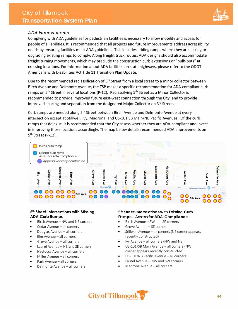
City of Tillamook Transportation System Plan
44
ADA Improvements Complying with ADA guidelines for pedestrian facilities is necessary to allow mobility and access for
people of all abilities. It is recommended that all projects and future improvements address accessibility
needs by ensuring facilities meet ADA guidelines. This includes adding ramps where they are lacking or
upgrading existing ramps to comply. Along freight truck routes, ADA designs should also accommodate
freight turning movements, which may preclude the construction curb extensions or “bulb‐outs” at
crossing locations. For information about ADA facilities on state highways, please refer to the ODOT
Americans with Disabilities Act Title 11 Transition Plan Update.
Due to the recommended reclassification of 5th Street from a local street to a minor collector between
Birch Avenue and Delmonte Avenue, the TSP makes a specific recommendation for ADA‐compliant curb
ramps on 5th Street in several locations (P‐12). Reclassifying 5th Street as a Minor Collector is
recommended to provide improved future east‐west connection through the City, and to provide
improved spacing and separation from the designated Major Collector on 3rd Street.
Curb ramps are needed along 5th Street between Birch Avenue and Delmonte Avenue at every
intersection except at Stillwell, Ivy, Madrona, and US‐101 SB Main/NB Pacific Avenues. Of the curb
ramps that do exist, it is recommended that the City assess whether they are ADA‐compliant and invest
in improving those locations accordingly. The map below details recommended ADA improvements on
5th Street (P‐12).
5th Street Intersections with Missing ADA-Curb Ramps Birch Avenue – NW and NE corners
Cedar Avenue – all corners
Douglas Avenue – all corners
Elm Avenue – all corners
Grove Avenue – all corners
Laurel Avenue – NE and SE corners
Nestucca Avenue – all corners
Miller Avenue – all corners
Park Avenue – all corners
Delmonte Avenue – all corners
5th Street Intersections with Existing Curb Ramps – Assess for ADA-Compliance Birch Avenue – SW and SE corners
Grove Avenue – SE corner
Stillwell Avenue – all corners (NE corner appearsrecently constructed)
Ivy Avenue – all corners (NW and NE)
US‐101/SB Main Avenue – all corners (NWcorner appears recently constructed)
US‐101/NB Pacific Avenue – all corners
Laurel Avenue – NW and SW corners
Madrona Avenue – all corners
City of Tillamook Transportation System Plan
45
FIGURE 12. PEDESTRIAN CROSSING PROJECTS – ARTERIAL AND COLLECTOR NETWORK
City of Tillamook Transportation System Plan
46
TABLE 9. PEDESTRIAN CROSSING PROJECTS – ARTERIAL AND COLLECTOR NETWORK
Corridor Location Description/Justification Need
(Basic/Advanced)
OR‐131/3rd Street and OR‐6 at 1st and 3rd Streets
OR‐131/3rd Street at Ash Avenue
Medical facility on north side of OR‐131 Basic Crossing Improvement
OR‐131/3rd Street at Elm Avenue
Additional marked crossing location on OR‐131
Basic Crossing Improvement
OR‐6/1st Street at Goodspeed Park
Existing marked crossing; multiple lanes of vehicle traffic at this location
Advanced Crossing Improvement
OR‐6/1st Street at Delmonte Avenue
Implement marked crossing and curb bulbouts at Delmonte Avenue
Advanced Crossing Improvement
OR‐6/1st and 3rd Streets at Ocean Place
2003 TSP: Provide a raised island at Ocean Place and 4th and 3rd Streets for a safe pedestrian refuge with marked crosswalks on every approach. Designate Ocean Place between the OR‐6 couplet as northbound only.
Advanced Crossing Improvement
Stillwell Avenue
Stillwell Avenue at Front Street
Hoquarton Waterfront Plan: Enhanced Crossing Improvement Location
Basic Crossing Improvement
Stillwell Avenue at 2nd Avenue
Hoquarton Waterfront Plan: Enhanced Crossing Improvement Location
Basic Crossing Improvement
Stillwell Avenue at 5th Street
Collector street; facilitate safe crossing to nearby school, YMCA and park
Basic Crossing Improvement
Stillwell Avenue at 8th Street
Collector street; facilitate safe crossing to nearby school, YMCA and park
Basic Crossing Improvement
Stillwell Avenue at 10th Street
Collector street; facilitate safe crossing to nearby school, YMCA and park
Basic Crossing Improvement
3rd Street (east of Miller Avenue)
3rd Street at Del Monte Avenue
Crossing to Goodspeed Park Basic Crossing Improvement
Evergreen Drive at 3rd Street
Future traffic forecasts indicate significant increases in vehicle traffic at this location
Basic Crossing Improvement
4th Street
4th Street at Laurel Avenue
Minor collector crossing Basic Crossing Improvement
4th Street at Madrona Avenue
Minor collector crossing Basic Crossing Improvement
9th Street 9th Street at Elm Avenue Improve deficient pedestrian crossing Basic Crossing
Improvement
City of Tillamook Transportation System Plan
47
Corridor Location Description/Justification Need
(Basic/Advanced)
US‐101 NB Main and SB Pacific Avenues
US‐101 Main Ave N at Hadley Road N
No existing marked crossings along US‐101 at this location. Improve crossing environment with an RRFB.
Advanced Crossing Improvement
US‐101 Main Ave N near Makinster Road
Add an RRFB to this existing marked crossing. Advanced Crossing Improvement
at 7th Street Improve deteriorated crossing with marked crossing and signage
Basic Crossing Improvement
at 9th Street Improve deteriorated pedestrian crossing with marked crossing and signage
Basic Crossing Improvement
at 11th Street Improve deteriorated pedestrian crossing with marked crossing, signage, and Rectangular Rapid Flashing Beacon
Advanced Crossing Improvement
Ivy Avenue Ivy Avenue at 2nd Street Hoquarton Waterfront Plan: Enhanced Crossing Improvement Location
Basic Crossing Improvement
Fir Avenue Fir Avenue at 2nd Street Hoquarton Waterfront Plan: Enhanced Crossing Improvement Location
Basic Crossing Improvement
Miller Avenue
Miller Avenue at 4th Street
Improve crossings in vicinity of the mill site. Basic Crossing Improvement
Miller Avenue at 6th Street
Improve crossings in vicinity of the mill site. Basic Crossing Improvement
Miller Avenue at 8th Street
Improve crossings in vicinity of the mill site. Basic Crossing Improvement
Miller Avenue at 11th Street
Improve crossings in vicinity of the mill site. Basic Crossing Improvement
Marolf Loop Road
Marolf Loop Road south of 3rd Street
Future development likely to create need for improved crossings
Basic Crossing Improvement
Marolf Loop Road at Brookfield Drive
Future development likely to create need for improved crossings
Basic Crossing Improvement
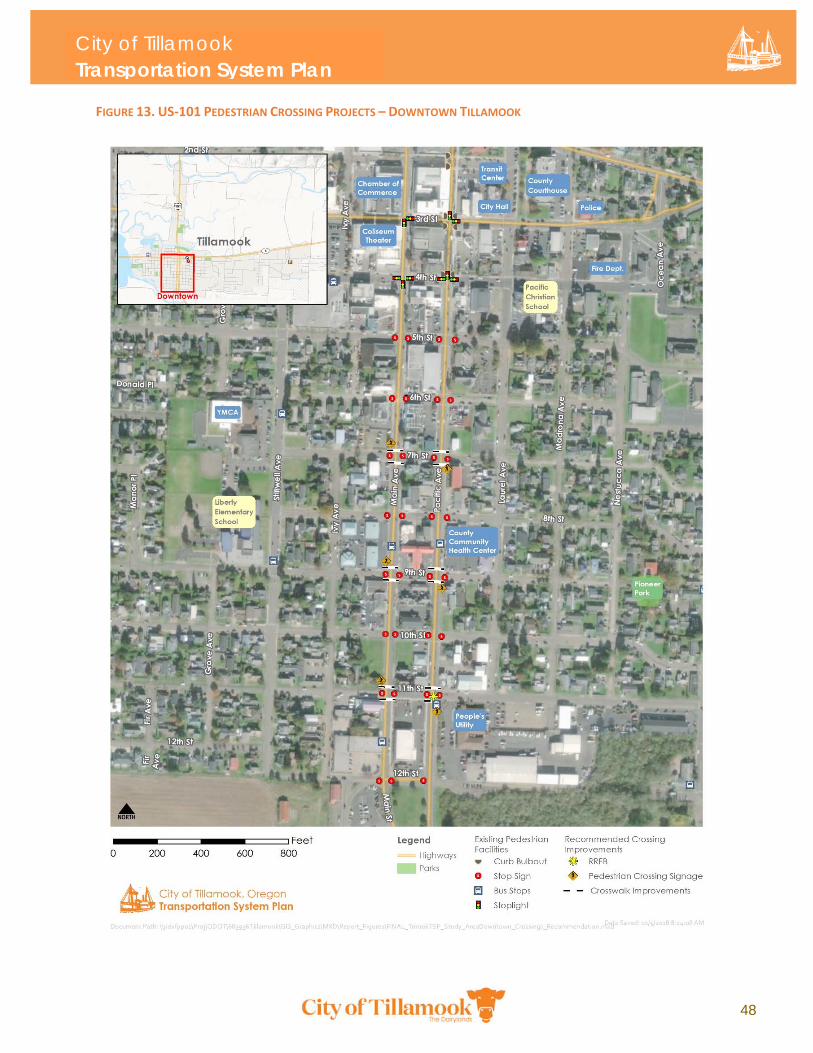
City of Tillamook Transportation System Plan
48
FIGURE 13. US‐101 PEDESTRIAN CROSSING PROJECTS – DOWNTOWN TILLAMOOK
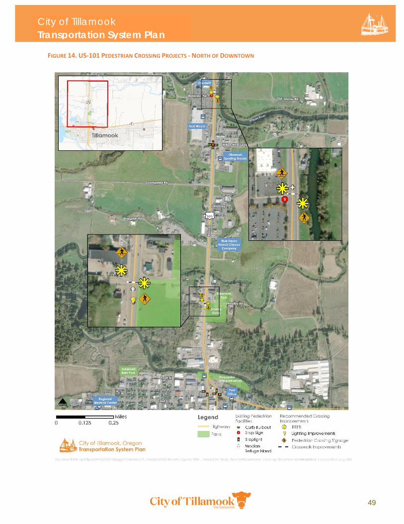
City of Tillamook Transportation System Plan
49
FIGURE 14. US‐101 PEDESTRIAN CROSSING PROJECTS ‐ NORTH OF DOWNTOWN
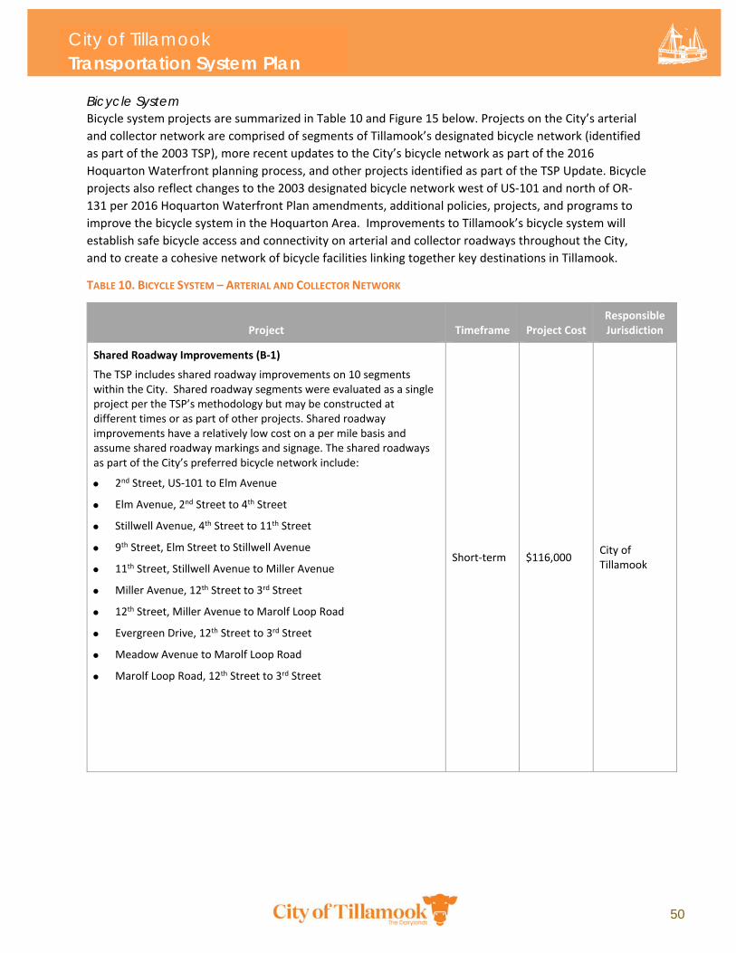
City of Tillamook Transportation System Plan
50
Bicycle System Bicycle system projects are summarized in Table 10 and Figure 15 below. Projects on the City’s arterial
and collector network are comprised of segments of Tillamook’s designated bicycle network (identified
as part of the 2003 TSP), more recent updates to the City’s bicycle network as part of the 2016
Hoquarton Waterfront planning process, and other projects identified as part of the TSP Update. Bicycle
projects also reflect changes to the 2003 designated bicycle network west of US‐101 and north of OR‐
131 per 2016 Hoquarton Waterfront Plan amendments, additional policies, projects, and programs to
improve the bicycle system in the Hoquarton Area. Improvements to Tillamook’s bicycle system will
establish safe bicycle access and connectivity on arterial and collector roadways throughout the City,
and to create a cohesive network of bicycle facilities linking together key destinations in Tillamook.
TABLE 10. BICYCLE SYSTEM – ARTERIAL AND COLLECTOR NETWORK
Project Timeframe Project Cost Responsible Jurisdiction
Shared Roadway Improvements (B‐1)
The TSP includes shared roadway improvements on 10 segments within the City. Shared roadway segments were evaluated as a single project per the TSP’s methodology but may be constructed at different times or as part of other projects. Shared roadway improvements have a relatively low cost on a per mile basis and assume shared roadway markings and signage. The shared roadways as part of the City’s preferred bicycle network include:
2nd Street, US‐101 to Elm Avenue
Elm Avenue, 2nd Street to 4th Street
Stillwell Avenue, 4th Street to 11th Street
9th Street, Elm Street to Stillwell Avenue
11th Street, Stillwell Avenue to Miller Avenue
Miller Avenue, 12th Street to 3rd Street
12th Street, Miller Avenue to Marolf Loop Road
Evergreen Drive, 12th Street to 3rd Street
Meadow Avenue to Marolf Loop Road
Marolf Loop Road, 12th Street to 3rd Street
Short‐term $116,000 City of Tillamook
City of Tillamook Transportation System Plan
51
Project Timeframe Project Cost Responsible Jurisdiction
OR‐131/3rd Street:
Trask River to McCormick Loop Road (B‐2)
Bike Facility: This project provides a continuous on‐street bike facility on OR‐131/3rd Street, creating a needed east‐west neighborhood connection and enhanced bicycle access to Tillamook Regional Medical Center, the Hoquarton Slough multi‐use boardwalk (OS‐2), Tillamook Bay Community College, Tillamook Junior High School, East Elementary School, and Tillamook Seventh Day Adventist School. The project assumes traditional bike lanes.
Long‐term $419,000‐
$638,00027
City of Tillamook in partnership with ODOT
2nd Street – Birch Avenue to Main Avenue (B‐4)
Bike Facility: This project connects to proposed shared roadway improvements on 2nd Street (B‐1) and provides east‐west linkages to the Tillamook Medical Center and proposed Hoquarton Slough off‐street multi‐use boardwalk concept (OS‐2).
Short‐term $15,000 ‐ $25,00027
City of Tillamook
Birch Avenue – OR‐131/3rd Street to 2nd Avenue (B‐5)
Bike Facility: This project connects the proposed bike lanes on 2nd and OR‐131/3rd Streets, providing a north‐south linkage to the proposed bike facilities on 2nd and 3rd Streets.
Short‐term $10,000‐$17,00027
City of Tillamook
Front Street – Main Avenue to Stillwell Avenue (B‐6)
Bike Facility: This project provides an on‐street bike connection between the two proposed off‐street connections near Sue H. Elmore Park and the Hoquarton Slough. This connection also provides east‐west and north‐south access through downtown Tillamook.
Short‐term $10,000‐$16,00027
City of Tillamook
Stillwell Avenue – 4th Street to Front Street (B‐7)
Bike Facility: This project provides an on‐street bicycle lane north of 4th Street, creating a north‐south connection on Stillwell Avenue to Hoquarton Slough. This bike lane also connects to potential off‐street improvements along the southern front of Sue H. Elmore Park and future Salmonberry Trail improvements.
Short‐term $20,000‐$39,00027
City of Tillamook
Bicycle Plaza: Vicinity of 4th Street and Main Avenue
Assumes tubular bike rack for 8‐12 bicycles and overhead shelter. Short‐term
Approx. $8,000 ‐
$12,00028
City of Tillamook
27 The cost range associated with this project reflects a low-build scenario (paint markings, substandard bike lane width) and a full-build scenario (includes estimated cost required to widen shoulders to achieve standard bike lane width). If shoulder widening is not elected for the final project, the substandard bike lanes may need to be deployed in select locations.
28 Based on Staten Island Bicycle Parking Hardware Options Report (1998), published by Staten Island Bicycle Parking at Transit. Unit cost information assumes standard covered bike parking for less than 12 bicycles.
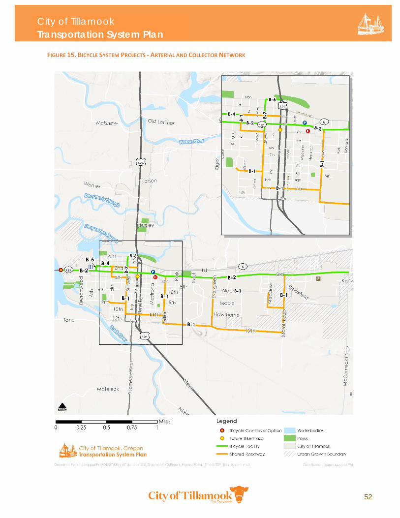
City of Tillamook Transportation System Plan
52
FIGURE 15. BICYCLE SYSTEM PROJECTS ‐ ARTERIAL AND COLLECTOR NETWORK
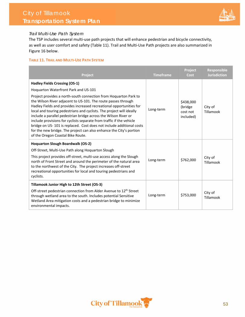
City of Tillamook Transportation System Plan
53
Trail Multi-Use Path System The TSP includes several multi‐use path projects that will enhance pedestrian and bicycle connectivity,
as well as user comfort and safety (Table 11). Trail and Multi‐Use Path projects are also summarized in
Figure 16 below.
TABLE 11. TRAIL AND MULTI‐USE PATH SYSTEM
Project Timeframe Project Cost
Responsible Jurisdiction
Hadley Fields Crossing (OS‐1)
Hoquarton Waterfront Park and US‐101
Project provides a north‐south connection from Hoquarton Park to the Wilson River adjacent to US‐101. The route passes through Hadley Fields and provides increased recreational opportunities for local and touring pedestrians and cyclists. The project will ideally include a parallel pedestrian bridge across the Wilson River or include provisions for cyclists separate from traffic if the vehicle bridge on US‐ 101 is replaced. Cost does not include additional costs for the new bridge. The project can also enhance the City’s portion of the Oregon Coastal Bike Route.
Long‐term
$438,000 (bridge cost not included)
City of Tillamook
Hoquarton Slough Boardwalk (OS‐2)
Off‐Street, Multi‐Use Path along Hoquarton Slough
This project provides off‐street, multi‐use access along the Slough north of Front Street and around the perimeter of the natural area to the northwest of the City. The project increases off‐street recreational opportunities for local and touring pedestrians and cyclists.
Long‐term $762,000 City of Tillamook
Tillamook Junior High to 12th Street (OS‐3)
Off‐street pedestrian connection from Alder Avenue to 12th Street through wetland area to the south. Includes potential Sensitive Wetland Area mitigation costs and a pedestrian bridge to minimize environmental impacts.
Long‐term $753,000 City of Tillamook
City of Tillamook Transportation System Plan
54
Project Timeframe Project Cost
Responsible Jurisdiction
Twelfth Trail – 12th Street Off‐Street Connection (OS‐4)
Tillamook High School to Pacific Avenue
This project proposes an off‐street extension of 12th Street through wetland area to connect Miller Avenue to US‐101 NB Pacific Avenue. Includes potential Sensitive Wetland Area mitigation costs and a pedestrian ramp to minimize environmental impacts.
Long‐term $287,000 City of Tillamook
Salmonberry Trail Improvements (OS‐5)
This project proposes an enhanced off‐street pedestrian/bicycle link along 3rd Street, Miller Avenue, and Pacific Avenue to the planned Salmonberry Trail. Project assumes no wetland impacts or right‐of‐way needed. The project lead is the Port of Tillamook Bay in coordination with the City of Tillamook.
Short‐term $629,00029
City of Tillamook in partnership with Port of Tillamook Bay
29 The cost estimate for Salmonberry Trail Improvements (OS-5) was developed by City of Tillamook staff in 2018.
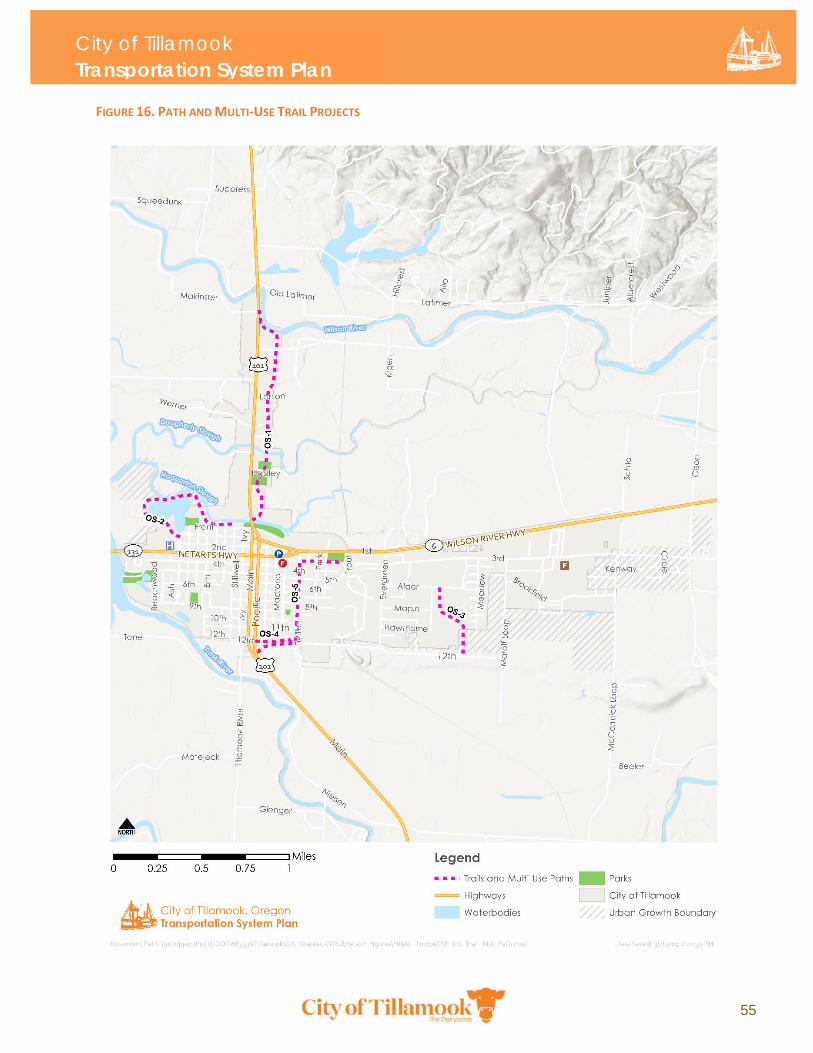
City of Tillamook Transportation System Plan
55
FIGURE 16. PATH AND MULTI‐USE TRAIL PROJECTS
City of Tillamook Transportation System Plan
56
Safe Routes to School The Safe Routes to School (SRTS) National Partnership works to advance safe walking and bicycling to
and from schools to improve the health and wellbeing of all kids.30 With the passage of the 2017 Keep
Oregon Moving Act, the Oregon Legislature has allocated an annual $10 million investment in Oregon’s
SRTS Fund, increasing to $15 million in 2023. Projects to construct or improve bicycle lanes, sidewalks,
reductions in vehicle speeds, and crossings within 1 mile of a public school are eligible to receive state
SRTS funds.
There are seven schools in the City of Tillamook; four are administered by the Tillamook School District
#9, two are private, and the other is the Tillamook Bay Community College.31 Improvements to the
bicycle and pedestrian system within ¼ mile of any of these schools are considered as being within a
school transportation zone. Although these ¼ mile “zones” are not formally designated per SRTS
eligibility guidelines, acknowledgement of the transportation networks near school sites (both private
and public) was a useful construct in determining transportation system needs and solutions for the City
of Tillamook. Given the close distancing of schools, many of these zones clustered to form broader
bicycle and pedestrian networks concentrated in Downtown Tillamook and East Tillamook.
All proposed bike and pedestrian solutions were within 1 mile of a public school and therefore
potentially eligible to receive SRTS funding. SRTS‐eligible projects were assigned a higher priority over all
other projects to promote a safe, convenient, and accessible transportation for students travelling to
and from school on foot or by bike. Figure 17 characterizes the desired transportation networks within
these school transportation zones. Pursuant to ORS 195.115, it is recommended that the City of
Tillamook work with Tillamook County School District #9 to develop a Safe Routes to School Action Plan
or Safe Route to Schools Infrastructure Plan (OAR 737‐025‐0060).
30 Safe Routes to School National Partnership (2018). Our Mission and Vision. https://www.saferoutespartnership.org/about/mission
31 Although college campuses are not traditionally included in Safe Routes to School efforts, improved bicycle and pedestrian connections for Tillamook Bay Community College students who access the TBCC campus are considered and prioritized as part of the TSP Update.
City of Tillamook Transportation System Plan
57
FIGURE 17. SAFE ROUTES TO SCHOOL‐ELIGIBLE BICYCLE AND PEDESTRIAN PROJECTS
City of Tillamook Transportation System Plan
58
3.4 Public Transportation System Plan Public Transportation System Conditions Tillamook County Transportation District (TCTD, or “the Wave”) provides public transportation services
to the City of Tillamook, including deviated fixed‐route bus, demand response and dial‐a‐ride services,
and intercity service to regional connections as far north as Cannon Beach, south to Lincoln City, west to
Pacific City and Oceanside, and east to Portland. TCTD is a member of the Northwest Oregon Transit
Alliance – a coordinated regional transit system called the Northwest Connector comprised of five
county transit providers across northwest Oregon.
Local bus service in Tillamook is comprised of the Tillamook Town Loop, which is shown in Figure 18
below. The Tillamook Town Loop is considered a deviated fixed‐route – a type of demand response
service that has a defined route and stops, although anybody can request a deviation. Wave services to
Cannon Beach, Lincoln City, and Oceanside are also categorized as deviated fixed‐route services.
TCTD meets ADA requirements by providing additional demand response services such as Dial‐A‐Ride
(DAR). Tillamook’s DAR service is a public Dial‐A‐Ride, meaning anybody may use the service. TCTD also
operates a Medicaid Transportation Brokerage called NW Rides. NW Rides is a call center that arranges
Medicaid‐eligible residents rides to their medical appointments. NW Rides coordinates Medicaid
transportation for the Tillamook, Clatsop, and Columbia County regions.
The TCTD Long‐Range Transit Development Plan (LRTDP) estimates that between 2010 and 2040, transit
demand is expected to increase by at least 20 percent. The size of the TCTD fleet is determined by the
service needs. The financial forecast documented in the LRTDP has indicated that TCTD has a capacity to
support up to three new buses. Currently, TCTD operates a fleet of 23 vehicles, comprised of five vehicle
types.
City of Tillamook Transportation System Plan
59
FIGURE 18. TCTD PUBLIC TRANSPORTATION SYSTEM IN TILLAMOOK
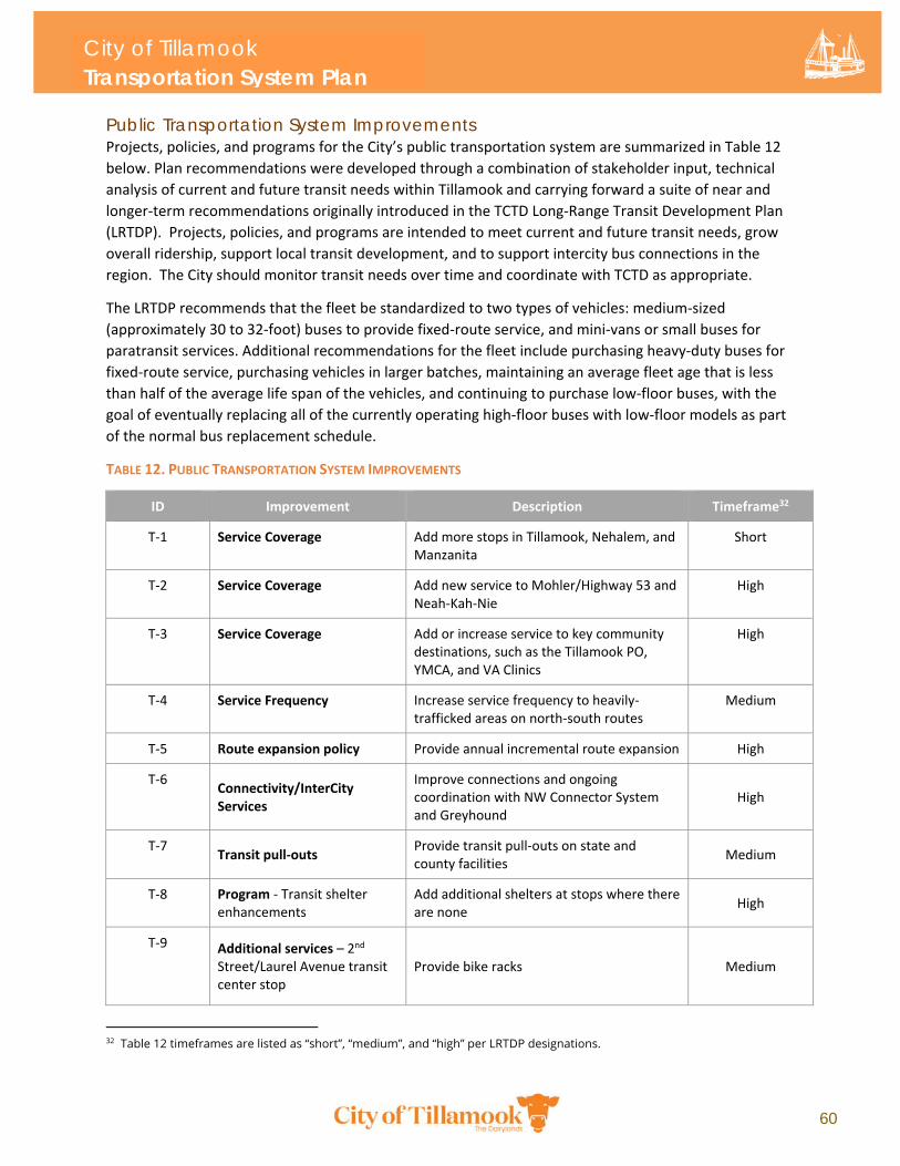
City of Tillamook Transportation System Plan
60
Public Transportation System Improvements Projects, policies, and programs for the City’s public transportation system are summarized in Table 12
below. Plan recommendations were developed through a combination of stakeholder input, technical
analysis of current and future transit needs within Tillamook and carrying forward a suite of near and
longer‐term recommendations originally introduced in the TCTD Long‐Range Transit Development Plan
(LRTDP). Projects, policies, and programs are intended to meet current and future transit needs, grow
overall ridership, support local transit development, and to support intercity bus connections in the
region. The City should monitor transit needs over time and coordinate with TCTD as appropriate.
The LRTDP recommends that the fleet be standardized to two types of vehicles: medium‐sized
(approximately 30 to 32‐foot) buses to provide fixed‐route service, and mini‐vans or small buses for
paratransit services. Additional recommendations for the fleet include purchasing heavy‐duty buses for
fixed‐route service, purchasing vehicles in larger batches, maintaining an average fleet age that is less
than half of the average life span of the vehicles, and continuing to purchase low‐floor buses, with the
goal of eventually replacing all of the currently operating high‐floor buses with low‐floor models as part
of the normal bus replacement schedule.
TABLE 12. PUBLIC TRANSPORTATION SYSTEM IMPROVEMENTS
ID Improvement Description Timeframe32
T‐1 Service Coverage Add more stops in Tillamook, Nehalem, and Manzanita
Short
T‐2 Service Coverage Add new service to Mohler/Highway 53 and Neah‐Kah‐Nie
High
T‐3 Service Coverage Add or increase service to key community destinations, such as the Tillamook PO, YMCA, and VA Clinics
High
T‐4 Service Frequency Increase service frequency to heavily‐trafficked areas on north‐south routes
Medium
T‐5 Route expansion policy Provide annual incremental route expansion High
T‐6 Connectivity/InterCity Services
Improve connections and ongoing coordination with NW Connector System and Greyhound
High
T‐7 Transit pull‐outs
Provide transit pull‐outs on state and county facilities
Medium
T‐8 Program ‐ Transit shelter enhancements
Add additional shelters at stops where there are none
High
T‐9 Additional services – 2nd Street/Laurel Avenue transit center stop
Provide bike racks
Medium
32 Table 12 timeframes are listed as “short”, “medium”, and “high” per LRTDP designations.
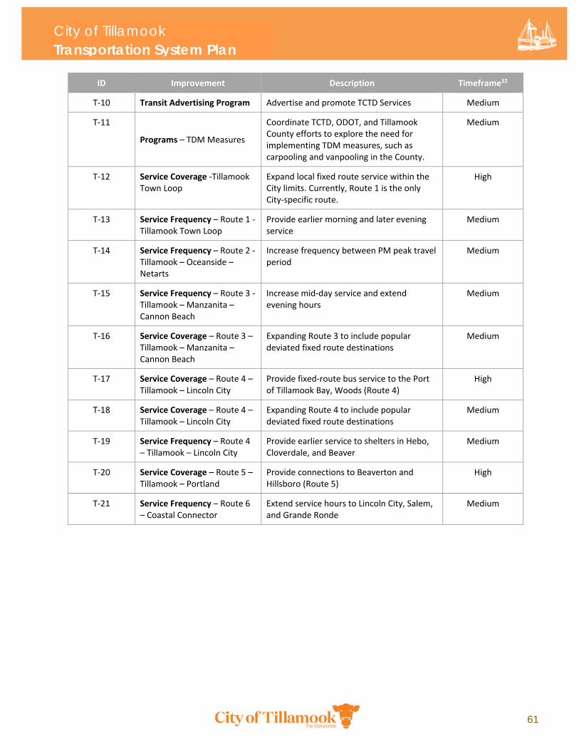
City of Tillamook Transportation System Plan
61
ID Improvement Description Timeframe32
T‐10 Transit Advertising Program Advertise and promote TCTD Services Medium
T‐11
Programs – TDM Measures
Coordinate TCTD, ODOT, and Tillamook County efforts to explore the need for implementing TDM measures, such as carpooling and vanpooling in the County.
Medium
T‐12 Service Coverage ‐Tillamook Town Loop
Expand local fixed route service within the City limits. Currently, Route 1 is the only City‐specific route.
High
T‐13 Service Frequency – Route 1 ‐ Tillamook Town Loop
Provide earlier morning and later evening service
Medium
T‐14 Service Frequency – Route 2 ‐ Tillamook – Oceanside – Netarts
Increase frequency between PM peak travel period
Medium
T‐15 Service Frequency – Route 3 ‐ Tillamook – Manzanita – Cannon Beach
Increase mid‐day service and extend evening hours
Medium
T‐16 Service Coverage – Route 3 – Tillamook – Manzanita – Cannon Beach
Expanding Route 3 to include popular deviated fixed route destinations
Medium
T‐17 Service Coverage – Route 4 – Tillamook – Lincoln City
Provide fixed‐route bus service to the Port of Tillamook Bay, Woods (Route 4)
High
T‐18 Service Coverage – Route 4 – Tillamook – Lincoln City
Expanding Route 4 to include popular deviated fixed route destinations
Medium
T‐19 Service Frequency – Route 4 – Tillamook – Lincoln City
Provide earlier service to shelters in Hebo, Cloverdale, and Beaver
Medium
T‐20 Service Coverage – Route 5 – Tillamook – Portland
Provide connections to Beaverton and Hillsboro (Route 5)
High
T‐21 Service Frequency – Route 6 – Coastal Connector
Extend service hours to Lincoln City, Salem, and Grande Ronde
Medium
City of Tillamook Transportation System Plan
62
3.5 Truck Freight System Plan Truck Freight System Conditions Tillamook has designated various roads in the City as truck routes in addition to the state freight routes
designated in the OHP. Tillamook’s designated truck routes are the backbone for trade and commerce
within the City and provide critical connections between state facilities and major freight destinations in
the City, including TP Freight Lines, Hampton Lumber Company, and industrial businesses on Front
Street. The City’s existing designated freight routes are shown in Figure 19 below.
Truck freight conditions were reviewed and identified based on the following factors:
Connectivity – Is the freight network defined and connected, providing for regional truck trips as well as access to industrial and commercial areas within Tillamook?
Geometrics – Are designated truck routes modernized and built to current standards?
Mobility – Have locations along key truck routes been identified as congestion or mobility issues?
Truck Routes and Connectivity The intent of a truck route is to provide the most efficient transport route for goods and materials that
also minimizes conflicts with other modes, and while providing adequate connections between the state
and local systems. While it is preferred to separate trucks from other modes as much as possible,
conflicts with other modes in some areas (such as downtown) are unavoidable due to the confluence of
land uses and regional highway junctions.
Currently, truck routes generally provide access to the City’s industrial areas. The two primary industrial
areas in the City are the Hampton Lumber Company site (bordered by 3rd Street, Evergreen Drive, and
12th Street) and the downtown industrial area on Front Street and 1st Street. These areas are served by
local freight routes to access the regional highways in Tillamook. A need for an east‐west local truck
route was identified on 12th Street. This local freight route could serve the Hampton Lumber Company
site and nearby farms with large equipment transportation needs. It is important to note that freight
trucks may still need to travel on non‐designated truck routes. Adequate signage for the designated
truck route system could reduce the amount of truck traffic using non‐designated streets.
Truck Route Geometrics Several truck routes do not meet current cross‐section standards for designated truck routes:
US‐101: Hadley Road to Front Street (some of this segment will meet standards after the US‐101/OR‐6 project is completed)
3rd Street: from Schild Road to Olson Road
Birch Avenue: 1st Street to 3rd Street
Wilson River Loop: 3rd Street to OR‐6
Olson Road: 3rd Street to OR‐6
City of Tillamook Transportation System Plan
63
Truck Mobility Traffic mobility is summarized previously in the Roadway System section. None of the study intersection
movements33 located along truck routes are projected to exceed mobility standards by 2040.
Freight System Projects Freight Routes34 TSP freight routes to accommodate safe and efficient freight movement in the City are summarized in
Figure 19 below. Freight routes include US‐101 (south of the downtown core and Main/Pacific couplet)
and OR‐131. As of the writing of this plan, US‐101 and OR‐131 are not classified as freight routes in the
Oregon Highway Plan even though freight trucks currently use these state and regional facilities to
access Tillamook. Freight routes also include improved connection to the east side of town, circulation
to and from the US‐101 couplet, and connections to other key industrial areas around the City.
Truck Access Alternatives to Hampton Lumber Company The Tillamook Transportation Refinement Plan (2006) includes recommended changes to the Hampton
Lumber Company access:
Develop 3rd Street freight access
Site circulation changes to allow 10th Street access and 3rd Street access
33 The northbound left turn movement on Evergreen Drive at 3rd Street exceeds the mobility standard. While 3rd Street is a truck route, the movement from Evergreen Drive is not along the truck route.
34 Further definition around freight routes in Tillamook are pending ongoing discussions between the City and the Oregon Department of Transportation (ODOT).
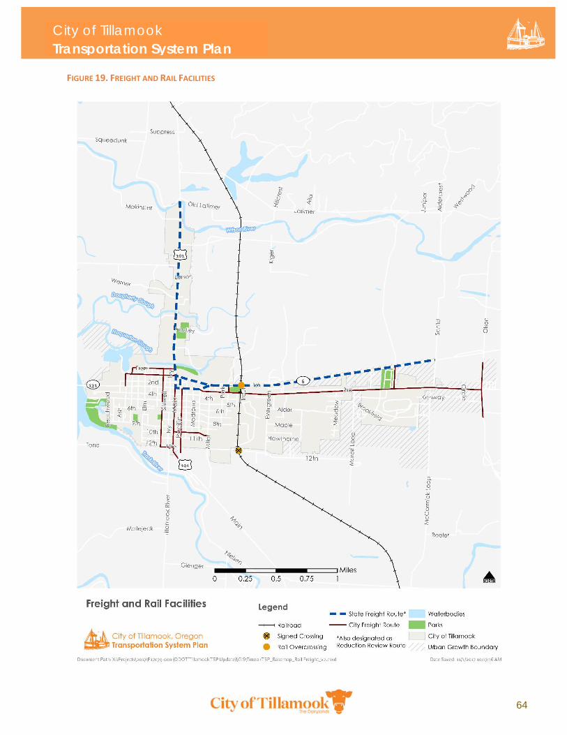
City of Tillamook Transportation System Plan
64
FIGURE 19. FREIGHT AND RAIL FACILITIES
City of Tillamook Transportation System Plan
65
3.6 Rail Plan There is one rail facility in Tillamook. The southern terminus of the rail line is at the Port of Tillamook
Bay industrial site, while the north terminus is in Enright. In Tillamook, the rail line proceeds in the
north‐south direction between Miller Avenue and Evergreen Drive.
The Port of Tillamook Bay, which owns and operates the line, filed for abandonment of the rail line with
the Surface Transportation Board (STB) in May 2016. The Oregon Coast Scenic Railroad currently has
operating rights but does not operate any regular trains through Tillamook. However, they may
periodically operate rail equipment through the area. Additionally, a severe storm in December 2007
badly damaged the rail line, rendering it inoperable as a freight line. Approval has been granted by the
STB to establish interim trail use of the entire line. Future plans include replacing some rail sections with
trails, and in other sections adding trails adjacent to the rail line35.
There is an overcrossing which carries the rail line over OR‐6 just east of Del Monte Avenue. There are
two at‐grade crossings – one at 3rd Street and the other at 12th Street. At the 3rd Street crossing, flashing
lights and an automatic gate warn vehicles of oncoming trains. The 12th Street crossing only has static
railroad signs placed on both sides of the track. At OR‐6, the rail line is grade‐separated above the
roadway, then continues north, east of Tillamook. The designated track speed is 10 miles per hour. The
TSP Update does not include any projects for Tillamook’s rail system and is consistent with the rail plan
adopted by the Port of Tillamook Bay.
Salmonberry Trail The 88‐mile Port of Tillamook Bay rail corridor formerly owned by Southern Pacific running from
Schefflin to the Tillamook Airport once connected the Willamette Valley to the Oregon Coast through
the canyon of the Salmonberry River and the Tillamook State Forest. The Port purchased the right‐of‐
way from Southern Pacific in 1990 and owns the corridor as of the writing of this plan, which is now
known as the Salmonberry Corridor. Early planning by community advocates and regional agencies have
envisioned the corridor as a regional trail between existing recreational trails and parks, educational
opportunities, and heritage sites. The TSP Update recommends an enhanced off‐street
pedestrian/bicycle link between Hoquarton Park and US‐101 to facilitate future connections to the
Salmonberry Trail. A concept for the Salmonberry Trail is still in the very early stages and will likely take
many additional years of planning before it can be considered as a complete regional resource in the
area. Future rail projects should consider potential impacts to the Salmonberry Trail.
3.7 Aviation Plan The Tillamook Airport, owned and operated by the Port of Tillamook Bay, is located south of Tillamook,
outside the City limits adjacent to US‐101. The airport provides services ranging from light passenger
and cargo planes to modern military aircraft, as well as experimental aircraft and airships. Currently,
Tillamook Airport provides no commercial air passenger service, but the airport is suitable for most
private or commercial aircraft. The Portland International Airport, which is located approximately
75 miles east of Tillamook, is the closest commercial air passenger service provider.
35 Per email conversation with Richard Shankle and Robert Melbo at ODOT, Rail and Public Transit Division. October 2017.
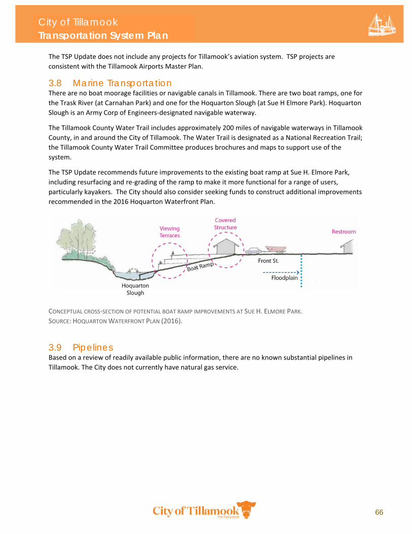
City of Tillamook Transportation System Plan
66
The TSP Update does not include any projects for Tillamook’s aviation system. TSP projects are
consistent with the Tillamook Airports Master Plan.
3.8 Marine Transportation There are no boat moorage facilities or navigable canals in Tillamook. There are two boat ramps, one for
the Trask River (at Carnahan Park) and one for the Hoquarton Slough (at Sue H Elmore Park). Hoquarton
Slough is an Army Corp of Engineers‐designated navigable waterway.
The Tillamook County Water Trail includes approximately 200 miles of navigable waterways in Tillamook
County, in and around the City of Tillamook. The Water Trail is designated as a National Recreation Trail;
the Tillamook County Water Trail Committee produces brochures and maps to support use of the
system.
The TSP Update recommends future improvements to the existing boat ramp at Sue H. Elmore Park,
including resurfacing and re‐grading of the ramp to make it more functional for a range of users,
particularly kayakers. The City should also consider seeking funds to construct additional improvements
recommended in the 2016 Hoquarton Waterfront Plan.
CONCEPTUAL CROSS‐SECTION OF POTENTIAL BOAT RAMP IMPROVEMENTS AT SUE H. ELMORE PARK.
SOURCE: HOQUARTON WATERFRONT PLAN (2016).
3.9 Pipelines Based on a review of readily available public information, there are no known substantial pipelines in
Tillamook. The City does not currently have natural gas service.
4.1 Funding Sources 4.2 Funding Gap and
Recommendations
Chapter 4: Implementation
62
Chapter 4: Implementation This section describes the funding and finance plan to carry out the TSP projects, including a summary of the City’s existing and historical sources of transportation funding, as well as a funding and finance recommendation to be carried out by City leadership.
4.1 Funding Sources The City’s primary sources of transportation revenues includes the state gas tax, local fuel tax, and,
recently, ODOT Special City Allotment (SCA) Grants and general fund revenues.36 The TSP Update
included a review of these and other funding sources to identify potential funding pathways that the
City could pursue for implementing TSP projects. A thorough review of external funding opportunities
was critical to the developing of an implementation strategy for TSP projects as local funds are currently
limited. Furthermore, the TSP is a long‐term plan which includes a range of short, medium, and long‐
term projects, policies and programs. Implementation timeframes for TSP projects will influence how
these projects are funded and prioritized over the 2040 planning horizon. Note that the TSP Update is
not a fiscally constrained plan. Table 13 outlines transportation revenue from various sources from fiscal
years 2012 to 2017.
Share of State Gas Tax The City’s allotment of state gas tax revenue has been relatively stable over the last five years except for
fiscal year 2014‐15, during which the allotment increased by approximately 48 percent over the
previous fiscal year. City revenue from state gas tax distributions are likely to remain steady or grow
slightly, in real dollar terms, depending on action taken at the state level to increase transportation
revenues.
ODOT Special City Allotment Grant The City was granted ODOT SCA funds in fiscal years 2012‐13, 2015‐16, and 2016‐17. The SCA program is
an annual allocation of state funds for local transportation projects in cities with 5,000 or fewer
residents. Eligible projects must be on City streets that are not part of a county road or the state
highway system. Additionally, SCA funds can only be used on streets that are “inadequate for the
capacity they serve or are in a condition detrimental to safety” (ORS 366.805). Some agencies use SCA
funds as a local match for larger projects that also meet the intent of SCA. Individual project funding
under the SCA program is limited to $50,000 per project. Cities can request an advance of up to one half
($25,000). The City of Tillamook may not remain eligible for SCA funds in the future given the population
thresholds of the program. As of the 2018, the City had a population of 4,920.37
36 Note: General Fund revenues are not allocated for transportation unless they include traffic enforcement by Tillamook Police.
37 Portland State University (2019). Population Research Center. Annual Population Estimates, Certified Population Estimates, July 1, 2018. https://www.pdx.edu/prc/population-reports-estimates
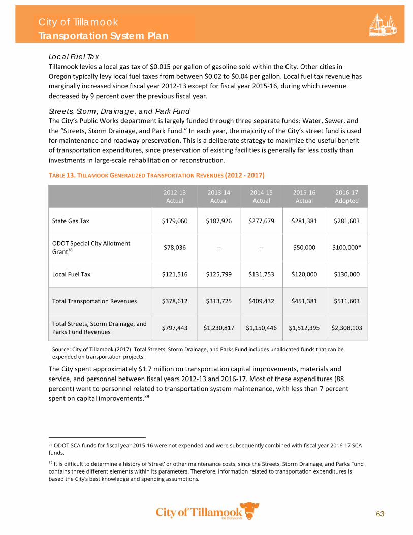
City of Tillamook Transportation System Plan
63
Local Fuel Tax Tillamook levies a local gas tax of $0.015 per gallon of gasoline sold within the City. Other cities in
Oregon typically levy local fuel taxes from between $0.02 to $0.04 per gallon. Local fuel tax revenue has
marginally increased since fiscal year 2012‐13 except for fiscal year 2015‐16, during which revenue
decreased by 9 percent over the previous fiscal year.
Streets, Storm, Drainage, and Park Fund The City’s Public Works department is largely funded through three separate funds: Water, Sewer, and
the “Streets, Storm Drainage, and Park Fund.” In each year, the majority of the City’s street fund is used
for maintenance and roadway preservation. This is a deliberate strategy to maximize the useful benefit
of transportation expenditures, since preservation of existing facilities is generally far less costly than
investments in large‐scale rehabilitation or reconstruction.
TABLE 13. TILLAMOOK GENERALIZED TRANSPORTATION REVENUES (2012 ‐ 2017)
2012‐13 Actual
2013‐14 Actual
2014‐15 Actual
2015‐16 Actual
2016‐17 Adopted
State Gas Tax $179,060 $187,926 $277,679 $281,381 $281,603
ODOT Special City Allotment Grant38
$78,036 ‐‐ ‐‐ $50,000 $100,000*
Local Fuel Tax $121,516 $125,799 $131,753 $120,000 $130,000
Total Transportation Revenues $378,612 $313,725 $409,432 $451,381 $511,603
Total Streets, Storm Drainage, and Parks Fund Revenues
$797,443 $1,230,817 $1,150,446 $1,512,395 $2,308,103
Source: City of Tillamook (2017). Total Streets, Storm Drainage, and Parks Fund includes unallocated funds that can be expended on transportation projects.
The City spent approximately $1.7 million on transportation capital improvements, materials and
service, and personnel between fiscal years 2012‐13 and 2016‐17. Most of these expenditures (88
percent) went to personnel related to transportation system maintenance, with less than 7 percent
spent on capital improvements.39
38 ODOT SCA funds for fiscal year 2015-16 were not expended and were subsequently combined with fiscal year 2016-17 SCA funds.
39 It is difficult to determine a history of ‘street’ or other maintenance costs, since the Streets, Storm Drainage, and Parks Fund contains three different elements within its parameters. Therefore, information related to transportation expenditures is based the City’s best knowledge and spending assumptions.
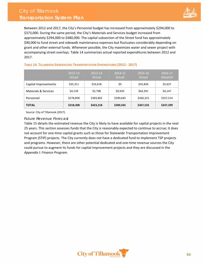
City of Tillamook Transportation System Plan
64
Between 2012 and 2017, the City’s Personnel budget has increased from approximately $294,000 to
$373,000. During the same period, the City’s Materials and Services budget increased from
approximately $294,000 to $480,000. The capital subsection of the Street fund has approximately
$90,000 to fund street and sidewalk maintenance expenses but fluctuates considerably depending on
grant and other external funds. Whenever possible, the City maximizes water and sewer project with
accompanying street overlays. Table 14 summarizes actual reported expenditures between 2012 and
2017.
TABLE 14. TILLAMOOK GENERALIZED TRANSPORTATION EXPENDITURES (2012 ‐ 2017)
2012‐13 Actual
2013‐14 Actual
2014‐15 Actual
2015‐16 Actual
2016‐17 Adopted
Capital Improvements $35,311 $33,618 $0 $42,826 $5,637
Materials & Services $4,139 $5,798 $9,920 $64,391 $4,147
Personnel $278,858 $383,802 $290,645 $260,315 $327,514
TOTAL $318,308 $423,218 $300,565 $367,532 $337,299
Source: City of Tillamook (2017).
Future Revenue Forecast Table 15 details the estimated revenue the City is likely to have available for capital projects in the next
25 years. This section assesses funds that the City is reasonably expected to continue to accrue; it does
not account for one‐time capital grants such as those for Statewide Transportation Improvement
Program (STIP) projects. The City currently does not have a dedicated fund to implement TSP projects
and programs. However, there are other potential dedicated and one‐time revenue sources the City
could pursue to augment its funds for capital improvement projects and they are discussed in the
Appendix I: Finance Program.
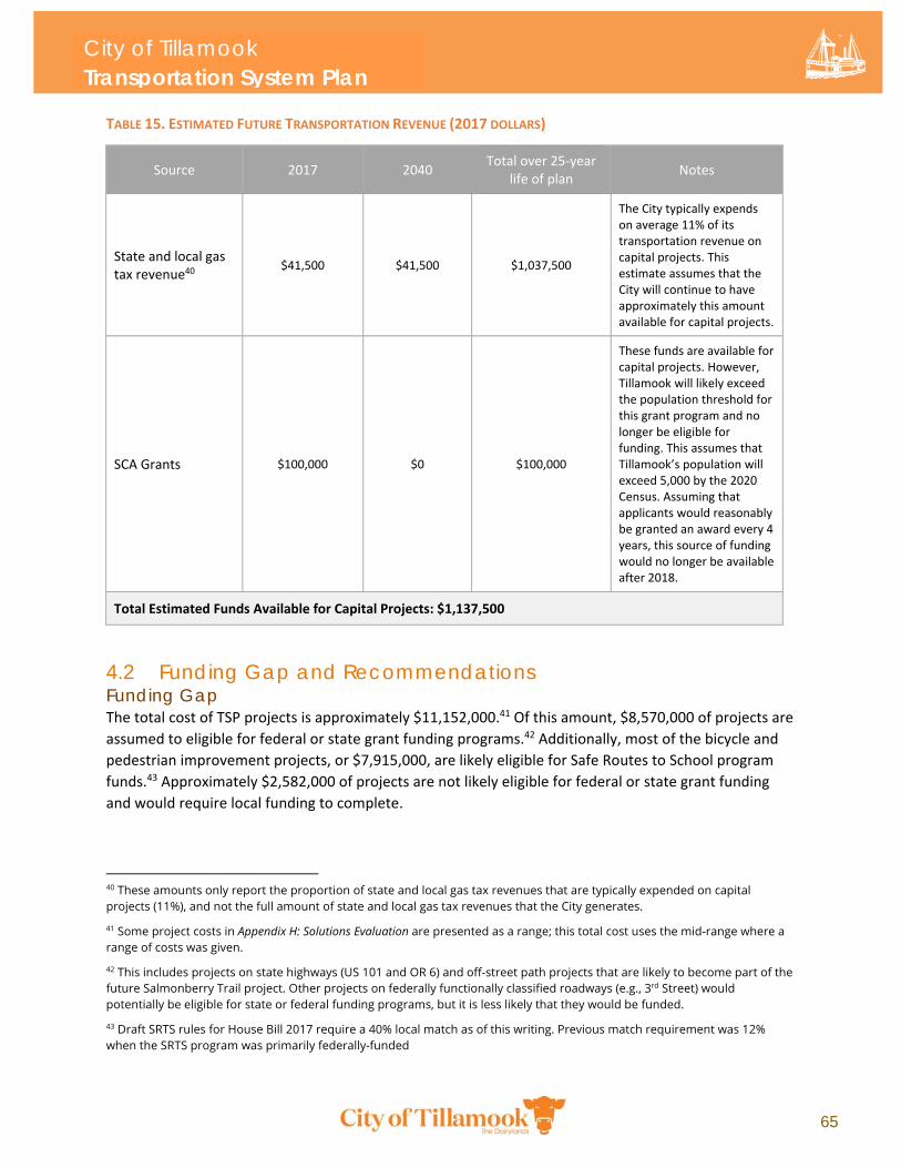
City of Tillamook Transportation System Plan
65
TABLE 15. ESTIMATED FUTURE TRANSPORTATION REVENUE (2017 DOLLARS)
Source 2017 2040 Total over 25‐year
life of plan Notes
State and local gas tax revenue40
$41,500 $41,500 $1,037,500
The City typically expends on average 11% of its transportation revenue on capital projects. This estimate assumes that the City will continue to have approximately this amount available for capital projects.
SCA Grants $100,000 $0 $100,000
These funds are available for capital projects. However, Tillamook will likely exceed the population threshold for this grant program and no longer be eligible for funding. This assumes that Tillamook’s population will exceed 5,000 by the 2020 Census. Assuming that applicants would reasonably be granted an award every 4 years, this source of funding would no longer be available after 2018.
Total Estimated Funds Available for Capital Projects: $1,137,500
4.2 Funding Gap and Recommendations Funding Gap The total cost of TSP projects is approximately $11,152,000.41 Of this amount, $8,570,000 of projects are
assumed to eligible for federal or state grant funding programs.42 Additionally, most of the bicycle and
pedestrian improvement projects, or $7,915,000, are likely eligible for Safe Routes to School program
funds.43 Approximately $2,582,000 of projects are not likely eligible for federal or state grant funding
and would require local funding to complete.
40 These amounts only report the proportion of state and local gas tax revenues that are typically expended on capital projects (11%), and not the full amount of state and local gas tax revenues that the City generates.
41 Some project costs in Appendix H: Solutions Evaluation are presented as a range; this total cost uses the mid-range where a range of costs was given.
42 This includes projects on state highways (US 101 and OR 6) and off-street path projects that are likely to become part of the future Salmonberry Trail project. Other projects on federally functionally classified roadways (e.g., 3rd Street) would potentially be eligible for state or federal funding programs, but it is less likely that they would be funded.
43 Draft SRTS rules for House Bill 2017 require a 40% local match as of this writing. Previous match requirement was 12% when the SRTS program was primarily federally-funded
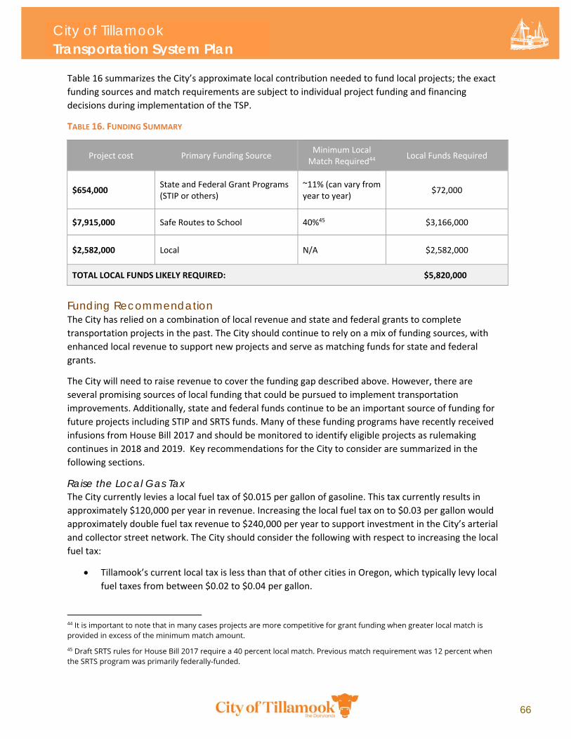
City of Tillamook Transportation System Plan
66
Table 16 summarizes the City’s approximate local contribution needed to fund local projects; the exact
funding sources and match requirements are subject to individual project funding and financing
decisions during implementation of the TSP.
TABLE 16. FUNDING SUMMARY
Project cost Primary Funding Source Minimum Local Match Required44
Local Funds Required
$654,000 State and Federal Grant Programs (STIP or others)
~11% (can vary from year to year)
$72,000
$7,915,000 Safe Routes to School 40%45 $3,166,000
$2,582,000 Local N/A $2,582,000
TOTAL LOCAL FUNDS LIKELY REQUIRED: $5,820,000
Funding Recommendation The City has relied on a combination of local revenue and state and federal grants to complete
transportation projects in the past. The City should continue to rely on a mix of funding sources, with
enhanced local revenue to support new projects and serve as matching funds for state and federal
grants.
The City will need to raise revenue to cover the funding gap described above. However, there are
several promising sources of local funding that could be pursued to implement transportation
improvements. Additionally, state and federal funds continue to be an important source of funding for
future projects including STIP and SRTS funds. Many of these funding programs have recently received
infusions from House Bill 2017 and should be monitored to identify eligible projects as rulemaking
continues in 2018 and 2019. Key recommendations for the City to consider are summarized in the
following sections.
Raise the Local Gas Tax The City currently levies a local fuel tax of $0.015 per gallon of gasoline. This tax currently results in
approximately $120,000 per year in revenue. Increasing the local fuel tax on to $0.03 per gallon would
approximately double fuel tax revenue to $240,000 per year to support investment in the City’s arterial
and collector street network. The City should consider the following with respect to increasing the local
fuel tax:
Tillamook’s current local tax is less than that of other cities in Oregon, which typically levy local
fuel taxes from between $0.02 to $0.04 per gallon.
44 It is important to note that in many cases projects are more competitive for grant funding when greater local match is provided in excess of the minimum match amount.
45 Draft SRTS rules for House Bill 2017 require a 40 percent local match. Previous match requirement was 12 percent when the SRTS program was primarily federally-funded.
City of Tillamook Transportation System Plan
67
A $0.015 increase in the fuel tax is unlikely to significantly increase transportation costs for
residents of Tillamook; the increase would cost the average driver approximately an additional
$0.15 per fill‐up or $7.20 per year.46
Local gas tax would also be paid by visitors and those travelling through Tillamook, whereas
other forms of local revenue (like transportation maintenance fees) are typically sourced
exclusively from residents and employers.
Average fuel economy is increasing, and the number of alternative fuel vehicles is growing,
meaning that the gas tax generally will become a less effective revenue instrument in the future.
Revenues would likely decline over the planning period. This revenue decline could be mitigated
by future increases in the local gas tax rate.
Prior efforts to raise the local gas tax in Tillamook have not been successful. The City would need
to adopt a strategy for public acceptance of an increased local gas tax. Tactics that have been
successful in other communities include clearly defining the projects that increased revenue
would support; articulating how the increase would affect the cost of transportation; and
showing the potential transportation benefits to the community.
Implement System Development Charges System Development Charges (SDCs) are fees levied on developers during the permitting and approval
process for constructing new development. Tillamook does not currently assess transportation SDCs or
other forms of utility fees. Several coastal communities in Oregon do charge SDCs. The City could
leverage this type of revenue to support local street investments. The City should consider the following
with respect to implementing SDCs:
SDCs are commonly employed by jurisdictions. They primarily impact developers. However,
depending on the magnitude of the fee, SDCs may increase the costs of developing, though SDCs
typically represent a very small fraction of the costs of development and would likely have a
negligible effect on construction costs.
SDC revenue is not reliable from year to year and is completely dependent on the amount and
type of development occurring. During economic downturns, SDC revenue may decline
substantially.
It is difficult to estimate SDC revenue, as revenue is dependent on the type of fee assessment;
development of a SDC methodology and fee structure is beyond the scope of this TSP Update.
However, at a hypothetical fee of $2,000 per new residential unit, Tillamook could expect to
generate about $754,000 over the life of the plan in residential SDC revenue, based on a
forecasted 377 additional households by 2040. For non‐residential, assuming approximately
75,000 square feet of new non‐residential development47 and a low average fee of $2,000 per
1,000 square feet, the City could generate approximately $140,000 additional in non‐residential
fees.
46 Based on a ten gallon fill-up and an average of 12,000 miles driven per year and 25 miles per gallon average fuel economy of the current fleet.
47 Based on a conservative assumption of approximately 100 square feet per new anticipated employee. Approximately 700 new employees/jobs are forecast in Tillamook by the planning horizon year.
City of TillamookTransportation System Plan

Top Related