


Languages
Pages
Legal


The Day of the Drones - Airports and Unmanned Aircraft Systems Part 2
April 27, 2021

Heather HasperDHJ Alaska
Airport PlannerAir Traffic ControllerDynamic Aerial Imagery
InstructorAirspace CoordinatorRemote UAV Part 107 PilotCommercial Instrument
Rated Pilot
Moderator Headshot

Today’s Speakers
Chris Fernando, QS-2
Glady Singh, AkitaBox
Jason Terreri, Syracuse Hancock International Airport
Presenting
ACRP Report 212: Airports and Unmanned Aircraft Systems, Volume 2: Incorporating UAS into Airport Infrastructure—
Planning Guidebook, and Volume 3: Potential Use of UAS by Airport Operators

ACRP Research Report 212
Airports and UnmannedAircraft Systems
Planning for UAS and Applications by Airports
Chris Fernando, Principal and Aviation LeadQuantitative Scientific Solutions

Chris FernandoPrincipal Investigator
Principal and Aviation Lead at QS-2
Principal, Hovecon
Co-host of No U-Turn Podcast
Principal Investigator, ACRP 03-42, Airports and UAS
PI and PM for multiple UAS and UAM research efforts for FAA and NASA
BS, Aviation Management, Florida Institute of Technology

ACRP Report 212 Oversight Panel
Heather Hasper, DHJ Alaska, San Jose, CA (Chair)Kerry L. Ahearn, Transportation Research Board, Washington, DCStephen K. Cusick, Florida Institute of Technology, Melbourne, FLAdam Durrin, Independent Consultant, Greenwich, NYAmit Lagu, Independent Consultant, Sunnyvale, CAGaël Le Bris, WSP USA, Raleigh, NCMichael R. Scott, Reno-Stead Airport, Reno, NVJeremy Worrall, Alaska DOT and Public Facilities, Fairbanks, AKMichael DiPilato, FAA LiaisonJared Raymond, FAA LiaisonJustin Barkowski, American Association of Airport Executives LiaisonTracy Lamb, Association for Unmanned Vehicle Systems International LiaisonChristopher J. Oswald, Airports Council International—North America LiaisonChristine Gerencher, TRB Liaison

Agenda
ACRP 03-42 Team and Scope
Research Areas
Planning for UAS at Airports
UAS Applications by Airports
Demonstrations of UAS at Airports
Highlights of IPP/BEYOND

Research Team and Project Scope
Value: $1MPOP: 22 MonthsPublished: July 2020
Stakeholder Engagement Airspace Management Airport Planning Safety Management Systems Legal and Regulatory UAS Operators and
Technology
BOOZALLEN
NO
VE
L (D
BE
)HO
GAN
LO
VE
LLS
PrincipalInvestigator
AIRPORT PARTNERS
ACRP 03-42
RESEARCH TEAM

Research Areas
Volume I – Managing UAS Operations in the Vicinity of an Airport
Volume II – Engaging Stakeholders in UAS & Incorporating UAS into Airport Infrastructure andPlanning
Volume III – Potential Use of UAS by AirportOperators

Research Scope

Research and Initiatives Supporting UAS Integration Efforts
TRB ACRP – Integrating UAS into Airports
FAA UAS Integration Pilot Program (IPP) and BEYOND
FAA UAS Test Sites
Northeast UAS Airspace Integration Research Alliance, Inc (NUAIR) in New York
UAS corridor in Grand Folks, North Dakota
FlyOhio and 33 Smart Mobility Corridor in Ohio
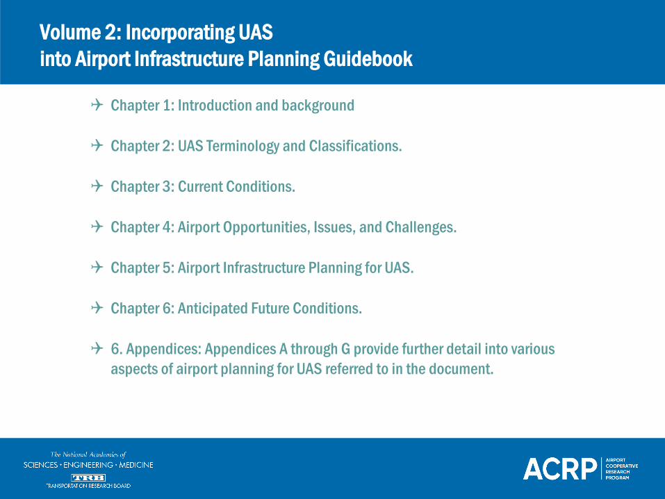
Volume 2: Incorporating UASinto Airport Infrastructure Planning Guidebook
Chapter 1: Introduction and background
Chapter 2: UAS Terminology and Classifications.
Chapter 3: Current Conditions.
Chapter 4: Airport Opportunities, Issues, and Challenges.
Chapter 5: Airport Infrastructure Planning for UAS.
Chapter 6: Anticipated Future Conditions.
6. Appendices: Appendices A through G provide further detail into various aspects of airport planning for UAS referred to in the document.

UAS Planning for Airports
UAS Infrastructure Planning at Airports
Eastern Oregon Regional Airport (PDT) Master Plan (October 2018) is the most robust example of recent UAS infrastructure planning
The Airport Master Plan for the Silver Springs Airport (SPZ) in Nevada included limited reference to UAS
Drone Port Planning
The Eldorado Droneport and the USA Drone Port are designed to facilitate UAS testing, research, and training.
The USA Drone Port or National Unmanned Robotic Research and Development Center is located near Hazard, Kentucky

Potential Use Cases for Airports
• Construction Monitoring• Capturing of time-lapse photos and video• Safety monitoring• Lighting
• Public Safety Assessments• Perimeter Monitoring
• People, Vehicles, Land, Wildlife• Emergency Response• Weather Condition Assessment• Security alerting and patrols
• Infrastructure and Asset Management
• Pavement/structure Inspections• VOR/NDB Inspection• ATC tower Inspection• Roof and HVAC inspections• Land surveying and mapping• Monitoring tree and grass growth
• Operations Support• Remote Tower• Identify Aircraft/UAS• Land side traffic Monitoring of Incidents
• Potential Tenant Use-Cases• Aircraft and hangar Inspections• R&D testing of new technologies• Education and training
• Additional Airport Use-Cases• Community Outreach
(Documenting/Showcasing)• Inventory Management• Augment Air Traffic: ATC tower blind spots• Tracking movement of Vehicles• Airside Dining Delivery Service• Airside Luggage Transportation• Surface Condition Monitoring

3D Runway survey orthomosaic using DroneDeploy
Pix4D software used to program UAS for aerial mapping
Airport Construction SurveysPerimeter Monitoring and Wildlife
Management
UAS used in perimeter monitoring and blind spot capturing
UAS used to herd birds away from airports
UAS for Airport Applications
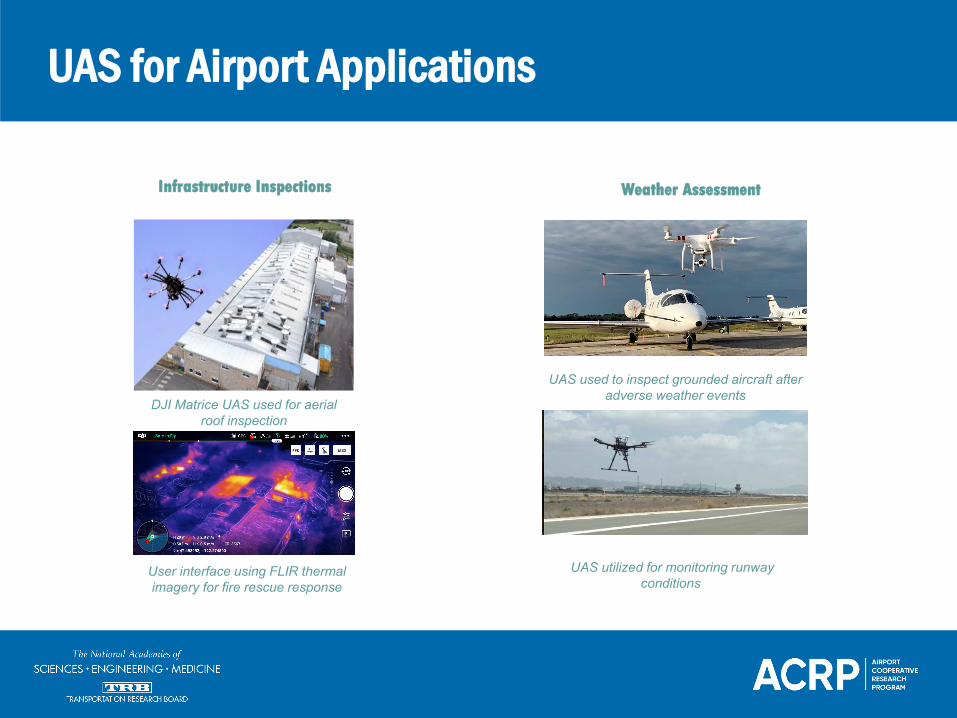
Infrastructure Inspections
Emergency Response and Security
DJI Matrice UAS used for aerial roof inspection
User interface using FLIR thermal imagery for fire rescue response
UAS for Airport Applications
Weather Assessment
UAS used to inspect grounded aircraft after adverse weather events
UAS utilized for monitoring runway conditions

OBJECTIVES OF THEDEMONSTRATION• Demonstrate operation of sUAS within
controlled airspace• Establish best practices for communication
between operators and ATCT• Aerial drone data capture
• Compare traditional pavement management methodology with drone survey data and operations
• Use captured data to develop models for virtual reality and machine intelligence (VR/MI) applications
Field Demonstration at FTG

OBJECTIVES OF THEDEMONSTRATION• Demonstrate operation of sUAS within
uncontrolled airspace
• Operation of two drone operators concurrently with GA traffic utilizing communications best practices
• Aerial drone data capture of wildlife, pavement, and infrastructure facilities
• Develop methods to post process data for use in VR/MI applications
• Test sUAS services during nighttime operations
Field Demonstration at JNX

OBJECTIVES OF THEDEMONSTRATION• Demonstrate operation of sUAS with active
GA operations
• Aerial drone data capture of pavement conditions, and infrastructure facilities (ATCT, hangars, drainage)
• Demonstrate the use of tethered drones for lighting of areas for security and emergency response
• Test sUAS services during nighttime operations
Field Demonstration at SEF

Rapidly-evolving and expanding capabilities of drone platforms and sensors have resulted in increasing numbers of applications by operators for package delivery, infrastructure inspections, and emergency response.
• Security and aircraft inspections by FedEx/MEM
• Medical package deliveries by Zipline, UPS, and Matternet
• Food and coffee delivery by Walmart with FlyTrex and Causey Aviation
• Airborne support to police in Chula Vista
IPP/BEYOND UAS Operations
Photo courtesy FedEx

Thank You
Chris FernandoE: [email protected]
Link to Research Publications:https://apps.trb.org/cmsfeed/TRBNetProjectDisplay.asp?ProjectID=4240
Airports and UAS, is Published as Report 212Volume 1: Managing and Engaging Stakeholders on UAS in the Vicinity of AirportsVolume 2: Incorporating UAS into Airport InfrastructureVolume 3: Potential Use of UAS by Airport Operators
Research under ACRP Project 03-42 was led by Booz Allen Hamilton in association with Embry-Riddle Aeronautical University, Hogan Lovells, Kimley-Horn and Associates, Novel Engineering, Toltz, King, Duvall, Anderson, and Associates, Vanasse Hangen Brustlin, Inc., and Astrid Aviation and Aerospace. These guidance documents identify airport-specific infrastructure and facilities needs to support UAS and describe field demonstrations to test various use cases for potential uses of UAS by airport operators.
Day of the Drones- Part Two
Asset and Facility Management with UAS(and related technology solutions for Airports and beyond)
Glady Singh
AkitaBox, Inc.
27 April, 2021

Glady Singh
Infrastructure and UAS Technology Consultant
GM, Federal Solutions and Innovation, AkitaBox
Technology and Innovation Chair, SAME Facility
Asset Management Community of Interest
(SAME FAM COI)
Diversity Equity and Inclusion Program Lead-
AkitaBox
GM, Federal Solutions, PrecisionHawk (former)
Senior Associate, Booz Allen Hamilton (former)
Change Management Practitioner, Georgetown
University
Brownie Girl Scouts Troop Leader

Agenda
UAS Innovation Focus To Date (To Support Government)
Potential UAS Applications Across Asset Lifecycle
Getting Airborne- Approval Coordination for On Airport UAS Ops
SE2020 Project Overview/ Example Planning Detail
Example Innovation in Action- UAS Applications
Broader Remote-Sensing Applications

UAS Innovation Focus to DateEfforts designed to support federal Government
Broaden awareness of UAS technology trends to inform and support the
Government’s efforts with UAS technology adoption
Elevate confidence on adoption via pilot projects demonstrating technology
in action without imposing undue mission risk
Evaluate available COTs platforms to help ensure they are cyber-sound and
secure, developing tailored risk mitigation with proposed applications
Ensure compliance with government policies and regulation, recommending
enabling policies based on demonstrated research
Boost acquisition confidence evaluating technology procurement options
and program support models based on requirements
Beyond UAS data capture, accelerate data and analysis workflows with AI
and visualization to support across the infrastructure lifecycle (vs. traditional
inspection and management approaches)

Potential UAS Applications for AirportsAcross the Infrastructure Lifecycle

UAS On/Near Airport Approval CoordinationFAA Safety Management System Safety Risk Management (SRM)
BOOZ ALLEN
NO
VE
L (D
BE
)
HO
GA
N
LOV
ELL
SPrincipal
Investigator
AIRPORT PARTNERS
• The FAA continues to work to integrate small UAS (Part 107) operations into the airport environment through the development of a national on-airport document change proposal (DCP) to evaluate proposed changes in the NAS
• In parallel, FAA AJI facilitates garnering approval to conduct on airport UAS operations through the Safety Risk Management (SRM) Panel; focused on evaluating proposed change in the NAS using a framework to identify potential hazards of concern, assess severity and impact of risk and appropriate risk controls
• FAA SRM Panel reviewed our detailed Site Survey Plan and 2-3 day interactive discussion to review detailed documentation of proposed operations and accompanying mitigations
• Two conducted SRM panels to date (CLT and GSO) and gained SRM Panel confidence of our intended operations has us on path to approval given the controls and mitigations being employed to conduct safe operations
Project Team
SRM Participants: Change Proponent, Facilitator,
Panel (voting) Members, SMEs, Observers

Flight Team/Site Survey Plan ComponentsSeasoned Team and Documentation to Support UAS Operations
Key Aspects in Site Survey Plan
Flight Parameters
▪ Flight patterns, Geofencing,
Landing/Take off Zones
Survey Equipment Descriptions
▪ Platform
▪ Data Storage Platform
Site Survey Plan Description
Operations and Risk Mitigations
▪ Personnel, Flight Execution
▪ Hazards
▪ Communications / Radio Operations
▪ Go/No Go Criteria
Data Management
▪ Data Sources
▪ Data Specifications

FAA SE2020 Task Order Pilot ProjectBooz Allen Hamilton: UAS Operations/Infrastructure Inspections

Example: UAS Flight Operations On/Near AirportUAS Demonstration at SNS and OAR Airport
Flight Parameters ASR Tower: UAS RGB Visual Data Capture
Team started project with uncontrolled and Class D airspace
operations; successfully completed 29 flights across 4 days at SNS
and OAR to capture RCLR, VOR, Glide Slope and ATCT assets
Vertical and orbit flight patterns with Nadir shots of the top of the
asset where permissible
Average flight time: 20-40 min
5-6m away from structure
Mitigations:
Equipment outage requested/granted for ASR, (for enhanced
safety from potential power emittance)
Visual Observers
Ground Control Station
Sterile Cockpit with take-off/landing zone marked with cones
Evaluated and changed take off locations to maintain VLOS
and navigate safely around guy wires
RCLR Tower: UAS RGB Visual Data Capture

Flight Operations and SafetyStrong Communication and Safety Protocol
• Flight operations to be conducted in accordance with 14
CFR Part 107. The team complies with all Certificate of
Waiver/Authorization (COA) stipulations in addition to any
tower instructions for reporting airport position and
intentions at towered airports.
• If any safety/flight issues arise during operations, the RPIC
will immediately recall the aircraft or discontinue
operations until resolved. If the sUAS needs to be
grounded, UAS is prompted to achieve a specific safe
altitude and come straight down to the launch site.
The RPIC maintains final responsibility for safe flight and
the UAS launch decision. The Airfield Control Tower is the
approving entity authorizing flight within controlled
airspace; team adheres to any coordination requirements
provided by the Airfield Control Tower.
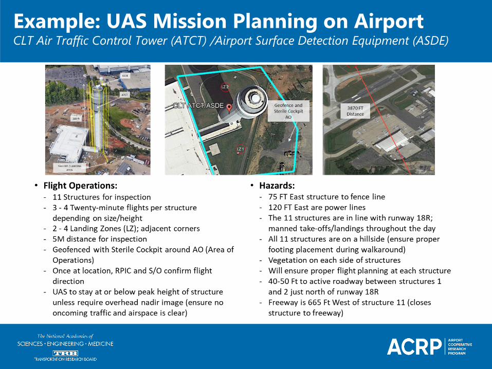
Example: UAS Mission Planning on AirportCLT Air Traffic Control Tower (ATCT) /Airport Surface Detection Equipment (ASDE)

DEMONSTRATED CAPABILITIES
• Demonstrate operation of sUAS with antenna farm equipment outage for enhanced safety (RF max 10 watts)
• Preprogrammed flight (grid) capture with COTs UAS dual visual/thermal camera
• Stitched orthomosaic and AI-powered inventory and identification of roof system equipment with measurements
• AI-powered roof condition assessment from captured imagery detecting roof anomalies and degradation; re-inspect for changes
• Auto-generated roof report to memorialize roof assembly inventory and assessment to validate investment planning for operations and maintenance and recapitalization
• Work orders and repairs with assembly cost data integrated from RS Means
Example: UAS Roof Inspection - TRACON FacilityVisual and Thermal Imagery with Detailed Roof Inspection Report

DEMONSTRATED CAPABILITES
Example: UAS Pavement Inspection VA CampusWest LA VA Medical Center Campus
SERIOUS
VERY POOR
POOR
Drone imagery with AI to autonomously assess pavement condition
▪ Automated USACE Pavement Condition Index algorithms
▪ Effectively provided increased accuracy and detailed assessment compared to traditional inspection method
▪ 100% condition baseline for 25% less time and resources
Airport Benefit:
▪ Reduced Runway Closure/Site Time
▪ Detect Crack/Spalling Anomalies
▪ Quicker/Better Data Outputs

Broader Remote-Sensing ApplicationsVehicle-based LiDAR/Visual Pavement Inspection
Vehicle-mounted LiDAR and video capture; lane and aerial view with distress colorized and linework
Mounted View Riegl VMX-250
VMX-250-CS6 SYSTEM (VEHICLE –BASED LIDAR/VISUAL CAPTURE)
• 250 lb., mounted system operated by two-person vehicle LiDAR team
• LiDAR data post processed in appropriate coordinates with static GPS base station and on-board GPS and IMU data
• Both elevation and intensity measures are recorded:
• Elevation data for pavement distress analysis
• Intensity data to render a detailed ‘picture’ of road surface to identify paint markings, lane widths, etc.
• Condition data to spatially identify rutting, corrugation, potholes, bumps and depressions

Broader Remote-Sensing ApplicationsMobile scanning equipment to create detailed 3D models (digital twin)
GROUND SCANNING SYSTEM:
NavVis VLX• Wearable, 3D unit equipped with 2 LiDAR scanners and 4
360-degree cameras• Corresponding data analysis tool: Bluebeam Revu iPad
application
NavVis VLX Touch
Technology Viewer (above)
and Mobile LiDAR Scanner
(left)
Paracosm PX-80
Handheld LiDAR
Navis VLX
Data Capture
in Action

Focusing on the Future
H. Jason Terreri, IAP, A.A.E.Executive Director
Town HallTuesday, November 19, 2019
How UAS Opportunities Benefit SYR
H. Jason Terreri, IAP, A.A.E.Executive Director
Syracuse Regional Airport Authority

Regional Approach to UAS
• NY Governor Andrew Cuomo laid out the state’s plan to make Central New York and the Mohawk Valley a global center for UAS testing and innovation
• Griffiss Test site established in Rome, NY and managed by NUAIR (Northeast UAS Airspace Integration Research)
• A City Center Innovation Hub with a $12.5M development grant to include an inside drone testing facility in the Syracuse Technology Garden
• GENIUS NY – a $3M annual business accelerator competition focused on UAS startups. Companies come from around the world to participate

UAS Community
• UAS Business Community:• Lockheed Martin, L3-Harris, AIS, Saab, SRC and Gryphon Sensors
• Education Partnerships:• Syracuse University:
• Thales (UTM)• NUAIR Aerospace engineering internships
• Workforce Development:• Monroe Community College - the first New York institution to help educate
a new generation of drone pilots and technicians• Onondaga Community College - degree tracks in Electromechanical Drone
Technology and Geospatial Science & Technology

50 Mile Drone Corridor
The corridor will allow the government and private companies to test UAS beyond visual lines of site
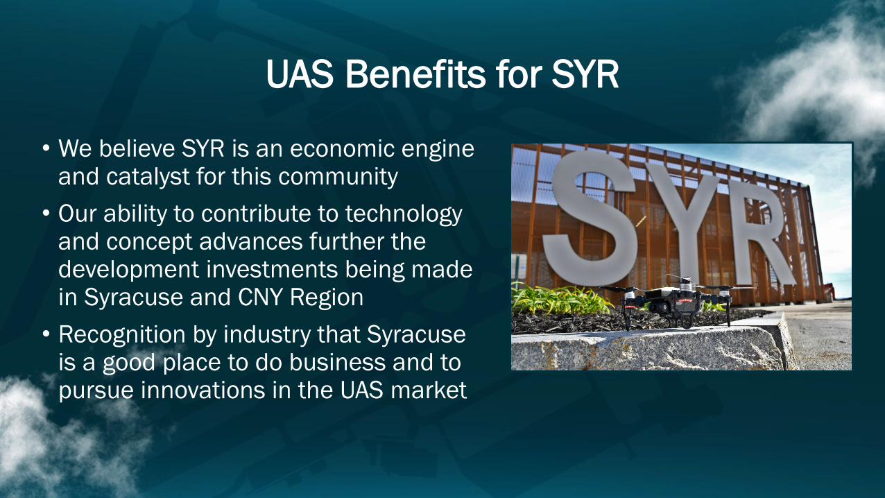
UAS Benefits for SYR
• We believe SYR is an economic engine and catalyst for this community
• Our ability to contribute to technology and concept advances further the development investments being made in Syracuse and CNY Region
• Recognition by industry that Syracuse is a good place to do business and to pursue innovations in the UAS market

UAS Integration at SYR
• SYR selected to host the FAA’s Airport Unmanned Aircraft System(s) (UAS) Detection and Mitigation Research Program
• 24-month Commitment• FAA will evaluate at least 10 different technologies

SYR Operations
Syracuse is the only commercial airport in the US to have integrated UAS operations with commercial traffic

UAS Test Flight – ILS Calibration• Partnered with Thales to test ILS
“flight check” using a drone• Operating during runway closure
related to pavement improvement• 6 flights to test:
• Course Alignment & fluctuation• Localizer width• Glide Slope width• Glide Path angle and fluctuation

Flight Operation Area• All maneuvers, equipment, home locations remain in the shaded blue zone

Planning for the future
• Received FAA Approval to include UAS infrastructure planning in our Master Plan update (expected start 2Q2021)
• UAS needs now included in all our planning efforts

Questions?
Top Related