


Languages
Pages
Legal


NationalAeronauticsandSpaceAdministration
JetPropulsionLaboratoryCaliforniaInstituteofTechnologyPasadena,California
Taking on Big Ocean Data Science
Thomas Huang
Jet Propulsion LaboratoryCalifornia Institute of Technology
4800 Oak Grove DrivePasadena, CA 91109-8099
United States of AmericaCL#16-4603© 2016 California Institute of Technology. Government sponsorship acknowledged.Reference herein to any specific commercial product, process, or service by trade name, trademark,manufacturer, or otherwise, does not constitute or imply its endorsements by the United StatesGovernment or the Jet Propulsion Laboratory, California Institute of Technology. IMDIS2016,Gdansk,Poland
NationalAeronauticsandSpaceAdministration
JetPropulsionLaboratoryCaliforniaInstituteofTechnologyPasadena,California

NationalAeronauticsandSpaceAdministration
JetPropulsionLaboratoryCaliforniaInstituteofTechnologyPasadena,California
Data Scientist @NASA/JPL• Project Technologist for the NASA’s Physical Oceanography Distributed
Active Archive Center (PO.DAAC) – http://podaac.jpl.nasa.gov
• Architect for the NASA Sea Level Change Portal –https://sealevel.nasa.gov
• Principal Investigator / Co-Investigator in several NASA-funded Big Data Analytic Projects
• OceanXtremes: Oceanographic Data-Intensive Anomaly Detection and Analysis Portal – https://oceanxtremes.jpl.nasa.gov
• Distributed Oceanographic Matchup Service (DOMS) –https://doms.jpl.nasa.gov
• Mining and Utilizing Dataset Relevancy from Oceanographic Datasets (MUDROD)
• Enhanced Quality Screening for Earth Science Data –https://vqss.jpl.nasa.gov
• NEXUS - Big Data Analytic on the Cloud
• Architect for Tactical Data Science Framework for Naval Research
• Ontologist for the Semantic Web for Earth and Environmental Terminology (SWEET) Ontologies – http://sweet.jpl.nasa.gov
• Chair for The Federation of Earth Science Information Partners (ESIP) Cloud Computing Cluster
• Chair/Co-Chair for the NASA Earth Science Data System Working Groups
THUANG/JPL IMDIS2016,Gdansk,Poland

NationalAeronauticsandSpaceAdministration
JetPropulsionLaboratoryCaliforniaInstituteofTechnologyPasadena,California
NASA’S PO.DAAC• The NASA Physical Oceanography Distributed Active Archive
Center (PO.DAAC) at Jet Propulsion Laboratory is an element of the Earth Observing System Data and Information System (EOSDIS). The EOSDIS provides science data to a wide communities of user for NASA’s Science Mission Directorate.
• Archives and distributes data relevant to the physical state of the ocean
• The mission of the PO.DAAC is to PRESERVE NASA’s ocean and climate data and make these universally ACCESSIBLE and MEANINGFUL.
THUANG/JPL IMDIS2016,Gdansk,Poland
http://podaac.jpl.nasa.gov
NationalAeronauticsandSpaceAdministration
JetPropulsionLaboratoryCaliforniaInstituteofTechnologyPasadena,California
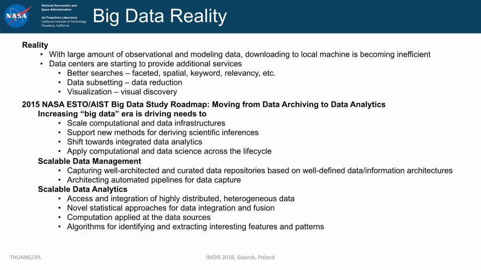
Big Data RealityReality
• With large amount of observational and modeling data, downloading to local machine is becoming inefficient• Data centers are starting to provide additional services
• Better searches – faceted, spatial, keyword, relevancy, etc.• Data subsetting – data reduction• Visualization – visual discovery
2015 NASA ESTO/AIST Big Data Study Roadmap: Moving from Data Archiving to Data AnalyticsIncreasing “big data” era is driving needs to
• Scale computational and data infrastructures• Support new methods for deriving scientific inferences• Shift towards integrated data analytics • Apply computational and data science across the lifecycle
Scalable Data Management• Capturing well-architected and curated data repositories based on well-defined data/information architectures• Architecting automated pipelines for data capture
Scalable Data Analytics• Access and integration of highly distributed, heterogeneous data• Novel statistical approaches for data integration and fusion• Computation applied at the data sources• Algorithms for identifying and extracting interesting features and patterns
THUANG/JPL IMDIS2016,Gdansk,Poland

NationalAeronauticsandSpaceAdministration
JetPropulsionLaboratoryCaliforniaInstituteofTechnologyPasadena,California
FactsMoving/copying science data (and managing copies) is more expensive than computation.Hardware & software do not yet make science data analysis easy at terabyte scales.Current analytics are mostly I/O bound.Next generation - “advanced” analytics will be compute bound (simulations, distributed linear algebra). Efficiency matters. Current files formats are good for data archival, NOT for data analysis
THUANG/JPL IMDIS2016,Gdansk,Poland
“The scientific file-formats of HDF, NetCDF, and FITS can represent tabular data but they provide minimal tools for searching and analyzing tabular data… Performing this filter-then-analyze, data analysis on large datasets with conventional procedural tools runs slower and slower as data volumes increase.”
-- Jim Gray, Scientific Data Management in the Coming Decade

NationalAeronauticsandSpaceAdministration
JetPropulsionLaboratoryCaliforniaInstituteofTechnologyPasadena,California
Traditional Data Analysis
IMDIS2016,Gdansk,Poland
Search Download Compute
• Depending on the data volume (size and number of files)• It could take many hours of download – (e.g. 10yr of observational data could yield thousands of files)• It could take many hours of computation• It requires expensive local computing resource (CPU + RAM + Storage)• After result is produced, purge downloaded files
Observation• Traditional methods for data analysis (time-series, distribution, climatology generation) can’t scale to handle large
volume, high-resolution data. They perform poorly• Performance suffers when involve large files and/or large collection of files• A high-performance data analysis solution must be free from file I/O bottleneck
THUANG/JPL

NationalAeronauticsandSpaceAdministration
JetPropulsionLaboratoryCaliforniaInstituteofTechnologyPasadena,California
NASA’s Upcoming Big Data Mission: Surface Water and Ocean Topography (SWOT)
THUANG/JPL IMDIS2016,Gdansk,Poland
• Data Volume:• 17PB of original data• 6 PB of reprocessed data
• Total of about 23PB for a nominal 3-year mission
• Add roughly 450TB/month for any mission extension
Oceanography:Characterizetheoceanmesoscale andsub-mesoscale circulationatspatialresolutionsof10kmandgreater.
Hydrology:Toprovideaglobalinventoryofallterrestrialwaterbodieswhosesurfaceareaexceeds(250m)2 (lakes,reservoirs,wetlands)andriverswhosewidthexceeds100m(requirement)(50mgoal)(rivers).
• Tomeasuretheglobalstoragechangeinfreshwaterbodiesatsub-monthly,seasonal,andannualtimescales.
• Toestimatetheglobalchangeinriverdischargeatsub-monthly,seasonal,andannualtimescales.
Nadir interf. channels
Main Interf. Left swath
Main Interf. Right swath
LaunchesAprilof2021https://swot.jpl.nasa.gov

NationalAeronauticsandSpaceAdministration
JetPropulsionLaboratoryCaliforniaInstituteofTechnologyPasadena,California
THUANG/JPL IMDIS2016,Gdansk,Poland
The Silver Bullet?CloudComputing
Moore’sLawiscomingtoanendduetophysicallimitsofCMOS“thenumberoftransistorscanputonamicrochipdoubleseveryyearorso.”
CloudComputingprovidesanelasticinfrastructuralapproachtoBigData

NationalAeronauticsandSpaceAdministration
JetPropulsionLaboratoryCaliforniaInstituteofTechnologyPasadena,California
But… How Do We Get There?
THUANG/JPL IMDIS2016,Gdansk,Poland
Here There

NationalAeronauticsandSpaceAdministration
JetPropulsionLaboratoryCaliforniaInstituteofTechnologyPasadena,California
NEXUS Deep Data Analytics: One-Minute Summary
NEXUS is an emerging technology developed at JPL• Open Source: https://github.com/dataplumber/nexus• A Cloud-based/Cluster-based data platform that performs scalable handling
of observational parameters analysis designed to scale horizontally by• Leveraging high-performance indexed, temporal, and geospatial search
solution• Breaks data products into small chunks and stores them in a Cloud-based
data store
Data Volumes Exploding• SWOT mission is coming• File I/O is slow
Scalable Store & Compute is Available• NoSQL cluster databases• Parallel compute, in-memory map-reduce• Bring Compute to Highly-Accessible Data (using Hybrid Cloud)
Pre-Chunk and Summarize Key Variables• Easy statistics instantly (milliseconds)• Harder statistics on-demand (in seconds)• Visualize original data (layers) on a map quickly
IMDIS2016,Gdansk,PolandTHUANG/JPL 10
EDGE
Geospatial Metadata
Repository
Data Aggregation Service
Search andAccess Metadata Analytic
NEXUSDeep Data Platform
DataManagement
Data Access and Distribution
Workflow Data Analysis
Builtwithopensourcetechnologies• ApacheSolr• ApacheCassandra• ApacheSpark/PySpark• ApacheMesos/YARN• ApacheKafka• ApacheZookeeper• Tornado• SpringXD• EDGE

NationalAeronauticsandSpaceAdministration
JetPropulsionLaboratoryCaliforniaInstituteofTechnologyPasadena,California
Analytics & Summarization StackUsing Two Scalable Database Technologies
30-Year Time Series of archival HDF & netCDF files (daily or per orbit)
Fast &Scalable
Display Variables on Map Latitude-Time Hovmoller Plot Aggregate Statistics
Cassandra DB Cluster & Spark In-MemoryParallel Compute!
Chunk Chunk Chunk
Chunk Chunk Chunk
Chunk Chunk Chunk
…
SMAP MODIS GRHSST JASON
MetaData
MetaData
MetaData
MetaData …
Solr DB Cluster
Metadata (JSON): Dataset and granule metadata, Spatial Bounding Box & Summary Statistics
Subset Variables & Chunk Spatially
Slow File I/O
Each file contains many high-resolution geolocated arrays
CustomAnalytics
IMDIS2016,Gdansk,PolandTHUANG/JPL 11

NationalAeronauticsandSpaceAdministration
JetPropulsionLaboratoryCaliforniaInstituteofTechnologyPasadena,California
Deep Data Computing Environment (DDCE)• ETL System – Ingest and
stage data• Deep Data Processors –
metadata, statistics, and tiles• Index and Data Catalog –
horizontal-scale geospatial search and tile retrieval
• Analytic Platform – Spark-based domain-specific analytics
• Data Access – tile and collection-based data access
• Cloud Platform – portal and custom VMs
CreditJPL:T.Huang,B.Wilson,G.Chang,E.Armstrong,T.Chin
AIST-14:OceanXtremes
IMDIS2016,Gdansk,PolandTHUANG/JPL 12
NEXUS: The Deep Data Platform
Workflow Automation Horizontal-Scale Data Analysis Environment
Deep Data Processors
Index and Data
Catalog
Data Access
ETL System
Private Cloud
Analytic Platform
ETL System Deep Data Processors
Hadoop
Index and Data Catalog Analytic Platform
Manager Manager Inventory Security SigEvent Search
ZooKeeper ZooKeeperZooKeeper
Manager
Handler Handler Handler
IngestPool
IngestPool
WorkerPool
WorkerPool
File & ProductServices
Job Tracking Services
Business Logics
Applications
HORIZON Data Management and Workflow Framework
Ingest Ingest Ingest
ProductSubscriber
ProductSubscriber
Staging
NoS
QL
Index
Alg Alg Alg
TaskScheduler
Task threads
Block manager
RDD Objects DAG Scheduler Task Scheduler Executor
DAG TaskSet Task
Alg
Alg
Alg
Alg
WebPortal

NationalAeronauticsandSpaceAdministration
JetPropulsionLaboratoryCaliforniaInstituteofTechnologyPasadena,California
Using Apache Spark and Cassandra• Apache Spark
• In-Memory Map-Reduce framework• Datasets partitioned across a compute cluster by key• Resilient Distributed Dataset (RDD)
• Fault-tolerant, parallel data structures• Intermediate results persisted in memory• User controls the partitioning to optimize data
placement• Rich set of operators on RDD’s: Map, Filter, GroupByKey, ReduceByKey, etc.
• Computation is implicit (Lazy) until answers needed• Uses YARN/Mesos
• Apache Cassandra• Horizontal-scale NoSQL database• Constant-time writes regardless of the size of data
set grows• No-single-point of failure architecture
THUANG/JPL IMDIS2016,Gdansk,Poland

NationalAeronauticsandSpaceAdministration
JetPropulsionLaboratoryCaliforniaInstituteofTechnologyPasadena,California
NEXUS Real Time Analysis
THUANG/JPL IMDIS2016,Gdansk,Poland

NationalAeronauticsandSpaceAdministration
JetPropulsionLaboratoryCaliforniaInstituteofTechnologyPasadena,California
The Notebook• /capabilities: list of capabilities
• /chunks: list data chunks by location, time, and datasets
• /correlationMap: Correlation Map
• /datainbounds: Matchup operation to fetch values from dataset within geographic bounds
• /datapoint: Matchup operation to fetch value at lat/lon point
• /dailydifferenceaverage: Daily difference average
• /latitudeTimeHofMoeller: Latitude Time Hovmoeller
• /list: list available datasets
• /longitudeLatitudeMap: Longitude Latitude Map
• /longitudeTimeHofMoeller: Longitude Time Hovmoeller
• /stats: Statistics (standard deviation, count, min/max, time, mean)
THUANG/JPL IMDIS2016,Gdansk,Poland
Interact with NEXUS using Jupyter Notebook

NationalAeronauticsandSpaceAdministration
JetPropulsionLaboratoryCaliforniaInstituteofTechnologyPasadena,California
NEXUS 2.0 Performance Challenge
The Challenge: Show that NEXUS performs 2X or greater speed improvement compare to Giovanni – Sponsored by NASA/ESDIS• Dataset: TRMM Daily Precipitation (TRMM 3B42 Daily V7), 18 years, 6574 granule files, ~26GB• Algorithms
• Area Averaged Time Series• Global Time Averaged Map• Correlation Map
• Giovanni – web application for researchers to analyze NASA’s gridded data.• Backed by the popular NCO (NetCDF Operator) library, highly optimized C/C++ library
• NEXUS• Apache Solr for spatial searches, metadata, and pre-computed statistics• Apache Cassandra for clustered data storage where granule data is partitioned into tiles• Apache Spark for data analytic platform
THUANG/JPL IMDIS2016,Gdansk,Poland 16

NationalAeronauticsandSpaceAdministration
JetPropulsionLaboratoryCaliforniaInstituteofTechnologyPasadena,California
Performance StatisticsAll performed on Apache Spark cluster with 16-way parallel
THUANG/JPL IMDIS2016,Gdansk,Poland
Giovanni NEXUS: 3B42 NEXUS: 3B42RT Giovanni NEXUS: 3B42 NEXUS: 3B42RT Giovanni NEXUS: 3B42 + RT
Giovanni:overanhourNEXUS:alittleover2min
~30Xfaster
Giovanni:about3minNEXUS:1min~3Xfaster
Giovanni:about13minNEXUS:2min~7Xfaster

NationalAeronauticsandSpaceAdministration
JetPropulsionLaboratoryCaliforniaInstituteofTechnologyPasadena,California
NASA Sea Level Change PortalGoals• Provide scientists and the
general public with a “one-stop” source for current sea level change information and data
• Provide interactive tools for accessing and viewing regional data
• Provide virtual dashboard for sea level indicators
• Provide latest news, quarterly report, and publications
• Provide ongoing updates through a suite of editorial products
• Content articles• Multimedia
THUANG/JPL IMDIS2016,Gdansk,Poland
Features• Featured news• Sea level indicators• Understanding sea level
• Causes• Observations• Projections• Adaptation
• Data search• Data Analysis Tool• Ice Sheet Simulation and Modeling Tool• Multimedia• Sea level news• Scientist interviews• Publications• Commentary• Featured multimedia• Subscription for newsletter
https://sealevel.nasa.gov

NationalAeronauticsandSpaceAdministration
JetPropulsionLaboratoryCaliforniaInstituteofTechnologyPasadena,California
On-The-Fly Analysis for Sea Level Rise Research
THUANG/JPL IMDIS2016,Gdansk,Poland 19
• Visualizations – WMTS – tiled imagery webserivce
• Time Series• Data Comparison• Latitude/Time Hofmoeller• Etc.
SeaLevelChange- DataAnalysisTool

NationalAeronauticsandSpaceAdministration
JetPropulsionLaboratoryCaliforniaInstituteofTechnologyPasadena,California
Ocean AnomaliesIdentifying observations which do not conform to an expected
pattern in a dataset or time series.
THUANG/JPL IMDIS2016,Gdansk,Poland

NationalAeronauticsandSpaceAdministration
JetPropulsionLaboratoryCaliforniaInstituteofTechnologyPasadena,California
OceanXtremes – Data-Intensive Anomaly Detection System
• Funded by the NASA Advanced Information System Technology program
• Current and future oceanographic missions and our research communities present us with challenges to rapidly identify features and anomalies in increasingly complex and voluminous observations
• Goals• Provide one-stop portal registry of
ocean anomalies• Provide on-the-fly analysis and
mining on observational data
• Typically this is a two-stage procedure1. Determine a long-term/periodic
mean (“climatology”)2. Deviations from the mean are
searched. Step 1 could be omitted in cases where a climatology data set already exists.
THUANG/JPL IMDIS2016,Gdansk,Poland
XtremesAnalyzer
XtremesVisualizer
Xtremes Explorer
NEXUS
OGCVisualization
Solution
XtremesIngester
XtremesClimatology Xtremes
Processor
ObservationalArchive
XtremesSpeaker
Subscriber
OceamXtremes SystemArchitectureCredit:T.Huang,E.Armstrong,G.Chang,T.Chin,B.Wilson

NationalAeronauticsandSpaceAdministration
JetPropulsionLaboratoryCaliforniaInstituteofTechnologyPasadena,California
Xtremes Explorer: Daily Anomaly
THUANG/JPL IMDIS2016,Gdansk,Poland
Aug02,2012 Aug02,2013
Aug02,2014 Aug02,2015
NationalAeronauticsandSpaceAdministration
JetPropulsionLaboratoryCaliforniaInstituteofTechnologyPasadena,California
MatchupReconciliation of satellite and in-situ datasets
THUANG/JPL IMDIS2016,Gdansk,Poland

NationalAeronauticsandSpaceAdministration
JetPropulsionLaboratoryCaliforniaInstituteofTechnologyPasadena,California
Distributed Oceanographic Matchup Service (DOMS)
• Funded by the NASA Advanced Information System Technology program
• A distributed data service (a.k.a DOMS) to match satellite and in situ marine observations to support platform comparisons, cross-calibration, validation, and quality control
• Use Cases• Satellite Cal/Val and algorithm development• Decision support
• Planning field campaigns• Real-time operational activities
• Scientific investigation• Process studies• Model assimilation services• User friendly interface to support student research
• Alternate matching• Satellite to satellite• Satellite/in situ to model
THUANG/JPL IMDIS2016,Gdansk,Poland
AtlantisHealySouthern SurveyorDavid Star JordanKnorrHenry B. BigelowLawrence M. GouldMiller Freeman

NationalAeronauticsandSpaceAdministration
JetPropulsionLaboratoryCaliforniaInstituteofTechnologyPasadena,California
DOMS Data• In-Situ
• Shipboard Automated Meteorological and Oceanographic System (SAMOS) initiative provides high-quality underway data from research vessels.
• Hosted at Florida State University’s Center for Ocean-Atmospheric Prediction Studies (COAPS), Tallahassee, Florida
• Example OpenSearch query: "http://doms.coaps.fsu.edu/ws/search/samos?startTime=2012-08-01T00:00:00Z&endTime=2013-10-31T23:59:59Z&bbox=-45,15,-30,30"
THUANG/JPL IMDIS2016,Gdansk,Poland
• International Comprehensive Ocean-Atmosphere Data Set (ICOADS) is a global ocean marine meteorological and surface ocean dataset.• Hosted at the National Center for Atmospheric Research (NCAR), Boulder, Colorado. Over 500 million measurements since year 1662.• Example OpenSearch query: "http://rda-data.ucar.edu:8890/ws/search/icoads?startTime=2012-08-
01T00:00:00Z&endTime=2013-10-31T23:59:59Z&bbox=-45,15,-30,30"
• Salinity Processes in Upper Ocean Regional Study (SPURS)• Hosted at the NASA Physical Oceanography Distributed Active Archive Center (PO.DAAC), Pasadena, California.• Example OpenSearch query: "https://doms.jpl.nasa.gov/ws/search/spurs?startTime=2012-08-
01T00:00:00Z&endTime=2013-10-31T23:59:59Z&bbox=-45,15,-30,30"
• Satellite – All managed by NASA’s Physical Oceanography Distributed Active Archive Center (PO.DAAC)• Group for High Resolution Sea Surface Temperature (GHRSST) Level 4 Multiscale Ultrahigh Resolution (MUR)• Advanced Scatterometer (ASCAT) Level 2 coastal ocean surface wind vector• Soil Moisture Active Passive (SMAP) Level 2 Sea Surface Salinity (SSS)

NationalAeronauticsandSpaceAdministration
JetPropulsionLaboratoryCaliforniaInstituteofTechnologyPasadena,California
DOMS Architecture
JPL
SPURS
NCARCOAPS
PO.DAAC
IN-SITU Match-up
Match-up Service
EDGE
EDGE
EDGE
EDGE
<<in-situ>>SAMOS
<<in-situ>>SPURS
<<satellite>>Physical Ocean
MatchupProcessor
MatchupProcessor
Match-upProcessor
Web Portal
<<in-situ>>Cache
<<in-situ>>Cache
Geospatial Metadata
Repository
Data Aggregation Service
OpenSearch MetadataISO, GCMD, etc…
W10N
<<W10N>>Promegranate OPeNDAP
Data Aggregation Service
OpenSearch MetadataISO, GCMD, etc…
W10N
Geospatial Metadata
Repository
THREDDS<<W10N>>
Promegranate
Geospatial Metadata
Repository
Data Aggregation Service
OpenSearch MetadataISO, GCMD, etc…
W10N
<<W10N>>Promegranate OPeNDAP
EDGE
Data Aggregation Service
OpenSearch MetadataISO, GCMD, etc…
W10N
Geospatial Metadata
Repository
<<W10N>>Promogranate
Match-up Products
OPeNDAP
Data Aggregation Service
OpenSearch MetadataISO, GCMD, etc…
W10N
Geospatial Metadata
Repository
<<W10N>>Promegranate
<<in-situ>>ICOADS
<<MySQL>>IVAD
Credit:S.Smith/FSU,S.Worley/NCAR,T.Huang/JPL,V.Tsontos/JPL,B.Holt/JPL
IMDIS2016,Gdansk,PolandTHUANG/JPL 26
High resolution data visualization
Initial match according to user initial selection
SST matchup with SPURS
DynamicMatch-up
% curl –X GET "https://doms.jpl.nasa.gov/nexus/match_spark?primary=JPL-L4_GHRSST-SSTfnd-MUR-GLOB-v02.0-fv04.1&matchup=spurs&startTime=2012-09-25T00:00:00Z&endTime=2012-09-30T23:59:59Z&b=-40,25,-45,30&platforms=1,2,3,4,5,6,7,8,9&depthMin=0.0&depthMax=5.0&tt=86400&rt=1000.0¶meter=sst"

NationalAeronauticsandSpaceAdministration
JetPropulsionLaboratoryCaliforniaInstituteofTechnologyPasadena,California
Search and DiscoveryFinding the right data and uncover related data and services
THUANG/JPL IMDIS2016,Gdansk,Poland

NationalAeronauticsandSpaceAdministration
JetPropulsionLaboratoryCaliforniaInstituteofTechnologyPasadena,California
Search Relevancy
• Traditional keyword/key-phase search will not be adequate when dealing with petabyte-scale data
• What happen when a keyword/key-phase search returns thousands/millions of hits? Which one should the user look at or download?
• Search – look for something you expect to exist• Information tagging• Indexed search technologies like Apache Solr or ElasticSearch• The solution is pretty straightforward
• Discovery – find something new, or in a new way• This is non-trivial• Traditional ontological method doesn’t quite add up• The strength of semantic web is in inference• What happen when we have a lot of subClassOf,
equivalentClassOf, sameAs?• How wide and deep should we go?
• Relevancy• It is domain-specific• It is personal• It is temporal• It is dynamic
THUANG/JPL IMDIS2016,Gdansk,Poland
SWEETOntologies’TemperatureConcepthttp://sweet.jpl.nasa.gov

NationalAeronauticsandSpaceAdministration
JetPropulsionLaboratoryCaliforniaInstituteofTechnologyPasadena,California
Mining and Utilizing Dataset Relevancy from Oceanographic Datasets (MUDROD)
• Funded by the NASA Advanced Information System Technology program
• Analyze web logs to discover user knowledge (the connections between datasets and keyword)
• Construct knowledge base by combining semantics and profile analyzer
• Improve data discovery by • Better ranked results• Recommendation• Ontology navigation
THUANG/JPL IMDIS2016,Gdansk,Poland
ü Weblogprocessingü Sessionreconstructionü Vocabularysemantic
relationshipextractionü Searchrankingü Recommendation

NationalAeronauticsandSpaceAdministration
JetPropulsionLaboratoryCaliforniaInstituteofTechnologyPasadena,California
Key Takeaways• OceanXtremes, DOMS, and MUDROD just finished their
1st year of development. Year 2 focuses on more performance updates and increase TRL level.
• More parallelism ≠ Faster performance
• For global analytics, a lot of smaller tiles actually yields slower performance, because of scheduling, data transport, data queries, etc.
• Big Data ≠ Cloud Computing
• Big Data is not a new computing problem. Cloud Computing opens up new approaches in tackling Big Data
• While Cloud Computing has many benefits, it only plays a part in the overall Big Data architecture
• Process, Information Model, Technologies, etc.
THUANG/JPL IMDIS2016,Gdansk,Poland 30
• Apply Cloud Computing where it make senses
• Data-Intensive Science, Cost reduction, Service reliability, etc.
• Part of the architectural design involves modernizing existing software solutions in order to
• Truly leverage the elasticity of the Cloud
• It makes sense to bring the computing close to the data - On-premise Cloud (currently)
• Need local experts• Governance
• Use automation deployment – Puppet, Chef, Salt
• Many technologies are mature in their standalone context• It doesn’t mean they are high TRL when integrated into
our domain-specific architecture
• Look into Open Source Solutions before build your own

NationalAeronauticsandSpaceAdministration
JetPropulsionLaboratoryCaliforniaInstituteofTechnologyPasadena,California
Further Information• NEXUS is available through open source – Apache License 2.0
• https://github.com/dataplumber/nexus
• NEXUS at AGU 2016 Fall Meeting• NASA Sea Level Change Portal – Boening, C. – Demonstration at NASA Booth• Session IN12A/B: Big Data Analytics – Huang, T., Lynnes, C., Vance, T., and Yang, C.• NEXUS-released Abstracts:
• Gill, K., et.al, 2016: “Analysis of Sea Level Rise in Action”
• Greguska, F, et.al, 2016: “Tackling the Four V’s with NEXUS”
• Jacob, J., et.al, 2016: “Performance Comparison of Big Data Analytics With NEXUS and Giovanni”
• Lynnes, C., et.al, 2016: “Benchmark Comparison of Cloud Analytics Methods Applied to Earth Observations”
• Quach, N., et.al, 2016: “Sea Level Rise Data Discovery”
• Wilson, B., et.al, 2016: “OceanXtremes: Scalable Anomaly Detection in Oceanographic Time-Series”
THUANG/JPL IMDIS2016,Gdansk,Poland

NationalAeronauticsandSpaceAdministration
JetPropulsionLaboratoryCaliforniaInstituteofTechnologyPasadena,California
Special Thanks
JPL NEXUS EngineersKevin Gill
Frank GreguskaJoseph JacobNga QuachBrian Wilson
THUANG/JPL IMDIS2016,Gdansk,Poland
Questions,andmoreinformation
NCARSteveWorleyJiZaihua
FSUCOAPSMarkBourassaJocelynElyaShawnSmithAdamStallard
NASAMikeLittleChrisLynnesKevinMurphy
GMUYongyao Jiang
Chaowei (Phil)Yang
JPLScienceContributorsEdArmstrong
AndrewBinghamCarmenBoening
MikeChinBenHolt
DavidMoroniRobToaz
Vardis TsontosVictorZlotnicki