


Languages
Pages
Legal


SUBDIVISION ORDINANCE
WASHINGTON COUNTY, MARYLAND
Includes text amendments through SO-09-001 (adopted 9/22/09)

AMENDMENTS CASE SECTION NO. APPROVAL DATE S-1 202.25 8-06-85 S-2 604. 10-15-85 S-3 405.5 2-10-87 S-4 405.11.B.1(b) 4-26-88 S-5 406.; 407.; 408. 6-13-89 Development Fees 319. 7-01-89 Panhandle Lots 405.11.B.;405.11.G. 10-31-89 S-6 405.11.B.1.; 405.11.B.1(b) 7-31-90 S-7 102.; 202.2; 302.; 315.2; 401.4 12-11-90 S-8 102.; 202.15.; 202.21.; 202.23.; 307.2.F.; 308.1.; 314.19.; 314.20.; 401.5.; 406.; 408. 2/09/93 S-9 202.1.; 318.1.; 318.3.A. 12-21-93 SO-96-01 202.; 302.; 306.; 307.; 314.; 318. 409.; 410.; 411.; 11/5/96 SO-99-01 202.3.; 405.11.B.1. 5/25/99 SO-99-02 318.1.; 318.2.; 318.3 5/25/99 SO-00-01 202.; 302. 10/17/00 SO-06-001 319 (repealed & reenacted) 4/14/06, eff. 7/1/06 SO-06-002 202.48.1; 308.2.A; 308.2.K.; 310; 318.2.L.;318.4.A. 10/31/06

ii
SO-09-001 202.29; 202.30; 202.31; 202.32; 202.33; 301; 302; 306.1B; 307.1.E.; 307.2; 307.3.G; 303.3.N; 309; 310; 314; 315; 318; 318.4.C.;
404; 602. 9/22/09

i
TABLE OF CONTENTS
ARTICLE I - INTENT, PURPOSE AND ADMINISTRATION................. 1
101. SHORT TITLE .................................................................................................... 1 102. INTENT AND PURPOSE .................................................................................. 1 103. ADMINISTRATION OF REGULATIONS ....................................................... 1 104. JURISDICTION.................................................................................................. 2 105. APPLICATION................................................................................................... 2 106. SUBDIVISION OF RECORD ............................................................................ 2 107. MODIFICATION............................................................................................... 2 108. ASSESSMENT OF LOTS IN A SUBDIVISION ................................................. 2 109. APPEAL............................................................................................................... 2 110. AMENDMENTS ................................................................................................. 3 111. VALIDITY........................................................................................................... 3 112. VIOLATIONS AND PENALTIES...................................................................... 3 113. REPEAL............................................................................................................... 3 114. SAVING CLAUSE............................................................................................... 3 115. ENACTMENT..................................................................................................... 3
ARTICLE II - DEFINITIONS...................................................................... 4
201. GENERAL........................................................................................................... 4 202. TERMS DEFINED .............................................................................................. 4
ARTICLE III - PROCEDURE FOR SUBMISSION OF SUBDIVISION APPLICATIONS ........................................................................................ 16
301. METHOD.......................................................................................................... 16 302. PRELIMINARY CONSULTATION ............................................................... 16 303. PRELIMINARY PLAT APPLICATION........................................................... 17 304. PRELIMINARY PLAT...................................................................................... 17 305. FORM OF PRELIMINARY PLAT SUBMISSION........................................... 18 306. INFORMATION .............................................................................................. 18 307. TITLE DESCRIPTION ..................................................................................... 19 308. OTHER PRELIMINARY PLAT INFORMATION.......................................... 23 309. PRELIMINARY PLAT APPROVAL ................................................................ 24 310. EXTENSION OF TIME FOR APPROVAL OR DISAPPROVAL OF
PRELIMINARY PLATS ................................................................................... 25 311. PRELIMINARY PLAT WITHDRAWAL ......................................................... 25 312. FINAL PLAT..................................................................................................... 25 313. FORM OF FINAL PLAT SUBMISSION.......................................................... 25 314. INFORMATION .............................................................................................. 26 315. FINAL PLAT APPROVAL ............................................................................... 29 316. WITHDRAWAL ............................................................................................... 31

ii
317. GUARANTEE OF PUBLIC IMPROVEMENTS PRIOR TO RECORDING
FINAL PLAT..................................................................................................... 31 318. SIMPLIFIED PLAT PROCEDURE .................................................................. 31 319. FEES ................................................................................................................. 35
ARTICLE IV - DESIGN PRINCIPLES AND STANDARDS.................... 36
401. GENERAL......................................................................................................... 36 402. STREETS AND HIGHWAYS........................................................................... 36 403. MINIMUM WIDTHS OF RIGHTS OF WAY.................................................. 37 404. BUILDING SETBACK LINES.......................................................................... 37 405. STREET LAYOUT AND DESIGN ................................................................... 37 406. TREE CUTTING............................................................................................... 44 407. HOUSE ORIENTATION................................................................................. 44 408. TREE CUTTING GUIDELINES ...................................................................... 45 409. STREAM BUFFERS.......................................................................................... 46 410. STEEP SLOPE ................................................................................................... 47 411. SPECIAL PLANNING AREAS......................................................................... 48
ARTICLE V - STREET AND UTILITY IMPROVEMENTS ..................... 50
501. REQUIREMENTS ............................................................................................ 50 502. MINIMUM STANDARDS FOR NEW STREET AND HIGHWAY
CONSTRUCTION ........................................................................................... 50 503. PIPE STANDARDS AND SIZES ...................................................................... 51 504. STORM DRAINAGE........................................................................................ 51 505. PUBLIC UTILITIES.......................................................................................... 52 506. MONUMENTS AND MARKERS .................................................................... 52 507. CURBS AND GUTTERS .................................................................................. 52 508. SIDEWALKS ..................................................................................................... 52 509. COMPLETION................................................................................................. 53
ARTICLE VI - CERTIFICATES................................................................. 54
601. GENERAL......................................................................................................... 54 602. CERTIFICATE OF APPROVAL...................................................................... 54 603. LAND SURVEYOR'S CERTIFICATE ............................................................. 54 604. OWNER’S STATEMENT.................................................................................. 55 605. CERTIFICATE OF APPROVAL - INDIVIDUAL WATER SUPPLY AND
INDIVIDUAL SEWERAGE SYSTEM (REQUIRED FOR PRELIMINARY AND FINAL PLATS) ................................................................................................................ 56
606. CORPORATION STATEMENT...................................................................... 57 607. CERTIFICATE OF APPROVAL OF COMMUNITY WATER AND/OR
SEWERAGE SYSTEM....................................................................................... 59 608. INTERIM FACILITIES PROVISION CERTIFICATION............................... 59

1
ARTICLE I - INTENT, PURPOSE AND ADMINISTRATION 101. SHORT TITLE This Ordinance shall be known and cited as the Washington County, Maryland Subdivision Ordinance, as amended. 102. INTENT AND PURPOSE The purpose of this Ordinance is to provide for the orderly arrangement of streets in new developments in relation to existing streets and to the adopted or approved Official County Highway Plan; to insure proper construction of such new streets and roads; to guarantee proper accommodation of surface drainage over lots and accumulation on roads; to insure adequate and safe water and sewer services; to coordinate the operations of the county departments and other agencies involved with land development in accordance with the Plan now or hereafter adopted to reduce county expenditures necessary to correct substandard construction of public improvements; to provide for proper access of fire fighting equipment; to provide for the equitable distribution of the costs and benefits of public works and facilities; to provide for circulation for school bus routes, mail and other delivery services; to relieve traffic congestion; to maintain property values; and for the general purpose of guiding and accomplishing coordinated and harmonious development in Washington County. It is the intent of this Ordinance to accomplish the objectives listed above in as practical a way as possible to promote the health, safety and general welfare of the present and future population of Washington County. Procedures have been made as simple as possible for the proper processing of plans. It is the intent of these regulations to expedite and not hinder acceptable development. 1It is the intent of this Ordinance that all subdivision activity conform to the requirements and standards of the Adequate Public Facilities Ordinance except those subdivisions specifically exempted by said Ordinance. 2It is the intent of this Ordinance that all subdivision activity be in accordance with the requirements and standards of the Washington County Forest Conservation Ordinance. 103. ADMINISTRATION OF REGULATIONS These subdivision regulations shall be administered by the Washington County Planning Commission. All applications, fees, maps, and documents relative to subdivision approval shall be submitted to the Washington County Planning Commission hereinafter referred to as the Commission. 1 Amended 12/11/90 (Text Amendment Case No. S-7) 2 Amended 2/09/93 (Text Amendment Case No. S-8)
2
104. JURISDICTION The provisions of these regulations shall apply to all lands within Washington County, Maryland except land within municipal corporations. 105. APPLICATION No land within Washington County, outside incorporated jurisdictions shall be subdivided, nor shall any lot be sold or building erected in a subdivision as herein defined, until a plat of the subdivision is approved by the Commission and the plat properly filed and recorded by the Clerk of the Circuit Court for Washington County, Maryland. In their interpretation and application, the provisions of these regulations shall be held to be minimum requirements, adopted for the promotion of the public health, safety, and general welfare. Whenever the provisions of these regulations are at variance with the requirements of any other lawfully adopted rules, regulations, ordinances, deed restrictions or covenants, that provision which is more restrictive or imposes higher standards or requirements shall govern. 106. SUBDIVISION OF RECORD Any plat or subdivision recorded among the Land Records of Washington County prior to the effective date of this Ordinance shall be accepted as valid and no further approval by the Commission shall be required for the conveyance of lots so shown. 107. MODIFICATION Where the Commission finds that extraordinary hardships may result from strict compliance with these regulations, or that existing topographic conditions or irregular shape of the property warrants a variance from these regulations, it may vary the regulations so that substantial justice may be done and the public interest secured; provided that such variation will not have the effect of nullifying the intent and purpose of these regulations. 108. ASSESSMENT OF LOTS IN A SUBDIVISION The filing of plans with the Commission shall not constitute a basis for a change of tax assessment. When the final subdivision plat is filed with the Clerk of the Circuit Court for recording, it becomes public information, and at this time a print of the plat so recorded is forwarded to the County Assessor's office. 109. APPEAL Appeal by any person aggrieved from any action of the Commission shall be to the Board of Zoning Appeals pursuant to the provisions of Article 25 of the Washington County Zoning Ordinance.

3
110. AMENDMENTS The Board of County Commissioners may adopt amendments to the provisions of this Ordinance if it is determined by the said Board, after public hearing and advance public notice of said hearing, that any such amendment will better the public interest and the general purpose of this Ordinance, as defined in Article 66B, of the Annotated Code of Maryland. 111. VALIDITY If any section, subsection, paragraph, sentence, clause, or phrase of this Ordinance is, for any reason, held by a court of competent jurisdiction to be invalid, such decision shall not affect the validity of the remaining portions of this Ordinance. 112. VIOLATIONS AND PENALTIES Any violation of this Ordinance or the regulations herein shall constitute a misdemeanor and shall be punishable upon conviction by a fine of not less than Two Hundred ($200.00) Dollars nor more than One Thousand ($1,000.00) Dollars. Each day that a violation continues shall be deemed a separate offense. In addition to any other remedies, the Board of County Commissioners may institute any appropriate actions or proceedings to compel compliance with this Ordinance, as provided for in Article 66B of the Annotated Code of Maryland, as amended from time to time. 113. REPEAL The Subdivision Ordinance entitled Subdivision Ordinance, Washington County, Maryland, enacted by and made effective by the Board of County Commissioners of Washington County, Maryland, on September 8, 1970, and all amendments thereto are hereby repealed. All other ordinances or laws in conflict with the provisions of this Ordinance are also repealed to the extent necessary to give this Subdivision Ordinance full effect. 114. SAVING CLAUSE Any prosecution arising from a violation of any Ordinance repealed by this Subdivision Ordinance which prosecution may be pending at the time this Ordinance becomes effective, or any prosecution which may be started within one (1) year after the effective date of this Ordinance in consequence of any violation of any Ordinance repealed herein, which violation was committed prior to the effective date of this Ordinance shall be tried and determined exactly as if such Ordinance had not been repealed. 115. ENACTMENT Enacted this 13th day of January, 1981. The effective date of this Ordinance shall be March 1, 1981.

4
ARTICLE II - DEFINITIONS 201. GENERAL For the purpose of these regulations, the following terms, phrases, words and their derivations shall have the meaning given herein. Words used in the present tense include the future, the singular number includes the plural and the plural is the singular. The word “shall” is mandatory and the word “may” is permissive. The words “used for” shall include “arranged for,” “designed for,” “intended for”, “maintained for,” “constructed for”, or “occupied for”. The word “person” shall mean natural person, joint venture, joint stock company, partnership, association, club, company, corporation, business trust or the manager, lessee, agent, servant, officer or employee of any of them. The word “land” shall include water surface and land under water. 202. TERMS DEFINED 31. Accessory Structures
A use or structure of a nature customarily incidental and subordinate to the principal use or structure.
42. Adequate Public Facilities Ordinance
The Adequate Public Facilities Ordinance adopted by the Board of County Commissioners for Washington County on October 16, 1990 having an effective date of December 1, 1990 and any subsequent revisions.
53. Agriculture or Agricultural Purposes A parcel of land that has been determined by the Maryland Department of
Assessments and Taxation as having an ‘Agricultural Use Assessment’ or a parcel of land that is primarily involved in a bona fide and continuing agricultural activity, such as, the raising of farm products for use or sale, including animal or poultry husbandry, and the growing of crops such as grain, vegetables, fruit, grass for pasture or sod, trees, shrubs, flowers and similar products of the soil.
3 Amended 12/21/93 (Text Amendment Case No. S-9) 4 Amended 12/11/90 (Text Amendment Case No. S-7) 5 Amended 5/25/99 (Case No. SO-99-01)

5
4. Alley
A right of way other than a street which provides service access for vehicles to the side or rear of abutting property.
5. Bench Mark
A monument for which an accurate elevation has been established and shown on the plat.
6. Block
Grouping of lots unseparated by streets, parks, main waterways or other natural barriers, or subdivision boundary lines.
7. Board of County Commissioners
The local Legislative Body of Washington County, Maryland. 8. Building Setback Line, Building Line, or Building Restriction Line.
The line beyond which a building shall not extend in either a front, side, or rear direction as determined by requirements of the Zoning Ordinance, County Health Department Regulations, or the County Highway Plan. In case of conflict among the requirements, the most restrictive shall apply.
9. Cluster
The development of land by clustering varying lot sizes with the terrain left open between and among the built-up clusters.
10. Commission
The Washington County Planning Commission. 11. Comprehensive Development Plan and/or County Development Plan.
See Plan. Definition # 46. 12. County
Washington County, Maryland.
6
13. Chief Engineer
The duly designated Chief Engineer of Washington County, Maryland. 14. County Health Department
The Washington County Health Department. 615. Declaration of Intent
A signed and notarized statement by the landowner or the owner's agent certifying that the activity on the landowner's property:
(1) Is for certain activities exempted under the Washington County
Forest Conservation Ordinance, and
(2) Does not circumvent the requirements of the Forest Conservation Ordinance
16. Dedication
The deliberate setting aside of land by the owner for any general and public uses, reserving to himself no other rights than such are compatible with the full exercise and enjoyment of the public uses to which the property has been devoted.
17. Development
Any activity, other than normal agricultural activity, which materially affects the existing condition or use of any land or structure.
18. Developer
Any individual, firm, association, syndicate, co-partnership, corporation, trust or any other legal entity or agent thereof commencing proceedings under this Ordinance to effect a subdivision of land hereunder for himself or for another, and while used here in the masculine gender and singular number it shall be deemed to mean and include the feminine or neuter gender and the plural number whenever required. The term developer is intended to include the term subdivider.
6 Amended 2/09/93 (Text Amendment Case No. S-8)
7
19. Easement
An area set aside, dedicated or granted by the property owner, subdivider, or developer for the use of the designated area of land by the public, or other persons for specific uses and purposes.
20. Floodplain, 100 Year
The floodplain as delineated in the Flood Insurance Study (FIS) prepared by the Department of Housing and Urban Development/Federal Insurance Administration (HUD/FIA) showing areas subject to inundation by waters of the 100 Year Flood.
721. Forest Conservation Ordinance
The Washington County Forest Conservation Ordinance adopted by the Board of County Commissioners for Washington County on February 2, 1993 and any subsequent revisions, including by reference the Washington County Conservation Technical Manual.
822. Forest Conservation Plan
The detailed plan and supporting documents prepared for a site proposed for subdivision which shows how forest conservation, reforestation or afforestation will be completed in accordance with the Forest Conservation Ordinance and the Washington County Forest Conservation Technical Manual.
923. Forest Stand Delineation
The detailed methodology and document for evaluating existing trees and vegetation on a site proposed for subdivision, in accordance with the Forest Conservation Ordinance and the Washington County Forest Conservation Technical Manual.
24. Half or Partial Street
A street, generally parallel and adjacent to a property line, having a lesser right of way width than normally required for satisfactory improvement and use of the street.
7 Amended 2/09/93 (Text Amendment Case No. S-8) 8 Amended 2/09/93 (Text Amendment Case No. S-8) 9 Amended 2/09/93 (Text Amendment Case No. S-8)

8
1025. Immediate Family Member
Immediate family member shall mean father, mother, step-father, step-mother, son, daughter, brother, sister, step-son, step-daughter, grandchild.
26. Improvements
Improvements shall mean storm sewers, sanitary sewers, water supply lines, streets, curbs, gutters, gas lines, electricity lines, water lines, septic tanks, wells, walks, and other accessory works and appurtenances, dwellings, farm buildings, and other principal or accessory structures.
27. Interior Walk and/or Crosswalk
A right of way for pedestrian use extending from a street into a block or across a block to another street.
28. Jurisdiction
The territory of a county or municipal corporation within which its powers may be exercised.
29. Lot11
An identified tract of land occupied or intended to be occupied by a principal building and its accessory buildings and uses, including all open spaces required by this ordinance. A. Lot area, gross: the total area in square feet circumscribed by the lines of a
lot. B. Lot area, net: the gross lot area except when the legal instrument creating a
lot shows the boundary of the lot extending into a public street right-of-way. In such cases, the lot boundary for purposes of computing the lot area shall be the street right of way line and the net lot area shall be the gross lot area less the area within the public right-of-way.
C. Lot, corner: a lot abutting on two or more streets at their intersection
where the interior angle of the intersection does not exceed one hundred thirty-five (135) degrees. A lot with frontage on a curved street that
10 Amended 8/6/85 (Text Amendment Case No. S-1) 11 Section 202.29 amended 9/22/09 (SO-09-001)
9
approximates the shape of a triangle or semi-circle shall also be considered a corner lot.
D. Lot, reversed frontage: a through lot where one of the frontages abuts a
public street or right-of-way but there is no access. E. Lot, through (aka double frontage): a lot having its front and rear lot lines
abutting a public street or right-of-way. 30. Lot of Record12
A lot which is part of a subdivision recorded in the office of the Clerk of Circuit Court of Washington County or a lot or parcel described by metes and bounds, the description of which has been so recorded.
31. Lot frontage13
The front of a lot shall be construed to be the portion of the lot nearest a public street or public right-of-way. For the purpose of determining yard requirements on corner lots and through lots, all sides of a lot adjacent to public streets shall be considered frontage, and yards shall be provided as required in the Zoning Ordinance.
32. Reserved14
[Intentionally left blank] 33. Lot Lines15
The lines bounding a lot. A. Lot line, front: a lot line along the frontage. In the case of a panhandle lot,
the front of the lot shall be construed to be the portion of the body of the lot nearest a public street or public right-of-way, but not from the line where the "handle" meets with the public street or road.
B. Lot line, rear: a lot line which is opposite and most distant from the front
lot line, and in the case of an irregular or triangular shaped lot, a line 10
12 Section 202.30 amended 9/22/09 (Case No. SO-09-001) 13 Section 202.31 amended 9/22/09 (Case No. SO-09-001) 14 Section 202.32 deleted 9/22/09 (Case No. SO-09-001) 15 Section 202.33 amended 9/22/09 (Case No. SO-09-001)

10
feet in length within the lot parallel to and at the maximum distance from the front lot line.
C. Lot line, side: a lot line which is not a front or rear lot line. D. Lot line, zero: the location of a building on a lot such that one of the
building's sides rests directly on a lot line, but not attached to another building along that lot line.
34. Lot, Depth
The mean horizontal distance between the front and rear lines of a lot. 35. Lot, Width
The horizontal distance between the sidelines of a lot or lots measured at the mid-points of the sidelines.
36. Local Executive
The chief executive of the political subdivision whether the official designation of his office be elected county executive or Executive Head, Mayor, City Manager or similar term.
37. Local Legislative Body
The elected body of a political subdivision whether known as county commissioner, or county council, city, town, or village council, or similar terms.
37.1 Major Subdivision16
A major subdivision is the division of a lot, tract or parcel into six (6) or more lots for the immediate or future transfer of property ownership.
38. Map
Plat.
16 Section 37.1 added 10/17/00 (Case No. SO-00-01)

11
38.1 Minor Subdivision17 A minor subdivision is the division of a lot, tract or parcel into five (5) or less
lots for the immediate or future transfer of property ownership. 39. Official County Highway Plan
That part of the Plan for Washington County, now or hereafter adopted, which includes a street and highway plan and sets forth the location, alignment, identification, access and right of way requirements, and classification of existing and proposed streets, highways, and other thoroughfares. The Highway Plan and its standards are incorporated into this Ordinance by reference.
40. Ordinance
This Ordinance and all subsequent additions or amendments thereto. 41. Owner
The individual, firm, association, syndicate, co-partnership, corporation, trust or any other legal entity having sufficient proprietary interest in the land sought to be subdivided to commence and maintain proceedings to subdivide the same under this Ordinance.
42. Owner's Surveyor
The Licensed Surveyor registered and in good standing with the Maryland State Board of Registration who is the agent of the owner of the land which is proposed to be subdivided or which is in the process of being subdivided.
43. Panhandle Lot
A polygonal shaped lot with the appearance of a “pan” or “flag and staff” in which the handle is most often used as the point of access to a street or road. The “handle”, when less than the minimum width for a building lot in the Zoning District where it is to be located, is not to be used in computing the minimum area required.
44. Performance Guarantee
Any security which may be accepted by the Board of County Commissioners, before the Planning Commission approves a plat, in lieu of the completion of
17 Section 38.1 added 10/17/00 (Case No. SO-00-01)
12
certain improvements, such security to include but not limited to performance bonds, escrow agreements and other similar collateral or surety agreements with said surety to be approved by the Board of County Commissioners of Washington County.
45. Person
A corporation, firm, partnership, association, organization or any other group acting as an estate unit, as well as a natural person.
46. Plan
The policies, statements, goals, objectives, and interrelated plans relating to the use of land in the County, or to transportation and community facilities, housing, parks, historic sites, or other elements that are documented in text and maps that constitute a guide for the future development of the County. The word “Plan” shall include the General Plan, Community Plan, and the like as adopted.
The foregoing applies to these elements adopted by the Board of County Commissioners of Washington County from the effective date of such adoption.
47. Plat
A map, plan, chart or drawing indicating the subdivision or resubdivision of land filed or intended to be filed for the record.
A. Preliminary Consultation Plan.
A preliminary sketch plan of the proposed plat showing the subdivider's desires in regard to the future development of land for informal consideration by the Planning Commission.
B. Preliminary Plat.
A tentative map indicating the subdivision of land, prepared in accordance with the requirements of this Ordinance as a basis for consideration prior to the preparation of the final plat.
C. Final Plat.
The final map or plan which legally describes the subdivision of land, (a) containing a detailed plan of the property, giving all dimensions, angles and bearings, together with such information, statements and certificates as required by this Ordinance, (b) presented to the Planning
13
Commission for approval, and (c) which when approved, will be submitted to the Clerk of the Circuit Court for Washington County for recording.
48. Recorder
The Clerk of Circuit Court for Washington County.
48.1 Remaining Lands18 That portion of a subdivision for which no improvements have been identified at the
time of subdivision except for existing dwellings, structures or appurtenances. Only one area or parcel on a subdivision plat may be identified as remaining lands. Land which cannot be subdivided any further because of zoning lot size requirements or other development limitations such as on-lot sewage system locations, shall be treated as a lot, not remaining land, and shall be subject to all development regulations.
49. Residential
The term residential or residence is applied herein to any lot, building or portion thereof used exclusively for dwelling unit and/or rental sleeping unit occupancy, including concomitant uses.
50. Resubdivision
A change in a plat of an approved or recorded subdivision if such change affects any street layout, any lot line, or any area reserved or dedicated to public use.
51. Right of Way, Public
A land area designated, dedicated, or reserved for use as a highway, street, alley, or interior walk, or for a drainage channel, or other public purpose.
52. Right of Way, Private
An easement or right of passage over privately owned lands. 53. State Health Department
Maryland State Department of Health and Mental Hygiene. 18 Added 10/31/06 (Case No. SO-06-002)

14
54. Steep Slope19
Slopes of 25% or more, or slopes greater than 15% where the soil erodability coefficient or K factor as determined by the most current soil survey for Washington County, Maryland is 0.35 or greater.
55. Stream20
A perennial or intermittent stream identified in the most current soil survey for Washington County, Maryland and field verified when necessary.
56. Stream Buffer21
An area on one or both sides of a stream that is designated for the purpose of protecting, preserving or improving water quality by providing for filtration and dissipation of the energy of flowing water or the maintenance or stabilization of the stream bank to prevent erosion.
57. Street and/or Highway
A public right of way, intended for vehicular traffic, including freeways, expressways, arterials, parkways, thoroughfares, collector streets, local streets, cul-de-sacs, marginal access streets, avenues, boulevards, roads, lanes and other public ways, with the exception of alleys and as now or hereafter or otherwise designated.
58. Street and Highway Classifications
Designations given to streets and highways of the County by the Washington County Highway Plan, now or as hereinafter adopted. These designations establish the right of way widths required for the streets and highways and establish access controls along those streets and highways.
59. Subdivision of Land and Subdivide
Subdivision means the division of a lot, tract, or parcel of land into two or more lots, plats, sites, or other divisions of land for the purpose, whether immediate or future, of sale or of building development. It includes resubdivision and, when appropriate to the context, relates to the process of
19 Added 11/5/96 (Case No. SO-96-01) 20 Added 11/5/96 (Case No. SO-96-01) 21 Added 11/5/96 (Case No. SO-96-01)
15
resubdividing or to the land or territory subdivided, as defined in Article 66B, of the Annotated Code of Maryland as amended from time to time.
The term subdivision does not include any sale or transfer, whether by gift, purchase, or otherwise, of a portion of a lot, tract, or parcel of land to the State government, the Federal government, or the County government, or to any agency thereof for any purpose, nor shall the term subdivision include the sale or transfer to any municipality when such sale or transfer is for the purpose of acquisition of a road right of way.
The term subdivision does not include sale or transfer of a portion of a lot, tract, or parcel of land where the portion to be sold or transferred has been physically separated from all other portions of the same lot, tract, or parcel of land by a public highway, other publicly owned land, or a right of way in fee.
53. Zoning Ordinance
The Zoning Ordinance and District Boundary Maps for Washington County, Maryland, and all subsequent additions or amendments thereto.
16
ARTICLE III - PROCEDURE FOR SUBMISSION OF SUBDIVISION APPLICATIONS
301. METHOD22 The procedure for obtaining approval of a subdivision plat consists of the following three steps: 1. Preliminary Consultation 2. Preliminary Plat Application Review and Approval 3. Final Plat Application Review and Approval The planning director may reject any application that does not meet all requirements as set forth in this ordinance. 302. PRELIMINARY CONSULTATION23 24 The owner or owners proposing to subdivide land resulting in six (6) or more divisions of the original tract (as of September 8, 1970) shall consult with the Washington County Planning Commission before submitting an application for plat approval. For any proposed subdivision resulting in fewer than six (6) divisions of land since the enactment of this Ordinance, preliminary consultation shall be optional. 25Twelve (12) copies of a sketch plan and two (2) copies of a forest stand delineation shall be submitted at least three (3) weeks prior to the scheduled consultation date. A written summary of the preliminary consultation shall be provided to the subdivider which will include a preliminary indication of the adequacy of public facilities according to the standards and requirements of the Adequate Public Facilities Ordinance.26 The sketch plan shall include the entire original parcel of land (as of September 8, 1970) and any short or long range plans for the subdivision of that land and shall be drawn to a reasonable scale in accord with the size of the original parcel, (e.g. 1" = 50', 1" = 100', 1" = 200'). The sketch plan shall include the following information: 1. Location and size of tract. 2. Proposed layout of streets, lots, and other elements basic to the proposed use.
22 Section 301 amended 9/22/09 (SO-09-001) 23 Section 302.4 amended and 302.6-10 added 11/5/96 (Case No. SO-96-01) 24 Section 302. amended 10/17/00 (Case No. SO-00-01) 25 Amended 12/11/90 (Text Amendment Case No. S-7) 26 Amended 9/22/09 (Case No. SO-09-001)

17
3. Proposed methods of sewage disposal, storm drainage, water supply, and for providing other utilities. 4. Minimum topographic information sufficient to determine surface drainage
patterns and principal drainage areas. Any area of steep slope as defined in Section 202.54 shall also be identified.
5. The source of existing contours as they are shown on the sketch plan. 6. The location of any 100-year floodplain as regulated by the Washington
County Flood Plain Management Ordinance. 7. The existence of the habitat of a plant or animal species determined by the U.S.
Fish and Wildlife Service to be threatened or endangered according to the definitions contained in 50 CFR 17.
8. The location of any perennial or intermittent stream as defined in Section 202.55.
9. The location of the Appalachian Trail if within 1000' of the proposed development. (This information may be shown in the vicinity or location map).
10. Where applicable, notation of the property’s location within the watershed boundaries of the Edgemont or Smithsburg reservoirs or the Upper Beaver Creek Drainage Basin as delineated on maps prepared and provided by the Washington County Planning Commission.
Any preliminary plat resulting from a preliminary consultation shall be submitted to the Commission for approval within one (1) year of the consultation. 303. PRELIMINARY PLAT APPLICATION
1. A developer or subdivider desiring approval of a plat of a subdivision or resubdivision of any land lying within the jurisdiction of Washington County, shall submit a written application for approval and the number of plats required by Section 308 herein, to the Commission for tentative or conditional approval prior to the submission of a final plat.
2. Land may not be subdivided unless adequate access is provided over approved
streets, nor may it be subdivided if it is considered by the Commission to be unsuitable for the proposed use by reason of flooding, improper drainage, geological structure, topography, or any other feature harmful to the health, safety, and general welfare of the residents of the community.
304. PRELIMINARY PLAT The Preliminary Plat shall be prepared to meet the minimum requirements as detailed under Article IV, Design Principles and Standards, and Article V, Street and Utilities Improvements, of this Ordinance.

18
305. FORM OF PRELIMINARY PLAT SUBMISSION Preliminary plats may be prepared in pencil on tracing paper and/or print and shall be drawn to scale, at one (1) inch equals one hundred (100) feet or one (1) inch equals fifty (50) feet or, upon prior approval of the Planning Commission, at an alternate scale appropriate for the lot being subdivided. 306. INFORMATION The preliminary plat shall include the following information: 1. Vicinity Plan
A vicinity plan drawn to a scale that will satisfy the requirements of items A through F below, showing the relationship of the platted land to its general surroundings and showing the following details:
A. Existing or mapped streets within one thousand (1000) feet of the
subdivision.
B. Municipal boundaries within one thousand (1000) feet of the tract.27
C. The current boundaries and acreage of the tract of land from which the lot or lots are proposed to be subdivided. The frontage and point of access for remaining land should be clearly shown on the plat.
D. The total extent and acreage of any watershed which directly affects the
subdivision proposal. Watershed areas of less than 400 acres may be so indicated by means of a note on the plat. Where applicable, notation of the site’s location within the Edgemont or Smithsburg reservoir watersheds or the Upper Beaver Creek watershed shall be made on the plat. The boundaries of any watersheds shall be shown if they are within one thousand (1000) feet of the subject property.28
E. The total number of lots and locations of lots which have been
subdivided from the original tract since September 8, 1970. Lots may be shown by block, section, or recorded plat folio number so long as the total number of lots is indicated.
27 Section 306.1.B. amended 9/22/09 (Case No. SO-09-001) 28 Section 306.1.D. amended 11/5/96 (Case No. SO-96-01)

19
F. Where applicable, any portion of the Appalachian Trail within one thousand (1000) feet of the subject property.29
307. TITLE DESCRIPTION The preliminary plat shall include the following: 1. Contents
A. Proposed name of subdivision. The name shall not duplicate, or be similar in pronunciation to the name of any other recorded subdivision.
B. Location by tax map number, election district, county and state, or by
other legal description and zoning district classification.
C. Name and address of the owner or the subdivider, if other than the owner.
D. Certificate signed by a licensed land surveyor, registered in the State of
Maryland, responsible for the survey and preliminary plat. E. The subdivision plat number assigned by the Planning Department.30
2. Existing Conditions
A. Boundary outline of proposed subdivision indicated by a heavy line with bearings and distances and the approximate acreage. Survey may be tied into Maryland State Grid System or equivalent. Where the subdivision involves the vacating of existing boundaries, the vacated lines shall be shown as a thin dashed line.
B. Locations, width, and names of all existing or prior platted streets or
other public rights of way, streets, railroad, or utility rights of way, and parks or other public open spaces, and municipal corporation lines within or adjoining the tract.31
29 Section 306.1.F. added 11/5/96 (Case No. SO-96-01) 30 Section 307.1.E. added 9/22/09 (Case No. SO-09-001) 31 Section 307.2.B. amended 9/22/09 (Case No. SO-09-001)

20
C. Utilities on and within 100 feet of the perimeter of the parcel being subdivided; location, size and invert elevation of sanitary, storm and combined sewers; location and size of water mains; location of fire hydrants, utility lines and street lights. If water mains and sewers are not on or adjoining the tract, indicate the direction of, distance to, and size of nearest water mains and sewers showing invert elevation of sewers.32
D. Existing contours with intervals of not more than five (5) feet where the
slope is ten percent (10%) or greater and not more than two (2) feet where the slope is less than ten percent (10%). Areas of steep slope as defined in Section 202.54 shall be highlighted on the plan. Elevations shall be based on the U. S. Geodetic Survey or equivalent adjusted datum if practicable. Source of contour information shall also be provided on the plat. With the exception of concept plans, only photogrammetry and field surveys will be acceptable for the establishment of existing contours. Data indicating the direction and degree of slope may be used for subdivisions with existing improvements in lieu of contours or spot elevations where the latter are not available.33
E. Subsurface conditions on the tract: location and results of tests made to
ascertain geological structure, ground water conditions; depth to ground water conditions; depth to ground water unless test pits are dry at a depth of seven (7) feet when tested.
34F. Other conditions on the tract: water courses and perennial or
intermittent streams as defined in Section 202.55, marshes, rock outcrop areas showing on the surface of the land, wetlands as identified on the non-tidal wetlands guidance maps prepared by the Maryland Department of Natural Resources, limits of the one hundred year floodplain and its community panel number, and other significant features. List soil types and percentage of each type that are located within the lots and/or developed area and a specific notation of any soils on slopes of 15% of greater with a k factor of 0.35 percent. Unless exempt, a Forest Conservation Plan shall be prepared for the entire site in accordance with the Forest Conservation Ordinance and Manual.35 36
G. Other conditions on adjoining land within 100 feet of the newly created
32 Section 307.2.C. amended 9/22/09 (Case No. SO-09-001) 33 Section 307.2.D. amended 11/5/96 (Case No. SO-96-01) 34 Amended 2/09/93 (Text Amendment Case No. S-8) 35 Section 307.2.F. amended 11/5/96 (Case No. SO-96-01) 36 Section 307.2.F. amended 9/22/09 (Case No. SO-09-001)

21
lot lines; approximate direction and gradient of ground slope, including any embankments or retaining walls; character and location of private sewer systems; railroads, utility lines; towers; and other nearby non-residential land uses or adverse influences; owners of adjoining platted and unplatted land (for adjoining platted land refer to subdivision plat by name recorded).37
H. Proposed public improvements; highways or other major improvements
planned by public authorities for future construction on or near the tract.38
I. In the case of resubdivision, all descriptive lines of the original plat
being vacated shall be shown by thin dotted lines in their proper position in relation to the new arrangement of the plat, the new plat being clearly shown in solid lines so as to avoid ambiguity and confusion.
J. The location and description of the habitat of a plant or animal species
determined by the U.S. Fish and Wildlife Service to be threatened or endangered according to the definitions contained in 50 CFR 17, if any. The threatened or endangered species need not be named.39
3. Proposed Conditions
A. Streets: names, rights of way widths.
B. Other rights of way or easements: location, width, and purpose.
C. Location of utilities, if not shown on other exhibits.
D. Lot lines, lot numbers, and block numbers.
E. Sites, exclusive of one and two family dwellings, for multi-family dwellings, shopping centers, churches, public utilities, industry or other non-public use.
F. Minimum building setback lines.
37 Section 307.2.G. amended 9/22/09 (Case No. SO-09-001) 38 Section 307.2.H. amended 9/22/09 (Case No. SO-09-001) 39 Section 307.2.J. added 11/5/96 (Case No. SO-96-01)
22
40G. Site data, including number of residential lots; lot type; gross and net lot size; acres in parks, open spaces or school sites, if applicable; and total acreage of remaining land.
H. Title, scale, north arrow, and date.
I. Parcels of land to be reserved or dedicated for public use or set aside for the use
of property owners in the subdivision. Land to be dedicated for parks or other public uses shall be set forth and shown on the plat under the appropriate heading such as “Parks”, “Out Lot”, or “Out Lot for Public Use” and shall be used for no other purpose.
J. Proposed entrance to each lot of the subdivision on any existing public street or
highway. K. Any other protective measure such as setbacks or use limitations required by
the U.S. Fish and Wildlife Service to prevent impact on the habitat of a threatened or endangered species that has been verified to be located on the development site.41
L. Stream buffers as defined in Section 202.56 and recommended by the Soil
Conservation District. The Soil Conservation District shall base its recommendations on Practice Standard #393-Filter Strips, as described in the District’s technical manual titled The Natural Resource Conservation Service Maryland Technical Guide and any subsequent revisions or substitutions. The guidelines are also contained in Section 409 of this Ordinance.42
M. Any setbacks required to prevent impact on the Appalachian Trail according to
the standards contained in Section 411.2.43
44N. List subdivision variances(s), zoning ordinance variance(s) and/or special exceptions granted as part of the development procedure of proposed plat. Include variance number, description of variance request and approval, any conditions, and date request was granted. Submit approval letter and/or opinion with plat submittal.
40 Section 307.3.G. amended 9/22/09 (Case No. SO-09-001) 41 Section 307.3.K. added 11/5/96 (Case No. SO-96-01) 42 Section 307.3.L. added 11/5/96 (Case No. SO-96-01) 43 Section 307.3.M. added 11/5/96 (Case No. SO-96-01) 44 Section 307.3.N. added 9/22/09 (Case No. SO-09-001)
23
308. OTHER PRELIMINARY PLAT INFORMATION
451. The preliminary plat shall be accompanied by profiles showing existing ground surface and proposed street grades, including extensions for a reasonable distance beyond the limits of the proposed subdivision, typical cross sections of the proposed grading, roadway pavement and sidewalk; preliminary plans of proposed sanitary and storm water sewers with grades and sizes indicated; plans for storm water management facilities in accordance with the Storm Water Management Ordinance; and where required, proposed locations and type of sewage disposal facilities. All engineering documentation shall be reviewed by the County Engineer, and all other agencies having a direct interest in the installation of the above-mentioned services. Unless exempt by the Washington County Forest Conservation Ordinance, a preliminary Forest Conservation Plan shall also be submitted.
2. The developer or subdivider shall submit to the Commission the number of
copies specified by the Commission or, if none is specified, twelve (12) copies of the plan. The developer or subdivider shall also submit copies of the supplementary documentation for transmittal to any of the following agencies for review and/or approval when the agency has a direct interest in the installation or maintenance of utilities, roads, or other public services to serve the subdivision.
The agency shall review the plan and supplementary documentation and, when required, shall recommend approval or disapproval of the plan.
A. Washington County Department of Water Quality.46
B. Washington County Health Department.
C. Washington County Engineer.
D. Maryland State Highway Administration as to right of way
requirements and access to state roads.
E. Any municipal corporation to review subdivision or re-subdivision plans contiguous to such municipal corporation.
F. Utility companies.
G. Washington County Board of Education as to school site planning.
45 Amended 2/09/93 (Text Amendment Case No. S-8) 46 Amended 10/31/06 (Case No. SO-06-002)
24
H. Washington County Soil Conservation District as to erosion and
sediment control.
I. State Fire Marshal.
J. Fire and Rescue Communications.
K. Maryland Water Resources Administration47
An appropriation permit from the Maryland Water Resources Administration is required for subdivisions of ten (10) lots or more which are dependent on wells for water supply. The Planning Commission will approve the subdivision of such lots conditioned upon the issuance of a water appropriation permit by the Water Resources Administration. The owner shall sign a statement on the plat certifying: “I/We do hereby acknowledge that an approved water appropriation permit from the Maryland Water Resources Administration is required prior to the development of said lots. This acknowledgement shall be binding upon my/our guarantees, assigns, successors, heirs, and personal representatives.”
3. Any other agencies whose reviews, in the opinion of the Commission, are
required for protection of the public health, safety and general welfare of the present and future population of Washington County.
309. PRELIMINARY PLAT APPROVAL
481. The Commission shall act to either approve, conditionally approve, or disapprove the preliminary plat, if all subdivision regulations have been complied with, within sixty (60) days from acceptance by the Planning Department. Approval is tentative involving the general acceptability of the layout submitted and shall in no way constitute approval of the final plat. It shall be effective for a maximum period of two (2) years.
A. Approval shall be indicated by the Commission signing two copies of
the preliminary plat, one of which shall be returned to the subdivider and the second retained by the Commission.
47 Amended 10/31/06 (Case No. SO-06-002) 48 Section 309.1. amended 9/22/09 (Case No. SO_09-001)

25
B. If the Commission disapproves the preliminary plat, it shall set forth the reasons for disapproval in its records and provide the applicant with a copy.
C. Conditional approval of a preliminary plat shall state the conditions or
modifications necessary to satisfy the requirements of this Ordinance. 310. EXTENSION OF TIME FOR APPROVAL OR DISAPPROVAL OF
PRELIMINARY PLATS49 50 Upon written request from the developer, the Planning Commission, or its designee, the Planning Director, may extend the time for approval or disapproval of the preliminary plat for a period not to exceed two years. The granting of any subsequent extensions shall be at the sole discretion of the Planning Commission. 311. PRELIMINARY PLAT WITHDRAWAL A preliminary plat, upon written request of the applicant, shall be withdrawn from consideration by the Planning Commission, provided that the written request is received prior to the expiration date. 312. FINAL PLAT The final plat shall conform substantially to the approved preliminary plat and it may constitute only that portion of the approved preliminary plat which the subdivider proposes to record and develop at the time, provided that such portion conforms with all the requirements and standards of this Ordinance. The approved preliminary plat may be submitted as the final plat if it meets the necessary requirements of this Ordinance. 313. FORM OF FINAL PLAT SUBMISSION After a preliminary plat has been approved by the Commission, the developer or subdivider shall submit eight (8) black line reproductions of the final plat of the subdivision. The reproductions shall be submitted ten (10) days, or such less period as may be specified by the Commission, prior to the date of the meeting at which the final plat is to be considered by the Commission. The scale shall not be greater than one (1) inch equals one hundred (100) feet, or, upon prior approval of the Planning Commission, at an alternate scale appropriate for the lot being subdivided, and the size of the sheet shall be 8 ½" x 14" or 18" x 22 ¾" for one and two lot subdivisions and 18" X 22 3/" for subdivisions containing three lots or more. Each sheet shall contain a one and one-half (1 1/2) inch margin for binding along the left edge.
49 Amended 10/31/06 (Case No. SO-06-002) 50 Section 310 amended 9/22/09 (Case No. SO-09-001)
26
When more than one sheet is required, an index sheet of the same size shall be submitted, showing the entire subdivision to scale. 314. INFORMATION The final plat, which may include all or only a portion of the approved preliminary plat, shall contain the following information:
1. A vicinity plan drawn to a scale that will show the platted land in relation to its general surroundings.
2. Name of subdivision.
513. Location of subdivision by tax map number, election district, town, place, or
other legal description as applicable. Subdivision plat number as assigned by the Planning Department.
4. Accurate outlines of any area to be reserved for common use by residents of the
subdivision or for general public use with the purpose indicated thereon.
5. Lots numbered in numerical order. In tracts containing more than one block, the blocks shall be lettered in alphabetical order. If a re-subdivision of lots occurs in any block, such re-subdivided lots shall be numbered numerically, beginning with the number following the highest lot number in the block and the original lot lines dashed and original lot numbers dotted.
526. Gross and net area of each lot, parcel, or other unit shown on the plat.
7. Name and address of owner of the land and name and address of the developer
or subdivider if different than that of the owner.
8. Scale shown graphically and numerically, north point, and date.
9. A note indicating the basis of all bearings used in the boundary survey and shown on the plat. Reference to Maryland Grid System should be used in the boundary survey, where practical.
10. Sufficient data must be shown to determine readily the bearings and the length
of every lot line, block line, and boundary line. Dimensions of lots shall be given as total dimensions, corner to corner, and shall be shown in feet and hundredths of a foot. Ditto marks shall not be used.
51 Section 314.3. amended 9/22/09 (Case No. SO-09-001) 52 Section 314.6. amended 9/22/09 (Case No. SO-09-001)

27
11. Tract boundary lines, right of way lines of streets, easements and other rights of
way, and property lines of residential lots and other sites. Accurate dimensions, bearings, radii, arcs, tangents, chords, and central angles of all curves in the subdivision shall also be shown.
12. No lot shall be dimensioned to contain any part of an existing or proposed
public right of way.
13. The plat shall show the location and description of all markers, monuments, or other evidence found or established to determine the boundaries of the subdivision. The adjoining subdivisions shall be identified by lot and block numbers, subdivision name, place of record, or other proper designations.
14. The side lines of all streets, the total width of all streets, the width of portions
of streets being dedicated and the width of existing dedications, and also the width of railroad or other rights of way appearing on the plat.
15. Easements and rights of way shall be clearly labeled and identified, their side
lines shall be shown, and if they are already recorded, their recorded reference shall be given. Easements shall be denoted by fine dotted lines. The widths of easements, the length and bearings of the lines thereof and sufficient ties thereto shall be shown. Easements pertaining to drainage and utilities may be described in notes affixed to the plat in lieu of being drawn on the plat.
16. Building setback lines, stream buffers and any other setbacks or measures
designed to prevent encroachment or impact on the habitat of threatened or endangered species, steep slopes or the Appalachian Trail.53
5417. Limits of the One Hundred Year Floodplain and the Floodplain Community
Panel Number. List soil types and percentage of each type that are located within the lots and/or developed area.
5517.1 List subdivision variance(s), zoning ordinance variance(s) and/or special
exceptions granted as part of the development procedure of proposed plat. Include variance reference number, description of variance request and approval, any conditions, and date request was granted. Submit approval letter and/or opinion with plat submittal.
18. The following additional data shall accompany the final plat:
53 Section 314.16 amended 11/5/96 (Case No. SO-96-01) 54 Section 314.17 amended 9/22/09 (Case No. SO-09-001) 55 Section 314.17.1 added 9/22/09 (Case No. SO-09-001)
28
A. Typical cross sections and profiles of streets showing grades approved
by the County Engineer. The profiles shall be drawn to county standard scales and elevations approved by the County Engineer.
B. Plans and cross sections of all street and roadways including sidewalks,
curbs, gutters if any, and the location, size, and elevations, when appropriate, of all underground utilities, plans for storm water management facilities in accordance with the Storm Water Management Ordinance, and such plans shall be submitted to and reviewed by the County Engineer or any other agency having a direct interest in the installation of the above mentioned services.
C. Copies of, or bona fide information on, such other certificates, affidavits,
endorsements or other agreements as may be required by the Commission in the enforcement of these regulations, or which the developer or subdivider may wish to record with his subdivision, shall be submitted to the Commission with the application for approval of the final plat.
D. A certificate (Owner's Statement), signed and acknowledged by all
parties having any record interest in the land subdivided, pursuant to Section 604 or Section 606.
E. Certificate signed and sealed by the licensed land surveyor of the State
of Maryland responsible for the survey and final plat.
F. Certificate for execution by the Commission, pursuant to Section 602.
G. Certificate for execution by the County Health Officer, pursuant to Section 605.
H. If a community water supply or community sewerage system is to be
used in the development of any new subdivision, the final plat shall contain a statement, pursuant to Section 607, signed by the County Health Officer, that the use of the community water supply or community sewerage system is in conformance with the County Water and Sewerage Plan. The final plat shall also contain a statement, signed by the owner, that the facilities shown will be available to all lots offered for sale. See Sections 604 and 606.
I. If a community water supply or community sewerage system is to be
constructed to serve any new subdivision, the final plat shall contain a statement in addition to the above, signed by the owner, that plans for

29
the facilities, including any necessary point of discharge, have been approved by the Department of Health and Mental Hygiene. See Sections 604 and 606.
J. Interim health facilities certificate for on-site health facilities, pursuant
to Section 608.
K. Proposed entrance to each lot of the subdivision on any existing public street or highway.
5619. Unless exempt from the Forest Conservation Ordinance, the final plat shall
show forest conservation areas identified in an approved Forest Conservation Plan, including easements to be dedicated.
20. A declaration of intent, if exempt from the requirements of the Forest
Conservation Ordinance. 315. FINAL PLAT APPROVAL
1. Within two (2) years after approval or conditional approval of the preliminary plat, the developer or subdivider may submit a final plat of the subdivision or any part or portion thereof to the Commission for approval. However, upon request of the subdivider, an extension may be granted by the Commission for one (1) twelve (12) month period. If such extension is not granted, and if the final plat has not been filed within the twenty-four (24) months provided, the proposal and application shall be considered null and void and no further action shall be taken except by reapplication as hereinbefore provided.
2. The Commission shall examine the final plat to determine whether it conforms
substantially with the preliminary plat and with all changes permitted and all requirements imposed as a condition of acceptance. For plats of one (1) and two (2) single family residential subdivisions, the Commission may grant the plat final approval simultaneously with preliminary approval, provided that the plat is prepared in final plat form, that no changes from the preliminary plat are required, and that all requirements imposed as a condition of its acceptance are met.
57All final plats shall meet the requirements and standards of the Adequate
Public Facilities Ordinance. A final plat shall not be approved if it does not meet the requirements and standards of the Adequate Public Facilities Ordinance.
56 Sections 19 & 20 amended 2/09/93 (Text Amendment Case No. S-8) 57 Amended 12/11/90 (Text Amendment Case No. S-7)

30
583. The Commission shall approve or disapprove a final plat, if all subdivision
regulations have been complied with, within thirty (30) days after acceptance, otherwise such plat shall be deemed to have been approved, and the certificates to that effect shall be issued by the Commission on demand. However, the applicant may waive this requirement and consent to an extension of such period. The grounds for disapproval of any plat shall be stated upon the records of the Commission. If the conditions of disapproval are later satisfied, the applicant may resubmit the final plat for final approval in accordance with the requirements of this Ordinance.
Final approval of a plat by the Commission shall be deemed to constitute an acceptance by the County Commissioners for Washington County of all easement areas as set forth and designated on the plat for the specific purposes as set forth therein and no others. The acceptance shall be effective as of the date of final approval of the plat.
Final approval of a plat shall not be deemed to constitute or effect an acceptance by the County Commissioners or the public in general of any street, right of way, open space, or any other area designated for recreation or parks on a plat. Said areas so shown shall be considered only as an offer of dedication and shall not be dedicated until actually accepted in the usual manner as prescribed by law. The County Commissioners shall have the right at the time of final approval or thereafter to accept said offer of dedication in writing either on the original recorded plat or by instrument recorded among the Land Records of Washington County, Maryland, incorporating the plat by reference and designating said acceptance and approval.
4. The Commission shall render signed approval in the form prescribed in Section
602 of this Ordinance.
595. Within six (6) months following final plat approval, the developer or his agent shall file the plat for recording with the Clerk of Circuit Court. Within five (5) days of the recordation of the plat, the developer or their agent shall file one (1) reproducible and ten (10) copies of the plat with the Planning Department and a digital CADD file as specified in the County's Subdivision Digital Submittal Policy. If the plat is not filed and recorded within six (6) months of the Planning Commission's approval, the approval shall be void and of no further force or effect.
Note: Mylars must have all original signatures.
58 Section 315.3. amended 9/22/09 (Case No. SO-09-001) 59 Section 315.5. amended 9/22/09 (Case No. SO-09-001)

31
316. WITHDRAWAL A final plat, upon written request of the applicant, shall be withdrawn from consideration by the Commission, provided the written request is received prior to the expiration date. 317. GUARANTEE OF PUBLIC IMPROVEMENTS PRIOR TO RECORDING
FINAL PLAT Prior to final plat approval, and if deemed necessary by the Commission, the developer or subdivider shall provide the Commission with a certification from the Board of County Commissioners that he has obtained bonds or has insured final completion of all public improvements required by Article V of this Ordinance. 318. SIMPLIFIED PLAT PROCEDURE60
1. The simplified plat procedure is designed to provide an abbreviated subdivision review and approval process. New parcels created by the simplified procedure are intended to be conveyed to and used in conjunction with existing parcels of record. There shall be a common property line between the new parcel and the existing adjacent and abutting parcel that will be vacated at the time of subdivision. Following simplified subdivision approval, the joined parcels shall be considered a single unit and require additional subdivision approval to be separated or transferred individually.
The simplified plat procedures shall not be used to create new parcels for development with principal structures or uses, either immediately or in the future. The simplified plat procedure shall not be used to bypass the preliminary and final plat procedures contained in Section 303-317 which are designed for the purpose of evaluating a parcel’s suitability for development as an independent unit.
Use of the simplified plat procedure is limited to: A. Subdivision for conveyance of land between adjacent and abutting
property owners for property enlargement. The parcel or parcels to be conveyed may contain existing accessory structures or be intended for construction of new accessory structures as long as there is a common property line with the parcel containing an existing principal structure or use.
60 Sections 318.1, 318.2, 318.3 amended 5/25/99 (Case No. SO-99-02)

32
B. Adjustment of property lines and/or correction of deed discrepancies.
C. Acquisition in fee simple of utility or access rights of way. In cases where the parcels(s) created for this purpose are not combined with an existing adjacent parcel, the new parcel shall meet the applicable lot dimension and road frontage requirements specified in the current subdivision and zoning ordinances.
D. Other purposes not specified above may be considered individually by
the Planning Commission.
2. The simplified plat shall contain the following information:
A. Vicinity plan drawn to an appropriate scale that will show existing or mapped streets and municipal boundaries within 1000 feet of the subdivision.
B. The boundaries and acreage, before and after subdivision, of the tract of
land from which the parcel or parcels are proposed to be subdivided from and/or added to. The frontage and point of access for remaining land should be clearly shown on the plat.
C. Name and address of the owner of the land to be subdivided and the
name and address of the property owner to receive the subdivided parcel(s), if different from that of the owner.
D. Scale shown graphically and numerically, north point, and date.
E. Sufficient data to readily determine the bearings and length of every lot
and boundary line. Dimensions shall be given as total dimensions, corner to corner, and shall be shown in feet and hundredths of a foot. Ditto marks shall not be used.
F. Tract boundary lines, right of way lines of streets, easements, and other
rights of way.
G. Owners of adjoining land.
H. All existing improvements, including health facilities, located within the boundaries of the subdivision, and off-site improvements located within one hundred (100) feet of the boundaries of the subdivision.
I. In those plats for conveyance of land between adjacent property owners,
all descriptive lines being vacated shall be shown as thin dotted or

33
dashed lines with the new property lines being indicated by a solid line.
J. Within the parcel to be conveyed, the boundaries of the 100- year floodplain and its community panel number, the limits of the habitat of any threatened or endangered species, stream buffers as recommended by the Soil Conservation District according to the standards contained in Section 409 and any area which meets the definition of steep slope contained in Section 202.54 shall be shown. List soil types and percentages of each type that are located on parcels to be conveyed outside of the urban growth area.61 62
K. In those plats for conveyance of land containing existing accessory
structures or intended for the construction of new accessory structures in the future, the applicable building setback lines governing the placement of accessory structures shall be shown on the plat.63
L. A note that states: "NOT FOR DEVELOPMENT" as noted in the
simplified plat Owner's Statement, shall mean that building or zoning permits not be issued until such time as a development plat is submitted in accordance with the provisions of the Subdivision and Adequate Public Facilities Ordinances and approved by the Washington County Planning Commission.64
3. Each simplified plat submitted to the Commission for approval shall contain or
be accompanied by the following certificates, acknowledgements, and descriptions in substantially the following forms:65
A. OWNER’S STATEMENT
Application is hereby made for approval of the indicated transfer of land for (State Purpose) and not for development except as indicated hereon. Any development of this land other than for permitted accessory uses or any future separation of the parcels combined hereon will be submitted in the regular manner for approval in accordance with the provisions of the existing Subdivision Ordinance.
Signed:_________________________________________
61 Section 318.2.J. added 11/5/96 (Case No. SO-96-01) 62 Section 318.2.J. amended 9/22/09 (Case No. SO-09-001) 63 Section 318.2.K. added 5/25/99 (Case No. SO-99-02) 64 Section 318.2.L. added 10/31/06 (Case No. SO-06-002) 65 Section 318.3 amended 5/25/99 (Case No. SO-99-02)
34
Owner Signed:_________________________________________
Parties to receive subdivided parcel(s)
Approval Granted ________________________________ (Date)
Washington County Planning Commission
By:______________________________________ (Chairman)
Approved as a division of land not for development except as indicated hereon with the stipulation that the foregoing Owner’s statement be a part of the deed of conveyance.
B. Land Surveyor’s Certificate (Same as Section 603)
C. Such other certificates, affidavits, endorsements or documents as may be required by the Commission in enforcement of this Ordinance.
4. Simplified Plat Approval A. As the Planning Commission's representative as authorized by Section 5.02
of Article 66B, Annotated Code of Maryland, Zoning and Planning, the Planning Director shall have the authority to review and approve all simplified plats for final approval provided all subdivision requirements have been met. The Planning Director shall approve or disapprove the simplified plat within sixty (60) days after submission; otherwise, such plat shall be deemed to have been approved and the certificate to that effect shall be issued by the director on demand. However, the applicant may waive this requirement and consent to an extension of such period. The grounds of disapproval or said plat shall be stated upon the records of the Commission.66
B. The Commission shall render signed approval in the form prescribed in
Section 602 of this Ordinance. C. Within six (6) months following simplified plat approval, the developer 66 Section 318.4.A. amended 10/31/06 (SO-06-002)

35
or their agent shall file the plat for recording with the clerk of the circuit court. Within five (5) working days following recordation of the approved simplified plat, the developer shall provide the Planning Commission with ten (10) copies and one (1) reproducible of the plat and a digital CADD file as specified in the County Subdivision Digital Submittal Policy.67
5. Form of Simplified Plat Submission
Seven (7) black line or blue line reproductions and one (1) reproducible transparency of the simplified plat shall be submitted to the Commission. The reproducible transparency may be submitted following Commission approval of the plat. The plat shall be drawn to scale, at one (1) inch equals one hundred (100) feet or, upon approval of the Planning Commission, at an alternate scale appropriate to the lot being subdivided.
319. FEES68 69 The Board of County Commissioners shall establish, by resolution, fees for certain services rendered in connection with this Ordinance.
67 Section 318.4.C. amended 9/22/09 (Case No. SO-09-001) 68 Section 319 amended 7/01/89 69 Section 319 repealed and reenacted 4/25/06, effective 7/1/06 (Case No. SO-06-001)

36
ARTICLE IV - DESIGN PRINCIPLES AND STANDARDS 401. GENERAL 1. No land shall be subdivided if such land is considered by the Commission to be
unsuitable for the use proposed by reason of flooding or improper drainage, topography or other features harmful to the health, safety and welfare of future residents and the community as a whole.
2. The subdivision plan shall conform to the principles and standards which are
exhibited in the Plan and the Zoning Ordinance as they are now or hereafter shall be adopted, in whole or in part, and with that part of the Plan which deals with land use and highways. The Washington County Highway Plan Map, as adopted November 26, 1974, and any subsequent amendments thereto are hereby incorporated by reference.
3. The following standards and requirements shall be deemed as a minimum, and
whenever the applicable standards and requirements of any applicable ordinance are higher or more restrictive, the latter shall control.
704. All subdivision of land shall meet the requirements and standards of the
Adequate Public Facilities Ordinance. No subdivision shall receive final approval if it does not meet the requirements and standards of the Adequate Public Facilities Ordinance.
715. All subdivision of land shall meet the requirements and standards of the
Washington County Forest Conservation Ordinance. No subdivision shall receive final approval if it does not satisfy the provisions contained in the Forest Conservation Ordinance.
402. STREETS AND HIGHWAYS 1. Street and highway design shall conform in width and alignment to the Official
County Highway Plan adopted by the Board of County Commissioners of Washington County, Maryland. The right of way for any such street or highway indicated on said Official County Highway Plan shall be reserved as provided for in No. 2 hereafter.
2. If a proposed subdivision has received preliminary approval by the Planning
Commission and conforms to the standards and requirements of the County Health Department, and if the parcel of land to be subdivided includes a
70 Amended 12/11/90 (Text Amendment Case No. S-7) 71 Amended 2/09/93 (Text Amendment Case No. S-8)
37
portion of the right of way to be acquired for a proposed freeway or express-way, or arterial or secondary highway that is shown on the County Master Plan of Highways, the Governing Authority shall have one hundred and twenty (120) days in which to establish the centerline of the proposed road and then shall have sixty (60) days within which to negotiate with the property owner as to whether he would offer said portion of right of way to the County without compensation because of benefits he may derive from such a road, or to arrive at a mutually agreeable figure for the property within the street width, or, upon failure of agreement, to file a condemnation suit in Circuit Court before the end of that period.
3. Where a subdivision abuts or contains an existing or proposed major
thoroughfare, the subdivider shall provide adequate protection for residential properties and shall provide for separation of through and local traffic by means of, but not limited to: 1. parallel streets with lots backing to the thoroughfare, together with screen planting in non-access reservations or easements along rear lot lines; or 2. parallel streets with short cul-de-sacs having terminal lots backing to the thoroughfare.
403. MINIMUM WIDTHS OF RIGHTS OF WAY All street or highway rights of way shall conform to the street standards established in the Washington County Highway Plan. 404. BUILDING SETBACK LINES Building setback lines shall be regulated by the provisions of the Washington County Zoning Ordinance. For subdivision purposes, the front building setback line shall be measured from the right of way of each street or highway as established by the Washington County Highway, or in the case of a panhandle lot, from that point as specified in Section 202.33.A.72 405. STREET LAYOUT AND DESIGN
1. General A. The proposed plat shall provide for continuation of any existing roads
or streets (constructed or recorded) in accordance with adopted highway plans.
B. A tract proposed for subdivision into parcels larger than minimum
required building plots and intended for future subdivision rather than immediate development shall be divided so as to allow for future
72 Section 404 amended 9/22/09 (Case No. SO-09-001)
38
opening of streets and such further logical subdivision as can be foreseen.
C. All streets shall, as far as practicable, be in alignment with existing
adjacent streets by continuation of the centerlines thereof or by adjustments with curves. All streets shall be in general conformity with the Plan so as to provide for the most advantageous development of the area in which the subdivision lies.
D. Residential streets shall be designed to discourage rapid through traffic. E. Where, in the opinion of the Commission, it is desirable to provide
street access to adjoining property; the proposed streets shall be extended by dedication to the boundary of such property.
F. Proposed streets and highways shall be adjusted to the contour of the
land as far as practicable so as to produce useable lots. G. A subdivision plat involving new or existing streets crossing railroad
tracks shall provide adequate right of way and slope easements for construction of underpass or overpass in accordance with Article V, 502.
H. A residential street paralleling a railroad shall be at a distance from the
track sufficient to provide lots with a minimum of one hundred sixty (160) feet depth backing to the railroad right of way, or at a distance suitable for the appropriate use of the intervening land as for park purposes in residential districts, or for commercial or industrial uses in appropriate districts. Such distance shall also be determined with due regard for the requirements of approach grades and future grade separations.
I. Railroad tracks shall not be included within the rights of way of roads
or streets, except for crossings or rail transit lines outside the paved traveled portion of the road.
J. Subdivisions platted along both sides of an existing or approved future
street shall provide the entire minimum right of way in accordance with Article IV, 403.
K. Subdivisions platted along only one side of an existing or approved
future street shall provide one-half (1/2) of the minimum right of way measured from the centerline of such existing street.
39
L. Half streets are prohibited, unless determined by the Commission to be essential to the reasonable development of the subdivision in conformity with the other requirements of this Ordinance or unless the Commission finds it to be practicable to require the dedication of the other half when the adjoining property is subdivided. Whenever a half street exists adjacent to a tract to be subdivided, the other half of the street shall be platted within such tract.
2. Access Points A. The location and design of the intersections of public streets with
highways, private driveways, rights of way, or other public streets, shall be in conformance with the Highway Plan. The Commission may approve designs involving minimum distance requirements between access points specified by the standards only in instances where strict compliance would result in a safety hazard.
B. Subdivisions fronting on a primary highway in a business or industrial
zone shall include a parallel service road within the required right of way which shall extend to adjacent parcels similarly zoned. The service road shall be designed and constructed to County standards and shall be dedicated.
C. The location of intersections with major arterial highways shall be
designed to avoid through traffic crossing such highways. Proposed intersections with major arterial highways shall be spaced no less than seven hundred and fifty (750) feet apart.
D. Intersections involving the junction of more than two (2) streets should
be avoided. E. The number of intersections of minor streets with major streets should
be kept to a minimum. F. When continuation of the centerline at an intersection is impractical the
centerlines shall be separated by a minimum offset of one hundred and fifty (150) feet between centerlines.
G. Highways, streets and roads shall be suitably located, of sufficient width
and adequately improved to accommodate the prospective traffic and afford access to police, fire fighting, or road maintenance equipment.
40
3. Street Grade and Street Alignment
Design standards for street grades and alignments shall be in accordance with the specifications for road and street improvements of the Washington County Engineering Department.
4. Dead-End Streets
Dead-end streets are prohibited except as stubs to permit future extensions to
adjoining tracts or where they are designed as cul-de-sacs.
5. Cul-de-sacs73
Cul-de-sacs shall be designed so as to permit safe ingress and egress. The Planning Commission shall determine the maximum length of a cul-de-sac based on provisions for emergency access and on the overall subdivision design. The cul-de-sac radius shall be 60 feet, and between the street and the circles there shall be a reverse radius of 25 feet.
6. Reserve Strips
Reserve strips controlling access to streets are prohibited except where the control of such strips is placed with the County under conditions approved by the Commission.
7. Street Names
Street names shall not be used which will duplicate or be confused with the
names of existing or platted streets. Proposed streets in alignment with existing or platted streets shall bear the names of the existing or platted streets.
8. Alleys
A. Unless provision for adequate service is made, alleys shall be provided in
commercial and industrial districts. Except where justified by unusual and extreme conditions of topography, traffic flow, or access, alleys shall not be provided in residential districts.
B. The minimum right of way width of an alley shall be twenty (20) feet. C. Dead-end alleys should be avoided. If unavoidable, they shall be
provided with an adequate circular T or Y turnaround at the closed end. 73 Amended 2/10/87 (Text Amendment Case No. S-3)

41
9. Easements The subdivider shall grant easements not less than eight (8) feet wide along rear
and side lot lines wherever necessary for public utility, sewer, and drainage purposes. Front lot lines shall have ten (10) foot wide easements, provided easements of lesser width may be permitted by the Commission if it determines that the purposes of such easements may be accomplished by easements of lesser width, and provided further that the Commission shall prescribe the width of such easements. There shall be no buildings, structures, improvements or appurtenances of any kind erected or placed upon any easement area in such a way as to interfere with the use of or access to the easement. Where a subdivision embraces all or any part of a water course, drainage way, channel, or stream, the Commission may require that the subdivider provide a storm water easement or drainage right of way easement of adequate width which conforms substantially with the lines of such water course, drainageway, channel, or stream.
10. Blocks
A. Block lengths shall not exceed sixteen hundred (1600) feet nor be less
than five hundred (500) feet. B. Pedestrian crosswalks not less than ten (10) feet wide shall be required
where deemed essential by the Commission to provide adequate circulation or access to schools, playgrounds, shopping centers, or other community facilities.
C. Blocks shall be designed with sufficient width to provide two (2) tiers of
lots. Blocks with one (1) tier of lots may be approved by the Commission as exceptions when adjacent to heavy traffic ways; railroads; bordering streams; drainage courses; multi-family, commercial or industrial areas; schools; churches; or other land uses deemed appropriate.
D. Non-residential blocks designed for business or industry shall be of such
length and width as may be determined necessary by the Commission including adequate provision for off-street parking, deliveries and truck maneuvering.
11. Lots
A. Lot configuration and orientation shall be appropriate for the location
of the subdivision and for the type of development or use contemplated and shall be approved by the Commission.

42
74B. Every lot shall abut a minimum of twenty-five (25) feet, and shall have access to a road or street that has been dedicated to public use and accepted for public maintenance, except as follows:
751. 76The Commission may approve the subdivision of land solely
for transfer to a member or members of the immediate family of the owner of the lot of record, where subdivided lots will front on a private road or right of way existing at the time of the original parcel’s acquisition by the current owner with the following conditions:
(a) the private road or right of way must be contained solely
within the boundaries of the original parcel of land; (b) the private road or right of way must serve an existing
residence on the same property. The land must meet the definition of agricultural purposes as defined in Article II, Section 202.3, of the Subdivision Ordinance;
(c) subdivided lots must be immediately adjacent to the
private road or right of way; and (d) not more than one (1) lot may be conveyed to any one
member of the immediate family member.
Any such subdivision shall contain a statement on the plat, signed by the developer and the family member receiving the lot that:
(e) certifies the intent of the owner to transfer the land only
to a member of the immediate family. The name of the family member and their relationship to land owner should be specified on the plat.
(f) expressly warrants that no conveyance of the lot will be
made to anyone not a member of the immediate family for a period of ten (10) years without the approval of the Planning Commission except as may be required to satisfy a mortgagee in case of loan foreclosure, and
74 Amended 10/31/89 75 Amended 4/26/88 and 7/31/90 (Text Amendment Case Nos. S-4 and S-6) 76 Amended 5/25/99 (Case No. SO-99-01)
43
(g) absolves the County from responsibility for acceptance or maintenance of the private road or right of way.
C. Side Lines. Side lines of interior lots shall be perpendicular to the street
line, or radial to a curved street line unless otherwise approved by the Commission.
D. Double Frontage Lots. Double frontage lots, meaning a block having
one tier of lots between two (2) streets or roads, shall not be approved except as provided for in Sections 402.3 and 405.10.C.
E. Municipal Boundary. No lot shall be divided by a municipal boundary
line. F. Additional requirements for residential lots. 1. In cases where a midblock crosswalk or alley is provided in a
residential subdivision, the lots adjoining such crosswalks or alley shall be increased in width sufficient to provide for a side building restriction line, parallel to the crosswalk or alley, and fifteen (15) feet therefrom.
2. Lots on a plat for the resubdivision of any lot, tract or other
parcel of land that is a part of an existing subdivision previously recorded in a plat book shall be of the same character as to street frontage, alignment, size, shape, width, area and suitability for residential use as other lots within the existing block, neighborhood or subdivision.
G. Panhandle Lots77 1. Panhandle lots shall be a minimum of twenty-five (25) feet in
width from the public road to the main body of the lot. 2. A maximum of four (4) panhandle lots are allowed in the
subdivision of an original tract of land. The Planning Commission may approve additional panhandle lots only when it is determined by the Commission that excellence of design will be achieved or that such lots are inaccessible to public road due to unique configuration and/or topographical constraints. For the purposes of this section only, the original tract of land is defined as the boundaries of the tract as they existed in the Land
77 Amended 10/31/89

44
Records of Washington County on the date of the adoption of Section 405.11.G which is October 31, 1989.
3. Not more than two (2) panhandle lots may have adjoining
driveway entrances to a public right-of-way. 4. The stacking of panhandle lots for more than two (2) tiers of lots
is prohibited. The permitted two (2) tier arrangement would allow one lot to be located adjacent to the public road with a panhandle lot located to the rear.
5. The length of each panhandle shall not exceed four hundred
(400) feet. 406. TREE CUTTING78 The Commission shall review proposed subdivision with respect to the cutting of trees and may impose limitations on the number, location, and distribution of trees proposed for removal. 79The Commission may disapprove a subdivision plan where the tree removal would result in a diminishing of viewshed quality in those areas designated as Antietam Overlay District by the Zoning Ordinance. The Commission shall use the criteria at Section 408 to moderate impact on viewshed quality. Unless exempt from the Forest Conservation Ordinance, all tree cutting activity related to the development of property within the Antietam Overlay District shall be in accordance with an approved Forest Conservation Plan. 407. HOUSE ORIENTATION80 The Commission shall review proposed subdivision with respect to proposed house orientation and location and may recommend that the proposed houses on the individual lots be positioned so as to minimize any diminishing of the viewshed quality in those areas of the County designated as an Antietam Overlay District by the Washington County Zoning Ordinance.
78 Amended 6/13/89 and 2/09/93 (Text Amendment Case Nos. S-5 and S-8) 79 Stricken per Court of Special Appeals decision in Howard Corcoran, et al. v. Board of County Commissioners of Washington County, Maryland, No. 1506, September Term, 1993, Unreported, Per Curiam, dated July 14, 1994. 80 Amended 6/13/89 and 2/09/93 (Text Amendment Case Nos. S-5 and S-8)
45
408. TREE CUTTING GUIDELINES81 Cutting or disturbance during site development of over 40,000 square feet of forest shall be done in accordance with an approved Forest Stand Delineation and forest Conservation Plan. All tree cutting activity which is done for the purpose of, or is related to, development of a property in the AO-3 Overlay District as designated by the Washington County Zoning Ordinance shall be subject to the following guidelines: 1. During site development, minimum tree cutting is permitted to allow
construction of an access and driveway, related parking areas, a dwelling, related accessory structures and required septic disposal system.
2. Additional tree cutting on the site during development is permitted within 35
feet of the dwelling and related accessory structures. 3. Where possible and practical, property owners are encouraged to maintain as
much of the existing tree cover as possible within the 35 foot area to preserve the existing quality of the Antietam Battlefield Viewshed.
4. Tree cutting on the remainder of the site, not covered in 1-3 above, is subject to
the following requirements: A. Prior to the cutting of trees on the remainder of the site, the property
owner must have prepared by the Maryland Department of Natural Resources' Forest, Park and Wildlife Service or a registered professional forester and approved by the Forest, Park and Wildlife Service, a Forestry Management Plan, the goal of which is to preserve the quality of the Antietam Battlefield Viewshed.
B. Cutting of trees outside the area measuring 35 feet from the dwelling as
described in (2) above is permitted only according to the selection and timing contained in the Forestry Management Plan with the exception of (C) below. (The cutting of firewood and dead trees for personal use shall be permitted.)
C. Any tree of a height which has the potential to cause damage to the
dwelling if it were to fall due to natural causes (disease or insect infestation, wind, lightning, erosion, etc.) may be removed.
D. The Planning Commission may require that the above guidelines be
shown on the subdivision plat. 81 Amended 6/13/89 and 2/09/93 (Text Amendment Case Nos. S-5 and S-8)
46
409. STREAM BUFFERS82 Where a subdivision contains any portion of a perennial or intermittent stream as defined in Section 202.55, a buffer shall be established and shown on the subdivision plat. The width of the buffer shall be determined by the Planning Commission and based upon a recommendation by the Soil Conservation District. The Soil Conservation District shall base its recommendations on Practice Standard #393 – Filter Strips, as described in the District’s technical manual titled The Natural Resource Conservation Service Maryland Technical Guide or any subsequent revisions or substitutions. The stream buffer guidelines are also listed below. The buffer shall be measured from and perpendicular to the top of the stream bank. The buffer shall be expanded to include any floodplain determined according to the Floodplain Management Ordinance, any non-tidal wetland areas identified on the Maryland Department of Natural Resources Non-Tidal Wetland’s Guidance Maps and field verified and/or any area of steep slope as defined in this Ordinance. Within the stream buffer vegetative ground cover shall be maintained at all times. The Soil Conservation District may recommend planting species and methods when no ground cover exists in the buffer or additional planting to improve existing ground cover. Sediment and erosion control plans and permits are required for any soil disturbance activities that exceed 5,000 square feet. No permanent structures or construction shall be permitted within the stream buffer except those designed to improve water quality in the stream or structures such as fences designed to limit access to the stream. No septic system shall be constructed within the buffer nor shall any septic reserve area be established within the buffer. In cases where adherence to the stream buffer requirements causes undue hardship by excessively limited buildable lot area, the Planning Commission may vary the buffer width to provide relief. The Commission shall seek and consider the technical knowledge of the Soil Conservation District and balance the protection of water quality with equitable use of the land.
82 Section 409 added 11/5/96 (Case No. SO-96-01)

47
STREAM BUFFER GUIDELINES
Slope (%) Buffer Width (on each side of the stream)
0 - 6 24 feet 7 28 feet 8 32 feet 9 36 feet 10 40 feet 11 44 feet 12 48 feet 13 52 feet 14 56 feet 15 60 feet 16 64 feet 17 68 feet 18 72 feet 19 76 feet 20 80 feet 21 84 feet 22 88 feet 23 92 feet 24 96 feet 25 100 feet 26 104 feet 27 108 feet 28 112 feet 29 116 feet 30 120 feet 31 124 feet 32 128 feet 33 132 feet 34 136 feet 35 140 feet
410. STEEP SLOPE83 Septic reserve areas as required by county and state health regulations shall not be located in areas of steep slope as defined in Section 202.54. The Planning Commission may require the use of appropriate best management practices upon the recommendation of the Soil Conservation District where development is proposed on areas of steep slope. 83 Section 410 added 11/5/96 (Case No. SO-96-01)
48
411. SPECIAL PLANNING AREAS84 1. Upper Beaver Creek Basin New Development located in the Upper Beaver Creek Basin that is subject to a
preliminary consultation and proposes the use of on-site wells and septic systems may be required to provide a hydrogeologic study prior to the submission of a preliminary plat for approval by the Planning Commission. The Planning Commission shall determine if a hydrogeologic study based on information gathered during the preliminary consultation and a recommendation from the Washington County Health Department and the Soil Conservation District.
The study shall be prepared according to the guidelines contained in Section IX
of the Washington County On-Site Sewage Disposal Ordinance. The goal of the hydrogeologic study shall be to determine if there may be negative impact upon the groundwater and surface water resources in the basis from the proposed development. The study shall also recommend effective mitigation techniques when warranted.
In addition to the specific guidance for preparing the hydrogeologic study
contained in the On-Site Sewage Disposal Ordinance, the study shall also address the following features which may have a direct relationship to groundwater quality.
A. The contact between the Waynesboro formation, Tomstown
Dolomite and Elbrook limestone formations in the vicinity of Beaver Creek;
B. Caves developed in both Tomstown Dolomite and Elbrook
Limestone; C. Sinkholes; D. Double terminating drainage reaches; E. Springs.
The Planning Commission may require design changes in the subdivision proposal and require the use of best management practices in site development based upon
84 Section 411 added 11/5/96 (Case No. SO-96-01)

49
information provided in the hydrogeologic study and recommendations from the Health Department and the Soil Conservation District.
2. Appalachian Trail Any portion of the Appalachian Trail within 500 feet of the boundary of a
proposed subdivision shall be shown on the subdivision plat. The trail location shall be field verified and noted as such on the plat. In addition to the building setbacks required by the Washington County Zoning Ordinance and to buffer visibility of the new development from the Appalachian Trail, all new development shall maintain a minimum distance of 300 feet from the trail. The Planning Commission may approve a planted buffer as a substitute for the 300 foot setback where it can be demonstrated that maintaining the 300 foot setback will cause the subdivision to be non-compliance with other subdivision design requirements or where it can be demonstrated that a permitted use could not be established anywhere on the new log in conformance with the 300 foot setback.
3. Edgemont and Smithsburg Reservoir Watersheds New subdivision located within the watershed boundaries of the Edgemont or
Smithsburg reservoirs may be required to institute best management practices to prevent negative impact on surface water drainage. The Soil Conservation District and the Hagerstown Water Department, or any subsequent owner or operator of watershed lands or reservoirs, shall be provided the opportunity to review all subdivision proposals located in the watershed and make recommendations for appropriate best management practices. The Planning Commission shall determine if best management practices shall be required as a condition of subdivision approval.

50
ARTICLE V - STREET AND UTILITY IMPROVEMENTS 501. REQUIREMENTS 1. No improvements shall begin until approval of the final plat. The subdivider or
developer shall install the required improvements or shall post a bond or other approved surety covering the cost of the required improvements of Section 317 of Article III of this Ordinance.
2. Construction plans, profiles and specifications for improvements must be
submitted and approved by the agency having jurisdiction. Such plans and profiles shall be required before approval of the final plat. All such plans, profiles and specifications shall be prepared in accordance with the provisions of Article IV of this Ordinance and with all applicable requirements of the agency, or agencies, having jurisdiction over said improvements.
3. All required improvements shall be constructed under the inspection of and
subject to the approval of the County Engineer.
4. All underground utilities, sanitary sewer and storm drains installed initially in streets, service roads, alleys or highways shall be constructed prior to the surfacing of such streets, service roads, alleys or highways. Service connections for all underground utilities and sanitary sewers shall be located to obviate the necessity for disturbing the street or alley or sidewalk improvements when service connections thereto are made. Utilities and sewers should be installed under paved areas of streets only when absolutely necessary.
502. MINIMUM STANDARDS FOR NEW STREET AND HIGHWAY CONSTRUCTION New streets, highways, alleys, sidewalks and crosswalks with appurtenant drainage and other facilities in each new subdivision shall be constructed in accordance with the provision of Article IV of this Ordinance and with all applicable requirements of the agency, or agencies, having jurisdiction over said improvements. In the case of a plat containing lots fronting on an existing state, county or municipally maintained road, the subdivider shall provide required right of way as necessary to serve the needs of such subdivision for access and traffic as required by Article IV of this Ordinance. Where a midblock crosswalk or pedestrian path is included in a subdivision plan and is dedicated to public use, the subdivider shall grade and construct a paved walk therein, such construction to be according to a plan approved by the County Engineer.

51
503. PIPE STANDARDS AND SIZES The Washington County Specifications for Road and Street Improvements shall be used in each new subdivision. 504. STORM DRAINAGE 1. In every subdivision, the developer shall provide storm drains, culverts,
drainageways, or other works adequate to collect and dispose of all water originating on or flowing across the property without inundating or damaging neighboring roads, lots or other properties. All systems shall be designed in accordance with the Storm Water Management Ordinance.
2. Wherever curbs and gutters are provided or when the County Engineer
determines the natural surface drainage to be inadequate, the subdivider shall construct a storm water sewer system with catch basins appropriately spaced along the streets of the subdivision. Valley gutters extending across the street surface shall not be used.
3. A natural surface drainage system shall be permitted when curbs and gutters are
not provided and the natural drainage will, in the opinion of the County Engineer and approval of the Commission, adequately drain the storm water from the subdivision. The drainage ways should be shallow swales sowed in grass rather than deep, open ditches. Roadside drainage shall not be disrupted by private driveways. The subdivider shall install a suitable pipe of adequate size to permit the free flow of water at those points where such driveways intersect the roadside drainage way.
4. In the design of a storm water sewer system for a subdivision, the present and
future expected run-off from the larger drainage areas shall be required. It may be required that larger sewers than those needed to service the immediate subdivision be installed and certification by a registered professional engineer that all proposed drainage and structures are adequately designed to safely handle surface drainage from a higher watershed area shall be provided for approval by the County Engineer.
52
505. PUBLIC UTILITIES 1. General Pipelines, electric power and energy transmission and distribution lines and
cables, and telephone and telegraph lines and cables shall be underground in a subdivision where the preliminary subdivision plat is filed subsequent to the Rules and Regulations of the Maryland Public Service Commission adopted November 1, 1968, and as hereafter amended, except that where determined by the Public Service Commission existing lines and transmission lines may be excluded. The Public Service Commission of Maryland may also grant exceptions from its underground rules.
506. MONUMENTS AND MARKERS 1. All monuments shall be installed in accordance with Maryland State Law (Real
Property, Title 3, Section 108 of the Annotated Code) and shall be of concrete or stone and not less than six (6) inches in diameter or four (4) inches square and thirty-six (36) inches long. The center shall be marked on the top by either a copper dowel, set flush with the top, three-eighths (3/8) inch in diameter and two and one-half (2 1/2) inches long or by crossed scores at least one-half (1/2) inch deep. Monuments shall be set so that the top is level with the adjoining established grade.
2. The corners of all lots shall be marked by galvanized or wrought iron pipe, or
steel bars at least two (2) feet in length and not less than five-eighths (5/8) inch in diameter, the top of the pipe or bar to be set level with the established grade adjoining it.
507. CURBS AND GUTTERS 1. Curbs and gutters need not be installed along streets in the subdivision unless
deemed necessary by the County Engineer for adequate drainage of storm water or for factors of safety. Curbs and gutters must be of integral concrete or other approved design and the materials and methods of construction shall conform to the latest approved minimum requirements of the Washington County Specifications for Road and Street Improvements or any amendment thereto.
508. SIDEWALKS 1. Concrete sidewalks need not be installed along streets in the subdivision unless
deemed necessary by the Planning Commission for pedestrian safety or convenience. Sidewalks shall be at least four (4) feet wide and installed on either

53
or both sides of each street and located within the street right of way line and shall conform to the Washington County Specifications for Road and Street Improvements and any amendment thereto.
509. COMPLETION Upon completion of the installation of streets, storm drainage, water supply, sanitary sewers and sewerage disposal systems, a copy of the final plans and specifications as built shall be filed with the County Engineer.
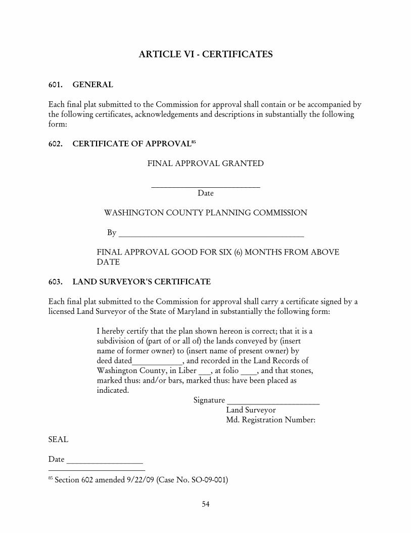
54
ARTICLE VI - CERTIFICATES 601. GENERAL Each final plat submitted to the Commission for approval shall contain or be accompanied by the following certificates, acknowledgements and descriptions in substantially the following form: 602. CERTIFICATE OF APPROVAL85
FINAL APPROVAL GRANTED
___________________________
Date
WASHINGTON COUNTY PLANNING COMMISSION
By ______________________________________________
FINAL APPROVAL GOOD FOR SIX (6) MONTHS FROM ABOVE DATE
603. LAND SURVEYOR'S CERTIFICATE Each final plat submitted to the Commission for approval shall carry a certificate signed by a licensed Land Surveyor of the State of Maryland in substantially the following form: I hereby certify that the plan shown hereon is correct; that it is a
subdivision of (part of or all of) the lands conveyed by (insert name of former owner) to (insert name of present owner) by deed dated ____________, and recorded in the Land Records of Washington County, in Liber ___, at folio ____, and that stones, marked thus: and/or bars, marked thus: have been placed as indicated.
Signature _______________________ Land Surveyor Md. Registration Number: SEAL Date ___________________ 85 Section 602 amended 9/22/09 (Case No. SO-09-001)
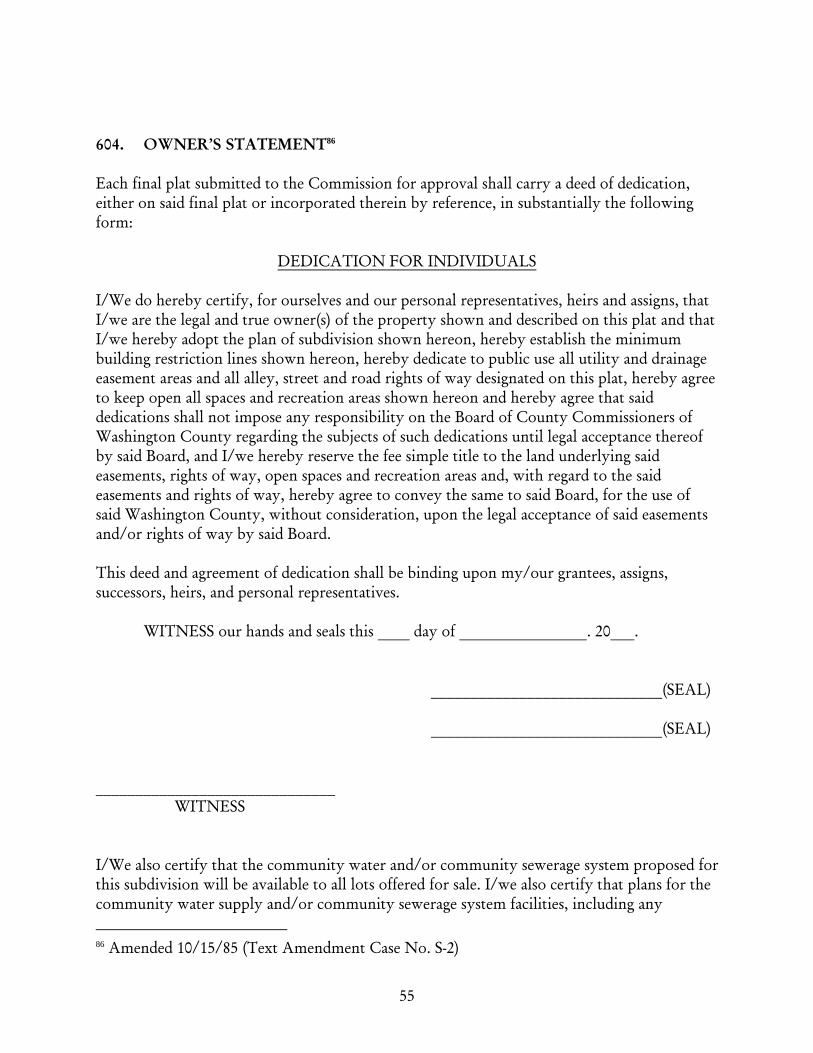
55
604. OWNER’S STATEMENT86 Each final plat submitted to the Commission for approval shall carry a deed of dedication, either on said final plat or incorporated therein by reference, in substantially the following form: DEDICATION FOR INDIVIDUALS I/We do hereby certify, for ourselves and our personal representatives, heirs and assigns, that I/we are the legal and true owner(s) of the property shown and described on this plat and that I/we hereby adopt the plan of subdivision shown hereon, hereby establish the minimum building restriction lines shown hereon, hereby dedicate to public use all utility and drainage easement areas and all alley, street and road rights of way designated on this plat, hereby agree to keep open all spaces and recreation areas shown hereon and hereby agree that said dedications shall not impose any responsibility on the Board of County Commissioners of Washington County regarding the subjects of such dedications until legal acceptance thereof by said Board, and I/we hereby reserve the fee simple title to the land underlying said easements, rights of way, open spaces and recreation areas and, with regard to the said easements and rights of way, hereby agree to convey the same to said Board, for the use of said Washington County, without consideration, upon the legal acceptance of said easements and/or rights of way by said Board. This deed and agreement of dedication shall be binding upon my/our grantees, assigns, successors, heirs, and personal representatives. WITNESS our hands and seals this ____ day of ________________. 20___. _____________________________(SEAL) _____________________________(SEAL) ______________________________ WITNESS I/We also certify that the community water and/or community sewerage system proposed for this subdivision will be available to all lots offered for sale. I/we also certify that plans for the community water supply and/or community sewerage system facilities, including any 86 Amended 10/15/85 (Text Amendment Case No. S-2)

56
necessary point of discharge, have been approved by the Department of Health and Mental Hygiene. (This paragraph shall be used only where public facilities are planned for the subdivision). There are no suits, actions at law, leases, liens, mortgages, trusts, easements or rights of way affecting the property included in this Plan of Subdivision except the following: and all parties having an interest therein have hereunto affixed their signatures, indicating their assent to this Plan of Subdivision. I/We do hereby assent to this Plan of Subdivision. WITNESS our hands and seals this ___ day of __________, 20___.
____________________________________ (SEAL) ____________________________________ (SEAL) ______________________________ WITNESS
CERTIFICATION FOR LENDING INSTITUTIONS We do hereby assent to this Plan of Subdivision: ____________________________________ (SEAL) ____________________________________ (SEAL) ______________________________ WITNESS 605. CERTIFICATE OF APPROVAL - INDIVIDUAL WATER SUPPLY AND
INDIVIDUAL SEWERAGE SYSTEM (Required for Preliminary and Final Plats) I hereby certify that the minimum ownership area complies with the minimum width and minimum area requirements specified in COMAR 10.17.03.03. Such minimum ownership shall remain equal to the minimum width and minimum area set forth in COMAR
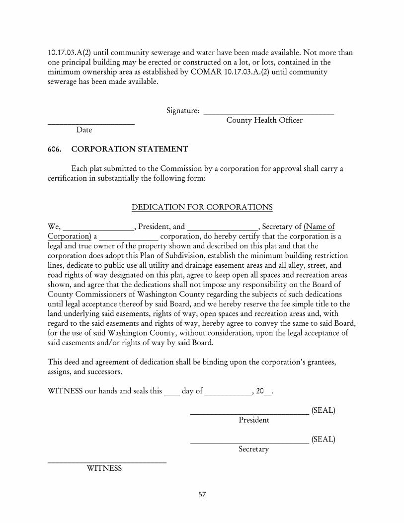
57
10.17.03.A(2) until community sewerage and water have been made available. Not more than one principal building may be erected or constructed on a lot, or lots, contained in the minimum ownership area as established by COMAR 10.17.03.A.(2) until community sewerage has been made available. Signature: _________________________________ ______________________ County Health Officer Date 606. CORPORATION STATEMENT Each plat submitted to the Commission by a corporation for approval shall carry a certification in substantially the following form:
DEDICATION FOR CORPORATIONS We, __________________, President, and __________________, Secretary of (Name of Corporation) a _______________ corporation, do hereby certify that the corporation is a legal and true owner of the property shown and described on this plat and that the corporation does adopt this Plan of Subdivision, establish the minimum building restriction lines, dedicate to public use all utility and drainage easement areas and all alley, street, and road rights of way designated on this plat, agree to keep open all spaces and recreation areas shown, and agree that the dedications shall not impose any responsibility on the Board of County Commissioners of Washington County regarding the subjects of such dedications until legal acceptance thereof by said Board, and we hereby reserve the fee simple title to the land underlying said easements, rights of way, open spaces and recreation areas and, with regard to the said easements and rights of way, hereby agree to convey the same to said Board, for the use of said Washington County, without consideration, upon the legal acceptance of said easements and/or rights of way by said Board. This deed and agreement of dedication shall be binding upon the corporation's grantees, assigns, and successors. WITNESS our hands and seals this ____ day of ____________, 20__. ______________________________ (SEAL) President ______________________________ (SEAL) Secretary ______________________________ WITNESS
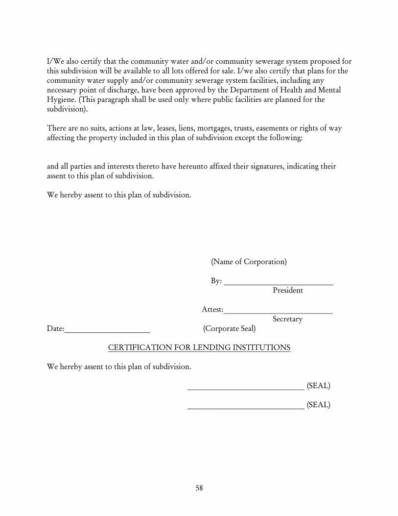
58
I/We also certify that the community water and/or community sewerage system proposed for this subdivision will be available to all lots offered for sale. I/we also certify that plans for the community water supply and/or community sewerage system facilities, including any necessary point of discharge, have been approved by the Department of Health and Mental Hygiene. (This paragraph shall be used only where public facilities are planned for the subdivision). There are no suits, actions at law, leases, liens, mortgages, trusts, easements or rights of way affecting the property included in this plan of subdivision except the following: and all parties and interests thereto have hereunto affixed their signatures, indicating their assent to this plan of subdivision. We hereby assent to this plan of subdivision. (Name of Corporation) By: ____________________________ President Attest:____________________________ Secretary Date:______________________ (Corporate Seal)
CERTIFICATION FOR LENDING INSTITUTIONS We hereby assent to this plan of subdivision. ______________________________ (SEAL) ______________________________ (SEAL)

59
607. CERTIFICATE OF APPROVAL OF COMMUNITY WATER AND/OR SEWERAGE SYSTEM
I hereby certify that the use of the community water and/or community sewerage system for this subdivision is in conformance with the County Water and Sewerage Plan. _____________________________ (SEAL) County Health Officer Date:______________________ 608. INTERIM FACILITIES PROVISION CERTIFICATION In compliance with COMAR 10.17.01.05.B. (1) and (2), the individual water supply and/or sewer system is hereby permitted on a temporary interim basis. Future lot owners are advised that the individual systems serving the lot indicated on this plat are of a temporary interim nature and that connection to a future community system shall be made within one (1) year or less after the system becomes available. I:\Ordinance\Subdivision\Subdivision Ordinance\ORD\Current Official 12-02-09.doc
Top Related