


Languages
Pages
Legal

SCHEDULE 3: STANDARDS FOR ARCHAEOLOGICAL IMPACT ASSESSMENT
AND REPORTING IN DEBERT AND BELMONT, NOVA SCOTIA
M ARCH 31, 2008
INTRODUCTION
In March 2008, regulations to the Special Places Protection Act were adopted by theProvince of Nova Scotia that state ‘A person must not excavate or otherwise disturb thesoil of any portion of the Debert Lands without first completing an archaeologicalresource impact assessment under a heritage research permit for that portion of theDebert Lands.’ The Department of Tourism, Culture and Heritage and the Assembly ofNova Scotia Mi’kmaq Chiefs have developed a Memorandum of Understanding (MOU)that states: “the intent of the Memorandum of Understanding and the attachedarchaeological standards is to provide for a joint Province of Nova Scotia – Mi’kmaq ofNova Scotia input and recommendation process for the issuance of heritage research forCategory C archaeological impact assessments on the Debert lands.”
The following standards for archaeological testing and resource impact assessment in theDebert and Belmont areas of Nova Scotia recognize the distinct context and history of thePalaeo Indian sites and finds that are scattered over more than 1000 acres in diversetopography and sediments. The Standards are archaeological testing procedures and datarecording methods that reflect the research importance and heritage significance of thesesites as well as the specialized geological knowledge required for testing for the presenceof these resources. These standards are designed to work in conjunction with thecompanion documents outlined below, which collectively guide the administration,implementation & review of the archaeological impact assessment process in the Debert-Belmont area.
The Standards have been developed to identify archaeological resources in a thoroughand efficient manner and to provide information for the assessment and management ofsignificant archaeological resources. There are two sections detailed by the Standards: I.Required Archaeological Testing Standards; and II. Resource Assessment Standards.Two appendices complete this document: Appendix 1: Debert site artifact densities andequivalent shovel test counts, and Appendix 2: Shovel Test Record Form.
Any archaeologist directing an archaeological impact assessment on the specified Debertlands will be required to take a one day orientation workshop offered by the HeritageDivision of the Department of Tourism, Culture and Heritage and the Confederacy ofmainland Mi’kmaq. All consultants and proponents are reminded that while theseStandards are designed to identify the absence or presence of Palaeo-Period sites, anyarchaeological resources located must be recorded and reported as required by thearchaeological permit guidelines for the Special Places Protection Act.
2
PHASE I: REQUIRED ARCHAEOLOGICAL IMPACT TESTING FOR AREAS, LINEAR
CORRIDORS, POINTS AND EMERGENCY RESPONSE
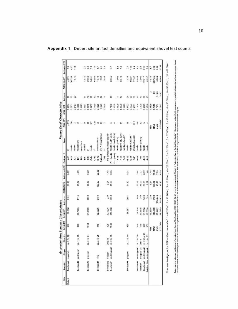
The most important factors considered in the development of the Standards are thegeological contexts of the known archaeological deposits at the Debert and Belmontsites, and the artifact densities per m from the original Debert site archaeological2
excavations (see Appendix 1). The Standards maintain a default testing strategy where asingle shovel test unit will detect a site of 6.25 m diameter with 80% certainty on thebasis of a single artifact. Statistical tests with figures from Appendix 1 indicate that mostdocumented artifact scatters at the Debert site would be detected with an 80-100%confidence level. Where this standard cannot be maintained, archaeological monitoringduring development is required. Four archaeological impact testing scenarios areanticipated on the Debert Lands: area testing; linear corridor testing; point locationtesting, and; testing resulting from an emergency situation.
Area Impact TestingAn area is defined for the purposes of these Standards as any tract of land that exceeds 5meters in any horizontal dimension.
1. The geographical and geological contexts of the land parcel or lot to be assessedmust be clearly documented, including a description of the origins and extent ofprimary sediments, any relevant and distinguishing topographic features and clearboundary limits for the area. Further detail will be required for documenting thestratigraphy of specific test pits as described below and shown on the Shovel TestRecord (Appendix 2). The level of information must allow for a Phase IIassessment of geological significance in relationship to any archaeological findsresulting from Phase I testing.
2. Phase I archaeological area testing will require shovel test pits that are 40 cm squareat an interval and depth defined below. In areas that are clear of surface growth ordebris, fixed mechanical coring is permitted. The core must be powered from thepower take-off of a backhoe, tractor, or similarly powered machine. The core mustbe at least 40 cm in diameter. Hand-operated power coring is not permitted.
3. All excavated soil must be screened through 6 mm hardware mesh or imperialequivalent (1/4").
4. Units are placed at a uniform 5m interval for areas less than 60 m x 60 m (3600 m2
or any configuration there of). For areas larger than 3600 m , units are also2
arranged in 5 m intervals but placed on a 20 m x 20 m grid, where only every other20 m x 20 m survey square is tested. No areas deemed "low potential" or "non-relevant" due to topography or disturbance will be excluded from assessment. Unitsmay only be skipped where access to the unit is impossible, for example a test pitlocation in standing water.
3
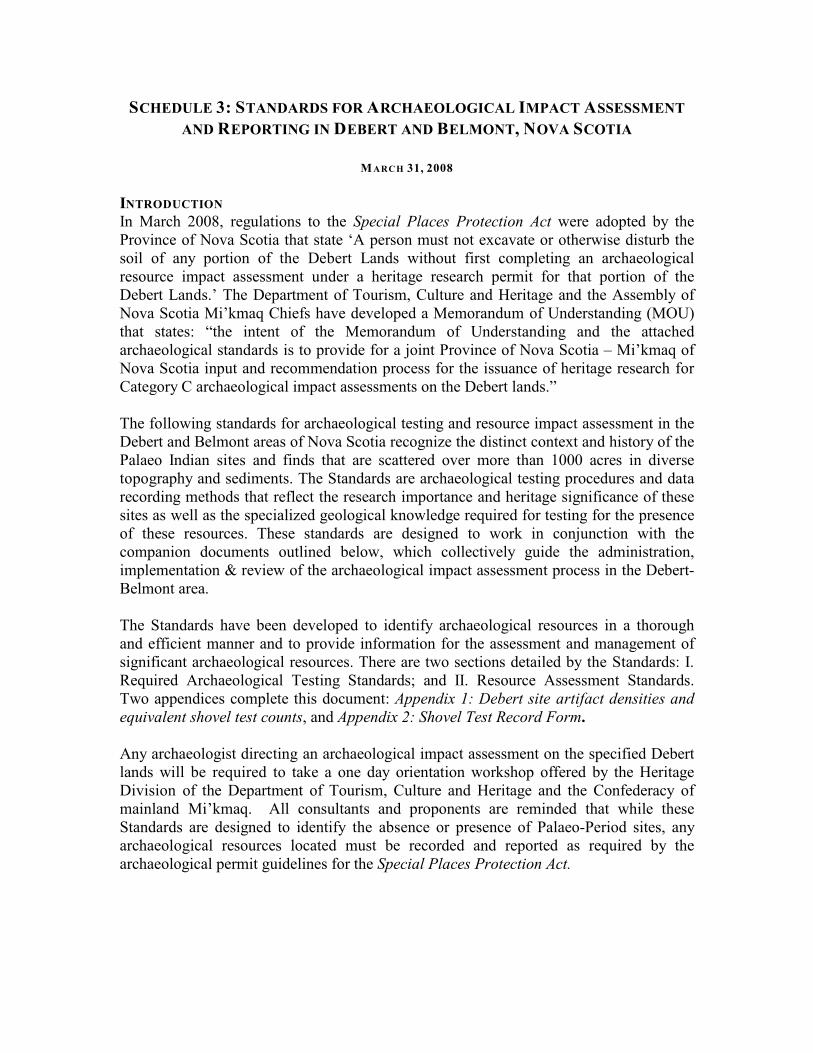
Figure 1 illustrates shovel test units placed at 5m intervals. This configuration applies forall areas less than 3600 m . The archaeological contractor will decide whether to use a2
square (left) or staggered (right) grid placement.
Fig. 1. Comparative layouts of square (L) and staggered (R) 5 m STP transect grids in a 20 m x 20
m survey square.
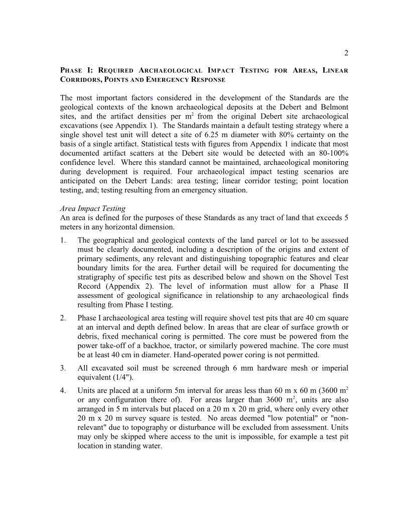
Figure 2 illustrates the grid configuration if the area is larger than 60 m x 60 m (3600m ). In this case a 20 m x 20 m grid of 5m interval tests-pits, where every other 20 m x2
20 m square is tested, can be used.
(a)100 m x100 m (b) 30 m x 100 m
Fig. 2. a) 100 m x 100 m checker board grid of 13 20 m survey squares (n = 297 STPs on a
square 5x 5 m test interval v. 286 STPs on staggered 5 m x 5 m interval), compared to; b)
30 m x 100 m survey tract with systematic 5m x 5 m grid (n = 147 STPs).
4
5. The geological context of the Debert sites requires that excavation must reachglacial till and/or weathered bedrock unless water levels are encountered at depthsuch that further excavation is not possible. This depth and context must be clearlydemonstrated on the Shovel Test Record form and fully documented in the permitreport.
The depth of glacial till and/or weathered bedrock has been found to be quitevariable, ranging from 50 cm to in excess of 175 cm, depending on factors of slope,elevation and localized geological events. Until recently, the deepest artifact foundwas at a depth of 105 cm and most archaeological deposits have been recorded atshallower depths.
Permit holders are encouraged to expand individual test unit dimensions for ease ofexcavation and recording, if necessary when working with deeper units.
In areas of 20 century activity and surface modification, contemporary fill depositsth
have been recorded extending to well beyond 150 cm below surface, burying theunderlying soil horizons. The field archaeologist may propose to mechanicallyremove deep, modern fill that is demonstrated through employing these testingstandards not to contain Mi’kmaq heritage archaeological resources. This stepwould be undertaken in order to facilitate efficient testing of soils below the modernfill. The archaeologist will contact the Manager, Special Places Program who willfollow the process outlined in Appendix 3 of these Standards to involve thedesignated representative of the Assembly of Nova Scotia Mi’kmaq Chiefs.
If Mi’kmaq heritage archaeological resources have been found in contemporary fill– all soil must be screened from test units placed in modern fills.
6. In the event that more than 5% of the units do not reach till or weathered bedrock(i.e. presumed sterile soil), then archaeological monitoring of the non-tested areamust occur during construction. The required conditions for monitoring are:
a. Monitoring must be by an archaeologist who meets the requirements of theHeritage Research Permit archaeological guidelines;
b. The proponent must provide the monitor with open access to the site asnecessary to fulfill the conditions of the archaeological Heritage ResearchPermit.
c. Construction must cease if archaeological evidence is found;
d. Additional test units may be used instead of monitoring if deemed appropriatethrough this review process and the proponent desires this method.
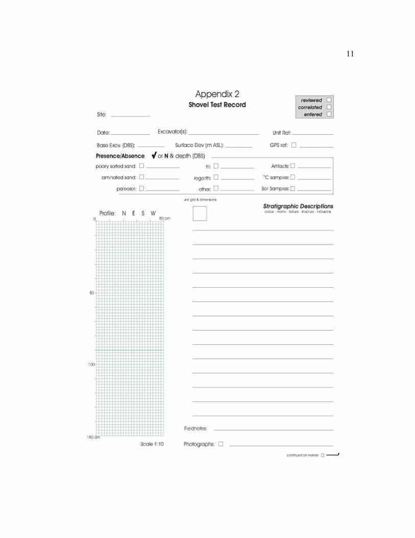
7. Reports for Phase I Archaeological Testing should follow the requirements for aCategory C Archaeological Resource Impact Assessment. In addition to these reportrequirements, each test unit must be mapped and the Shovel Test Record (seeAppendix 2) must be used to document the stratigraphy and details of each unit.Copies of the Shovel Test Record must be included in the final report.
Photographic records of shovel test profiles are a vital part of the documentationprocess for impact assessments. Ideally, one representative profile photo will betaken for each unit. A bare minimum level of recording for alternating
5
checkerboard testing of 20 m survey squares is a profile photo for the first unit oneach transect and every stratigraphical variation in subsequent units to the end ofthe transect.
The photograph must correspond to the profile sketch on the Shovel Test Recordform and must be taken at ground level to provide optimal perspective of the profiledetails. Additional photos are encouraged, where deemed appropriate to illustratedetail of a particular deposit/boundary/sequence or to highlight nonconformities inadjoining profiles. Profile photographs must be maintained to supplement thedocumentation of any archaeological evidence, including samples, recovered duringexcavation.
8. If archaeological evidence is located during Phase I Archaeological Testing, the sitemust proceed to Phase II Archaeological Resource Assessment.
Linear Corridor Impact Testing
A linear corridor for the purposes of these Standards is defined as a tract of land of anylength, but which does not exceed 5 meters in width. Land areas that exceed 5 meters inwidth will be assessed using the procedures outlined for area impact assessment.Examples of linear corridors include buried electrical cable runs, natural gas service linesand sewer or water service corridors.
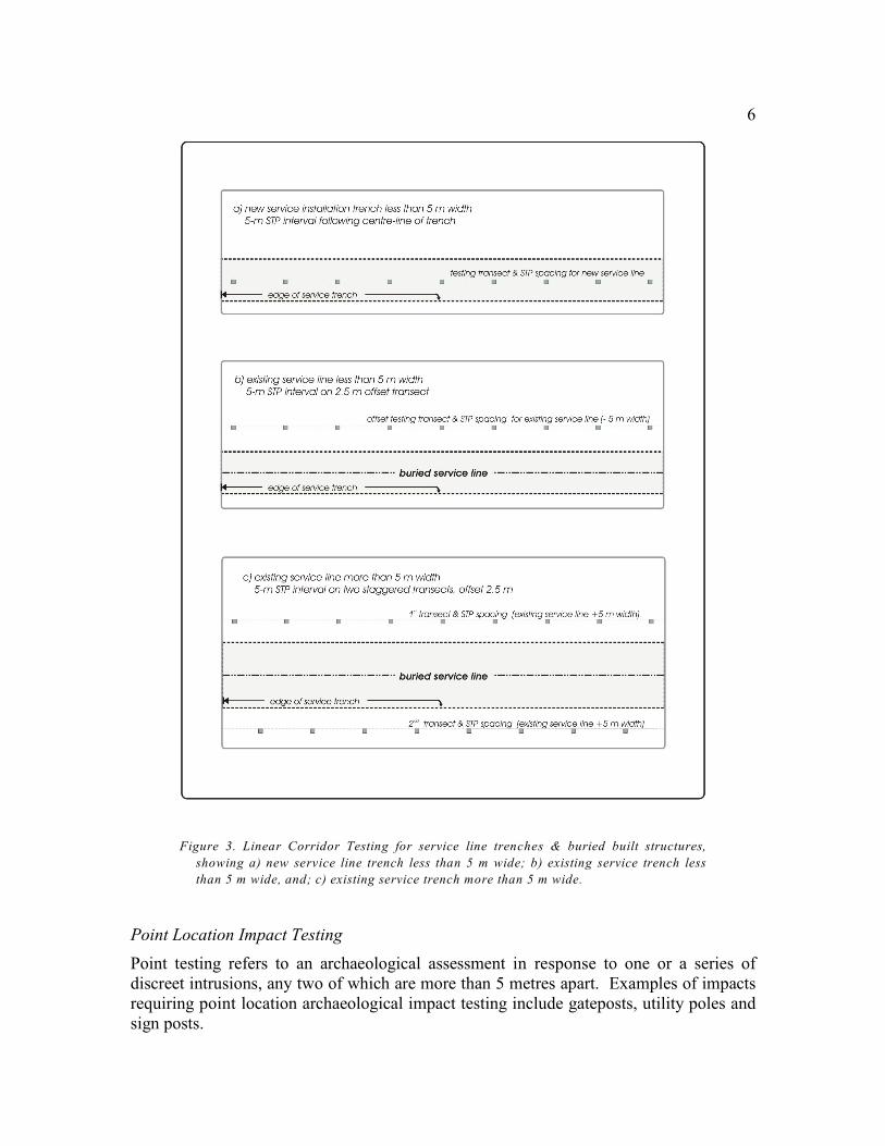
The testing standards for linear corridors follow the specific requirements describedabove for general area testing, with the exception that a single transect will be subject toarchaeological test excavation. All testing parameters defined for area testing includingtest pit area and depth will be followed. Where an existing utility or other built structureprevents testing to sufficient depth, an offset testing strategy is required. The offsettesting transect may be placed up to 2.5 meters from the center–line of the buried utility.A diagram illustrating a linear corridor testing transect and offset linear corridor testingtransects is shown in Figure 3.
6
Figure 3. Linear Corridor Testing for service line trenches & buried built structures,
showing a) new service line trench less than 5 m wide; b) existing service trench less
than 5 m wide, and; c) existing service trench more than 5 m wide.
Point Location Impact Testing
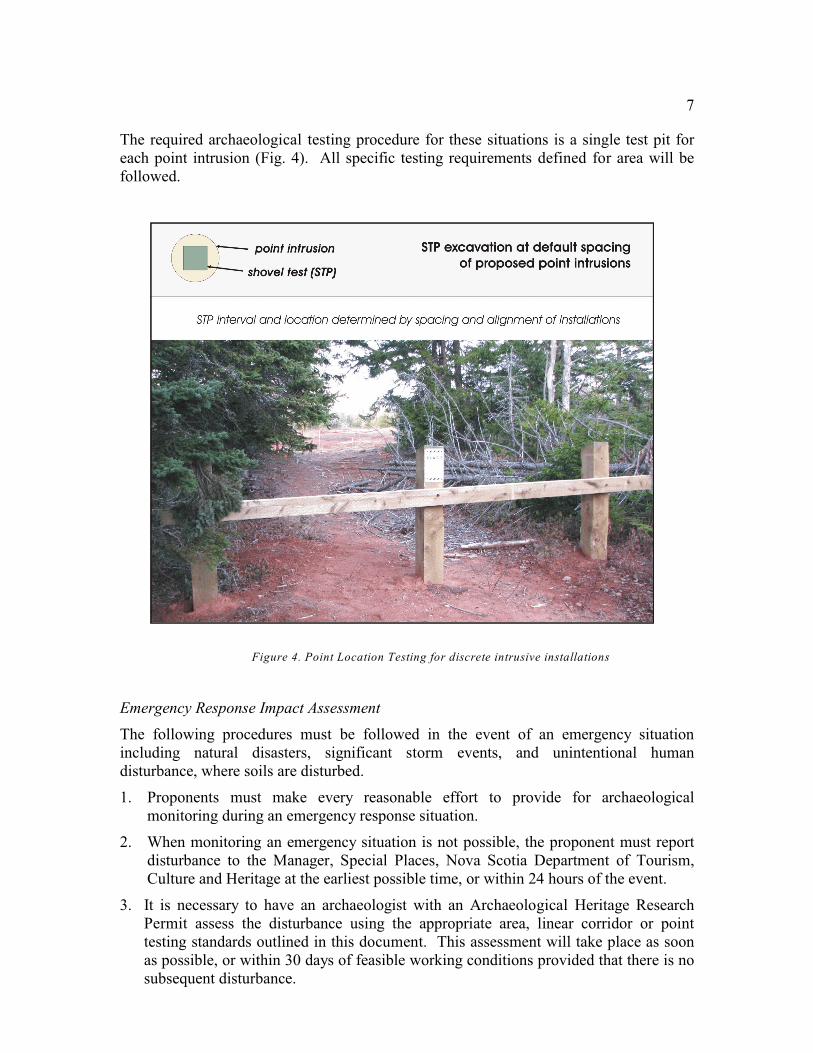
Point testing refers to an archaeological assessment in response to one or a series ofdiscreet intrusions, any two of which are more than 5 metres apart. Examples of impactsrequiring point location archaeological impact testing include gateposts, utility poles andsign posts.
7
The required archaeological testing procedure for these situations is a single test pit foreach point intrusion (Fig. 4). All specific testing requirements defined for area will befollowed.
Figure 4. Point Location Testing for discrete intrusive installations
Emergency Response Impact Assessment
The following procedures must be followed in the event of an emergency situationincluding natural disasters, significant storm events, and unintentional humandisturbance, where soils are disturbed.
1. Proponents must make every reasonable effort to provide for archaeologicalmonitoring during an emergency response situation.
2. When monitoring an emergency situation is not possible, the proponent must reportdisturbance to the Manager, Special Places, Nova Scotia Department of Tourism,Culture and Heritage at the earliest possible time, or within 24 hours of the event.
3. It is necessary to have an archaeologist with an Archaeological Heritage ResearchPermit assess the disturbance using the appropriate area, linear corridor or pointtesting standards outlined in this document. This assessment will take place as soonas possible, or within 30 days of feasible working conditions provided that there is nosubsequent disturbance.
8
4. The archaeologist must have reasonable access to any disturbed soils or disturbedlands provided that such access does not endanger any person or cause any additionalsignificant disturbance.
Phase II Archaeological Resource Assessment Standards
A Phase II Archaeological Resource Assessment is required when Mi’kmaq Heritagearchaeological evidence is found during Phase I Archaeological Impact Testing. Thepurpose of the assessment is to determine the extent and significance of the identifiedresource and to determine appropriate forms of mitigation. Given the nature of Phase IArchaeological Testing, additional testing is not automatically required during a Phase IIResource Assessment. However, if, as examples, the nature of a particular feature isambiguous or an association of an artifact with a topographic or geological deposit isunclear, further testing may be required of the proponent/consultant by the ReviewCommittee.
1. The assessment must address the following elements.
a. The relationships of the geological and topographical context for the resourcemust be defined. Questions to consider include:
1) Does the context or feature association address previously identifiedstratigraphic or geological questions and research issues, such as the verticallocation of artifacts solely in glacial versus redeposited/disturbed postglacialsediments?
2) Is there a stratigraphic layer that can be dated or otherwise analyzed in thefuture that warrants its protection from destruction?
3) Are there any other associated geological or topographical features thatcannot be recorded and documented or otherwise replicated throughfieldwork investigation that should be preserved for future research?
b. The description and significance of any features identified during Phase IArchaeological Testing must be completed before beginning Phase II testing:
1) Opportunities for dating or other lab analyses of such features should beindicated.
c. The range, diversity and total number of artifacts recovered during a Phase Isurvey must be recorded, including:
1) Descriptions of lithic material and artifact form; and
2) The relative uniqueness of an assemblage should be assessed.
d. The proximity of the finds to other known sites and a statement of thesignificance of the proximity must be specified.
e. The potential for additional artifact recovery, regardless of its context, and anassessment of the value of such a recovery is required.
f. Any known First Nation traditional or oral historical meaning related to theidentified resource, or resource location, must be referenced.
9
g. A statement is required on the overall future research potential of the identifiedresource.
2. Salvage recovery options may be approved as mitigation if the resources are deemednot to represent a significant archaeological resource given the assessment processdefined in these Standards. Salvage may include any of the following methods.
a. The excavation of an area deemed to have high potential for the recovery ofarchaeological evidence;
b. Archaeological monitoring during development that meets the following criteriamay be required.
1) Monitoring must be by an archaeologist who meets the applicantrequirements under the permit guidelines for the Special Places Protection Act.
2) The development proponent must provide free access to the site.
3) Construction must cease if archaeological evidence is located duringmonitoring to allow for assessment of the significance of finds.
4) Additional test units may substitute for monitoring if deemed appropriate bythe Review Committee (as defined in Appendix III) and desirable by theproponent.
c. Sampling of sediments or other geological features may be required.
d. Detailed site, stratigraphic and artifact recording may be required.
3. A decision may be made through this process to protect the site in situ. In such aninstance no further soil disturbance would be allowed.
10
Appendix 1. Debert site artifact densities and equivalent shovel test counts
11
Top Related