


Languages
Pages
Legal

5
Siberia - From Rodinia to Eurasia
Dmitry V. Metelkin, Valery A. Vernikovsky and Alexey Yu. Kazansky Trofimuk Institute of Petroleum Geology and Geophysics SB RAS
Russia
1. Introduction
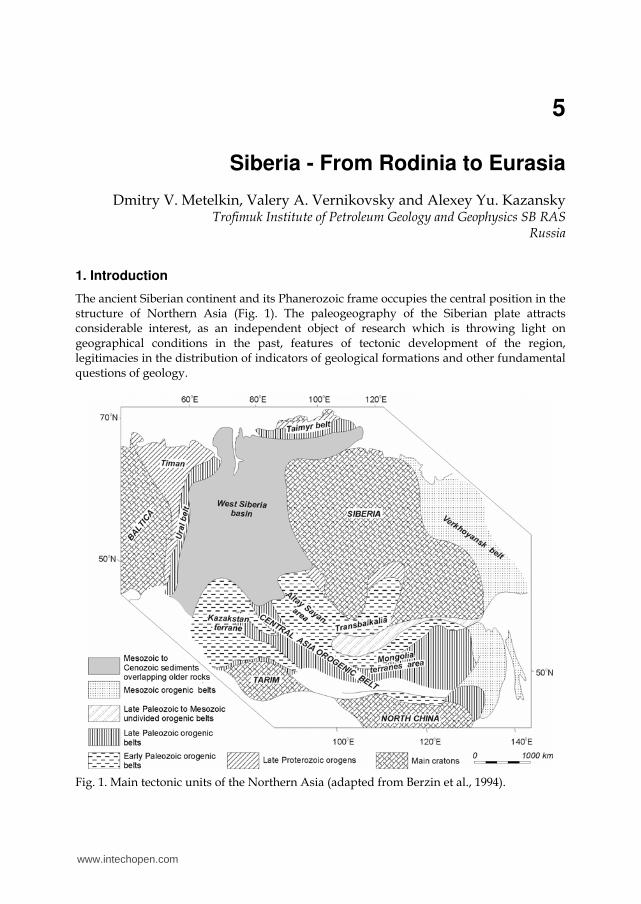
The ancient Siberian continent and its Phanerozoic frame occupies the central position in the structure of Northern Asia (Fig. 1). The paleogeography of the Siberian plate attracts considerable interest, as an independent object of research which is throwing light on geographical conditions in the past, features of tectonic development of the region, legitimacies in the distribution of indicators of geological formations and other fundamental questions of geology.
Fig. 1. Main tectonic units of the Northern Asia (adapted from Berzin et al., 1994).
www.intechopen.com

Tectonics
104
Here we present the results of a short analysis of paleomagnetic data obtained during recent years over the territory of the Siberian Craton and some adjacent terrains. The new data allows us to propose a new version of the apparent polar wander path (APWP), uniting three large intervals of geological history: Neoproterozoic, Paleozoic and Mesozoic. This data allows a reconstruction of step-by-step tectonics of the Siberian continental plate for almost 1.0 Ga. It appears that large-scale long-living strike-slips were playing the major role in a tectonic history of the craton at all stages of development of the crust of its folded frame. Strike-slip motions defined the tectonic style of the evolution of folded systems as in the early stages of formation of oceanic basins, and during active subduction of oceanic crust and, undoubtedly, at the accretional-collisional stage. Intraplate deformations of the newly formed continental crust and accompanying active magmatism were also supervised by strike-slips motion of the fragments of different scale. The present work is an attempt to coordinate most of the paleomagnetic and geological information from different regions of Siberia forming a uniform picture in the context of a strike-slip hypothesis. Here we propose eight paleotectonic reconstructions corresponding to the key moments in the tectonic history of Siberia which describe a change of spatial position of the craton and support the leading role of strike-slip motions in the tectonic evolution of a continental crust of its frame on the base of paleomagnetic estimations. Those reconstructions are partly based on the author’s tectonic models published earlier, but the central place here belongs to the Siberian Craton.
2. The tectonics of the Siberian Craton
2.1 The geology of the Siberian Craton Siberian Craton occupies the central place in the structure of Northern Asia and is located between the largest rivers of Eastern Siberia - the Yenisey and Lena. The southeast boundary of the craton coincides with the Mongol-Okhotsk suture which separates the Early Paleozoic crystal complexes of Stanovoy block from the folded structures of the Mongol-Okhotsk belt developed at the end of Jurassic - Cretaceous (Zorin, 1999; Kravchinsky et al., 2002; Tomurtogoo et al., 2005; Metelkin et al., 2010a). Westward, the fields of Early Cambrian formations of Stanovoy block are “lost” among granitoid batholiths of the Baikal folded area. Here, the Zhuinsk system of faults is accepted as a boundary of the craton crystal complexes. Within the limits of Northern Transbaikalia, the boundary of the Siberian Craton is going inside a well expressed Baikal-Patom paleoisland arc. During Neoproterozoic and Paleozoic this territory was represented by a sedimentary basin on the margin of Siberian continent and was deformed as a result of accretional-collisional events (Parfenov et al., 2003; Khain et al., 2003; Zorin et al., 2009). The Sayan-Yenisey folded-napped structure forms the southwestern margin of the ancient continent. Further to the southwest, a mosaic of terrains of Altay-Sayan fragment of the Central-Asian mobile belt is located. At the western periphery the craton block is overlapped by Mesozoic-Cenozoic cover of the West Siberian plate and the boundary of the craton is conventionally traced over the Yenisey river valley. In the north, the platform deposits of Siberian Craton are buried under sediments of the Yenisey-Khatanga trough, which is considered as a branch of the West Siberia basin, and are limited the by structures of the Taimyr-Severnaya Zemelya folded-napped area. The eastern periphery of the Siberian Craton is formed by the deformed complexes of the Verkhoyansk folded-napped system. Here, predominantly sedimentary complexes deposited within the margin of the Siberian continent during the Paleozoic and Mesozoic, were detached and were broken from the crystal basement and pulled over the craton
www.intechopen.com
Siberia - From Rodinia to Eurasia
105
(Parfenov et al., 1995; Oxman, 2003). The Verkhoyansk trough, developed at the frontal part of the napes, is accepted as a modern boundary of distribution of the low-deformed cover of the Siberian Craton. Thus, the most ancient crystal complexes of the craton are traced practically everywhere under the mountain ridges of the surrounding folded-napped belts, and the outlined boundaries represent the arbitrary contours used for paleotectonic reconstruction. The Archean-Paleoproterozoic crystal basement is exposed in the limits of the Aldan-
Stanovoy shield in the southeast and in the limits of Anabar-Olenek uplift in the north and
also as relatively small missives among folded-napped structures of the cratonic margin in
the south-west. Granulite-gneissic and granite-greenschist complexes undoubtedly are
prevailing and form a number of terrains developed discretely between 3.3 and 2.5 billion
years ago (Rozen et al., 1994; Rosen, 2003; Smelov, Timofeev, 2007). A collision of terrains
and a build-up of the craton have taken place about 1.8 billion years ago (Rozen et al., 2005;
Smelov, Timofeev, 2007).
The sedimentary cover is formed by Late Proterozoic and Phanerozoic deposits.
Mesoproterozoic and Neoproterozoic geological complexes on the Siberian Craton are
concentrated over its margins, forming both a sedimentary sequences comparable to
conditions of shelf basins (Pisarevsky & Natapov, 2003), and magmatic (volcanic and the
volcano-sedimentary) complexes connected with oceanic spreading and subduction
processes on the continental margin. The last are included in Neoproterozoic folded belts
surrounding the craton: the Central Taimyr, Pre-Yenisey and Baikal-Muya belts. Early
Paleozoic sedimentary complexes are widespread and occupy all territory of the plate.
Shallow sea and lacustrine terrigenous-carbonate and gypsum-dolomite deposits
predominate (Kanygin et al., 2010). A new stage in the development of the plate complex
began in the Devonian and has been connected with the continental rift event. Rifting has
driven the generation of the Vilyui graben system and the extensive sedimentary basin in
the east of the Siberian plate which was developed up to the end of the Mesozoic and
resulted in the Vilyui syncline structure which is infilled mainly by terrigenous deposits
(Parfenov & Kuzmin, 2001). The Permian-Triassic platobasaltic sequence and underlying
Carboniferous- Permian terrigenous and the tuff deposit of the Tungus tectonic province is
considered as an independent structural complex of the Siberian platform. The development
of the depression here is connected with a stretching and thinning of the continental crust
above an extensive hotspot in the mantle, so the thick trapp complex appears to be a direct
reflection of the largest plum activity (Dobretsov & Vernikovsky, 2001). Moreover, the
Permian-Triassic boundary coincides with rifting in the northwest frame of the Siberian
Craton. The giant sedimentary basins of West Siberia, including the Yenisey-Khatanga
trough, have occupied the adjusting, lowered margins of the platform. Late Mesozoic
collisional processes in the east and the south of the craton have completed the development
of the modern structure of the Siberian platform.
2.2 The paleomagnetic record The apparent polar wander path (APWP) for Siberia is well known only for Paleozoic. Today, not less than four versions of this trend are proposed (Khramov, 1991; Pechersky & Didenko, 1995; Smethurst et al., 1998; Cocks & Torsvik, 2007). Distinctions between the paths are caused by different approaches in data selection, the non-uniform distribution of data over a time scale, and also by a “smoothing” technique during the construction of
www.intechopen.com
Tectonics
106
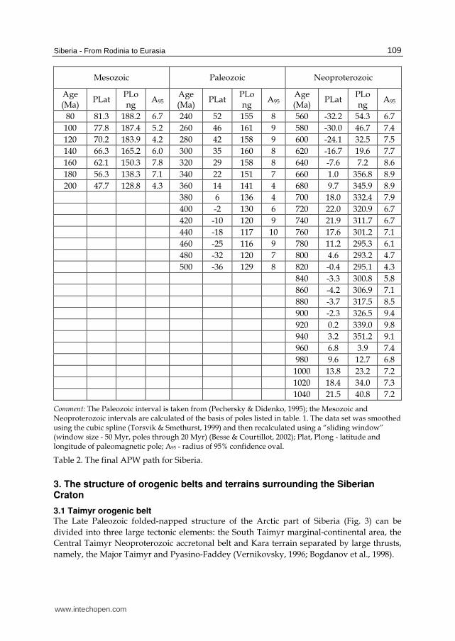
APWP. Despite differences in details, the general character of the Paleozoic polar wander is co-coordinated and describes the northward drift of Siberia from the equator to high latitudes of the northern hemisphere with a prevailing clockwise rotation (Pechersky & Didenko, 1995; Cocks & Torsvik, 2007). The maximum drift velocity sometimes exceeded from 5 to 12 cm/year while the amplitude of rotation went up to 1 degree per million years, depending on an APWP version which was used. We constructed the Neoproterozoic interval of APWP on the basis of a refined summary
table of Precambrian poles (Metelkin et al., 2007а) where most of key poles (reliability index
(Van der Voo, 1990) more than 3) from Siberia were obtained in resent years (Table 1).
In particular the analysis carried out (Metelkin et al., 2007а), proves nonconventional for the
Siberia “eastern” drift (from outside the Indian ocean) of the poles comprising in
Neoproterozoic a characteristic loop comparable with the well known “Grenville Loop” of
APWP for Laurentia (McElchinny & McFadden, 2000). The similarity of the APWP shapes
for Siberia and Laurentia not only quite unequivocally proves a tectonic connection of the
cratons within the structure of Neoproterozoic, but also allows a reconstruction of the
dynamics of its break-up (Metelkin et al., 2007а, Vernikovsky et al., 2009). The plate
kinematics for the first third of the Neoproterozoic can be described by a southward drift
with a counter-clockwise rotation from the equatorial to the moderate latitudes of the
southern hemisphere. The second third of the Neoproterozoic is characterized by a reversed
drift of the plate to the equator with a clockwise rotation. The calculated drift velocity as a
rule does not exceed 10 cm/year, and the amplitude of rotation less than 1 degree per
million years.
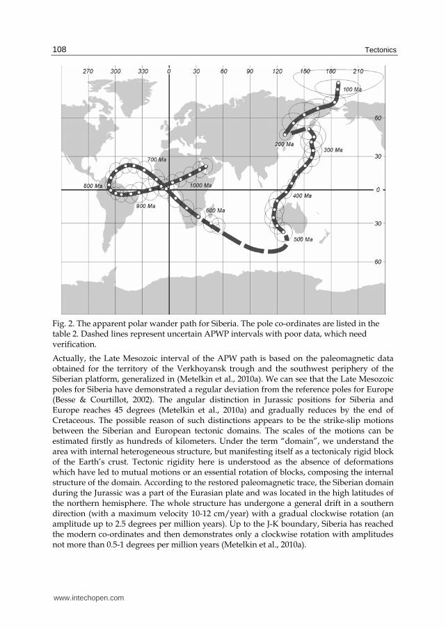
However, the Vendian (Ediacarian - from to 600 million years ago to 540 million years ago)
APWP interval connecting the above mentioned Neoproterozoic and Paleozoic APWP
trends (Fig. 2, Table 2) still remains ambiguous. For 560 million years we used the mean pole
of the group which is concentrated near Madagascar Island (tab. 1). However, we also
cannot exclude a more southern pole position for this time - which is near the coast of
Antarctica (Shatsillo et al., 2005, 2006). Despite the essential progress in the study of Late
Precambrian and a considerable quantity of new paleomagnetic data, the problem of the
paleomagnetic pole position for the Vendian time is far from an unequivocal solution. A
number of hypotheses were proposed and among them: a non-stationary, non-dipolar state
of the geomagnetic field at this time, abnormaly high drift velocities and some others
(Kirshvink et al., 1997; Meert et al., 1999; Kravchinsky et al., 2001; Kazansky, 2002; Pavlov et
al., 2004; Shatsillo et al., 2005, 2006).
A serious problem whose solution can probably provide the answer to the majority of points
of disagreement is the problem of the absolute age of the rocks studied and the age of
magnetization preserved in them. Despite the described difficulties, the distribution of
Vendian- Early Cambrian poles fits the expected trend between Neoproterozoic and
Paleozoic APWP segments (Fig. 2).
Also there is unequivocal substantiation for the Early Mesozoic segment of the Siberian
APWP due to the absence of authentic data for Middle and Late Triassic. A combination of
Paleozoic and constructed Late Mesozoic segments (Fig. 2, Table 2) assumes the presence of
a strongly pronounced casp (an interval with a sharp change in polar wander). The presence
of the casp is basically not connected with the tectonic reasons, but is caused by a technique
of APWP calculation during the smoothing of selected data over time intervals.
www.intechopen.com

Siberia - From Rodinia to Eurasia
107
Pole position Object age, Ma
(ºN) (ºE) A95 Reference
1050 - 640 Ma
Malga Fm, , Uchur-Maya district 1045±20 25.4 50.4 2.6 Gallet et al., 2000
Lakhanda Group., Uchur-Maya district 1000-1030
13.3 23.2 10.7
Pavlov et al., 2000
Ui Group, including sills, Uchur-Maya district
950-1000 4.9 357.7 4.3 Pavlov et al., 2002
Karagass Group, Pre-Sayan trough 800-740 4.2 292.1 6.2 Metelkin et al., 2010b
Nersa Complex, Pre-Sayan trough 741±4 1 22.7 309.8 9.6 Metelkin et al., 2005a
Predivinsk Complex, Yenisei Ridge 637±5.7 2 -8.2 7.7 4.7 Metelkin et al., 2004а
600-530 Ma
Aleshino Fm, , Yenisei Ridge 600-550 -28.3 24.3 7.7 Shatsillo et al., 2006
Carbonates, Igarka district 560-530 -33.4 45.6 12.7
Kazansky, 2002
Carbonates, Lena-Anabar district 560-530 -28.0 66.5 8.2 Kazansky, 2002
Aisin Fm., Pre-Sayan area 600-545 -39.9 75.1 12.1
Shatsillo et al., 2006
Taseevo supergroup Yenisei Ridge 600-545 -32.9 75.1 6.1 Shatsillo et al., 2006
Taseevo supergroup Yenisei Ridge 600-545 -41.0 91.0 15.4
Pavlov & Petrov, 1997
Ushakovka Fm., , Transbaikalia 600-545 -31.6 63.8 9.8 Shatsillo et al., 2005 3
Sediments, Pre-Sayan area and Yenisei Ridge
560-530 -29.5 74.1 4.5 Shatsillo et al., 2006 3
Kurtun Fm., Transbaikalia 560-530 -25.3 54.5 12.0
Shatsillo et al., 2005 3
Irkutsk Fm., Transbaikalia 560-530 -36.1 71.6 3.2 Shatsillo et al., 2005 3
Minua Fm., Transbaikalia 600-530 -33.7 37.2 11.2
Kravchinsky et al., 2001
Shaman Fm., Transbaikalia 600-530 -32.0 71.1 9.8 Kravchinsky et al.,
2001
MEAN ~ 560 -33.9 62.2 8.9
200-80 Ma
Sediments, Lena River 175-245 47.0 129.0 9.0 * Pisarevsky, 1982
Basalts of Tungui depression, Transbaikalia
180-200 43.3 131.4 23.0
Cogné et al., 2005
Sediments, Verkhoynask trough 170-160 59.3 139.2 5.7 Metelkin et al., 2008
Badin Fm., Transbaikalia 150-160 64.4 161.0 7.0 Kravchinsky et al.,
2002
Ichechui Fm., Transbaikalia 150-160 63.6 166.8 8.5 Metelkin et al., 2007b
Sediments, Verkhoyansk trough 140-120 67.2 183.8 7.8 Metelkin et al., 2008
Khilok Fm, , Transbaikalia 110-130 72.3 186.4 6.0 Metelkin et al., 2004b
Intrusions, Minusa trough 74-82 82.8 188.5 6.1 Metelkin et al., 2007c
Comment: 1 - age according to (Gladkochub et al., 2006); 2 - age according to (Vernikovsky et al., 1999); 3
- “anomalous” (non-dipolar) field according to the viewpoint of data authors; * Pisarevsky, 1982: pole
#4417 from IAGA GPMDB. (http://www.ngu.no/geodynamics/gpmdb/).
Table 1. Selected paleomagnetic poles from Siberia used for calculation of the Neoproterozoic and Mesozoic intervals of the Siberian APWP.
www.intechopen.com
Tectonics
108
Fig. 2. The apparent polar wander path for Siberia. The pole co-ordinates are listed in the table 2. Dashed lines represent uncertain APWP intervals with poor data, which need verification.
Actually, the Late Mesozoic interval of the APW path is based on the paleomagnetic data obtained for the territory of the Verkhoyansk trough and the southwest periphery of the Siberian platform, generalized in (Metelkin et al., 2010a). We can see that the Late Mesozoic poles for Siberia have demonstrated a regular deviation from the reference poles for Europe (Besse & Courtillot, 2002). The angular distinction in Jurassic positions for Siberia and Europe reaches 45 degrees (Metelkin et al., 2010a) and gradually reduces by the end of Cretaceous. The possible reason of such distinctions appears to be the strike-slip motions between the Siberian and European tectonic domains. The scales of the motions can be estimated firstly as hundreds of kilometers. Under the term “domain”, we understand the area with internal heterogeneous structure, but manifesting itself as a tectonicaly rigid block of the Earth’s crust. Tectonic rigidity here is understood as the absence of deformations which have led to mutual motions or an essential rotation of blocks, composing the internal structure of the domain. According to the restored paleomagnetic trace, the Siberian domain during the Jurassic was a part of the Eurasian plate and was located in the high latitudes of the northern hemisphere. The whole structure has undergone a general drift in a southern direction (with a maximum velocity 10-12 cm/year) with a gradual clockwise rotation (an amplitude up to 2.5 degrees per million years). Up to the J-K boundary, Siberia has reached the modern co-ordinates and then demonstrates only a clockwise rotation with amplitudes not more than 0.5-1 degrees per million years (Metelkin et al., 2010a).
www.intechopen.com
Siberia - From Rodinia to Eurasia
109
Mesozoic Paleozoic Neoproterozoic
Age (Ma)
PLat PLong
A95 Age (Ma)
PLat PLong
A95 Age (Ma)
PLat PLong
A95
80 81.3 188.2 6.7 240 52 155 8 560 -32.2 54.3 6.7
100 77.8 187.4 5.2 260 46 161 9 580 -30.0 46.7 7.4
120 70.2 183.9 4.2 280 42 158 9 600 -24.1 32.5 7.5
140 66.3 165.2 6.0 300 35 160 8 620 -16.7 19.6 7.7
160 62.1 150.3 7.8 320 29 158 8 640 -7.6 7.2 8.6
180 56.3 138.3 7.1 340 22 151 7 660 1.0 356.8 8.9
200 47.7 128.8 4.3 360 14 141 4 680 9.7 345.9 8.9
380 6 136 4 700 18.0 332.4 7.9
400 -2 130 6 720 22.0 320.9 6.7
420 -10 120 9 740 21.9 311.7 6.7
440 -18 117 10 760 17.6 301.2 7.1
460 -25 116 9 780 11.2 295.3 6.1
480 -32 120 7 800 4.6 293.2 4.7
500 -36 129 8 820 -0.4 295.1 4.3
840 -3.3 300.8 5.8
860 -4.2 306.9 7.1
880 -3.7 317.5 8.5
900 -2.3 326.5 9.4
920 0.2 339.0 9.8
940 3.2 351.2 9.1
960 6.8 3.9 7.4
980 9.6 12.7 6.8
1000 13.8 23.2 7.2
1020 18.4 34.0 7.3
1040 21.5 40.8 7.2
Comment: The Paleozoic interval is taken from (Pechersky & Didenko, 1995); the Mesozoic and Neoproterozoic intervals are calculated of the basis of poles listed in table. 1. The data set was smoothed using the cubic spline (Torsvik & Smethurst, 1999) and then recalculated using a “sliding window” (window size - 50 Myr, poles through 20 Myr) (Besse & Courtillot, 2002); Plat, Plong - latitude and longitude of paleomagnetic pole; A95 - radius of 95% confidence oval.
Table 2. The final APW path for Siberia.
3. The structure of orogenic belts and terrains surrounding the Siberian Craton
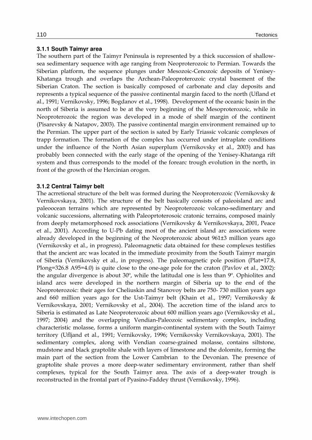
3.1 Taimyr orogenic belt The Late Paleozoic folded-napped structure of the Arctic part of Siberia (Fig. 3) can be
divided into three large tectonic elements: the South Taimyr marginal-continental area, the
Central Taimyr Neoproterozoic accretonal belt and Kara terrain separated by large thrusts,
namely, the Major Taimyr and Pyasino-Faddey (Vernikovsky, 1996; Bogdanov et al., 1998).
www.intechopen.com
Tectonics
110
3.1.1 South Taimyr area The southern part of the Taimyr Peninsula is represented by a thick succession of shallow-
sea sedimentary sequence with age ranging from Neoproterozoic to Permian. Towards the
Siberian platform, the sequence plunges under Mesozoic-Cenozoic deposits of Yenisey-
Khatanga trough and overlaps the Archean-Paleoproterozoic crystal basement of the
Siberian Craton. The section is basically composed of carbonate and clay deposits and
represents a typical sequence of the passive continental margin faced to the north (Ufland et
al., 1991; Vernikovsky, 1996; Bogdanov et al., 1998). Development of the oceanic basin in the
north of Siberia is assumed to be at the very beginning of the Mesoproterozoic, while in
Neoproterozoic the region was developed in a mode of shelf margin of the continent
(Pisarevsky & Natapov, 2003). The passive continental margin environment remained up to
the Permian. The upper part of the section is sated by Early Triassic volcanic complexes of
trapp formation. The formation of the complex has occurred under intraplate conditions
under the influence of the North Asian superplum (Vernikovsky et al., 2003) and has
probably been connected with the early stage of the opening of the Yenisey-Khatanga rift
system and thus corresponds to the model of the forearc trough evolution in the north, in
front of the growth of the Hercinian orogen.
3.1.2 Central Taimyr belt The acrretional structure of the belt was formed during the Neoproterozoic (Vernikovsky &
Vernikovskaya, 2001). The structure of the belt basically consists of paleoisland arc and
paleoocean terrains which are represented by Neoproterozoic volcano-sedimentary and
volcanic successions, alternating with Paleoprtoterosoic cratonic terrains, composed mainly
from deeply metamorphosed rock associations (Vernikovsky & Vernikovskaya, 2001, Peace
et al., 2001). According to U-Pb dating most of the ancient island arc associations were
already developed in the beginning of the Neoproterozoic about 961±3 million years ago
(Vernikovsky et al., in progress). Paleomagnetic data obtained for these complexes testifies
that the ancient arc was located in the immediate proximity from the South Taimyr margin
of Siberia (Vernikovsky et al., in progress). The paleomagnetic pole position (Plat=17.8,
Plong=326.8 A95=4.0) is quite close to the one-age pole for the craton (Pavlov et al., 2002):
the angular divergence is about 30º, while the latitudal one is less than 9º. Ophiolites and
island arcs were developed in the northern margin of Siberia up to the end of the
Neoproterozoic: their ages for Cheliuskin and Stanovоy belts are 750- 730 million years ago
and 660 million years ago for the Ust-Taimyr belt (Khain et al., 1997; Vernikovsky &
Vernikovskaya, 2001; Vernikovsky et al., 2004). The accretion time of the island arcs to
Siberia is estimated as Late Neoproterozoic about 600 million years ago (Vernikovsky et al.,
1997; 2004) and the overlapping Vendian-Paleozoic sedimentary complex, including
characteristic molasse, forms a uniform margin-continental system with the South Taimyr
territory (Ufljand et al., 1991; Vernikovsky, 1996; Vernikovsky Vernikovskaya, 2001). The
sedimentary complex, along with Vendian coarse-grained molasse, contains siltstone,
mudstone and black graptolite shale with layers of limestone and the dolomite, forming the
main part of the section from the Lower Cambrian to the Devonian. The presence of
graptolite shale proves a more deep-water sedimentary environment, rather than shelf
complexes, typical for the South Taimyr area. The axis of a deep-water trough is
reconstructed in the frontal part of Pyasino-Faddey thrust (Vernikovsky, 1996).
www.intechopen.com
Siberia - From Rodinia to Eurasia
111
Fig. 3. Tectonic map of the Taimyr - Severnaya Zemlya fold-and-thrust belt (after Vernikovsky & Vernikovskaya, 2001).
3.1.3 Kara terrain Kara terrain occupies the northern part of the territory, including the coastal part of the
Taimyr Peninsula, the islands of the Severnaya Zemlya archipelago and the adjacent floor of
the Kara Sea (Fig. 3). Three different rock associations can be distinguished here: i)
Paleoproterozoic metamorphic complexes of the crystal basement is represented by
palgiogneiss, amphibolite, and granitic gneiss (Ufland et al., 1991; Vernikovsky, 1996); ii)
Neoproterozoic-Cambrian deposits of continental slope and slope front has an essential
flysch structure and is represented by rhythmically alternating sandstone, siltstone and
mudstone, partly metamorphosed from green-schist to amphibolite facies (Bogolepova et
al., 2001; Lorenz et al., 2008); iii) relatively low deformed sequences of sedimentary cover
with predominant coastal-sea and lagoon facies (limestone, marlstone, sandstone interbeded
with gypsum), and also terrigenous continental strata which are often red beds (at the
highest levels in the section) (Männik et al., 2002, 2009; Lorenz et al., 2008). The collision of
the Kara microcontinent with the Siberian margin in the Carboniferous-Permian is reflected
in the development of collisional granitoids and also in synchronous zonal metamorphism
www.intechopen.com
Tectonics
112
(Vernikovsky, 1996; Vernikovsky et al., 1997). The Most ancient ages (more than 300 million
years ago) are obtained for granitoids which are distributed northward and form the Major
Taimyr thrust on Bolshevik island (Vernikovsky, 1996; Lorenz et al., 2007; 2008). The
paleomagnetic data from the Kara terrain are available only for Early Paleozoic (Metelkin et
al., 2005b). Despite the similarity of polar wander and comparable paleolatitudes, the APW
trend for the Kara is considerably displaced to the east from the Siberian poles towards
APWP for Baltica. Synthesis of the data and analysis of the restored kinematics of the Kara,
Siberia and Baltica reveals a terrain history of Kara during the Paleozoic (Metelkin et al.,
2005b). From the Ordovician up to the end of the Silurian, the terrain underwent a northern
drift from 40°S to 10°N with an average velocity about 5 cm/year and counter-clockwise
rotation with 1 degree per million years amplitude. Similar drift, but with outstripping
rotation of the plate, is reconstructed for Baltica (Torsvik & Cocks, 2005). The main
difference in kinematics of the Siberian plate consists in its clockwise rotation (Cocks &
Torsvik, 2007). The opposite rotation of continental masses should provide a development of
transform the zone between them and promote a strike-slip motion of the Kara microplate
(Metelkin et al., 2005b).
3.2 The Verkhoyansk area The Folded-napped structures of the Verkhoyansk belt frame the eastern margin of the
Siberian platform and are separated by a system of frontal thrusts of the Verkhoyansk
trough. Development of the orogen is a result of Late Mesozoic accretion-collision processes
(Parfenov et al., 1995; Oxman, 2003). In plan from, the folded area forms a huge loop which
in a fan shape extends to the north where it sinks down under the cover of the Arctic shelf.
Rock complexes of the Verkhoyansk system are bending around the Olenek uplift and are
joined with the South Taimyr, forming a uniform sedimentary paleobasin in the sense of
composition, developed on an Early Precambrian crystal basement of the Siberian Craton.
Composition and structure of the complex are relatively uniform. It is composed of a
monotonous sequence of sandy-siltstone sediments of Carboniferous to Jurassic age which
is underlain by more ancient carbonate deposits. The sequence is represented by genetically
uniform sedimentary successions deposited under the conditions of passive margin
(Parfenov & Kuz'min, 2001; Pisarevsky & Natapov, 2003). Basal horizons of the
Mesoproterozoic - Neoproterozoic complex are abundant in the south of the area where
they form Kyllakh and Sette-Daban uplifts. They are composed of shallow, lagoon-sea and
sometimes continental deposits: dolomite, limestone, marlstone, sandstone, siltstone and
shale (Khomentovsky, 2005). The southern part of the Kyllakh uplift (the Judoma-Maya
zone) and adjacent Uchur-Maya plate in the west represent the stratotype district for the
basic divisions of the Late Mesoproterozoic and Early Neoproterozoic of Siberia
(Khomentovsky, 2005). The paleomagnetic data obtained from those strata (Gallet et al.,
2000; Pavlov et al., 2000, 2002) give the background for paleotectonic reconstructions for
Siberia at the Mesoproterozoic/Neoproterozoic boundary. The most important key poles are
yielded from dolerites of subvolcanic intrusions, widely distributed among deposits of Ui
group (Pavlov et al., 2002). Development of the intrusions along with the predominantly
terrigenous sedimentary environment of the Ui group, distinguish it from the other strata of
the Uchur-Maya region and may reflect the riftogenic processes within the craton margins at
the boundary of 1 billion years (Rainbird et al., 1998; Khudoley et al., 2001).
www.intechopen.com

Siberia - From Rodinia to Eurasia
113
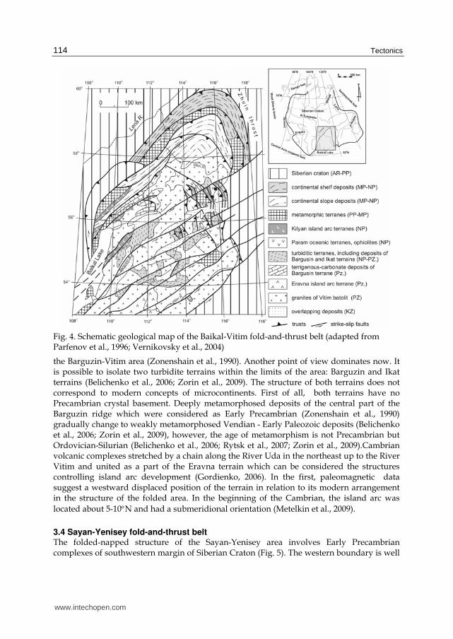
3.3 The Baikal-Vitim fold-and-thrust belt Geological complexes the Baikal-Vitim fold-and-thrust belt occupies an extensive territory to
the east from the Baikal Lake up to the Vitim river basin. We consider three tectonic
elements in its structure: the Bodajbo-Patom Neoproterozoic marginal-continental area; the
Baikal-Muya Neoproterozoic accretional belt; the Barguzin-Vitim Early Caledonian orogenic
area (Fig. 4).
3.3.1 Bodaibo-Patom area The area is characterized mainly by Neoproterozoic sedimentary successions. Sections are usually represented by terrigenous-carbonate deposits but their geodynamic position is interpreted differently (Nemerov & Stanevich, 2001; Pisarevsky & Natapov, 2003; Zorin et al., 2009). The absolute age of the majority of startigraphic units is also under discussion (Stanevich et al., 2007). Nevertheless, the general structural plan does not cause any doubts: the strata represent a thick sedimentary wedge, thickening toward the folded area and overlapping the crystal complexes of the craton margin. The change of shallow-water faces to more deep-water, flysch-like and turbidity deposits, follow the same direction. Such features are inherent in marginal-continental sea basins. Ophiolites and subduction complexes overthrusted on the margin of the craton from the south and comprising the Baikal-Muya belt can be considered as indicators of the Neoproterozoic ocean.
3.3.2 Baikal-Muya belt Three different units - the Muya cratonic terrain; Kilyan island arc terrain and Param oceanic terrain can be distinguished in the structure of the Neoproterozoic accretion belt (Parfenov et al., 1996; Khain, 2001). The most ancient ophiolite, according to Sm-Nd dates, correspond to the end of the Mesoproterozoic (Rytsk et al., 2001, 2007). The transformation of the continental margin into an active regime possibly occurred in the Middle Neoproterozoic 800-850 million years ago (Khain et al., 2003). Subductional volcano-plutonic associations are represented by the tuff and lava of rhyolite, andesite, basalt, and also gabbro and plagiogranite. The second peak of subduction magmatism corresponds to the interval 750-620 million years (Khain et al., 2003). However, according to some viewpoints the Kilyan island arc system was not connected directly with the margin of the Siberian Craton and the Baikal-Muya belt was a part of another superterrain, and has been developed far from the margin (Kuzmichev, 2005). Paleomagnetic data for this area are absent. It is supposed that just before the Vendian, the initial structure of the superterrain has been disrupted and the Bajkal-Muya fragment moved along the strike-slip and amalgamated to the Siberian Craton (Kuzmichev et al., 2005; Belichenko et al., 2006). The time of this event is supported by stratigraphic data. Acceretional complexes of the Baikal-Muya belt with angular and stratigraphic unconformity are overlapped by Vendian terrigenous deposits and Cambrian, predominantly carbonate deposits which have remained as isolated fragments and are probably the remains of former uniform sedimentary cover with Siberia (Belichenko et al., 2006).
3.3.3 Barguzin-Vitim area Traditionally it is considered that Late the Precambrian orogenesis resulted from the accretion process between the Siberian Craton and the Barguzin microcontinent. The remains of the microcontinent are expected to be to the south of the Baikal-Muya belt within
www.intechopen.com
Tectonics
114
Fig. 4. Schematic geological map of the Baikal-Vitim fold-and-thrust belt (adapted from Parfenov et al., 1996; Vernikovsky et al., 2004)
the Barguzin-Vitim area (Zonenshain et al., 1990). Another point of view dominates now. It is possible to isolate two turbidite terrains within the limits of the area: Barguzin and Ikat terrains (Belichenko et al., 2006; Zorin et al., 2009). The structure of both terrains does not correspond to modern concepts of microcontinents. First of all, both terrains have no Precambrian crystal basement. Deeply metamorphosed deposits of the central part of the Barguzin ridge which were considered as Early Precambrian (Zonenshain et al., 1990) gradually change to weakly metamorphosed Vendian - Early Paleozoic deposits (Belichenko et al., 2006; Zorin et al., 2009), however, the age of metamorphism is not Precambrian but Ordovician-Silurian (Belichenko et al., 2006; Rytsk et al., 2007; Zorin et al., 2009).Cambrian volcanic complexes stretched by a chain along the River Uda in the northeast up to the River Vitim and united as a part of the Eravna terrain which can be considered the structures controlling island arc development (Gordienko, 2006). In the first, paleomagnetic data suggest a westward displaced position of the terrain in relation to its modern arrangement in the structure of the folded area. In the beginning of the Cambrian, the island arc was
located about 5-10°N and had a submeridional orientation (Metelkin et al., 2009).
3.4 Sayan-Yenisey fold-and-thrust belt The folded-napped structure of the Sayan-Yenisey area involves Early Precambrian complexes of southwestern margin of Siberian Craton (Fig. 5). The western boundary is well
www.intechopen.com
Siberia - From Rodinia to Eurasia
115
pronounced in the strike-slip zone - a branch of the Main Sayan deep fault with immediately adjacent Caledonian structures of Altai-Sayan fragment of the Central-Asian orogenic belt which is plunging in the north under Mesozoic-Cenozoic cover of the West Siberian plate. The zone of the deep fault is well traced by geophysical data under the deposits of Western Siberia along the left bank of Yenisey River up to the Turukhansk-Norilsk area (Vernikovsky et al., 2009).
3.4.1 Paleoproterozoic terrains of the craton margins (the Angara belt) The structures of Sharyzhalgay and Birusa terrains constitute a distinct prominence of the
Siberian Craton. They are composed of granulite-gneiss and granite-greenschist type rocks
of the Archean-Paleoproterozoic age. Amalgamation of the terrains is associated with the
boundary of 1.8 - 1.9 billion years ago which is reflected in the formation of collisional
granites (Levitsky et al., 2002; Didenko et al., 2003; Turkina et al., 2007). Formation of similar
complexes is also detected in the north (Nozhkin et al., 1999) where Paleoproterozoc
structures are built up by granulite and amphibolites of the Angara-Kan terrain. It is
supposed that this stage of crustal growth has occurred over the whole western margin of
the Siberian Craton, and the resulting structure is united as a part of the Angara belt (Rozen,
2003). Further to the north, within the Yenisey range, the structure of the Angara belt is
represented by the East Angara terrain. In the limits of the terrain, Early Precambrian crystal
complexes are generally overlapped by low metamorphosed Mesoproterozoic and
Neoproterozoic terrigenous-carbonate strata. Among them, to the south, in the limits of Pre-
Sayan trough, deposits of the Karagas group are widespread. The group is characterized by
a cyclic-constructed succession which was deposited in the coastal-marine environment.
(Pisarevsky & Natapov, 2003; Stanevich et al., 2007; Metelkin et al., 2010b). The absolute age
of the strata is hotly debated. Considering the available stratigraphic constraints and the
indirect geochronological data, the group was deposited between 800 and 740 million years
ago (Stanevich et al., 2007). Paleomagnetic data suggest a Middle Neoproterozoic age of the
group and a high rate of its deposition (Metelkin et al., 2010b). Deposits of the Karagas
group and the underlying Paleoproterozoic metamorphic complexes are saturated by
subvolcanic intrusion of gabbro-dolerie, united in the Nersa complex. The age of that
complex is estimated as 740 million years, and it has been formed in conditions similar to
those of intercontinental riftogenesis (Sklyarov et al., 2003; Gladkochub et al., 2006). The
results of paleomagnetic study of the Nersa complex are given in (Metelkin et al., 2005a).
3.4.2 Central Angara belt The Central-Angara terrain occupies the central part of the Yenisey ridge. The structure of
its basement corresponds to Paleoproterozoic metamorphic terrains of the Angara belt. In
general, the Early Precambrian basement is overlaid by Mesoproterozoic and
Neoproterozoic coastal-marine sedimentary complexes. However, it is separated from the
East Angara terrain by the Panimba ophiolite belt accompanied with Ishimba thrust that
allows us to consider a tectonic history of the Central-Angara terrain separately from the
structures of the Angara belt. Argon-argon age of amphibolites and plagioclases from
gabbro-amphibolites of the ophiolite belt is 1050-900 million years (Vernikovsky et al., 2003).
Granitoids with 760-720 million years age appear to be indicators of a collisional event
(Vernikovsky et al., 2003; Vernikovskaya et al., 2003, 2006).
www.intechopen.com
Tectonics
116
Fig. 5. Geological sketch-map of the Sayan-Yenisey fold-and-thrust area (after Metelkin et al., 2007a)
3.4.3 Pie-Yenisey accretional belt The western periphery of the Yenisey ridge is occupied by Neoproterozoic accretional structures napped over crystal formations of the Central-Angara and Angara-Kan terrains. Isakov and Predivinsk island arc terrains can be distinguished in the area (Vernikovsky et al., 2003). Structures of the terrains contain subductional volcano-sedimentary complexes
www.intechopen.com
Siberia - From Rodinia to Eurasia
117
including ophiolite fragments, partly metamorphosed in green-schist conditions (Vernikovsky et al., 1999). Results of U-Pb, Ar-Ar, and Rb-Sr isotope study allow an estimate of the evolution time of an active volcanic arc between 700 and 640 million years ago, and the time of accretion as 600 million years ago (Vernikovsky et al., 2003). The time of accretion coordinates well with the Vendian age of overlapping molasse (Sovetov et al., 2000). A paleomagnetic study was carried out on the volcanic complexes of differentiated calc-alkaline series of the Predivinsk terrain with a U-Pb age 637± 5.7 million years ago (Metelkin et al., 2004а). Paleomagnetic pole positions correspond to the general trend of Vendian poles of Siberia (Pisarevsky al., 2000; Kravchinsky et al., 2001; Kazansky, 2002; Shatsillo et al., 2005, 2006). Taking into account that the development of the series has proceeded directly before accretion, the paleomagnetic data allows estimation of a spatial position not only for the arcs, but also as a first approximation for the craton (Metelkin et al., 2004а; Vernikovsky et al., 2009).
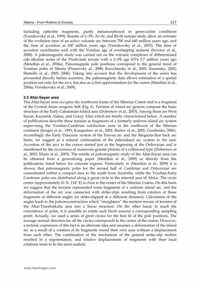
3.5 Altai-Sayan area The Altai-Sayan area occupies the southwest frame of the Siberian Craton and is a fragment
of the Central-Asian orogenic belt (Fig. 6). Terrains of island arc genesis compose the basic
structure of the Early Caledonian folded area (Dobretsov et al., 2003). Among them are West
Sayan, Kuznetsk Alatau, and Gorny Altai which are briefly characterized below. A number
of publications describe these terrains as fragments of a formerly uniform island arc system
supervising the Vendian-Cambrian subduction zone in the southwest of the Siberian
continent (Нengör et al., 1993; Kungurtsev et al., 2001; Buslov et al., 2001; Gordienko, 2006).
Accordingly the Early Paleozoic system of the Eravna arc and the Barguzin-Ikat back arc
basin, we suggest as a natural continuation of the paleoisland arc system to the east.
Accretion of the arcs to the craton started just at the beginning of the Ordovician and is
manifested by the occurrence of numerous granite plutons of a collisional type (Dobretsov et
al., 2003; Khain et al., 2003). The results of paleomagnetic study of the Altai-Sayan area can
be obtained from a generalizing paper (Metelkin et al., 2009) or directly from the
publications listed below for concrete regions. Particularly in (Metelkin et al., 2009) it is
shown, that paleomagnetic poles for the second half of Cambrian and Ordovician are
concentrated within a compact area to the south from Australia, while the Vendian-Early
Cambrian poles are distributed along a great circle in the internal area of Africa. The circle
center (approximately 61 N, 114° E) is close to the center of the Siberian Craton. On this basis
we suggest that the terrains represented some fragments of a uniform island arc, and the
deformation of the arc was connected with strike-slips resulting from rotation of those
fragments at different angles (or strike-slipped at a different distance). Calculation of the
angles leads to the paleoreconstruction which “straightens” the modern mosaic of terrains of
the Altai-Transbaikalia area into a linear structure. On the other hand, to reach the
coincidence of poles, it is possible to rotate each block around a corresponding sampling
point. Actually, we used a series of great circles for the best fit of the pole positions. The
average normal direction for all the circles corresponds to the center of the craton. However,
a tectonic expression of this fact is an alternate idea and assumes a deformation of the island
arc as a result of a rotation of its fragments round their own axes without a displacement
from each other. The combination of the mechanism of the general strike-slip motion
resulted in a segmentation, and relative displacements of fragments with their local
rotations seem to be the most realistic.
www.intechopen.com
Tectonics
118
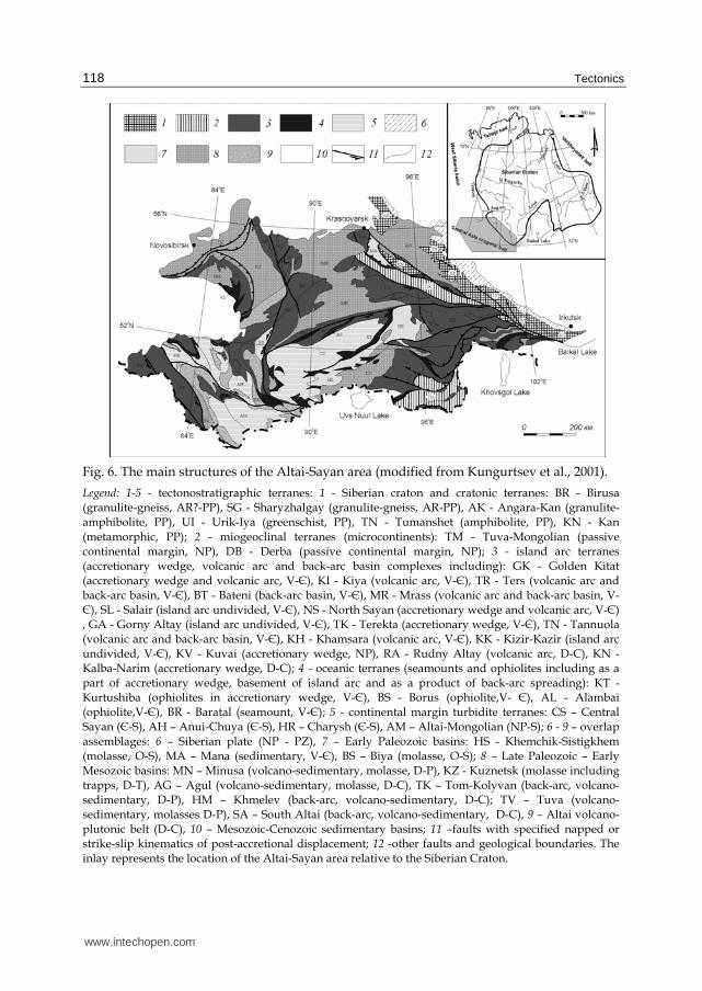
Fig. 6. The main structures of the Altai-Sayan area (modified from Kungurtsev et al., 2001).
Legend: 1-5 - tectonostratigraphic terranes: 1 - Siberian craton and cratonic terranes: BR - Birusa (granulite-gneiss, AR?-PP), SG - Sharyzhalgay (granulite-gneiss, AR-PP), AK - Angara-Kan (granulite-amphibolite, PP), UI - Urik-Iya (greenschist, PP), TN - Tumanshet (amphibolite, PP), KN - Kan
(metamorphic, PP); 2 - miogeoclinal terranes (microcontinents): TM - Tuva-Mongolian (passive continental margin, NP), DB - Derba (passive continental margin, NP); 3 - island arc terranes (accretionary wedge, volcanic arc and back-arc basin complexes including): GK - Golden Kitat (accretionary wedge and volcanic arc, V-Є), KI - Kiya (volcanic arc, V-Є), TR - Ters (volcanic arc and back-arc basin, V-Є), BT - Bateni (back-arc basin, V-Є), MR - Mrass (volcanic arc and back-arc basin, V-Є), SL - Salair (island arc undivided, V-Є), NS - North Sayan (accretionary wedge and volcanic arc, V-Є) , GA - Gorny Altay (island arc undivided, V-Є), TK - Terekta (accretionary wedge, V-Є), TN - Tannuola (volcanic arc and back-arc basin, V-Є), KH - Khamsara (volcanic arc, V-Є), KK - Kizir-Kazir (island arc undivided, V-Є), KV - Kuvai (accretionary wedge, NP), RA - Rudny Altay (volcanic arc, D-C), KN - Kalba-Narim (accretionary wedge, D-C); 4 - oceanic terranes (seamounts and ophiolites including as a part of accretionary wedge, basement of island arc and аs a product of back-arc spreading): KT - Kurtushiba (ophiolites in accretionary wedge, V-Є), BS - Borus (ophiolite,V- Є), AL - Alambai (ophiolite,V-Є), BR - Baratal (seamount, V-Є); 5 - continental margin turbidite terranes: CS – Central Sayan (Є-S), AH – Аnui-Chuya (Є-S), HR – Charysh (Є-S), AM – Altai-Mongolian (NP-S); 6 - 9 – overlap
assemblages: 6 – Siberian plate (NP - PZ), 7 – Early Paleozoic basins: HS - Khemchik-Sistigkhem (molasse, 《-S), MA – Mana (sedimentary, V-Є), BS – Biya (molasse, 《-S); 8 – Late Paleozoic – Early Mesozoic basins: MN – Minusa (volcano-sedimentary, molasse, D-P), KZ - Kuznetsk (molasse including trapps, D-T), AG – Agul (volcano-sedimentary, molasse, D-C), TK – Tom-Kolyvan (back-arc, volcano-sedimentary, D-P), HM – Khmelev (back-arc, volcano-sedimentary, D-С); TV – Tuva (volcano-sedimentary, molasses D-P), SA – South Altai (back-arc, volcano-sedimentary, D-С), 9 – Altai volcano-plutonic belt (D-С), 10 – Mesozoic-Cenozoic sedimentary basins; 11 –faults with specified napped or strike-slip kinematics of post-accretional displacement; 12 -other faults and geological boundaries. The inlay represents the location of the Altai-Sayan area relative to the Siberian Craton.
www.intechopen.com
Siberia - From Rodinia to Eurasia
119
3.5.1 West Sayan terrain The West Sayan terrain includes the Vendian-Cambrian complexes of the island arch which are composed of two large fragments. In the frontal part of North Sayan fragment the complexes of the accretionry wedge are represented by terrigenous deposits interbeded with basalt, tuff, marble, and also ophiolite units. The lateral succession to the north is supplemented by turbidities and then by complexes of the volcanic arc. The Vendian-Early Cambrian interval is characterized by tholiite magmatism which was replaced by a differentiated series at the boundary of 520 million years ago. This complex is overlapped by a multicolored terrigenous sequence formed as a result of an intensive washing of the volcanic series. The Kurtushiba fragment corresponds to the frontal part of the arc with widespread oceanic complexes. A paleomagnetic study of the above named complexes proves the preservation of a stable magnetic component which was acquired at the stage of rock formation (Kazansky et al., 1999). Generalization of the data reveals the following tectonic history of the terrain. Both fragments belonged to the uniform arc occupied in the subequatorial position in the Cambrian. The arc has undergone a prevailing submerideonal drift and strike-slip displacement of the Kurtushiba fragment to the southwest, in relation to the North Sayan (Metelkin et al., 2009).
3.5.2 Kuznetsk Alatau terrain The Kuznetsk Alatau terrain consists of five units which possess the original tectonic style,
but undoubtedly are fragments of the uniform paleoisland arc system (Metelkin et al., 2000;
Kazansky et al., 2003). We studied four of them: Golden Kitat, Kiya, Ters and Bateni tectonic
units, mainly composed of Cambrian subduction complexes with a typical set of rock
associations.
The Vendian-Early Cambrian complex is represented by the tholeite series, the Middle-Late
Cambrian complex is represented by a differentiated series with an expressed calc-alkaline
composition and considerable concentration of pyroclasics. The development of the Late
Cambrian-Early Ordovician molasse and alkaline volcano-plutonic complex corresponds to
an accretion stage. The ages are proved by the isotope data (Vladimirov et al., 2001).
Paleomagnetic data (Metelkin et al., 2000; Kazansky et al., 2003) shows that the structural
plan of the region is determined by the strike-slip motions of its fragments. Analysis of APW
trends (Kazansky et al., 2003; Metelkin & Koz’min, in progress) allows restoration of a
southern drift of the arc with a 5-6 cm/year velocity which was accompanied by a clockwise
rotation. The size of displacement of the forearc and back-arc parts were different which
caused the strike-slip mechanism of transformation of the initial structure of the arc. The
reconstructed position of the arc in the Cambrian corresponds to subequatorial latitudes.
3.5.3 Gorny Altai terrain. The Gorny Altai terrain stands out because of its repeated alternation of blocks composed of island arc complexes, resulting from strike-slip tectonics which manifested both during Early Caledonian and Hercinian stages of the orogenesis (Buslov et al., 2003). The western part (the Anui-Chuya trough) is represented by terrigenous complexes of forearc basin with characteristic flysch and olistostrome composition. Complexes of accretionary wedge and volcanic arc are predominant in the central part. The basalts are typical representatives of the Kuray zone where the Vendian-Early Cambrian spreading and subduction complexes are widespread. The accretionary wedge is mainly composed of carbonate deposits
www.intechopen.com
Tectonics
120
overlapping pillow-basalts which are considered as seamounts (Safonova et al., 2008). The collision of the seamounts with the island arc occurred 520 million years ago, marking the beginning of the developed stage of subduction magmatism (Buslov et al., 2001). Typical calc-alkaline complexes of Middle-Late Cambrian are distributed in the east in the Ujmen-Lebed zone and volcano-sedimentary sequences of the back-arc basin are also present here. Paleomagnetic data (Pechersky & Didenko, 1995; Kazansky et al., 1998; Kazansky, 2002) testify that the Gorny Altai terrain constitutes a part of the Kuznetsk Alatau island arc and the transformation of its initial structure may be described by the same uniform strike-slip mechanism (Metelkin et al., 2009).
4. The tectonic and paleogeographical reconstructions of Siberia and surrounding terrains
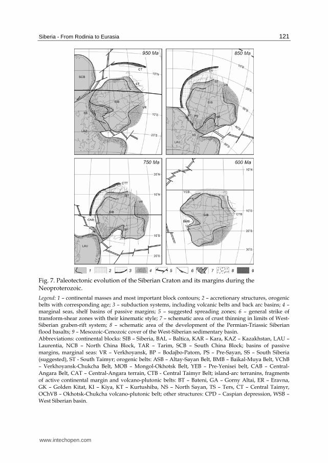
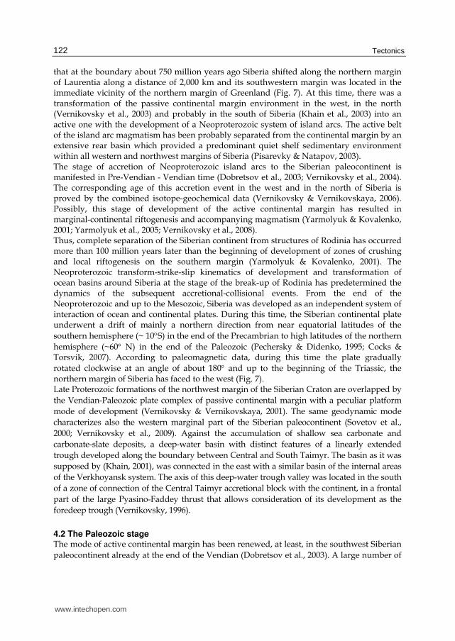
4.1 The Neoproterozoic stage The history of the Siberian paleocontinent actually begins at the moment of Rodinia break-up. The Neoproterozoic stage of tectonic history corresponds to this event (Li et al., 2008). The set of available geological and paleomagnetic data testifies that at the Mesoproterozoic-Neoproterozoic boundary the Siberian Craton was a part of Rodinia and could represent a large peninsula of the supercontinent in the northeast (Metelkin et al., 2007а; Pisarevsky et al., 2008). In modern co-ordinates, Siberia continued as Laurentia to the north so that the western margin of Siberia was a continuation of the western margin of Laurentia (Fig. 7). The review of geological data on structural position, structure, formation environments and age of the Late Mesoproterozoic and Early Neoproterozoic complexes distributed on the margins of the Siberian Craton shows that this stage of geological history practically in all the periphery of the continent is connected with the dominating conditions of a continental shelf (Pisarevsky & Natapov, 2003; Pisarevsky et al., 2008). The modern northwest margin of Siberia, also as the western and the eastern margins (Semikhatov et al., 2000; Petrov & Semikhatov, 2001), represented a passive continental margin with a typical complex of sedimentary rocks (Pisarevsky & Natapov, 2003). An active tectonic mode, possibly characterizes only the southern margin of Siberia (Rainbird et al., 1998; Pavlov et al., 2002; Yarmolyuk et al., 2005; Metelkin et al., 2007а). Geological complexes in this area can correspond to the mode of intracontinent riftung or an active stage of the development of the ocean. Among them dikes with an age of 950-1000 million years (Rainbird et al., 1998; Pavlov et al., 2002) in the sedimentary cover of Uchur-Maya region in the southeast of the craton, geological complexes of various geodynamic environments of the Baikal-Muya accretion system (Parfenovet al., 1996; Khain et al., 2003; Gordienko, 2006), the youngest at about 750 million years and younger and products of intraplate alkaline magmatism in Pre-Sayan and Baikal regions in the southwest of the craton (Yarmolyuk et al., 2005; Gladkochub et al., 2006) can be distinguished. Thus, the gradual rejuvenation of magmatism due to available isotope data is assumed to be from the east to the west. On the basis of a number of petrologic-geochemical evidences the direct link between the development of intrusive massifs subvolcanic intrusions of the basic composition with rifting processes, and the break-up of the Laurasian part of Rodinia is assumed (Yarmolyuk et al., 2005, Pisarevsky et al., 2008). Paleomagnetic data suggest that break-up of the continental masses of Siberia and Laurentia during the Neoproterozoic passed gradually along the southern margin of Siberia from the east to the west under the defining role of strike-slips which have set the rotary motion to the Siberian Craton (Metelkin et al., 2007а). Following this model, it was possible to believe
www.intechopen.com
Siberia - From Rodinia to Eurasia
121
Fig. 7. Paleotectonic evolution of the Siberian Craton and its margins during the Neoproterozoic.
Legend: 1 – continental masses and most important block contours; 2 – accretionary structures, orogenic belts with corresponding age; 3 – subduction systems, including volcanic belts and back arc basins; 4 – marginal seas, shelf basins of passive margins; 5 – suggested spreading zones; 6 – general strike of transform-shear zones with their kinematic style; 7 – schematic area of crust thinning in limits of West-Siberian graben-rift system; 8 – schematic area of the development of the Permian-Triassic Siberian flood basalts; 9 – Mesozoic-Cenozoic cover of the West-Siberian sedimentary basin. Abbreviations: continental blocks: SIB – Siberia, BAL – Baltica, KAR – Kara, KAZ – Kazakhstan, LAU –
Laurentia, NCB – North China Block, TAR – Tarim, SCB – South China Block; basins of passive
margins, marginal seas: VR – Verkhoyansk, BP – Bodajbo-Patom, PS – Pre-Sayan, SS – South Siberia
(suggested), ST - South Taimyr; orogenic belts: ASB – Altay-Sayan Belt, BMB – Baikal-Muya Belt, VChB
– Verkhoyansk-Chukcha Belt, MOB – Mongol-Okhotsk Belt, YEB – Pre-Yenisei belt, CAB – Central-
Angara Belt, CAT – Central-Angara terrain, CTB - Central Taimyr Belt; island-arc terranins, fragments
of active continental margin and volcano-plutonic belts: BT – Bateni, GA – Gorny Altai, ER – Eravna,
GK – Golden Kitat, KI – Kiya, KT – Kurtushiba, NS – North Sayan, TS – Ters, CT – Central Taimyr,
OChVB – 《khotsk-Chukcha volcano-plutonic belt; other structures: CPD – Caspian depression, WSB –
West Siberian basin.
www.intechopen.com
Tectonics
122
that at the boundary about 750 million years ago Siberia shifted along the northern margin of Laurentia along a distance of 2,000 km and its southwestern margin was located in the immediate vicinity of the northern margin of Greenland (Fig. 7). At this time, there was a transformation of the passive continental margin environment in the west, in the north (Vernikovsky et al., 2003) and probably in the south of Siberia (Khain et al., 2003) into an active one with the development of a Neoproterozoic system of island arcs. The active belt of the island arc magmatism has been probably separated from the continental margin by an extensive rear basin which provided a predominant quiet shelf sedimentary environment within all western and northwest margins of Siberia (Pisarevky & Natapov, 2003). The stage of accretion of Neoproterozoic island arcs to the Siberian paleocontinent is manifested in Pre-Vendian - Vendian time (Dobretsov et al., 2003; Vernikovsky et al., 2004). The corresponding age of this accretion event in the west and in the north of Siberia is proved by the combined isotope-geochemical data (Vernikovsky & Vernikovskaya, 2006). Possibly, this stage of development of the active continental margin has resulted in marginal-continental riftogenesis and accompanying magmatism (Yarmolyuk & Kovalenko, 2001; Yarmolyuk et al., 2005; Vernikovsky et al., 2008). Thus, complete separation of the Siberian continent from structures of Rodinia has occurred more than 100 million years later than the beginning of development of zones of crushing and local riftogenesis on the southern margin (Yarmolyuk & Kovalenko, 2001). The Neoproterozoic transform-strike-slip kinematics of development and transformation of ocean basins around Siberia at the stage of the break-up of Rodinia has predetermined the dynamics of the subsequent accretional-collisional events. From the end of the Neoproterozoic and up to the Mesozoic, Siberia was developed as an independent system of interaction of ocean and continental plates. During this time, the Siberian continental plate underwent a drift of mainly a northern direction from near equatorial latitudes of the
southern hemisphere (~ 10°S) in the end of the Precambrian to high latitudes of the northern
hemisphere (~60° N) in the end of the Paleozoic (Pechersky & Didenko, 1995; Cocks & Torsvik, 2007). According to paleomagnetic data, during this time the plate gradually
rotated clockwise at an angle of about 180° and up to the beginning of the Triassic, the northern margin of Siberia has faced to the west (Fig. 7). Late Proterozoic formations of the northwest margin of the Siberian Craton are overlapped by
the Vendian-Paleozoic plate complex of passive continental margin with a peculiar platform
mode of development (Vernikovsky & Vernikovskaya, 2001). The same geodynamic mode
characterizes also the western marginal part of the Siberian paleocontinent (Sovetov et al.,
2000; Vernikovsky et al., 2009). Against the accumulation of shallow sea carbonate and
carbonate-slate deposits, a deep-water basin with distinct features of a linearly extended
trough developed along the boundary between Central and South Taimyr. The basin as it was
supposed by (Khain, 2001), was connected in the east with a similar basin of the internal areas
of the Verkhoyansk system. The axis of this deep-water trough valley was located in the south
of a zone of connection of the Central Taimyr accretional block with the continent, in a frontal
part of the large Pyasino-Faddey thrust that allows consideration of its development as the
foredeep trough (Vernikovsky, 1996).
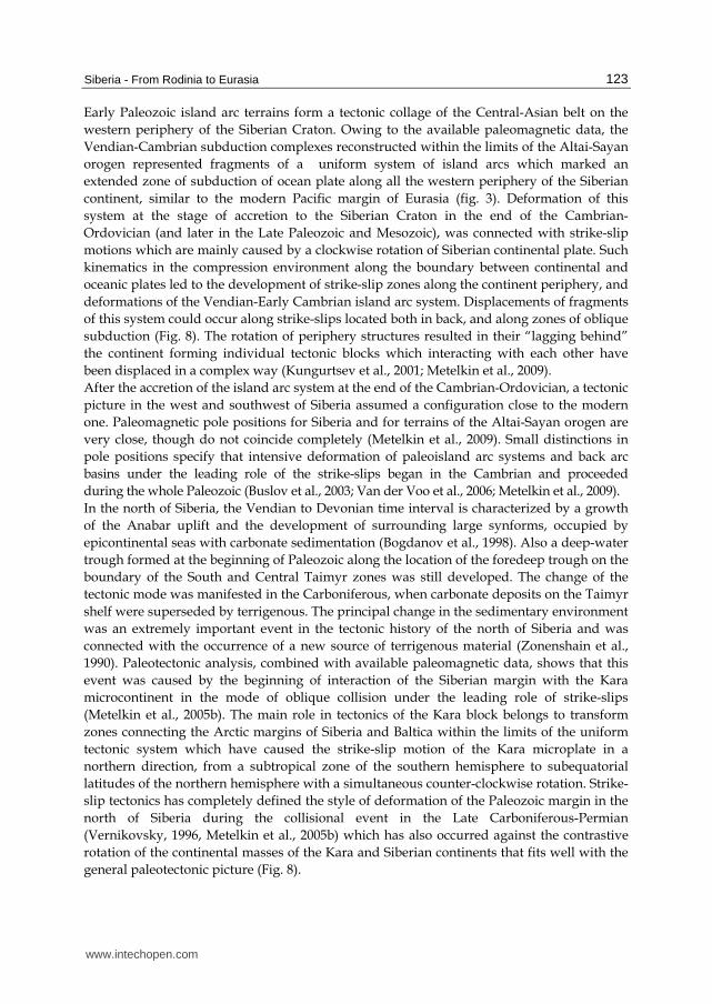
4.2 The Paleozoic stage The mode of active continental margin has been renewed, at least, in the southwest Siberian
paleocontinent already at the end of the Vendian (Dobretsov et al., 2003). A large number of
www.intechopen.com
Siberia - From Rodinia to Eurasia
123
Early Paleozoic island arc terrains form a tectonic collage of the Central-Asian belt on the
western periphery of the Siberian Craton. Owing to the available paleomagnetic data, the
Vendian-Cambrian subduction complexes reconstructed within the limits of the Altai-Sayan
orogen represented fragments of a uniform system of island arcs which marked an
extended zone of subduction of ocean plate along all the western periphery of the Siberian
continent, similar to the modern Pacific margin of Eurasia (fig. 3). Deformation of this
system at the stage of accretion to the Siberian Craton in the end of the Cambrian-
Ordovician (and later in the Late Paleozoic and Mesozoic), was connected with strike-slip
motions which are mainly caused by a clockwise rotation of Siberian continental plate. Such
kinematics in the compression environment along the boundary between continental and
oceanic plates led to the development of strike-slip zones along the continent periphery, and
deformations of the Vendian-Early Cambrian island arc system. Displacements of fragments
of this system could occur along strike-slips located both in back, and along zones of oblique
subduction (Fig. 8). The rotation of periphery structures resulted in their “lagging behind”
the continent forming individual tectonic blocks which interacting with each other have
been displaced in a complex way (Kungurtsev et al., 2001; Metelkin et al., 2009).
After the accretion of the island arc system at the end of the Cambrian-Ordovician, a tectonic
picture in the west and southwest of Siberia assumed a configuration close to the modern
one. Paleomagnetic pole positions for Siberia and for terrains of the Altai-Sayan orogen are
very close, though do not coincide completely (Metelkin et al., 2009). Small distinctions in
pole positions specify that intensive deformation of paleoisland arc systems and back arc
basins under the leading role of the strike-slips began in the Cambrian and proceeded
during the whole Paleozoic (Buslov et al., 2003; Van der Voo et al., 2006; Metelkin et al., 2009).
In the north of Siberia, the Vendian to Devonian time interval is characterized by a growth
of the Anabar uplift and the development of surrounding large synforms, occupied by
epicontinental seas with carbonate sedimentation (Bogdanov et al., 1998). Also a deep-water
trough formed at the beginning of Paleozoic along the location of the foredeep trough on the
boundary of the South and Central Taimyr zones was still developed. The change of the
tectonic mode was manifested in the Carboniferous, when carbonate deposits on the Taimyr
shelf were superseded by terrigenous. The principal change in the sedimentary environment
was an extremely important event in the tectonic history of the north of Siberia and was
connected with the occurrence of a new source of terrigenous material (Zonenshain et al.,
1990). Paleotectonic analysis, combined with available paleomagnetic data, shows that this
event was caused by the beginning of interaction of the Siberian margin with the Kara
microcontinent in the mode of oblique collision under the leading role of strike-slips
(Metelkin et al., 2005b). The main role in tectonics of the Kara block belongs to transform
zones connecting the Arctic margins of Siberia and Baltica within the limits of the uniform
tectonic system which have caused the strike-slip motion of the Kara microplate in a
northern direction, from a subtropical zone of the southern hemisphere to subequatorial
latitudes of the northern hemisphere with a simultaneous counter-clockwise rotation. Strike-
slip tectonics has completely defined the style of deformation of the Paleozoic margin in the
north of Siberia during the collisional event in the Late Carboniferous-Permian
(Vernikovsky, 1996, Metelkin et al., 2005b) which has also occurred against the contrastive
rotation of the continental masses of the Kara and Siberian continents that fits well with the
general paleotectonic picture (Fig. 8).
www.intechopen.com
Tectonics
124
Fig. 8. Paleotectonic evolution of the Siberian Craton and its margins during the Paleozoic. For legend and abbreviations see Fig. 7.
A certain problem is represented by the absence of Paleozoic subduction complexes, which should be located within the Major Taimyr suture, if we assume a space with oceanic crust between Siberia and Kara. The obvious explanation, following from the proposed model, is a soft interaction of sialic masses with the predominating role of strike-slips, under conditions of oblique transform rapprochement and the subsequent collision. The final
www.intechopen.com
Siberia - From Rodinia to Eurasia
125
stages of the orogen the development at the Permian-Triassic boundary have led to development of large extension zones in the frontal part of the Taimyr folded structures and have predetermined the development of a large depression - the Yenisey-Khatanga trough in this segment of the belt.
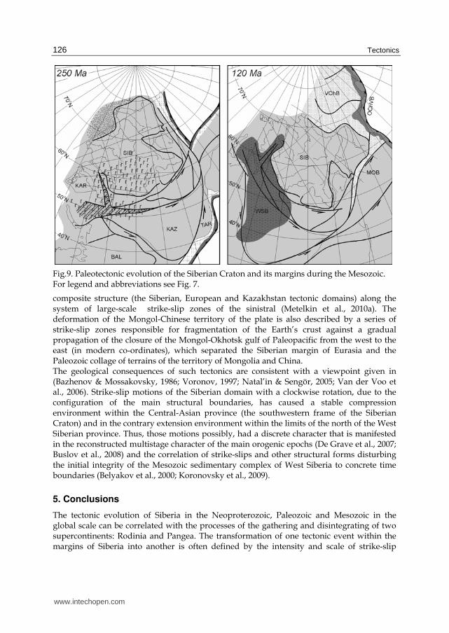
4.3 The Mesozoic stage Intracontinental rifting on the Permian-Triassic boundary is well pronounced in Western Siberia. Not only the folded-napped structure of Taimyr-Severnaya Zemlya area was formed up to the beginning of this stage. The closing of the Precambrian-Early Paleozoic oceans resulted in the general structure of the Central-Asian belt sewing the continental masses of the Siberian and East European cratons into a uniform Eurasian plate, which in turn has comprised the basic structure of the Laurasian part of Pangea. This key moment in the tectonic history of Siberia is marked by a giant trapp magmatic event, connected with the activity of the largest mantle plum (Dobretsov, 2005). Within the limits of Siberian platform, flood basalts are concentrated in the Tungus syneclise and continued under the Yenisey-Khatanga trough to South Taimyr. To the west, within the West Siberian plate, trapp basalts were found under the Mesozoic-Cenozoic cover of deposits and traced up to the East Ural trough. As a rule they distributed along rift zones of the Koltogor-Urengoy graben but also exposed in boreholes between rifts. Fields of flood basalts are stretched to the north, covering the bottoms of the Kara and Barents seas (Dobretsov & Vernikovsky, 2001; Dobretsov, 2005). The most southern satellite of Siberian trapps is present in the structure of the Kuznetsk trough (Dobretsov, 2005; Kazansky et al., 2005). Correlations on the basis of available paleomagntic and geochronological data testify that the development of the Siberian trapp province occurred extremely quickly. The duration of intensive magmatism in the different areas is estimated from 1 to 5 million years (Dobretsov, 2005; Kazansky et al., 2005).The magmatism was controlled in the south (the Kuznetsk trough), possibly in the west (West Siberia) and in the north (Yenisey-Khatanga trough), by large scale strike-slips (Fig. 9). Analysis of paleomagnetic data for the Permian-Triassic boundary gives ground to the assertion that intraplate strike-slip deformation caused by a clockwise rotation of the Siberian tectonic domain of the Eurasian plate, appear to be a possible reason for the generation of submeridional systems of graben structures in the basement of West Siberia which resulted in the development of a large Mesozoic-Cenozoic sedimentary basin (Bazhenov & Mossakovsky, 1986; Voronov, 1997). The east branch of this strike-slip system which caused riftogenesis in West Siberia is an extension connected with the frontal thrust structures of Taimyr. The axial graben of the Yenisey-Khatanga trough and the single age Koltogor-Urengoy graben-rift system (Khain, 2001) form a resemblance to a triple junction that fits the strike-slip model. Essential deformations in the compression environment, shown in the southwest of Siberia, within the limits of the Altai-Sayan folded area are correlated with the same strike-slip tectonics caused by a rotation of the Siberian domain of the Eurasian plate relative to the European one (Bazhenov & Mossakovsky, 1986; Metelkin et al., 2010a). Strike-slip motions of the described kinematics in the Eurasian continent proceeded up to the end of the Mesozoic (Fig. 9) which is supported by a regular deviation in Mesozoic positions for Siberia and Eastern Europe (Metelkin et al., 2010a). Thus, the crust deformation of the Central Asia in the Mesozoic, against the general clockwise rotation of the Eurasian plate as is shown in reconstruction (Fig. 9), is connected with the motions of separate components of its
www.intechopen.com
Tectonics
126
Fig.9. Paleotectonic evolution of the Siberian Craton and its margins during the Mesozoic. For legend and abbreviations see Fig. 7.
composite structure (the Siberian, European and Kazakhstan tectonic domains) along the system of large-scale strike-slip zones of the sinistral (Metelkin et al., 2010a). The deformation of the Mongol-Chinese territory of the plate is also described by a series of strike-slip zones responsible for fragmentation of the Earth’s crust against a gradual propagation of the closure of the Mongol-Okhotsk gulf of Paleopacific from the west to the east (in modern co-ordinates), which separated the Siberian margin of Eurasia and the Paleozoic collage of terrains of the territory of Mongolia and China. The geological consequences of such tectonics are consistent with a viewpoint given in (Bazhenov & Mossakovsky, 1986; Voronov, 1997; Natal’in & Sengör, 2005; Van der Voo et al., 2006). Strike-slip motions of the Siberian domain with a clockwise rotation, due to the configuration of the main structural boundaries, has caused a stable compression environment within the Central-Asian province (the southwestern frame of the Siberian Craton) and in the contrary extension environment within the limits of the north of the West Siberian province. Thus, those motions possibly, had a discrete character that is manifested in the reconstructed multistage character of the main orogenic epochs (De Grave et al., 2007; Buslov et al., 2008) and the correlation of strike-slips and other structural forms disturbing the initial integrity of the Mesozoic sedimentary complex of West Siberia to concrete time boundaries (Belyakov et al., 2000; Koronovsky et al., 2009).
5. Conclusions
The tectonic evolution of Siberia in the Neoproterozoic, Paleozoic and Mesozoic in the global scale can be correlated with the processes of the gathering and disintegrating of two supercontinents: Rodinia and Pangea. The transformation of one tectonic event within the margins of Siberia into another is often defined by the intensity and scale of strike-slip
www.intechopen.com
Siberia - From Rodinia to Eurasia
127
motions. The processes of strike-slip tectonics are presented practically everywhere and in all intervals of geological history of the Siberian plate. They defined the tectonic style of the evolution of the structures of the Siberian region in the early stages of development of the ocean basins, as well as during the active subduction of the oceanic crust and undoubtedly, at the accretion-collision stage. Intraplate deformations of the continental crust, accompanied with active magmatism, were also governed by strike-slip motions of fragments of different sizes. It is an important concept that reconstructed strike-slip zones very largely extended and as a rule correspond to the boundaries of the main tectonic elements that is they are connected with processes of at least regional, and more often of planetary scale.
6. References
Bazhenov, M.L. & Mossakovsky, A.A. (1986). Horizontal movements of the Siberian Platform in the Triassic: paleomagnetic and geological evidence, Geotektonika, No.1, 59–69, ISSN 0016-8521, (in Russian)
Belichenko, V.G.; Geletii, N.K. & Barash, I.G. (2006). Barguzin microcontinent (Baikal mountain area): the problem of outlining, Russ. Geol. Geophys., Vol.47, No.10, 1035-1045, ISSN 1068-7971
Belyakov, S.L.; Bondarenko, G.E.; Ivanyuk, V.V. & Smirnov, A.V. (2000). New Data on Late Mesozoic Strike-Slip Deformations in Sedimentary Cover of the Northern Sector of the West Siberian Plate, Dokl. Earth Sci., Vol.372, No.4, 646-649, ISSN 1028-334X
Berzin, N.A.; Coleman, R.G.; Dobretsov, N.L.; Zonenshain, L.P.; Xiao, X.C. & Chang, E.Z. (1994). Geodynamic map of the western Palaeoasian ocean, Russ. Geol. Geophys., Vol.35, No.7–8, 8–28, ISSN 1068-7971
Besse, J. & Courtillot, V. (2002). Apparent and true polar wander and geometry of the geomagnetic field over the last 200 Myr, J. Geoph. Res., Vol.107, No.B11, 1–31, ISSN 0148-0227
Bogdanov, N.A.; Khain, V.E.; Rosen, O.M.; Shipilov, E.V.; Vernikovsky, V.A.; Drachev, S.S. & Kostyuchenko, S.H. (1998). Tectonic Map of the Kara and Laptev Seas and North Siberia (scale 1:2,500,000), Explanatory notes, Inst. Lithosphere of Marginal Seas, Moscow
Bogolepova O.K.; Gubanov A.P. & Raevskaya E.G. (2001). The Cambrian of the Severnaya Zemlya archipelago, Russia, Newsl. Stratigr., Vol.39, 73–91, ISSN 0078-0421
Buslov, M.M.; Saphonova, I.Yu.; Watanabe, T.; Obut, O.T.; Fujiwara, Y.; Iwata, K.; Semakov, N.N.; Sugai, Y.; Smirnova, L.V. & Kazansky, A.Yu. (2001). Evolution of the Paleo-Asian Ocean (Altai-Sayan Region, Central Asia) and collision of possible Gondwana-derived terranes with the southern marginal part of the Siberian, Geosci. J., Vol.5, No.3, 203–224, ISSN 1226-4806
Buslov, M.M.; Watanabe, T.; Smirnova, L.V.; Fujiwara, I.; Iwata, K.; De Grave, J.; Semakov, N.N.; Travin, A.V.; Kir'yanova, A.P. & Kokh, D.A. (2003). Role of strike-slip faults in Late Paleozoic-Early Mesozoic tectonics and geodynamics of the Altai-Sayan and East Kazakhstan folded zone, Russ. Geol. Geophys., Vol.44, No.1-2, 49-75, ISSN 1068-7971
Buslov, M.M.; Kokh, D.A. & De Grave, J. (2008). Mesozoic-Cenozoic tectonics and geodynamics of Altai, Tien Shan, and Northern Kazakhstan, from apatite fission-track data, Russ. Geol. Geophys., Vol.49, No.9, 648-654, ISSN 1068-7971
www.intechopen.com
Tectonics
128
Cocks, L.R.M. & Torsvik, T.H. (2007). Siberia, the wandering northern terrane, and its changing geography through the Palaeozoic, Earth Sci. Rev., Vol.82, 29–74, ISSN 0012-8252
Cogné, J.-P.; Kravchinsky, V.A.; Halim, N. & Hankard, F. (2005). Late Jurassic – Early Cretaceous closure of the Mongol-Okhotsk Ocean demonstrated by new Mesozoic palaeomagnetic results from the Trans-Baikal area (SE Siberia), Geophys. J. Int., Vol.163, 813–832, ISSN 0956-540X
De Grave, J.; Buslov, M.M. & Van den haute, P. (2007). Distant effects of India–Eurasia convergence and Mesozoic intracontinental deformation in Central Asia: Constraints from apatite fission-track thermochronology, J. Asian Earth Sci., Vol.29, 194–213, ISSN 1367-9120
Didenko, A.N.; Kozakov, I.K.; Bibikova, E.V.; Vodovozov, V.Yu.; Khil’tova, V.Ya.; Reznitskii, L.Z.; Ivanov, A.V.; Levitskii, V.I.; Travin, A.V.; Shevchenko, D.O. & Rasskazov S.V. (2003). Paleoproterozoic Granites of the Sharyzhalgai Block, Siberian Craton: Paleomagnetism and Geodynamic Inferences, Dokl. Earth Sci., Vol.390, No.4, 510–515, ISSN 1028-334X
Dobretsov, N.L. (2005). 250 Ma large igneous provinces of Asia: Siberian and Emeishan traps (plateau basalts) and associated granitoids, Russ. Geol. Geophys., Vol.46, No.9, 847-868, ISSN 1068-7971
Dobretsov, N.L. & Vernikovsky, V.A. (2001). Mantle plumes and their geological manifestations, Int. Geol. Rev., Vol.43, 771–787, ISSN 0020-6814
Dobretsov, N.L.; Buslov, M.M. & Vernikovsky, V.A. (2003). Neoproterozoic to Early Ordovician Evolution of the Paleo-Asian Ocean: Implications to the Break-up of Rodinia, Gondwana Res., Vol.6, No.2, 143-159, ISSN 1342-937X
Gallet, Y.; Pavlov, V.E.; Semikhatov, M.A. & Petrov, P.Y. (2000). Late Mesoproterozoic magnetostratigraphic results from Siberia: paleogeographic implications and magnetic field behavior, J. Geоphys. Res., Vol.105, 16481-16499, ISSN 0148-0227
Gladkochub, D.P.; Wingate, M.T.D.; Pisarevsky, S.A.; Donskaya, T.V.; Mazukabzov, A.M.; Ponomarchuk, V.A. & Stanevich, A.M. (2006). Mafic intrusions in southwestern Siberia and implications for a Neoproterozoic connection with Laurentia, Precambrian Res., Vol.147, 260–278, ISSN 0301-9268
Gordienko, I.V. (2006). Geodynamic evolution of late Baikalides and Paleozoids in the folded periphery of the Siberian craton, Russ. Geol. Geophys, Vol.47, No.1, 51-67, ISSN 1068-7971
Kanygin, A.; Dronov, A.; Timokhin, A. & Gonta, T. (2010). Depositional sequences and palaeoceanographic change in the Ordovician of the Siberian craton, Palaeogeography, Palaeoclimatology, Palaeoecology, 2010, doi:10.1016/j.palaeo.2010.02.014, ISSN 0031-0182
Kazansky, A.Yu. (2002). Evolution of structures of western margin of Siberian Platform on paleomagnetic data, Abstract of ScD thesis, UIGGM SB RAS, Novosibirsk (in Russian)
Kazansky, A.Yu., Buslov, M.M. & Metelkin, D.V. (1998). Evolution of the Paleozoic accretion-collision structure of Gorny Altai: correlation of paleomagnetic and geological data. Russ. Geol. Geophys. Vol.39, No.3, 297-306, ISSN 1068-7971
www.intechopen.com

Siberia - From Rodinia to Eurasia
129
Kazansky, A.Yu., Metelkin, D.V., Kungurtsev, L.V. & Lavrenchuk, A.V. (1999). New paleomagnetic data on the Early Cambrian of West Sayan, Russ. Geol. Geophys., Vol.40, No(4), 526-545, ISSN 1068-7971
Kazansky, A.Yu., Metelkin, D.V., Kungurtsev, L.V. & Kizub, P.A. (2003). Kinematics of the Martaiga block of the Kuznetsk-Alatau paleoisland arc during the Late Vendian - Early Ordovician as inferred from paleomagnetic data. Russ. Geol. Geophys. 44(3), 181-197, ISSN 1068-7971
Kazansky, A.Yu.; Metelkin, D.V.; Bragin, V.Yu. & Kungurtsev, L.V. (2005). Paleomagnetism of the Permian-Triassic traps from the Kuznetsk Basin, southern Siberia, Russ. Geol. Geophys., Vol.46, No.11, 1089–1102, ISSN 1068-7971
Khain, V.E. (2001). Tectonics of continents and oceans (year 2000), Scientific World, ISBN 5-89176-138-6, Moscow, (in Russian)
Khain, V.E.; Gusev, G.S.; Khain, E.V.; Vernikovsky, V.A. & Volobuev, M.I. (1997). Circum-Siberian Neoproterozoic Ophiolite Belt, Ofioliti, Vol.22, No.2, 195-200, ISSN 0391-2612
Khain, E.V.; Bibikova, E.V.; Salnikova, E.B.; Kröner, A.; Gibsher, A.S.; Didenko, A.N.; Degtyarev, K.E. & Fedotova, A.A. (2003). The Palaeo-Asian ocean in the Neoproterozoic and Early Palaeozoic: new geochronologic data and palaeotectonic reconstructions, Precambrian Res., Vol.122, 329–358, ISSN 0301-9268
Khomentovsky, V.V. (2005). Topical problems of Neoproterozoic stratigraphy in the Siberian hypostratotype of the Riphean, Russ. Geol. Geophys., Vol.46, No.5, 521–536, ISSN 1068-7971
Khramov, A.N. (1991). Standard series of paleomagnetic poles for the plates of north Eurasia: the connection with the problem of geodynamics of the territory of USSR, In: Paleomagnetic and Paleogeodynamics of the Territory of USSR, Khramov, A.N. (Ed.), 154-176, VNIGRI, Leningrad, (in Russian)
Khudoley, A.K.; Rainbird, R.H.; Stern, R.A.; Kropachev, A.P.; Heaman, L.M.; Zanin, A.M.; Podkovyrov, V.N.; Belova, V.N. & Sukhorukov, V.I. (2001). Sedimentary evolution of the Riphean–Vendian basin of southeastern Siberia, Precambrian. Res., Vol.111, 129– 163 ISSN 0301-9268
Kirschvink, J.L.: Ripperdan, R.L. & Evans, D.A. (1997). Evidence for a large-scale reorganization of Early Cambrian continental landmasses by internal interchange true polar wander, Science, Vol.277, 541-545, ISSN 0036-8075
Koronovsky, N.V.; Gogonenkov, G.N.; Goncharov, M.A.; Timurziev, A.I. & Frolova, N.S. (2009). Role of Shear along Horizontal Plane in the Formation of Helicoidal Structures, Geotectonics, Vol.43, No.5, 379-391, ISSN 0016-8521
Kravchinsky, V.A.; Konstantinov, K.M. & Cogné, J.-P. (2001). Palaeomagnetic study of Vendian and Early Cambrian rocks of South Siberia and Central Mongolia: was the Siberian platform assembled at this time?, Precambrian Res., Vol.110, 61–92, ISSN 0301-9268
Kravchinsky, V.A.; Cogné, J.-P.; Harbert, W.P. & Kuzmin, M.I. (2002). Evolution of the Mongol–Okhotsk Ocean as constrained by new palaeomagnetic data from the Mongol–Okhotsk suture zone, Siberia, Geophys. J. Int., Vol.148, 34–57, ISSN 0956-540X
Kungurtsev, L.V.; Berzin, N.A.; Kazansky, A.Yu. & Metelkin, D.V. (2001). Tectonic evolution of the southwestern framing of the Siberian platform in the Vendian-Cambrian
www.intechopen.com
Tectonics
130
according to paleomagnetic data, Russ. Geol. Geophys., Vol.42, No.7, 1042-1051, ISSN 1068-7971
Kuzmichev, A.; Kröner, A.; Hegner, E.; Dunyi, L. & Yusheng, W. (2005). The Shishkhid ophiolite, northern Mongolia: A key to the reconstruction of a Neoproterozoic island-arc system in central Asia, Precambrian Res., Vol.138, 125–150, ISSN 0301-9268
Levitsky, V.I.; Mel'nikov, A.I.; Reznitsky, L.Z.; Bibikova, E.V.; Kirnozova, T.I.; Kozakov, I.K.; Makarov, V.A. & Plotkina, Yu.V. (2002). Early Proterozoic postcollisional granitoids in southwestern Siberian craton, Russ. Geol. Geophys., Vol.43, No.8, 717-731, ISSN 1068-7971
Li, Z.X.; Bogdanova, S.V.; Collins, A.S.; Davidson, A.; De Waele, B.; Ernst, R.E.; Fitzsimons, I.C.W.; Fuck, R.A.; Gladkochub, D.P.; Jacobs, J.; Karlström, K.E.; Lu, S.; Natapov, L.M.; Pease, V.; Pisarevsky, S.A.; Thrane, K. & Vernikovsky, V. (2008). Assembly, configuration, and break-up history of Rodinia: A synthesis, Precambrian Res., Vol.160, 179–210, ISSN 0301-9268
Lorenz, 〉.; Gee, D.G. & Whitehouse, M.J. (2007). New geochronological data on Palaeozoic igneous activity and deformation in the Severnaya Zemlya Archipelago, Russia, and implications for the development of the Eurasian Arctic margin, Geol. Mag., Vol.144, No.1, 105–125, ISSN 0016-7568
Lorenz, H.; Männik, P.; Gee, D.G. & Proskurnin, V. (2008). Geology of the Severnaya Zemlya Archipelago and the North Kara Terrane in the Russian high Arctic, Int. J. Earth Sci., Vol.97, 519–547, ISSN 1437-3254
Männik, P.; Menner, V.V.; Matukhin, R.G. & Kurљs V. Silurian and Devonian strata on the Severnaya Zemlya and Sedov archipelagos (Russia). // Geodiversitas, 2002, 24(1), p.99–121. ISSN 1280-9659
Männik, P.; Bogolepova, O.K.; Põldvere, A. & Gubanov, A.P. (2009). New data on Ordovician–Silurian conodonts and stratigraphy from the Severnaya Zemlya Archipelago, Russian Arctic, Geol. Mag., Vol.146, 497-516, ISSN 0016-7568
McElhinny, M.W. & MacFadden, P.L. (2000). Paleomagnetism: Continents and Oceans, Academic Press, San Diego, CA.
Meert, J.G. (1999). A paleomagnetic analysis of Cambrian true polar wonder, Earth Planet. Sci. Lett., Vol.168, 131–144, ISSN 0012-821X
Metelkin, D.V.; Kazansky, A.Yu. & Kungurtsev, L.V. (2000). Kuznetsk Alatau structure in Middle - Late Cambrian from paleomagnetic data, Russ. Geol. Geophys., Vol.41, No.6, 772-784, ISSN 1068-7971
Metelkin, D.V.; Vernikovsky, V.A. & Belonosov, I.V. (2004a). Paleomagnetism of volcanogenic complexes from the Predivinsk terrane of the Yenisei Ridge: Geodynamic implications, Dokl. Earth Sci., Vol.399, No.8, 1080–1084, ISSN 1028-334X
Metelkin, D.V.; Gordienko, I.V. & Zhao X. (2004b). Paleomagnetism of Early Cretaceous volcanic rocks from Transbaikalia: argument for Mesozoic strike-slip motions in Central Asian structure, Russ. Geol. Geophys., Vol.45, No.12, 1349–1363, ISSN 1068-7971
Metelkin, D.V.; Belonosov, I.V.; Gladkochub, D.P.; Donskaya, T.V.; Mazukabzov, A.M. & Stanevich, A.M. (2005a). Paleomagnetic directions from Nersa intrusions of the
www.intechopen.com
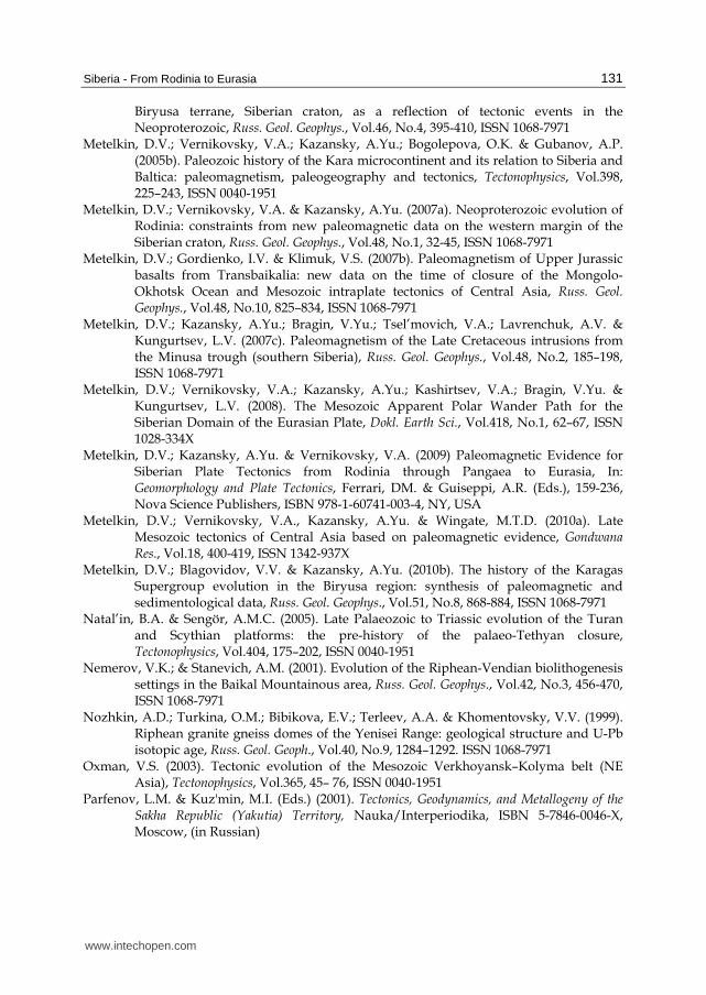
Siberia - From Rodinia to Eurasia
131
Biryusa terrane, Siberian craton, as a reflection of tectonic events in the Neoproterozoic, Russ. Geol. Geophys., Vol.46, No.4, 395-410, ISSN 1068-7971
Metelkin, D.V.; Vernikovsky, V.А.; Kazansky, A.Yu.; Bogolepova, O.K. & Gubanov, A.P. (2005b). Paleozoic history of the Kara microcontinent and its relation to Siberia and Baltica: paleomagnetism, paleogeography and tectonics, Tectonophysics, Vol.398, 225–243, ISSN 0040-1951
Metelkin, D.V.; Vernikovsky, V.A. & Kazansky, A.Yu. (2007a). Neoproterozoic evolution of Rodinia: constraints from new paleomagnetic data on the western margin of the Siberian craton, Russ. Geol. Geophys., Vol.48, No.1, 32-45, ISSN 1068-7971
Metelkin, D.V.; Gordienko, I.V. & Klimuk, V.S. (2007b). Paleomagnetism of Upper Jurassic basalts from Transbaikalia: new data on the time of closure of the Mongolo-Okhotsk Ocean and Mesozoic intraplate tectonics of Central Asia, Russ. Geol. Geophys., Vol.48, No.10, 825–834, ISSN 1068-7971
Metelkin, D.V.; Kazansky, A.Yu.; Bragin, V.Yu.; Tsel’movich, V.A.; Lavrenchuk, A.V. & Kungurtsev, L.V. (2007c). Paleomagnetism of the Late Cretaceous intrusions from the Minusa trough (southern Siberia), Russ. Geol. Geophys., Vol.48, No.2, 185–198, ISSN 1068-7971
Metelkin, D.V.; Vernikovsky, V.A.; Kazansky, A.Yu.; Kashirtsev, V.A.; Bragin, V.Yu. & Kungurtsev, L.V. (2008). The Mesozoic Apparent Polar Wander Path for the Siberian Domain of the Eurasian Plate, Dokl. Earth Sci., Vol.418, No.1, 62–67, ISSN 1028-334X
Metelkin, D.V.; Kazansky, A.Yu. & Vernikovsky, V.A. (2009) Paleomagnetic Evidence for Siberian Plate Tectonics from Rodinia through Pangaea to Eurasia, In: Geomorphology and Plate Tectonics, Ferrari, DM. & Guiseppi, A.R. (Eds.), 159-236, Nova Science Publishers, ISBN 978-1-60741-003-4, NY, USA
Metelkin, D.V.; Vernikovsky, V.A., Kazansky, A.Yu. & Wingate, M.T.D. (2010a). Late Mesozoic tectonics of Central Asia based on paleomagnetic evidence, Gondwana Res., Vol.18, 400-419, ISSN 1342-937X
Metelkin, D.V.; Blagovidov, V.V. & Kazansky, A.Yu. (2010b). The history of the Karagas Supergroup evolution in the Biryusa region: synthesis of paleomagnetic and sedimentological data, Russ. Geol. Geophys., Vol.51, No.8, 868-884, ISSN 1068-7971
Natal’in, B.A. & Sengör, A.M.C. (2005). Late Palaeozoic to Triassic evolution of the Turan and Scythian platforms: the pre-history of the palaeo-Tethyan closure, Tectonophysics, Vol.404, 175–202, ISSN 0040-1951
Nemerov, V.K.; & Stanevich, A.M. (2001). Evolution of the Riphean-Vendian biolithogenesis settings in the Baikal Mountainous area, Russ. Geol. Geophys., Vol.42, No.3, 456-470, ISSN 1068-7971
Nozhkin, A.D.; Turkina, O.M.; Bibikova, E.V.; Terleev, A.A. & Khomentovsky, V.V. (1999). Riphean granite gneiss domes of the Yenisei Range: geological structure and U-Pb isotopic age, Russ. Geol. Geoph., Vol.40, No.9, 1284–1292. ISSN 1068-7971
Oxman, V.S. (2003). Tectonic evolution of the Mesozoic Verkhoyansk–Kolyma belt (NE Asia), Tectonophysics, Vol.365, 45– 76, ISSN 0040-1951
Parfenov, L.M. & Kuz'min, M.I. (Eds.) (2001). Tectonics, Geodynamics, and Metallogeny of the Sakha Republic (Yakutia) Territory, Nauka/Interperiodika, ISBN 5-7846-0046-X, Moscow, (in Russian)
www.intechopen.com
Tectonics
132
Parfenov, L.M.; Prokopiev, A.V. & Gaiduk, V.V. (1995). Cretaceous frontal trusts of the Verkhoyansk fold belt, Eastern Siberia, Tectonics, Vol.4, No.2, 342-358, ISSN 0278-7407
Parfenov, L.M.; Bulgatov, A.N. & Gordienko, I.V. (1996). Terranes and formation of orogens in Transbaikalia, Tikhookeanskaya Geologiya, Vol.15, No.4, 3–15, ISSN 0207-4028, (in Russian)
Parfenov, L.M.; Berzin, N.A.; Khanchuk, A.I.; Badarch, G.; Belichenko, V.G.; Bulgatov, A.N.; Dril, S.I.; Kirillova, G.L.; Kuzmin, M.I.; Nokleberg, W.J.; Prokopyev, A.V.; Timofeev, V.F.; Tomurtogoo, O. & Yang, H. (2003). A model for the formation of orogenic belts in Central and Northeast Asia, Tikhookeanskaya Geologiya, Vol.22, No.6, 7-41, ISSN 0207-4028, (in Russian)
Pavlov, V.E. & Petrov, P.Yu. (1997). Paleomagnetism of the Riphean Deposits in the Irkineeva Uplift, Yenisei Range: New Evidence for the Integrity of the Siberian Platform in the Middle Riphean, Izv. Phys. Solid Earth, Vol.33, No.6, 464-475, ISSN 1069-3513
Pavlov, V.E.; Gallet, Y. & Shatsillo, A.V. (2000). Paleomagnetism of the Upper Riphean Lakhandinskaya Group in the Uchuro-Maiskii Area and the Hypothesis of the Late Proterozoic Supercontinent, Izv. Phys. Solid Earth, Vol.36, No.8, 638-648, ISSN 1069-3513
Pavlov, V.E.; Gallet, Y.; Petrov, P.Yu.; Zhuravlev, D.Z. & Shatsillo, A.V. (2002). Uy series and late Riphean sills of the Uchur-Maya area: isotopic and palaeomagnetic data and the problem of the Rodinia supercontinent, Geotectonics, Vol.36, 278–292, ISSN 0016-8521
Pavlov, V.E.; Gallet, Y.; Shatsillo, A.V. & Vodovozov, V.Yu. (2004). Paleomagnetism of the Lower Cambrian from the Lower Lena River Valley: Constraints on the Apparent Polar Wander Path from the Siberian Platform and the Anomalous Behavior of the Geomagnetic Field at the Beginning of the Phanerozoic, Izv. Phys. Solid Earth, Vol.40, No.2, 114-133 ISSN 1069-3513
Pease, V.; Gee, D.; Vernikovsky, V.; Vernikovskaya, A. & Kireev, S. (2001). The Mamont-Shrenk terrane: a Mesoproterozoic complex in the Neoproterozoic accretionary belt of Central Taimyr, Norhern Siberia, Terra Nova, 2001, Vol.13, 270-280, ISSN 0954-4879
Pechersky, D.M. & Didenko, A.N. (1995). The Paleoasian Ocean: Petromagnetic and Paleomagnetic Information on the Lithosphere, Schmidt Institute of Physics of the Earth RAS, ISBN 5-201-11898-4, Moscow, (in Russian)
Petrov, P.Y. & Semikhatov, M.A. (2001). Sequence organization and growth patterns of late Mesoproterozoic stromatolite reefs: an example from the Burovaya Formation, Turukhansk Uplift, Siberia, Precambrian Res., Vol.111, 257–281, ISSN 0301-9268
Pisarevsky, S.A. & Natapov, L.M. (2003). Siberia in Rodinia, Tectonophysics, Vol.375, 221-245, ISSN 0040-1951
Pisarevsky, S.A.; Komissarova, R.A. & Khramov A.N. (2000). New palaeomagnetic result from Vendian red sediments in Cisbaikalia and the problem of the relationship of Siberia and Laurentia in the Vendian, Geophys. J. Int., Vol.140, 598–610, ISSN 0956-540X
Pisarevsky, S.A.; Murphy, J.B.; Cawood, P.A. & Collins, A.S. (2008). Late Neoproterozoic and Early Cambrian palaeogeography: models and problems, In: West Gondwana:
www.intechopen.com
Siberia - From Rodinia to Eurasia
133
Pre-Cenozoic Correlations Across the South Atlantic Region, Pankhurst, R.J.; Trouw, R.A.J.; Brito Neves B. B. & De Wit M. J. (Eds.), 9-31, Geological Society of London, Spec. Publ., Vol.294, DOI: 10.1144/SP294.2
Rainbird, R.H.; Stern, R.A.; Khudoley, A.K.; Kropachev, A.P.; Heaman, L.M. & Sukhorukov, V.I. (1998). U-Pb geochronology of Riphean sandstone and gabbro from southeast Siberia and its bearing in the Laurentia-Siberia connection, Earth Planet Sci .Lett., Vol.164, 409-420, ISSN 0012-821X
Rosen, O.M. (2003). The Siberian Craton: Tectonic Zonation and Stages of Evolution, Geotectonics, Vol.37, No.3, 175-192, ISSN 0016-8521
Rosen, O.M.; Condie K.C.; Natapov, L.M. & Nozhkin, A.D. (1994). Archean and early Proterozoic evolution of the Siberian craton, a preliminary assessment, In: Archean crustal evolution, Condie, K.C.(Ed.), 411-459, Elsevier, ISBN: 978-0-444-81621-4 Netherlands
Rosen, O.M.; Manakov, A.V. & Serenko, V.P. (2005). Paleoproterozoic collisional system and diamondiferous lithospheric keel of the Yakutian kimberlite province, Russ. Geol. Geophys., Vol.46, No.12, 1237-1251, ISSN 1068-7971
Rytsk, E.Yu.; Amelin, Yu.V.; Rizvanova, N.G.; Krymsky, R.Sh.; Mitrofanov, G.L.; Mitrofanova, N.N.; Perelyaev, V.I. & Shalaev, B.C. (2001). Age of Rocks in the Baikal-Muya Foldbelt. Stratigr. Geol. Correl., Vol.9, No.4, 315-326, ISSN 0869-5938
Rytsk, E.Yu.; Kovach, V.P.; Kovalenko, V.I. & Yarmolyuk, V.V. (2007). Structure and Evolution of the Continental Crust in the Baikal Fold Region, Geotectonics, Vol.41, No.6, 440–464, ISSN 0016-8521
Safonova, I.Yu.; Simonov, V.A.; Buslov, M.M.; Ota, T.; Maruyama, Sh. (2008). Neoproterozoic basalts of the Paleo-Asian Ocean (Kurai accretion zone, Gorny Altai, Russia): geochemistry, petrogenesis, geodynamics. Russ. Geol. Geoph., Vol.49, No.4, 254–271, ISSN 1068-7971
Semikhatov, M.A.; Ovchinnikova, G.V.; Gorokhov, I.M.; Kuznetsov A.B.; Vasil’eva I.M.; Gorokhovskii, B.M. & Podkovyrov, V.N. (2000). Isotope Age of the Middle–Upper Riphean Boundary: Pb–Pb Geochronology of the Lakhanda Group Carbonates, Eastern Siberia, Dokl. Earth Sci., Vol.372, No.4, 625-629, ISSN 1028-334X
Нengör, A.M.C., Natalin B., Burtman V. (1993). Evolution of the Altaide tectonic collage and Paleozoic crustal growth in Eurasia, Nature, Vol.34, 299–307, ISSN 0028-0836
Shatsillo, A.V.; Didenko, A.N. & Pavlov, V.E. (2005). Two competing Paleomagnetic directions in the Late Vendian:new data for the SW Region of the Siberian Platform. Russ. J. Earth Sci., Vol.7, No.4, 3–24, ISSN 1681-1208
Shatsillo, А.V.; Pavlov, V.E. & Didenko, А.N. (2006). Paleomagnetism of Vendian rocks in the southwest of the Siberian Platform. Russ. J. Earth Sci., Vol.8, No.2, 1-30, ISSN 1681-1208
Sklyarov, E.V.; Gladkochub, D.P.; Mazukabzov, A.M.; Menshagin, Yu.V.; Watanabe, T. & Pisarevsky, S.A. (2003). Neoproterozoic mafic dike swarms of the Sharyzhalgai metamorphic massif (southern Siberian craton), Precambrian Res., Vol.22, 359–377, ISSN 0301-9268
Smelov, A.P. & Timofeev, V.F. (2007). The age of the North Asian Cratonic basement: An overview, Gondwana Res., Vol.12, p.279–288, ISSN 1342-937X
www.intechopen.com
Tectonics
134
Smethurst, M.A.; Khramov, A.N. & Torsvik, T.H. (1998). The Neoproterozoic and Palaeozoic palaeomagnetic data for the Siberian Platform: From Rodinia to Pangea, Earth Sci. Rev., Vol.43, No.1-2, 1–24, ISSN 0012-8252
Sovetov, Yu.K.; Blagovidov, V.V.; Luchinina, V.A. & Romashko, A.I. (2000). Vendian Sediments on the Western Enisei Ridge, Dokl. Earth Sci., Vol.372, No.4, 630-632, ISSN 1028-334X
Stanevich, A.M.; Mazukabzov, A.M.; Postnikov, A.A.; Nemerov, V.K.; Pisarevsky, S.A.; Gladkochub, D.P.; Donskaya, T.V. & Kornilova, T.A. (2007). Northern segment of the Paleoasian Ocean: Neoproterozoic deposition history and geodynamics, Russ. Geol. Geophys., Vol.48, No.1, 46-60, ISSN 1068-7971
Tomurtogoo, O.; Windley, B.F.; Kröner, A.; Badarch, G. & Liu, D.Y. (2005). Zircon age and occurrence of the Adaatsag ophiolite and Muron shear zone, central Mongolia: constraints on the evolution of the Mongol–Okhotsk ocean, suture and orogen, J. Geol Soc. Lond., Vol.162, 125–134, ISSN 0016-7649
Torsvik, T.H. & Cocks, L.R.M. (2005). Norway in space and time: A Centennial cavalcade, Norw. J. Geol., Vol.85, 73–86, ISSN 0029-196X
Torsvik, T.H. & Smethurst, M.A. (1999). Plate tectonic modelling: virtual reality with GMAP, Computers and Geosciences, Vol.25, 395–402, ISSN 0098-3004
Turkina, O.M.; Nozhkin, A.D.; Bayanova, T.B.; Dmitrieva, N.V. & Travin, A.V. Precambrian terranes in the southwestern framing of the Siberian craton: isotopic provinces, stages of crustal evolution and accretion-collision events, Russ. Geol. Geophys., Vol.48, No.1, 61-70, ISSN 1068-7971
Uflyand, A.K.; Natapov, L.M.; Lopatin, V.M. & Chernov, D.V. (1991). On the tectonic nature of Taimyr, Geotectonics, Vol.25, No.6, 76–93, ISSN 0016-8521
Van der Voo, R. (1990). The reliability of pаleomagnetic data, Tectonophysics, Vol.184, 1–9, ISSN 0040-1951
Van der Voo, R.; Levashova N.M.; Skrinnik, L.I.; Kara, T.V. & Bazhenov, M.L. (2006). Late orogenic, large-scale rotations in the Tien Shan and adjacent mobile belts in Kyrgyzstan and Kazakhstan, Tectonophysics, Vol.426, 335–360, ISSN 0040-1951
Vernikovskaya, A.E.; Vernikovsky, V.A.; Sal’nikova, E.B.; Kotov, A.B.; Kovach, V.P.; Travin, A.V.; Palesskii, S.V.; Yakovleva, S.Z.; Yasenev, A.M. & Fedoseenko, A.M. (2003). Neoproterozoic Postcollisional Granitoids of the Glushikha Complex, Yenisei Range, Petrology, Vol.11, No1, 48-61, ISSN 0869-5911
Vernikovskaya, A.E.; Vernikovsky, V.A.; Sal’nikova, E.B.; Yasenev, A.M; Kotov, A.B.; Kovach, V.P.; Travin, A.V.; Yakovleva, S.Z. & Fedoseenko, A.M. (2006). Neoproterozoic A-Type Granites of the Garevka Massif, Yenisey Ridge: Age, Sources, and Geodynamic Setting, Petrology, Vol.14, No1, 50-61, ISSN 0869-5911
Vernikovsky, V.A. (1996). Geodynamic Evolution of Taimyr Folded Area, SB RAS Publicher, ISBN 5-7692-0015-4, Novosibirsk, (in Russian)
Vernikovsky, V.A. & Vernikovskaya, A.E. (2001). Central Taimyr accretionary belt (Arctic Asia): Meso-Neoproterozoic tectonic evolution and Rodinia breakup, Precambrian Res., Vol.110, 127–141, ISSN 0301-9268
Vernikovsky, V.A. & Vernikovskaya, A.E. (2006) Tectonics and evolution of granitoid magmatism in the Yenisei Ridge, Russ. Geol. Geophys., Vol.47, No.1, 32–50, ISSN 1068-7971
www.intechopen.com
Siberia - From Rodinia to Eurasia
135
Vernikovsky, V.A.; Kotov, A.B.; Ponomarchuk, V.A.; Sal’nikova, E.B., Kovach, V.P., & Travin, A.V. (1997). Late Riphean–Vendian Event in the Northern Taimyr Evolution: Evidence from Sm–Nd, Rb–Sr and K–Ar Dating of the Garnet Amphibolites of the Stanovaya Ophiolite Belt, Dokl. Earth Sci., Vol.352, No.1, 11-14, ISSN 1028-334X
Vernikovsky, V.A.; Vernikovskaya, A.E.; Sal’nikova, E.B.; Kotov, A.B.; Chernykh, A.I.; Kovach, V.P.; Berezhnaya, N.G. & Yakovleva, S.Z. (1999). New U-Pb data on the formation of the Predivinsk paleoisland-arc complex (Yenisei Range), Russ. Geol. Geophys., Vol.40, No.2, 255–259, ISSN 1068-7971
Vernikovsky, V.A.; Vernikovskaya, A.E.; Kotov, A.B.; Sal’nikova, E.B. & Kovach V.P. (2003). Neoproterozoic accretionary and collisional events on the western margin of the Siberian craton: new geological and geochronological evidence from the Yenisey Ridge, Tectonophysics, Vol.375, 147–168, ISSN 0040-1951
Vernikovsky, V.A.; Vernikovskaya, A.E.; Pease, V.L. & Gee, D.G. (2004). Neoproterozoic orogeny along the margins of Siberia, In: The Neoproterozoic Timanide orogen of Eastern Baltica, Gee, D.G. & Pease, V.L. (Eds.), Geol. Soc. London Mem., Vol.30, 233–247.
Vernikovsky, V.A.; Vernikovskaya, A.E.; Sal’nikova, E.B.; Berezhnaya, N.G.; Larionov, A.N.; Kotov, A.B.; Kovach, V.P.; Vernikovskaya, I.V.; Matushkin, N.Yu. & Yasenev, A.M. (2008). Late Riphean Alkaline Magmatism in the Western Framework of the Siberian Craton: A Result of Continental Rifting or Accretionary Events?, Dokl. Earth Sci., Vol.419, No.2, 226-230, ISSN 1028-334X
Vernikovsky, V.A.; Kazansky, A.Yu.; Matushkin, N.Yu.; Metelkin, D.V. & Sovetov. J.K. (2009). The geodynamic evolution of the folded framing and the western margin of the Siberian craton in the Neoproterozoic: geological, structural, sedimentological, geochronological and paleomagnetic data, Russ. Geol. Geophys., Vol.50, No.4, 372-387, ISSN 1068-7971
Vladimirov, A.G.; Kozlov, M.S.; Shokal'skii, S.P.; Khalilov, V.A.; Rudnev, S.N.; Kruk, N.N.; Vystavnoi, S.A.; Borisov, S.M.; Berezikov, Yu.K.; Metsner, A.N.; Babin, G.A.; Mamlin, A.N.; Murzin, O.M.; Nazarov, G.V. & Makarov, V.A. (2001). Major epochs of intrusive magmatism of Kuznetsk Alatau, Altai, and Kalba (from U-Pb isotopedates), Russ. Geol. Geophys., Vol.42, No.8, 1157-1178, ISSN 1068-7971
Voronov, P.S. (Ed.) (1997). Role of strike-slip tectonics in the lithosphere structure of the Earth and terrestrial planets. Nauka, ISBN 5-02-024832-0, St.Petersburg, (in Russian)
Yarmolyuk, V.V. & Kovalenko, V.I. (2001). Late Riphean breakup between Siberia and Laurentia: Evidence from intraplate magmatism, Dokl. Earth Sci., Vol.379, No.5, 525–528, ISSN 1028-334X
Yarmolyuk, V.V.; Kovalenko, V.I.; Sal’nikova, E.B.; Nikiforov, A.V.; Kotov, A.B. & Vladykin, N.V. (2005). Late Riphean Rifting and Breakup of Laurasia: Data on Geochronological Studies of Ultramafic Alkaline Complexes in the Southern Framing of the Siberian Craton, Dokl. Earth Sci., Vol.404, No.7, 1031-1036, ISSN 1028-334X
Zonenshain, L.P., Kuzmin, M.I., Natapov, L.M. (1990). Geology of the USSR: a plate tectonic synthesis. Amer. Geoph. Union, ISBN 0-87-590521-8, Washington, USA
www.intechopen.com

Tectonics
136
Zorin, Yu.A. (1999). Geodynamics of the western part of the Mongolia.Okhotsk collisional belt, Trans-Baikal region (Russia) and Mongolia, Tectonophysics, Vol.306, 33–56, ISSN 0040-1951
Zorin, Yu.A.; Sklyarov, E.V.; Belichenko, V.G. & Mazukabzov, A.M. (2009). Island arc–back-arc basin evolution: implications for Late Riphean–Early Paleozoic geodynamic history of the Sayan–Baikal folded area, Russ. Geol. Geophys., Vol.50, No.3, 149-161, ISSN 1068-7971
www.intechopen.com
TectonicsEdited by Dr. Damien Closson
ISBN 978-953-307-545-7Hard cover, 358 pagesPublisher InTechPublished online 28, February, 2011Published in print edition February, 2011
InTech EuropeUniversity Campus STeP Ri Slavka Krautzeka 83/A 51000 Rijeka, Croatia Phone: +385 (51) 770 447 Fax: +385 (51) 686 166www.intechopen.com
InTech ChinaUnit 405, Office Block, Hotel Equatorial Shanghai No.65, Yan An Road (West), Shanghai, 200040, China
Phone: +86-21-62489820 Fax: +86-21-62489821
The term tectonics refers to the study dealing with the forces and displacements that have operated to createstructures within the lithosphere. The deformations affecting the Earth's crust are result of the release and theredistribution of energy from Earth's core. The concept of plate tectonics is the chief working principle.Tectonics has application to lunar and planetary studies, whether or not those bodies have active tectonicplate systems. Petroleum and mineral prospecting uses this branch of knowledge as guide. The present bookis restricted to the structure and evolution of the terrestrial lithosphere with dominant emphasis on thecontinents. Thirteen original scientific contributions highlight most recent developments in seven relevantdomains: Gondwana history, the tectonics of Europe and the Near East; the tectonics of Siberia; the tectonicsof China and its neighbourhood; advanced concepts on plate tectonics are discussed in two articles; in theframe of neotectonics, two investigation techniques are examined; finally, the relation between tectonics andpetroleum researches is illustrated in one chapter.
How to referenceIn order to correctly reference this scholarly work, feel free to copy and paste the following:
Dmitry V. Metelkin, Valery A. Vernikovsky and Alexey Yu. Kazansky (2011). Siberia - From Rodinia to Eurasia,Tectonics, Dr. Damien Closson (Ed.), ISBN: 978-953-307-545-7, InTech, Available from:http://www.intechopen.com/books/tectonics/siberia-from-rodinia-to-eurasia

© 2011 The Author(s). Licensee IntechOpen. This chapter is distributedunder the terms of the Creative Commons Attribution-NonCommercial-ShareAlike-3.0 License, which permits use, distribution and reproduction fornon-commercial purposes, provided the original is properly cited andderivative works building on this content are distributed under the samelicense.
Top Related