


Languages
Pages
Legal

Dublin City Council Proposed College Green Project - ABP Ref No: 29SJA0039 Response to further information request from An Bord Pleanála on behalf of Dublin City
Council
Page REP1 | Issue | 19 October 2017 | Arup
3 Further Information Request Responses
3.1 Further Information Request No. 13.1.1 Question raisedIt is the opinion of the Board that the requirements of amending Directive 2014/52/EU apply to the proposed development. In this regard attention is drawn to the provisions of Circular letter PL1/2017 issued by the Department of Housing, Planning, Community and Local Government on May 15th, 2017, which states:
“Where screening for EIA has commenced prior to 16 May 2017 and is carried out in accordance with Directive 2011/92/EU, but the application for planning permission or other development consent and accompanying EIS, where EIS is determined to be required, is submitted on or after May 2017, the application will fall to be dealt with in accordance with Directive 2014/52/EU.”
To comply with these requirements, an EIAR shall be prepared and submitted to the Board in accordance with the requirements and the general format set out in the Directive. Due regard shall be had to its amending provisions in terms of the information to be provided (Article 5) and Annex IV and the environmental factors to be considered by the competent authority in carrying out EIA (Article 3(1) (a) to (e) and Article 3(2)).
The EIAR shall be supported by a schedule highlighting changes to the original EIS submitted and shall also have regard to the matters referred to at 2 to 6 below.
3.1.2 Response to Further Information Request No. 1On 18 July 2016, Dublin City Council initiated a screening determination process pursuant to Article 4(2) of Directive 2011/92/EU and article 120(1) of the Planning and Development Regulations 2001, as amended, and engaged CAAS Ltd. to carry out Environmental Impact Statement [EIS] Screening in respect of the proposed development of a new civic plaza and ancillary traffic management measures at College Green (“the Project”). In August 2016, Dublin City Council determined that, although the project was sub-threshold, it was “likely to have significant effects on the environment”. Accordingly, in November 2016, Dublin City Council caused an EIS to be prepared and, on 18 May 2017, an application for approval of that EIS was submitted to An Bord Pleanála. The local authority’s screening determination was included in the application documentation, at Appendix 1.1 to the EIS.

Dublin City Council Proposed College Green Project - ABP Ref No: 29SJA0039 Response to further information request from An Bord Pleanála on behalf of Dublin City
Council
Page REP1 | Issue | 19 October 2017 | Arup
Transitional provisions are contained in Directive 2014/52/EU. Firstly, Recital (39) states:
“(39) In accordance with the principles of legal certainty and proportionality and in order to ensure that the transition from the existing regime, laid down in Directive 2011/92/EU, to the new regime that will result from the amendments contained in this Directive is as smooth as possible, it is appropriate to lay down transitional measures… Accordingly, the related provisions of Directive 2011/92/EU prior to its amendment by this Directive should apply to projects for which the screening procedure has been initiated, the scoping procedure has been initiated, (where scoping was requested by the developer or required by the competent authority) or the environmental impact assessment report is submitted before the time-limit for transposition”.
Thereafter, Article 3 of Directive 2014/52/EU provides:
1. Projects in respect of which the determination referred to in Article 4(2) of Directive 2011/92/EU was initiated before 16 May 2017 shall be subject to the obligations referred to in Article 4 of Directive 2011/92/EU prior to its amendment by this Directive.
2. Projects shall be subject to the obligations referred to in Article 3 and Articles 5 to 11 of Directive 2011/92/EU prior to its amendment by this Directive where, before 16 May 2017:
(a) the procedure regarding the opinion referred to in Article 5(2) of Directive 2011/92/EU was initiated; or
(b) the information referred to in Article 5(1) of Directive 2011/92/EU was provided.
Article 120 of the 2001 Regulations relates to “Sub-threshold EIS” and provides as follows:
(1) Where a local authority proposes to carry out a sub-threshold development and the likelihood of significant effects on the environment cannot be excluded by the authority, the authority shall make a determination as to whether the development would be likely to have significant effects on the environment, and where it determines that the development would be likely to have such significant effects it shall prepare, or cause to be prepared, an EIS in respect thereof.
Accordingly, it is the local authority which is the competent authority to make a determination as to whether its own development should be “screened in” or “screened out” for the purposes of Environmental Impact Assessment [EIA]. As set out above, in August 2016, Dublin City Council decided to “screen in” the Project and, as a consequence, caused an EIS to be prepared. Pursuant to Article 120(5) of the 2001 Regulations, Dublin City Council was required to apply to the Board for approval, which it did on 18 May 2017.
In circumstances where the Project is one in respect of which a screening determination was initiated before 16 May 2017, Dublin City Council was of the view that the Project was subject to the provisions of Directive 2011/92/EU, prior to its amendment by Directive 2014/52/EU. In any event, the EIS submitted with the application for approval was prepared in substantial compliance with the provisions of Directive 2014/52/EU.
Dublin City Council Proposed College Green Project - ABP Ref No: 29SJA0039 Response to further information request from An Bord Pleanála on behalf of Dublin City
Council
Page REP1 | Issue | 19 October 2017 | Arup
However, in response to the request from An Bord Pleanála, an Environmental Impact Assessment Report [EIAR] for the Proposed College Green Project has now been prepared in accordance with Directive 2014/52/EU. Three hardcopies and one electronic copy of the EIAR have been submitted to An Bord Pleanála, as required by this RFI. A ‘Schedule of Amendments’ which documents all of the changes made to the May 2017 EIS is included in Appendix A to this report. It should be noted that other documents that were included in the planning application such as the scheme drawings, stand-alone Report for Appropriate Assessment and photomontages have not been resubmitted as part of this EIAR.
3.2 Further Information Request No. 23.2.1 Question raisedProvide a comprehensive assessment of the impacts of the proposed traffic management measures (direct, indirect and cumulative) taken in conjunction with other traffic management proposals for the city centre on all transport modes. This should make particular reference, but not be limited to the proposals set out in the Dublin City Centre Transport Study, the Transport Strategy for the Greater Dublin Area 2016-2035 and the Greater Dublin Area Cycle Network Plan.
The assessment shall include a description and assessment of how changes in traffic routes for vehicle/changes in traffic flows (other than buses) will impact on individual streets in the vicinity, designated pedestrian routes, on access to commercial premises and residents, on the operational needs of businesses including access to loading/unloading facilities, car parks (both private and public). The assessment shall address the wider city implications of removing traffic from College Green and the adequacy of infrastructure.
Appendix 6.1 should be amended to include a ‘do-nothing’ scenario where the 2018 traffic flows are modelled on the current road network and traffic management regime. Appendix6.1 should then indicate the differences between a ‘do-nothing’ and ‘do-minimum’ and ‘do- something’ scenario. Details of the modelling methodology used throughout the EIAR should be clarified.
3.2.2 Response to Further Information Request No. 2- Assessment Methodology
Chapter 6 of the EIAR updates the previously submitted Transport Assessment contained within the May 2017 EIS Chapter 6, incorporating the additional information request responses presented in this section.
The assessment has been carried-out with the support of transport modelling work undertaken by the National Transport Authority (NTA) using the East Regional Model (ERM). The ERM was developed by the NTA for the purposes of the appraisal of potential future transport and land use scenarios.
The full modelling methodology and outputs are contained within the ‘College Green Traffic Management Measures Modelling Report’ prepared by the NTA, included as Appendix B of this RFI Response Document and Appendix 6.1 of the EIAR.
The ERM was used for the May 2017 EIS, but has been re-run to address particular points raised in the RFI. It is therefore important to note that the modelling results contained in the aforementioned report and referred to in this response, although similar, are not directly comparable with those presented in the May 2017 EIS.
Dublin City Council Proposed College Green Project - ABP Ref No: 29SJA0039 Response to further information request from An Bord Pleanála on behalf of Dublin City
Council
Page REP1 | Issue | 19 October 2017 | Arup
Assessment Scenarios
In preparing the updated assessment, as requested by An Bord Pleanála, consideration has been given to three assessment scenarios, being;
A ‘do-nothing’ scenario;
A ‘do-minimum’ scenario’ and
A ‘do-something’ scenario.
Each of these scenarios are described in the following sections.
The ‘do-nothing’ scenario
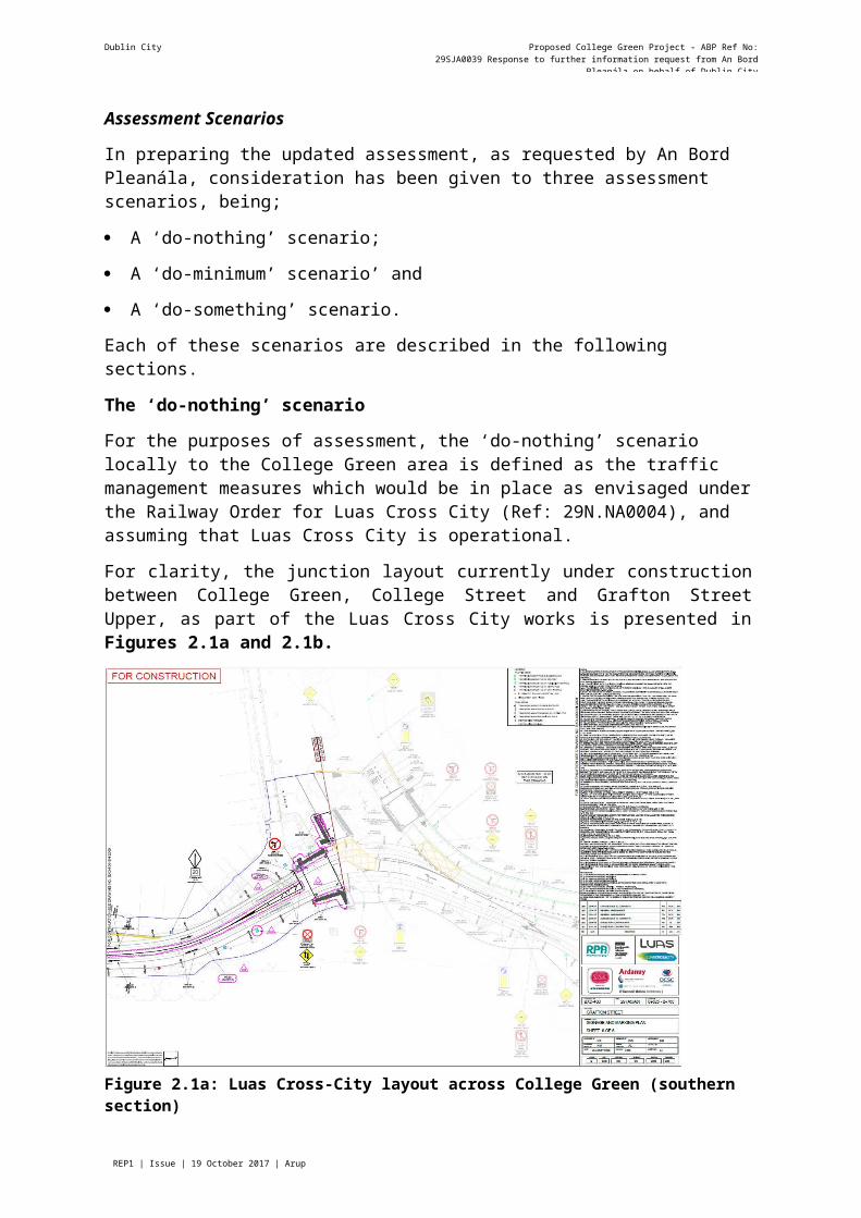
For the purposes of assessment, the ‘do-nothing’ scenario locally to the College Green area is defined as the traffic management measures which would be in place as envisaged under the Railway Order for Luas Cross City (Ref: 29N.NA0004), and assuming that Luas Cross City is operational.
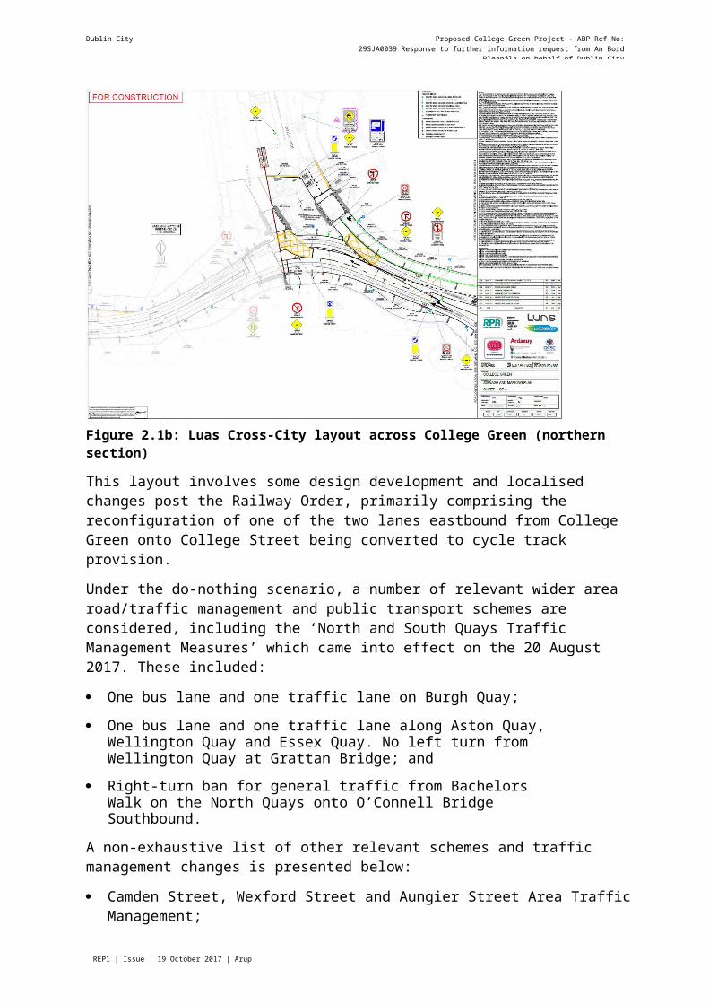
For clarity, the junction layout currently under construction between College Green, College Street and Grafton Street Upper, as part of the Luas Cross City works is presented in Figures 2.1a and 2.1b.
Figure 2.1a: Luas Cross-City layout across College Green (southern section)
Dublin City Council Proposed College Green Project - ABP Ref No: 29SJA0039 Response to further information request from An Bord Pleanála on behalf of Dublin City
Council
Page REP1 | Issue | 19 October 2017 | Arup
Figure 2.1b: Luas Cross-City layout across College Green (northern section)
This layout involves some design development and localised changes post the Railway Order, primarily comprising the reconfiguration of one of the two lanes eastbound from College Green onto College Street being converted to cycle track provision.
Under the do-nothing scenario, a number of relevant wider area road/traffic management and public transport schemes are considered, including the ‘North and South Quays Traffic Management Measures’ which came into effect on the 20 August 2017. These included:
One bus lane and one traffic lane on Burgh Quay;
One bus lane and one traffic lane along Aston Quay, Wellington Quay and Essex Quay. No left turn from Wellington Quay at Grattan Bridge; and
Right-turn ban for general traffic from Bachelors Walk on the North Quays onto O’Connell Bridge Southbound.
A non-exhaustive list of other relevant schemes and traffic management changes is presented below:
Camden Street, Wexford Street and Aungier Street Area Traffic Management;
St Stephen's Green Area Traffic Management;
Lincoln Place, Merrion Street and Westland Row Area Traffic Management;
Public transport (bus and taxi) only from O’Connell Street to Rosie Hackett Bridge;
Kildare Street converted to bus-only with the exception of local access;
Clanbrassil Street / Patrick Street and Bride Street QBC;
Thomas Street / James's Street Quality Bus Corridor (QBC); and
Dublin City Council Proposed College Green Project - ABP Ref No: 29SJA0039 Response to further information request from An Bord Pleanála on behalf of Dublin City
Council
Page REP1 | Issue | 19 October 2017 | Arup
Custom House Quay Contra Flow Bus Lane.
In addition, the following local traffic management arrangements would pertain to College Green and local environs:
General traffic movement restricted to local access and servicing of businesses on College Green from Dame Street only via enforcement of the College Green Bus Gate arrangement;
Restrictions on general vehicular movement, with the ‘College Green Bus Gate restrictions’ implemented on a 24-hour basis when Luas becomes operational;
West to east bus and taxi movement through, and from College Green onto College Street and onwards to Westmoreland Street;
East to west bus and taxi movement from College Street to College Green; A signalised junction between College Green and College Street, incorporating Luas running to / from Grafton Street Upper and pedestrian crossings on both College Green and Grafton Street Upper;
Shared Luas, Bus and Taxi southbound on Grafton Street Lower; and
No right turn to Nassau Street from Dawson Street. Two-way traffic along Dawson Street between St. Stephens Green and Duke Street, public transport only north of Duke Street.
As requested by the RFI, in order to assess impact on current traffic flows, the 2018 ERM assessment year has been used, with the ‘do-nothing’ road and street network coded in the model. The resulting predicted traffic flow data has been extracted for comparative assessment purposes.
The ‘do-minimum’ scenario
The ‘do-minimum’ scenario for the purposes of assessment is defined as the ‘do-nothing’ scenario’ plus any additional measures which are likely to be introduced in parallel by Dublin City Council in the short term, and in the absence of the College Green Project, in order to improve overall transport network management in the vicinity of College Green. The additional measures are therefore included in the ‘do-minimum’ scenario therefore comprise the following;
Pedestrianisation of Suffolk Street as an extension of the Grafton Street Pedestrian zone (proposed as part of the Dublin City Centre Transport Study); and
Changes to traffic management arrangements on Grafton Street Lower to allow for two- way traffic for Luas, buses and taxis (proposed as part of the Dublin City Centre Transport Study). Previously the Luas Cross City Railway Order assumed segregated Luas running northbound on Graton Street Lower. This change is primarily intended to facilitate improved bus service routing and flexibility; and
New cycle track along northern side of College Green, between Foster Place and Westmoreland Street.
The ‘do-something’ scenario
This scenario adds the proposed College Green Project, as described in detail in Chapter 4 of the EIAR, to the ‘do-minimum’ scenario.
Dublin City Council Proposed College Green Project - ABP Ref No: 29SJA0039 Response to further information request from An Bord Pleanála on behalf of Dublin City
Council
Page REP1 | Issue | 19 October 2017 | Arup
3.2.3 Response to FI Request No. 2 - Impact on PedestriansA key aim of the Proposed Project is to create a new pedestrian plaza, and therefore the design includes significant improvements for pedestrians, both moving through College Green and congregating to enjoy the planned new civic space within the city.
The benefits of the Proposed Project on how pedestrian desire lines for movement through College Green are accommodated have been analysed using the Pedestrian Route Directness (PRD) methodology, as prescribed in the NTA’s document “Permeability Best Practice”.PRD compares the deviations from a pedestrian desire line (as the crow flies) taking into account the actual existing and proposed street layouts, location of formal pedestrian crossings and obstacles. The lowest possible value is 1.0 with 1.2 – 1.5 regarded as acceptable standards.
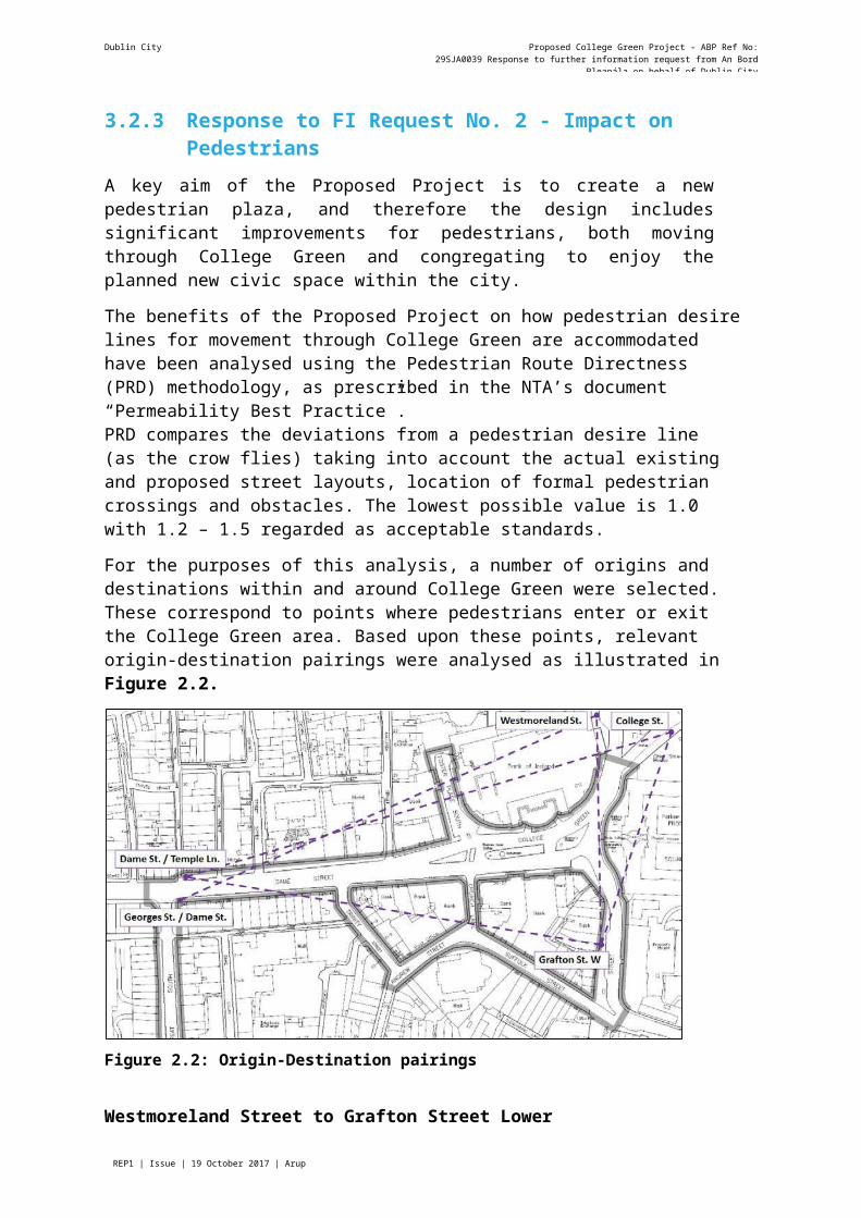
For the purposes of this analysis, a number of origins and destinations within and around College Green were selected. These correspond to points where pedestrians enter or exit the College Green area. Based upon these points, relevant origin-destination pairings were analysed as illustrated in Figure 2.2.
Figure 2.2: Origin-Destination pairings
Westmoreland Street to Grafton Street Lower
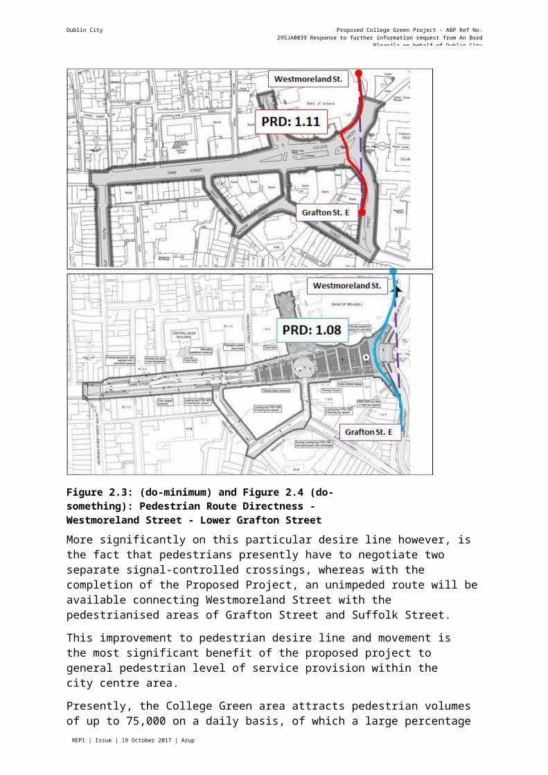
The PRD between the western footway on Westmoreland Street and the western footway on Grafton Street Lower is seen to improve slightly from the existing 1.11 to 1.08 following the implementation of the Proposed Project, as shown in Figure 2.3 (do-minimum) and Figure2.4 (do-something).
Dublin City Council Proposed College Green Project - ABP Ref No: 29SJA0039 Response to further information request from An Bord Pleanála on behalf of Dublin City
Council
Page REP1 | Issue | 19 October 2017 | Arup
Figure 2.3: (do-minimum) and Figure 2.4 (do-something): Pedestrian Route Directness - Westmoreland Street - Lower Grafton Street
More significantly on this particular desire line however, is the fact that pedestrians presently have to negotiate two separate signal-controlled crossings, whereas with the completion of the Proposed Project, an unimpeded route will be available connecting Westmoreland Street with the pedestrianised areas of Grafton Street and Suffolk Street.
This improvement to pedestrian desire line and movement is the most significant benefit of the proposed project to general pedestrian level of service provision within the city centre area.
Presently, the College Green area attracts pedestrian volumes of up to 75,000 on a daily basis, of which a large percentage is estimated to circulate between Westmoreland Street and Grafton Street. The elimination of the two signal controlled crossings through College Green as a result of the proposed project, effectively results in a largely unimpeded pedestrian priority route all the way from O’Connell Bridge to St Stephen’s Green (i.e. along the footpaths on the western side of Westmoreland Street and College Street, via College Green and on to Grafton Street).
Dublin City Council Proposed College Green Project - ABP Ref No: 29SJA0039 Response to further information request from An Bord Pleanála on behalf of Dublin City
Council
Page REP1 | Issue | 19 October 2017 | Arup
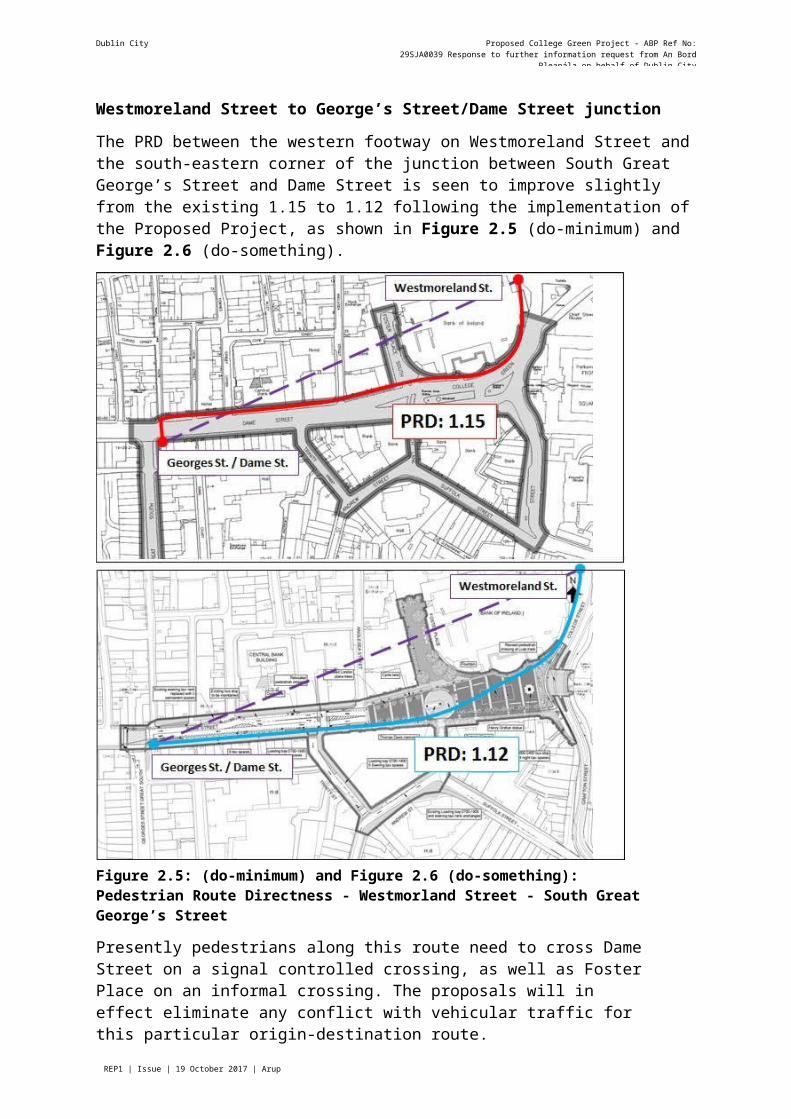
Westmoreland Street to George’s Street/Dame Street junction
The PRD between the western footway on Westmoreland Street and the south-eastern corner of the junction between South Great George’s Street and Dame Street is seen to improve slightly from the existing 1.15 to 1.12 following the implementation of the Proposed Project, as shown in Figure 2.5 (do-minimum) and Figure 2.6 (do-something).
Figure 2.5: (do-minimum) and Figure 2.6 (do-something): Pedestrian Route Directness - Westmorland Street - South Great George’s Street
Presently pedestrians along this route need to cross Dame Street on a signal controlled crossing, as well as Foster Place on an informal crossing. The proposals will in effect eliminate any conflict with vehicular traffic for this particular origin-destination route.
College Street to Dame Street/Temple Lane junction
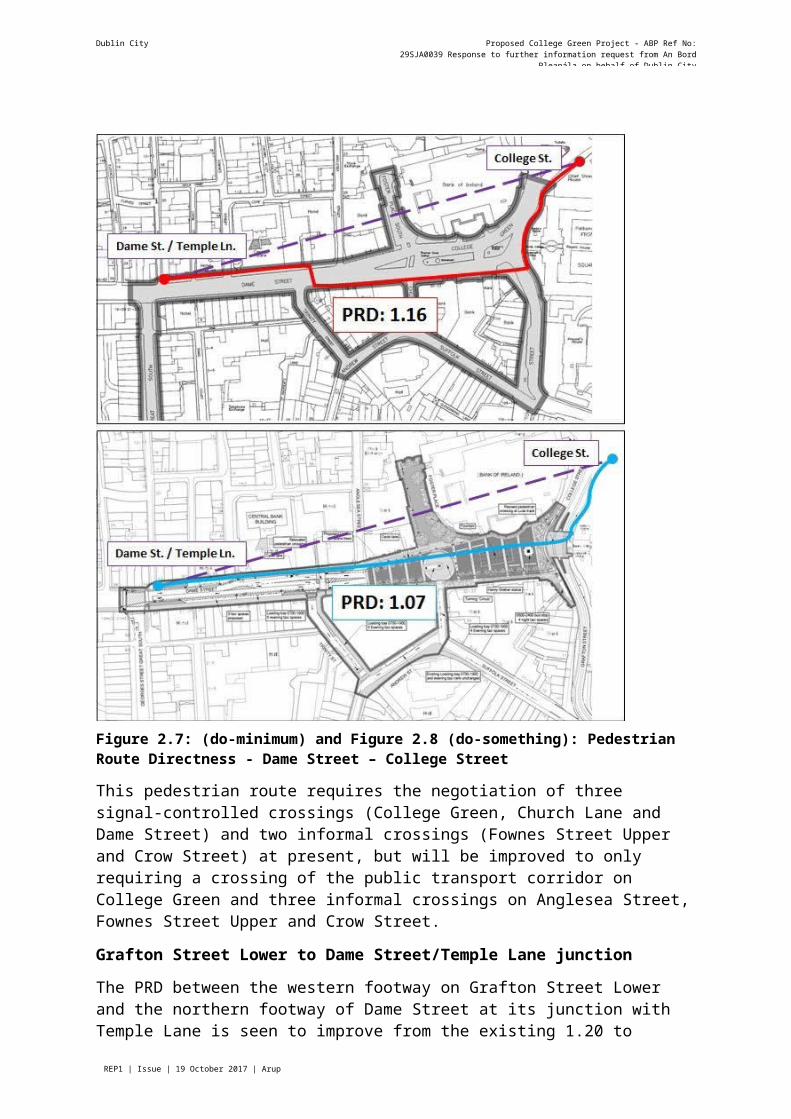
The PRD between the southern footway on College Street and the northern footway of Dame Street at its junction with Temple Lane is seen to improve significantly from the existing 1.16 to 1.07 following the implementation of the Proposed Project, as shown in Figure 2.7 (do- minimum) and Figure 2.8 (do-something).
Dublin City Council Proposed College Green Project - ABP Ref No: 29SJA0039 Response to further information request from An Bord Pleanála on behalf of Dublin City
Council
Page REP1 | Issue | 19 October 2017 | Arup
Figure 2.7: (do-minimum) and Figure 2.8 (do-something): Pedestrian Route Directness - Dame Street – College Street
This pedestrian route requires the negotiation of three signal-controlled crossings (College Green, Church Lane and Dame Street) and two informal crossings (Fownes Street Upper and Crow Street) at present, but will be improved to only requiring a crossing of the public transport corridor on College Green and three informal crossings on Anglesea Street, Fownes Street Upper and Crow Street.
Grafton Street Lower to Dame Street/Temple Lane junction
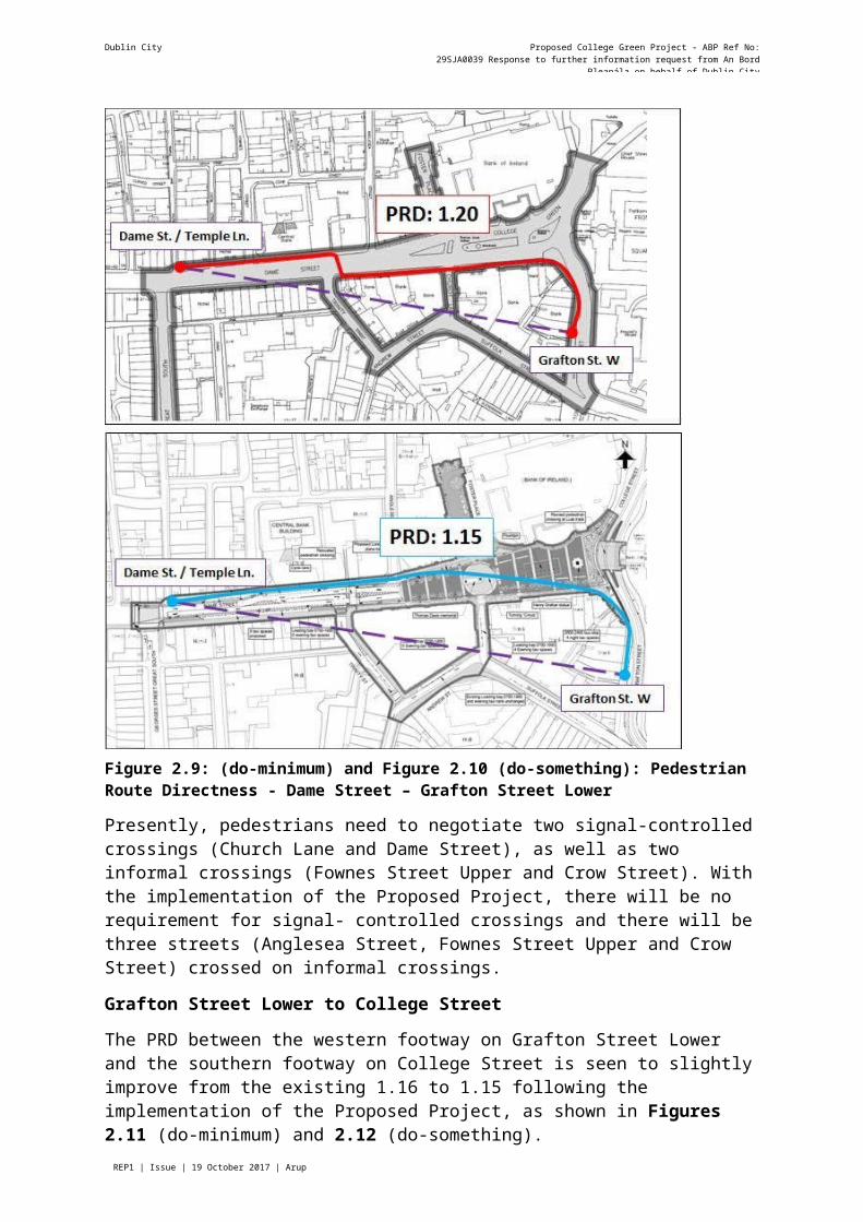
The PRD between the western footway on Grafton Street Lower and the northern footway of Dame Street at its junction with Temple Lane is seen to improve from the existing 1.20 to1.15 following the implementation of the proposed project, as shown in Figure 2.9 (do- minimum) and Figure 2.10 (do-something).
Dublin City Council Proposed College Green Project - ABP Ref No: 29SJA0039 Response to further information request from An Bord Pleanála on behalf of Dublin City
Council
Page REP1 | Issue | 19 October 2017 | Arup
Figure 2.9: (do-minimum) and Figure 2.10 (do-something): Pedestrian Route Directness - Dame Street – Grafton Street Lower
Presently, pedestrians need to negotiate two signal-controlled crossings (Church Lane and Dame Street), as well as two informal crossings (Fownes Street Upper and Crow Street). With the implementation of the Proposed Project, there will be no requirement for signal- controlled crossings and there will be three streets (Anglesea Street, Fownes Street Upper and Crow Street) crossed on informal crossings.
Grafton Street Lower to College Street
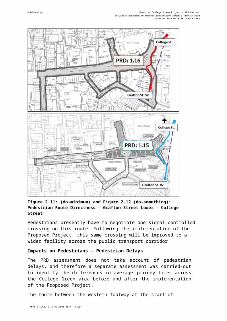
The PRD between the western footway on Grafton Street Lower and the southern footway on College Street is seen to slightly improve from the existing 1.16 to 1.15 following the implementation of the Proposed Project, as shown in Figures 2.11 (do-minimum) and 2.12 (do-something).
Dublin City Council Proposed College Green Project - ABP Ref No: 29SJA0039 Response to further information request from An Bord Pleanála on behalf of Dublin City
Council
Page REP1 | Issue | 19 October 2017 | Arup
Figure 2.11: (do-minimum) and Figure 2.12 (do-something): Pedestrian Route Directness - Grafton Street Lower - College Street
Pedestrians presently have to negotiate one signal-controlled crossing on this route. Following the implementation of the Proposed Project, this same crossing will be improved to a wider facility across the public transport corridor.
Impacts on Pedestrians – Pedestrian Delays
The PRD assessment does not take account of pedestrian delays, and therefore a separate assessment was carried-out to identify the differences in average journey times across the College Green area before and after the implementation of the Proposed Project.
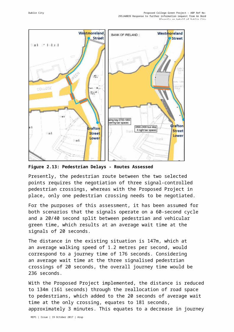
The route between the western footway at the start of Westmoreland Street and the eastern footway on Grafton Street Lower is representative of the changes to pedestrian movements effected by the pedestrianisation of College Green. Figure 2.13 illustrates this route comparing the existing situation and the Proposed Project.
Dublin City Council Proposed College Green Project - ABP Ref No: 29SJA0039 Response to further information request from An Bord Pleanála on behalf of Dublin City
Council
Page REP1 | Issue | 19 October 2017 | Arup
Figure 2.13: Pedestrian Delays - Routes Assessed
Presently, the pedestrian route between the two selected points requires the negotiation of three signal-controlled pedestrian crossings, whereas with the Proposed Project in place, only one pedestrian crossing needs to be negotiated.
For the purposes of this assessment, it has been assumed for both scenarios that the signals operate on a 60-second cycle and a 20/40 second split between pedestrian and vehicular green time, which results at an average wait time at the signals of 20 seconds.
The distance in the existing situation is 147m, which at an average walking speed of 1.2 metres per second, would correspond to a journey time of 176 seconds. Considering an average wait time at the three signalised pedestrian crossings of 20 seconds, the overall journey time would be 236 seconds.
With the Proposed Project implemented, the distance is reduced to 134m (161 seconds) through the reallocation of road space to pedestrians, which added to the 20 seconds of average wait time at the only crossing, equates to 181 seconds, approximately 3 minutes. This equates to a decrease in journey time between the do-minimum and do-something scenarios of over 23%.
The above quantitative comparison also needs to be considered in the context of the quality of service provided to pedestrians on both scenarios. The need to negotiate three junctions on a relatively short length of route means that there is a discomfort associated with the areas for waiting at the signals. These areas, at peak times, are busy with waiting pedestrians, which in turn, become obstacles to moving pedestrians.
Dublin City Council Proposed College Green Project - ABP Ref No: 29SJA0039 Response to further information request from An Bord Pleanála on behalf of Dublin City
Council
Page REP1 | Issue | 19 October 2017 | Arup
In the do-minimum scenario, this occurs mainly at the northern and eastern footways, where the pedestrian space is limited by the Bank of Ireland and Trinity College buildings.
In the do-something scenario, the whole of College Green west of the Luas corridor will be a pedestrian area, thus without circulation constraints. This will encourage the majority of pedestrian movements to occur here rather than on the eastern side, where conflicts with signalised crossing waiting areas will still be present.
Impacts on Pedestrians – Summary
It is clear from the PDR analysis that, in addition to the civic space itself as a new attractive place of congregation within the city, the proposed project will result in positive benefits to pedestrian movements through, and wider linkages within the city centre area.
These benefits will be mainly felt in terms of the directness of routes created along desire lines and the level of service improvements for pedestrian movement, in some cases catering for significant volumes of pedestrians, associated with the removal of controlled pedestrian crossing points with vehicular traffic (both general traffic and public transport).
3.2.4 Response to FI Request No. 2 - Impact on CyclistsSection 6.6.2.2 of the EIAR states that the proposed project will have a significant positive impact on cyclists, as it does on pedestrians.
Cyclists in the do-minimum scenario, following from the modifications to College Green implemented as part of the Luas Cross City project, will avail of a dedicated cycle track on the eastbound direction, between Foster Place and Westmoreland Street. However, in the opposite direction, from College Street to College Green, cyclists will have to share the right- turn lane with buses and taxis.
The north-south public transport corridor (i.e. allowing for buses and taxis in addition to Luas running along Grafton Street Upper), which runs along the frontage of Trinity College, will also be available for two-way cycle movements between Nassau and Westmoreland Street/College Street.
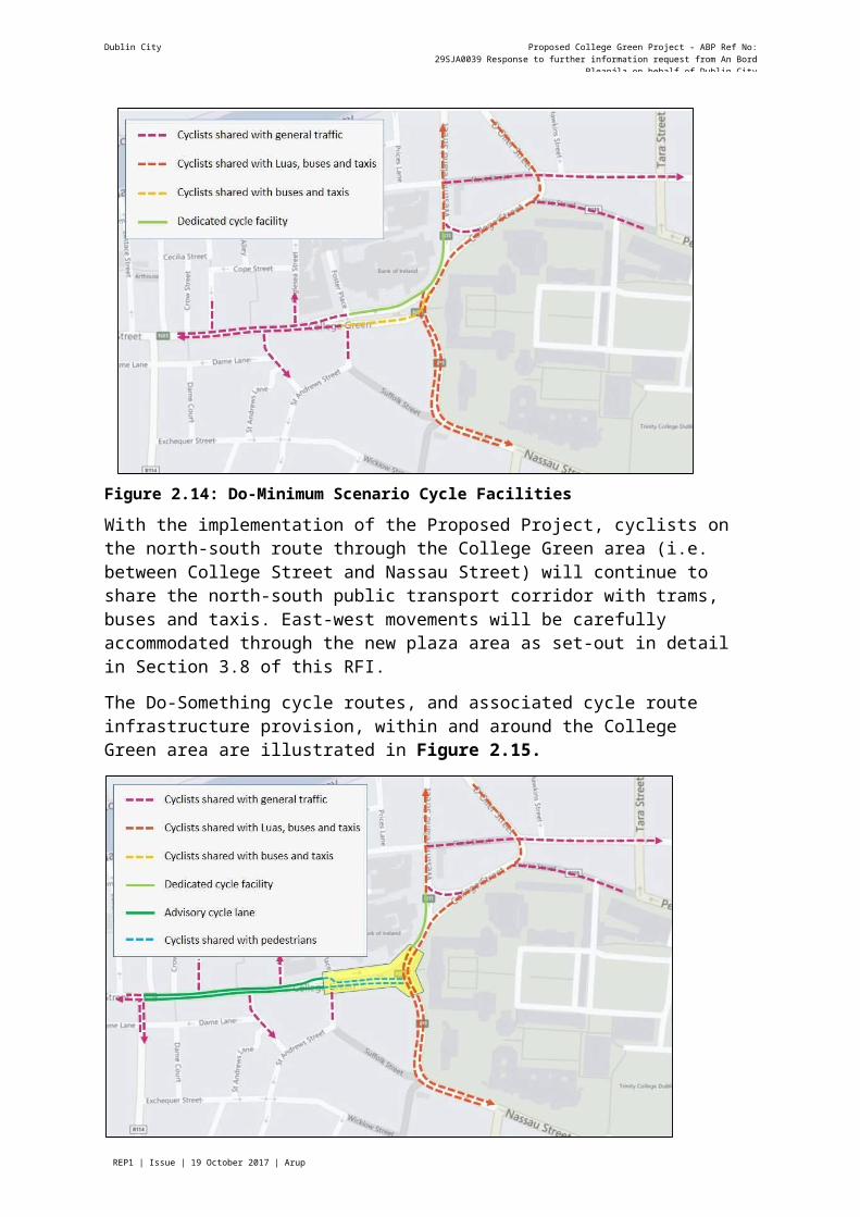
Figure 2.14 illustrates the do-minimum cycle routes, and associated cycle infrastructure provision, within and around the College Green area.
Dublin City Council Proposed College Green Project - ABP Ref No: 29SJA0039 Response to further information request from An Bord Pleanála on behalf of Dublin City
Council
Page REP1 | Issue | 19 October 2017 | Arup
Figure 2.14: Do-Minimum Scenario Cycle Facilities
With the implementation of the Proposed Project, cyclists on the north-south route through the College Green area (i.e. between College Street and Nassau Street) will continue to share the north-south public transport corridor with trams, buses and taxis. East-west movements will be carefully accommodated through the new plaza area as set-out in detail in Section 3.8 of this RFI.
The Do-Something cycle routes, and associated cycle route infrastructure provision, within and around the College Green area are illustrated in Figure 2.15.
Figure 2.15: Proposed Cycle Facilities
Dublin City Council Proposed College Green Project - ABP Ref No: 29SJA0039 Response to further information request from An Bord Pleanála on behalf of Dublin City
Council
Page REP1 | Issue | 19 October 2017 | Arup
It is considered that the removal of vehicular conflicts from the College Green area, along with the addition of cycle lanes on Dame Street will have an overall positive impact on the movement of cyclists within and through the core city centre area.
The proposed cycle route across College Green is not direct for those cyclists travelling in the west-east direction. There are also some sharp turns proposed that will require cyclists to travel very slowly, and therefore safely, while negotiating the various interactions with pedestrians through the plaza.
However, unlike other modes of traffic that will be displaced from College Green, cyclists will benefit from being able to circulate through the plaza without conflicts with motorised vehicles, thus enhancing their quality of service and comfort. The level of service is also improved along adjacent streets, mainly due to reductions in traffic volumes as a result of the Proposed Project.
The pedestrian priority zone of the College Green Plaza is only 60m long from west to east. Even though cyclists will be required to travel slowly at about 10 km/h or less through this space, it will take only 1/2 minute to get through from one side to the other. Compared to the current frequent delays at multiple traffic signals between George's Street and Westmoreland Street, the journey time for cyclists should actually reduce considerably.
On balance therefore, the proposed arrangement with pedestrian priority and a cycle route across the plaza will still provide considerable convenience for cyclists, but in a controlled and safe arrangement that respects the appropriate allocation of priority to pedestrians. A formally designated cycle track with signal-controlled crossings would be less favourable as it would actually increase delay and reduce convenience for both cyclists and pedestrians, as well as being inherently less safe when considering the significant pedestrian activity expected.
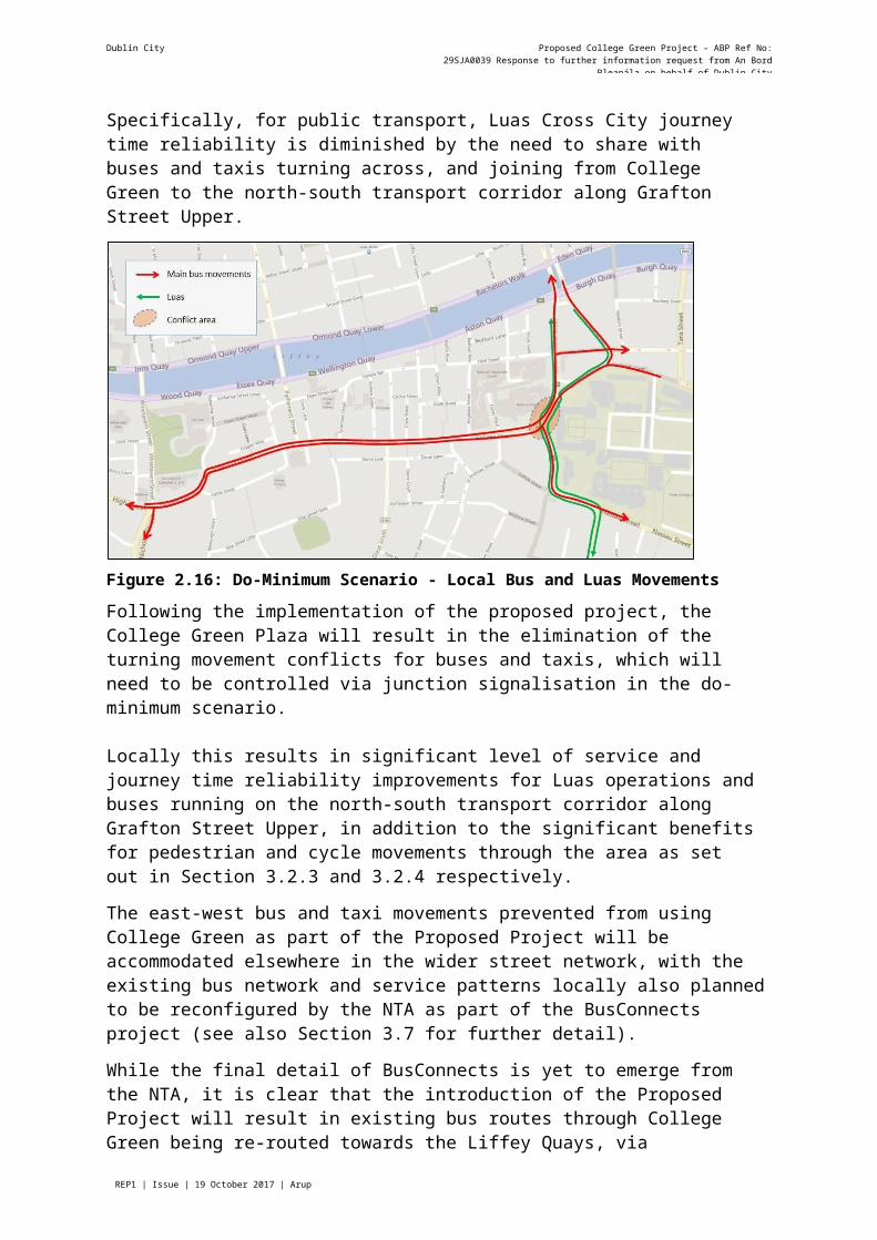
3.2.5 Response to FI Request No. 2 - Impact on Public TransportFigure 2.16 illustrates the local bus and Luas movements on the College Green area in the do-minimum scenario. In this scenario, buses and taxis share the Luas corridor in both directions, but can also traverse College Green from east to west and west to east, linking College Street with Dame Street and west to east linking Dame Street with Westmoreland Street.
There will be no general vehicular access allowed between College Green/Dame Street and Lower Grafton Street and vice-versa.
The do-minimum scenario does therefore include a conflict between bus and taxi vehicles heading towards Dame Street from College Street and those (including the Luas) travelling northbound on College Street-Grafton Street Lower. Bus and taxi vehicles travelling between Dame Street and Westmoreland Street join the northbound Luas corridor at the signal- controlled crossing on College Street. The management of these movements, within the conflict zone, including pedestrians and cyclists crossing through, will be managed via the signal control arrangement as illustrated in Figures 2.1a and 2.1b, in Section 3.2.2.
As a result of the need to manage vehicular movement (i.e. buses and taxis), Luas trans, pedestrians and cyclists within this localised area, the overall result within the do-minimum scenario is effectively a compromised level of service provision for all modes.

Dublin City Council Proposed College Green Project - ABP Ref No: 29SJA0039 Response to further information request from An Bord Pleanála on behalf of Dublin City
Council
Page REP1 | Issue | 19 October 2017 | Arup
Specifically, for public transport, Luas Cross City journey time reliability is diminished by the need to share with buses and taxis turning across, and joining from College Green to the north-south transport corridor along Grafton Street Upper.
Figure 2.16: Do-Minimum Scenario - Local Bus and Luas Movements
Following the implementation of the proposed project, the College Green Plaza will result in the elimination of the turning movement conflicts for buses and taxis, which will need to be controlled via junction signalisation in the do-minimum scenario.
Locally this results in significant level of service and journey time reliability improvements for Luas operations and buses running on the north-south transport corridor along Grafton Street Upper, in addition to the significant benefits for pedestrian and cycle movements through the area as set out in Section 3.2.3 and 3.2.4 respectively.
The east-west bus and taxi movements prevented from using College Green as part of the Proposed Project will be accommodated elsewhere in the wider street network, with the existing bus network and service patterns locally also planned to be reconfigured by the NTA as part of the BusConnects project (see also Section 3.7 for further detail).
While the final detail of BusConnects is yet to emerge from the NTA, it is clear that the introduction of the Proposed Project will result in existing bus routes through College Green being re-routed towards the Liffey Quays, via Winetavern Street on the eastbound direction and via Parliament Street on the westbound direction.
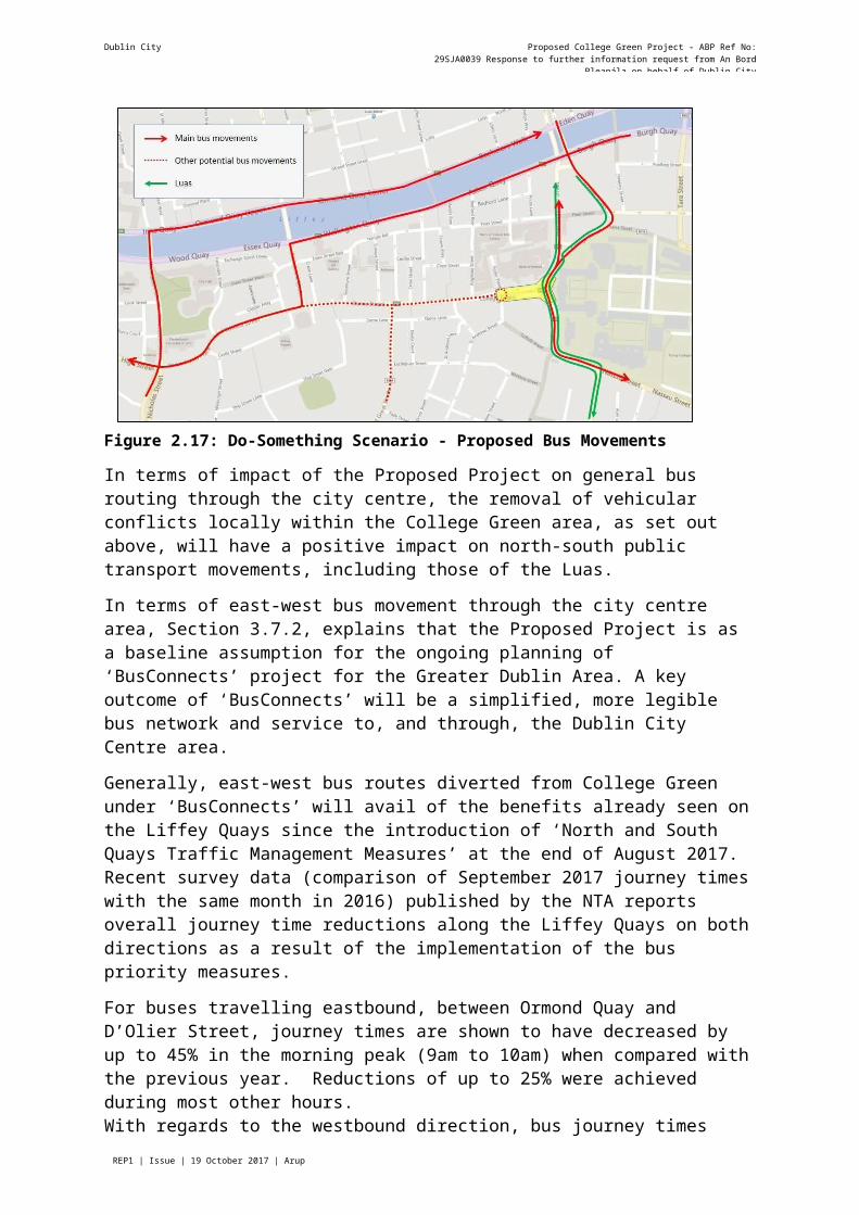
In addition, a number of services will be able to access and terminate at College Green from the west along Dame Street, as illustrated in Figure 2.17.
Dublin City Council Proposed College Green Project - ABP Ref No: 29SJA0039 Response to further information request from An Bord Pleanála on behalf of Dublin City
Council
Page REP1 | Issue | 19 October 2017 | Arup
Figure 2.17: Do-Something Scenario - Proposed Bus Movements
In terms of impact of the Proposed Project on general bus routing through the city centre, the removal of vehicular conflicts locally within the College Green area, as set out above, will have a positive impact on north-south public transport movements, including those of the Luas.
In terms of east-west bus movement through the city centre area, Section 3.7.2, explains that the Proposed Project is as a baseline assumption for the ongoing planning of ‘BusConnects’ project for the Greater Dublin Area. A key outcome of ‘BusConnects’ will be a simplified, more legible bus network and service to, and through, the Dublin City Centre area.
Generally, east-west bus routes diverted from College Green under ‘BusConnects’ will avail of the benefits already seen on the Liffey Quays since the introduction of ‘North and South Quays Traffic Management Measures’ at the end of August 2017. Recent survey data (comparison of September 2017 journey times with the same month in 2016) published by the NTA reports overall journey time reductions along the Liffey Quays on both directions as a result of the implementation of the bus priority measures.
For buses travelling eastbound, between Ormond Quay and D’Olier Street, journey times are shown to have decreased by up to 45% in the morning peak (9am to 10am) when compared with the previous year. Reductions of up to 25% were achieved during most other hours.With regards to the westbound direction, bus journey times measured between Aston Quay and Essex Quay have decreased by as much as 38% in the PM peak period (between 5pm and 6pm).
Within the city centre as a whole, the introduction of the Proposed Project will support a significant improvement in bus service provision, taken in conjunction with the ‘BusConnects’ proposals. As explained above, the bus priority measures implemented in the city centre and particularly along the Liffey Quays have been reflected in significant journey time savings for public transport.
The diversion of the routes from the Dame Street-College Green corridor to the Quays, particularly the eastbound routes, which will be relocated to the North Quays, will have an impact on the walking catchment of the bus stops locally. This was described and assessed in section 6.6.2.3 of the May 2017 EIS.
Dublin City Council Proposed College Green Project - ABP Ref No: 29SJA0039 Response to further information request from An Bord Pleanála on behalf of Dublin City
Council
Page REP1 | Issue | 19 October 2017 | Arup
It is concluded then, that the total number of people within walking distance from a bus stop will increase following the route diversions resulting from the Proposed Project.
It is however considered that the diversion of east-west bus services from the Dame Street- College Green corridor to what is now a high-performance public transport corridor along the Quays, will improve the bus level of service, even considering the impact brought about by the relocation of bus stops.
Locally however, there will be some slight negative impact in terms of public transport accessibility by bus as a result of service diversions form College Green to the Liffey Quays in terms of bus stop locations and walking distances to some origin and destination locations. The additional walk time (between 4 and 5 minutes, depending on the bus stop location) will be offset by the improvements to journey time into and out if the City via the Quays, coupled with potential reductions in wait time likely to come about from the BusConnects project.
With regards to the future potential diversion of northbound buses to Winetavern Street, it is considered that this is likely to have a similar impact to the diversion of westbound buses, as the buses will be subsequently routed via the north Quays, availing of high capacity and relatively short walk times from most city centre destinations.
Impacts on Public Transport – Flows
The NTA has carried-out modelling to assess the proposed changes to the Dublin City Centre public transport networks, as part of the College Green Proposed Project. Within the canal cordon, some changes to public transport networks are apparent. Forecast 2018 public transport passenger flows increase along the Quays in the city centre, which reflects the rerouting that was carried-out to account for the closure of College Green. The full results are detailed in Section 3.4 of the ‘College Green Traffic Management Measures Modelling Report’ in Appendix B of this RFI Response Document and Appendix 6.1 of the EIAR.
The implementation of the Proposed Project will, as discussed, divert the majority of buses that currently route through College Green to the Liffey Quays, both in the eastbound and westbound direction. This is clear in the results from the 2018 model, which show decreases of over 1,500 passengers per direction in the AM peak along College Green and Dame Street, and similar increases along both the north and the south Quays (see Figure 3-29 of appended modelling report).
In the 2035 scenario, the decreases in public transport passenger flows on College Green and Dame Street are less pronounced (in the order to 450 and 650 in the eastbound and westbound direction, respectively) with the increases along the Liffey Quays remaining significant, with up to 800 westbound and 1,300 eastbound (see Figure 3-31 of appended modelling report).
Impacts on Public Transport – Journey Times
The model was also interrogated to identify changes in bus journey times before (do- minimum scenario) and after (do-something scenario) the implementation of the Proposed Project.
The two relevant bus routes analysed (Aircoach and 25B) run along the College Green- Grafton Street Lower corridor, along the Luas line, in both the do-minimum and the do- something scenarios. The do-something scenario shows journey time improvements when compared with the do-minimum in both 2018 and 2035 and in both directions.
Dublin City Council Proposed College Green Project - ABP Ref No: 29SJA0039 Response to further information request from An Bord Pleanála on behalf of Dublin City
Council
Page REP1 | Issue | 19 October 2017 | Arup
More detailed results are presented in the response to item 4 of this RFI, in Section 3.4 of this document.
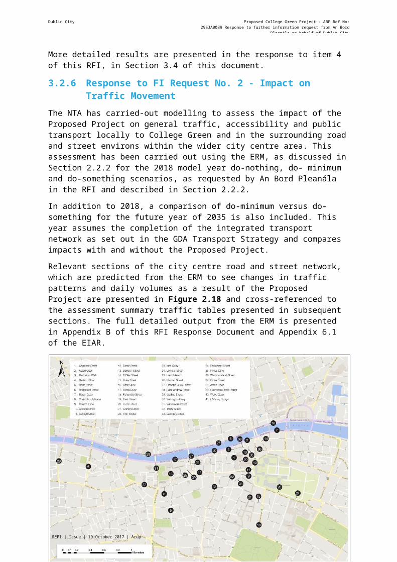
3.2.6 Response to FI Request No. 2 - Impact on Traffic MovementThe NTA has carried-out modelling to assess the impact of the Proposed Project on general traffic, accessibility and public transport locally to College Green and in the surrounding road and street environs within the wider city centre area. This assessment has been carried out using the ERM, as discussed in Section 2.2.2 for the 2018 model year do-nothing, do- minimum and do-something scenarios, as requested by An Bord Pleanála in the RFI and described in Section 2.2.2.
In addition to 2018, a comparison of do-minimum versus do-something for the future year of 2035 is also included. This year assumes the completion of the integrated transport network as set out in the GDA Transport Strategy and compares impacts with and without the Proposed Project.
Relevant sections of the city centre road and street network, which are predicted from the ERM to see changes in traffic patterns and daily volumes as a result of the Proposed Project are presented in Figure 2.18 and cross-referenced to the assessment summary traffic tables presented in subsequent sections. The full detailed output from the ERM is presented in Appendix B of this RFI Response Document and Appendix 6.1 of the EIAR.
Figure 2.18: City Centre Road Network References
Dublin City Council Proposed College Green Project - ABP Ref No: 29SJA0039 Response to further information request from An Bord Pleanála on behalf of Dublin City
Council
Page REP1 | Issue | 19 October 2017 | Arup
3.2.6.1 2018 Model Year AssessmentDo-Nothing vs. Do-Minimum Assessment
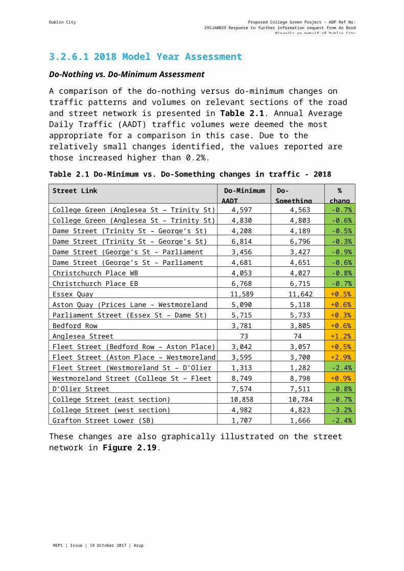
A comparison of the do-nothing versus do-minimum changes on traffic patterns and volumes on relevant sections of the road and street network is presented in Table 2.1. Annual Average Daily Traffic (AADT) traffic volumes were deemed the most appropriate for a comparison in this case. Due to the relatively small changes identified, the values reported are those increased higher than 0.2%.
Table 2.1 Do-Minimum vs. Do-Something changes in traffic - 2018
Street Link Do-Minimum AADT volumes
Do-Something AADT volumes
%change
College Green (Anglesea St – Trinity St) westbound (WB) 4,597 4,563 -0.7%College Green (Anglesea St – Trinity St) eastbound (EB) 4,830 4,803 -0.6%Dame Street (Trinity St – George’s St) WB 4,208 4,189 -0.5%Dame Street (Trinity St – George’s St) EB 6,814 6,796 -0.3%Dame Street (George’s St – Parliament St) WB 3,456 3,427 -0.9%Dame Street (George’s St – Parliament St) EB 4,681 4,651 -0.6%Christchurch Place WB 4,053 4,027 -0.8%Christchurch Place EB 6,768 6,715 -0.7%Essex Quay 11,589 11,642 +0.5%Aston Quay (Prices Lane – Westmoreland St) 5,090 5,118 +0.6%Parliament Street (Essex St – Dame St) 5,715 5,733 +0.3%Bedford Row 3,781 3,805 +0.6%Anglesea Street 739 748 +1.2%Fleet Street (Bedford Row – Aston Place) 3,042 3,057 +0,5%Fleet Street (Aston Place – Westmoreland St) 3,595 3,700 +2.9%Fleet Street (Westmoreland St – D’Olier St) 1,313 1,282 -2.4%Westmoreland Street (College St – Fleet St) 8,749 8,798 +0.9%D’Olier Street 7,574 7,511 -0.8%College Street (east section) 10,858 10,784 -0.7%College Street (west section) 4,982 4,823 -3.2%Grafton Street Lower (SB) 1,707 1,666 -2.4%
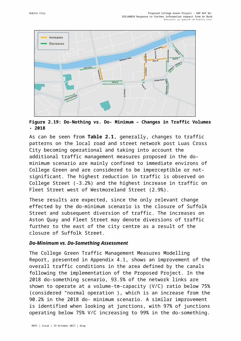
These changes are also graphically illustrated on the street network in Figure 2.19.

Dublin City Council Proposed College Green Project - ABP Ref No: 29SJA0039 Response to further information request from An Bord Pleanála on behalf of Dublin City
Council
Page REP1 | Issue | 19 October 2017 | Arup
Figure 2.19: Do-Nothing vs. Do- Minimum – Changes in Traffic Volumes - 2018
As can be seen from Table 2.1, generally, changes to traffic patterns on the local road and street network post Luas Cross City becoming operational and taking into account the additional traffic management measures proposed in the do-minimum scenario are mainly confined to immediate environs of College Green and are considered to be imperceptible or not-significant. The highest reduction in traffic is observed on College Street (-3.2%) and the highest increase in traffic on Fleet Street west of Westmoreland Street (2.9%).
These results are expected, since the only relevant change effected by the do-minimum scenario is the closure of Suffolk Street and subsequent diversion of traffic. The increases on Aston Quay and Fleet Street may denote diversions of traffic further to the east of the city centre as a result of the closure of Suffolk Street.
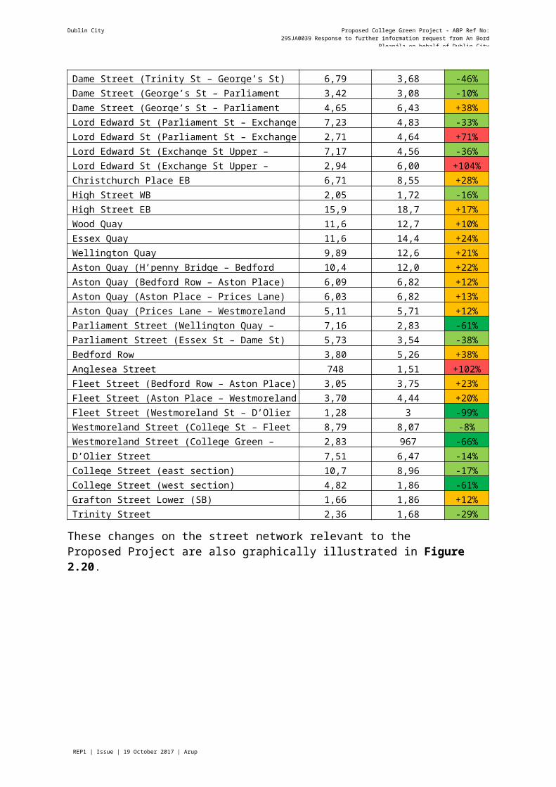
Do-Minimum vs. Do-Something Assessment
The College Green Traffic Management Measures Modelling Report, presented in Appendix 4.1, shows an improvement of the overall traffic conditions in the area defined by the canals following the implementation of the Proposed Project. In the 2018 do-something scenario, 93.5% of the network links are shown to operate at a volume-to-capacity (V/C) ratio below 75% (considered “normal operation”), which is an increase from the 90.2% in the 2018 do- minimum scenario. A similar improvement is identified when looking at junctions, with 97% of junctions operating below 75% V/C increasing to 99% in the do-something.
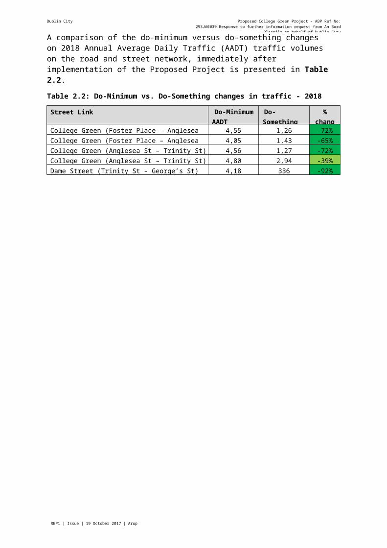
A comparison of the do-minimum versus do-something changes on 2018 Annual Average Daily Traffic (AADT) traffic volumes on the road and street network, immediately after implementation of the Proposed Project is presented in Table 2.2.
Table 2.2: Do-Minimum vs. Do-Something changes in traffic - 2018
Street Link Do-Minimum AADT volumes
Do-Something AADT volumes
%change
College Green (Foster Place – Anglesea St) WB 4,557 1,267 -72%College Green (Foster Place – Anglesea St) EB 4,057 1,430 -65%College Green (Anglesea St – Trinity St) WB 4,563 1,272 -72%College Green (Anglesea St – Trinity St) EB 4,803 2,945 -39%Dame Street (Trinity St – George’s St) WB 4,189 336 -92%
Dublin City Council Proposed College Green Project - ABP Ref No: 29SJA0039 Response to further information request from An Bord Pleanála on behalf of Dublin City
Council
Page REP1 | Issue | 19 October 2017 | Arup
Dame Street (Trinity St – George’s St) EB 6,796 3,689 -46%Dame Street (George’s St – Parliament St) WB 3,427 3,089 -10%Dame Street (George’s St – Parliament St) EB 4,651 6,435 +38%Lord Edward St (Parliament St – Exchange St Upper) WB 7,230 4,833 -33%Lord Edward St (Parliament St – Exchange St Upper) EB 2,717 4,642 +71%Lord Edward St (Exchange St Upper – Fishamble St) WB 7,173 4,560 -36%Lord Edward St (Exchange St Upper – Fishamble St) EB 2,946 6,003 +104%Christchurch Place EB 6,715 8,559 +28%High Street WB 2,053 1,728 -16%High Street EB 15,927 18,715 +17%Wood Quay 11,642 12,798 +10%Essex Quay 11,642 14,408 +24%Wellington Quay 9,897 12,644 +21%Aston Quay (H’penny Bridge – Bedford Row) 10,460 12,093 +22%Aston Quay (Bedford Row – Aston Place) 6,090 6,824 +12%Aston Quay (Aston Place – Prices Lane) 6,039 6,824 +13%Aston Quay (Prices Lane – Westmoreland St) 5,118 5,711 +12%Parliament Street (Wellington Quay – Essex St) 7,165 2,830 -61%Parliament Street (Essex St – Dame St) 5,733 3,542 -38%Bedford Row 3,805 5,268 +38%Anglesea Street 748 1,511 +102%Fleet Street (Bedford Row – Aston Place) 3,057 3,757 +23%Fleet Street (Aston Place – Westmoreland St) 3,700 4,445 +20%Fleet Street (Westmoreland St – D’Olier St) 1,282 3 -99%Westmoreland Street (College St – Fleet St) 8,798 8,075 -8%Westmoreland Street (College Green – College St) 2,833 967 -66%D’Olier Street 7,511 6,478 -14%College Street (east section) 10,784 8,960 -17%College Street (west section) 4,823 1,862 -61%Grafton Street Lower (SB) 1,666 1,862 +12%Trinity Street 2,367 1,682 -29%
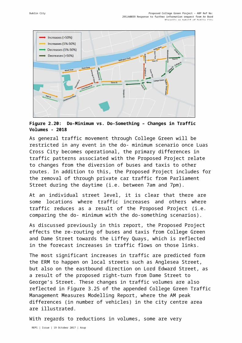
These changes on the street network relevant to the Proposed Project are also graphically illustrated in Figure 2.20.

Dublin City Council Proposed College Green Project - ABP Ref No: 29SJA0039 Response to further information request from An Bord Pleanála on behalf of Dublin City
Council
Page REP1 | Issue | 19 October 2017 | Arup
Figure 2.20: Do-Minimum vs. Do-Something – Changes in Traffic Volumes - 2018
As general traffic movement through College Green will be restricted in any event in the do- minimum scenario once Luas Cross City becomes operational, the primary differences in traffic patterns associated with the Proposed Project relate to changes from the diversion of buses and taxis to other routes. In addition to this, the Proposed Project includes for the removal of through private car traffic from Parliament Street during the daytime (i.e. between 7am and 7pm).
At an individual street level, it is clear that there are some locations where traffic increases and others where traffic reduces as a result of the Proposed Project (i.e. comparing the do- minimum with the do-something scenarios).
As discussed previously in this report, the Proposed Project effects the re-routing of buses and taxis from College Green and Dame Street towards the Liffey Quays, which is reflected in the forecast increases in traffic flows on those links.
The most significant increases in traffic are predicted form the ERM to happen on local streets such as Anglesea Street, but also on the eastbound direction on Lord Edward Street, as a result of the proposed right-turn from Dame Street to George’s Street. These changes in traffic volumes are also reflected in Figure 3.25 of the appended College Green Traffic Management Measures Modelling Report, where the AM peak differences (in number of vehicles) in the city centre area are illustrated.
With regards to reductions in volumes, some are very significant, within the immediate vicinity of College Green (Dame Street, Trinity Street, College Street, Fleet Street East). Changes to traffic management on Parliament Street (public transport only from 7am to 7pm) are also reflected in notable reductions in traffic volumes.
3.2.6.2 2035 Model Year AssessmentDo-Minimum vs. Do-Something Assessment
A comparison between the do-minimum and the do-something for 2035 for the canal cordon area shows a negligible impact of the Proposed Project on the prevalent volume-to-capacity (V/C) ratios. An insignificant decrease in V/C ratios from 90.2% to 89.8% of links below 75%V/C is identified in the College Green Traffic Management Measures Draft Modelling
Dublin City Council Proposed College Green Project - ABP Ref No: 29SJA0039 Response to further information request from An Bord Pleanála on behalf of Dublin City
Council
Page REP1 | Issue | 19 October 2017 | Arup
Report (Appendix 4.1). Looking at junction performance, the decrease is also insignificant, with 97% under 75% in the do-minimum and 96.6% in the do-something.
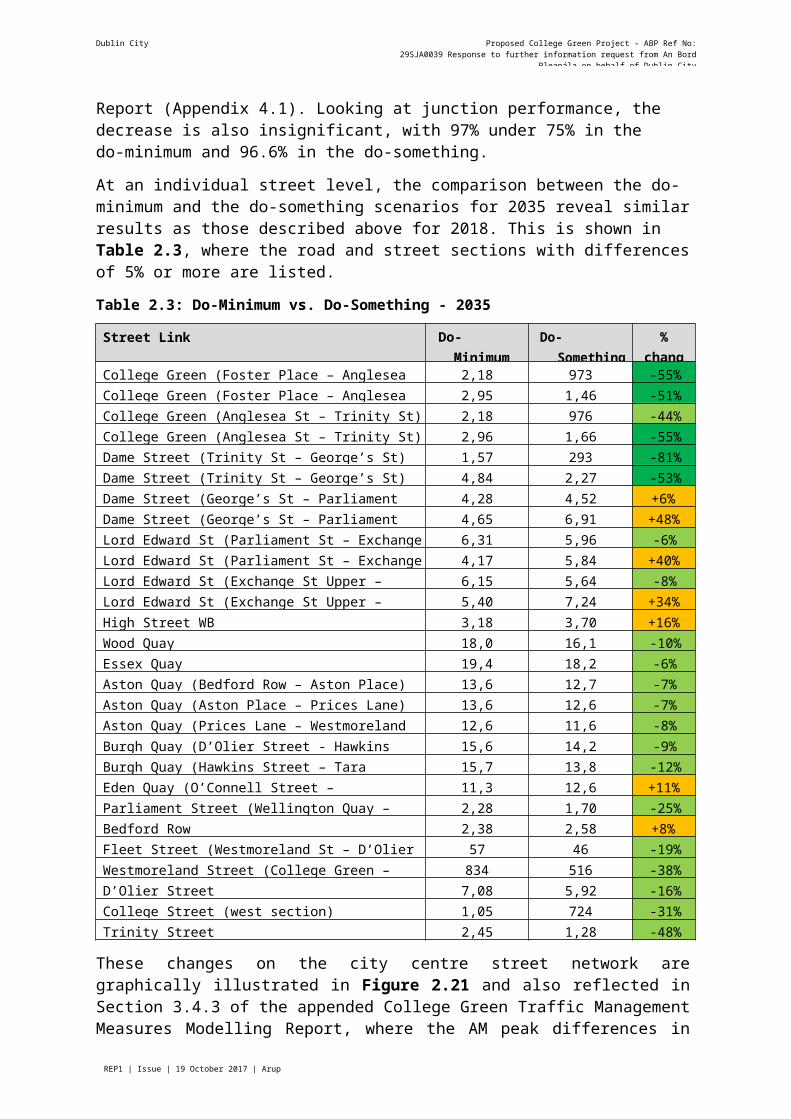
At an individual street level, the comparison between the do-minimum and the do-something scenarios for 2035 reveal similar results as those described above for 2018. This is shown in Table 2.3, where the road and street sections with differences of 5% or more are listed.
Table 2.3: Do-Minimum vs. Do-Something - 2035
Street Link Do-Minimum volumes
Do-Something volumes
%change
College Green (Foster Place – Anglesea St) WB 2,186 973 -55%College Green (Foster Place – Anglesea St) EB 2,957 1,464 -51%College Green (Anglesea St – Trinity St) WB 2,189 976 -44%College Green (Anglesea St – Trinity St) EB 2,968 1,667 -55%Dame Street (Trinity St – George’s St) WB 1,574 293 -81%Dame Street (Trinity St – George’s St) EB 4,847 2,271 -53%Dame Street (George’s St – Parliament St) WB 4,284 4,527 +6%Dame Street (George’s St – Parliament St) EB 4,656 6,914 +48%Lord Edward St (Parliament St – Exchange St Upper) WB 6,316 5,966 -6%Lord Edward St (Parliament St – Exchange St Upper) EB 4,173 5,849 +40%Lord Edward St (Exchange St Upper – Fishamble St) WB 6,153 5,642 -8%Lord Edward St (Exchange St Upper – Fishamble St) EB 5,404 7,240 +34%High Street WB 3,182 3,700 +16%Wood Quay 18,014 16,173 -10%Essex Quay 19,416 18,289 -6%Aston Quay (Bedford Row – Aston Place) 13,695 12,750 -7%Aston Quay (Aston Place – Prices Lane) 13,644 12,699 -7%Aston Quay (Prices Lane – Westmoreland St) 12,626 11,605 -8%Burgh Quay (D’Olier Street - Hawkins Street) 15,633 14,207 -9%Burgh Quay (Hawkins Street – Tara Street) 15,746 13,871 -12%Eden Quay (O’Connell Street – Marlborough Street) 11,360 12,633 +11%Parliament Street (Wellington Quay – Essex St) 2,287 1,708 -25%Bedford Row 2,381 2,580 +8%Fleet Street (Westmoreland St – D’Olier St) 57 46 -19%Westmoreland Street (College Green – College St) 834 516 -38%D’Olier Street 7,084 5,923 -16%College Street (west section) 1,055 724 -31%Trinity Street 2,456 1,288 -48%
These changes on the city centre street network are graphically illustrated in Figure 2.21 and also reflected in Section 3.4.3 of the appended College Green Traffic Management Measures Modelling Report, where the AM peak differences in numbers of vehicles are shown.

Dublin City Council Proposed College Green Project - ABP Ref No: 29SJA0039 Response to further information request from An Bord Pleanála on behalf of Dublin City
Council
Page REP1 | Issue | 19 October 2017 | Arup
Figure 2.21: Do-Minimum vs. Do-Something – Changes in Traffic Volumes - 2035
The differences between the do-minimum and the do-something scenarios in 2035 are somewhat similar to those described previously in relation to the 2018 scenarios. Traffic volume reductions are notable on College Green and parts of Dame Street, as well as on D’Olier Street, Westmoreland Street and College Street. The changes along the Liffey Quays are less pronounced than in 2018, with the south Quays denoting some small reductions in traffic.
With regards to increases in traffic volumes, the street links where this is the case include Bedford Row, Lord Edward Street (eastbound), Dame Street (both directions between George’s Street and Parliament Street). The latter streets, particularly in the eastbound direction are likely to see increased traffic due to the proposed right-turn onto Georges Street from Dame Street.
3.2.6.3 Vehicular Journey TimesThe response to RFI item 4 discusses this aspect in more detail, but analysis carried-out by the NTA using the ERM model for the do-minimum and do-something scenarios shows improvements in the vehicular journey times on both the selected east-west and north-south routes.
3.2.7 Response to FI Request No. 2 - Impact on Access to Car ParkingBoth College Green and the area immediately surrounding, does not cater for any significant numbers of on-street car parking, which is typical of a city centre environment where visitors by car are directed towards managed off-street parking. As such, the Proposed Project will have a negligible impact on on-street parking activity within the city centre.
The following two multi-storey car parks in the vicinity of the Proposed Project have been assessed:
Trinity Street Car Park; and Fleet Street Car Park.
Figure 2.22 illustrates the current access and egress routes for each car park, also being applicable to both the do-minimum scenario and the do-nothing scenario.
Dublin City Council Proposed College Green Project - ABP Ref No: 29SJA0039 Response to further information request from An Bord Pleanála on behalf of Dublin City
Council
Page REP1 | Issue | 19 October 2017 | Arup
Figure 2.22: Access to Car Parks
While the current traffic management arrangements on College Green (through enforcement of the College Green Bus Gate) allows for some off peak general traffic through movement, once Luas Cross City becomes operational, in both the do-nothing and do-minimum scenarios, College Green will cease to become an access route for all general traffic, including to the off-street car parks.
The recent right turn ban from Bachelors Walk on the north quays of the River Liffey onto O’Connell Bridge, which came into effect as part of the ‘North and South Quays Traffic Management Measures’ project in August 2017, has added a further specific restriction on access to the Fleet Street Car Park from the west (i.e. via the north Quays).
Access routes to and from these car parks in the do-something scenario, on implementation of the Proposed Project is illustrated in Figure 2.23.

Dublin City Council Proposed College Green Project - ABP Ref No: 29SJA0039 Response to further information request from An Bord Pleanála on behalf of Dublin City
Council
Page REP1 | Issue | 19 October 2017 | Arup
Figure 2.23: Proposed Car-Park Access
By comparing the do-minimum and do-something car park access arrangements in Figure2.22 and Figure 2.23 respectively, it is clear that there will not be any direct impact from the Proposed Project on access and egress routes to either the Trinity Street or Fleet Street car parks.
3.2.8 Response to FI Request No. 2 - Impact on Access to Loading/Unloading Facilities
The College Green project proposes a formalisation of loading and unloading facilities in the area, including the retention of one of the present loading bays on Andrew’s Street in addition to three new time-limited areas on Dame Street, Trinity Street and Church Lane, as illustrated in Figure 2.24.
Dublin City Council Proposed College Green Project - ABP Ref No: 29SJA0039 Response to further information request from An Bord Pleanála on behalf of Dublin City
Council
Page REP1 | Issue | 19 October 2017 | Arup
Figure 2.24: Existing and Proposed Time-Limited Loading bays
College Green
There are presently no dedicated service areas accessed directly off College Green. There are, however commercial premises along the southern edge of College Green that need to be serviced from the street.
Presently this is done on a time-limited basis, utilising the bus stops located along College Green. As illustrated in Figure 2.25, access is obtained from Dame Street availing of a U- turn on College Green with egress towards the west along Dame Street.
Figure 2.25: Existing Access to Loading/Unloading facilities - College Green
As a result of the proposed project, the commercial premises to the east of Church Lane will cease to have direct road access but will avail of a time-limited loading bay on Church Lane. Access and egress will continue to only be possible from and to Dame Street.
Dublin City Council Proposed College Green Project - ABP Ref No: 29SJA0039 Response to further information request from An Bord Pleanála on behalf of Dublin City
Council
Page REP1 | Issue | 19 October 2017 | Arup
The pedestrianised College Green will enable occasional vehicular use, including along its southern edge. The future service access and egress is illustrated in Figure 2.26
Figure 2.26: Proposed access to loading/unloading facilities - College Green
Dame Street
Dame Street has numerous commercial premises along both its southern and northern edges, which need to be serviced on a regular basis. Presently this is done from the street itself with access and egress to/from the western end of Dame Streets as well as from South Great George’s Street, as illustrated in Figure 2.27.
Figure 2.27: Existing access to loading/unloading facilities- Dame Street
Following the implementation of the Proposed Project, vehicles will cease to be able to access Dame Street from the College Green side, and therefore access to the southern frontages and egress from the northern frontages will rely on the Turning Circle opposite Foster Place and Church Lane that is included in the proposals.
Dublin City Council Proposed College Green Project - ABP Ref No: 29SJA0039 Response to further information request from An Bord Pleanála on behalf of Dublin City
Council
Page REP1 | Issue | 19 October 2017 | Arup
Figure 2.28: Proposed access to loading/unloading facilities- Dame Street
Anglesea Street – Cope Street – Fownes Street Upper
These streets operate a one-way system off Dame Street that enables service access to the former Central Bank building, as well as to a number of commercial premises locally and beyond in the Temple Bar area.
Figure 2.29 shows the existing circulation required, which due to a banned right turn at the junction of Fownes Street Upper and Dame Street, includes the need for vehicles to circulate around the one-way system of Trinity Street, Andrew Street and Church Lane before heading westwards along Dame Street.
Figure 2.29: Existing access to loading/unloading facilities - Anglesea Street-Cope Street-Fownes Street Upper
Dublin City Council Proposed College Green Project - ABP Ref No: 29SJA0039 Response to further information request from An Bord Pleanála on behalf of Dublin City
Council
Page REP1 | Issue | 19 October 2017 | Arup
Following the implementation of the Proposed Project, there will be no alteration to the existing servicing routes to these particular streets, as illustrated on Figure 2.30.
Figure 2.30: Proposed access to loading/unloading facilities-Anglesea Street – Cope Street – Fownes Street Upper
Trinity Street – Andrew Street – Church Lane
Similarly, the access to these streets is presently made along a counter-clockwise one-way system off Dame Street. This will continue to be the case following the implementation of the proposed project for College Green, as illustrated in Figures 2.31 and 2.32.
Figure 2.31: Existing access to loading/unloading facilities Trinity Street – Andrew Street – Church Lane
Dublin City Council Proposed College Green Project - ABP Ref No: 29SJA0039 Response to further information request from An Bord Pleanála on behalf of Dublin City
Council
Page REP1 | Issue | 19 October 2017 | Arup
Figure 2.32: Proposed access to loading/unloading facilities Trinity Street – Andrew Street – Church Lane
Parliament Street
The traffic management changes proposed for Parliament Street as part of the Proposed Project will also result in changes to the manner in which loading/unloading operations take place presently, particularly in relation to access and egress.
Presently, service vehicles avail of two small loading bays on either side of Parliament Street and a loading area on Essex Street East, close to the junction with Parliament Street. These can be accessed from Grattan Bridge or from Exchange Street Lower-Essex Gate. Access via Essex Street West is also possible, but only up to 11am, time at which this street becomes pedestrian-only.
Egress is achieved via Lord Edward Street for those vehicles using the Parliament Street loading bays, and via Essex Street East, Temple Bar, Eustace Street and Wellington Quay for those using Essex Street East to load/unload. These routes are illustrated in Figure 2.33.
Dublin City Council Proposed College Green Project - ABP Ref No: 29SJA0039 Response to further information request from An Bord Pleanála on behalf of Dublin City
Council
Page REP1 | Issue | 19 October 2017 | Arup
Figure 2.33: Existing access to loading/unloading facilities – Parliament Street
The Proposed Project does not allow general traffic on Parliament Street between the hours of 7am and 7pm. During this period, the street is proposed to operate as a public transport only route.
However, and in order to mitigate the loss of access to the Parliament Street loading bays during the day, it is proposed that a deliveries-only right-turn is retained on Essex Gate up to 11am, thus allowing for service vehicles to continue access from Exchange Street Lower- Essex Gate. These proposals are shown in Figure 2.34.
Dublin City Council Proposed College Green Project - ABP Ref No: 29SJA0039 Response to further information request from An Bord Pleanála on behalf of Dublin City
Council
Page REP1 | Issue | 19 October 2017 | Arup
Figure 2.34 Retained Time-Limited Service Access off Essex Gate
Only public transport will be allowed on to the northern section of Parliament Street, and therefore loading/unloading access will be only possible via the alternative route described above. This will ensure that no rat-running takes place and the service vehicles movements present on Parliament Street itself will be kept to a minimum, catering for local needs only before 11am.
The proposed access and egress routes to Parliament Street are illustrated in Figure 2.35.
Figure 2.35: Proposed access to loading/unloading facilities – Parliament Street
Dublin City Council Proposed College Green Project - ABP Ref No: 29SJA0039 Response to further information request from An Bord Pleanála on behalf of Dublin City
Council
Page REP1 | Issue | 19 October 2017 | Arup
Essex Street West
This street does not avail of dedicated loading bays, but it has a number of businesses (on Essex Street West and on the adjacent pedestrianised Cow’s Lane) which could be affected by the traffic management proposed for Parliament Street.
As shown in Figure 2.36, access to this street is only achieved off Fishamble Street, which in turn is accessed off Essex Quay or Lord Edward Street/Christchurch Place. Egress is via either Parliament Street and back to Lord Edward Street or via Essex Street East, Temple Bar, Eustace Street and Wellington Quay.
Figure 2.36: Existing and proposed access to loading/unloading facilities – Essex Street West
The proposal to retain a deliveries-only right-turn on Essex Gate onto Parliament Street before 11am means that the access and egress options for this particular street will remain as at present.
Essex Street East
Essex Street East presently avails of a formal loading bay near its junction with Parliament Street, but loading/unloading activity talks place along its length as far as Temple Bar.Access is either achieved off Parliament Street, which in turn is accessed via Grattan Bridge, or via Exchange Street Lower-Essex Gate. Egress is made via Eustace Street onto Wellington Quay, as shown in Figure 2.37.
Dublin City Council Proposed College Green Project - ABP Ref No: 29SJA0039 Response to further information request from An Bord Pleanála on behalf of Dublin City
Council
Page REP1 | Issue | 19 October 2017 | Arup
Figure 2.37: Existing access to loading/unloading facilities – Essex Street East
The closure of the northern section of Parliament Street between 7am and 7pm to all vehicles except public transport, will force service vehicles onto Fishamble Street, from where they can access Essex Street East via Exchange Street Lower and Essex Gate. There are no changes to the egress route as a result of the proposed traffic management proposals.
Figure 2.38: Proposed access to loading/unloading facilities – Essex Street East

Dublin City Council Proposed College Green Project - ABP Ref No: 29SJA0039 Response to further information request from An Bord Pleanála on behalf of Dublin City
Council
Page REP1 | Issue | 19 October 2017 | Arup
3.2.9 Response to FI Request No. 2 - Impact on Access to Commercial Premises and Residents
Presently, there is very limited direct vehicular access to commercial premises and to local residential uses in the city centre area. Access largely relies on loading areas and on multi- storey car parking, respectively.
Therefore, the impacts on access to car parking and to loading/unloading facilities described in the previous sections is fully applicable to the access to both commercial premises and to local residential uses.
However, it is considered that the Proposed Project will have significant positive impacts on the pedestrian accessibility throughout the area, by enabling improved permeability and pedestrian comfort at College Green, as well as improvements on the adjacent street network by means of reductions in traffic flows.
3.2.10 Response to FI Request No. 2 - Addressing of 3rd Party Observations
Item 2 of the request for Further Information reflects a number of concerns and calls for clarification raised by third-parties. It is believed that the responses provided within the previous section clearly set-out the many positive and negligible negative impacts that the proposed project will have on pedestrian, cycle and public transport networks, as well as on the vehicular access to commercial premises and car parking.
Dublin City Council Proposed College Green Project - ABP Ref No: 29SJA0039 Response to further information request from An Bord Pleanála on behalf of Dublin City
Council
Page REP1 | Issue | 19 October 2017 | Arup
3.3 Further Information Request No.33.3.1 Question raisedProvide details of existing pedestrian and cyclist daily maximum and seasonal flows within the area and projections for 2018 and 2035.
3.3.2 Response to Further Information Request No. 33.3.2.1 Pedestrian Flows
Details of existing pedestrian daily maximum flows within the area and projections for 2018 and 2035 are provided in Table 3.1. The information is based on pedestrian counts undertaken at College Green in May 2015 and May 2017. The projected 2035 data is based on a 0.9% annual increase for 17 years (growth taken from M2F2 scenario, CSO forecast tables for Dublin).
Table 3.1: College Green Pedestrian Summary- Daily Maximum Flows
Pedestrians Existing 2017 maximum daily flows
Projected 2018 maximum daily flows
Projected 2035 maximum daily flows
College Green at Bank of Ireland 41,010 43,864 51,115
Outside Trinity 49,178 52,601 61,297
Total 90,188 96,465 112,412
No seasonal flow data available at College Green. To demonstrate the assumed seasonal flows in this area, data from the nearest relevant footfall counter at Grafton Street has been used.
Figure 3.1 shows the daily flows between September 2016 and September 2017 at Grafton Street. An increase in pedestrians between September and December is evident, with December being the peak month for pedestrian flows (approximately 81,000 highest recorded). Seasonal pedestrian flows are expected to be similar in the future scenarios.
3.3.2.1 Cyclist Flows
Details of existing cyclist daily maximum flows within the area and projections for 2018 and 2035 are provided in Table 3.2.
Table 3.2: College Green Cyclist Summary- Daily Maximum Flows
Cyclists Existing 2017 maximum daily flows
Projected 2018 maximum daily flows
Projected 2035 maximum daily flows
West-East 3,590 3,885 4,527
East-West 3,024 3,273 3,814North-South 2,221 2,403 2,800Total 8,835 9,561 11,141
There is no seasonal cycle flow data available at College Green. The closest available data on seasonal cyclist flows is from the Grove Road Totem along the Grand Canal. The daily seasonal flows from September 2016 to September 2017 are shown on Figure 3.2 below.
Dublin City Council Proposed College Green Project - ABP Ref No: 29SJA0039 Response to further information request from An Bord Pleanála on behalf of Dublin City
Council
Page REP1 | Issue | 19 October 2017 | Arup
No significant variation is observed throughout the year and a similar trend would be expected at College Green. Seasonal cyclist flows are expected to be similar in the future scenarios.
Dublin City Proposed College Green Project - ABP Ref No:
Page REP1 | Issue | 19 October 2017 | Arup
Figure 3.1 Seasonal Pedestrian Flows at Grafton Street, 2016/2017
Dublin City Proposed College Green Project - ABP Ref No:
Page REP1 | Issue | 19 October 2017 | Arup
Figure 3.2 Seasonal Cycle Flows from the Grove Road Totem along the Grand Canal, 2016/2017
Dublin City Proposed College Green Project - ABP Ref No: 29SJA0039 Response to further information request from An Bord Pleanála on
Page REP1 | Issue | 19 October 2017 | Arup
3.4 Further Information Request No.43.4.1 Question raised“Provide details of current and modelled journey times for buses and other vehicles (peak/off peak) along a west-east axis between Heuston Station and Shelbourne Park greyhound stadium and along a north-south axis between the Mater Hospital and Leeson St Bridge”
3.4.2 Response to Further Information Request No. 4The current and modelled vehicular journey times (peak/off peak) along a west-east axis between Heuston Station and Shelbourne Park greyhound stadium and along a north-south axis between the Mater Hospital and Leeson Street Bridge are provided in Table 4.1 and Table 4.2 respectively.
The future journey times (do-minimum and do-something scenarios) have been derived from the NTA modelling. The modelled AM peak journey times have been selected as the most representative of the peak scenario in this case.
The data representing the current situation has been derived from Dublin City Council Journey Time calculators, based on journey time measurements taken in February 2017, and therefore it is not directly comparable with the outputs of the ERM.
Table 4.1: Current and future vehicular journey times (2018)
Route
Current Do-minimum Do-something
peak off-peak peak off-peak peak off-peak
Mater Hospital to Leeson St Bridge 35 mins 22 mins 23 mins 16 mins 25 mins 16 mins
Leeson St Bridge to Mater Hospital 22 mins 18 mins 18 mins 14 mins 19 mins 14 mins
Heuston Station to Shelbourne Park 30 mins 24 mins 25 mins 14 mins 25 mins 14 mins
Shelbourne Park to Heuston Station 17 mins 20 mins 23 mins 14 mins 26 mins 14 mins
The above journey times are applicable to all vehicles interacting with the routes chosen. However, since there are no existing bus routes that coincide fully with the routes, it was deemed useful the comparison of journey time between the do-minimum and the do- something scenarios on selected north-south and east-west bus routes. The do-nothing scenario was also modelled for comparison purposes, albeit not intended to represent the existing situation.
The routes chosen were: The Aircoach bus service on its section between the canals; and the Dublin Bus service 25B, which runs along the Quays and the College Green area. Table 4.2 presents the outputs of this analysis for the AM peak.
Dublin City Proposed College Green Project - ABP Ref No: 29SJA0039 Response to further information request from An Bord Pleanála on
Page REP1 | Issue | 19 October 2017 | Arup
Table 4.2: Modelled bus journey times (2018)
Route Do-nothing Do-minimum Do-something
Aircoach - Northbound 24 mins 22 mins 22 mins
Aircoach - Southbound 23 mins 23 mins 22 mins
25A Eastbound 15 mins 16 mins 17 mins
25A Westbound 19 mins 20 mins 17 mins
3.5 Further Information Request No. 53.5.1 Question raised“The applicant is requested to elaborate on the vibration impacts associated with increased bus use on the structural stability of buildings on Parliament Street, which are stated to contain basements extending out under the roadway.”
3.5.2 Response to Further Information Request No. 53.5.2.1 Introduction
In response to Item 5 of the Board’s request for further information, a GPR survey of Parliament Street has been undertaken. This is attached as Appendix C of this FI response. The GPR survey identifies that some basements associated with properties on Parliament Street extend up to 1.6m under the carriageway. This has been confirmed by a GPR survey carried out by Dublin City Council. A number of submissions relate to concerns around vibration impacts on structural stability due to the increased number of buses.
3.5.2.2 Relevant guidance
BS7385-2: 1993 ‘Evaluation and measurement for vibration in buildings – Part 2: Guide to damage levels from groundbourne vibration’ (British Standards Institution, 1993), provides guideline values for cosmetic damage to buildings. BS 7385 states that there should typically be no cosmetic damage if transient vibration does not exceed 15mm/s at low frequencies rising to 20mm/s at 15Hz and 50mm/s at 40Hz and above. The standard states that these guidelines relate to relatively modern buildings and should be reduced to 50% or less for more critical buildings.
Road traffic tends to produce vibrations with frequencies predominantly in the range from 5 to 25 Hz. Therefore, a reasonable stringent guideline value in this instance would be 7.5mm/s.
3.5.2.3 Baseline Environment
On 26 September 2017, vibration monitoring was carried out at the façade of a number of buildings on Parliament Street during peak morning traffic.
Dublin City Proposed College Green Project - ABP Ref No: 29SJA0039 Response to further information request from An Bord Pleanála on
Page REP1 | Issue | 19 October 2017 | Arup
The monitoring report is contained in Appendix D and results summarised in Table 5.1 Refer to Figure 5.1 for monitoring locations.
Table 5.1: Vibration monitoring results
Time Location Peak particle velocity (mm/s)
8.00-8.30am V1 0.425
8.30-8.50am V2 0.4
8.52-9.12am V3 0.6
9.12-9.32am V4 1.15
9.42-10.02am V5 0.675
10.02-10.22 V6 0.4
10.23-10.45am V7 2.75
10.45-11.05am V7 0.425
The maximum measured vibration levels were 1.15mm/s and 2.75mm/s at locations V4 and V7. It was noted during the monitoring survey that these elevated levels coincided with the use of portable forklift trucks and were not associated with bus movements.
These vibration levels are significantly less than the stringent guideline value of 7.5mm/s at which no cosmetic damage should occur. During the passing of general traffic including buses significantly lower vibration levels were recorded.

Dublin City Proposed College Green Project - ABP Ref No: 29SJA0039 Response to further information request from An Bord Pleanála on
Page REP1 | Issue | 19 October 2017 | Arup
Figure 5.1: Vibration Monitoring Locations
3.5.2.4 Impact assessment
In its 2000 report ‘Traffic Vibrations in Buildings’, National Research Council Canada (NRCC), stated that traffic vibrations can be characterised by a source-path-receiver scenario. It explains that vehicle contact with irregularities in the road surface (e.g. potholes, cracks and uneven manhole covers) induces dynamic loads on the pavement. These loads generate stress waves which propagate in the surface eventually reaching the foundations of adjacent buildings and causing them to vibrate. Traffic vibrations are mainly caused by heavy goods vehicles (HGV) such as buses and trucks.
Table 5.2 outlines a comparison in vibration levels between trucks and buses as published by the NRCC. This is based on a vehicle speed of 25km/hr.
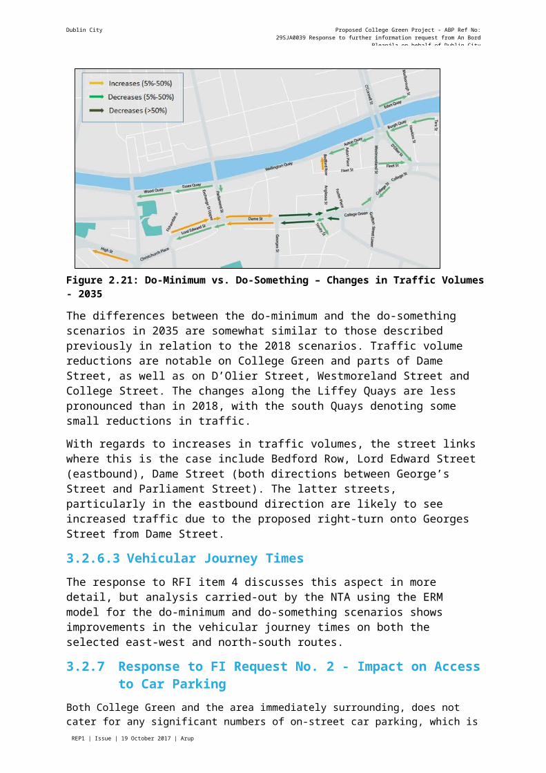
Dublin City Proposed College Green Project - ABP Ref No: 29SJA0039 Response to further information request from An Bord Pleanála on
Page REP1 | Issue | 19 October 2017 | Arup
Table 5.2: Comparison of vibration levels between trucks and buses (mm/s2) at 25km/hr
Location Bus TruckGround in front of house 20.5 19.9External foundation wall 11.2 10.1Mid-point of floor in 1st storey 20.3 20.8Mid-point of floor in 1st storey 35.0 37.3
As outlined in Table 5.2, vibration levels generated by buses and trucks are broadly similar when travelling at 25km/hr. It is noted that the speed limit in Dublin city centre zone is 30km/hr.
Predicted peak hour vehicle movements are provided in Table 5.3 for Parliament Street in the do-minimum (DM) and do-something scenarios (DS) for 2018 and 2035.
Table 5.3: Peak hour traffic volumes
Scenario Car/Taxi LGV HGV1 BusTotal
vehiclesTotal
HGV/bus
2018 DM 354 97 35 5 491 40DS 52 0 0 53 105 53
2035 DM 385 115 39 36 575 75DS 36 0 0 51 87 51
1 Although there is a HGV ban in Dublin City Centre, this covers vehicles with five axles or more. Smaller sized HGV are permitted and are represented in these projections.
As outlined in Table 5.3, the numbers of peak hour HGVs (including buses) are predicted to increase by 13 vehicles when comparing the DM scenario to the DS scenario in 2018 and predicted to decrease by 24 vehicles in 2035.
An increase of 13 HGV during peak hour is not expected to generate significant additional vibration. This is confirmed through the vibration monitoring which demonstrates current low vibration levels at building facades during the passing of buses on Parliament Street.
As outlined in the NRCC report, vibration due to traffic is generally generated by irregularities in the road surface. The road surface of Parliament is not expected to deteriorate due to the proposed traffic changes on Parliament Street. In fact, the significant reduction in vehicular traffic on Parliament Street as a result of the Proposed Project should help to maintain a regular surface.
3.5.2.5 Conclusion
Baseline vibration levels currently experienced on Parliament Street are low when compared to limit value of 7.5mm/s at which no cosmetic damage should occur. The highest vibration levels recorded coincided with the use of portable fork trucks associated with deliveries to premises on Parliament Street.
An increase of 13 HGV (including buses) during peak hour in 2018 is not expected to generate significant additional vibration. Due to the low vibration levels currently experienced on Parliament Street, the introduction of even further bus numbers is not therefore expected to result in cosmetic damage to buildings.
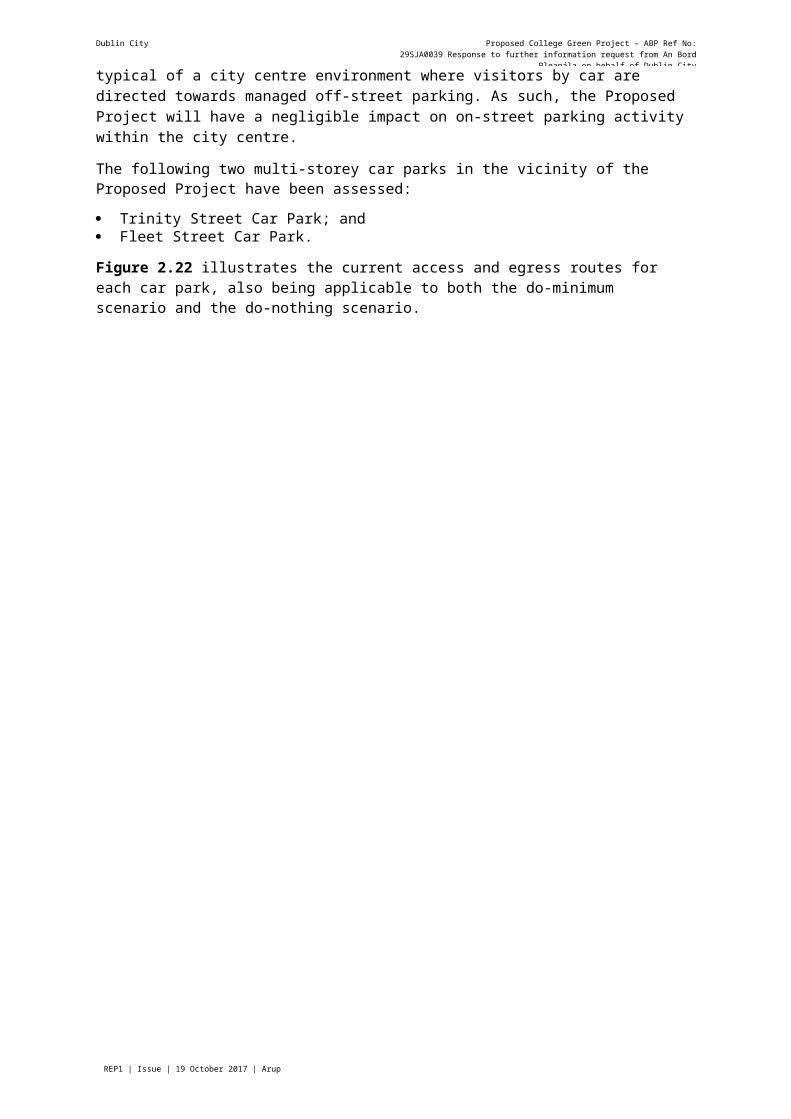
Dublin City Proposed College Green Project - ABP Ref No: 29SJA0039 Response to further information request from An Bord Pleanála on
Page REP1 | Issue | 19 October 2017 | Arup
3.6 Further Information Request No. 63.6.1 Question raised- “A map to appropriate scale indicating the streets referred to in Appendix 6.1 and
surrounding area showing the names of each street
- Cross-Sectional Drawing (Scale 1:100) through the front gate of Trinity College to the first building on the corner of Grafton St Lower/College Green. This should also indicate the route for emergency vehicles and any differences in level for crossing east to west.
- Pedestrian/ cyclist priority measures at the west end of College Green Plaza and if signalisation is proposed at this crossing point.
- The Board wishes to point out that Sections 5.9 to Sections 5.13 of Chapter 5 references in Table of Contents are not included in the EIS received by the Board.”
3.6.2 Response to Further Information Request No. 63.6.2.1 Map showing streets referred to in Appendix 6.1
A map indicating the streets referred to in Appendix 6.1 of the EIAR and surrounding area has been prepared. The map is included here as Figure 6.1 and included in Appendix 6.1 of the EIAR.
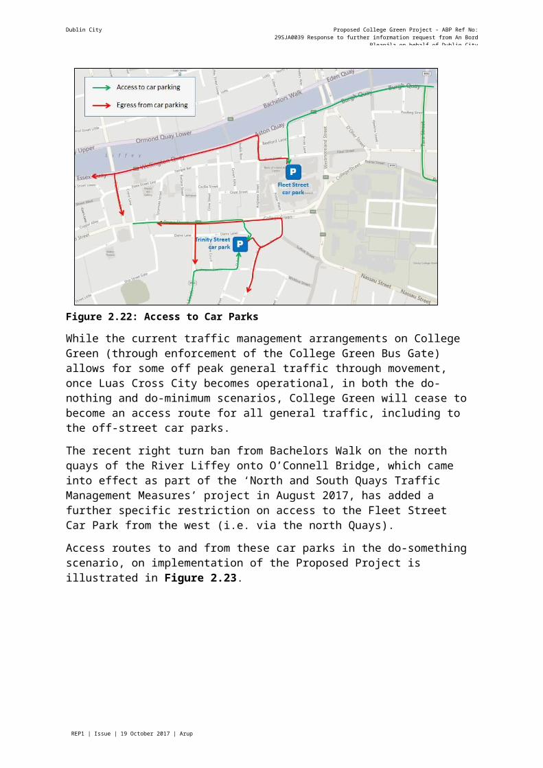
Page REP1 | Issue | 19 October 2017 | Arup
Dublin City Council Proposed College Green Project - ABP Ref No: 29SJA0039Response to further information request from An Bord Pleanála on behalf of Dublin City Council
Figure 6.1: Map showing streets referred to in Appendix 6.1
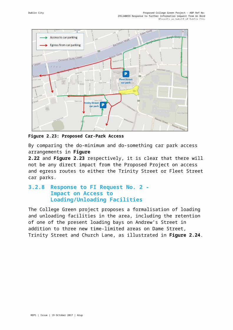
Dublin City Proposed College Green Project - ABP Ref No: 29SJA0039 Response to further information request from An Bord Pleanála on
3.6.2.2 Cross-sectional drawingA Cross-Sectional Drawing (1721/PA/122/B), of Scale 1:100 through the front gate of Trinity College to the first building on the corner of Grafton St Lower/College Green has been prepared. As requested the drawing, indicates the route for emergency vehicles and any difference in level for crossing east to west. In addition to the above requested drawing, two further Cross-Sectional Drawings (1721/PA/123/A, 1721/PA/124/A) have been provided, these sections should assist in further understanding the level changes at the south east corner of the plaza. These drawings have been included in Appendix E.
3.6.2.3 Pedestrian/ cyclist priority measures at the west end of College Green Plaza
As described in Section 4.4.3 of the May 2017 EIS, College Green terminates at the western end on the eastern side of the junction of Dame Street with Anglesea Street, which links northward into Temple Bar. This is the location where the proposed high-quality paved plaza treatment will terminate at the interface with the "normal" street layout along Dame Street.
The reference to the term ‘crossing point’ at this location is assumed to refer to the north-south pedestrian route between Anglesea Street and Trinity Street, which are separated by a stagger distance of 30m. There is an existing signal-controlled pedestrian crossing on Dame Street located between these two side streets as shown in Figure 6.2. This crossing is located at a very short distance of just 30m west of the western end of College Green.
As is shown in Figure 4.6 of the May 2017 EIS (shown below as Figure 6.3), this existing signal pedestrian crossing will be retained in the Proposed Project, and relocated slightly westward so as to better align with the eastern footpath on Trinity Street. This minor adjustment will better suit the main pedestrian desire line between Trinity Street and Temple Bar via the (former) Central Bank Plaza, a short distance to the west. Other details shown on this drawing are:
Footpath widening of up to 2.25m on Dame Street through road narrowing;
Pedestrian ‘plateau junction treatment’ at Trinity Street for the footpath on the southern side of Dame Street.
Cycle lanes (1.75m wide) along Dame Street in the east-west direction; and
A raised platform, uncontrolled pedestrian crossing at the western edge of College Green within the high-quality paving just to the east of the Anglesea Street junction.
REP1 | Issue | 19 October 2017 | Arup Page 52J:\252000\252740-00\4. INTERNAL\4-03 DESIGN\4-03-02 CONSULTING\FI\RESPONSES\RFI RESPONSE- REPORT_FINAL_ISSUE - 19 OCT '17.DOCX
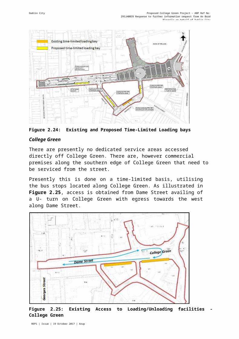
Page REP1 | Issue | 19 October 2017 | Arup
Dublin City Proposed College Green Project - ABP Ref No: 29SJA0039 Response to further information request from An Bord Pleanála on
Figure 6.2: Existing Pedestrian Signal Crossing at western end of College Green and eastern end of Dame Street between Trinity Street and Anglesea Street
Figure 6.3: Detail of Proposed Project at the Western end of College Green showing Pedestrian and Cyclist Priority Measures

Dublin City Proposed College Green Project - ABP Ref No: 29SJA0039 Response to further information request from An Bord Pleanála on
Page REP1 | Issue | 19 October 2017 | Arup
Figure 6.4: Detail from Architectural Drawing No.1721/PA/107/A by Paul Keogh Architects showing uncontrolled pedestrian crossing on a raised platform at western end of College Green (indicated by the blue line with arrows)
From the above information, it can be seen that all appropriate priority measures for pedestrians and cyclists have been included within the Proposed Project at this location. There will be two north-south pedestrian crossings of College Green and Dame Street within 30m of each other. The existing signal controlled crossing will be retained on the busiest pedestrian route at Trinity Street, and this will be complemented by an uncontrolled crossing just east of Anglesea Street, refer to Figure 6.4 for details. As described in the Design Manual for Urban Roads and Streets (DMURS) (Department of Transport, Tourism and Sport and Department of Environment, Community and Local Government, 2013), this raised platform entry treatment to College Green at the western end will function as a ‘courtesy crossing’, refer to Figure 6.5. In effect the uncontrolled crossing will operate in the shadow of the signal crossing in terms of benefitting from traffic being stopped regularly at the signals which will further assist pedestrians to cross the road at Anglesea Street at the same time.
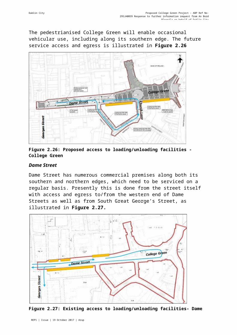
Dublin City Proposed College Green Project - ABP Ref No: 29SJA0039 Response to further information request from An Bord Pleanála on
Page REP1 | Issue | 19 October 2017 | Arup
Extract from DMURS page 89 - Courtesy Crossing
Figure 6.5: Extract from DMURS page 89 - Courtesy Crossing
The closure of College Green to all traffic, and the re-routing of most bus services and taxis away from this location will greatly reduce the traffic volumes along Dame Street to and from College Green.
In the eastbound direction, general traffic will not be permitted beyond the Anglesea Street junction and will be required to turn either right onto Trinity Street beforehand, or left onto Anglesea Street for access purposes only. Thus, only a small number of bus routes will use the turnaround arrangement at Church Lane. A very small number of service vehicles and traffic to the Bank of Ireland will also travel along this section of the street.
In the westbound direction, in addition to the few buses, there will be a very small flow of access traffic from Church Lane headed back towards Dame Street.
The traffic context will therefore be for very low vehicle flows compared to the existing situation, and a controlled pedestrian crossing of Dame Street will be hardly necessary, apart from to cater for the safety and comfort of the visually and mobility impaired pedestrians.
The retained signal crossing can operate on a frequent cycle with extended pedestrian crossing stage duration for greatest benefit for pedestrians over the small traffic flow.
Dublin City Proposed College Green Project - ABP Ref No: 29SJA0039 Response to further information request from An Bord Pleanála on
Page REP1 | Issue | 19 October 2017 | Arup
This will be similar to the existing arrangement at the southern end of Grafton Street at St. Stephen's Green where interruption for pedestrians is minimal.
3.6.2.4 Omission of Sections 5.9 to Sections 5.13
The omission of Sections 5.9-5.13 from the May 2017 EIS was a result of a printing error. The sections are now included in the EIAR, and the addition of the same has been noted in the Schedule of Amendments (refer to Appendix A).
3.7 Further Information Request No. 73.7.1 Question raised- “A response to the statement by Dublin Bus that the design of the proposal is premature
pending the outcome of the Dublin Area Bus Network redesign.”
- The recommendation made by the NTA and Dublin Bus that two-way bus movement be facilitated on Parliament Street (subject to a limit on the number of buses) as an alternative to routing buses through Winetavern Street, which is considered too far from the central area.
- The recommendation made by Dublin Bus that west to east bus movements retained through College Green and how this could potentially be accommodated in the design of the proposal in a manner that gives priority to pedestrians.
- The concern expressed by Dublin Bus that capacity issues are not referred to in modelling and that the extent of resultant queuing is not referred to.
- The concern that there is a difference between what was modelled and is proposed, with particular reference to Parliament Street.
3.7.2 Response to Further Information Request No. 73.7.2.1 Redesign of bus network is premature
A full redesign of the overall bus network and service provision for the Dublin region is being undertaken by the NTA assisted by specialist international transit system designers. This redesign is entitled Bus Connects (www.busconnects.ie). Initial design work has been carried out with further work on-going over the next few months.
This is a regional wide network redesign with the majority of changes, and the most significant changes, likely to occur outside the City Centre.
The network redesign is being undertaken on the assumption that east-west and west –east movement is not available for bus routes through College Green. Accordingly, the redesign is using bus routings on other corridors within the City Centre and only utilises College Green on its north-south / south-north axis, connecting Grafton Street Lower to Westmoreland Street / College Street.
As the redesign is proceeding on the above basis, the College Green proposal cannot be considered to be premature pending the bus network redesign.
There are two main points to note regarding Bus Connects:
It is a network review; forming a plan.
The network review acknowledges a number of issues.
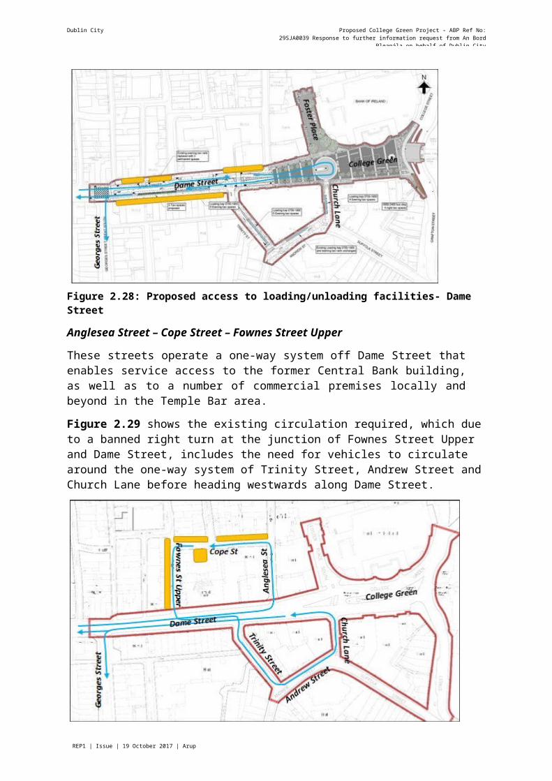
Dublin City Proposed College Green Project - ABP Ref No: 29SJA0039 Response to further information request from An Bord Pleanála on
Page REP1 | Issue | 19 October 2017 | Arup
What is Bus Connects?
Bus Connects is a plan to fundamentally transform Dublin’s bus system, so that journeys by bus will be fast, reliable, punctual, convenient and affordable. It will enable more people to travel by bus than ever before, and allow bus commuting to become a viable and attractive choice for employees, students, shoppers and visitors. Bus Connects takes cognisance of the College Green Plaza and is determining routes based on no east west, west east bus movement through College Green.
Bus Connects has come about due to the acknowledgement that the existing network has:
Many overlapping lines, each with their own frequency, prevent buses from being evenly spaced to minimize waiting. Along with low frequency on some lines, this means many people wait longer than they need to;
Complexity. The sheer number of lines and branches is a barrier to understanding the network, and discourages many trips for which service could be useful;
Too many buses in the City Centre. Many streets carry extremely high volumes of buses, which produce major delay by buses blocking each other; and
Poor Orbital Service. There is abundant service into and out of the City Centre, but poor service for travel between other destinations, especially between origins and destinations on the same side of the city.
3.7.2.2 Two-way bus movements on Parliament Street
Dublin City Council and the National Transport Authority published the Dublin City Centre Transport Study in 2016. This document highlights the desire to make Parliament Street “two- way for bus use”. As outlined in Chapter 2 of the May 2017 EIS, a number of options were considered during the design development process. Bus movements on Parliament Street were examined and modelled, from both a capacity and air quality perspective, as described in Section2.4.4 of the May 2017 EIS. The two-way bus use on Parliament Street was eventually ruled out due to the predicted exceedance of the air quality standards due to the proposed increase in number of buses. As a result, it was proposed to retain Parliament Street in its current form as southbound only and to limit the number of buses being rerouted on this street insofar as is required to adhere to the EU Air Quality Standards.
Dublin City Council, while being the Roads Authority, does not manage the bus fleet, or the licensing of the bus route network in Dublin. These are functions of the National Transport Authority. Dublin City Council is satisfied to accept two-way bus movements on Parliament Street once there is no breach of the EU air quality standards.
In its submission, the NTA has demonstrated that the introduction of Euro VI buses will have a significant beneficial impact on air quality in general. It states that the Euro VI standard reduces the limit for nitrogen dioxide (NOx) by approximately 80%, down to 0.4g/kWh. The submission models the effect of the introduction of 77 buses in the southbound direction on Parliament Street in addition to 53 buses in the northbound direction assuming the use of Euro VI buses only.Predicted values at the receptors modelled on Parliament Street are in compliance with air quality standards.
In addition, a modelling assessment is included in the submission which sensitivity tests the introduction of 106 Euro VI buses northbound and 154 buses southbound. Predicted concentrations are in compliance with air quality standards for this scenario.

Dublin City Proposed College Green Project - ABP Ref No: 29SJA0039 Response to further information request from An Bord Pleanála on
Page REP1 | Issue | 19 October 2017 | Arup
On this basis, the introduction of two-way buses on Parliament Street would not result in an exceedance of air quality standards once Euro VI buses are in use only. Therefore, Dublin City Council is satisfied that two-way bus movements can be implemented on Parliament Street in the future, however, this measure does not form part of the College Green Project.
The future potential diversion of northbound buses to Winetavern Street, buses will be subsequently routed via the north Quays, availing of high capacity and relatively short walk times from most city centre destinations. Refer to Section 3.2.5 for further information.
3.7.2.3 West to east bus movements to be retained through College Green
As outlined in Section 2.4.3 of the May 2017 EIS, Clifton Scannell Emerson Associates (CSEA) was commissioned by DCC to assess a number of public realm strategy options for College Green, refer to Appendix F. CSEA reported on 12 different alternatives regarding traffic movements at Dame Street and College Green. It was determined that a full plaza was optimum from a public realm, pedestrian, cyclist, safety and Luas perspective.
It is not possible to maintain pedestrian priority in a shared space with buses, this area would need to be controlled by traffic signals, and have a raised kerb in order to delineate it. These measures would be contrary to the philosophy and intent of the space.
The commencement of Bus Connects is very timely and not only will it seek to address the overlapping lines, complexity of the number of lines, overcrowding of buses in the city centre and poor orbital service but it will give further opportunity to reroute any line affected by the Proposed Project.
Bus Connects is being planned with the understanding of a plaza at College Green.
3.7.2.4 Modelling of capacity issues
The NTA road model assigns passenger cars to the road network and includes representation of capacity constraint, traffic signal delay and the impact of congestion. The road network has been modelled in Saturn.
The public transport (PT) model assigns person trips to the PT network and includes the impact of capacity constraint, such as crowding on PT vehicles, on people’s perceived cost of travel. The model includes PT networks and services for all PT sub-modes that operate within the modelled area. The full NTA traffic modelling report on the proposed traffic management measures addresses both capacity and queuing issues, and is included in Appendix B.
3.7.2.5 Difference in what was modelled compared to what is proposed
It is confirmed that there is no difference in what was modelled and what is proposed. The NTA modelling report has been included in Appendix B and as Appendix 6.1 of the EIAR.
3.8 Further Information Request No. 83.8.1 Question raised“The lack of segregated cycle facilities throughout the scheme and the potential for conflict with pedestrians, other vehicular traffic, including Luas Cross City, buses, taxis and cars has been raised in various submissions to the Board, including Dublin Bus, TII, Dublin Chamber, IrishCycle, and the NTA. Dublin City Council is requested to address this matter and indicate how these conflicts would be managed or what reasonable alternatives were considered.
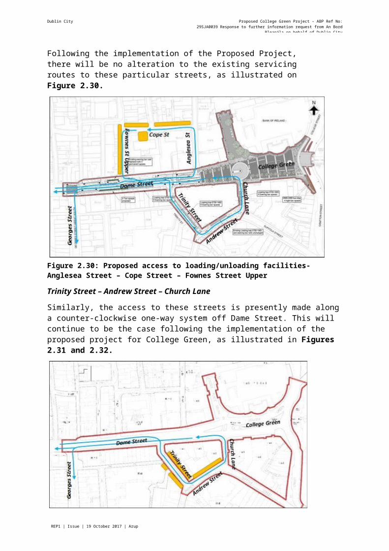
Dublin City Proposed College Green Project - ABP Ref No: 29SJA0039 Response to further information request from An Bord Pleanála on
Page REP1 | Issue | 19 October 2017 | Arup
Concerns regarding potential conflict arise in particular along a north-south axis, on the turning circle, at the access to the Bank of Ireland, and to the south east end of the plaza at the crossover to Grafton St. Lower.”
3.8.2 Response to Further Information Request No. 83.8.2.1 Provisions for Cyclists in the Scheme
Careful consideration was given to select the most appropriate provisions for cyclists within the scheme on the basis of various functionality requirements and the relevant conditions in terms of the mix and volumes of different user groups. The scheme provides for a clear and legible route for cyclists through the plaza area through allocation of physical space that best suits the overall street layout in each zone.
The May 2017 EIS describes the process by which the proposed arrangements were selected in the following sections:
Alternatives considered
2.4.3 Public Realm Strategy Alternatives: 12 no. options considered; and
2.4.5 Architectural Design Alternatives:
o overall spatial layout versions considered; and
o 8 alternative cycle movement options.
The provisions for cyclists within the scheme need to be understood in the context of the overall philosophy of the spatial arrangements at College Green. This highly important public space is intended primarily to function as a pedestrian plaza, and to cater for select movement functions as a complementary matter in an arrangement that does not compromise the overall comfort and security of pedestrians. In Section 4.4.3 of the May 2017 EIS the intent of the design is described as a "Pedestrian-priority plaza".
One of the options considered for cycling through College Green is described as follows:
"...cycle track across the eastern side of the plaza adjacent to the LUAS line. Cyclists would then weave through gaps in the heavy north-south pedestrian flow to continue across the 'pedestrian- priority' area." (Page 2-10).
This arrangement was not selected as it was considered insufficient to achieve the objectives of the GDA Cycle Network Plan (National Transport Authority, 2013).
Instead it was decided that the scheme should include a two-way cycle route around the southern edge of the plaza and delineated with a line of trees, which is shown in Figure 4.10 in the May 2017 EIS, replicated in Figure 8.1 in this report. In technical terms this is not a ‘cycle track’ for the exclusive use of cyclists, as that would introduce a cumbersome and unwieldy requirement for formalised pedestrian crossings at numerous locations to suit the various desire lines for pedestrian movements. Instead it is a defined part of the pedestrian plaza that cyclists are directed towards and away from the central zone which will accommodate pedestrians to linger and possibly sit in to enjoy the setting amongst some of the finest historical buildings in Dublin city centre.

Dublin City Proposed College Green Project - ABP Ref No: 29SJA0039 Response to further information request from An Bord Pleanála on
Page REP1 | Issue | 19 October 2017 | Arup
Figure 8.1: Extract from Figure 4.10 of the May 2017 EIS - Cycle Route shown in green arrows
3.8.2.2 Pedestrian Priority Area and Cyclists
The Dublin City Development Plan 2016 to 2022 (Dublin City Council, 2016) includes (on page67) a specific objective for College Green as follows:
College Green will mainly function as a pedestrian only zone with physical arrangements to channel cyclists and a small volume of access traffic away from the main pedestrian-priority areas of the plaza in the central zone.
The 3.5m wide cycle route across the plaza will be separated from the adjoining footpath to the south by a delineation paving strip. On the northern side the cycle route will be separated from the pedestrian zone of the plaza by a row of trees and various items of street furniture. The start of the cycle route will be indicated by signs RUS 058CL for the eastbound direction and sign RUS 058CR for the westbound direction as shown following.
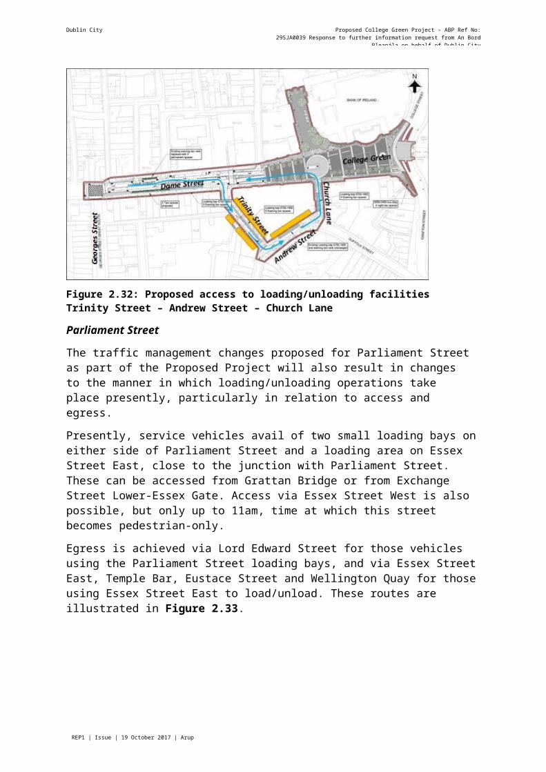
Dublin City Proposed College Green Project - ABP Ref No: 29SJA0039 Response to further information request from An Bord Pleanála on
Page REP1 | Issue | 19 October 2017 | Arup
In spatial terms the total area of the plaza is 3,600m2 approximately (excluding Foster Place), of which only about 8% will consist of the cycle route. Thus the design accommodates the cycle route with minimal intrusion into the pedestrian space.
The two crossing points for the main north-south pedestrian route at the southeast corner of the plaza at Lower Grafton Street, and also near the corner of Church Lane, will be governed under Sign RUS 058 of the Traffic Regulations that will denote the space for pedestrian priority as indicated in the extract below from Traffic Signs Manual Chapter 5:
The provision above advises that the shared arrangement for pedestrians and cyclists should "only be used in exceptional circumstances where it is impracticable to provide segregated facilities...". College Green clearly is an exceptional circumstance where the free movement of pedestrians across the plaza area is a key objective to achieve a high-quality environment, compared to the current situation that severely inhibits pedestrians and detracts from the enjoyment of the historic setting.
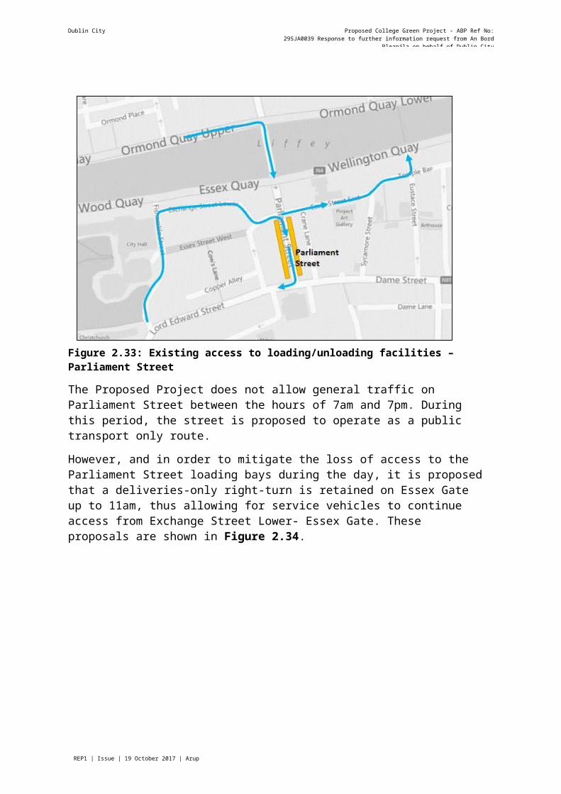
Dublin City Proposed College Green Project - ABP Ref No: 29SJA0039 Response to further information request from An Bord Pleanála on
Page REP1 | Issue | 19 October 2017 | Arup
3.8.2.3 =Visually Impaired Pedestrians
The plaza design follows best international practice for the management of the needs of the various street users in a hierarchical order that places pedestrians first, especially the visually and mobility impaired who will have full freedom of movement on two routes at the eastern and western edges of the plaza without need to worry about conflicts with cyclists and traffic at these crossing points.
Figure 8.2 shows how the proposed plaza will function for various users as illustrated by a colour-coded system as follows:
o Green: Pedestrian only zone in most of the plaza area, with very occasional vehicular access to the Bank of Ireland that will operate just like any crossing of a footpath for access to a private property. The edges of this zone are delineated by continuous corduroy tactile paving in lieu of a kerb.
o Blue: Cycle route along the southern edge of the plaza.
o Pink: Limited vehicular traffic area at western end of the plaza and on Church Lane that will function like any public road.
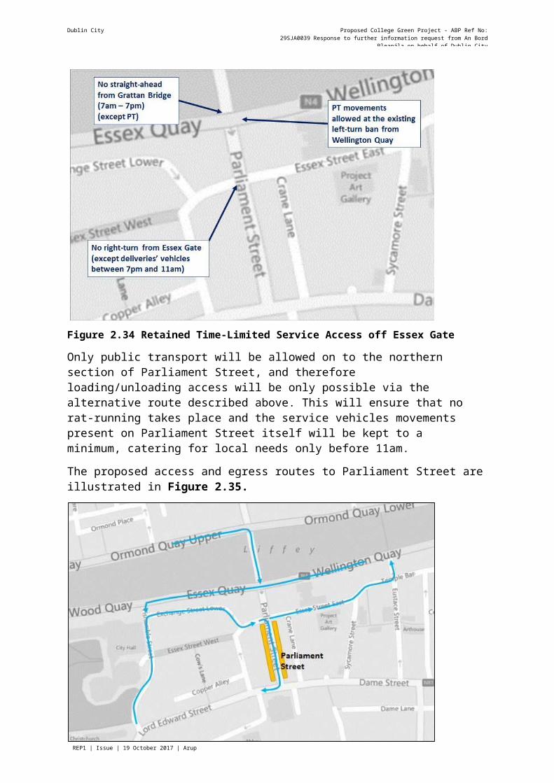
Page REP1 | Issue | 19 October 2017 | Arup
Dublin City Council Proposed College Green Project - ABP Ref No: 29SJA0039Response to further information request from An Bord Pleanála on behalf of Dublin City Council
Figure 8.2: Functional Diagram of Proposed Plaza showing various arrangements of priority

Dublin City Proposed College Green Project - ABP Ref No: 29SJA0039 Response to further information request from An Bord Pleanála on
Page REP1 | Issue | 19 October 2017 | Arup
There will be only a few formally defined pedestrian road crossings as shown on the above diagram:
a) Signal controlled crossings at Trinity College;
b) Two uncontrolled pedestrian crossings at Church Lane and the western end of College Green. These will function as courtesy crossings but are no different to all uncontrolled crossings in regulatory terms where pedestrians will be crossing the "road" and will only gain priority once they have stepped onto the road surface with care. Buff dimple tactile paving to be provided.
With these arrangements the requirements of the visually impaired pedestrian are fully catered for in compliance with all relevant regulations and best practice.
Dublin City Council will undertake further consultations during the detailed design stage with various disability group representatives including the National Council for the Blind of Ireland (NCBI) through the Public Participation Network, using existing communication arrangements to ensure that the interests of the visually impaired and other vulnerable road users are best provided for in the scheme.
3.8.2.4 Priority at Crossing Points
It is a matter of numbers that should determine the allocation of priority where pedestrians and cyclists interact within the College Green Plaza. The May 2017 EIS notes that there are currently 75,000 pedestrian movements and 6,500 cyclist movements per day across College Green. Thus with a ratio of over 10 to 1 it is most appropriate to allocate priority to pedestrians, and to require cyclists to filter through the space slowly. This is also a safe arrangement by default.
3.8.2.5 Convenience for Cyclists
It is acknowledged that the proposed cycle route across College Green is indirect, especially in the west to east direction. There are also some sharp turns that will require cyclists to travel very slowly. This is deliberate for safety reasons, so that the various interactions between cyclists and pedestrians will occur at slow speed, with cyclists required to give priority to pedestrians as they filter through the plaza.
Unlike other modes of traffic that will be displaced away from College Green, cyclists will benefit from being able to cross through the plaza the shortest and most direct route through this part of the city centre. This will provide considerable convenience as well as a greatly enhanced quality of service on streets that will have much reduced traffic volumes for better safety and comfort of cyclists.
The pedestrian priority zone of the College Green Plaza is only 60m long from west to east. Even though cyclists will be required to travel slowly at about 10 km/h or less through this space, it will take only half a minute of journey time to get through from one side to the other. Compared to the current frequent delays at multiple traffic signals between George's Street and Westmoreland Street, the journey time for cyclists should actually reduce considerably.
On balance therefore, the proposed arrangement with pedestrian priority and an indirect cycle route across the plaza will still provide considerable convenience for cyclists, but in a safe arrangement that respects the appropriate allocation of priority to pedestrians.
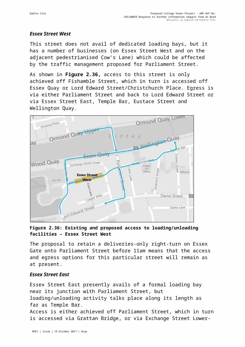
Dublin City Proposed College Green Project - ABP Ref No: 29SJA0039 Response to further information request from An Bord Pleanála on
Page REP1 | Issue | 19 October 2017 | Arup
A formally designated cycle track with signal-controlled crossings would be less favourable as it would actually increase delay and reduce convenience for both cyclists and pedestrians, as well as being inherently less safe if a pedestrian were to stray onto the cycle track unexpectedly where cyclists would be travelling at higher speed.
3.8.2.6 Delineation of the Cycle Route
There are various options for the subtle delineation of the cycle route across the plaza as described below and illustrated in the following photographs of examples in a range of European cities.
a) Differential paving materials (Figures 8.3, 8.6, 8.7),
b) A dished channel;
c) Street furniture and trees; and
d) Corduroy tactile paving (Figures 8.4, 8.5).
Figure 8.3: City Centre Street, Nantes, France: Delineation by different materials
Dublin City Proposed College Green Project - ABP Ref No: 29SJA0039 Response to further information request from An Bord Pleanála on
Page REP1 | Issue | 19 October 2017 | Arup
Figure 8.4: Corduroy Paving on Exhibition Road, London.
Figure 8.5: Stockholm with cobbled drainage channel that provides tactile delineation
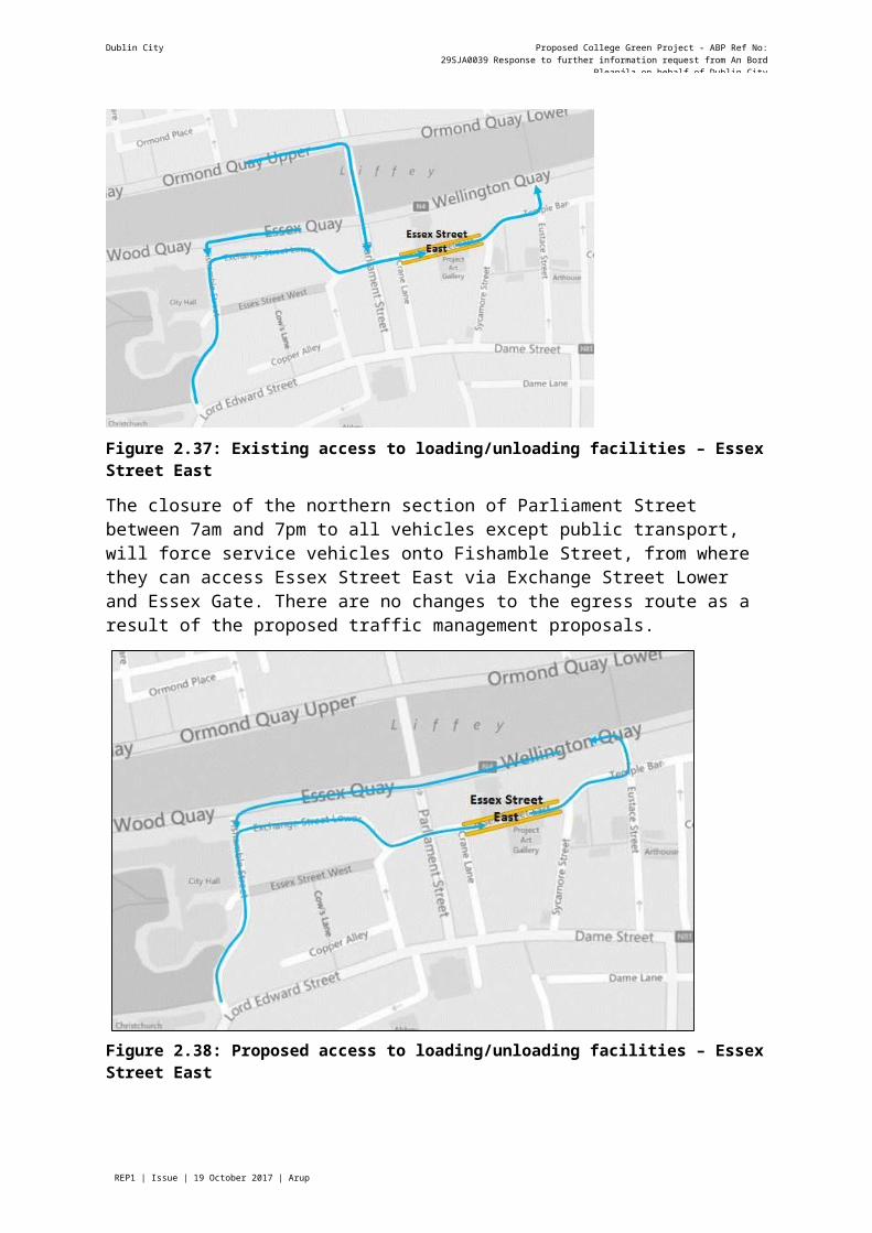
Dublin City Proposed College Green Project - ABP Ref No: 29SJA0039 Response to further information request from An Bord Pleanála on
Page REP1 | Issue | 19 October 2017 | Arup
Figure 8.6: Linz, Austria with delineation by surface materials
Figure 8.7: Cobble Surface at uncontrolled Cycleway Crossing of Pedestrian Area, Copenhagen
Dublin City Proposed College Green Project - ABP Ref No: 29SJA0039 Response to further information request from An Bord Pleanála on
Page REP1 | Issue | 19 October 2017 | Arup
The proposed scheme at College Green is consistent with the best international practice for the incorporation of cycle routes within pedestrian-priority zones in city centres. Thus cyclists will be accommodated appropriately but without formal segregation in an arrangement that provides for pedestrian priority and safety.
3.8.2.7 Potential Conflict PointsConflicts at the Turning Circle
The proposed turning circle at the junction of College Green with Church Lane provides a suitable termination for the limited traffic zone on the western side of the plaza. Approaching from the west, eastbound cyclists will travel along the delineated cycle route behind the line of trees, while buses and occasional access vehicles will travel along the centre of the street. At the proposed roundabout cyclists will use the outer annulus of the roundabout as delineated by different paving materials. An example from Denmark of such an arrangement is shown in Figure 8.8.
Buses, and other occasional vehicles permitted for access purposes, will travel around the inner part of the roundabout. Since almost all of these vehicles will be making a u-turn, there will be minimal crossing of the cycle route. During the design stage the swept path requirements for large vehicles were determined to ensure that the area for turning of buses was sufficiently large to prevent over-run onto the cycle route. This was then tested in practice using the largest tri-axle Dublin Bus vehicle in Broadstone Bus Deport, and Dublin Fire brigade training centre at Marino to confirm the design provisions.
For westbound cyclists leaving the pedestrian-priority zone of the College Green Plaza, they will be entering a public road at the roundabout and will be required to yield if necessary in accordance with the normal rule of the road. The provision of a roundabout at this transition point will provide a clear and orderly arrangement for cyclists moving onto the road and meeting conflicting traffic including u-turning buses. The very small flow of traffic from Church Lane will yield to westbound cyclists as it joins College Green and turns left.
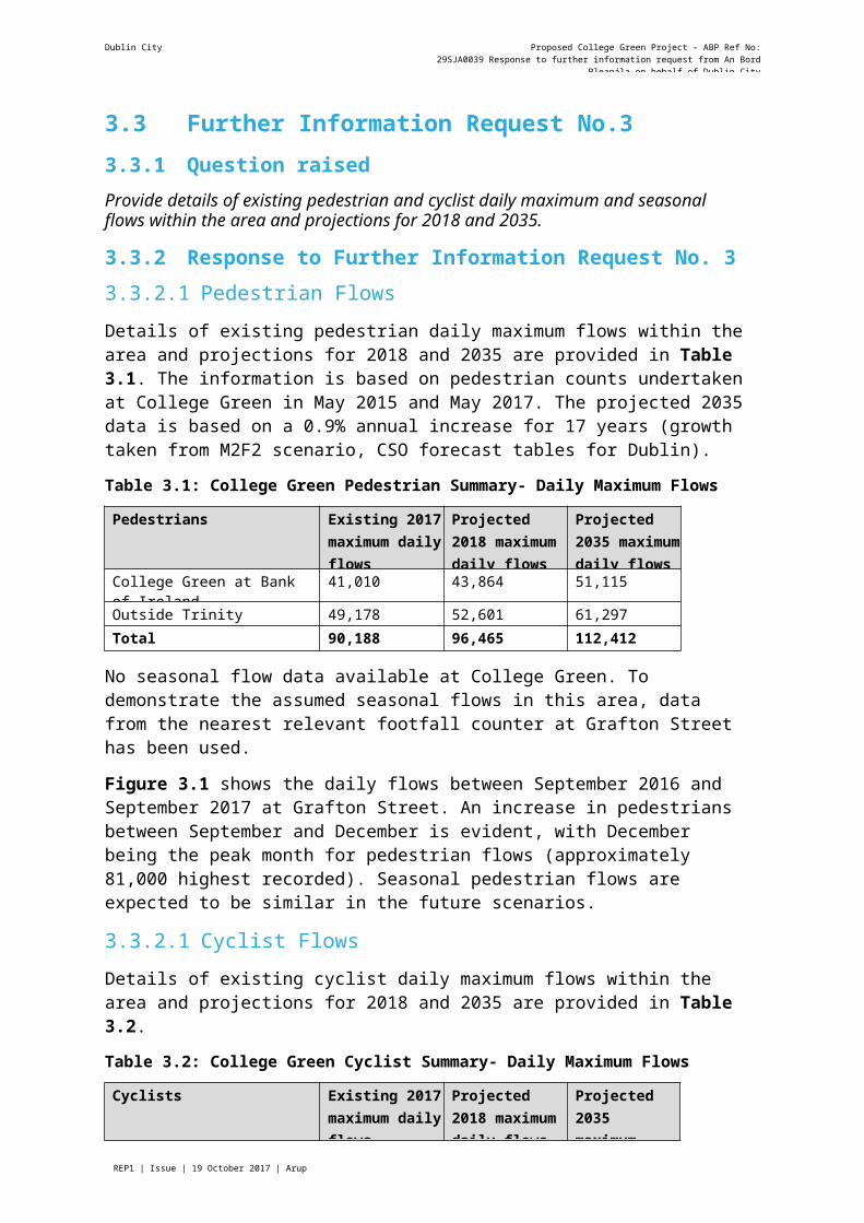
Dublin City Proposed College Green Project - ABP Ref No: 29SJA0039 Response to further information request from An Bord Pleanála on
Page REP1 | Issue | 19 October 2017 | Arup
Figure 8.8: Roundabout in Denmark with Cycle Route separated by Paving Materials
Conflicts at Bank of Ireland Access and Foster Place
Limited traffic access will be accommodated to the Bank of Ireland in the old Parliament Building on the northern side of College Green via two routes:
Cash-in-transit vehicles will require access to the bank at the rear via Foster Place. These vehicles will turn left from the roundabout and cross the cycle route around the outer edge of the roundabout;
There is a small car park on the forecourt area at the front of the bank that is used by occasional customers and is also used for deliveries. This is currently not available due to ongoing construction work. Access to the forecourt of the bank is shown in Figure 4.10 of the May 2017 EIS and is channelled along the northern edge of the pedestrian-priority area of the plaza with delineation by street furniture.
Access traffic to the bank via both routes will need to turn left off the roundabout where the normal rules of the road will apply for the interaction with cyclists as for any left-turn movement in a junction. Likewise, the access routes will require traffic to cross the footpath along the northern edge of the plaza, where pedestrians will have priority as for access to any premises from a public road.
Conflicts at Southeast end of Plaza / Grafton Street Lower
In terms of the numbers of pedestrians and cyclists involved, this will be the busiest interaction point within the plaza. It will however be much less busy than was the situation previously when there was also a large volume of vehicular traffic involved in the mix and pedestrians were required to wait for a traffic signal to cross the road in two stages, which gave rise to bunching, congested footpaths and jay-walking.

Dublin City Proposed College Green Project - ABP Ref No: 29SJA0039 Response to further information request from An Bord Pleanála on
Page REP1 | Issue | 19 October 2017 | Arup
No matter what arrangement is provided at this location, there will need to be give and take between north-south movements and east-west movements. The Proposed Project will require pedestrians and cyclists to filter through this uncontrolled crossing with courtesy and consideration for each other. This is a benignly safe arrangement compared to the alternative of a controlled crossing with alternating priority that is likely to be ignored by many people anyway. The geometric layout provides speed control for cyclists who will invariably have to give way to the much larger number of pedestrians at slight inconvenience.
3.8.2.8 Provisions for Cyclists on Dame Street
The speed limit on Dame Street is 30 km/h as part of the City Centre zone, which provides a suitable and safe environment for cyclists on the street.
In accordance with the National Cycle Manual (National Transport Authority, 2011) (Section1.7.4 Guidance Graph, shown on Figure 8.9) on a street with a 30 km/h speed limit it is appropriate for shared use of the street without cycling facilities in the context of traffic flows of up to 10,000 AADT vehicles per day. Traffic flows on Dame Street are already far below this level, and will reduce further once the College Green Plaza is in place and most bus services and taxis are re-routed. Thus cycle lanes are not necessary in accordance with the relevant design standard.
Nevertheless, the Proposed Project includes provision of cycle lanes on Dame Street for guidance of cyclists to indicate that Primary Cycle Route 7 follows this street from the western part of the city through College Green, merging with Route 11 from Trinity Street / Church Lane, towards O'Connell Bridge.
Figure 8.9: National Cycle Manual: Guidance for Cycling Facilities in accordance with Volume and Speed of General Traffic
There is no necessity for the provision of a segregated cycle facility along Dame Street in the context of the low traffic speed and very low traffic flows. The provision of cycle lanes within the proposed College Green Project is therefore more than sufficient.

Dublin City Proposed College Green Project - ABP Ref No: 29SJA0039 Response to further information request from An Bord Pleanála on
Page REP1 | Issue | 19 October 2017 | Arup
3.9 Further Information Request No. 93.9.1 Question raisedConcerns have been raised in the submissions received regarding the impacts of the proposal in combination with other transport measures on accessibility to the city centre and the consequences for the economic performance and competitiveness of the city centre. To address this matter it is requested that a comprehensive socio-economic assessment of the impact of the proposed development be undertaken (in conjunction with other proposed traffic management measures) on the city centre retail environment, business and tourism interests arising from potential reduced access to the city centre by private vehicles, taxis, etc. and the diversion of bus routes, relocation of bus stops, displacement of bus customers during both the construction/operational stages, severances of routes, increased journey times and costs.
Any response to 7 to 9 above should, where relevant, be incorporated into the EIAR. In preparing its response Dublin City Council is also requested to have due regard to the other issues raised in the submissions made to the Board.
3.9.2 Response to Further Information Request No. 9A socio-economics impact assessment of the Proposed Project in conjunction with other proposed traffic management measures has been carried out by Future Analytics Consulting Ltd.
The assessment addresses the impact of the Proposed Project on the city centre retail environment, business and tourism interests arising from potential reduced access to the city centre by private vehicles, taxis, etc. and the diversion of bus routes, relocation of bus stops, displacement of bus customers during both the construction/operational stages, severances of routes, increased journey times and costs.
The Socio-Economics Assessment Report is included in Appendix G.
Top Related