


Languages
Pages
Legal


Quigley Canyon Ranch Water Rights Valuation
Quigley Canyon Ranch Water Rights Valuation
FINAL REPORT
City of Hailey
115 S. Main St. #H Hailey, ID 83333
WestWater Research
805 W. Idaho St., Suite 310
Boise, ID 83702
February 10, 2012
Confidential and Privileged Information
P a g e | 2
Table of Contents
Background 3
Water Rights Description 4
Water Right History .......................................................................................................................... 9
Water Rights Assessment 12
Transferability ................................................................................................................................ 12
Stacked Water Rights ............................................................................................................... 12
Rohe Decision .......................................................................................................................... 13
Conjunctive Management Mitigation ........................................................................................ 14
Transferability Summary .......................................................................................................... 14
Reliability and Seniority ................................................................................................................. 15
Water Availability .................................................................................................................... 15
Estimated Transferable Quantity ............................................................................................... 17
Alternative Water Supplies ............................................................................................................. 18
Surface Water ........................................................................................................................... 18
Groundwater ............................................................................................................................. 18
Water Supply and Demand Assessment .................................................................................... 19
Regional Water Supply ............................................................................................................. 19
Regional Water Demand ........................................................................................................... 20
Urban Water Demand ............................................................................................................... 21
Agricultural Water Demand ...................................................................................................... 22
Mitigation Demand ................................................................................................................... 23
Current Economic Conditions ................................................................................................... 25
Supply and Demand Summary .................................................................................................. 26
Water Rights Valuation 27
Highest and Best Use ...................................................................................................................... 27
Valuation Methodology .................................................................................................................. 27
Sales Comparison Approach ........................................................................................................... 28
Water Right Sales ..................................................................................................................... 28
Other Reported Market Activity ................................................................................................ 32
Price Adjustments ..................................................................................................................... 33
Water Right Comparable Sales Summary.................................................................................. 35
Land Price Differential Approach .................................................................................................... 35
Summary and Value Conclusions 37
Appendix A: Water Right File 39
Appendix B: Maps 40
Confidential and Privileged Information
P a g e | 3
Background
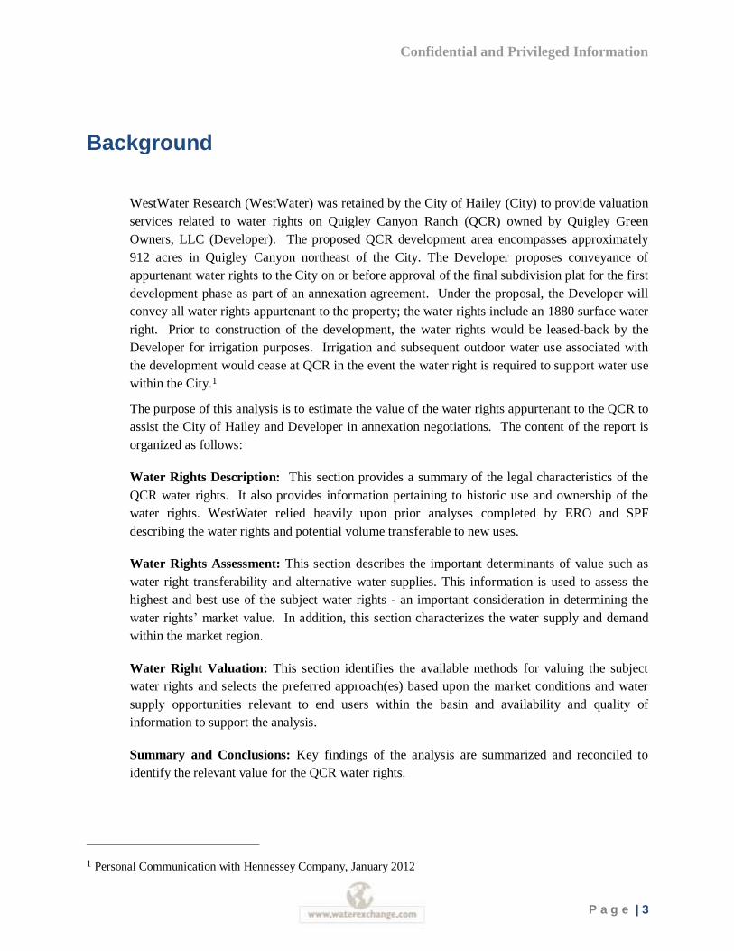
WestWater Research (WestWater) was retained by the City of Hailey (City) to provide valuation
services related to water rights on Quigley Canyon Ranch (QCR) owned by Quigley Green
Owners, LLC (Developer). The proposed QCR development area encompasses approximately
912 acres in Quigley Canyon northeast of the City. The Developer proposes conveyance of
appurtenant water rights to the City on or before approval of the final subdivision plat for the first
development phase as part of an annexation agreement. Under the proposal, the Developer will
convey all water rights appurtenant to the property; the water rights include an 1880 surface water
right. Prior to construction of the development, the water rights would be leased-back by the
Developer for irrigation purposes. Irrigation and subsequent outdoor water use associated with
the development would cease at QCR in the event the water right is required to support water use
within the City.1
The purpose of this analysis is to estimate the value of the water rights appurtenant to the QCR to
assist the City of Hailey and Developer in annexation negotiations. The content of the report is
organized as follows:
Water Rights Description: This section provides a summary of the legal characteristics of the
QCR water rights. It also provides information pertaining to historic use and ownership of the
water rights. WestWater relied heavily upon prior analyses completed by ERO and SPF
describing the water rights and potential volume transferable to new uses.
Water Rights Assessment: This section describes the important determinants of value such as
water right transferability and alternative water supplies. This information is used to assess the
highest and best use of the subject water rights - an important consideration in determining the
water rights’ market value. In addition, this section characterizes the water supply and demand
within the market region.
Water Right Valuation: This section identifies the available methods for valuing the subject
water rights and selects the preferred approach(es) based upon the market conditions and water
supply opportunities relevant to end users within the basin and availability and quality of
information to support the analysis.
Summary and Conclusions: Key findings of the analysis are summarized and reconciled to
identify the relevant value for the QCR water rights.
1 Personal Communication with Hennessey Company, January 2012
Confidential and Privileged Information
P a g e | 4
Water Rights Description
This analysis considers the value of the water rights appurtenant to the QCR property. Of
particular importance is the 1880 priority date water right located on the property. Due to the
overlapping (“stacked”) nature of the water rights on the QCR property, this analysis describes all
of the QCR water rights. The water rights appurtenant to the QCR property include four surface
water rights (37-2784A, 37-7693, 37-8283, and 37-19736) and three groundwater rights (37-
20902, 37-21348, and 37-21349). The surface water rights authorize a combined diversion of
5.53 cfs (2,500 gpm) from Quigley Creek for irrigation of 276.5 acres. The groundwater rights
authorize a withdrawal of 2.01 cfs (900 gpm) from a groundwater well for irrigation of 123.4
acres. However, the water rights are restricted to a combined total of 276.5 acres that can be
irrigated annually from both the ground and the surface water sources. Table 1 provides a
summary of the water rights associated with the QCR. Copies of the relevant water right files are
located in Appendix A.
Table 1: Summary of QCR Water Rights
Water Right
Source Tributary
to Priority
Date Rate (cfs)
Volume (AFY) Irrigated Area
37-2784A Quigley Creek Sinks 1967
16 154
37-7693 Quigley Creek Sinks 1977 5.27 30 (storage)
900 (Irrigation) 276.5
37-8283 Quigley Creek Big Wood
River 1986 0.12
35 (storage) 6.7 (stockwater)
37-19736 Quigley Creek Sinks 1880 2.28
276.5
37-20902 GW
1966 2.01 340.2 113.4
37-21348 GW
1985
35 10
37-21349 GW
1969
56.7
* 37-2784A, 37-7693 and 37-19736 are limited to a combined diversion rate of 5.53 cfs
*37-2784A and 37-7693 are limited to a total annual storage volume of 30 AF
*37-2784A, 37-7693, 37-19736, 37-20902, 37-37-21348 and 37-21349 are limited to a total annual diversion volume of 967.7 AF at the field head gate
*37-2784A, 37-7693, 37-19736, 37-20902, 37-37-21348 and 37-21349 are limited to the irrigation of a combined total of 276.5 acres in a single irrigation season
*37-20902, 37-37-21348 and 37-21349 are limited to the irrigation of a combined total of 123.4 acres in a single irrigation season
*37-20902, 37-37-21348 and 37-21349 are limited to a combined diversion rate of 2.01 cfs
*37-20902 and 37-21349 are limited to the irrigation of a combined total of 113.4 acres in a single irrigation season
Figure 1 identifies the general location of the subject property owned by Quigley Green Owners,
LLC, which is directly east of Hailey in Blaine County, Idaho. The property lies along Quigley
Drive and is located immediately north of Wood River High School.
Confidential and Privileged Information
P a g e | 5
Figure 1: General Location of the Quigley Creek Ranch
On June 10, 2011, the District Court of the Fifth Judicial District of Idaho issued a Special
Master’s Recommendation for Partial Decree for six of the seven water rights on the QCR. A
summary of the individual water rights and details of their administrative histories is provided
below in Tables 2 through 8. Selected portions of each water right file are included in Appendix
A.
Confidential and Privileged Information
P a g e | 6
Table 2: Summary for Water Right 37-19736
Water Right Number: 37-19736
Owner Name: Quigley Green Owner LLC
Source: Quigley Creek, Tributary to Sinks
Uses: Irrigation
Periods of use: April 15th – October 31
st
Rate (Qi): 2.28 CFS
Priority Date: April 15th, 1880
Points of Diversion (POD): T02N R18E Section 2 and 10 within Blaine County
Place of Use (POU): 276.5 Acres within T02N R18E Section 02, 10, and 11
Additional Information:
This right is for the entire flow of Quigley Creek, originally determined to be 2.28 cfs. Rights 37-2784A, 37-7693, and 37-19736, when combined, shall not exceed a total diversion rate of 5.53 cfs, and a total annual maximum diversion volume of 967.7 AF at the field head gate. All six adjudicated rights cannot exceed 967.7 AF to irrigate a maximum of 276.5 acres in a single irrigation season.
Table 3: Summary for Water Right 37-2784A
Water Right Number: 37-2784A
Owner Name: Quigley Green Owner LLC
Source: Quigley Creek, Tributary to Sinks
Uses: Irrigation Storage
Periods of use: April 1st – November 1
st
Duty (Qa): 16 AF
Priority Date: January 3rd, 1967
Points of Diversion (POD): T02N R18E Section 10 SESWNE within Blaine County
Place of Use (POU): 276.5 Acres within T02N R18E Section 02, 10, and 11
Additional Information:
Rights 37-2784A and 37-7693, when combined, shall not exceed a total annual maximum storage volume of 30 AF. This right is limited to the irrigation of 154 acres within the place of use described in a single irrigation season. All six adjudicated rights cannot exceed 967.7 AF to irrigate a maximum of 276.5 acres in a single irrigation season.
Table 4: Summary for Water Right 37-8283
Water Right Number: 37-8283
Owner Name: Quigley Green Owner LLC
Source: Quigley Creek Tributary: Big Wood River
Uses: Storage and Stockwater
Periods of use: Year-round
Duty (Qa): Storage: 35 AF and Stockwater: 6.7 AF
Rate (Qi): 0.12 CFS
Priority Date: September 23rd, 1986
Points of Diversion (POD): T02N R18E Section 2 and 10 within Blaine County
Place of Use (POU): T02N R18E Section 01, 02, and 10
Confidential and Privileged Information
P a g e | 7
Table 5: Summary for Water Right 37-7693
Water Right Number: 37-7693
Owner Name: Quigley Green Owner LLC
Source: Quigley Creek, Tributary to Sinks
Uses: Irrigation and Irrigation Storage
Periods of use: Irrigation: April 1st – November 1
st
Irrigation Storage: March 1st – September 30
th
Duty (Qa): Irrigation: 900 AF and Storage: 30 AF
Rate (Qi) 5.27 CFS
Priority Date: December 16th, 1977
Points of Diversion (POD): T02N R18E Section 2 and 10 within Blaine County
Place of Use (POU): 276.5 Acres within T02N R18E Section 02, 10, and 11
Additional Information:
This right when combined with all other rights shall provide no more than .02 cfs per acre and 3.5 AF per acre for irrigation of the place of use.
Table 6: Summary for Water Right 37-20902
Water Right Number: 37-20902
Owner Name: Quigley Green Owner LLC
Source: Groundwater
Uses: Irrigation and Stockwater
Periods of use: Irrigation: June 1st – October 1
st and Stockwater: annual
Duty (Qa): 340.2 AF
Rate (Qi): 2.01 CFS (Irrigation) and 0.12 CFS (Stockwater)
Priority Date: July 21st, 1966
Points of Diversion (POD): T02N R18E Section 10 NWNWSE within Blaine County
Place of Use (POU): Irrigation: 123 acres within T02N R18E Section 10 and 11 Stockwater: 123 acres within T02N R18E Section 10 and 11
Additional Information:
The quantity of water under this right for stockwater use shall not exceed 13,000 gallons per day. The use of water before June 1 and after October 1 under this remark is subordinate to all water rights having no subordinated early or late irrigation use and a priority date earlier than the date a partial decree is entered for this right. This right is limited to the irrigation of 113.4 acres within the place of use described above. Rights 37-20902, 37-21348, and 37-21349 are limited to the irrigation of a combined total of 123.4 acres in a single irrigation season. All six adjudicated rights cannot exceed 967.7 AF at the field head gate in order to irrigate a maximum of 276.5 acres in a single irrigation season.
Confidential and Privileged Information
P a g e | 8
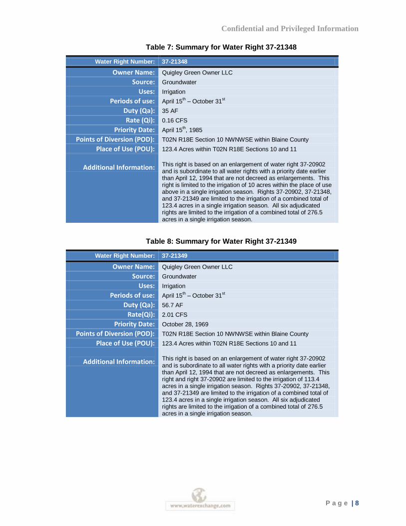
Table 7: Summary for Water Right 37-21348
Water Right Number: 37-21348
Owner Name: Quigley Green Owner LLC
Source: Groundwater
Uses: Irrigation
Periods of use: April 15th – October 31
st
Duty (Qa): 35 AF
Rate (Qi): 0.16 CFS
Priority Date: April 15th, 1985
Points of Diversion (POD): T02N R18E Section 10 NWNWSE within Blaine County
Place of Use (POU): 123.4 Acres within T02N R18E Sections 10 and 11
Additional Information:
This right is based on an enlargement of water right 37-20902 and is subordinate to all water rights with a priority date earlier than April 12, 1994 that are not decreed as enlargements. This right is limited to the irrigation of 10 acres within the place of use above in a single irrigation season. Rights 37-20902, 37-21348, and 37-21349 are limited to the irrigation of a combined total of 123.4 acres in a single irrigation season. All six adjudicated rights are limited to the irrigation of a combined total of 276.5 acres in a single irrigation season.
Table 8: Summary for Water Right 37-21349
Water Right Number: 37-21349
Owner Name: Quigley Green Owner LLC
Source: Groundwater
Uses: Irrigation
Periods of use: April 15th – October 31
st
Duty (Qa): 56.7 AF
Rate(Qi): 2.01 CFS
Priority Date: October 28, 1969
Points of Diversion (POD): T02N R18E Section 10 NWNWSE within Blaine County
Place of Use (POU): 123.4 Acres within T02N R18E Sections 10 and 11
Additional Information:
This right is based on an enlargement of water right 37-20902 and is subordinate to all water rights with a priority date earlier than April 12, 1994 that are not decreed as enlargements. This right and right 37-20902 are limited to the irrigation of 113.4 acres in a single irrigation season. Rights 37-20902, 37-21348, and 37-21349 are limited to the irrigation of a combined total of 123.4 acres in a single irrigation season. All six adjudicated rights are limited to the irrigation of a combined total of 276.5 acres in a single irrigation season.
Confidential and Privileged Information
P a g e | 9
Water Right History
The early history of the water rights associated with the QCR is maintained by Idaho Department
of Water Resources (IDWR). The seven subject water rights are listed as active in IDWR’s water
right system. The following summarizes available information on each water right.
Water Right 37-19736
Water right 37-19736 claimed a priority date of October 11, 1889. It is an irrigation right
approved for 2.28 cfs from April 1 to November 1. Water is diverted from Quigley Creek at
SWNENE corner of Section 2 and SWSENE corner of Section 10, T. 2N., R. 18E. Right is
approved for irrigation of 322 acres in Sections 2, 10, and 11 T. 2N, R. 18E.
IDWR recommended that water right 37-19736 be decreed in the SRBA as claimed except the
recommended irrigated area is 276.5 acres. Quigley Green Owners, LLC has objected that the
area irrigated from Quigley Creek should be 300 acres in accordance with 1985 examination.
Other parties have filed objections seeking to limit the diversion rate from all sources combined
to 0.02 cfs per acre. Special Master’s Report and Recommendation was filed on June 10, 2011 for
water right number 37-19736. No challenges were filed and on July 21, 2011 the order of partial
decree was issued with an April 15th, 1880 priority date.
Water Right 37-2784A
Water right 37-2784A claimed a priority date of January 3, 1967 with the consumptive use of 16
AF per irrigation season from April 1 to November 1 used for irrigation storage. The water source
is listed as Quigley Springs and the legal description of the place of use is the NE corner of
Section 10, T. 2 N., R. 18 E. B. M.
IDWR recommended that water right 37-2784A be decreed in the SRBA as claimed with
irrigated area of 154 acres and to the total of 276.5 acres when combined with other rights for
irrigation of QCR. Quigley Green Owners, LLC objected that the combined acreage limitation
should match the total area irrigated in 1987. Other parties have filed objections seeking to limit
the diversion rate from all sources combined to 0.02 cfs per acre. Special Master’s Report and
Recommendation was filed on June 10, 2011 for water right number 37-2784A. No challenges
were filed and on July 21, 2011 the order of partial decree was issued.
Water Right 37-7693
Water right 37-7693 claimed a priority date of December 16, 1977 diverted from Quigley Creek
at SENWNE of Section 2 and SESWNE of Section 10 T. 2N R. 18E. The water right is approved
for diversion of 900 acre feet during the irrigation season from April 1 to November 1 annually.
The place of use is legally described as Sections 2, 10, and 11 T. 2N, R. 18E.
IDWR recommended that water right 37-7693 be decreed in the SRBA as claimed except the
irrigated acreage was limited to 276.5 acres when combined with all other rights for irrigation of
Confidential and Privileged Information
P a g e | 10
QCR. Quigley Green Owners, LLC has objected that the area irrigated from Quigley Creek
should be 300 acres in accordance with a 1985 examination. Other parties have filed objections
seeking to limit the diversion rate from all sources combined to 0.02 cfs per acre. Special
Master’s Report and Recommendation was filed on June 10, 2011 for water right number 37-
7693. No challenges were filed and on July 21, 2011 the order of partial decree was issued.
Water Right 37-8283
Water right 37-8283 is the only right in the QCR portfolio that is not adjudicated. It is a licensed
right that was not required to be claimed and has not been claimed in the SRBA because proof of
beneficial use was not due until after the commencement of the SRBA. The water right has a
priority date of September 23, 1986 and is diverted from NENE corner of Section 2 and SESE of
Section 10, T. 2N, R. 18E year-round for stock watering at 0.12 cfs, 35 acre-feet storage volume
and total diversion volume of 41.7 acre-feet per year. The water right is used at portions of
Section 1 and 2, T. 2N, R. 18E for stock watering and in portions of Section 2 and 10 T. 2N, R.
18E for storage.
Water Right 37-20902
Water right 37-20902 was a groundwater claim with a priority date of July 21, 1966 authorized
for stock watering and irrigation use at the rate of 0.12 cfs for stock water year-round, 2.01 cfs
and 340.2 acre-feet for irrigation used from June 1 to October 1. Water is diverted from
NWNWSE corner of Section 10, T. 2N, R. 18E and used within 113.4 acres in the NENWSE
corner of Section 10 and WNW corner of Section 11, T. 2N, R. 18E.
IDWR recommended that water right 37-20902 be decreed in the SRBA as claimed except the
irrigated acreage was limited to 276.5 acres and annual diverted volume limited to 967.7 acre feet
when combined with all other rights for irrigation of QCR. Quigley Green Owners, LLC has
objected that the area irrigated from Quigley Creek should be 300 acres in accordance with a
1985 examination. Other parties have filed objections seeking to limit the diversion rate from all
sources combined to 0.02 cfs per acre. Special Master’s Report and Recommendation was filed
on June 10, 2011 for water right number 37-20902. No challenges were filed and on the July 21,
2011 the order of partial decree was issued.
Water Right 37-21348
Water right 37-21348 was a groundwater claim enlarging water right 37-20902. The purpose of
this claim was to confirm the right to use groundwater for irrigation and stockwater on the
enlarged area. The priority date claimed is April 15, 1985, but this right is subordinate to all water
rights with a priority date earlier than April 12, 1994 that are not decreed as enlargements. The
diversion rate is limited to 0.16 cfs and 35 AF for the period from April 15 to October 15 within
the place of use legally described as SWNW of Section 10 and 11 T. 2N, R. 18E.
IDWR recommended that water right 37-21348 be decreed in the SRBA as claimed. The
irrigated acreage was limited to 276.5 acres when combined with all other rights for irrigation of
Confidential and Privileged Information
P a g e | 11
QCR and 123.4 acres when combined with water rights 37-20902 and 37-21349 in a single
irrigation season. Special Master’s Report and Recommendation was filed on June 10, 2011 for
water right number 37-21348. No challenges were filed and on July 21, 2011 the order of partial
decree was issued.
Water Right 37-21349
Water right 37-21349 was a groundwater claim enlarging water right 37-20902. The purpose of
this right was to confirm the right to use groundwater for irrigation on the enlarged area. The
priority date claimed is October 28, 1969, which is one day after the license issuance date for
parent right 37-20902. This right is subordinate to all water rights with a priority date earlier than
April 12, 1994 that are not decreed as enlargements. The diversion rate is limited to 2.01 cfs and
56.7 AF for the period from April 15 to October 31 within the place of use legally described as
NENE of Section 10 and 11 T. 2N, R. 18E.
IDWR recommended that water right 37-21348 be decreed in the SRBA as claimed except the
irrigated acreage was limited to 276.5 acres when combined with all other rights for irrigation of
QCR and 123.4 acres when combined with water rights 37-20902 and 37-21349 in a single
irrigation season, and 113.4 acres when combined with right no. 37-20902. Special Master’s
Report and Recommendation was filed on June 10, 2011 for water right number 37-21349. No
challenges were filed and on July 21, 2011 the order of partial decree was issued.
Confidential and Privileged Information
P a g e | 12
Water Rights Assessment
The following sections describe the important determinants of value such as water right
reliability, transferability, and alternative water supplies. This information is used to assess the
marketability and potential end uses of the water rights – an important consideration in
determining a water right’s market value.
Transferability
Unlike land, water and water rights can, under some circumstances, be moved from one location
to another to meet changing demands. However, there are regulatory constraints that limit
changes in the place of use for a particular water right. Consequently, it is important to identify
the region that a water right can feasibly be moved within before assessing its marketability and
value. The legal and physical transferability of a water right effectively identifies the market area
that should be considered for valuation purposes.
Idaho Code (IC) 42-222 governs changes in the place of use, point of diversion, and/or purpose of
use of a water right. Under the statute, a water right change may only occur provided no other
water rights are injured and the change does not constitute an enlargement in use of the original
right. Furthermore, the statute provides the IDWR Director the ability to consider consumptive
use as a factor in determining whether a proposed change would constitute an enlargement.
This analysis considers the likely market region and end uses applicable to the QCR water rights.
A recent IDWR decision on a proposed water right transfer along the Wood River and the
potential for future conjunctive management of surface and ground water rights in the basin have
particular importance to the potential uses and value of the subject water rights.
Stacked Water Rights
The portfolio of water rights on the property is considered stacked due to the overlapping places
of use associated with the various surface and groundwater rights. Based on conversations with
the local Watermaster and IDWR, it would appear the portfolio of water rights appurtenant to
specific acres are connected to each other and cannot be sold separately due to potential
enlargement of the rights. The junior water rights contribute to the reliability of water supply for
irrigation in the current place of use. However, the primary market for the water rights, assuming
a transfer, would be to existing municipal and recreational (non-commercial irrigation) uses. As a
result, this analysis focuses primarily on the senior surface water right (37-19736), which is
considered to be the most marketable.
Confidential and Privileged Information
P a g e | 13
Rohe Decision
The transferability of the subject water rights is affected be a recent IDWR decision limiting the
ability to move water rights upstream. The ruling concluded that surface water rights transferred
upstream must be subordinated to a minimum streamflow right. The “Rohe Decision” protects
the minimum stream flow (MSF) water rights 37-7919 and 37-8307 in the reach of the Big Wood
River from Warm Springs Creek downstream approximately 18 miles to the District 45 Canal
diversion (Appendix B). Under the ruling, senior surface water rights that have been transferred
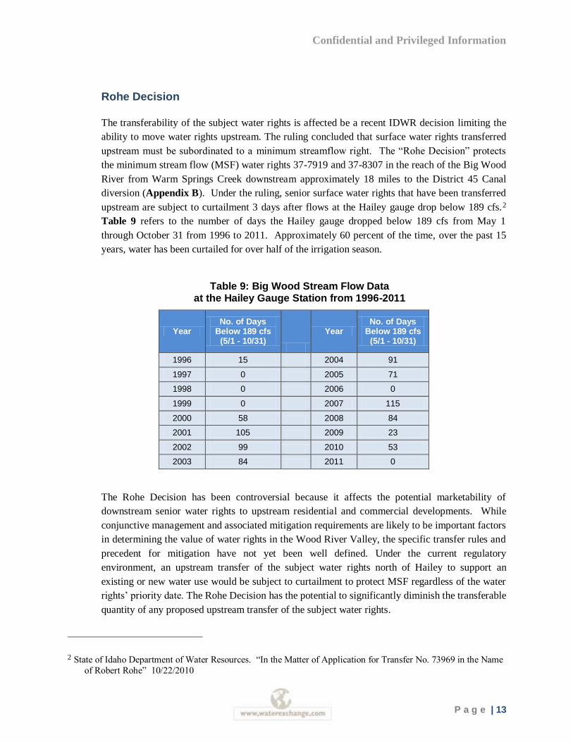
upstream are subject to curtailment 3 days after flows at the Hailey gauge drop below 189 cfs.2
Table 9 refers to the number of days the Hailey gauge dropped below 189 cfs from May 1
through October 31 from 1996 to 2011. Approximately 60 percent of the time, over the past 15
years, water has been curtailed for over half of the irrigation season.
Table 9: Big Wood Stream Flow Data at the Hailey Gauge Station from 1996-2011
Year No. of Days
Below 189 cfs (5/1 - 10/31)
Year No. of Days
Below 189 cfs (5/1 - 10/31)
1996 15 2004 91
1997 0 2005 71
1998 0 2006 0
1999 0 2007 115
2000 58 2008 84
2001 105 2009 23
2002 99 2010 53
2003 84 2011 0
The Rohe Decision has been controversial because it affects the potential marketability of
downstream senior water rights to upstream residential and commercial developments. While
conjunctive management and associated mitigation requirements are likely to be important factors
in determining the value of water rights in the Wood River Valley, the specific transfer rules and
precedent for mitigation have not yet been well defined. Under the current regulatory
environment, an upstream transfer of the subject water rights north of Hailey to support an
existing or new water use would be subject to curtailment to protect MSF regardless of the water
rights’ priority date. The Rohe Decision has the potential to significantly diminish the transferable
quantity of any proposed upstream transfer of the subject water rights.
2 State of Idaho Department of Water Resources. “In the Matter of Application for Transfer No. 73969 in the Name
of Robert Rohe” 10/22/2010
Confidential and Privileged Information
P a g e | 14
Conjunctive Management Mitigation
It is expected that IDWR will enforce conjunctive management of ground and surface water
rights within the next 5 - 10 years. This will require existing junior water right users to either
curtail water use during low flow periods or mitigate water use through acquisition of a senior
surface water right or other means (e.g. development of new storage, aquifer recharge, etc.).
While IDWR has not established formal standards for mitigation, it is important to note that only
outdoor water use will require mitigation.3 Indoor water uses associated with junior priority water
rights will not be affected by conjunctive management.
While there are a number of methods potentially available to mitigate for out-of-priority water
uses, acquisition of senior, surface water rights is anticipated to be a primary approach. To
provide fully effective mitigation, the surface water right will need to be reliable enough to allow
continued water use during the irrigation season. The local Watermaster provided some baseline
estimates relative to potential mitigation transfers of senior surface water rights.4 Fully reliable
water rights for all uses are considered to be water rights with priority dates of 1882 and senior.
Water rights with 1883 priority dates are also considered to be very reliable water rights, but have
been occasionally curtailed for relatively brief periods in the past. According to the local
watermaster, water rights with priority dates of 1884 and 1885 are considered the less reliable and
may not provide for full mitigation depending on the type of mitigation that would be proposed.
Water rights junior to 1885 are currently not considered reliable enough to provide full mitigation
for outdoor water use. The level of mitigation required under a conjunctive use regime will
depend upon the impact of water use on flows in the Big Wood River although the rules and
process for quantifying impacts have not been established by IDWR.
Transferability Summary
While there are seven water rights associated with the QCR, water right 37-19736, with an 1880
priority date, is the only water right that can be used for mitigation of junior priority water rights.
The potential market region for the subject water rights is currently limited to a downstream
transfer as clarified by the Rohe decision. To avoid significant reductions to the transferable
quantity and subordination to MSF, this analysis assumes the market for the water rights is
limited to new uses and mitigation of existing uses from the City of Hailey and downstream.
3 Personal communication with Brian Patton, IDWR, January, 2012
4 Conversation with Kevin Lakey, Water District 37 Watermaster, January 10, 2012
Confidential and Privileged Information
P a g e | 15
Reliability and Seniority
The legal characteristics of a water right can have significant impact on value. Each water right
has a priority date that refers to the date it was established. The priority date and seniority of a
water right has particular importance in this region because it determines the likelihood that water
will be available for use under drought conditions and will satisfy the potential future mitigation
needs of junior water users. To address water right reliability, past water use history and water
availability specific to water right 37-19736 is reviewed.
According to ERO, the Water District 37/37M Watermaster does not now and has not historically
curtailed diversions from Quigley Creek to satisfy earlier priority rights calling for water from
Big Wood River and tributaries. Moreover, the Watermaster has traditionally recognized that
calling for water from Quigley Creek for delivery to the Big Wood River would not add to water
availability to downstream Wood River water right holders (“futile” call). The SRBA court
confirmed this understanding by issuing partial decrees listing Quigley Creek as tributary to
“sinks”, although Quigley Creek is not listed as a separate source in the General Provisions for
the basin.5 Water right 37-19736 is not tributary to the Wood River and there have been no
hydrologic studies to assist in determining the conditions under which they could be transferred to
another water user located on the Wood River. As a result, this analysis relies primarily upon
estimates of water availability from Quigley Creek to assess reliability.
Water Availability
The water available to divert under water right 37-19736 is an important consideration when
assessing reliability for mitigation purposes. This section identifies the water available to divert
from Quigley Creek under water right 37-19736. ERO has described Quigley Creek flows as
follows: Quigley Creek is a spring-fed stream with a stable base flow that does not exhibit the
large variation in flow of mountain streams only fed directly by snow melt and precipitation
events. Hydrographs demonstrate that the base flow during the irrigation season is usually closer
to the flow rate authorized by water right 37-19736.6
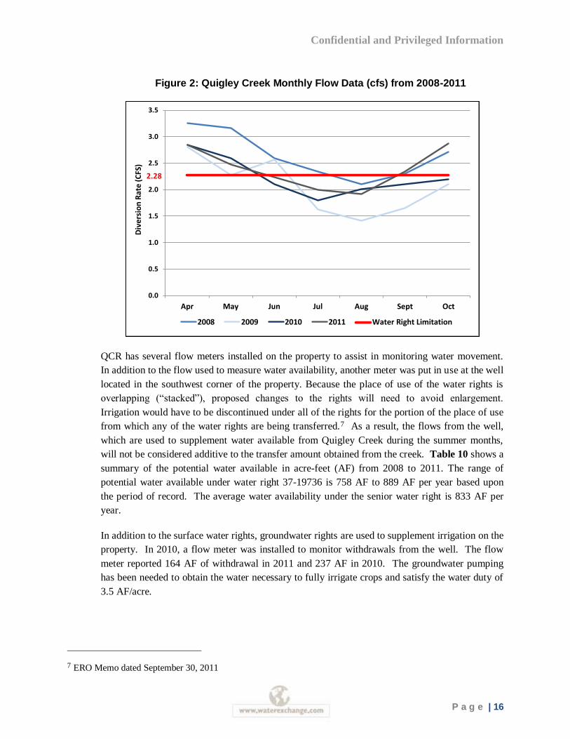
Figure 2 shows average monthly flows on Quigley Creek during the irrigation season (April –
October) from 2008 to 2011. Flow data was collected by the current owner from a stream gage
located just above the reservoir. The lesser of the available flow in Quigley Creek and the
allowed diversion rate of water right 37-19736 was used to estimate water availability. Actual
diversions associated with irrigation on the place of use were not obtained as part of the analysis.
During June, July and August, flows in Quigley Creek, above the reservoir, have historically been
below the authorized diversion rate associated with water right 37-19736. In contrast, excess
water typically available early and late in the irrigation season on Quigley Creek was not
considered available.
5 ERO Memo dated September 30, 2011
6 SPF Memo dated November 12, 2009
Confidential and Privileged Information
P a g e | 16
Figure 2: Quigley Creek Monthly Flow Data (cfs) from 2008-2011
QCR has several flow meters installed on the property to assist in monitoring water movement.
In addition to the flow used to measure water availability, another meter was put in use at the well
located in the southwest corner of the property. Because the place of use of the water rights is
overlapping (“stacked”), proposed changes to the rights will need to avoid enlargement.
Irrigation would have to be discontinued under all of the rights for the portion of the place of use
from which any of the water rights are being transferred.7 As a result, the flows from the well,
which are used to supplement water available from Quigley Creek during the summer months,
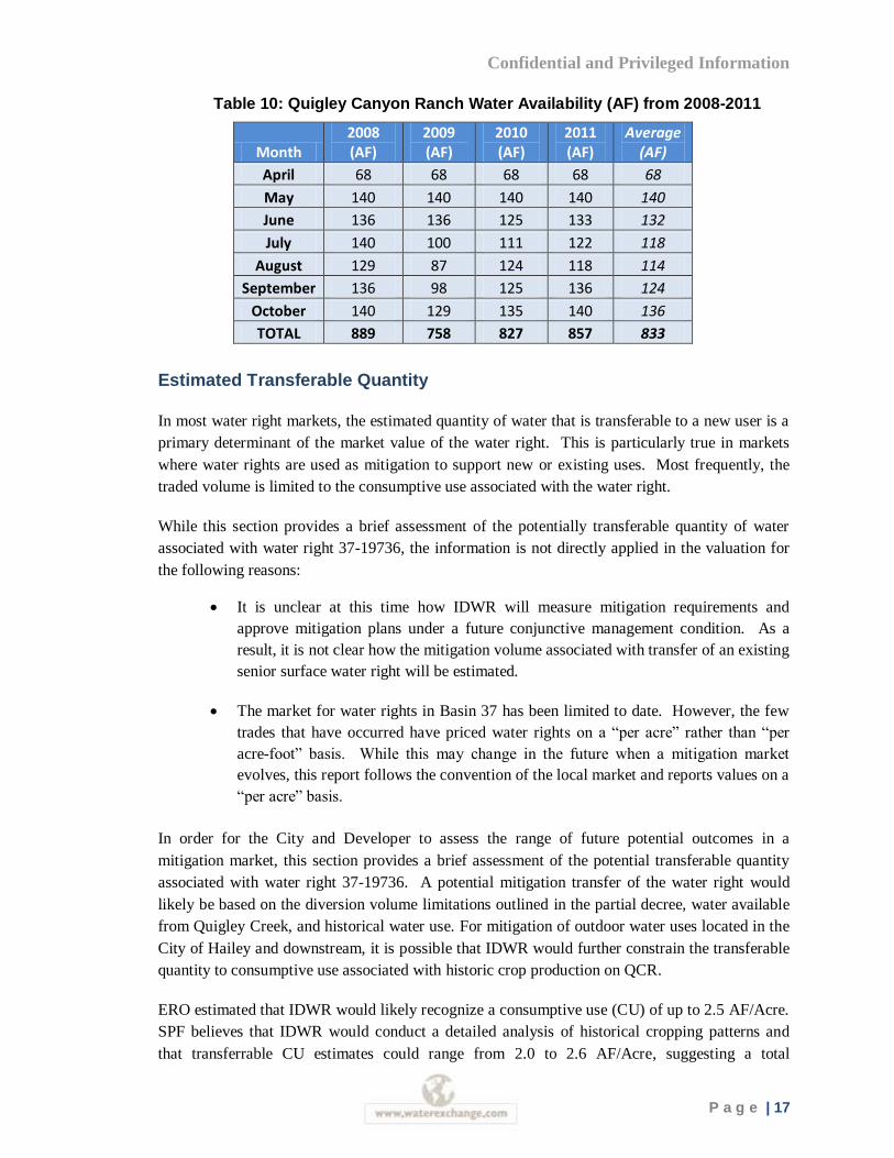
will not be considered additive to the transfer amount obtained from the creek. Table 10 shows a
summary of the potential water available in acre-feet (AF) from 2008 to 2011. The range of
potential water available under water right 37-19736 is 758 AF to 889 AF per year based upon
the period of record. The average water availability under the senior water right is 833 AF per
year.
In addition to the surface water rights, groundwater rights are used to supplement irrigation on the
property. In 2010, a flow meter was installed to monitor withdrawals from the well. The flow
meter reported 164 AF of withdrawal in 2011 and 237 AF in 2010. The groundwater pumping
has been needed to obtain the water necessary to fully irrigate crops and satisfy the water duty of
3.5 AF/acre.
7 ERO Memo dated September 30, 2011
0.0
0.5
1.0
1.5
2.0
2.5
3.0
3.5
Apr May Jun Jul Aug Sept Oct
Div
ersi
on
Rat
e (C
FS)
2008 2009 2010 2011 Water Right Limitation
2.28
Confidential and Privileged Information
P a g e | 17
Table 10: Quigley Canyon Ranch Water Availability (AF) from 2008-2011
Month 2008 (AF)
2009 (AF)
2010 (AF)
2011 (AF)
Average (AF)
April 68 68 68 68 68
May 140 140 140 140 140
June 136 136 125 133 132
July 140 100 111 122 118
August 129 87 124 118 114
September 136 98 125 136 124
October 140 129 135 140 136
TOTAL 889 758 827 857 833
Estimated Transferable Quantity
In most water right markets, the estimated quantity of water that is transferable to a new user is a
primary determinant of the market value of the water right. This is particularly true in markets
where water rights are used as mitigation to support new or existing uses. Most frequently, the
traded volume is limited to the consumptive use associated with the water right.
While this section provides a brief assessment of the potentially transferable quantity of water
associated with water right 37-19736, the information is not directly applied in the valuation for
the following reasons:
It is unclear at this time how IDWR will measure mitigation requirements and
approve mitigation plans under a future conjunctive management condition. As a
result, it is not clear how the mitigation volume associated with transfer of an existing
senior surface water right will be estimated.
The market for water rights in Basin 37 has been limited to date. However, the few
trades that have occurred have priced water rights on a “per acre” rather than “per
acre-foot” basis. While this may change in the future when a mitigation market
evolves, this report follows the convention of the local market and reports values on a
“per acre” basis.
In order for the City and Developer to assess the range of future potential outcomes in a
mitigation market, this section provides a brief assessment of the potential transferable quantity
associated with water right 37-19736. A potential mitigation transfer of the water right would
likely be based on the diversion volume limitations outlined in the partial decree, water available
from Quigley Creek, and historical water use. For mitigation of outdoor water uses located in the
City of Hailey and downstream, it is possible that IDWR would further constrain the transferable
quantity to consumptive use associated with historic crop production on QCR.
ERO estimated that IDWR would likely recognize a consumptive use (CU) of up to 2.5 AF/Acre.
SPF believes that IDWR would conduct a detailed analysis of historical cropping patterns and
that transferrable CU estimates could range from 2.0 to 2.6 AF/Acre, suggesting a total
Confidential and Privileged Information
P a g e | 18
transferable volume of 553 to 719 AF.8 It was also suggested that development of a pipeline
from QCR to the Wood River may allow for the full diversion volume (883 AF/yr, on average) to
be applied to mitigation uses.9 As a result, the potential range of volume applicable to a future
mitigation market may range from 553 to 833 AF.
Alternative Water Supplies
The availability of alternative water supplies in the market area is an important price
consideration. Water right prices tend to be lower in areas where there are alternative water
supplies available to meet existing demands. In contrast, water prices are higher in regions that
have little water available to support new uses or have water sources that are costly to develop.
Surface Water
In 1980, the IDWR Director issued a policy memorandum declaring that the surface water of the
Big Wood River upstream from Magic Reservoir was fully appropriated. Since that date, no new
permits for consumptive purposes have been issued for the use of the river or any of its
tributaries.10
Groundwater
The Big Wood River Ground Water Management Area (GWMA) was designated by Order of the
Director on June 28, 1991. The GWMA was designated to address the connection between
ground and surface water within the Camas Creek, Silver Creek, and Upper Big Wood River
drainages above Magic Reservoir. IDWR determined that junior ground water diversions were
depleting senior surface water flows in the Big Wood River and Silver Creek. The management
policy associated with the current designation allows for the consideration of new ground water
withdrawals; however, applicants are required to demonstrate there will be no injury or can
provide acceptable mitigation to prior water rights.11 Due to constraints on the availability of
new water rights in Blaine County, the ability to develop a new water source without first
acquiring an existing, valid water right is limited. Most new water uses will require the
acquisition of an existing water right, either for direct use or mitigation.
8 SPF Memo dated June 23, 2011
9 ERO Memo dated September 30, 2011
10 See http://www.idwr.idaho.gov/WaterInformation/GroundWaterManagement/BigWoodRiver/PDFs/bw_gwma-order_create.pdf
11 See http://www.idwr.idaho.gov/WaterInformation/GroundWaterManagement/BigWoodRiver/bw_gwma.htm
Confidential and Privileged Information
P a g e | 19
Water Supply and Demand Assessment
This section generally describes regional water supply and demand conditions in the region to
assess the marketability and potential end uses of the subject water rights. Regional economic
conditions can influence the value of water by stressing available supplies and affecting the ease
and cost with which new water supplies can be developed. The current and projected demand for
water must be considered in conjunction with an analysis of available water supplies. The
following assessment includes a review of surface and groundwater supplies and regional water
demand projections.
Regional Water Supply
Both ground and surface water sources are used to provide water supply in the Wood River
Valley. The population of the Wood River Valley depends primarily on groundwater for domestic
supply, either from privately owned or municipal wells; surface water is primarily used for
recreation/aesthetics and irrigation.
Surface Water
A majority of the Wood River Valley is drained by the Big Wood River or its tributaries, except
for the southeastern portion of the Bellevue fan, which is drained by Silver Creek, a tributary to
the Little Wood River. The Big Wood River originates near Galena Summit, approximately 20
miles northwest of Ketchum, and gains flow from a number of tributaries. At Bellevue, the
channel follows the western side of the Bellevue fan, exiting the valley at the Big Wood River at
Stanton Crossing near Bellevue gauging station.12
Groundwater
The entire population of the area depends on groundwater for domestic supply, either from
domestic or municipal wells. Rapid population growth since the 1970s has raised concerns about
the long-term sustainability of the groundwater resource. On August 16, 2011, IDWR held a
public hearing in Hailey, Idaho to explain the creation of a water measurement district to serve as
an interim step in the establishment of a water district. Notices were sent to 500 groundwater
right holders within the basin in connection with the creation of the measurement district,
excluding domestic, stock, and non-irrigation groundwater rights (less than 0.24 cfs diversion
rate).
According to IDWR, there are approximately 800 groundwater rights associated with 750 unique
well locations throughout the basin. Of all the groundwater rights in the basin, there are 537
groundwater rights used for irrigating five acres or more with diversion rates greater than 0.24
12 Ground-Water Budgets for the Wood River Valley Aquifer System, South-Central Idaho, 1995–2004, USGS
Scientific Investigations Report 2009-5016.
Confidential and Privileged Information
P a g e | 20
cfs. There are 258 groundwater rights used for irrigation of less than 5 acres. The water rights
granted to support the irrigation of less than 5 acres represent a small minority of estimated
overall withdrawals (3 percent).
Regional Water Demand
This section estimates the demand for water in Blaine County. The upper (northern) portion of the
county is more developed and contains the incorporated communities of Sun Valley, Ketchum,
Hailey and Bellevue. Land use in the upper valley is predominately residential with many large
homes situated on landscaped acreage. The lower (southern) portion of the county is dominated
by farms and ranches (irrigated by groundwater and diverted surface water) and contains the
small communities of Gannett and Picabo. The Big Wood River watershed comprises the
majority of Blaine County. Of the total acreage in the Big Wood River watershed, an estimated
220,030 acres are privately owned. Approximately, 191,587 of these acres are used for
agricultural purposes, such as, irrigated cropland and pasture, rangeland, riparian grazing, and
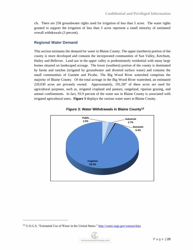
animal confinements. In fact, 93.9 percent of the water use in Blaine County is associated with
irrigated agricultural users. Figure 3 displays the various water users in Blaine County.
Figure 3: Water Withdrawals in Blaine County13
13 U.S.G.S, “Estimated Use of Water in the United States.” http://water.usgs.gov/watuse/data
Public2.9%
Industrial2.7%
Domestic0.4%
Irrigation93.9%
Confidential and Privileged Information
P a g e | 21
Urban Water Demand
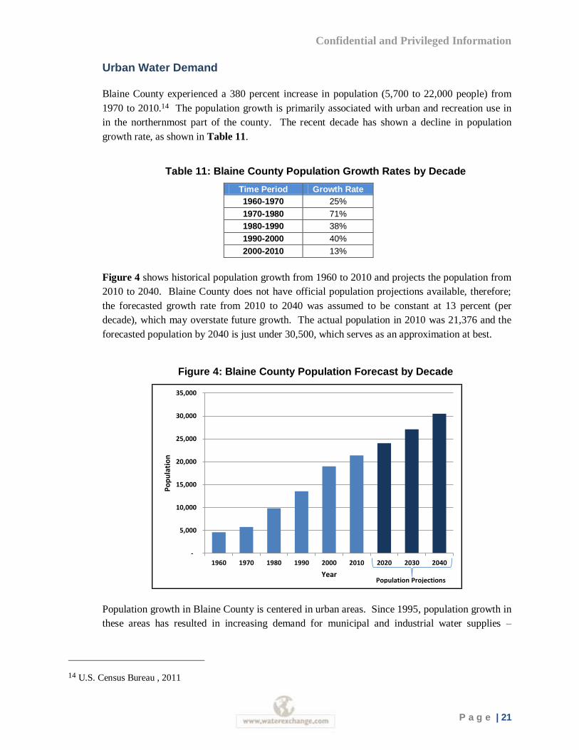
Blaine County experienced a 380 percent increase in population (5,700 to 22,000 people) from
1970 to 2010.14 The population growth is primarily associated with urban and recreation use in
in the northernmost part of the county. The recent decade has shown a decline in population
growth rate, as shown in Table 11.
Table 11: Blaine County Population Growth Rates by Decade
Time Period Growth Rate
1960-1970 25%
1970-1980 71%
1980-1990 38%
1990-2000 40%
2000-2010 13%
Figure 4 shows historical population growth from 1960 to 2010 and projects the population from
2010 to 2040. Blaine County does not have official population projections available, therefore;
the forecasted growth rate from 2010 to 2040 was assumed to be constant at 13 percent (per
decade), which may overstate future growth. The actual population in 2010 was 21,376 and the
forecasted population by 2040 is just under 30,500, which serves as an approximation at best.
Figure 4: Blaine County Population Forecast by Decade
Population growth in Blaine County is centered in urban areas. Since 1995, population growth in
these areas has resulted in increasing demand for municipal and industrial water supplies –
14 U.S. Census Bureau , 2011
-
5,000
10,000
15,000
20,000
25,000
30,000
35,000
1960 1970 1980 1990 2000 2010 2020 2030 2040
Po
pu
lati
on
YearPopulation Projections
Confidential and Privileged Information
P a g e | 22
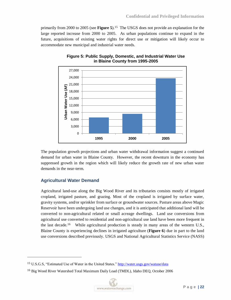
primarily from 2000 to 2005 (see Figure 5).15 The USGS does not provide an explanation for the
large reported increase from 2000 to 2005. As urban populations continue to expand in the
future, acquisitions of existing water rights for direct use or mitigation will likely occur to
accommodate new municipal and industrial water needs.
Figure 5: Public Supply, Domestic, and Industrial Water Use in Blaine County from 1995-2005
The population growth projections and urban water withdrawal information suggest a continued
demand for urban water in Blaine County. However, the recent downturn in the economy has
suppressed growth in the region which will likely reduce the growth rate of new urban water
demands in the near-term.
Agricultural Water Demand
Agricultural land-use along the Big Wood River and its tributaries consists mostly of irrigated
cropland, irrigated pasture, and grazing. Most of the cropland is irrigated by surface water,
gravity systems, and/or sprinkler from surface or groundwater sources. Pasture areas above Magic
Reservoir have been undergoing land use changes, and it is anticipated that additional land will be
converted to non-agricultural related or small acreage dwellings. Land use conversions from
agricultural use converted to residential and non-agricultural use land have been more frequent in
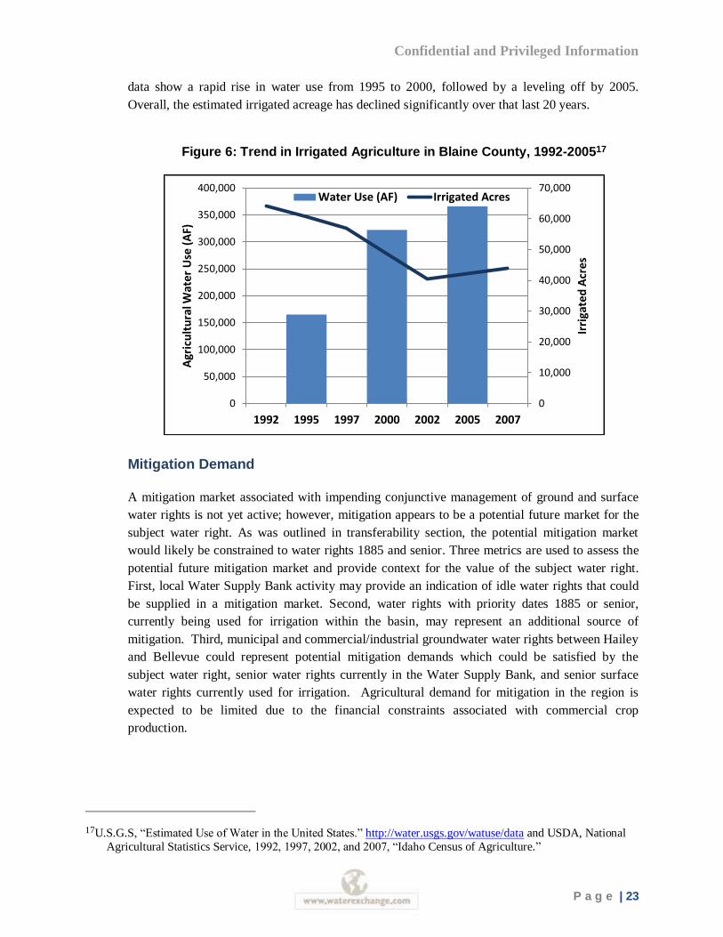
the last decade.16 While agricultural production is steady in many areas of the western U.S.,
Blaine County is experiencing declines in irrigated agriculture (Figure 6) due in part to the land
use conversions described previously. USGS and National Agricultural Statistics Service (NASS)
15 U.S.G.S, “Estimated Use of Water in the United States.” http://water.usgs.gov/watuse/data
16 Big Wood River Watershed Total Maximum Daily Load (TMDL), Idaho DEQ, October 2006
0
3,000
6,000
9,000
12,000
15,000
18,000
21,000
24,000
27,000
1995 2000 2005
Urb
an W
ate
r U
se (
AF)
Confidential and Privileged Information
P a g e | 23
data show a rapid rise in water use from 1995 to 2000, followed by a leveling off by 2005.
Overall, the estimated irrigated acreage has declined significantly over that last 20 years.
Figure 6: Trend in Irrigated Agriculture in Blaine County, 1992-200517
Mitigation Demand
A mitigation market associated with impending conjunctive management of ground and surface
water rights is not yet active; however, mitigation appears to be a potential future market for the
subject water right. As was outlined in transferability section, the potential mitigation market
would likely be constrained to water rights 1885 and senior. Three metrics are used to assess the
potential future mitigation market and provide context for the value of the subject water right.
First, local Water Supply Bank activity may provide an indication of idle water rights that could
be supplied in a mitigation market. Second, water rights with priority dates 1885 or senior,
currently being used for irrigation within the basin, may represent an additional source of
mitigation. Third, municipal and commercial/industrial groundwater water rights between Hailey
and Bellevue could represent potential mitigation demands which could be satisfied by the
subject water right, senior water rights currently in the Water Supply Bank, and senior surface
water rights currently used for irrigation. Agricultural demand for mitigation in the region is
expected to be limited due to the financial constraints associated with commercial crop
production.
17U.S.G.S, “Estimated Use of Water in the United States.” http://water.usgs.gov/watuse/data and USDA, National
Agricultural Statistics Service, 1992, 1997, 2002, and 2007, “Idaho Census of Agriculture.”
0
10,000
20,000
30,000
40,000
50,000
60,000
70,000
0
50,000
100,000
150,000
200,000
250,000
300,000
350,000
400,000
1992 1995 1997 2000 2002 2005 2007
Irri
gate
d A
cres
Agr
icu
ltu
ral W
ate
r U
se (
AF)
Water Use (AF) Irrigated Acres
Confidential and Privileged Information
P a g e | 24
Water Supply Bank
Currently, there is water available for rent in the Wood River Basin through the local water
supply bank. In general, less water is leased to the water supply bank than is rented from it
indicating relatively low demand for annual uses of water in the current market. In 2010, IDWR
reported 33 leases in the basin to the water supply bank and 16 of those as rented. There are
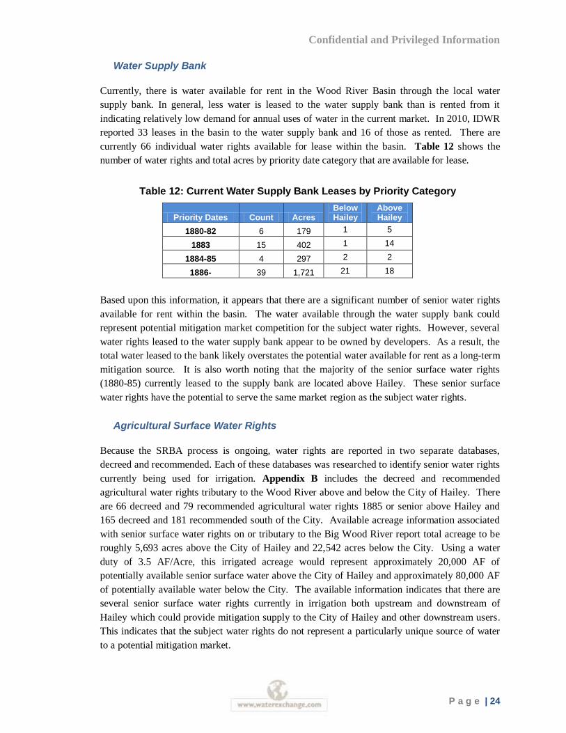
currently 66 individual water rights available for lease within the basin. Table 12 shows the
number of water rights and total acres by priority date category that are available for lease.
Table 12: Current Water Supply Bank Leases by Priority Category
Priority Dates Count Acres Below Hailey
Above Hailey
1880-82 6 179 1 5
1883 15 402 1 14
1884-85 4 297 2 2
1886- 39 1,721 21 18
Based upon this information, it appears that there are a significant number of senior water rights
available for rent within the basin. The water available through the water supply bank could
represent potential mitigation market competition for the subject water rights. However, several
water rights leased to the water supply bank appear to be owned by developers. As a result, the
total water leased to the bank likely overstates the potential water available for rent as a long-term
mitigation source. It is also worth noting that the majority of the senior surface water rights
(1880-85) currently leased to the supply bank are located above Hailey. These senior surface
water rights have the potential to serve the same market region as the subject water rights.
Agricultural Surface Water Rights
Because the SRBA process is ongoing, water rights are reported in two separate databases,
decreed and recommended. Each of these databases was researched to identify senior water rights
currently being used for irrigation. Appendix B includes the decreed and recommended
agricultural water rights tributary to the Wood River above and below the City of Hailey. There
are 66 decreed and 79 recommended agricultural water rights 1885 or senior above Hailey and
165 decreed and 181 recommended south of the City. Available acreage information associated
with senior surface water rights on or tributary to the Big Wood River report total acreage to be
roughly 5,693 acres above the City of Hailey and 22,542 acres below the City. Using a water
duty of 3.5 AF/Acre, this irrigated acreage would represent approximately 20,000 AF of
potentially available senior surface water above the City of Hailey and approximately 80,000 AF
of potentially available water below the City. The available information indicates that there are
several senior surface water rights currently in irrigation both upstream and downstream of
Hailey which could provide mitigation supply to the City of Hailey and other downstream users.
This indicates that the subject water rights do not represent a particularly unique source of water
to a potential mitigation market.
Confidential and Privileged Information
P a g e | 25
Municipal and Commercial/Industrial Water Rights
Municipal and commercial/industrial groundwater rights could represent a potential demand for
mitigation in a conjunctive management scenario.
The Wood River Basin contains 41 groundwater rights classified as municipal. The City of
Ketchum was not considered a potential demand for the subject water rights given the effects of
the Rohe decision. Furthermore, the Cities of Fairfield, Bliss, Shoshone, Picabo and Carey are
considered outside the likely mitigation market region for the subject water right. The Cities of
Hailey and Bellevue are municipalities with groundwater rights that may require mitigation. The
City of Bellevue indicated they would not need to enter a potential mitigation market to purchase
mitigation water as its current water rights portfolio is sufficient to mitigate any junior priority
groundwater rights.18 As a result, municipal demand for mitigation that could be provided by the
subject water right appears to be limited to the City of Hailey.
There are a total of 79 commercial/industrial groundwater rights in the Wood River Valley, but
only three of the water rights are located between Hailey and Bellevue, the mitigation market
region for the subject water right. Combined, the three water rights allow the withdrawal of less
than 8 AF per year. As a result, the potential commercial/industrial mitigation demand that could
be provided by the subject water right appears to be limited.
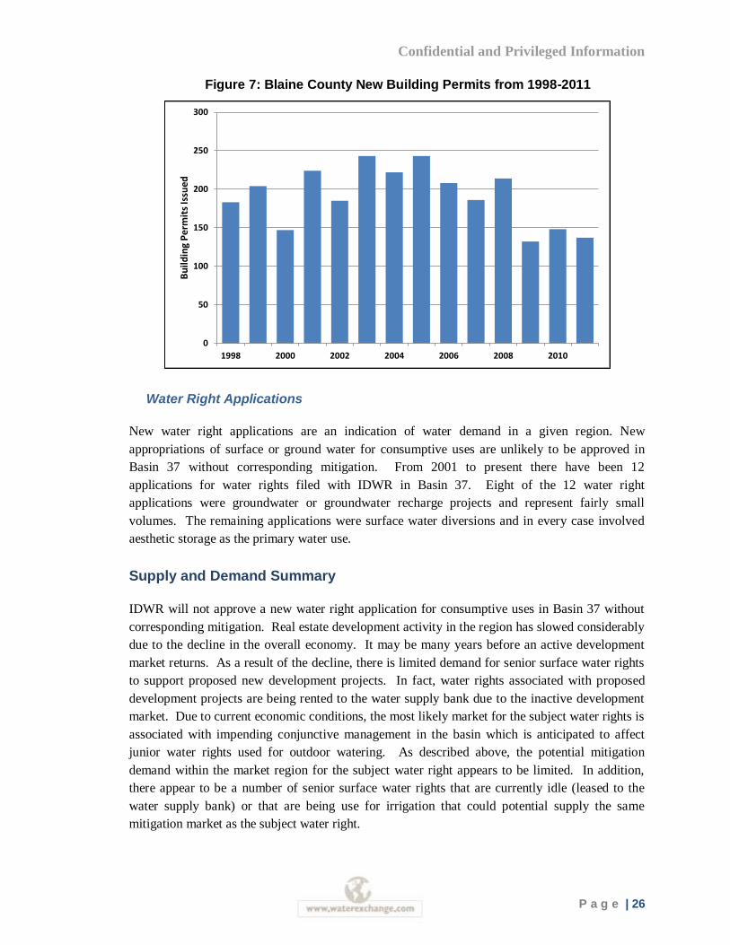
Current Economic Conditions
Water and water rights are an input in the production of goods and services from agricultural
crops to houses. The slowdown in the economy has impacted Blaine County and may be affecting
the market and value for water rights. Throughout the county, the number of homes and lots sold
has greatly declined during the last several years as has the total value of homes sold.
Furthermore, new building permit applications have significantly declined since 2008. This
decline in growth is limiting the conversions from irrigation to urban water use in the basin (see
Figure 7).
18 Conversation with David Bucklin, City of Bellevue, January, 2012
Confidential and Privileged Information
P a g e | 26
Figure 7: Blaine County New Building Permits from 1998-2011
Water Right Applications
New water right applications are an indication of water demand in a given region. New
appropriations of surface or ground water for consumptive uses are unlikely to be approved in
Basin 37 without corresponding mitigation. From 2001 to present there have been 12
applications for water rights filed with IDWR in Basin 37. Eight of the 12 water right
applications were groundwater or groundwater recharge projects and represent fairly small
volumes. The remaining applications were surface water diversions and in every case involved
aesthetic storage as the primary water use.
Supply and Demand Summary
IDWR will not approve a new water right application for consumptive uses in Basin 37 without
corresponding mitigation. Real estate development activity in the region has slowed considerably
due to the decline in the overall economy. It may be many years before an active development
market returns. As a result of the decline, there is limited demand for senior surface water rights
to support proposed new development projects. In fact, water rights associated with proposed
development projects are being rented to the water supply bank due to the inactive development
market. Due to current economic conditions, the most likely market for the subject water rights is
associated with impending conjunctive management in the basin which is anticipated to affect
junior water rights used for outdoor watering. As described above, the potential mitigation
demand within the market region for the subject water right appears to be limited. In addition,
there appear to be a number of senior surface water rights that are currently idle (leased to the
water supply bank) or that are being use for irrigation that could potential supply the same
mitigation market as the subject water right.
0
50
100
150
200
250
300
1998 2000 2002 2004 2006 2008 2010
Bu
ildin
g P
erm
its
Issu
ed
Confidential and Privileged Information
P a g e | 27
Water Rights Valuation
Highest and Best Use
The valuation is based upon a determination of the highest and best use for the subject water
rights. Highest and best use is defined as “the highest and most profitable use for which the
property is adapted and needed or likely to be needed in the near future.” Under Idaho water law,
the subject water rights can be transferred to other uses and locations. However, there are a
number of restrictions that limit transfer opportunities. Continuing to use the water rights on the
property would keep the portfolio of water rights intact, but the value of the water under this
scenario would only represent the contributory value of its current use for irrigation. The highest
and best use of the subject water rights would be the transfer of the senior priority water right (37-
19736) as mitigation for a junior priority water use under a conjunctive management scenario.
However, apart from Hailey, an expressed demand for municipal mitigation was not clearly
identified.
Valuation Methodology
The selection of appropriate valuation technique(s) is determined by the characteristics and nature
of the subject water rights as well as the availability and quality of information. There are a
variety of approaches available to estimate the value of a specific water resource. The methods
available to value water resources are briefly described below:
Sales Comparison Approach: The Sales Comparison Approach compares the subject
water right with similar water rights that have been sold or leased to determine market
value. A reasonable number of sales are required to make accurate comparisons. Where
necessary, adjustments should be applied to account for differences in physical and legal
characteristics and market conditions between the comparable sales and the subject water
right. This is the preferred valuation methodology when comparable information is
available. Due to the limited current and historic water right trading activity, the decline
in development activity and the uncertainties surrounding future conjunctive management
and mitigation rules, implementation of a traditional sales comparison approach is
particularly challenging. However, this analysis pursued identification of water right
sales in the region to assist in establishing a value for the subject water rights.
Income Capitalization Approach: The Income Capitalization Approach estimates the
value of a water source according to the contribution that water provides to net income
for a business. The method is based upon the expectations of future benefits from the
water and often can be subject to speculation if the future benefits are associated with a
new rather than current use. The method is often applied to water leases to arrive at a
capitalized value. This method was not considered in valuing the subject water right as
there is not an active rental market for water rights in the Wood River Basin.
Confidential and Privileged Information
P a g e | 28
Land Price Differential Approach: The Land Price Differential Approach, also referred
to as the “before and after” analysis, estimates the value of the larger parcel including the
right to access a water resource and considers the value in the absence of access to water.
The method, which is an application of hedonic price analysis, uses the difference in the
property’s value with and without access to water to estimate the contribution that water
rights provide to the overall sale price. In some markets, the price of land with senior
water rights provides important market information that can be applied to estimate the
value of senior water rights sold separately from land. Land sales data and listing
information were collected throughout Blaine County. Due to the limited amount of
transactions, a statistical analysis could not be conducted. However, a narrative of the
land sales market is included to provide additional context to the water rights market and
to augment the comparable sales valuation approach.
Cost Replacement Approach: Under some limited circumstances, the cost of
developing alternative water supplies similar to that provided by the subject water
resource can be used to establish value. This approach requires specific knowledge about
the range of opportunities and costs associated with water development. In addition to
the acquisition of senior surface water rights, new surface storage and aquifer recharge
could represent an alternative method of providing mitigation for out-of-priority uses.
There are no known projects that are being actively pursued that can be used to identify
the feasibility and costs of alternatives. As a result, the cost approach is not pursued in
this analysis.
Sales Comparison Approach
WestWater maintains a database of water rights transfers that have occurred in the State of Idaho.
The database accounts for sales and leases of water rights from 2000 to present. In addition,
irrigated land sales were researched within Blaine County. The following sections describe water
right sales in the region and provide an overview of the irrigated land market in the area to assist
in estimating the value for the subject water rights.
Water Right Sales
Few transfers involving the sale of water rights separate from land were recorded from 2007 to
the current date within the Wood River Basin. Of the transfers that are taking place in the area,
nearly all of them involve changes in place of use or point of diversion without a change in
ownership. Other fairly common types of transfers in the basin include splitting the right for the
purpose of subdividing the land for lot development. In this situation, the water right is being
sold with the lot or with the subdivision itself which makes it difficult to separate the value of the
water right from the price of the land. In order to identify relevant water right sales in the Wood
River Basin, the following research process was implemented.
1. WestWater requested information on all water right transfer applications received by
Idaho Department of Water Resources (IDWR) from July 1, 2007 to present. The
Confidential and Privileged Information
P a g e | 29
request resulted in an extensive list of water right transfers that took place throughout
Idaho. It was narrowed down to Basin 37 specific transfers. This resulted in 224
potential water rights sales to be considered and analyzed.
2. Water right transfers that appeared not to represent a market transaction were
eliminated. For instance, if water rights were transferred between family members or
from members of the family trust to the trust itself, they were removed from potential
sales list. Also transactions recorded several times were grouped together to
eliminate double counting. This resulted in 193 potential, unique transactions.
3. The next step in the research process was to compare the 193 potential transactions
with changes in POU and nature of use against water right ownership changes over
the same timeframe. Change to the place of use and/or in the nature of use is a strong
indicator of a market transaction. Out of the 193 water right transfers reviewed with
accompanying ownership updates, three reported changes in the place of use, while
one reported a change in the nature of use, and nine listed changes in both place and
nature of use. Table 13 illustrates nine individual transactions that were further
reviewed. Five water transactions were identified through this screening process.
Details of each water right transaction were confirmed through personal
communications with parties involved in transactions.
4. There is typically a backlog on processing water transfers, so in addition to the water
right research conducted through IDWR, deeds were researched from the Blaine
County Clerk’s Office to identify any further water market activity. Most of the
deeds researched were land and water deals and did not necessarily reflect the true
value of the water in Blaine County.
Confidential and Privileged Information
P a g e | 30
Table 13: Wood River Basin Sale Leads from 2007-2011
Water
Right
Change
Year
Change
Type
Priority
Date Water Use Current Owner
Previous
Owners Sale Type
37-482 2011 POU 8/1/1884 Irrigation Mountain West Bank South County Estates LLC
Land Sale
37-2568 2008 POU 4/25/1955 Irrigation Thomas O'Gara
Family Trust
Nisson,
Delores Land Sale
37-297 2011 N 11/26/1886 Aesthetic Storage Thorson, Jon Johnson,
Craig Land Sale.
37-577 2008 POU, N 3/24/1883 Irrigation Thomas O'Gara
Family Trust Nisson, Delores
Land Sale
37-21956 2007 POU 3/24/1883
Irrigation,
Recreation
Mitigation
Robert Rohe David
Cropper
Water
rights sale
37-22313
2010 POU, N 3/24/1883 Groundwater
Recharge Dry Lot LLC
Old Cutters
Inc.
Water
rights sale 37-22318
37-22323
37-21130
2007 POU, N 3/24/1883 Irrigation City of Hailey Old Cutters
Inc.
Water
rights sale 37-21137
37-21139
37-22328 2008 POU, N 12/14/1974 Irrigation Webb Landscape Idaho Water
Company
Water
rights sale
37-22656 2011 POU, N 12/14/1974 Irrigation
Mitigation Nancie Tatum
Robert
Wagner
Water
rights sale
Table 14 summarizes five water right transactions identified in the Wood River Basin. Prices for
surface rights ranged from roughly $27,000 to $30,000 per acre and with the volume ranging
from 3.5 to 108 AF. Groundwater right sales involved small volumes of water and sold at lower
prices. In fact, the price for both groundwater right trades was $16,500 per acre ($4,714/AF) even
though they occurred several years apart. Each sale will be reviewed in detail.
Table 14: Wood River Basin Transactions from 2007-2011
Water
Rights
WR
Type Seller Buyer Date
Volume
(AF) Acres
Price
($/Acre)
37-21130
37-21137
37-21139
Surface
Old
Cutters,
Inc.
City of
Hailey 2007 108.5 31 $30,000
37-22313
37-22318
37-22323
Surface
Old
Cutters,
Inc.
Dry Lot,
LLC 2007 96.25 27.5 $27,273
37-21956 Surface David
Cropper
Robert
Rohe 2007 3.5 1 $28,000
37-22328 GW
Idaho
Water
Company
Webb
Landscape 2008 21 6 $16,500
37-22656 GW Robert Wagner
Idaho
Water Company
2011 7 2 $16,500
Confidential and Privileged Information
P a g e | 31
Old Cutters Inc. to Dry Lot, LLC Sale
Old Cutters Inc. (OCI) was developing the Old Cutters Subdivision in the Hailey, ID area.
According to the development agreement OCI retained ownership of all water rights appurtenant
to the Subdivision and was able to sell or move those water rights off the proposed Subdivision.
The water rights involved in the transfer were 37-21130, 37-21137, 37-21139 which authorized
diversion from the Big Wood River and limited to the irrigation of 66 acres of land combined.
All water rights involved had a senior surface priority date of March 24, 1883.
In 2007, OCI entered into an agreement with Dry Lot, LLC to sell surface water rights. The goal
of the water right acquisition was to assure that an additional 27.5 acres could be irrigated
anywhere on the subdivision and that each lot owner would have the opportunity to irrigate a total
of 0.78 acres. Each lot owner was originally allowed to irrigate up to 0.5 acres from the original
two water rights, and this purchase provided for the additional supplies needed to support full
irrigation throughout the irrigation season. OCI and Dry Lot agreed upon $1,800,000 as the
purchase price. However, the change application filed with IDWR was protested by Indian Creek
Ranch Owners Association and Big Wood Canal Company on the grounds that Idaho Code
Section 67-6537 prohibits the move of the water rights off the subdivision’s land. According to
the 2007 agreement, Dry Lot agreed to pay $27,273 per irrigated acre. The deal was modified
and in 2009 was completed. WestWater was unable to identify any change in the purchase price
from the 2007 to the 2009 agreements.
Old Cutters Inc. to City of Hailey Sale
In 2007, Old Cutters also agreed to transfer a portion of water rights 37-21130, 37-21137, 37-
21139 to the City of Hailey to be used for the irrigation of the subdivision land. The City of
Hailey received a portion of water rights sufficient to irrigate 31 acres within the subdivision
land. Based on the Dry Lot transaction and further negotiations, the water rights were valued at
$930,000, approximately $30,000 per acre, which was applied towards the annexation fees owed
to the City of Hailey. OCI retained enough water to irrigate 7.5 acres within the 66 acre
subdivision.
Idaho Water to Webb Landscape Sale
Idaho Water Company (IWC) sold a groundwater right to Webb Landscape in 2008. Webb
Landscape was reprimanded by IDWR for irrigating a small nursery operation without a water
right and was required to purchase one. IWC was brokering the water in behalf of Robert and
Kathi Wagner who had leased their water right to the water supply bank. IWC conveyed 21 acre-
feet (AF) of 1974 groundwater right to the buyer and the new location was less than 2 miles from
the original POD and POU. The total purchase price for the water right was $99,000, which was
paid in two installments. This water right is limited to the irrigation of six acres of land in the
single irrigation year. The transacted price was $16,500 per acre ($4,714/AF).
Confidential and Privileged Information
P a g e | 32
Rohe Water Right Purchase
In March of 2007, Robert Rohe entered into agreement with David and Linda Cropper to
purchase one irrigable acre (estimated to be 0.03 CFS) from the surface water right 37-21956
with a priority date of March 24, 1883. The proposed purchase price for the one irrigable acre of
Big Wood River water was $28,000 ($8,000/AF). Rohe intended to move the water rights
upstream to fill a pond on his property in Ketchum. In August 2007, Robert Rohe filed a transfer
application to change the nature of use, point of use and place of use for the water right.
The administrative decision from IDWR was outlined previously in this report, but is included to
provide context to this particular sale. IDWR approved the transfer under a set of conditions, one
of which dramatically reduced the usability and value of the water. Condition three subordinated
the 1883 priority date to protect minimum stream flow water rights established between the
previous and proposed places of use. In May of 2010, IDWR received a Request for Hearing
from Rohe seeking to remove condition three of the transfer approval. In October of 2010, Rohe
withdrew his request for a hearing, and discontinued fighting the condition. The condition
established as part of this transaction has been repeated in subsequent transactions. Recorded
deeds and contracts are on file were used to verify the 2007 transaction.
Wagner to Idaho Water Company Sale
IWC recently (2011) brokered another 7 AF from the water right owned by Robert and Kathi
Wagner. The transaction involved the 1974 irrigation groundwater right referenced in the
previous groundwater transaction and was also purchased for $16,500 per acre ($4,714/AF). The
water right was transferred from near Bellevue to north of Ketchum. The transfer was
conditioned on the MSF established by the Rohe transfer.
Other Reported Market Activity
37 Water LLC
A local company, 37 Water LLC, was organized to broker leases and sales of the water in the
Wood River Basin. The establishment of a mitigation market for the Big Wood was a primary
focus of the company. The company created an indexing system to assist in water right pricing to
be used for mitigation. The indexing system establishes relative value based on priority date,
while also considering median delivery, volatility of delivery, and worst case drought year
delivery. Water rights are separated into eight classes, 1880 priority water is considered Class 1 in
the indexing system. Several years ago, water classified as Class 1 was reportedly valued at
$25,000 per irrigable acre by 37 Water LLC. Water rights of 1886 priority date are valued as
Class 7 water, at $9,000 per acre, due to their lower reliability. While the pricing system is not
used to support the final opinion of value for water right, it is informative to illustrate how at least
one entity is approaching water rights valuation in the context of a potential mitigation market.
No sales of water rights have been consummated by 37 Water LLC.
Confidential and Privileged Information
P a g e | 33
Rotarun
Rotarun, a ski area located four miles west of Hailey in Croy Canyon, recently received a
donation of $50,000 to purchase water rights required to fill a small pond to support snow
making. Recent conversations with the non-profit confirmed that no water rights have been
acquired to date. The anticipated water demand for snow-making purposes at the ski area is low.
Price Adjustments
The range of prices established in the Wood River Basin for water right transactions should be
adjusted for the characteristics of the subject water right and the changes in overall economic
conditions. Transaction size is a characteristic that has been shown to affect unit price. Generally
large-volume trades have a lower unit price than small-volume transactions. This is largely a
factor of reduced transaction or trading costs but also the limited number of buyers with a need
for large water rights. The limited market for large volumes of water rights appears particularly
relevant in Basin 37 based upon the limited number of water right sales in recent years, current
economic conditions, and the apparent limited future demand for mitigation downstream of
Hailey. Figures 8 and 9 show the relationships between transaction volume and unit price for
permanent water right transactions in Idaho and Washington, respectively. As shown, the unit
prices follow the expected downward trend. It is worth noting that small volume sales exhibit a
high degree of price variability but larger volume sales tend to be consistently lower.
Furthermore, the average unit price tends to decline steeply with volume and levels off beyond
volumes of 50 to 100 AF.
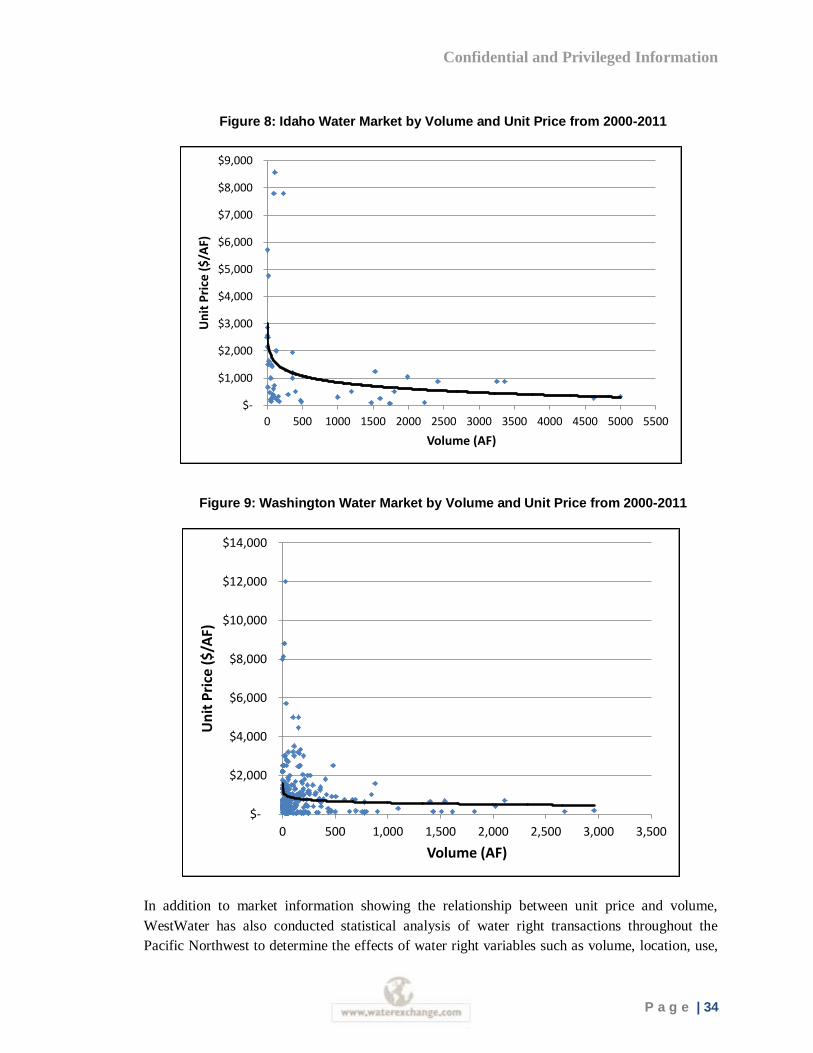
Confidential and Privileged Information
P a g e | 34
Figure 8: Idaho Water Market by Volume and Unit Price from 2000-2011
Figure 9: Washington Water Market by Volume and Unit Price from 2000-2011
In addition to market information showing the relationship between unit price and volume,
WestWater has also conducted statistical analysis of water right transactions throughout the
Pacific Northwest to determine the effects of water right variables such as volume, location, use,
$-
$1,000
$2,000
$3,000
$4,000
$5,000
$6,000
$7,000
$8,000
$9,000
0 500 1000 1500 2000 2500 3000 3500 4000 4500 5000 5500
Un
it P
rice
($
/AF)
Volume (AF)
$-
$2,000
$4,000
$6,000
$8,000
$10,000
$12,000
$14,000
0 500 1,000 1,500 2,000 2,500 3,000 3,500
Un
it P
rice
($
/AF)
Volume (AF)
Confidential and Privileged Information
P a g e | 35
and time on the price. Volume has a negative relationship with price. In fact, a 1 percent
increase in volume leads to a 0.1 percent decrease in the price paid. Comparing the average
volume of the three surface water rights transactions (69 AF) to the maximum estimated
transferable volume of the subject water right (833 AF); the statistical model suggests a 23
percent downward adjustment to unit price in order to account for the large size of the subject
water rights.
Water Right Comparable Sales Summary
Water right changes in the Wood River Basin were reviewed in an effort to identify water right
sales that could be used in support of valuing the subject water rights. A comprehensive review of
IDWR water right transfer records indicated that water right sales activity separate from land has
been very limited in recent years. A limited number of surface and groundwater right
transactions were identified with varying prices. The two groundwater trades represent very small
volumes were the lowest priced transactions ($16,500/Acre) recorded. The highest priced
transaction ($30,000/Acre) involved an 1883 senior surface water right conveyed to the City of
Hailey in lieu of associated development fees. It appears that the price in the transaction was
based primarily upon the negotiated price of a prior sale of the same water right to a real estate
developer.
Real estate development activity has virtually ceased in the basin limiting the demand for senior
surface water rights. As a result, the prior sales of senior surface water rights in the basin are not
considered to be representative of current market conditions. Similarly, the groundwater right
sales involved very small volumes that cannot be easily compared to the subject water right. To
put it in perspective, there would need to be more than 50 individual buyers willing to pay
$16,500 per acre to fully absorb the subject water right in the market. This volume of demand is
not supported through prior sales or market research conducted for this analysis and appears
unlikely to materialize in a mitigation market unless the current transfer limitations are
eliminated. Due to the lack of direct applicability of prior water right sales to the subject water
rights, this analysis considers land values in the region as an alternative valuation approach.
Land Price Differential Approach
This valuation method compares sale prices of agricultural land with water rights to land without
water rights. The differential between the two prices represents the value that can be attributed to
the water right. The method requires information on recent land sales and is typically used by
real estate appraisers conducting water rights appraisals. WestWater Research has found this
approach to be particular reliable in areas with limited water right trading.
Information collected from the Blaine County Assessor’s Office, the multiple listing services
(MLS), and local real estate agents confirmed a wide variety of prices exist throughout the
county. The land prices on actual sales reported by the assessor range from $1,671 to $50,000 per
acre, averaging roughly $16,000 per acre. These reported prices include improvements, if
applicable. The lower end of the range is representative of transactions on the southern portion of
Confidential and Privileged Information
P a g e | 36
the county in agricultural uses with minimal improvements, while the upper bound represents
smaller irrigated acreage associated with large homes, barns, outbuildings, and other
improvements. The majority of the transactions and listings are not comparable to the subject
property due to location (mostly downstream near Bellevue) which limits applicability to the
subject water rights.
Perhaps the most compelling evidence of current value for the subject water rights comes from a
listed property near Hailey. Croy Creek Ranch is comprised of five parcels of agricultural land
located southwest of Hailey. The property is roughly 465 acres and the last listing price was $2.5
million. A listing offering a portion of the property was recently removed from the MLS;
however, the listing agency is currently preparing to list the property in its entirety. The water
rights appurtenant the land includes three partially decreed surface water rights and one
groundwater right. The surface water rights provide for the irrigation of 320 acres. The surface
rights originate from Croy Creek, Bullion Creek, and Unnamed stream all of which are tributary
to the Big Wood River, and have an 1883 priority date. Physical water availability on Croy
Creek and Unnamed stream appears to be substantially less than the allotment allowed on the
paper water right. However, the flows from Bullion Creek are typically sufficient to provide
surface water supply thru late July.19 The groundwater right provides for the irrigation of 222
acres on the same 320 acre surface water place of use. The groundwater right has a 1974 priority
date and is typically utilized from late July thru the end of the irrigation season to supplement low
surface water flows. According to the listing agent, there was a preliminary approval for a 34 lot
subdivision that proposed ample water for the subdivision with 132 acres of 1883 deeded water
rights over and above (combination of stream and ground water rights) that could be used for
another purpose.20 The irrigated acreage associated with Croy Creek Ranch was being offered
for slightly less than $8,000 per acre if all value is attributed to the irrigated acres and no value to
the remaining dryland acres.
While the property has not been sold, the listing price suggests that the current market for land
with senior water rights is well below the prices established by the few recorded water right
transactions in the region.
19 Conversation with Charles Brockway, Brockway Engineering, January, 2012
20 Conversation with Katherine Rixon, Sun Valley Brokers, January 23, 2011
Confidential and Privileged Information
P a g e | 37
Summary and Value Conclusions
This analysis provides a review of the marketability and value for the water rights appurtenant
QCR. The water rights provide for the irrigation of 276.5 acres near Hailey, Idaho. While there
are seven water rights on the property, water right 37-19736, with an 1880 priority date, is the
only water right that can be used for mitigation of junior priority water rights. Furthermore, the
market region for the subject water right is currently defined by the Rohe decision as the City of
Hailey and downstream.
Real estate development activity has slowed considerably in the region. Currently, a number of
senior water rights associated with proposed developments are being leased to the water supply
bank due to stalled development projects. It is not known when development activity will return
to the region. However, under current economic conditions, the demand for senior water rights
by developers appears to be limited.
Senior water rights exposed to a future mitigation market at reasonable prices will likely
experience interest from a limited set of potential buyers. In particular, the subject water right is
well situated to provide mitigation for outdoor water use within the City of Hailey. Downstream
of Hailey, the City of Bellevue indicated that they will not have a need for mitigation under
conjunctive management. Further, there are relatively few, small parcel recreational properties
downstream of Hailey that represent potential mitigation demand.
The future mitigation market is considered the highest and best use of the subject water right and
a sales comparison valuation approach was considered to provide a baseline for valuation. The
water rights market in the Wood River Valley is a small, insulated market with very few market
participants. Prices for the few water trades appear to have been perpetuated by a limited number
of market participants. While there is a perception of high demand and values for senior water
rights in the basin, market research conducted for this analysis suggest that the current demand
for the subject water rights outside of the City of Hailey is limited. Furthermore, it appears that
there are a number of senior water rights located upstream that could potentially serve the same
future mitigation market as the subject water right.
Land sales and listings in the region were considered in order to supplement the limited set of
water right sales. Like the water right market, there have been few sales of land with water rights
in recent years. A majority of the sales have occurred in the Bellevue “triangle” region and are
considered to have limited applicability to the subject water rights. However, a large property
with senior water rights in the vicinity of QCR is currently being marketed. Assuming all the
value in the listing is associated with the water rights, the offer price is equivalent to
approximately $8,000 per acre.
This analysis was significantly constrained by the lack of available market information. Both the
land market and market for water rights has experienced extremely limited trading in recent
years. While a market for senior water rights may emerge as a result of future conjunctive
management, it is not evident that the high prices observed in the limited set of prior water right

Confidential and Privileged Information
P a g e | 38
sales are applicable to the subject water right due to changes in economic conditions and
regulatory constraints affected the transferability and marketability of the subject water right.
Given the available market information, analysis presented in this report, and the appraiser’s
experience, the estimated value range of the subject water right is $8,000 to $12,000 per acre.
The lower end of the range is associated with the Croy Creek property listing. Due to the inferior
seniority and reliability of the senior surface water rights on the Croy Creek property, some
upward adjustment from the lower end of the price range may be warranted. However, given the
limited market information and the uncertainty regarding a future mitigation market, the value is
best expressed as a range. As a result, the current value of the water rights appurtenant the QCR
is estimated to be $2,212,000 ($8,000/Acre x 276.5 irrigated acres) to $3,318,000 ($12,000/Acre
x 276.5 irrigated acres).
Confidential and Privileged Information
P a g e | 39
Appendix A: Water Right File
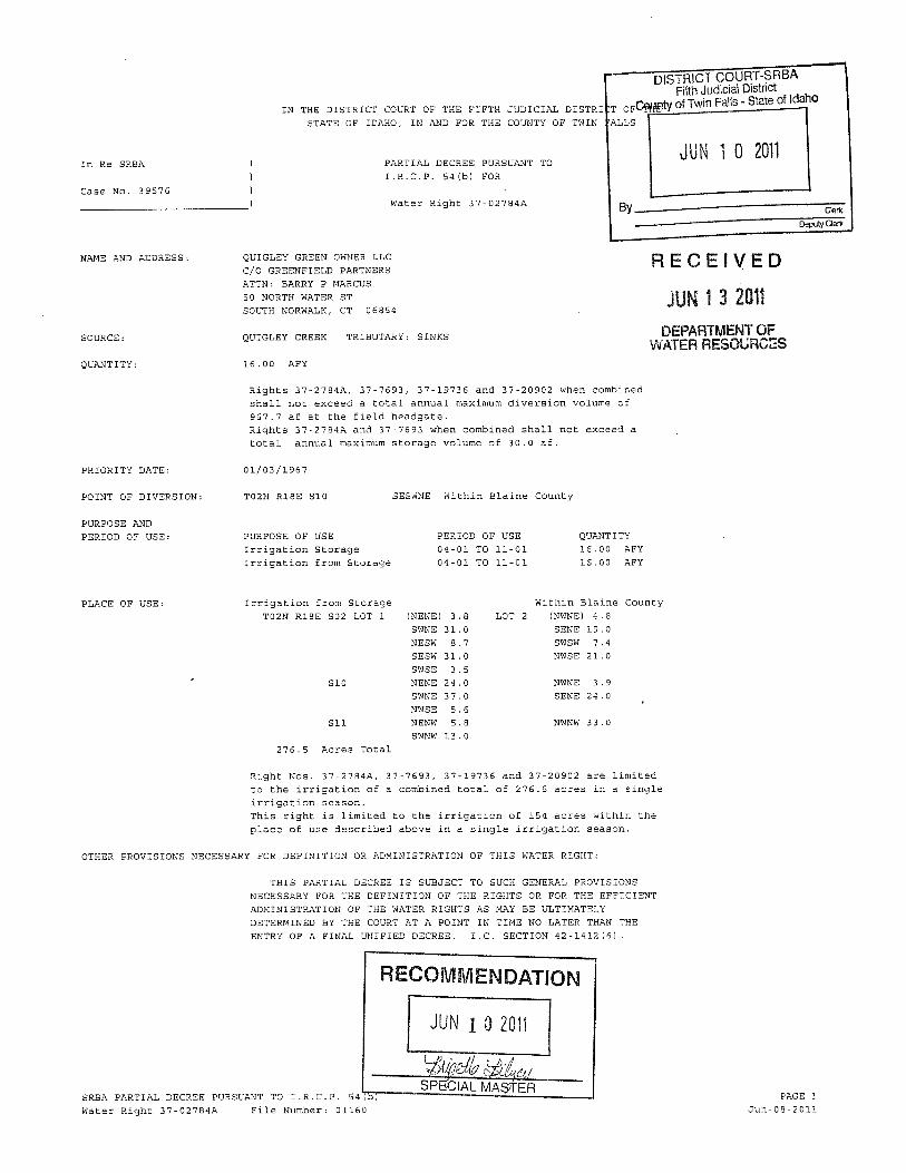
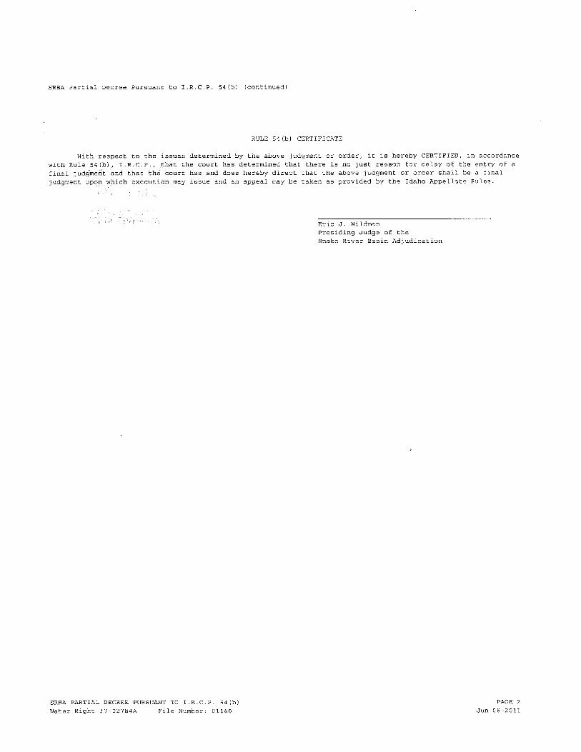
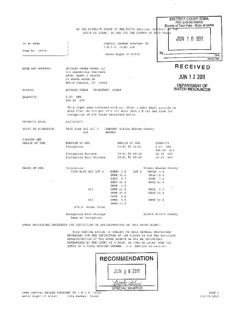
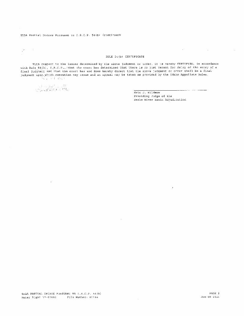
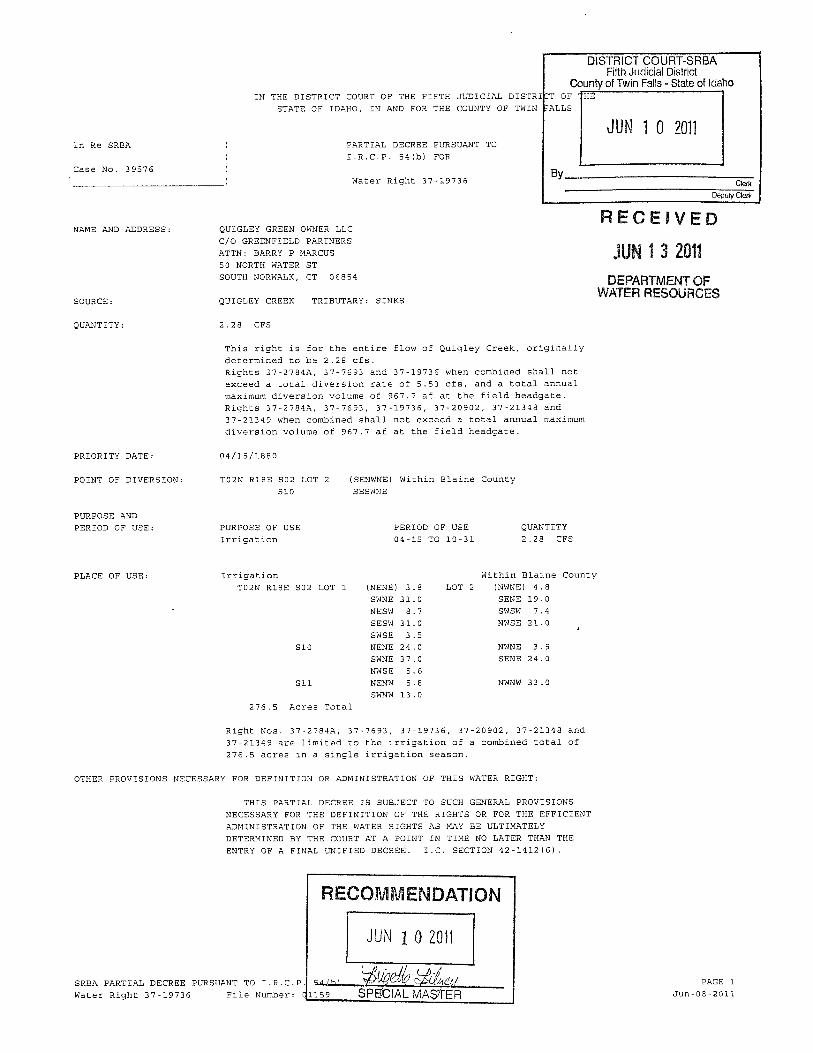
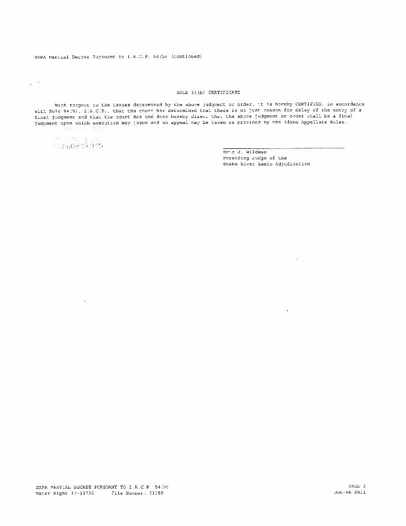
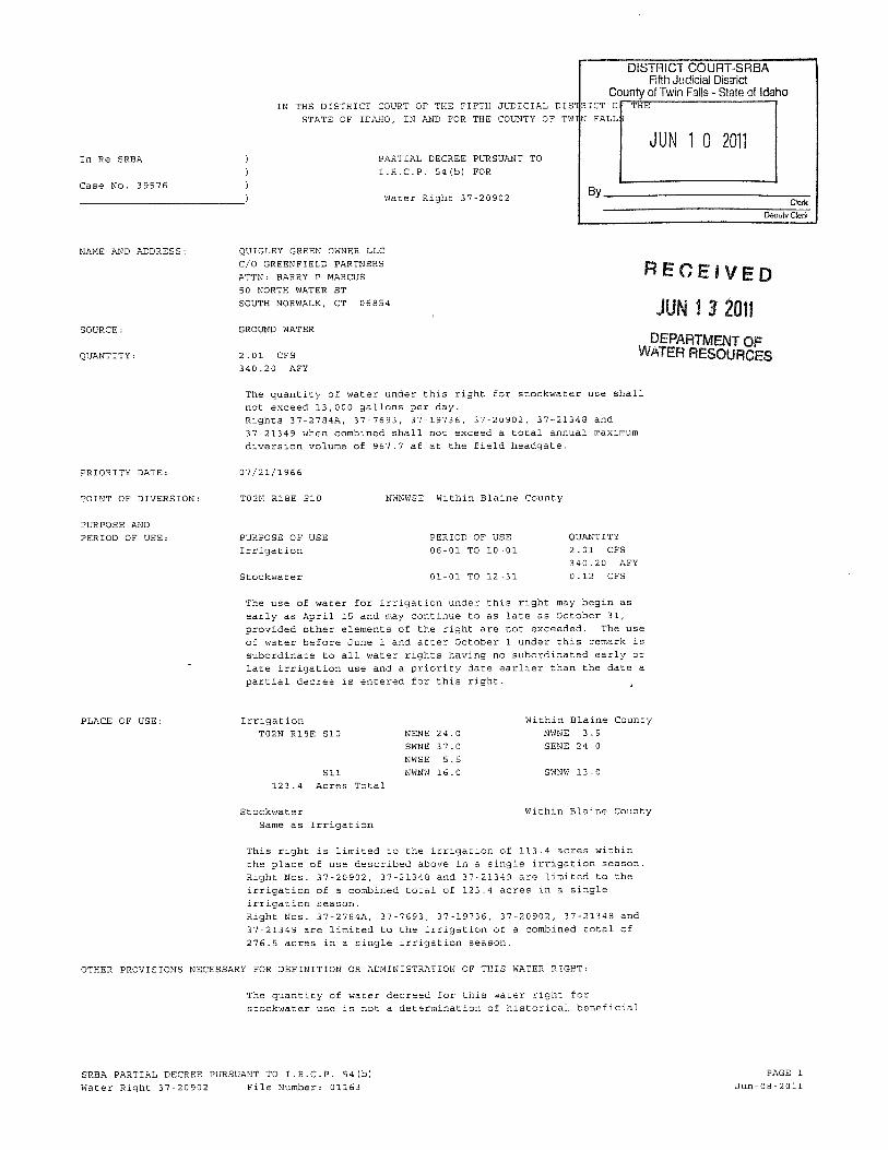
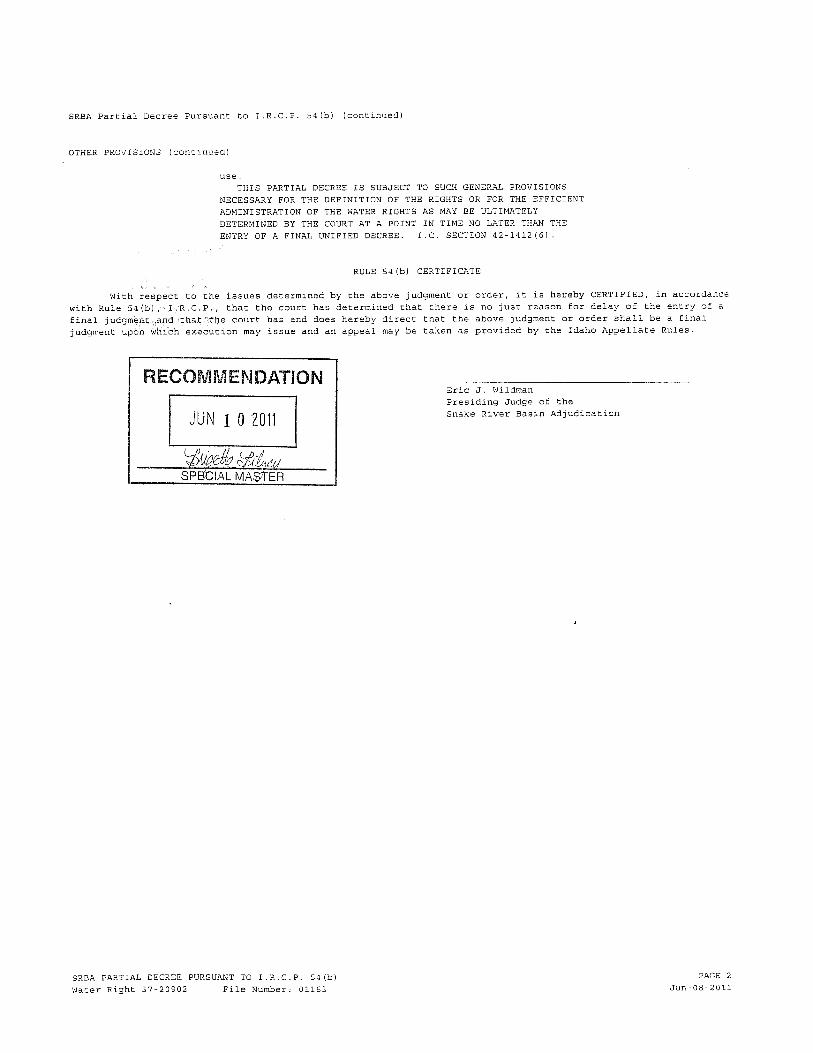
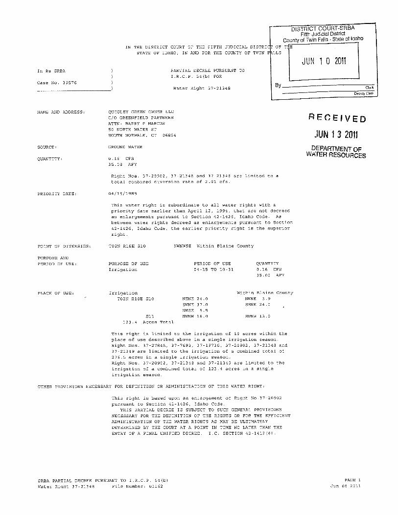
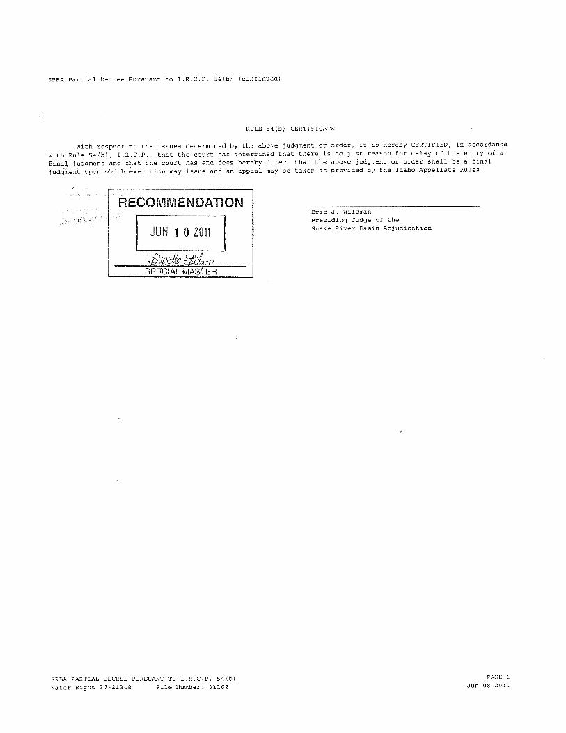
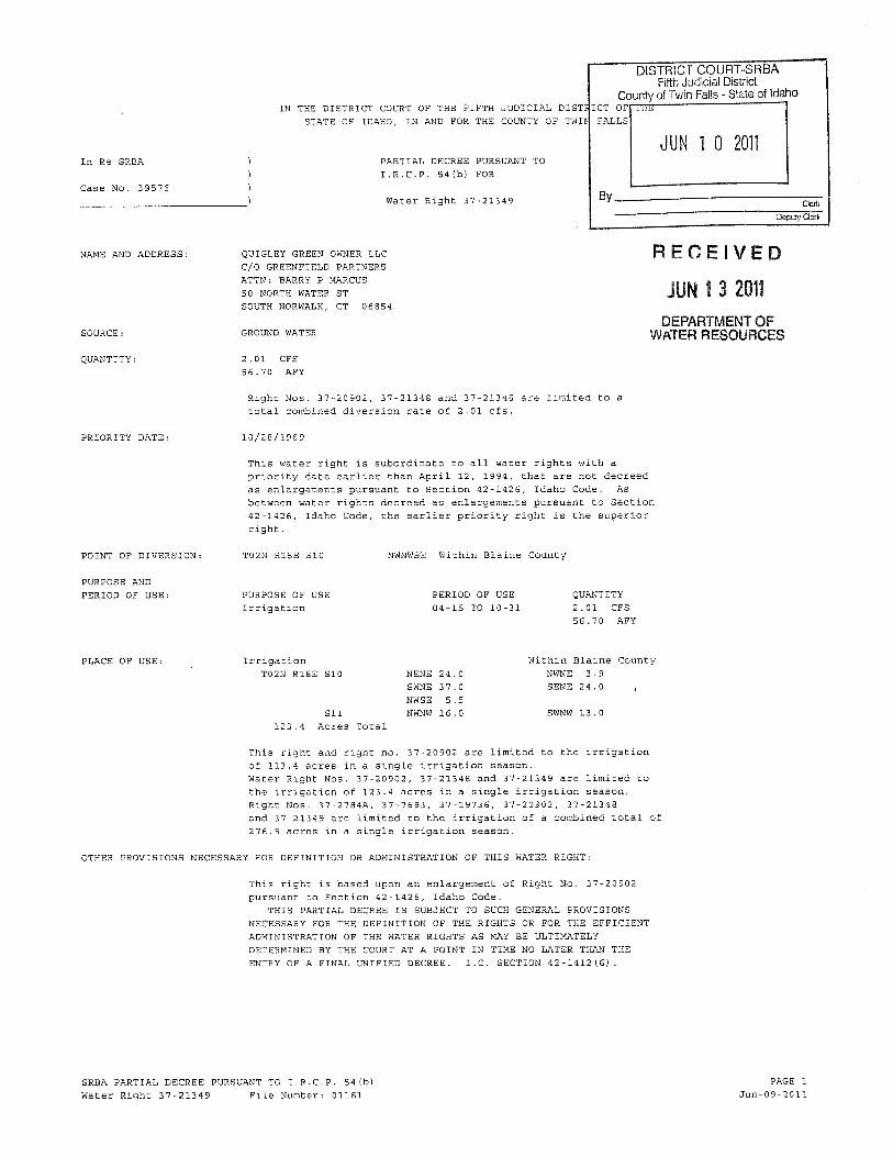
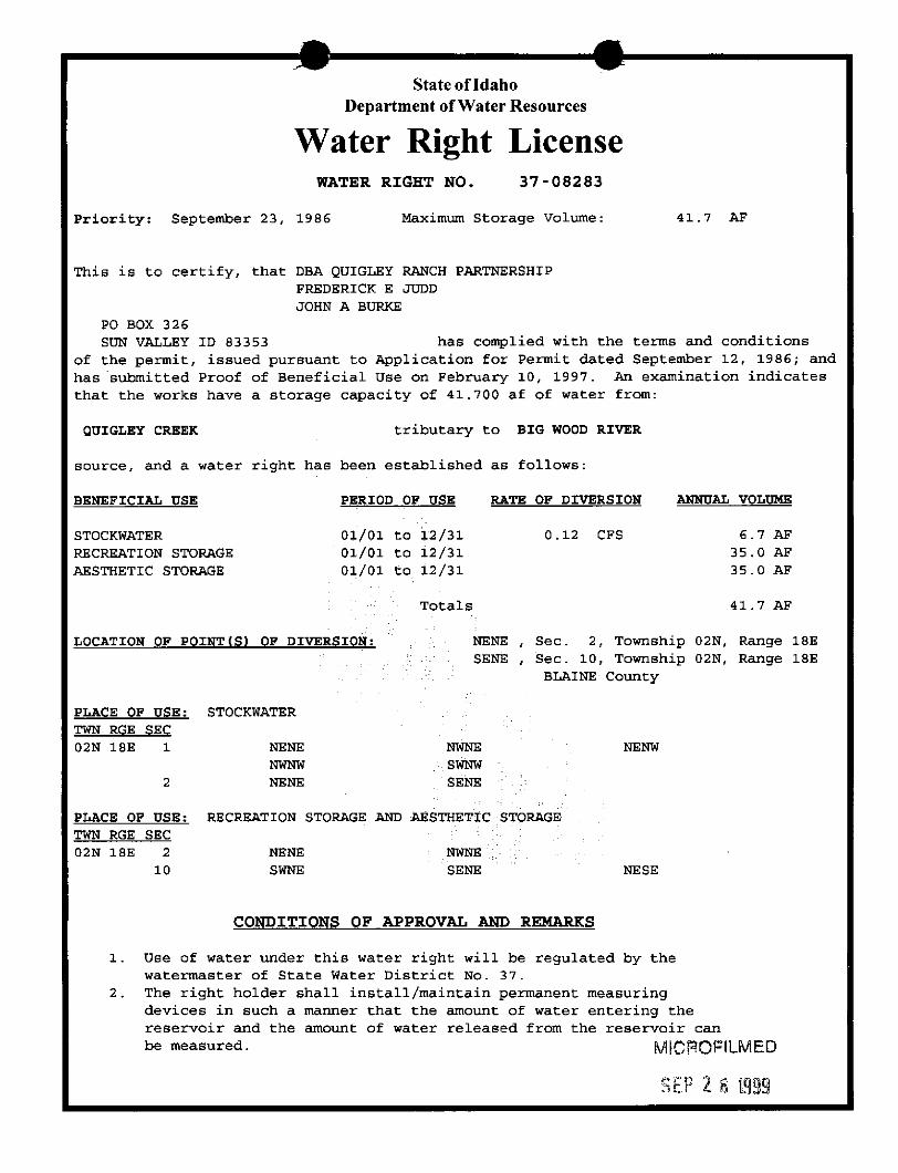
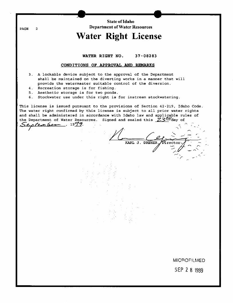

Confidential and Privileged Information
P a g e | 40
Appendix B: Maps
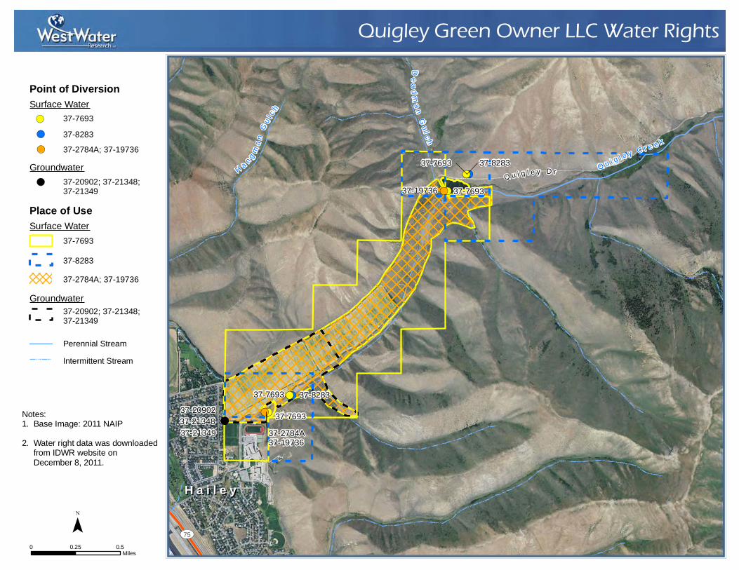
!(!(!(
!(!(
!(!(!(
!(
!(
!(!(
!(!(37-7693
37-7693
37-8283
37-8283
37-7693 37-2784A
37-7693
37-19736
37-19736
37-21349 37-21348 37-20902
UV75
Quigley Green Owner LLC Water Rights
0 0.50.25Miles
¯
Notes:1. Base Image: 2011 NAIP2. Water right data was downloaded from IDWR website on December 8, 2011.
Q u i g l e y C r e e k
H a n g ma n
Gu l c
h
Dead m
a n Gu l c h
H a i l e yH a i l e y
Q u i g l e y D r
Point of DiversionSurface Water
Groundwater
Place of UseSurface Water
Groundwater
!( 37-7693!( 37-8283!( 37-2784A; 37-19736
!( 37-20902; 37-21348; 37-21349
37-20902; 37-21348; 37-21349
Perennial StreamIntermittent Stream
37-769337-828337-2784A; 37-19736
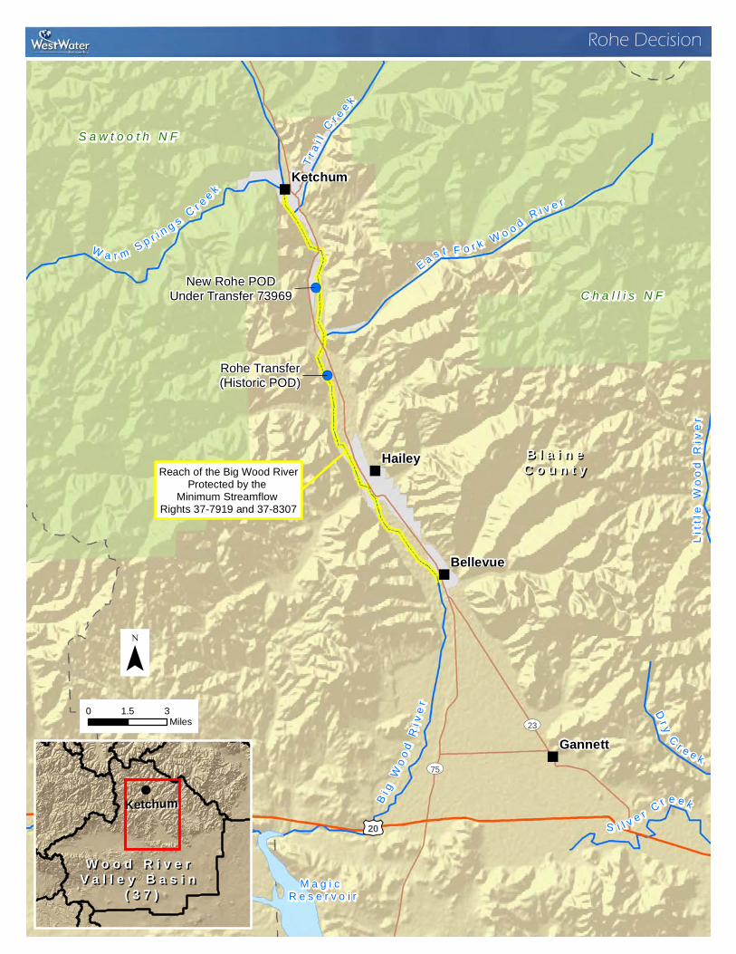
"
"
"
"
!(
!(Rohe Transfer(Historic POD)
New Rohe PODUnder Transfer 73969
B l a i n eB l a i n eC o u n t yC o u n t yHailey
Gannett
Ketchum
Bellevue
£¤20
UV75
UV23
CC aa mm aa ss CC rr ee ee kk
EE aa ss tt FF oo rr kk WW oo oo dd RR ii vv ee rr
TT rr aa ii ll CC rr ee ee kk
WW aa rr mm SS pp rr ii nn gg ss CC rr ee ee kk
DDrryy CC rr ee ee kk
SS ii ll vv ee rr CC rr ee ee kk
Litt
le W
ood
Riv
erLi
ttle
Woo
d R
iver
Rohe Decision
0 31.5Miles
¯
!(
KetchumKetchum
W o o d R i v e r W o o d R i v e r V a l l e y B a s i n V a l l e y B a s i n
( 3 7 )( 3 7 )
Reach of the Big Wood RiverProtected by the
Minimum Streamflow Rights 37-7919 and 37-8307
M a g i c M a g i c R e s e r v o i rR e s e r v o i r
S a w t o o t h N FS a w t o o t h N F
C h a l l i s N FC h a l l i s N F
BB ii gg WW
oo oo dd RRii vv
ee rr
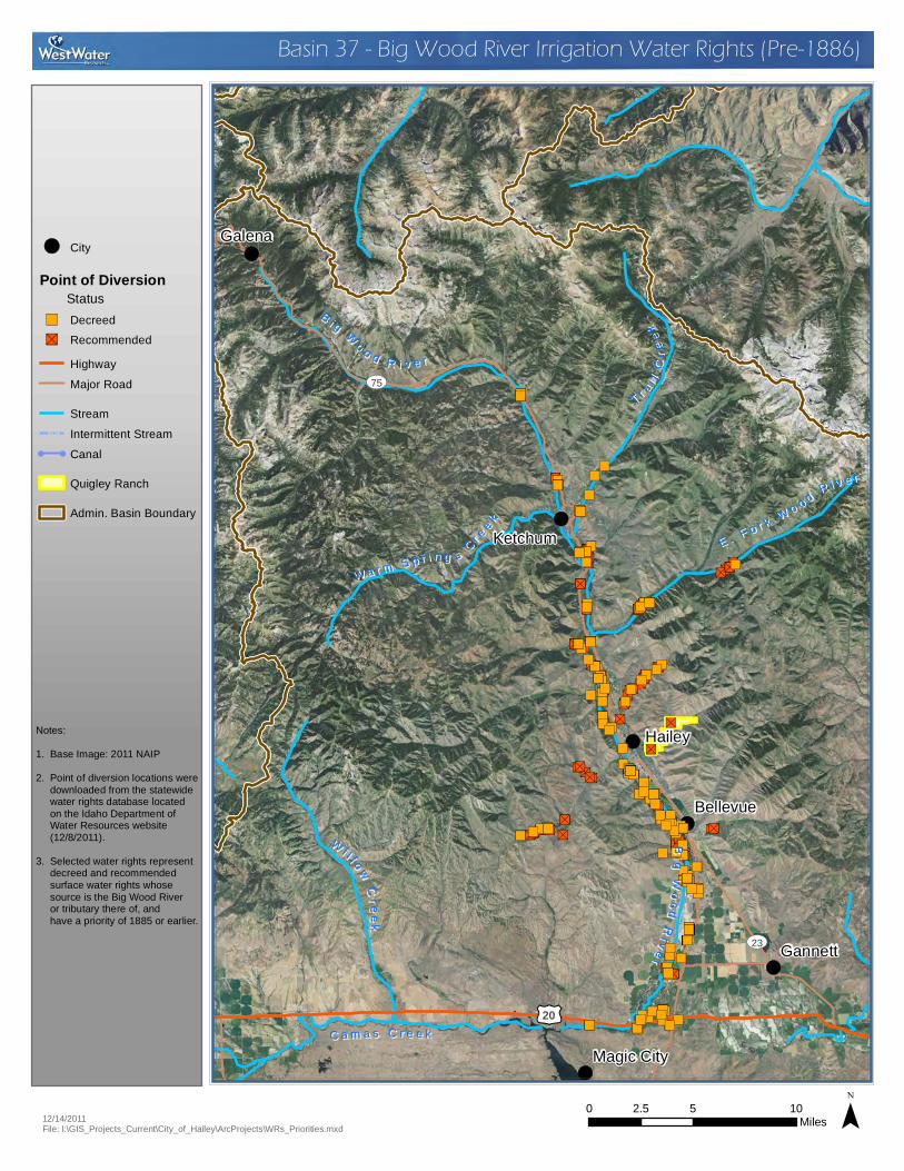
!(
!(
!(
!(
!(
!(
!(
"S
"S"S
"S"S"S
"S
"S
"S
"S"S
"S
"S
"S
"S"S
"S
"S
"S"S
"S"S
"S
"S"S"S"S"S
"S"S"S
"S"S"S"S"S
"S
"S
"S
"S"S
"S
"S
"S
"S
"S
"S
"S
"S
"S
"S"S"S
"S"S"S"S"S
"S"S"S
"S
"S
"S"S
"S
"S
"S"S"S
"S
"S
"S
"S"S"S
"S
"S
"S"S"S"S"S"S"S"S"S"S"S"S"S"S
"S"S
"S
"S
"S"S"S"S"S"S"S"S"S
"S
"S
"S
"S
"S"S
"S"S
"S
"S
"S"S
"S
"S"S
"S
"S"S"S
"S"S"S
"S"S
"S"S"S"S"S"S"S
"S
"S
"S
"S
"S
"S"S
"S
"S
"S
"S
"S
"S
"S
"S"S
"S
"S"S"S
"S
"S
"S
"S"S
"S
"S"S
"S
"S
"S
"S
"S
"S
"S
"S
"S
"S"S"S
"S
"S
"S
"S
"S
"S"S"S"S
"S"S
"S
"S
"S"S"S
"S
"S"S
"S
"S"S"S
"S
"S"S
"S
"S
"S
"S"S
"S
"S"S"S"S"S"S"S"S"S"S"S"S"S"S"S"S"S"S"S"S"S"S"S"S"S"S"S
"S
"S
"S"S"S"S"S"S"S
"S
"S"S
"S"S
"S
"S"S
"S
"S
"S
"S"S
"S"S
"S
"S"S
"S
"S
"S
"S
"S"S
"S
"S
"S
"S"S"S
"S"S
"S
"S
"S
"S"S"S
"S
"S
"S
"S
"S
"S
"S
"S"S
"S
"S
"S
"S"S
"S
"S
"S
"S
"S
"S
"S"S
"S"S
"S
"S"S
"S"S"S"S
"S
"S
"S
"S"S
"S
"S"S
"S
"S
"S"S
"S"S
"S"S
"S"S
"S
"S"S"S"S"S"S"S"S"S"S"S"S"S"S"S
"S"S"S
"S"S
"S
"S"S"S"S"S"S"S"S"S"S"S"S"S
"S
"S
"S
"S"S
"S
"S"S"S
"S"S
"S
"S
"S
"S"S
"S"S
"S
"S"S"S"S"S"S"S
"S
"S"S
"S
"S
"S
"S
"S
"S
"S
"S
"S"S
"S"S"S
"S
"S"S"S
"S"S
"S
"S
"S
"S
"S
"S
"S
"S
"S
"S
"S
"S
"S
"S
"S
"S
"S
"S
"S
"S
"S"S
"S
"S
"S"S"S"S"S"S
"S"S
"S
"S"S
"S
"S"S"S"S
"S
"S"S
"S
"S
"S"S"S"S"S"S"S"S"S"S
"S"S
"S"S
"S
"S
"S"S"S"S"S"S"S"S"S"S"S"S"S"S
"S"S"S"S"S"S"S"S"S
"S"S
"S
"S"S"S"S
"S"S"S"S"S"S"S"S"S"S
"S
"S
"S"S"S"S
"S
"S"S
"S
"S
"S
"S"S
"S
"S"S"S
"S"S"S"S"S"S"S"S"S"S"S"S"S"S
"S"S"S"S"S"S"S"S
"S"S"S
"S "S"S"S"S"S"S "S"S"S"S
"S"S"S"S
"S
"S
"S"S"S
"S"S
"S"S"S"S
"S"S"S
"S"S
"S
"S"S
"S
"S
"S"S"S
"S"S
"S
"S"S"S"S"S"S
"S"S"S
"S"S
"S"S
"S"S"S"S"S"S
"S"S
"S
")")
")
")
")")")")
")")
")")
")
")")")")")")
")
")")")
")")
")")")
")
")
")
")
")
")")
")")")
")")
")
")
")
")
")
")
")")
")")
")
")")")")")")
")
")
")")
")
")
")")
")
")
")
")")
")")
")
")
")")
")
")
")")")")
")
")
")")
")")")")")
")")
")
")
")")")
")")")")
")
")")
")
")
")
")
")")
")
")
")")
")
")
")
")
")
")
")
")
")
")
")
")")
")")
")
")
")
")
")
")
")
")
")
")
")
")
")
")")
")
")
")
")
")")
")
")
")")")
")")
")")
")")")
")")
")
")
")")
")
")")
")
")
")
")")
")")
")")")
")
")")
")
")
")")")")
")")")")
")
")")
")")")")")")
")")
")")
")")
")
")
")")
")
")
")")
")")")
")")
")")
")")
")
")")")")")")")")")
")
")")
")
")
")
")")")")")")
")")")")
")
")")
")")")")")
")
")")
")")
")")
")")")
")
")")")")")")")")")")")
")")")")
")")
")")
")
")
")
")")
")
")")")")")")
")
")")")")")")")")
")
")")
")
")")")")
")")")
")")
")")
")
")
")
")")
")")")")")")")")")")")")")")")")")")")")")")")")")")")")")")")")")")")")")")")")")")")")")")")")")")")")")")")")")")")
")
")
")
")
")
")
")")")")")
")
")")
")")")")
")
")
")")
")")
")")")")")")")")")")")")")")")
")
")
")
")")
")
")")")")")")
")
")")
")")")
")")")
")
")")")
")
")
")
")")")")")")")")")")")")")")")")")")")")")
")
")")
Picabo
Hailey
Galena
GannettSoldier
Ketchum
Bellevue
Fairfield
Magic City£¤20
UV75
UV23
Basin 37 - Big Wood River Irrigation Water Rights (Pre-1886)
0 5 102.5Miles ¯12/14/2011
File: I:\GIS_Projects_Current\City_of_Hailey\ArcProjects\WRs_Priorities.mxd
Notes:1. Base Image: 2011 NAIP2. Point of diversion locations were downloaded from the statewide water rights database located on the Idaho Department of Water Resources website (12/8/2011). 3. Selected water rights represent decreed and recommended surface water rights whose source is the Big Wood River or tributary there of, and have a priority of 1885 or earlier.
BB ii gg WW oo oo dd RR ii vv ee rr
TT rr aa ii ll CC
rreeeekk
WW ii ll ll oo ww CCr re ee ek k
CC aa mm aa ss CC rr ee ee kk
WW aa rr mm SS pp rr ii nn gg ss CC rr ee ee kk
EE .. FF oo rr kk WW oo oo dd RR ii vv ee rr
B Bi ig g WWo oo odd RRi ivveerr
HighwayMajor Road
StreamIntermittent Stream
! ! Canal
Quigley Ranch
Admin. Basin Boundary
!( City
Point of DiversionStatusDecreed")
Recommended"S
Top Related