


Languages
Pages
Legal

Platform Data Extension PDE 1.4Technical Training
http://pde.api.here.com/

22
What is PDE?
• Online access to core map data• For Platform business customers• All attribution (slopes, road type…) on top of the Platform attributes (speed,
func.class)• Thematic layers, geographically tiled, simple text or JSON format
• Platform customers don’t need to download + install RDF• … don’t need to compile into a binary format• … don’t need a hosting service / cloud• … devices / browsers don’t need complex PSF access libraries
33
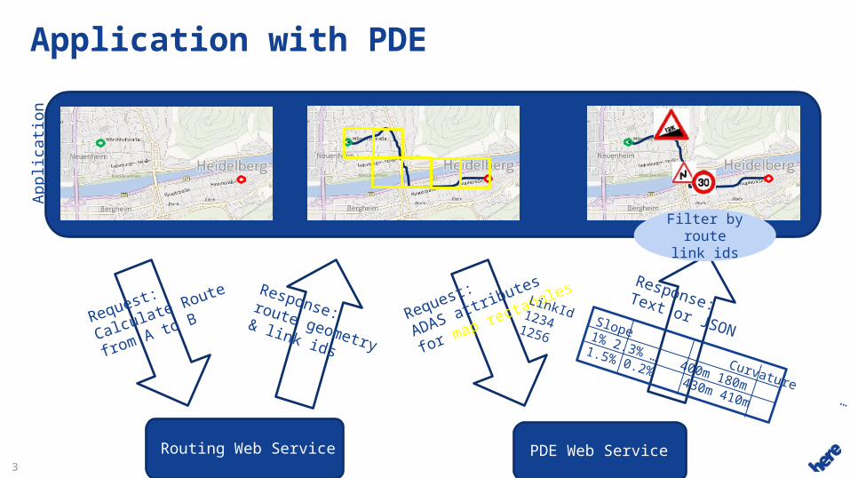
Application with PDEA
pp
licati
on
PDE Web Service
Request:
ADAS attributes
for map rectangles
Response:Text or JSONLinkId Slope Curvature …
1234 1% 2.3% … 400m 180m
1256 1.5% 0.2% 430m 410m
Routing Web Service
Request:
Calculate Route
from A to B
Response:route geometry& link ids
Filter by route link
ids
44
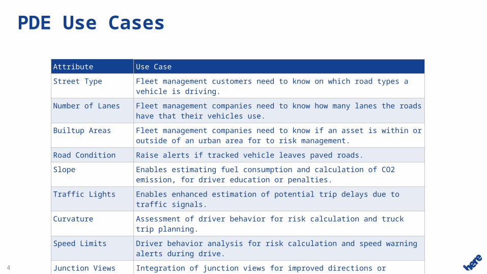
PDE Use Cases
Attribute Use Case
Street Type Fleet management customers need to know on which road types a vehicle is driving.
Number of Lanes Fleet management companies need to know how many lanes the roads have that their vehicles use.
Builtup Areas Fleet management companies need to know if an asset is within or outside of an urban area for to risk management.
Road Condition Raise alerts if tracked vehicle leaves paved roads.
Slope Enables estimating fuel consumption and calculation of CO2 emission, for driver education or penalties.
Traffic Lights Enables enhanced estimation of potential trip delays due to traffic signals.
Curvature Assessment of driver behavior for risk calculation and truck trip planning.
Speed Limits Driver behavior analysis for risk calculation and speed warning alerts during drive.
Junction Views Integration of junction views for improved directions or guidance.
Toll Cost More accurate toll cost estimation for vehicle types based on toll roads and distances, on top of the info returned by the routing service.
55
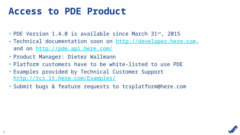
Access to PDE Product
• PDE Version 1.4.0 is available since March 31st, 2015• Technical documentation soon on http://developer.here.com,
and on http://pde.api.here.com/• Product Manager: Dieter Wallmann• Platform customers have to be white-listed to use PDE• Examples provided by Technical Customer Support
http://tcs.it.here.com/Examples/• Submit bugs & feature requests to [email protected]
66
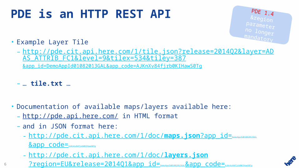
PDE is an HTTP REST API
• Example Layer Tile– http://pde.cit.api.here.com/1/tile.json?release=2014Q2&layer=ADAS_ATTRI
B_FC1&level=9&tilex=534&tiley=387&app_id=DemoAppId01082013GAL&app_code=AJKnXv84fjrb0KIHawS0Tg
– … tile.txt …
• Documentation of available maps/layers available here: – http://pde.api.here.com/ in HTML format– and in JSON format here:
- http://pde.cit.api.here.com/1/doc/maps.json?app_id=DemoAppId01082013GAL
&app_code=AJKnXv84fjrb0KIHawS0Tg
- http://pde.cit.api.here.com/1/doc/layers.json?region=EU&release=2014Q1&app_id=DemoAppId01082013GAL&app_code=AJKnXv84fjrb0KIHawS0Tg
PDE 1.4®ion parameterno longer mandatory

77
PDE Concepts• Layers
– Thematically (driver alert, ADAS, road conditions, …)– Potentially all core map content + additional content (Digital Terrain Model,
…)
• Tiling & Levels– NDS compatible, WGS84 (not QuadKey), Platform compatible– Layers usually distributed into 5 levels (per functional class)
even for long routes need only load ~20 tiles
• IDs from Core Map (Link PVID, Carto PVID, Condition PVID…)– All map releases available fits to current Platform releases
• Binary content also available via file download– e.g. Junction View images
Level 0
y=0, x=0 0,1
Level 1
0,0 0,1 0,30,2
1,0 1,1 1,31,2
Level 2
0,0 0,1 0,30,2
1,0 1,1 1,31,2
2,0 2,1 2,32,2
3,0 3,1 3,33,2
0,4 0,5 0,70,6
1,4 1,5 1,71,6
2,4 2,5 2,72,6
3,4 3,5 3,73,6
0,0 0,1
1,01,1
0,0 0,1
2,32,2
2,1
3,2
1,2 1,31,1
88
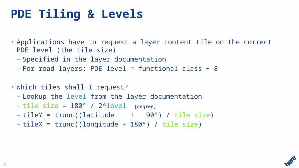
PDE Tiling & Levels
• Applications have to request a layer content tile on the correct PDE level (the tile size)– Specified in the layer documentation– For road layers: PDE level = functional class + 8
• Which tiles shall I request?– Lookup the level from the layer documentation– tile size = 180° / 2^level [degree]
– tileY = trunc((latitude + 90°) / tile size)– tileX = trunc((longitude + 180°) / tile size)
99
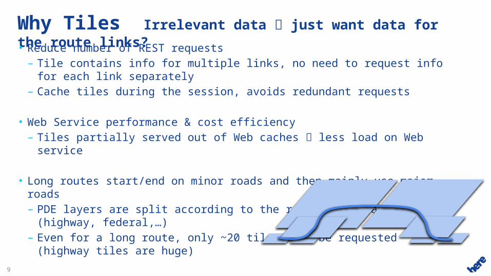
Why Tiles Irrelevant data just want data for the route links?• Reduce number of REST requests
– Tile contains info for multiple links, no need to request info for each link separately
– Cache tiles during the session, avoids redundant requests
• Web Service performance & cost efficiency– Tiles partially served out of Web caches less load on Web service
• Long routes start/end on minor roads and then mainly use major roads– PDE layers are split according to the road functional classes (highway,
federal,…)– Even for a long route, only ~20 tiles must be requested (highway tiles are
huge)
• Serve multiple use cases– Not only “link attributes along route”– E.g. show info for the current map display area, or selected administrative
areas
1010
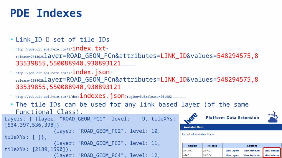
PDE Indexes
• Link_ID set of tile IDs• http://pde.cit.api.here.com/1/index.txt?
release=2014Q2&layer=ROAD_GEOM_FCn&attributes=LINK_ID&values=548294575,833539855,550088940,930893121 &app_id=dIqjg3N5LuHG1QAwHbwD&app_code=rJbZNQB3EN3oB4NqHaFXTQ
• http://pde.cit.api.here.com/1/index.json?
release=2014Q2&layer=ROAD_GEOM_FCn&attributes=LINK_ID&values=548294575,833539855,550088940,930893121 &app_id=dIqjg3N5LuHG1QAwHbwD&app_code=rJbZNQB3EN3oB4NqHaFXTQ
• http://pde.cit.api.here.com/1/doc/indexes.json?region=EU&release=2014Q2 &app_id=dIqjg3N5LuHG1QAwHbwD&app_code=rJbZNQB3EN3oB4NqHaFXTQ
• The tile IDs can be used for any link based layer (of the same Functional Class),e.g. LINK_ATTRIBUTE layer
• Example response:
Layers: [ {layer: "ROAD_GEOM_FC1", level: 9, tileXYs: [534,397,536,398]}, {layer: "ROAD_GEOM_FC2", level: 10, tileXYs: [ ]}, {layer: "ROAD_GEOM_FC3", level: 11, tileXYs: [2139,1590]}, {layer: "ROAD_GEOM_FC4", level: 12, tileXYs: [ ]}, {layer: "ROAD_GEOM_FC5", level: 13, tileXYs: [8580,6376]} ]
1111
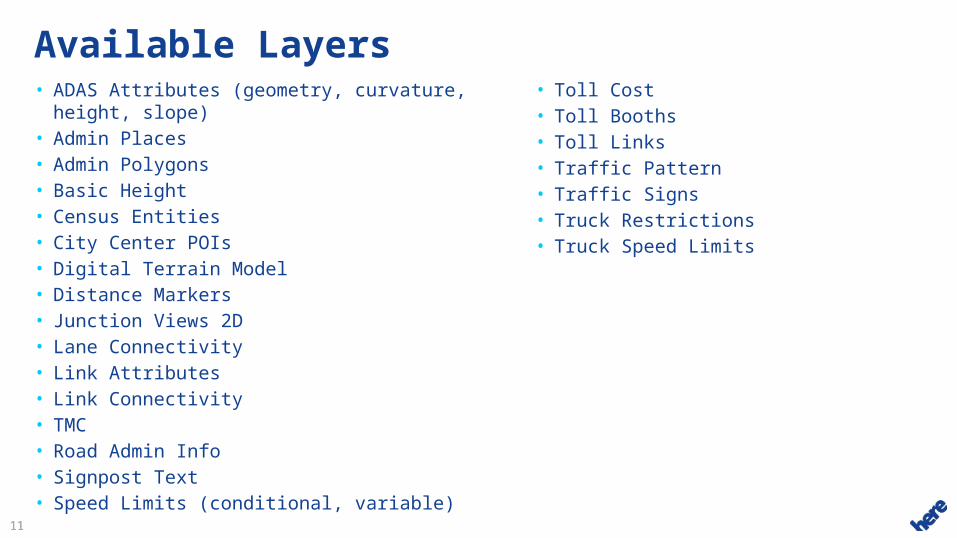
Available Layers• ADAS Attributes (geometry, curvature, height,
slope)• Admin Places• Admin Polygons• Basic Height• Census Entities• City Center POIs• Digital Terrain Model• Distance Markers• Junction Views 2D• Lane Connectivity• Link Attributes• Link Connectivity• TMC• Road Admin Info• Signpost Text• Speed Limits (conditional, variable)
• Toll Cost• Toll Booths• Toll Links• Traffic Pattern• Traffic Signs• Truck Restrictions• Truck Speed Limits

1212
Demo – Digital Terrain Model• http://tcs.it.here.com/Examples/src/HLP3_PDE_DigitalTerrainModel.html

1313
Demo – Distance Markers• http://tcs.it.here.com/Examples/src/HLP3_PDEDistanceMarkers.html

1414
Demo – Junction Views 2D• http://tcs.it.here.com/Examples/src/HLP3_PDEJunctionViewAlongRoute.html
1515
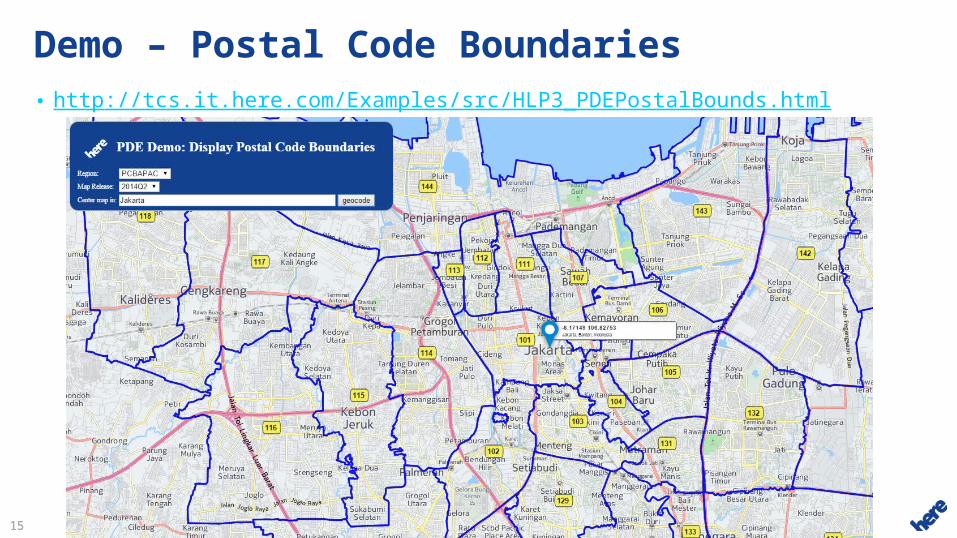
Demo – Postal Code Boundaries• http://tcs.it.here.com/Examples/src/HLP3_PDEPostalBounds.html
1616
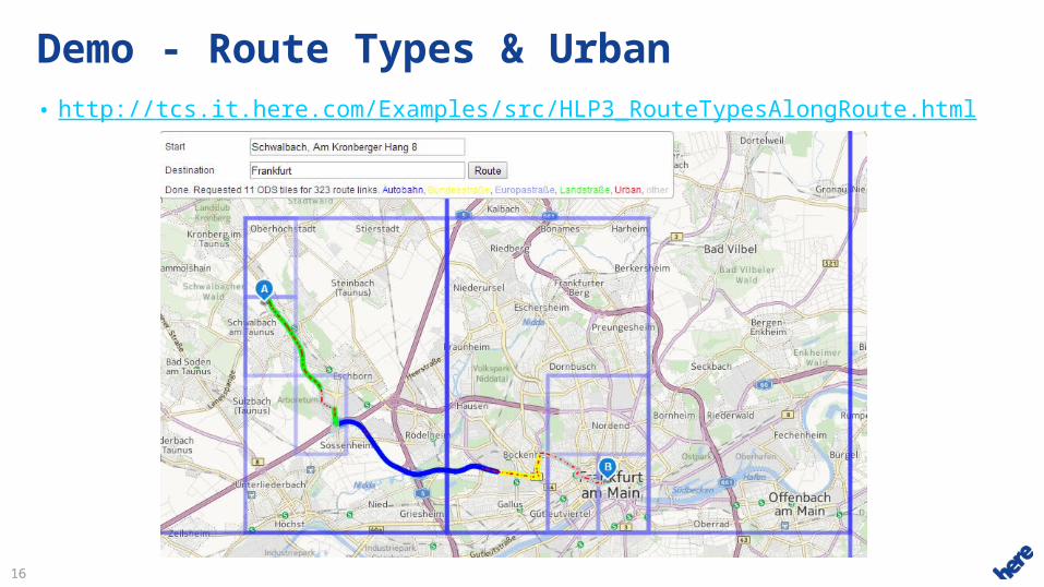
Demo - Route Types & Urban• http://tcs.it.here.com/Examples/src/HLP3_RouteTypesAlongRoute.html
1717
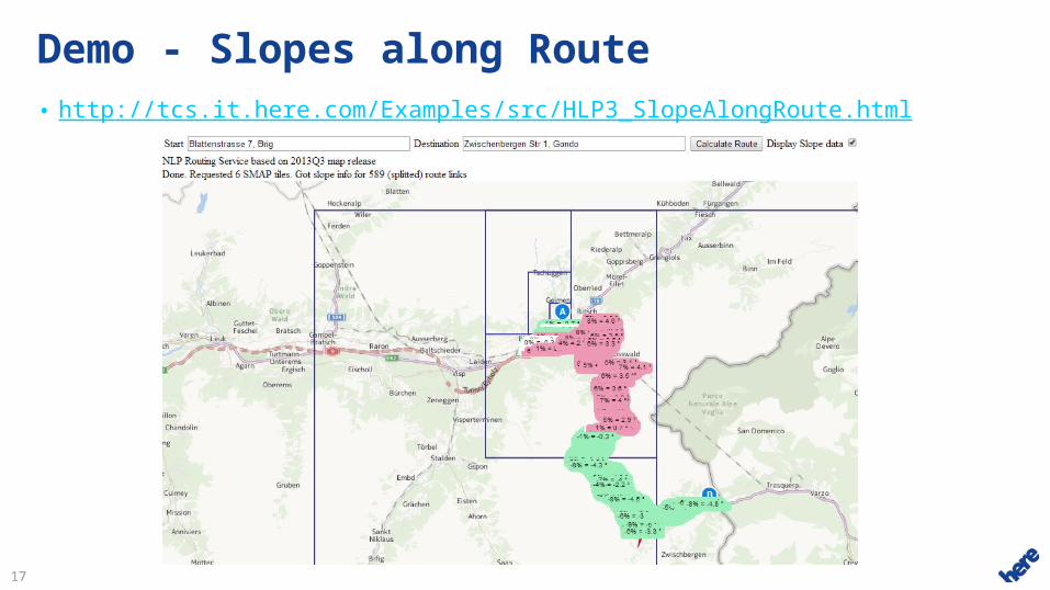
Demo - Slopes along Route• http://tcs.it.here.com/Examples/src/HLP3_SlopeAlongRoute.html
1818
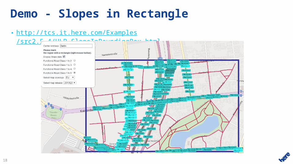
Demo - Slopes in Rectangle
• http://tcs.it.here.com/Examples/src2.5.4/HLP_SlopeInBoundingBox.html
1919
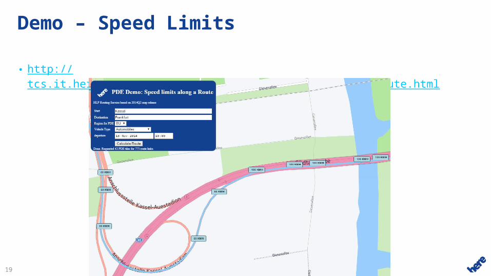
Demo – Speed Limits
• http://tcs.it.here.com/Examples/src/HLP3_PDESpeedLimitsAlongRoute.html
2020
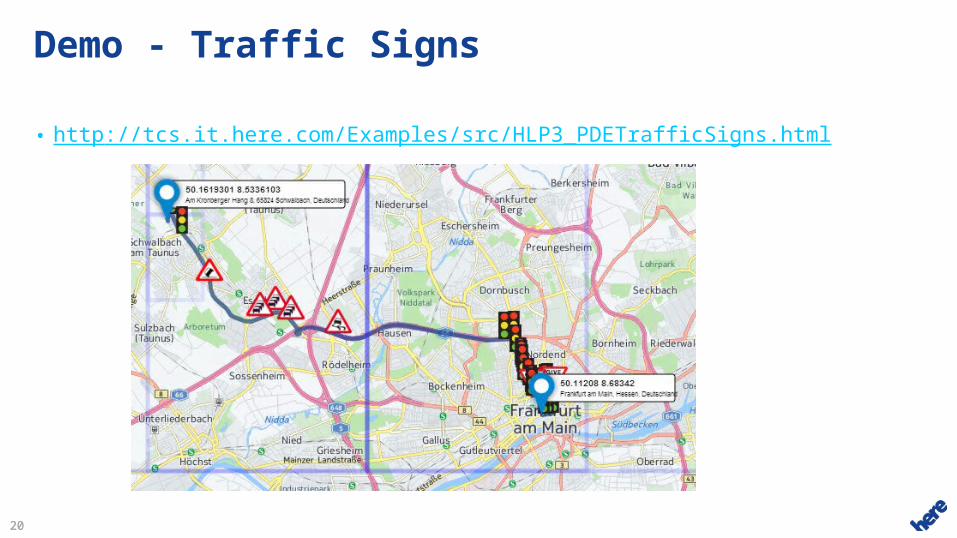
Demo - Traffic Signs
• http://tcs.it.here.com/Examples/src/HLP3_PDETrafficSigns.html
2121
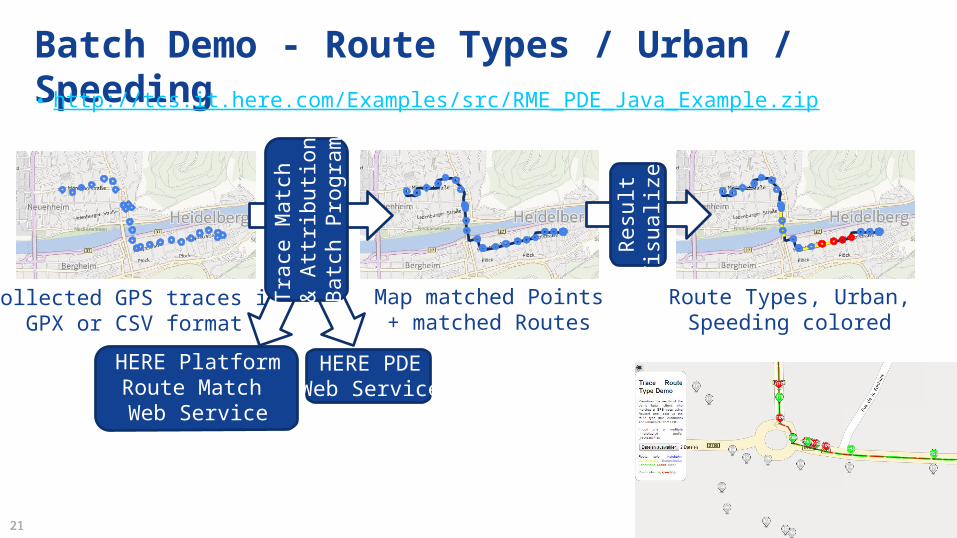
Batch Demo - Route Types / Urban / Speeding• http://tcs.it.here.com/Examples/src/RME_PDE_Java_Example.zip
Collected GPS traces inGPX or CSV format
HERE PDEWeb Service
HERE PlatformRoute Match Web Service
Tra
ce M
atch
& A
ttrib
utio
nB
atch
Pro
gram
Map matched Points+ matched Routes
Route Types, Urban,Speeding colored
Res
ult
Vis
ualiz
er
Top Related