


Languages
Pages
Legal

11
With Acknowledgement to:
2
OutlineGeospatially-enabled Battle Command
• What is the Challenge?
• Why Is It Desirable?
• How Is It Feasible?
• Meeting Key Challenges
• What Does This Mean For Operations?
• Where Is It In Operation?
• What Are the Implications?
ESRI 2008
33
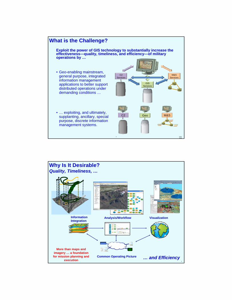
• Geo-enabling mainstream, general purpose, integrated information management applications to better support distributed operations under demanding conditions …
• … exploiting, and ultimately, supplanting, ancillary, special purpose, discrete information management systems.
C2 M&SGeo
C2 Services
M&S Services
GIS Services
What is the Challenge?Exploit the power of GIS technology to substantially increase the effectiveness—quality, timeliness, and efficiency—of military operations by …
4
Why Is It Desirable?Quality, Timeliness, …
Visualization
… and Efficiency
Information Integration
Common Operating Picture
Analysis/Workflow
More than maps and imagery … a foundation for mission planning and
execution
5
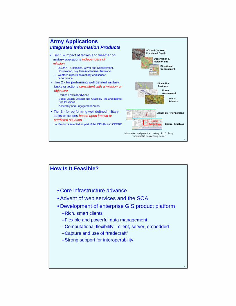
Army ApplicationsIntegrated Information Products• Tier 1 – impact of terrain and weather on
military operations independent of mission
– OCOKA – Obstacles, Cover and Concealment, Observation, Key terrain Maneuver Networks
– Weather impacts on mobility and sensor performance
Off- and On-RoadConnected Graph
Observation &Fields of Fire
DirectionalConcealment
• Tier 2 - for performing well defined military tasks or actions consistent with a mission or objective
– Routes / Axis of Advance– Battle, Attack, Assault and Attack by Fire and Indirect
Fire Positions– Assembly and Engagement Areas
• Tier 3 - for performing well defined military tasks or actions based upon known or predicted situation
– Products selected as part of the OPLAN and OPORD
!.
!.
Direct FirePositions
RouteAssessment
Axis ofAdvance
Attack By Fire Positions
Control Graphics2525B
Symbology
Information and graphics courtesy of U.S. Army Topographic Engineering Center
6
How Is It Feasible?
• Core infrastructure advance• Advent of web services and the SOA• Development of enterprise GIS product platform
–Rich, smart clients–Flexible and powerful data management–Computational flexibility—client, server, embedded–Capture and use of “tradecraft”–Strong support for interoperability
7
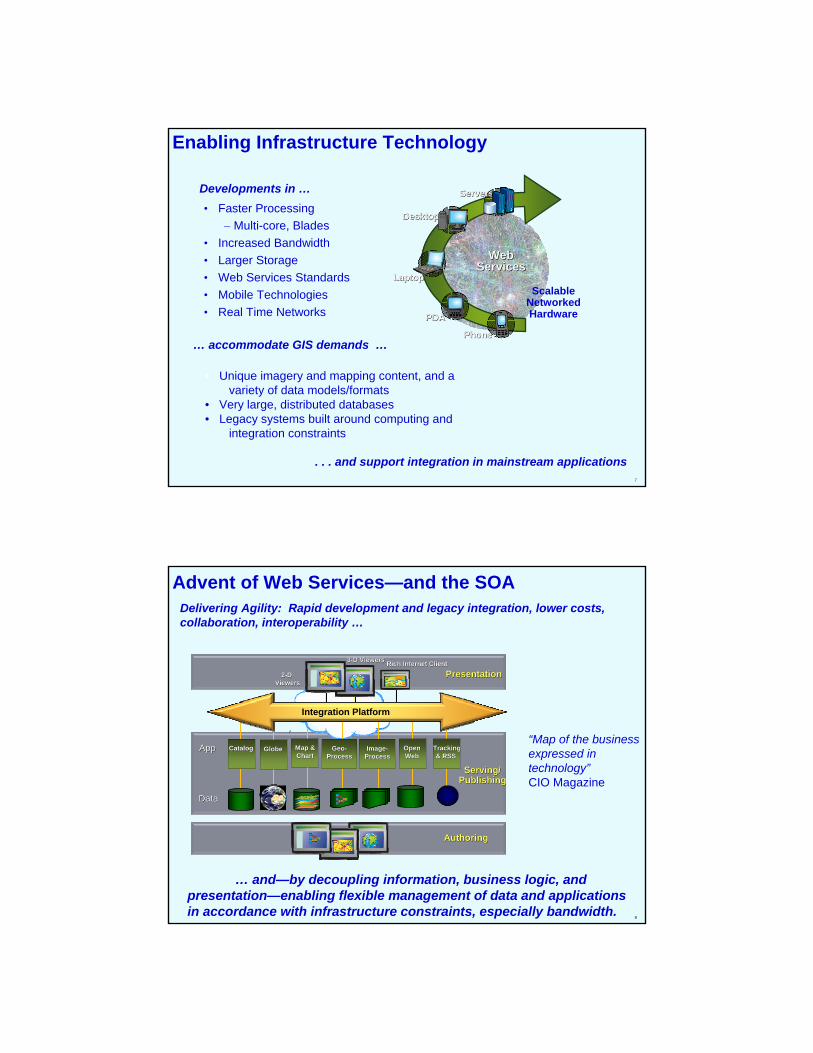
ScalableNetworkedHardware
LaptopLaptop
DesktopDesktop
PDAPDA
ServersServers
PhonePhone
WebWebServicesServices
Enabling Infrastructure Technology
. . . and support integration in mainstream applications
• Faster Processing– Multi-core, Blades
• Increased Bandwidth• Larger Storage• Web Services Standards• Mobile Technologies• Real Time Networks
• Unique imagery and mapping content, and a variety of data models/formats
• Very large, distributed databases• Legacy systems built around computing and
integration constraints
Developments in …
… accommodate GIS demands …
8
Advent of Web Services—and the SOA
… and—by decoupling information, business logic, and presentation—enabling flexible management of data and applications in accordance with infrastructure constraints, especially bandwidth.
Delivering Agility: Rapid development and legacy integration, lower costs, collaboration, interoperability …
“Map of the business expressed in technology”CIO Magazine
PresentationPresentation
Globe Globe Map &Map &ChartChart
ImageImage--ProcessProcess
Open Open Web Web
TrackingTracking& RSS & RSS
Serving/Serving/PublishingPublishing
AuthoringAuthoring
22--D D ViewersViewers
33--D ViewersD Viewers
Catalog Catalog GeoGeo--ProcessProcess
Integration Platform
Rich Internet ClientRich Internet Client
AppApp
DataData

9
Advancing GIS TechnologyIntegrated Platform ...
. . . enabling Enterprise GIS
MobileMobileWebWeb
GDB
DesktopDesktop
ArcGIS Server
OpenOpenAPIsAPIs
OGCOGC
KMLKML
SOAPSOAPSQLSQL
Tracking ServerImage Server
ArcSDEArcIMS ArcGIS Engine
On the Desktop, Server, or Embedded
Google Earth
MetadataISO 19139
KML
CAD
ImageIntegration
SOAP, XML, SQLGIS
Services
AutoCAD
LEICABAE
MapInfoGeoMedia
SAP
Ionic
OGC StandardsWMS/WFS/GMLAny
DBMS ArcGIS Server
Interoperable
Region
Local
HeadquartersField
Distributed data management
10
Commercial Joint Mapping ToolKit (CJMTK) Standard COTS Software Tools/Architecture for C2 Applications
• Mapping, Charting, Geodesy, and Imagery (MCG&I) functionality for NCES/NCW - all DoD C2I systems
• Standard Visualization Platform for imagery and geospatial data
• Desktop & Server software –licensed by NGA through 2014
Approved Programs:C2PC CCIC2SDCGS JMPSFuture Combat Systems JSTARSGALE GCCS-AFJET TBMCS
… and hundreds more
Sponsor: National Geospatial-Intelligence AgencyContractors: Northrop Grumman, ESRI, Analytical Graphics, Inc., Leica Geosystems

11
Challenge: Coping with Available BandwidthCombining GIS and Web Services technology
• Analysis – compressing TB of data into MB of actionable terrain information
• Web Services – sending only the pixels needed
• Off-network transactions – only using the network for high-priority information
• Layering Data – a mechanism for prioritization
• Separating Data, Business Logic & Presentation
• Application Independence from Data Source
• Products – all or nothing, when you get it– CD-ROM of CIB: 650MB– CD-ROM of VMAP:
650MB– File of NITF is 4GB
• Services – what you need, when you need it– Cache the 10MB of 5m
resolution pixels that matter for the next 24 hours
– Access the 40kB service of 1m resolution pixels that matter… now
12
CJMTK Geospatial ApplianceStandard Data/Architecture Solution for C2 Applications
• Application Ready Data—2D and 3D– Standard NGA
Products– General Worldwide
Coverage Data– NGA Geonames
GoogleEarth
FalconView
DGINetNGA-Arnold
GCCS
C2PC
DCGS
• Preconfigured Content and Applications– Map
Documents– Layer Files– Map Services
• Versatile Access– File sharing for
legacy– Geodatabase– Web Services
(WMS, KML, SOAP)
Ruggedized Server (1 TB) Rack Mounted Server (7 TB)
• Data Administration– Map Database,
Cache Updates– Replication Tools– Administration
Tools
…for analysis and decision support
Data Updates
Challenge: Integrating Modeling and SimulationModeling Reality
SWORD™ Brigade Simulation module
Courses of action Dynamic operational indicators
For Validation, Sensitivity Analysis, Training, and Sharing…
… and moving from Terrain Analysis to Behavioral Modeling
1313 ITMOITMODD
14
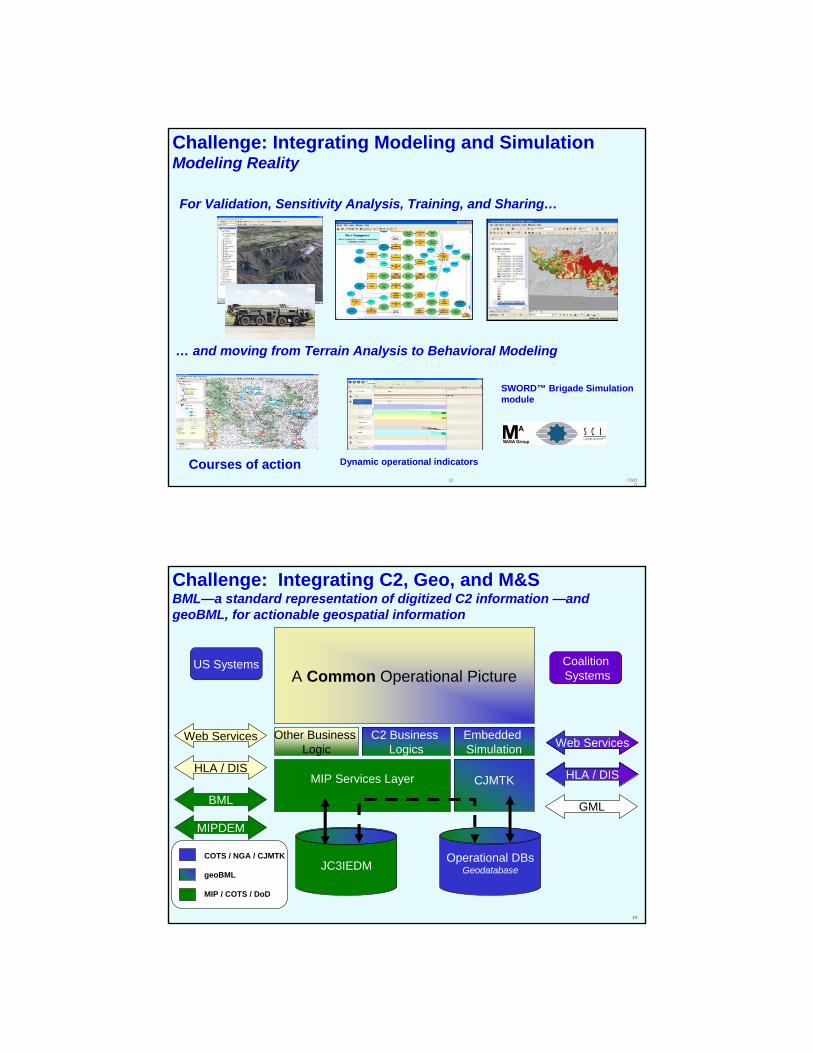
MIP Services Layer CJMTK
MIPDEM
BML
A Common Operational Picture
Other Business Logic
C2 Business Logics
GML
Web Services
HLA / DIS
Web Services
HLA / DIS
Operational DBsGeodatabaseJC3IEDM
US Systems CoalitionSystems
Embedded Simulation
COTS / NGA / CJMTK
geoBML
MIP / COTS / DoD
Challenge: Integrating C2, Geo, and M&SBML—a standard representation of digitized C2 information —and geoBML, for actionable geospatial information
15
What Will This Mean For Operations?
How do integrate with the Orders process?
16
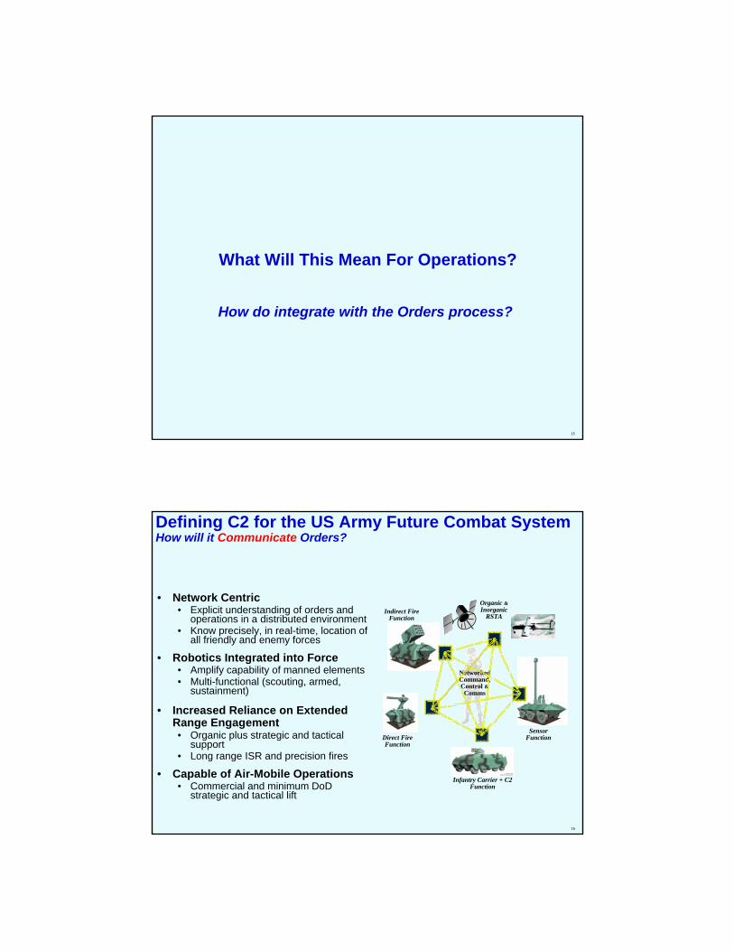
Defining C2 for the US Army Future Combat System How will it Communicate Orders?
• Network Centric• Explicit understanding of orders and
operations in a distributed environment• Know precisely, in real-time, location of
all friendly and enemy forces
• Robotics Integrated into Force• Amplify capability of manned elements• Multi-functional (scouting, armed,
sustainment)
• Increased Reliance on Extended Range Engagement• Organic plus strategic and tactical
support• Long range ISR and precision fires
• Capable of Air-Mobile Operations• Commercial and minimum DoD
strategic and tactical lift
Direct Fire Function
Infantry Carrier + C2 Function
Indirect Fire Function
Sensor Function
Organic &Inorganic
RSTA
Networked Command,Control &Comms
17
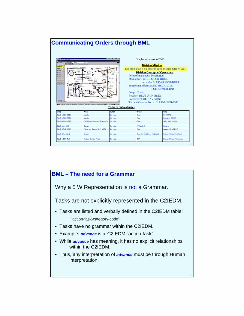
Communicating Orders through BML
Graphics convert to BML
Division attacks on order in zone to seize OBJ SLAM.Division Mission
Form of maneuver: PenetrationMain effort: BLUE-MECH-BDE2,
on order BLUE-ARMOR-BDE1Supporting effort: BLUE-MECH-BDE1
BLUE-ARMOR-BN1Deep: NoneReserve: BLUE-AVN-BDE1Security: BLUE-CAV-SQN1Tactical Combat Force: BLUE-MECH-TM1
Division Concept of Operations
Tasks to Subordinates
•Protect (Division Rear Area)•DSA•On order•Tactical Combat Force•BLUE-MECH-TM1
•Protect (Division left flank)•Zone (PL AMBER to PL BLUE)•On order•Screen•BLUE-CAV-SQN1
•Support (B-A-BDE1)•Zone•On order•Follow and Support (B-A-BDE1)•BLUE-ARMOR-BN1
•Reserve•AA EAGLE•On order•Occupy•BLUE-AVN-BDE
•Seize (OBJ SLAM)•Zone•On order•Follows and Assumes (B-M-BDE2)•BLUE-ARMOR-BDE1
•Penetrate (MRR2)•Zone•On order•Attacks•BLUE-MECH-BDE2
•Fix (MRR1)•Zone•On order•Attacks•BLUE-MECH-BDE1
•Why•Where•When•What•Who
18
BML – The need for a Grammar
Why a 5 W Representation is not a Grammar.
Tasks are not explicitly represented in the C2IEDM.
• Tasks are listed and verbally defined in the C2IEDM table:“action-task-category-code”.
• Tasks have no grammar within the C2IEDM.• Example: advance is a C2IEDM “action-task”.• While advance has meaning, it has no explicit relationships
within the C2IEDM.• Thus, any interpretation of advance must be through Human
interpretation.
19
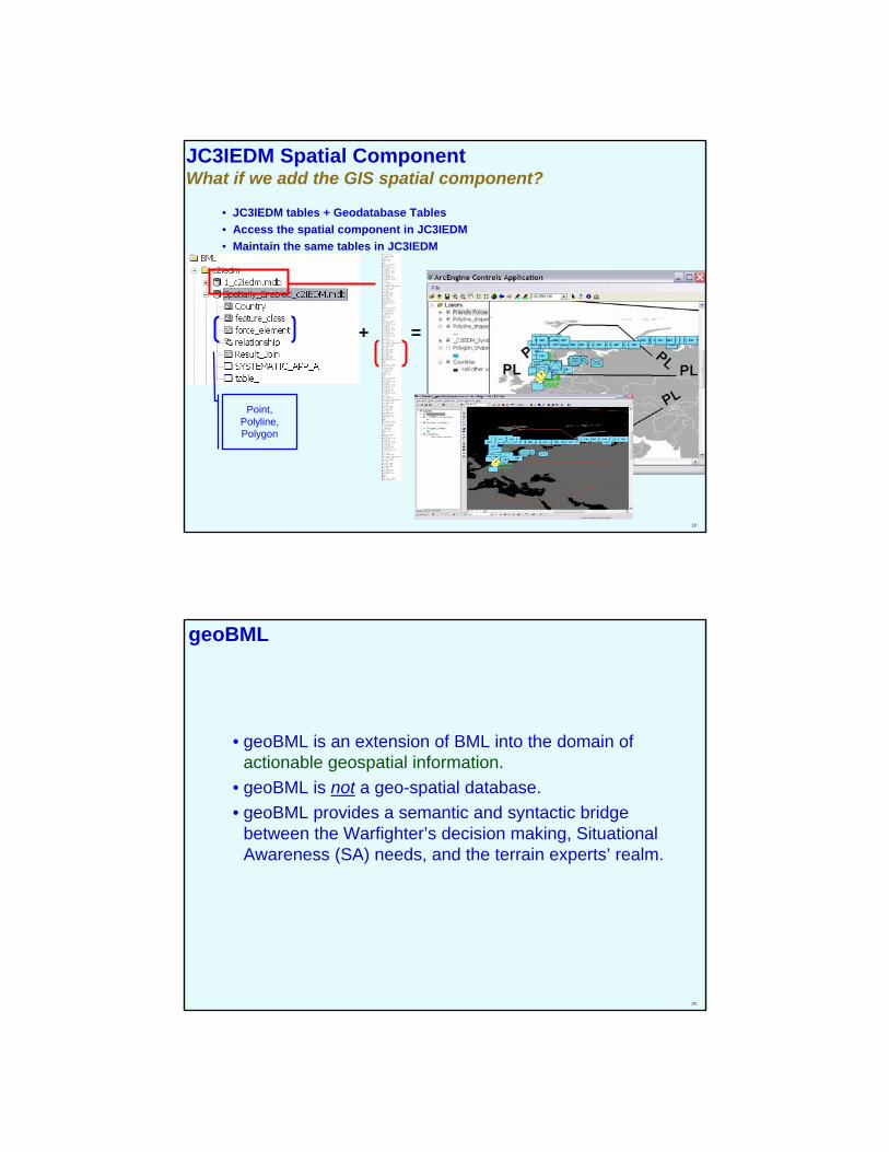
JC3IEDM Spatial ComponentWhat if we add the GIS spatial component?
• JC3IEDM tables + Geodatabase Tables• Access the spatial component in JC3IEDM• Maintain the same tables in JC3IEDM
+ =
Point, Polyline, Polygon
20
geoBML
• geoBML is an extension of BML into the domain of actionable geospatial information.
• geoBML is not a geo-spatial database.• geoBML provides a semantic and syntactic bridge
between the Warfighter’s decision making, Situational Awareness (SA) needs, and the terrain experts’ realm.
21
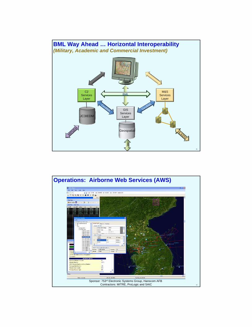
BML Way Ahead … Horizontal Interoperability(Military, Academic and Commercial Investment)
JC3IEDM
MIPDEMHLA/DIS
Geospatial
C2 Services
Layer
M&S Services
Layer
GIS Services
Layer
BML
GeoBML GeoBML
GM
L
22
Sponsor: 753rd Electronic Systems Group, Hanscom AFBContractors: MITRE, ProLogic and SAIC
Operations: Airborne Web Services (AWS)
23
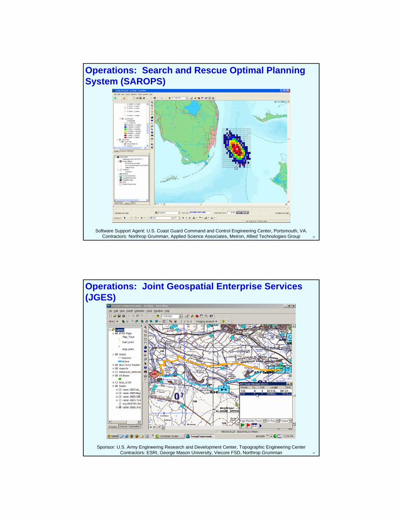
Operations: Search and Rescue Optimal Planning System (SAROPS)
Software Support Agent: U.S. Coast Guard Command and Control Engineering Center, Portsmouth, VA.Contractors: Northrop Grumman, Applied Science Associates, Metron, Allied Technologies Group
24
Sponsor: U.S. Army Engineering Research and Development Center, Topographic Engineering CenterContractors: ESRI, George Mason University, Viecore FSD, Northrop Grumman
Operations: Joint Geospatial Enterprise Services (JGES)
25
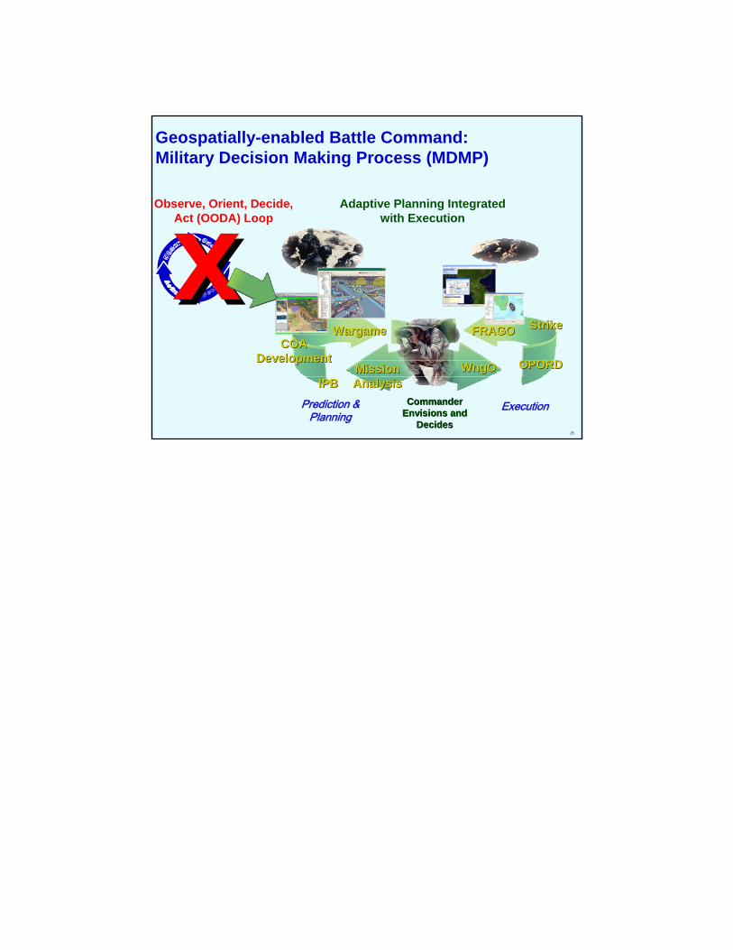
xxGeospatially-enabled Battle Command:Military Decision Making Process (MDMP)
Mission Mission AnalysisAnalysisIPBIPB
WargameWargame
OPORDOPORD
StrikeStrike
CommanderCommanderEnvisions and Envisions and
DecidesDecides
Observe, Orient, Decide, Act (OODA) Loop
Adaptive Planning Integrated with Execution
Prediction & Planning
Execution
COACOADevelopmentDevelopment
FRAGOFRAGO
WngOWngO
Top Related