


Languages
Pages
Legal


LAS Files Available for Download USGS geologic cross section C-C’ includes 11 wells in the northern Appalachian basin
extending from Erie County, Ohio, in the west to Bedford County, Pennsylvania, in the east. These wells penetrate strata from surface elevations to depths varying between 4,463 feet (3,621 feet below sea level; well 1) and 21,460 feet (18,847 feet below sea level; well 9). The strata range in age from Pennsylvanian (wells 5, 6, and 7) to Mesoproterozoic (wells 1, 2, and 3). Table 1 summarizes information about the 11 wells and their drilling depths. The 20 LAS files named in table 1 are available for download and use from the index page from this report.
Reference Cited Ryder, R.T., Trippi, M.H., Swezey, C.S., Crangle, R.D., Jr., Hope, R.S., Rowan, E.L., and Lentz, E.E. ,
2008, A regional geologic cross section through the Appalachian basin from near the Findlay arch, Erie County, north-central Ohio, to the Valley and Ridge province, Bedford County, south-central Pennsylvania [abs.]: Final Program and Abstracts for the American Association of Petroleum Geologists – Society of Petroleum Engineers Eastern Section Meeting [Pittsburgh, PA, 11-15 October 2008], P. 6.
7

Figure 7. Selected segment of geologic cross section C-C’ penetrated by well No. 7 (Richard J. Ashcroft No. 1) (black vertical line with orange depth tick marks) showing the accompanying digitized gamma ray log of the well (wavy red line) and the selected lithologic units. Depths (in thousands of feet) are identified on the well. The area in the white box and the detailed chart to the left correspond to data listed in figure 2 and portions of figures 3 and 4 between depths 4590 and 4605. Lithologic units and lines: dark gray, black shale; light gray, shale; dark blue, limestone; wavy line, unconformity; subhorizontal black line on black shale at 5,000 feet, a bedding-plane detachment fault.
8

1
Table 1. Twenty Log ASCII Standard (LAS) files for gamma ray logs of 11 wells used to construct geologic cross section C-C’ through the Appalachian basin from Erie County, Ohio, to Bedford County, Pennsylvania.
[Items used: No., number; API, American Petroleum Institute; TD, total depth; ASCII, American Standard Code for Information Interchange; latitude and longitude values from state surveys] Well No.
Well name and operator
Location API No. Latitude Longitude TD (feet)
Date(s) of log run(s) LAS interval (feet)
Horizontal scale range and units
LAS file names
1 Krysik-Wakefield No.1; Sun Oil Co.
Florence Township, Erie County, Ohio; Kipton, Ohio, 7.5' quadrangle
34-043-20011
41.304302 -82.350463
4,463 6/11/1966 0-4,460 0-200 API units KrysikGR0-4460.las
2 A. & A. Born No.1; East Ohio Gas
Henrietta Township, Lorain County, Ohio; Kipton, Ohio, 7.5’ quadrangle
34-093-20794
41.289298 -82.320852
4,591 11/14/1960 0-4,581 0-21 microRoentgens per hour
BornGR0-4581.las
3 F.L. Smith Estate No. 1-A; Wiser Oil
Hinckley Township, Medina County, Ohio; West Richfield, Ohio, 7.5’ quadrangle
34-103-21143
41.228910 -81.702700
7,040 11/5/1958 (Run 1); 11/28/1958 (Run 2);1/3/1959 (Run 3)
0-3,556; 3,556-5,849; 5,849-7,029
0-10 API units;0-7.5 API units;0-10 API units
SmithGR0-3556.las SmithGR3556.5-5849.las SmithGR5849.5-7026.las
4 B. Westfall No. 1-381; Belden & Blake Co. Ltd. Partnership No. 9
Marlboro Township, Stark County, Ohio; Hartville, Ohio, 7.5’ quadrangle
34-151-21081
40.952470 -81.262630
7,961 6/5/1965 0-7,965 0-200 API units WestfallGR50-7965.las
5 Frank Murray No. 3; Management Control Corp.
Hanover Township, Columbiana County, Ohio; Lisbon, Ohio, 7.5’ quadrangle
34-029-20648
40.785780 -80.870420
10,242 7/28/1970 0-10,235 0-200 API units MurrayGR0-10235.las
6 S. Minesinger No. 1; Humble Oil
Clay Township, Hancock County, West Virginia; East Liverpool South, West Virginia,
47-029-00080
40.539722 -80.556114
10,387 4/23/1965 (Birdwell Run 1); 5/23/1965 (Schlumberger Run 1); 8/10/1965
0-1,025; 1,027-5,714; 5,550-10,377
0-30 API units;0-150 API units; 0-150 API units
MinesingerGR0-1025.las; MinesingerGR1000-10414.las

2
Pennsylvania, and Ohio, 7.5’ quadrangle
(Schlumberger Run 2)
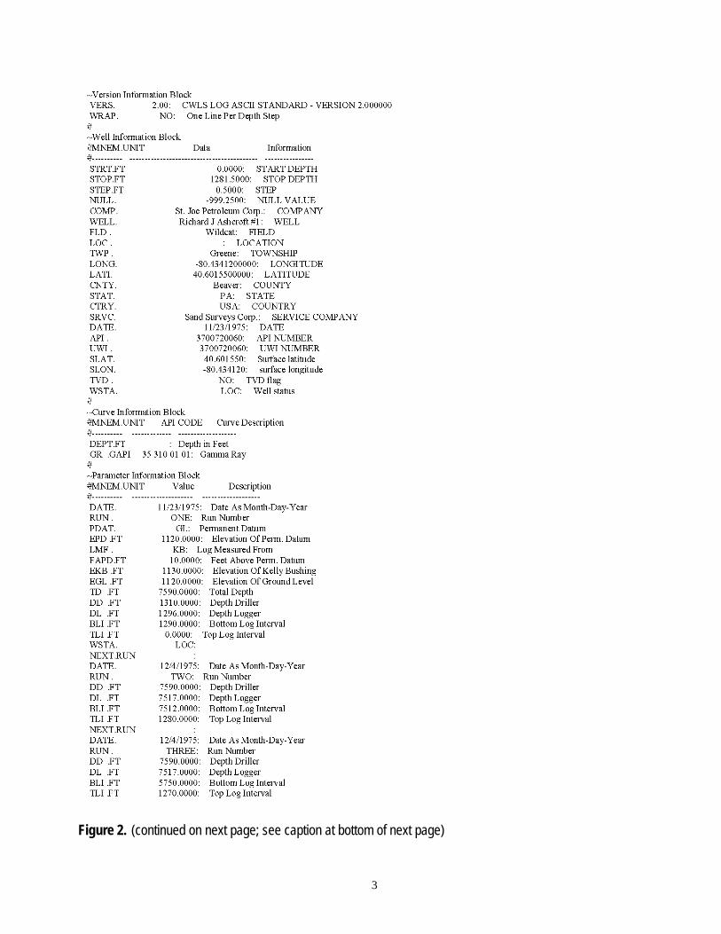
7 Richard J. Ashcroft No. 1; St. Joe Petroleum Corp.
Greene Township, Beaver County, Pennsylvania; Hookstown, Pennsylvania, 7.5’ quadrangle
37-007-20060
40.601550 -80.434120
7,590 11/23/1975 (Run 1);12/4/1975 (Run 2); 12/4/1975 (Run 3)
0-1,291; 1,280-7,512; 1,270-5,750
0-200 API units; 0-400 API units; 0-400 API units
AshcroftGR0-1281.5.las; AshcroftGR1282-7504.las
8 E.C. Ricks No. 1; William E. Snee, et al.
Wharton Township, Fayette County, Pennsylvania; Brownfield, Pennsylvania, 7.5’ quadrangle
37-051-20056
39.843460 -79.654270
12,041 9/22/1966 (Run 1); 3/27/1967 (Run 2)
0-9,330; 8,800-12,033
0-250 API units; 0-500 API units
RicksGR0-9300.las; RicksGR9300-11400.las; RicksGR11400-12040.las
9 Leonard Svetz No. 1; Amoco Producing Co.
Middle Creek Township, Somerset County, Pennsylvania; Kingwood, Pennsylvania, 7.5’ quadrangle
37-111-20045
39.977764 -79.333868
21,460 11/1/1973 (Run 1); 5/23/1974 (Run 1); 7/21/1974 (Run 2); 8/21/1974 (Run 3);8/21/1974 (Run 1);12/20/1974 (Run 2)
0-1,450; 1,450-9,889; 9,800-11,910; 11,700-14,622; 10,250-15,792; 10,348-21,333
0-200 API units; 0-200 API units; 0-200 API units; 0-200 API units; 0-200 API units; 0-200 API units
SvetzGR75-1449.5.las; SvetzGR1450-10249.5.las SvetzGR10250-21350.las
10 Schellsburg No. 1; Kerr-McGee Corp.
Napier Township, Bedford County, Pennsylvania; Bedford, Pennsylvania, 7.5’ quadrangle
37-009-20034
40.103520 -78.616100
11,850 12/9/1964 (Run 1); 2/23/1965 (Run 2); 3/24/1965 (Run 3)
0-3,124; 3,124-9,262; 9,262-11,834
0-150 API units; 0-150 API units; 0-150 API units
SchellsGR0-5550.las; SchellsGR5550-11812.5.las
11 Fred Steele No. 1; Atlantic Richfield Co.
Snake Spring Township, Bedford County, Pennsylvania; Everett West, Pennsylvania, 7.5’ quadrangle
37-009-20060
40.015830 -78.422050
15,500 12/21/1984 (Run 1);3/1/1985 (Run 2); 3/7/1985 (Run 3); 5/4/1985 (Run 4)
150-3,935; 3,936-10,860; 10,800-11,344; 11,450-15,468
0-200 API units; 0-200 API units; 0-200 API units; 0-200 API units
SteeleGR150-15425.las
Top Related