


Languages
Pages
Legal


Irrigationin Alberta
Contents. . . . . . .
The benefits of irrigation .................................................... 1
A legacy of cooperation ...................................................... 2
Alberta's irrigation system ..................................................4
Getting the water to the crops .............................................8
Irrigation Districts Map..................................................... 11
Development and diversification ...................................... 12
Places for people, pike and pelicans ................................. 18
Breaking new ground ........................................................21
For more information ........................................................23
Metric Conversions:
1 kilometre (km) = 0.62 miles
1 metre = 3.28 feet
1 centimetre (cm) = 0.39 inches
1 millimetre (mm) = 0.039 inches
1 hectare = 2.471 acres
1 cubic decametre = 0.81 acre feet

A modern pivot irrigation system irrigates a field of canola.
The benefits of irrigation
tho
usa
nd
so
f(a
ctu
al)
he
cta
res
growth of alberta’s irrigation districts
More than a century ago, water for Alberta's first irrigation
project was diverted from Fish Creek, near Calgary. Now,
at the beginning of the 21st century, about 600,000
productive hectares of land, mostly within the 13 irrigation
districts in the southern part of the province, are receiving
water through irrigation. Millions of litres of irrigation
water are also being used to support the growth of Alberta's
livestock and food processing industries. Directly and
indirectly, irrigation adds about 35,000 jobs and more than
$940 million dollars a year to the provincial economy.
Alberta irrigation helps keep a regular supply of low cost,
high quality food on tables in Canada and throughout the
world. The province's expertise in irrigation technology
and research is also helping increase world food supplies
in countries like Egypt, Pakistan, India and China.
Agronomic and economic benefits aren't the only impacts
of irrigation. The province's irrigation reservoirs are a
recreational destination for both Albertans and visitors to
the province. Reservoirs and canals provide critical habitat
for birds, mammals, fish and other wildlife on the dry
prairies. Irrigation is also used to supply domestic,
municipal and industrial water to many small communities
and farmsteads in the province. The assurance of a good
quality water supply has helped stabilize these farms and
communities, and in turn, has led to improved economic
and social conditions for rural people.
In recent years, the development and operation of
irrigation systems is focusing more on environmental
concerns. Increased demands on limited water resources
are challenging further development and encouraging
agricultural producers, industry and government to make
more efficient use of the water supply and the irrigation
systems already in place. The goal in the next decades will
be to further improve the irrigation infrastructure and
water use efficiency, while safeguarding the environment.
Already, rehabilitation of the irrigation infrastructure and
use of advanced on-farm irrigation technology are
conserving water and energy. Hydro-electric facilities are
being installed on the irrigation infrastructure to reduce our
dependence on fossil fuels for generating power. Food
processing wastewater is being treated and used to irrigate
crops. Research and development on more drought-
resistant crop varieties will also save water.
This booklet briefly examines the past history and present
status of irrigation in Alberta to help readers understand
the contribution irrigation has made to Alberta society and
the challenges facing the irrigation industry in the future.
1911 21 31 41 51 61 71 81 91 19990
100
200
300
400
500
1

Farmers at a demonstration of surface irrigation using syphon tubes.
In 1903, the Canadian Pacific Railway began construction
of a diversion weir on the Bow River near Calgary and a
system of canals to bring water to 80,000 hectares of
farmland, called the Western Block. It was hoped the
irrigation project would increase shipping and passenger
business and the sale of land acquired during the building
of its transcontinental rail line. Six years later, the CPR
started work on an even larger project, a diversion
structure downstream on the Bow River, near Bassano, and
a distribution and canal system to irrigate the Eastern
Block, about 160,000 hectares near Brooks.
In the long run, these large commercial ventures were not
financially successful. However, they laid the groundwork
for a series of legislative enactments aimed at developing
the irrigation potential of the province.
In 1914, the government of Alberta passed the Irrigation
Districts Act. The legislation allowed land owners to
organize themselves into local cooperatives, which could
then issue bonds for the construction of large-scale
irrigation projects. The federal and provincial governments
would help with construction of the headworks.
Government guarantees were established to help farmers
mortgage their land to provide funds for the work done by
the districts. The districts were alsogiven the authority to
levy local taxes for the operation and maintenance of the
irrigation projects and to deal with the day-to-day
administration of the systems.
The concept of farmer-owned and operated irrigation
districts, unique to Alberta, was a natural outgrowth of the
The Irrigation Districts Act
A legacy of cooperation
Irrigation in Alberta owes its existence to the foresight and
optimism of 19th century government officials, the
speculative zeal of Canada's early entrepreneurs, and the
spirit and technical know-how of pioneering settlers.
The construction of the Canadian Pacific Railway in the
late 1800s started a minor land boom on Canada's prairies,
one the railway company and the federal government
hoped to foster. Irrigation was seen as a key element in
attempts to attract settlers. After a prolonged drought
struck the area, and through the urging of Department of
the Interior officials, William Pearce and J.S. Dennis, the
federal government passed the Northwest Irrigation Act of
1894. Rather than leave water rights in the hands of
property owners, the Act gave control of irrigation
diversion and water use to the federal government.
All surface waters were declared the property of the
Crown, and the rights to use the water could be obtained
only through government license. Both the water resources
and potential agricultural lands were surveyed, to see
which areas would benefit most from irrigation and where
irrigation was most practical or feasible.
In Alberta, however, small-scale irrigation works were
already being built. Mormon settlers, in particular, were
putting the experiences and technical skills learned in their
former Utah homeland to work, creating effective
irrigation systems in the dry southern part of the province.
Work was completed on the first successful, large-scale
irrigation project in 1900. This system — 184 kilometres
of canal southwest of Lethbridge — opened thousands of
hectares of land to colonization.
2

government's commitment to the development of
agriculture and to the farmers' willingness to work together
for mutual benefits. In all, 13 irrigation districts were
formed in subsequent years, with capitalization and
operating expenses shared by the provincial and federal
governments as well as the districts themselves. In 1919,
more than 7,500 hectares of district land were in irrigated
production.
Though irrigation continued to grow as both an
economic and a social force, returns on investments
during the 1920s were not as high as anticipated. To
keep the industry growing, and because it was felt
benefits would accrue to society as a whole, the
provincial and federal governments agreed to fund all
major capital works. They also helped pay some of
the debts which had been incurred by the farmer
cooperatives and private corporations in building the
existing infrastructure.
The governments also encouraged the planting of
higher-value crops and promoted better farming
practices, initiating technical assistance and education
programs. Soil surveys were undertaken and
information on climate and other geographic factors
was gathered, starting a data bank that is still being
referenced and expanded today.
In 1931, following the transfer of natural resources
jurisdiction from the federal government to the
provinces, Alberta passed its first Water Resources
Act, solidifying the province's support of the irrigation
districts. The creation of the Prairie Farm
Rehabilitation Administration (PFRA) in 1935, as an
agency of Agriculture and Agri-food Canada, initiated
an era of increased federal government involvement in
irrigation. Through the PFRA, the federal government
became a major developer of new storage and
delivery systems, including the St. Mary, Milk River
Ridge and Waterton reservoirs, as well as the
associated diversion canals. By 1950, the irrigation
districts serviced more than 182,000 hectares of farm
land.
A new provincial irrigation act was passed in 1968,
and a year later, water apportionment was revised
undera reconstituted Prairie Provinces Water Board.
This cooperative government effort allocated about
one third of the prairie's total surface water resources
Greater government support
for consumptive use in Alberta, with the remaining
water mandated for downstream flows.
Though basic maintenance on the infrastructure had
been looked after by the irrigation districts, it became
apparent after World War II that a major rehabilitation
and expansion program was needed. In 1950, in
cooperation with the PFRA, the province began
rebuilding and enlarging the main delivery system in
the Bow River Irrigation District, as well as in the St.
Mary River Irrigation District from Taber to Medicine
Hat. This work was continued under the Alberta
Irrigation Capital Works Program and broadened to
include the other irrigation districts.
By the beginning of the 1970s, the federal
government felt it had achieved its goal of stabilizing
irrigation in Alberta and transferred most of its
interests to the province. The province thus assumed
even greater responsibility for rehabilitation and
expansion of the distribution infrastructure. As part of
a cost-sharing program with the irrigation districts,
the Alberta government paid 86% of construction
expenses and provided engineering and agrological
services. In 1976, with the initiation of the Alberta
Heritage Trust Fund, more money was allocated for
irrigation capital works. (In 1995, the cost-sharing
formula was changed. The provincial government
now pays 75% of rehabilitation costs, and the
irrigation districts pay 25%.)
IRRIGATION DISTRICT (I.D.) Year I.D.Formed
First WaterDrawn
Taber I.D.
Lethbridge Northern I.D.
United I.D.
Mountain View I.D.
Raymond I.D.
Magrath I.D.
Eastern I.D.
Leavitt I.D.
Western I.D.
Aetna I.D.
Ross Creek I.D.
St. Mary River I.D.
Bow River I.D.
1917
1919
1921
1923
1925*
1926*
1935*
1936
1944*
1945
1949
1968*
1968*
1917
1923
1923
1931
1900
1900
1914
1944
1907
1959
1954
1900
1920
* formation of an irrigation district from existing irrigated areas
3

Alberta’s irrigation system
<200
200 - 250
250 - 300
300 - 350
350 - 400
>400
total precipitation (mm)may 1 - august 31
Grande Prairie
Edmonton
RedDeer
Lethbridge
Calgary
MedicineHat
Unlike the American Midwest, where irrigation depends so
heavily on dwindling groundwater resources, Alberta's
irrigation water comes from its rivers. Through a diverse
irrigation infrastructure, spring precipitation and mountain
snowmelt is rechannelled, stored and later put to use in the
more arid parts of the province, where it's most needed.
Though Alberta has abundant water resources,
precipitation is scarcest where the agricultural potential is
greatest. The southern part of the province, with a growing
season of about 150 days, receives only 300-450 mm of
precipitation annually. Less than half falls from May
through August, during the growing season.
The combination of abundant sunshine, warm temperatures
and a long growing season results in an average net water
deficit of 380 mm a year for crops grown in the southeast
corner of the province. Though the deficit is less in other
parts of southern Alberta,chinook winds reduce moisture
retention. Irrigation allows water stored in the spring to be
used in midsummer, to help balance these deficits. Limits
on irrigation expansion were established in 1991, to offset
concerns about scarce water supplies in the South
Saskatchewan River Basin.
Alberta is unique in Canada in requiring land to be
classified suitable for irrigation under sustained
production. Standards for soil classification irrigability
consider soil depth, parent material, texture, drainage,
salinity, pH, erodibility and organic matter content.
Topography, groundwater factors and natural vegetation
are also considered before an irrigation water right is
granted.
Most of the soils in southern Alberta are ideally suited to
irrigation. The area's medium to fine-textured glacial tills
have good water-holding capacities and slow movement
through the lower root zone. The coarse-textured soils are
also productive, though more difficult to manage due to a
high water percolation rate and low water retention.
The Alberta Irrigation Districts Act, which came into effect
in 2000, allows irrigators greater autonomy and
independence, but with greater accountability. Under the
Act, an irrigator can, with the consent of their irrigation
district, change the point of diversion and the location of
an irrigated field. He may also transfer a water right to a
different piece of land, as long as it also is classified for
irrigation.
Alberta Environment maintains the right to change or
revoke a license if water resources are being negatively
impacted. Interbasin transfers are not allowed, but the
government can issue new licenses, provided the resource
base has sufficient water.
The provincial government, through Alberta Environment
and Alberta Agriculture, Food and Rural Development
(AAFRD), also maintains partial responsibility for
irrigation planning, research and infrastructure upgrading.
In the year 2000, for example, approximately $47 million
was allocated for infrastructure upgrades alone.
AAFRD's Irrigation Branch provides research,
consultation, and extension services to the irrigation
industry through its Farm Irrigation Management,
Irrigation Development, and Resource Conservation
sections. A team of specialists with the Irrigation Branch
4
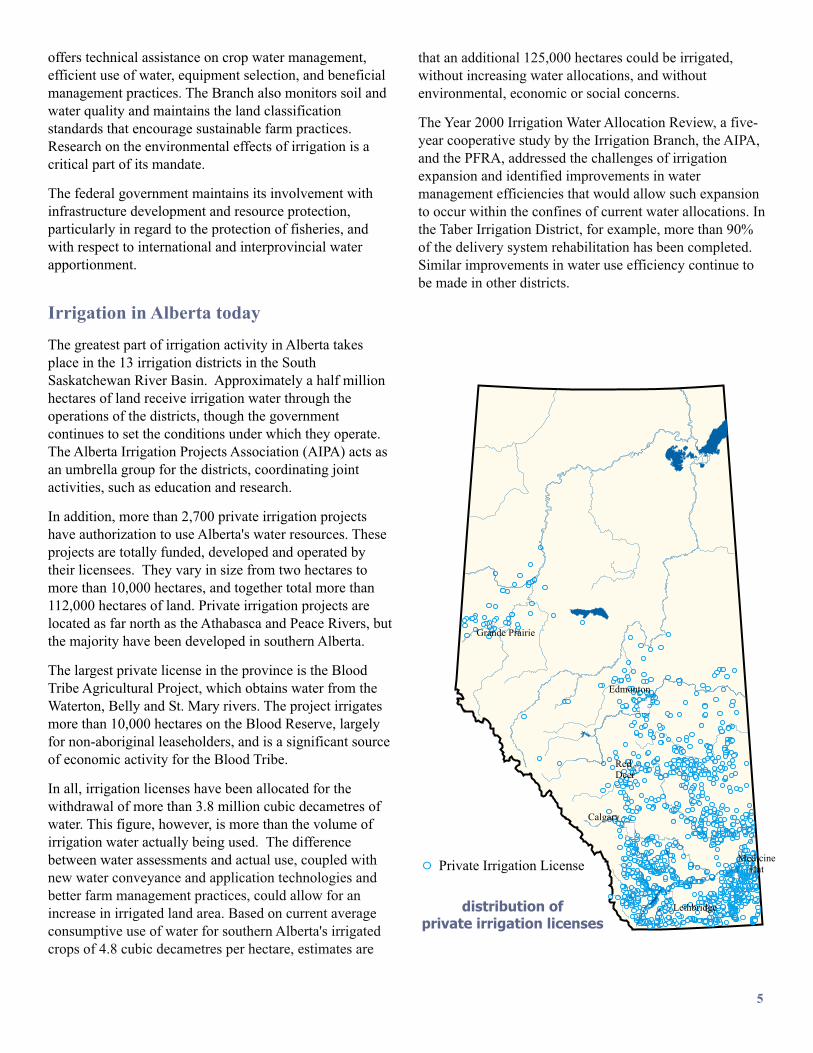
distribution ofprivate irrigation licenses
Grande Prairie
Edmonton
RedDeer
Lethbridge
Calgary
MedicineHatPrivate Irrigation License
offers technical assistance on crop water management,
efficient use of water, equipment selection, and beneficial
management practices. The Branch also monitors soil and
water quality and maintains the land classification
standards that encourage sustainable farm practices.
Research on the environmental effects of irrigation is a
critical part of its mandate.
The federal government maintains its involvement with
infrastructure development and resource protection,
particularly in regard to the protection of fisheries, and
with respect to international and interprovincial water
apportionment.
The greatest part of irrigation activity in Alberta takes
place in the 13 irrigation districts in the South
Saskatchewan River Basin. Approximately a half million
hectares of land receive irrigation water through the
operations of the districts, though the government
continues to set the conditions under which they operate.
The Alberta Irrigation Projects Association (AIPA) acts as
an umbrella group for the districts, coordinating joint
activities, such as education and research.
In addition, more than 2,700 private irrigation projects
have authorization to use Alberta's water resources. These
projects are totally funded, developed and operated by
their licensees. They vary in size from two hectares to
more than 10,000 hectares, and together total more than
112,000 hectares of land. Private irrigation projects are
located as far north as the Athabasca and Peace Rivers, but
the majority have been developed in southern Alberta.
The largest private license in the province is the Blood
Tribe Agricultural Project, which obtains water from the
Waterton, Belly and St. Mary rivers. The project irrigates
more than 10,000 hectares on the Blood Reserve, largely
for non-aboriginal leaseholders, and is a significant source
of economic activity for the Blood Tribe.
In all, irrigation licenses have been allocated for the
withdrawal of more than 3.8 million cubic decametres of
water. This figure, however, is more than the volume of
irrigation water actually being used. The difference
between water assessments and
Irrigation in Alberta today
actual use, coupled with
new water conveyance and application technologies and
better farm management practices, could allow for an
increase in irrigated land area. Based on current average
consumptive use of water for southern Alberta's irrigated
crops of 4.8 cubic decametres per hectare, estimates are
that an additional 125,000 hectares could be irrigated,
without increasing water allocations, and without
environmental, economic or social concerns.
The Year 2000 Irrigation Water Allocation Review, a five-
year cooperative study by the Irrigation Branch, the AIPA,
and the PFRA, addressed the challenges of irrigation
expansion and identified improvements in water
management efficiencies that would allow such expansion
to occur within the confines of current water allocations. In
the Taber Irrigation District, for example, more than 90%
of the delivery system rehabilitation has been completed.
Similar improvements in water use efficiency continue to
be made in other districts.
5
Top Related