


Languages
Pages
Legal


Integrated Field to Finish
BIM for Surveyors
Boris Skopljak ([email protected])
Market Manager, Trimble Geospatial Office Software

• Trimble Introduction
• BIM relevance in Trimble
• Trimble Buildings
• Civil Engineering and Construction
• BIM in Geospatial
• Field to Finish Workflows
• Expanding Business Opportunities
• QA
Agenda

InnovationCompany
NASDAQ:
TRMB
$2.65B
In Revenue
31%+
Building & Infrastructure
2,000
Patents
360 Construction Workflow
& Technology Patents
14%
R&D re-invested
People
9000+ Employees
in 35 Countries
800+ Construction
Professionals
Global Customers
in 150 countries
Trimble Snapshot

Transportationand Logistics
GeospatialBuildings Civil Engineering
and ConstructionAgriculture
Core Business Franchises
Our core industries are global trillion $ industries which operate in demanding
environments, with technology adoption in the early phases

GPS Productivity Integrated
Work Process
6
Impact of Innovation
Positioning
Trimble’s Transformation

10
0
6
5
6
0
CONSTRUCT
OPERATE
SURVEY
OPTIMIZE
DESIGN
%
% 25
%
35
%
%
Supporting Every Phase of the Project

BIM Tools – Trimble Connect
Communicate and manage data across
3D Models, 2D Drawings & Geospatial Data
Collaborate across
40+ tools & Integrations + 16
Languages

Trimble Buildings

Covering Entire Project Lifecycle

Trimble Buildings - Constructible BIM
11
CONCEPT DESIGN &
ENGINEERING
BID & AWARD FABRICATE & CONSTRUCT
LAYOUT, AS-BUILD & QA
Detailed
AE Model
Electrical
Model
Structural
Model
Mechanica
l Model
Constructible - Connected - Content - Collaboration
Digital
Asset
Handover

Trimble Buildings – Field Solutions
RTS-series
GNSS-series
RPT-series
Trimble Field Link
Data Preparation & Analysis
Trimble Field Link Office
Positioning Devices
TX-series
As-built
QA/QC
Trimble Field Points for AutoCad & Revit
Trimble Field Points for SketchUp

Trimble Constructible Model has high LOD

Building Construction
Reduction in
project duration
50% Reduction to overall
cost and schedule
15%
12
34
Professional Services
100%
Operations & Management
C
D
80%
50%
5%
10%
30%Reduced cost of
the field layout
Increase in accuracy and
reduced cost of rework
Reduction in
Lease Admin
Reduction in operations
and maintenance costs
Reduction in space planning
and management costs
Reduction in unique
building components50%
*Data derived through internal Trimble testing and customer interviews
Productivity, Project Duration & Cost Improvement

Our Vision
To be the essential ecosystem for the entire lifecycle of all of the world's infrastructure
Trimble Civil Engineering and Construction

Execute Construction
Trimble Connected Site® solutions for civil construction
projects can significantly improve efficiency and
productivity, while minimizing errors, waste and cost at
every stage of the project - from planning and design, to
construction, operation and maintenance.
• Fleet and Asset Management
• Machine Control
• Site Positioning Systems
• Software Solutions
• Weighing and Monitoring
Civil Construction
Reduction in rework
80%
50% Cost savings
Increase in accuracy
*Data derived through internal Trimble testing and customer interviews
50%

17

18
Role of the Geospatial
CEC
Buildings
Geospatial

Existing Condition Information
• Traditional deliverables (Level 0)• Topographic surveys, DTM
• Building surveys (floor plans, elevations)
• Intelligent data and models (Level 2+)• Point Clouds, imagery• 3D models, intelligent models
• Visualization and sharing Demarcation of new constructible models
Geospatial Data in BIM
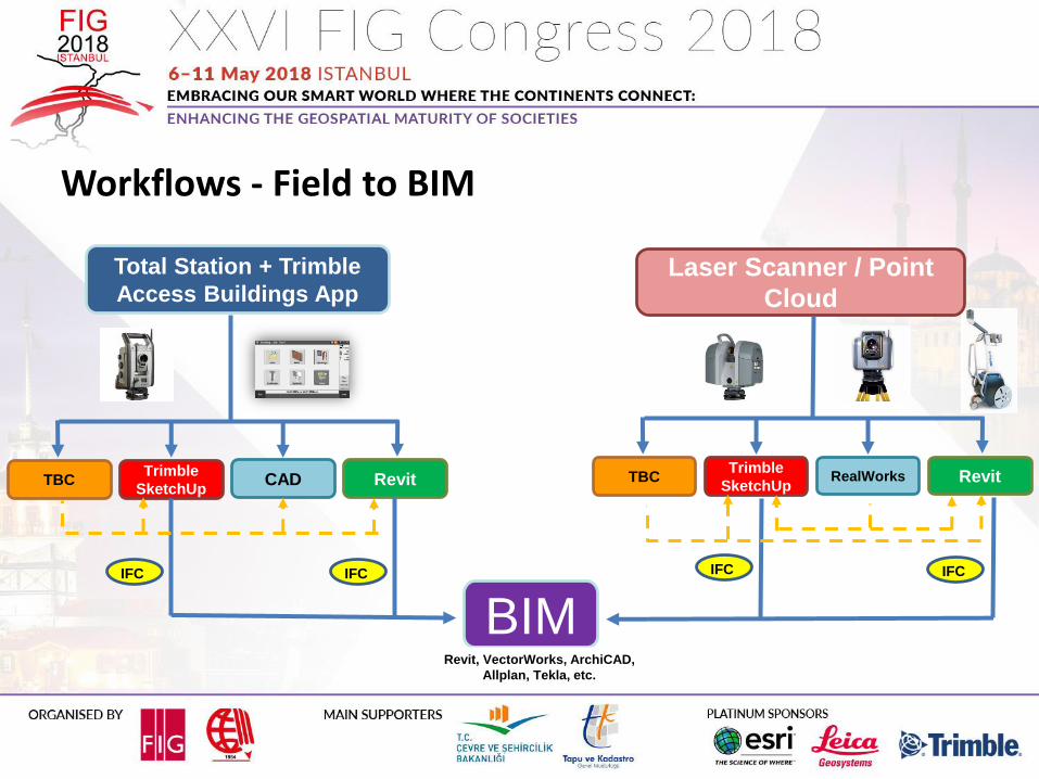
Total Station + Trimble
Access Buildings AppLaser Scanner / Point
Cloud
BIMRevit, VectorWorks, ArchiCAD,
Allplan, Tekla, etc.
TBCTrimble
SketchUpCAD Revit
IFCIFC IFC IFC
TBCTrimble
SketchUpRealWorks Revit
Workflows - Field to BIM

2007... 2012 2013 2014 2015 2016 2017 2018
Preconstruction and As-Built – 3D Growth

Trimble Access
Revit, VectorWorks,
ArchiCAD, Allplan, Tekla,
Connect, etc
TBCBIM
Workflows – BIM to Field

Trimble
Access
Buildings
Trimble
Business
Center
Trimble
SketchUp
AutoCAD /
other CAD
Job
JobXML
JobXML
DXFE
nha
nce
d
DW
G /
DX
F
IFCBIM
Revit, VectorWorks,
ArchiCAD, Allplan,
Tekla, etc
Workflows - Buildings App for Trimble Access


Typical Surveyor Scope
▪ Property corners and lines, Bldg
corners, topo’s...
Additional items needed and available in
BIM:
▪ Fencing, trailers, stockpiles, laydown
area, control point, storm water mgmt,
mock up areas, crane pads
Expanding Business Opportunity - Surveying Site Layout

Typical Surveyor Scope
▪ Utilities 25’ - 50’ OC with offsets and
pins for changes in
direction/intersections
Additional items needed and available in
BIM:
▪ As-builts for all utilities including
temporary gas, electrical, plumbing,
low-volt, irrigation lines
Expanding Business Opportunity - Surveying Site Layout

Selling the Value – Start with Viewers and SketchUp

Virtual/Augmented/Mixed Reality
Trimble SketchUp Viewer for HoloLens– Collaborate in real-time in the
immersive environment– Fly around project models, query
entities or measure
Trimble SiteVision– High Accuracy Outdoor Data Viewing– Combines design information and data
with actual environment

Thank You

Top Related