


Languages
Pages
Legal


INNOVATION PARK AT THE UNIVERSITY OF TEXAS AT ARLINGTON Research and Innovation in a Changing Climate
Layal Bitar-Ghanem: Masters Candidate, Landscape Architecture, BS in Landscape Design and Ecosystem Management
Riza Pradhan: Masters Student, Landscape Architecture, BArch in Architecture
Kerry Gray-Harrison: Masters Student, Landscape Architecture, BS in Botany, BS in Interior Design
Somayeh Moazzeni, PhD Student, Urban Planning and Public Policy, Masters in Geography and Urban Planning
Faculty Advisor: Taner Özdil, PhD, Associate Professor, Planning and Landscape Architecture
Team registration number: M20
ABSTRACT The North Central Texas area expects to see rising temperatures and increased flooding as the result of climate change. The University of Texas at Arlington, located in the North Central Texas region, is preparing for these changes as it plans construction for changing student needs as well as increased enrollment. Innovation Park is the student-proposed research quad that transforms 17 acres of parking lots, draining directly into Trading House Creek, into a solution that allows for increased storm intensity as well as considers higher temperatures. This new development will create a strong visual identity to pedestrian corridors connecting two recently completed LID projects on the north and east sides of campus. Innovation Park will incorporate bioswales, living walls, and extensive living roofs to mitigate heat gain on vertical and horizontal surfaces. Plantings are selected to provide maximum carbon sequestration and pollution filtration with as little irrigation as possible. For a two inch storm event, runoff will be reduced from the current 817,931 untreated gallons to 283,630 gallons of bio-filtered water. The University, by incorporating careful use of LID techniques, is making a solid investment in the future of its students as well as setting an example for the region.
Page 1
INTRODUCTION Climate change in the North Central Texas region is projected to increase flooding and
temperatures. This proposal relies heavily on several Low Impact Development (LID)
techniques: living roofs and walls, permeable paving, and vegetated swales (bioswales)
to reduce the impact of these projected changes. Living roofs and walls reduce the heat
gain of building surfaces, which reduces energy used to cool interiors as well as the
heat released from these surfaces at night. Vegetated swales use drought-and-flood
resistant plants to slow and filter pollution from stormwater runoff.
PROJECT GOALS:
Enhance the “placemaking” or identity of the campus by strengthening the visual
identity of the pedestrian corridors between recent LID construction projects on
the northern and eastern sides of campus.
Meet the University’s needs for new
construction and parking while reducing heat
load and runoff.
Limit Urban Heat Island Effect by
shading horizontal hardscape and roofs with
vegetation (living roofs) and vertical surfaces
with vegetation (mature trees and living walls).
Sequester carbon through planting of
trees and woody shrubs.
Reduce need for maintenance inputs
such as irrigation and mowing through the use
of well adapted and native plantings
Increase the quality of habitat for birds
and pollinators through use of multi-seasonal
flowering and fruiting species.
Reduce volume of water runoff and increase quality of water by using bioswales
along roadways and medians as well as permeable paving to clean particulates,
nitrogen, and phosphates from water.
Provide quality outdoor spaces for human comfort by careful use of prevailing
winds and siting of outdoor seating and gathering spaces.
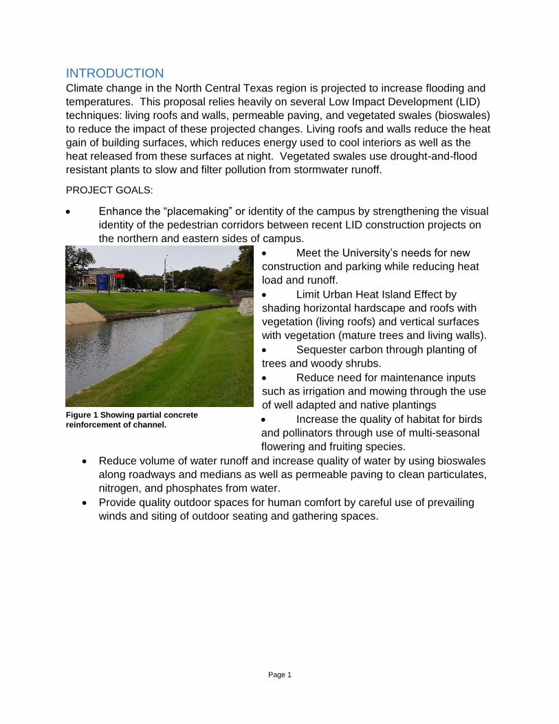
Figure 1 Showing partial concrete
reinforcement of channel.
Page 2
PROJECT CONTEXT
EXISTING CONDITIONS
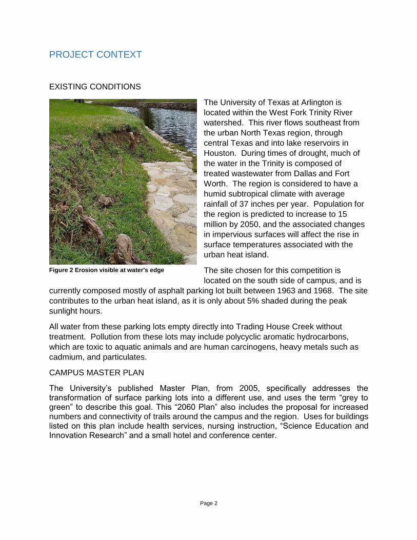
Figure 2 Erosion visible at water's edge
The University of Texas at Arlington is
located within the West Fork Trinity River
watershed. This river flows southeast from
the urban North Texas region, through
central Texas and into lake reservoirs in
Houston. During times of drought, much of
the water in the Trinity is composed of
treated wastewater from Dallas and Fort
Worth. The region is considered to have a
humid subtropical climate with average
rainfall of 37 inches per year. Population for
the region is predicted to increase to 15
million by 2050, and the associated changes
in impervious surfaces will affect the rise in
surface temperatures associated with the
urban heat island.
The site chosen for this competition is
located on the south side of campus, and is
currently composed mostly of asphalt parking lot built between 1963 and 1968. The site
contributes to the urban heat island, as it is only about 5% shaded during the peak
sunlight hours.
All water from these parking lots empty directly into Trading House Creek without
treatment. Pollution from these lots may include polycyclic aromatic hydrocarbons,
which are toxic to aquatic animals and are human carcinogens, heavy metals such as
cadmium, and particulates.
CAMPUS MASTER PLAN
The University’s published Master Plan, from 2005, specifically addresses the transformation of surface parking lots into a different use, and uses the term “grey to green” to describe this goal. This “2060 Plan” also includes the proposal for increased numbers and connectivity of trails around the campus and the region. Uses for buildings listed on this plan include health services, nursing instruction, “Science Education and Innovation Research” and a small hotel and conference center.
Page 3
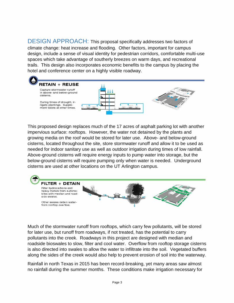
DESIGN APPROACH: This proposal specifically addresses two factors of
climate change: heat increase and flooding. Other factors, important for campus
design, include a sense of visual identity for pedestrian corridors, comfortable multi-use
spaces which take advantage of southerly breezes on warm days, and recreational
trails. This design also incorporates economic benefits to the campus by placing the
hotel and conference center on a highly visible roadway.
This proposed design replaces much of the 17 acres of asphalt parking lot with another
impervious surface: rooftops. However, the water not detained by the plants and
growing media on the roof would be stored for later use. Above- and below-ground
cisterns, located throughout the site, store stormwater runoff and allow it to be used as
needed for indoor sanitary use as well as outdoor irrigation during times of low rainfall.
Above-ground cisterns will require energy inputs to pump water into storage, but the
below-ground cisterns will require pumping only when water is needed. Underground
cisterns are used at other locations on the UT Arlington campus.
Much of the stormwater runoff from rooftops, which carry few pollutants, will be stored
for later use, but runoff from roadways, if not treated, has the potential to carry
pollutants into the creek. Roadways in this project are designed with median and
roadside bioswales to slow, filter and cool water. Overflow from rooftop storage cisterns
is also directed into swales to allow the water to infiltrate into the soil. Vegetated buffers
along the sides of the creek would also help to prevent erosion of soil into the waterway.
Rainfall in north Texas in 2015 has been record-breaking, yet many areas saw almost
no rainfall during the summer months. These conditions make irrigation necessary for
Page 4
most plants commonly used across the landscape on campus, as well as newly
installed plants proposed in this design. Even after establishment, plants used in these
swales and buffers must be able to withstand water inundation as well as drought.
Many of the plants used have a wetlands designation of “FAC” for facultative wetland.
Some of these species are:
Berchemia scandens Alabama Supplejack
Ilex decidua Possumhaw Holly
Muhlenbergia reverchonii Seep Muhly
Panicum virgatum Switch Grass
Phyla nodiflora Frogfruit
Physostegia virginiana Fall Obedient Plant
Quercus muehlenbergii Chinquapin oak
Quercus shumardii Shumard Red Oak
Senna marilandica Maryland Senna
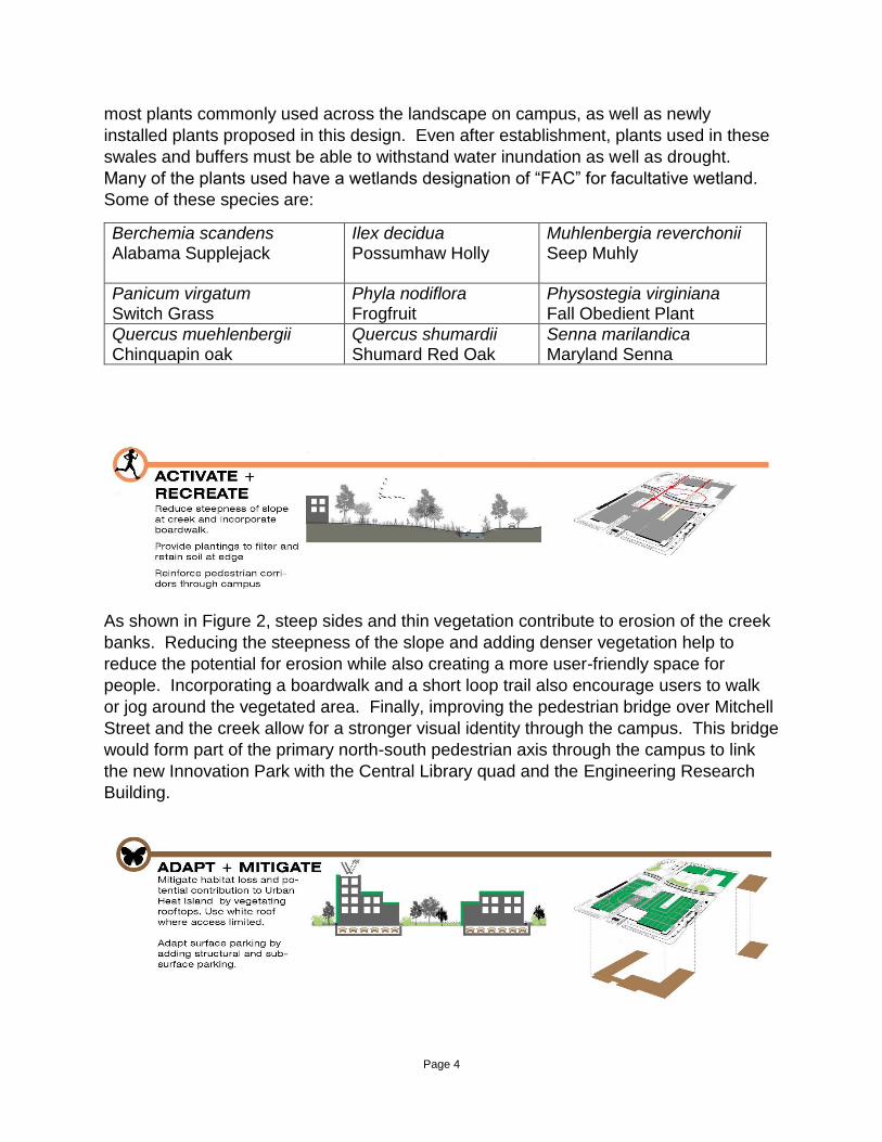
As shown in Figure 2, steep sides and thin vegetation contribute to erosion of the creek
banks. Reducing the steepness of the slope and adding denser vegetation help to
reduce the potential for erosion while also creating a more user-friendly space for
people. Incorporating a boardwalk and a short loop trail also encourage users to walk
or jog around the vegetated area. Finally, improving the pedestrian bridge over Mitchell
Street and the creek allow for a stronger visual identity through the campus. This bridge
would form part of the primary north-south pedestrian axis through the campus to link
the new Innovation Park with the Central Library quad and the Engineering Research
Building.

Page 5
The approximately 17 acres of asphalt parking lot currently on the site add to the urban
heat island effect by absorbing energy during the day and releasing it at night. Much of
this area will be replaced with rooftops, but these roofs will mitigate heat storage with
the use of living and white roofs. Living roofs can be low- or high- maintenance,
depending on the type of vegetation planted. This proposal includes several types of
living roofs: a vegetable garden requiring high levels of water, soil, and weeding; rooftop
gardens, also requiring weeding and occasional irrigation; and low maintenance roof,
consisting of xeric adapted native plants. Size of high-input gardens will be minimized,
and the majority of roof cover will be low maintenance.
Parking spaces taken over for Innovation Park will be gained through semi-underground
spaces located under the buildings as well as structural parking on a nearby surface lot.
The structural parking will allow more students to park closer to campus than before.

Page 6
Page 7
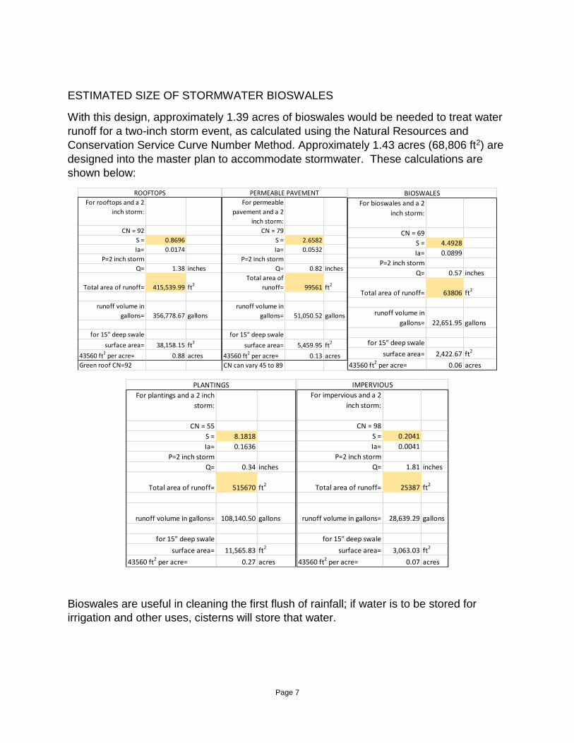
ESTIMATED SIZE OF STORMWATER BIOSWALES
With this design, approximately 1.39 acres of bioswales would be needed to treat water
runoff for a two-inch storm event, as calculated using the Natural Resources and
Conservation Service Curve Number Method. Approximately 1.43 acres (68,806 ft2) are
designed into the master plan to accommodate stormwater. These calculations are
shown below:
For rooftops and a 2
inch storm:
CN = 92
S = 0.8696
Ia= 0.0174
P=2 inch storm
Q= 1.38 inches
Total area of runoff= 415,539.99 ft2
runoff volume in
gallons= 356,778.67 gallons
for 15" deep swale
surface area= 38,158.15 ft2
43560 ft2 per acre= 0.88 acres
Green roof CN=92
ROOFTOPS
For permeable
pavement and a 2
inch storm:
CN = 79
S = 2.6582
Ia= 0.0532
P=2 inch storm
Q= 0.82 inches
Total area of
runoff= 99561 ft2
runoff volume in
gallons= 51,050.52 gallons
for 15" deep swale
surface area= 5,459.95 ft2
43560 ft2 per acre= 0.13 acres
CN can vary 45 to 89
PERMEABLE PAVEMENT
For bioswales and a 2
inch storm:
CN = 69
S = 4.4928
Ia= 0.0899
P=2 inch storm
Q= 0.57 inches
Total area of runoff= 63806 ft2
runoff volume in
gallons= 22,651.95 gallons
for 15" deep swale
surface area= 2,422.67 ft2
43560 ft2 per acre= 0.06 acres
BIOSWALES
For plantings and a 2 inch
storm:
CN = 55
S = 8.1818
Ia= 0.1636
P=2 inch storm
Q= 0.34 inches
Total area of runoff= 515670 ft2
runoff volume in gallons= 108,140.50 gallons
for 15" deep swale
surface area= 11,565.83 ft2
43560 ft2 per acre= 0.27 acres
PLANTINGS
For impervious and a 2
inch storm:
CN = 98
S = 0.2041
Ia= 0.0041
P=2 inch storm
Q= 1.81 inches
Total area of runoff= 25387 ft2
runoff volume in gallons= 28,639.29 gallons
for 15" deep swale
surface area= 3,063.03 ft2
43560 ft2 per acre= 0.07 acres
IMPERVIOUS
Bioswales are useful in cleaning the first flush of rainfall; if water is to be stored for
irrigation and other uses, cisterns will store that water.

Page 8
PLANT AND POLLINATOR DIVERSITY
Figure 3 A late season Queen butterfly caterpillar feeds on Milkweed growing wild at College Park Green in December.
Pollinators supported by an improved habitat include: ants, bees, beetles, birds,
butterflies, flies, moths, wasps, and true bugs (Hemiptera). Each of these pollinators
favor a certain type of bloom, which vary by shapes, colors, sizes, and scents. Different
pollinators seek different fuel sources from flowers; some feed on nectar, others
consume pollen, and still others chew flower petals. Including larval hosts for insects
also encourages diversity.
Post Oak, Quercus stellata, is a slow growing, but long-lived tree found in the narrow
band of Cross Timbers ecoregion, of which this site is a part. These trees are rarely
allowed to grow from seed in urban areas; allowing some unmowed areas of planting
would help to provide a nursery for these trees. They are also better adapted to the
poor soils and low water conditions in this area. They are able to fix carbon at higher
temperatures and with less water than other commonly planted trees.
Page 9
Page 10
EXPECTED OUTCOMES: SOCIAL
Outdoor multi-use spaces such as the Sundial Overlook and the Welcome Plaza allow
for informal gatherings as well as structured social events. Parking for buses at the
Welcome Plaza allows a first stop for visiting groups from area schools. This corner
location also provides a resting place and retail opportunity for parents visiting with
prospective students. The trails and enhanced walkways would bring more foot and
bike traffic through the area, and daily use of the spaces would be around 3,000 people
per day during weekdays.
EXPECTED OUTCOMES: ECONOMIC
A small hotel and conference center, administered through a public-private partnership,
would attract hospitality support, such as coffee shops and cafes, to the Cooper Street
corridor. These would provide a modest number of jobs to students. The university
might also provide a new training program in the hotel, which could take advantage of
federal Work Study programs to benefit students needing on-campus jobs. With new
research facilities, the University would be inn a good position to attract research grants,
which provide a large boost to the economic status of UT Arlington.
SUMMARY Innovation Park strives to combine a modern treatment of stormwater runoff with
sensitive use of hardscape in a university setting. It reduces the University’s
contribution to the urban heat island while providing high quality research, instruction,
recreation, and conference space to its users. Vegetated bioswales and roofs
contribute to the overall mental, physical, and environmental health of the University of
Texas at Arlington.
REFERENCES
Animal Pollination. United States Department of Agriculture Forest Service. Web. 2 Dec 2015.
Austin, Gary. Green Infrastructure for Landscape Planning. New York: Routledge, 2014. Print.
Bender, Kelly Conrad. Texas Wildscapes: Gardening for Wildlife. College Station: Texas A&M
University Press, 2009. Print.
Dvorak, Bruce, Brooke Byerley, and Astrid Volder. “Plant species survival on three water
conserving green roofs in a hot humid subtropical climate.” Journal of Living
Architecture.1.1 (2013): 39-53. Web. 1 Dec 2015.
Jaber, Fouad, Dotty Woodson, Christina LaChance, and Charris York. Stormwater
Management: Rain Gardens. Texas A&M AgriLife Communications 2012. Print.
Ladybird Johnson Wildflower Center Native Plant Database. University of Texas at Austin. Web.
15 Nov to 1 Dec 2015.
Novak, Celeste Allen, Eddie Van Giesen, and Kathy M DeBusk. Designing Rainwater
Harvesting Systems. Hoboken: Wiley, 2014. Print.
Water Reuse: Potential for Expanding the Nation's Water Supply through Reuse of Municipal
Wastewater. Water Science Technology Board. National Academy of Sciences. 2012.
Web. 2 Dec 2015.
Winguth, Arne, Jun Hak Lee, Yekang Ko. Climate Change/Extreme Weather Vulnerability and
Risk Assessment for Transportation Infrastructure in Dallas and Tarrant Counties North
Central Texas Vulnerability Assessment Team 2012. Print.
Winguth, A.M.E., and B. Kelp,. The Urban Heat Island of the North-Central Texas Region and
Its Relation to the 2011 Severe Texas Drought. Journal of Applied Meteorology and
Climatology, 52,2418-2433. 2013. Print.
Top Related