


Languages
Pages
Legal


HISTORIC RESOURCES INVENTORY - BUILDING AND STRUCTURES
-1-
Connecticut Commission on Culture & Tourism, One Constitution Plaza, 2nd Floor, Hartford, CT 06103
* Note: Please attach any additional or expanded information on a separate sheet.
GENERAL INFORMATIONBuilding Name (Common) ______________________________________________________________________
Building Name (Historic) _______________________________________________________________________
Street Address or Location ______________________________________________________________________
Town/City __________________________ Village ________________________ County ___________________
Owner(s) _______________________________________________________________ Public Private
PROPERTY INFORMATIONPresent Use: _________________________________________________________________________________
Historic Use: _________________________________________________________________________________
Accessibility to public: Exterior visible from public road? Yes No
Interior accessible? Yes No If yes, explain __________________________________________________
Style of building _______________________________________________ Date of Construction ____________
Material(s) (Indicate use or location when appropriate):
Clapboard Asbestos Siding Brick Wood Shingle Asphalt Siding
Fieldstone Board & Batten Stucco Cobblestone Aluminum Siding
Concrete (Type ______________) Cut Stone ( Type ______________) Other ______________
Structural System
Wood Frame Post & Beam Balloon Load bearing masonry Structural iron or steel
Other _______________________
Roof (Type)
Gable Flat Mansard Monitor Sawtooth
Gambrel Shed Hip Round Other ___________________________(Material) Wood Shingle Roll Asphalt Tin Slate Asphalt Shingle
Built up Tile Other ____________________
Number of Stories: __________ Approximate Dimensions __________________________________________
Structural Condition: Excellent Good Fair Deteriorated
Exterior Condition: Excellent Good Fair Deteriorated
Location Integrity: On original site Moved When? _____________
Alterations? Yes No If yes, explain: _______________________________________________________
FOR OFFICE USE: Town #_______ Site # _______ UTM ______________________________________
District: S NR If NR, Specify: Actual Potential
Please send completed form to: Stacey Vairo, National Register and State Register Coordinator, State Historic Preservation Office, Department of Economic and Community Development,
One Constitution Plaza, 2nd Floor, Hartford CT 06103 * Note: Please attach any additional or expanded information on a separate sheet.
The Inn at Mount Pleasant Record No. 24413Hodges, Alpheus, Farmstead / Deming, Mason and Ruth: Mount Pleasant Farm
505 University Drive
Torrington Torrington Green LitchfieldRobert Bombardieri, 505 University Drive, Torrington CT 06790
Agriculture/Subsistence: agricultural outbuilding; Domestic: single dwelling
Agriculture/Subsistence: agricultural outbuilding; Domestic: single dwelling
English bank barn, Vernacular style c. 1870
✔ Cast, block ✔ Vertical woodsiding
✔ ✔ ✔
✔
✔
✔
1 1/2, B 28' x 90'
✔
✔
Barn raised on concrete block masonry foundation, early 20th c.
Please send completed form to: Stacey Vairo, National Register and State Register Coordinator, State Historic Preservation Office, Department of Economic and Community Development,
One Constitution Plaza, 2nd Floor, Hartford CT 06103 * Note: Please attach any additional or expanded information on a separate sheet.
The Inn at Mount Pleasant Record No. 24413
Hodges, Alpheus, Farmstead / Deming, Mason and Ruth: Mount Pleasant Farm
505 University Drive
Torrington Torrington Green Litchfield
Robert Bombardieri, 505 University Drive, Torrington CT 06790
Agriculture/Subsistence: agricultural outbuilding; Domestic: single dwelling
Agriculture/Subsistence: agricultural outbuilding; Domestic: single dwelling
English bank barn, Vernacular style c. 1870
✔ Cast, block ✔ Vertical wood siding
✔ ✔ ✔
✔
✔
✔
1 1/2, B 28' x 90'
✔
✔
Barn raised on concrete block masonry foundation, early 20th c.

-2-
Historic Resources Inventory
PROPERTY INFORMATION (CONT’D)
Related outbuildings or landscape features: Barn Shed Garage Carriage House Shop Garden Other landscape features or buildings: _______________________________________________________
Surrounding Environment:
Open land Woodland Residential Commercial Industrial Rural
High building density Scattered buildings visible from site
• Interrelationship of building and surroundings:
• Other notable features of building or site (Interior and/or Exterior)
Architect ______________________________________ Builder _______________________________________
• Historical or Architectural importance:
• Sources:
Photographer __________________________________________________________ Date _________________
View __________________________________________________________ Negative on File _______________
Name ________________________________________________________________ Date _________________
Organization ________________________________________________________________________________
Address ____________________________________________________________________________________
• Subsequent fi eld evaluations:
Threats to the building or site:
None known Highways Vandalism Developers Renewal Private
Deterioration Zoning Other ________________ Explanation ________________
505 University Drive, Torrington CT Record No. 24413
✔
✔ Stone walls, stream
✔ ✔ ✔ ✔
✔
See continuation sheet.
See continuation sheet.
See continuation sheet.
Cunningham, Janice, Connecticut's Agricultural Heritage: an Architectural and Historical Overview, Connecticut Trust for HistoricPreservation & State Historic Preservation Office, 2012.
See continuation sheet.
Charlotte Hitchcock 7/24/2012
Multiple Views CTHPCharlotte Hitchcock 8/07/2012
Connecticut Trust for Historic Preservation
940 Whitney Avenue, Hamden CT 06517
Latitude, Longitude:41.833702, -73.15915
✔
505 University Drive, Torrington CT Record No. 24413
✔
✔ Stone walls, stream
✔ ✔ ✔ ✔
✔
See continuation sheet.
See continuation sheet.
See continuation sheet.
Cunningham, Janice, Connecticut's Agricultural Heritage: an Architectural and Historical Overview, Connecticut Trust for Historic Preservation & State Historic Preservation Office, 2012. See continuation sheet.
Charlotte Hitchcock 7/24/2012
Multiple Views CTHP
Charlotte Hitchcock 8/07/2012
Connecticut Trust for Historic Preservation
940 Whitney Avenue, Hamden CT 06517
Latitude, Longitude: 41.833702, -73.15915
✔
Connecticut State Historic Preservation Office, Department of Economic and Community Development
One Constitution Plaza, 2nd Floor, Hartford CT 06103 HISTORIC RESOURCES INVENTORY FORM – BUILDING AND STRUCTURES continuation sheet 505 University Drive, Torrington CT Record No. 24413 3
_________________________________________________________________________________
• Interrelationship of building and surroundings:
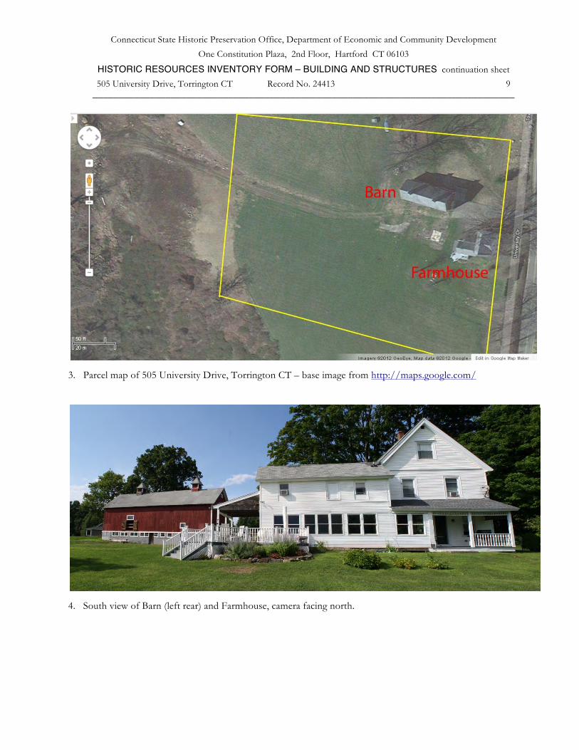
This property has 3.2 acres remaining from a larger parcel of 70 or more acres, and has been recently subdivided into large lots for residential use. The site is located northwest of the center of Torrington near the top of a south-facing hillside. A historic site, the birthplace of abolitionist John Brown, is nearby to the northwest on John Brown Road. The University of Connecticut Torrington campus is to the north on University Drive, which was known as Town Farm Road until the campus was located at the site of the former town poor farm. Stillwater Pond is nearby to the east, and Nickel Mine Brook runs near the southern extent of the former farm. The area is a mix of open former farmland, woods (now water supply land), recent development (campus and residential), and some working agriculture. The ruins of old nickel mines, factory sites, and old homesteads are vanishing into second growth forests.
The earliest areas of Torrington to be settled included the uplands on both sides of the Naugatuck River. Historic properties on the west side include the Strong House at 1167 Highland Avenue, listed on the State Register of Historic Places, and the John Brown birthplace, listed on the Connecticut Freedom Trail; the area was the site of the earliest English settlements. Also included in this thematic nomination to the State Register is the nearby Wright’s Barn at 104 Wright Road. East of the river, the Torringford National Register Historic District along Torringford Road (Route 183) includes historic homes, a number of which have associated barns, as this was the best farmland in the town. In the 19th century, the focus of development shifted to the river valley where industries arose and thrived. Several historic districts and properties are located in the downtown area.
The Farmhouse on this parcel is a 2 ½-story c. 1850s gable-roofed structure, 26’ x 30’. The main ridge-line is oriented north-south, parallel to the road; a cross gable faces east toward the road. A full-width 1-story shed-roofed porch runs across the south gable-end and shelters the formal entrance. The driveway runs along the north side leading to the west eave-side where there is a 2-story ell, 16’ x 28’, extending west. The house is designed in a vernacular Victorian style with its cross gable, three-bay south gable façade, bargeboard rakes, and colored glass decorative insets in the front door. The attic gables, now vinyl-sided, have flared lower portions suggesting that the original siding may have been shingles. Many of the double-hung windows are modern replacements. The rear ell, which is likely to be the oldest part of the structure, possible 18th-century, is a 2-story wing incorporating a modern kitchen-dining room with a wall of seven modern double-hung windows facing south to the expansive view. The interior has been renovated with bedroom suites as a bed and breakfast inn.
West and north of the Farmhouse is a former barnyard formed by three structures, of which two have been recently demolished. The extant main barn is northwest of the house. Abutting the barn at its southwest corner was formerly an open-sided gable-roofed shed with a metal roof. West of the house and south of the main barn was a small 1-story gable-roofed barn or shed with its ridge-line oriented east-west. It had shed-roofed additions wrapping around the west and south sides. These structures defined the sheltered barnyard area adjacent to the basement stable level of the barn. A silo foundation is located along the north side of the barn, east of the main doorway.
Today the barn and house are surrounded by mowed open land and beyond by woodland, with a long southwestern view over the lower fields to the Litchfield hills beyond.
• Other notable features of building or site (Interior and/or Exterior): Architectural description:
Inventory of structures (C – contributing, NC – non-contributing): House c. 1855 and earlier C Barn c. 1870 C
Barn:
This is a 1 ½-story six-bay gable-roofed bank barn with a basement dairy stable. The barn is 28’ x 90’, with its ridge-line oriented east-west. It is a post and beam-framed structure elevated on a 1-story concrete block masonry

Connecticut State Historic Preservation Office, Department of Economic and Community Development
One Constitution Plaza, 2nd Floor, Hartford CT 06103 HISTORIC RESOURCES INVENTORY FORM – BUILDING AND STRUCTURES continuation sheet 505 University Drive, Torrington CT Record No. 24413 4
_________________________________________________________________________________ foundation, recently repaired with areas of cast-in-place concrete. The main entry is a pair of oversized sliding doors in the 2nd from the right (west) bay of the north eave-side, accessed by an earthen ramp. The east gable-end and south eave-side have fully exposed basement walls. On the west gable-end the basement is partially exposed.
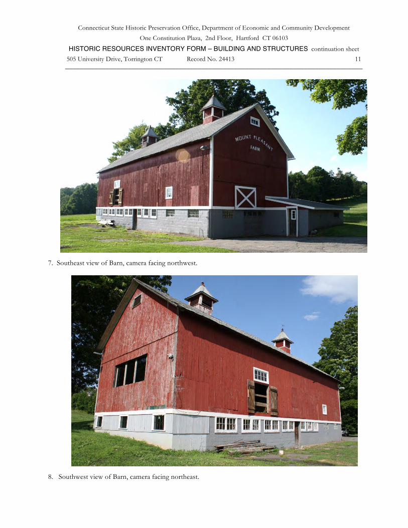
Exterior:
The north eave-side has, from left (east) to right, a hinged door with no trim at the main level, a hay door with a chamfered upper left corner in the loft level, a hay door with no trim in the loft level above a four-pane stable window with trim in the main level, the oversized pair of sliding doors which have X-braces in the lower panels, and a blank bay to the right of the doors with the foundation partially visible as the grade slopes down toward the west. There are two basement windows near the left (east) corner, filled with glass block. A photograph prior to recent repairs shows that the doors did not originally have the x-bracing and there were marks of an attached shed at the location of an extant silo foundation at the center bay. A slightly pitched wood hatch cover is located on the ground adjacent to the north wall at this point.
The east gable-end, which faces the street, has a concrete block basement wall with a 3 x 5 unit glass block window near the left (south) corner, an overhead door at the center, and a 1-story shed-roofed concrete block milk room addition attached to the right portion, extending north beyond the corner of the main barn. This has a pass-through door in its south side, two small window openings in its east eave-side, and a glass block window in its north side. At the main level of the east gable-end, there is a sliding hay door off-center toward the left. The deeply dropped girt line siding divide features a saw-tooth pattern in the board ends. In the attic gable, the farm name “Mount Pleasant Farm” is written in applied letters and above near the peak is a three-pane window with trim.
The south eave-side has at the basement level, from left (west) to right, four pairs of six-pane stable windows, a pass-through door, three six-pane stable windows, and two window openings filled with glass block in a 3 x 5 unit pattern. Above at the main level the first bay at the left (west) is blank, the second bay has a pair of hinged hay doors under an eight-pane horizontal window, and the fifth bay has a six-pane stable window at the main level.
The west gable-end formerly had a concrete block foundation wall with an areaway leading down several steps into the lower level where there is a concrete slab floor configured for dairy cows. This was replaced in 2011 by a concrete foundation wall up to grade and a wood-framed knee wall with three eight-pane barn sash windows. Above at the main level is a recently-installed panel of three single-pane fixed windows. There is an attic window below the peak.
Siding is vertical flush-board painted red with some white trim. The siding has areas of repairs and patches. The roof has deep overhangs at the rakes and eaves, exposed rafter tails, and is covered in asphalt shingles. There is a notch on the north eave where the silo formerly connected to the barn wall. There are two cupolas on the ridge-line approximately one bay in from each end. These have steep hip roofs with slightly flared eaves. Both have small finials at the peak and the eastern cupola has a weather vane. There are louvered openings on all four sides of both cupolas.
Interior:
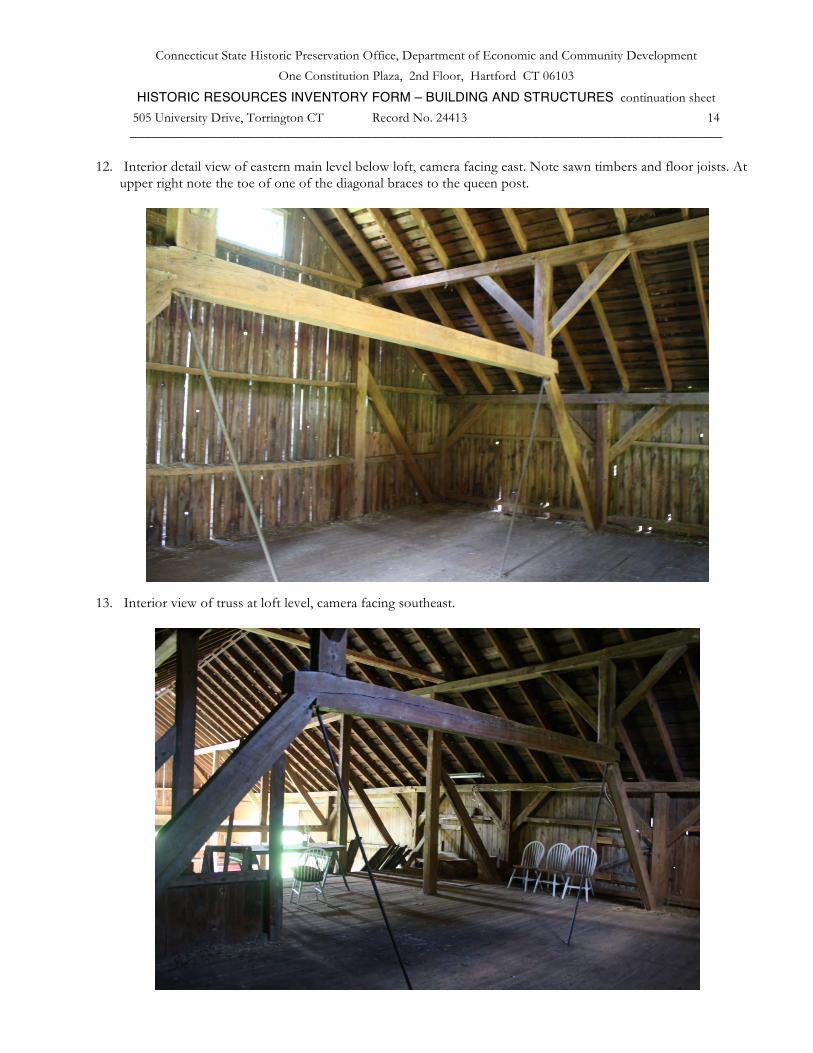
The interior construction is a square rule post and beam frame constructed with circular-sawn timbers and joined with wood pegs. The typical bents in the western three bays have two interior posts, deeply dropped tie-girts (roughly 4’ below the plates), and vertical queen posts supporting longitudinal purlin plates at the mid-span of the common rafters. This three-aisle layout is typical of the New England barns of the last quarter of the 19th century, but is here combined with an eave-side entry in the second bay from the west end. The queen posts are braced down to the tie girts with massive diagonal braces, evidently a purposeful strategy to leave the upper center free for a hay track which is suspended under the ridge-board. The three western bays are 16’ wide.
The eastern three bays are narrower, 10’ and 12’ wide, and have the tie girts about 6’ below the plates. The girts support a loft floor. The first bent in from the east end has an unusual configuration; the two interior posts are truncated at about 7’ above the loft floor and are carried by a wood and steel cable trapezoidal truss which allows the main level to have a clear span across the eastern two bays. It is unclear what function this low but wide clear area served, although there is a sliding door which would have allowed access to it. Possibly, prior to the insertion of
Connecticut State Historic Preservation Office, Department of Economic and Community Development
One Constitution Plaza, 2nd Floor, Hartford CT 06103 HISTORIC RESOURCES INVENTORY FORM – BUILDING AND STRUCTURES continuation sheet 505 University Drive, Torrington CT Record No. 24413 5
_________________________________________________________________________________ the basement level below, there may have been a ramped entrance at this end for livestock to live in the eastern three bays while the western bays functioned as hay storage.
In the northeast corner of this area there is a grain bin with a hopper that feeds down to the stable area below.
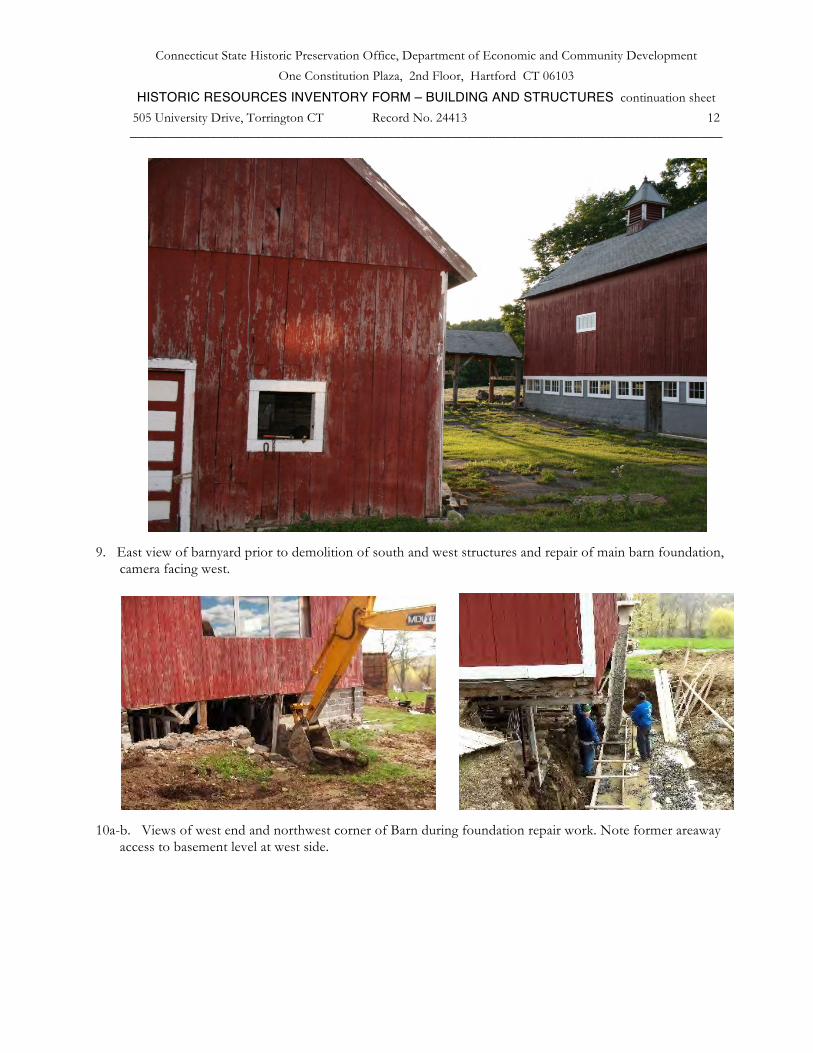
The basement level consists of a regular arrangement of wood and steel posts supporting heavy timber girders. Sawn wood joists run longitudinally to carry the main level floor planks. The basement is laid out for two rows of dairy cows with wood and metal stanchions, cows facing out and manure gutters along the center. The south side of the space is amply lit by the stable windows. At the southeast corner there is a metal bull- or calf-pen enclosure and the windows in this area are glass block. The original early 20th-century concrete “cinder” block walls below the window sills and the fieldstone north retaining wall, have been substantially replaced with cast concrete walls due to failure of the block masonry.
• Historical or Architectural importance:
Applicable Connecticut State Register Criterion: 1. Associated with the lives of persons significant in our past; 2. Embodying the distinctive characteristics of a type, period, or method of construction.
This farmstead derives significance from its history of use and ownership by the Hodges family, locally prominent in farming, manufacturing, and trade in the first half of the 19th century, and by its architectural quality and integrity as an example of the Victorian barn modified in the 20th century to a ground level stable dairy barn. The barn is an excellent example of its type. It illustrates Victorian period construction practice with the original barn frame, combining characteristics of the New England type, with the traditional eave-entry configuration which worked well on the sloping site. The basement dairy stable and milk room addition demonstrate the typical changes in the history of a barn in the 20th century.
Historical background:
Torrington was settled in the 18th century by residents from Windsor; property-owning residents were given the townships to divide among themselves, and assignment of land to the proprietors was by lot. Following the division of land, the areas that were first settled were the uplands to the west and east of the Naugatuck River, where the land was most suitable for farming. Settlement occurred to the east at Torringford and to the west in the West Side (Highland Avenue) area and at Torrington Green, located at today’s intersection of University Drive and Hodges Hill Road.
The Hodges family settled on the south-facing slope of Brandy Hill at Torrington Green. Dr. Elkanah Hodges (1747-1797) located his home, opened a store in the village, and prospered as a physician, merchant, and landowner until his death at age 50. His widow, Rebecca Whiting Hodges (1756-1839) took over all aspects of the business except the medical practice, and managed successfully for ten years, at which time she handed over the mercantile business to sons Erastus (1781-1847) and son Willard (1778-1817) Erastus took over the mercantile business while Willard took his share of land for farming. Elkanah and Rebecca had seven children, all of whom survived to adulthood. Erastus built a new home designed and built by David Hoadley, and engaged in a number of businesses including wholesaling cheese to the southern states, manufacture of wooden clocks, a cotton thread mill, a brass mill, and real estate. He also became a town selectman, state representative, and justice of the peace.
Erastus’s younger brother Alpheus (1792-1870), the next-to-last of the seven, established his farmstead to the north of the Torrington Green family home, farming with his mother Rebecca, and built the Farmhouse between 1850 and his death in 1870. He never married. By 1874, after Alpheus Hodges’ death, the Beers Map identifies the A. Hodges Estate as including the farmstead and a location along the West Branch of the Naugatuck River in the area then known as Cotton Hollow (later West Torrington). Erastus Hodges’s son, Levi (1817-1860) was shown in 1874 at the Hodges family location in Torrington Green.
The main barn would likely have been built at roughly the same time as the house, based on its Victorian-era construction methods using circular-sawn lumber, iron rods to form truss-work, the three-aisle layout, the cupolas,
Connecticut State Historic Preservation Office, Department of Economic and Community Development
One Constitution Plaza, 2nd Floor, Hartford CT 06103 HISTORIC RESOURCES INVENTORY FORM – BUILDING AND STRUCTURES continuation sheet 505 University Drive, Torrington CT Record No. 24413 6
_________________________________________________________________________________ etc. Thus it may have been built by Alpheus Hodges, between 1855 and about 1870. The prosperity derived from the Hodges family’s commercial businesses likely enabled erection of a large and impressive barn at this period.
By the 1920s, as shown by census records, the Deming family had moved in at the upper farm, which they named Mt. Pleasant. The 1930 census shows Arthur C. Deming, age 40, as a General Farmer. His wife was Ruth and their children were Mason A. Deming (who listed his occupation as lumber), Helen, Olive, Elmyra, Clayton, and Arthur Jr. Mason Deming (1909-2002) took over as the owner, acquiring the property in the 1940s and farming into the 1980s. In 2006 the property was purchased by the current owner Robert Bombardieri.
Deming was a dairy farmer. In the early 1900s, the barn was raised up and a foundation of concrete block masonry inserted to set up the ground level stable barn layout that was state-of-the-art at that time. The lower section had about 36 stalls and the upper floors were used for hay storage. The milk room addition, conveniently located for loading from the driveway side, conformed to the health regulations of the time.
Robert Bombardieri has subdivided the property to create 15 home lots, reserving the farmhouse and barn as his own home, and deeding 16 acres to the local land trust as open space. Hay is still cut by Bruce Deming, nephew of Mason. The barn is protected by an easement granted to the City of Torrington. Bombardieri has rehabilitated the farmhouse as a bed and breakfast inn, and has made significant repairs to the barn foundation with the help of a matching grant administered by the Connecticut Trust for Historic Preservation.
Architectural significance:
This farmstead derives significance from it history of use and ownership by the Hodges family, locally prominent in farming, manufacturing, and trade in the first half of the 19th century, and by its architectural quality and integrity as an example of the Victorian barn modified in the 20th century to a ground level stable dairy barn.
The Hodges family prospered in commerce and as farmers from before 1800 until the just before 1850, during the peak period of water-powered manufacturing. The story of the Hodges family’s enterprises exemplifies the successes and failures of entrepreneurship and inventiveness in the early decades of the United States. While father Elkanah and brother Erastus were the most ambitious in development of business enterprises, Alpheus continued operating a farm, as did his nephew Levi down the road; and Alpheus appears to have been somewhat involved in investing in the family ventures.
A century later, the Demings operated a good-sized dairy farm of about 40 milking cows, with substantial acreage, continuing until the 1980s. During their time, the modern dairy barn configuration was installed.
The extant house and barn embody the history of the last 150 years, with the barn retaining nearly all of its original fabric. It is an excellent example of its type. It illustrates Victorian period construction practice with the original barn frame, combining characteristics of the New England type that was coming into prevalence at the time, with the traditional eave-entry configuration, well suited to the sloping site. Modifications to introduce the basement dairy stable and added milk room addition, further demonstrate the typical changes in the history of a barn through the early 20th century. The current development of the surroundings for residential subdivision, while it follows the trend toward suburbanization in much of Connecticut, has preserved a sense of the agricultural environment through setting aside preserved open space which includes most of the view-shed from the barn and farmhouse.

Connecticut State Historic Preservation Office, Department of Economic and Community Development
One Constitution Plaza, 2nd Floor, Hartford CT 06103 HISTORIC RESOURCES INVENTORY FORM – BUILDING AND STRUCTURES continuation sheet 505 University Drive, Torrington CT Record No. 24413 7
_________________________________________________________________________________
• Sources (continuation): Photographs and field notes by Robert Bombardieri 05/27/2010, Charlotte Hitchcock 7/24/2012.
Interview with Robert Bombardieri 7/24/2012, at the site.
Map resources:
Town of Torrington Assessor's Record http://www.equalitycama.com/tvweb/Details.aspx?city=Torrington&uid=2951 Parcel ID: 223/001/005 (3.21 acres)
Aerial views from: http://maps.google.com/ 8/08/2012 and http://www.bing.com/maps/ accessed 6/21/2011.
Historical aerial photography and maps accessed at UConn MAGIC: http://magic.lib.uconn.edu/mash_up/1934.html http://magic.lib.uconn.edu/historical_maps_connecticut_towns.html . Bailey, O.H., View of Wolcottville Conn, O.H. Bailey, Boston, 1875-8. Bailey, O.H., Bird’s Eye View of Torrington Conn, Hughes & Bailey, New York, 1907. Beers, F.W. ,Atlas of Litchfield County, F.W. Beers & Co., 1874. Norris, George E., Torrington Conn. 1889, Geo. E. Norris, Brockton Mass, 1889.
USGS Historical Maps accessed 6/22/2012 at http://historical.mytopo.com/ .
UTM coordinates: http://itouchmap.com/latlong.html .
Print and internet resources:
Andrews, Gregory E., Torringford Street National Register Historic District No. 91000991, National Park Service, 1991.
Bombardieri, Robert, Application for Barns Grant, Connecticut Trust for Historic Preservation, 2011, on file at CT Trust for Historic Preservation.
Connecticut Monuments, John Brown Birthplace, http://ctmonuments.net , accessed 8/03/2013.
Connecticut Trust for Historic Preservation, Historic Barns of Connecticut Resource Inventory, 2010, http://www.connecticutbarns.org/24413 .
Hodges, Theodore B., Erastus Hodges 1781-1847: Connecticut manufacturer, merchant, & entrepreneur, Phoenix Publishing, West Kennebunk, Maine, 1994.
McEachern, Mark, & Clapp, Carol; Strong, Jacob, Jr., House State Register Nomination, Torrington Historical Society & Connecticut State Historic Preservation Office, Hartford CT, 2012.
Sexton, James, PhD; Survey Narrative of the Connecticut Barn, Connecticut Trust for Historic Preservation, Hamden, CT, 2005, http://www.connecticutbarns.org/history.
Rossano, Geoffrey, Historic Resource Inventory Form, Torrington Historic Preservation Trust, 1994.
U.S. Federal Census, accessed at http://persi.heritagequestonline.com/hqoweb/library/do/census/search/basic
Visser, Thomas D., Field Guide to New England Barns & Farm Buildings, University Press of New England, 1997.

Connecticut State Historic Preservation Office, Department of Economic and Community Development
One Constitution Plaza, 2nd Floor, Hartford CT 06103 HISTORIC RESOURCES INVENTORY FORM – BUILDING AND STRUCTURES continuation sheet 505 University Drive, Torrington CT Record No. 24413 8
_________________________________________________________________________________
1. Location map of 505 University Drive, Torrington CT – from http://maps.google.com/ accessed 8/08/2012.
2. Southwest view – aerial “bird’s-eye” map of 505 University Drive, Torrington CT –
http://www.bing.com/maps accessed 6/21/2011. View shows the farmstead prior to the demolition of the south and west structures. Note the circular silo foundation at right (north) side of the main barn.
Connecticut State Historic Preservation Office, Department of Economic and Community Development
One Constitution Plaza, 2nd Floor, Hartford CT 06103 HISTORIC RESOURCES INVENTORY FORM – BUILDING AND STRUCTURES continuation sheet 505 University Drive, Torrington CT Record No. 24413 9
_________________________________________________________________________________
3. Parcel map of 505 University Drive, Torrington CT – base image from http://maps.google.com/
4. South view of Barn (left rear) and Farmhouse, camera facing north.

Connecticut State Historic Preservation Office, Department of Economic and Community Development
One Constitution Plaza, 2nd Floor, Hartford CT 06103 HISTORIC RESOURCES INVENTORY FORM – BUILDING AND STRUCTURES continuation sheet
505 University Drive, Torrington CT Record No. 24413 10 _________________________________________________________________________________
5. Southwest view of Farmhouse, camera facing northeast.
6. Northwest view of Barn, camera facing southeast.
Connecticut State Historic Preservation Office, Department of Economic and Community Development
One Constitution Plaza, 2nd Floor, Hartford CT 06103 HISTORIC RESOURCES INVENTORY FORM – BUILDING AND STRUCTURES continuation sheet
505 University Drive, Torrington CT Record No. 24413 11 _________________________________________________________________________________
7. Southeast view of Barn, camera facing northwest.
8. Southwest view of Barn, camera facing northeast.
Connecticut State Historic Preservation Office, Department of Economic and Community Development
One Constitution Plaza, 2nd Floor, Hartford CT 06103 HISTORIC RESOURCES INVENTORY FORM – BUILDING AND STRUCTURES continuation sheet
505 University Drive, Torrington CT Record No. 24413 12 _________________________________________________________________________________
9. East view of barnyard prior to demolition of south and west structures and repair of main barn foundation,
camera facing west.
10a-b. Views of west end and northwest corner of Barn during foundation repair work. Note former areaway
access to basement level at west side.

Connecticut State Historic Preservation Office, Department of Economic and Community Development
One Constitution Plaza, 2nd Floor, Hartford CT 06103 HISTORIC RESOURCES INVENTORY FORM – BUILDING AND STRUCTURES continuation sheet
505 University Drive, Torrington CT Record No. 24413 13 _________________________________________________________________________________
11. Interior view of western three bays, camera facing northwest.
Connecticut State Historic Preservation Office, Department of Economic and Community Development
One Constitution Plaza, 2nd Floor, Hartford CT 06103 HISTORIC RESOURCES INVENTORY FORM – BUILDING AND STRUCTURES continuation sheet
505 University Drive, Torrington CT Record No. 24413 14 _________________________________________________________________________________
12. Interior detail view of eastern main level below loft, camera facing east. Note sawn timbers and floor joists. At
upper right note the toe of one of the diagonal braces to the queen post.
13. Interior view of truss at loft level, camera facing southeast.
Connecticut State Historic Preservation Office, Department of Economic and Community Development
One Constitution Plaza, 2nd Floor, Hartford CT 06103 HISTORIC RESOURCES INVENTORY FORM – BUILDING AND STRUCTURES continuation sheet
505 University Drive, Torrington CT Record No. 24413 15 _________________________________________________________________________________
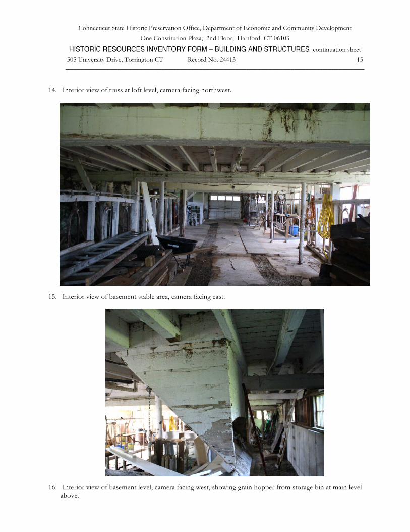
14. Interior view of truss at loft level, camera facing northwest.
15. Interior view of basement stable area, camera facing east.
16. Interior view of basement level, camera facing west, showing grain hopper from storage bin at main level
above.

Connecticut State Historic Preservation Office, Department of Economic and Community Development
One Constitution Plaza, 2nd Floor, Hartford CT 06103 HISTORIC RESOURCES INVENTORY FORM – BUILDING AND STRUCTURES continuation sheet
505 University Drive, Torrington CT Record No. 24413 16 _________________________________________________________________________________
17. Interior view of basement cow stanchions, camera facing northeast. Note portion of original fieldstone north
wall at left rear, new concrete wall at center rear.
18. South view of barn, camera facing north. At left rear is a new home recently constructed on the adjacent lot; at
right the western porch of the Farmhouse.
Top Related